

Proxy (climate)
Encyclopedia
Paleoclimatology
Paleoclimatology is the study of changes in climate taken on the scale of the entire history of Earth. It uses a variety of proxy methods from the Earth and life sciences to obtain data previously preserved within rocks, sediments, ice sheets, tree rings, corals, shells and microfossils; it then...
, climate proxies are preserved physical characteristics of the past that stand in for direct measurements (as statistical proxies
Proxy (statistics)
In statistics, a proxy variable is something that is probably not in itself of any great interest, but from which a variable of interest can be obtained...
), to enable scientists to reconstruct the climatic conditions
Climate
Climate encompasses the statistics of temperature, humidity, atmospheric pressure, wind, rainfall, atmospheric particle count and other meteorological elemental measurements in a given region over long periods...
that prevailed during much of the Earth's history. As reliable modern records of climate only began in the 1880s, proxies provide a means for scientists to determine climatic patterns before record-keeping began. Examples of proxies include ice cores, tree rings, sub-fossil pollen
Palynology
Palynology is the science that studies contemporary and fossil palynomorphs, including pollen, spores, orbicules, dinoflagellate cysts, acritarchs, chitinozoans and scolecodonts, together with particulate organic matter and kerogen found in sedimentary rocks and sediments...
, boreholes, corals, and lake and ocean sediments
Sediment
Sediment is naturally occurring material that is broken down by processes of weathering and erosion, and is subsequently transported by the action of fluids such as wind, water, or ice, and/or by the force of gravity acting on the particle itself....
. The character of deposition or rate of growth of the proxies' material has been influenced by the climatic conditions of the time in which they were laid down or grew. Chemical traces produced by climatic changes, such as quantities of particular isotopes, can be recovered from proxies. Some proxies, such as gas bubbles trapped in ice, enable traces of the ancient atmosphere to be recovered and measured directly to provide a history of fluctuations in the composition of the Earth's atmosphere. To produce the most precise results, systematic cross-verification between proxy indicators is necessary for accuracy in readings and record-keeping.
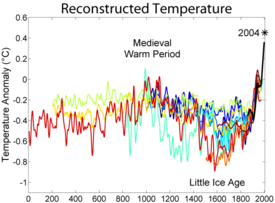
Proxies can be combined to produce temperature reconstructions longer than the instrumental temperature record
Instrumental temperature record
The instrumental temperature record shows fluctuations of the temperature of the global land surface and oceans. This data is collected from several thousand meteorological stations, Antarctic research stations and satellite observations of sea-surface temperature. Currently, the longest-running...
and can inform discussions of global warming
Global warming
Global warming refers to the rising average temperature of Earth's atmosphere and oceans and its projected continuation. In the last 100 years, Earth's average surface temperature increased by about with about two thirds of the increase occurring over just the last three decades...
. The distribution of proxy records, just like the instrumental record, is strongly non-uniform, with more records in the northern hemisphere.
Drilling

Core sample
A core sample is a cylindrical section of a naturally occurring substance. Most core samples are obtained by drilling with special drills into the substance, for example sediment or rock, with a hollow steel tube called a core drill. The hole made for the core sample is called the "core hole". A...
from within ice sheets in the Greenland
Greenland
Greenland is an autonomous country within the Kingdom of Denmark, located between the Arctic and Atlantic Oceans, east of the Canadian Arctic Archipelago. Though physiographically a part of the continent of North America, Greenland has been politically and culturally associated with Europe for...
, Antarctic
Antarctic
The Antarctic is the region around the Earth's South Pole, opposite the Arctic region around the North Pole. The Antarctic comprises the continent of Antarctica and the ice shelves, waters and island territories in the Southern Ocean situated south of the Antarctic Convergence...
, and North American
North American
North American generally refers to an entity, people, group, or attribute of North America, especially of the United States and Canada together.-Culture:*North American English, a collective term used to describe American English and Canadian English...
regions. First attempts of extraction occurred in 1956 as part of the International Geophysical Year
International Geophysical Year
The International Geophysical Year was an international scientific project that lasted from July 1, 1957, to December 31, 1958. It marked the end of a long period during the Cold War when scientific interchange between East and West was seriously interrupted...
. As original means of extraction, the U.S. Army’s Cold Regions Research and Engineering Laboratory
Cold Regions Research and Engineering Laboratory
The Cold Regions Research and Engineering Laboratory is a United States Army Corps of Engineers, Engineer Research and Development Center research facility headquartered in Hanover, New Hampshire that provides scientific and engineering support to the U.S. government and its military with a core...
used an 80 feet (24.4 m)-long modified electrodrill in 1968 at Camp Century, Greenland
Greenland
Greenland is an autonomous country within the Kingdom of Denmark, located between the Arctic and Atlantic Oceans, east of the Canadian Arctic Archipelago. Though physiographically a part of the continent of North America, Greenland has been politically and culturally associated with Europe for...
, and Byrd Station
Byrd Station
Byrd Station refers to a research station established by the United States during the International Geophysical Year by the U.S. Navy during Operation Deep Freeze II in West Antarctica at 80°, 120°W...
, Antarctica. Their machinery could drill through 15–20 feet of ice
Ice sheet
An ice sheet is a mass of glacier ice that covers surrounding terrain and is greater than 50,000 km² , thus also known as continental glacier...
in 40–50 minutes. From 1300 to 3000 feet (914.4 m) in depth, core sample
Core sample
A core sample is a cylindrical section of a naturally occurring substance. Most core samples are obtained by drilling with special drills into the substance, for example sediment or rock, with a hollow steel tube called a core drill. The hole made for the core sample is called the "core hole". A...
s were 4 ¼ inches in diameter
Diameter
In geometry, a diameter of a circle is any straight line segment that passes through the center of the circle and whose endpoints are on the circle. The diameters are the longest chords of the circle...
and 10 to 20 feet (6.1 m) long. Deeper samples
Core sample
A core sample is a cylindrical section of a naturally occurring substance. Most core samples are obtained by drilling with special drills into the substance, for example sediment or rock, with a hollow steel tube called a core drill. The hole made for the core sample is called the "core hole". A...
of 15 to 20 feet (6.1 m) long were not uncommon. Every subsequent drilling
Drilling
Drilling is a cutting process that uses a drill bit to cut or enlarge a hole in solid materials. The drill bit is a multipoint, end cutting tool...
team improves their method with each new effort.
Proxy
Presence of water molecule isotopic compositions of 16O and 18O in an ice coreIce core
An ice core is a core sample that is typically removed from an ice sheet, most commonly from the polar ice caps of Antarctica, Greenland or from high mountain glaciers elsewhere. As the ice forms from the incremental build up of annual layers of snow, lower layers are older than upper, and an ice...
help determine past temperatures
Paleoclimatology
Paleoclimatology is the study of changes in climate taken on the scale of the entire history of Earth. It uses a variety of proxy methods from the Earth and life sciences to obtain data previously preserved within rocks, sediments, ice sheets, tree rings, corals, shells and microfossils; it then...
and snow accumulations. The heavier isotope
Isotope
Isotopes are variants of atoms of a particular chemical element, which have differing numbers of neutrons. Atoms of a particular element by definition must contain the same number of protons but may have a distinct number of neutrons which differs from atom to atom, without changing the designation...
(18O) condenses more readily as temperatures decrease and falls as precipitation
Precipitation (meteorology)
In meteorology, precipitation In meteorology, precipitation In meteorology, precipitation (also known as one of the classes of hydrometeors, which are atmospheric water phenomena is any product of the condensation of atmospheric water vapor that falls under gravity. The main forms of precipitation...
, while the lighter isotope
Isotope
Isotopes are variants of atoms of a particular chemical element, which have differing numbers of neutrons. Atoms of a particular element by definition must contain the same number of protons but may have a distinct number of neutrons which differs from atom to atom, without changing the designation...
(16O) can fall in even colder conditions. The farther north
North
North is a noun, adjective, or adverb indicating direction or geography.North is one of the four cardinal directions or compass points. It is the opposite of south and is perpendicular to east and west.By convention, the top side of a map is north....
elevated levels of an 18O isotope are detected signals a warming over time.
In addition to oxygen isotopes, water contains hydrogen isotopes - 1H and 2H, usually referred to as H and D (for deuterium
Deuterium
Deuterium, also called heavy hydrogen, is one of two stable isotopes of hydrogen. It has a natural abundance in Earth's oceans of about one atom in of hydrogen . Deuterium accounts for approximately 0.0156% of all naturally occurring hydrogen in Earth's oceans, while the most common isotope ...
) - that are also used for temperature proxies. Normally, ice cores from Greenland are analyzed for δ18O and those from Antarctica for δ-deuterium. Those cores that analyze for both show a lack of agreement. (In the figure, δ18O is for the trapped air, not the ice. δD is for the ice.)
Air bubbles in the ice, which contain trapped greenhouse gases such as carbon dioxide
Carbon dioxide
Carbon dioxide is a naturally occurring chemical compound composed of two oxygen atoms covalently bonded to a single carbon atom...
and methane
Methane
Methane is a chemical compound with the chemical formula . It is the simplest alkane, the principal component of natural gas, and probably the most abundant organic compound on earth. The relative abundance of methane makes it an attractive fuel...
, are also helpful in determining past climate
Paleoclimatology
Paleoclimatology is the study of changes in climate taken on the scale of the entire history of Earth. It uses a variety of proxy methods from the Earth and life sciences to obtain data previously preserved within rocks, sediments, ice sheets, tree rings, corals, shells and microfossils; it then...
changes.
From 1989-1992, the European Greenland Ice Core Drilling Project drilled in central Greenland
Greenland
Greenland is an autonomous country within the Kingdom of Denmark, located between the Arctic and Atlantic Oceans, east of the Canadian Arctic Archipelago. Though physiographically a part of the continent of North America, Greenland has been politically and culturally associated with Europe for...
at coordinates 72o 35' N, 37o 38' W. In their project, ice at a depth of 770 m were 3840 years old; 2521 m were 40,000 years old; and 3029 m at bedrock
Bedrock
In stratigraphy, bedrock is the native consolidated rock underlying the surface of a terrestrial planet, usually the Earth. Above the bedrock is usually an area of broken and weathered unconsolidated rock in the basal subsoil...
were 200,000 years old or more. However, ice cores can reveal the climate records for the past 650,000 years.
Location maps
MAPS
Maps is the plural of map, a visual representation of an area.As an acronym, MAPS may refer to:* Mail Abuse Prevention System, an organisation that provides anti-spam support...
and a complete list of US ice core
Ice core
An ice core is a core sample that is typically removed from an ice sheet, most commonly from the polar ice caps of Antarctica, Greenland or from high mountain glaciers elsewhere. As the ice forms from the incremental build up of annual layers of snow, lower layers are older than upper, and an ice...
drilling sites can be found on the website for the United States' National Ice Core Laboratory
National Ice Core Laboratory
The National Ice Core Laboratory located at the Denver Federal Center is the primary repository for ice cores collected by the United States. The facility is managed by the United States Geological Survey , and jointly funded by the USGS, National Science Foundation, and the University of New...
: http://nicl.usgs.gov/coresite.htm However, they are broadly comparable. These confirmations have given paleoclimatologists the confidence that they can measure the temperature of 500 years ago. This is concluded by a depth scale of about 492 feet (150 meters) to measure the temperatures from 100 years ago and 1,640 feet (500 meters) to measure the temperatures from 1,000 years ago.
Boreholes have a great advantage over many other proxies in that no calibration is required: they are actual temperatures. However, they record surface temperature not the near-surface temperature (1.5 meter) used for most "surface" weather observations. These can differ substantially under extreme conditions or when there is surface snow. In practice the effect on borehole temperature is believed to be generally small. A second source of error is contamination of the well by groundwater may affect the temperatures, since the water "carries" more modern temperatures with it. This effect is believed to be generally small, and more applicable at very humid sites. It does not apply in ice cores where the site remains frozen all year.
More than 600 boreholes, on all continents, have been used as proxies for reconstructing surface temperatures. The highest concentration of boreholes exist in North America
North America
North America is a continent wholly within the Northern Hemisphere and almost wholly within the Western Hemisphere. It is also considered a northern subcontinent of the Americas...
and Europe
Europe
Europe is, by convention, one of the world's seven continents. Comprising the westernmost peninsula of Eurasia, Europe is generally 'divided' from Asia to its east by the watershed divides of the Ural and Caucasus Mountains, the Ural River, the Caspian and Black Seas, and the waterways connecting...
. Their depths of drilling typically range from 200 to greater than 1,000 meters into the crust
Crust
Crust may refer to:* Crust * The Crust, television seriesPhysical sciences:* Crust , at least continent-wide structure* Soil crust, local biology-sensitive structureFood:* Crust, dense surface layer of bread...
of the Earth or ice sheet.
A small number of boreholes have been drilled in the ice sheets; the purity of the ice there permits longer reconstructions. Central Greenland borehole temperatures show "a warming over the last 150 years of approximately 1°C ± 0.2°C preceded by a few centuries of cool conditions. Preceding this was a warm period centered around A.D. 1000, which was warmer than the late 20th century by approximately 1°C." A borehole in the Antarctica icecap shows that the "temperature at A.D. 1 [was] approximately 1°C warmer than the late 20th century".
Borehole temperatures in Greenland were responsible for an important revision to the isotopic temperature reconstruction, revealing that the former assumption that "spatial slope equals temporal slope" was incorrect.
Corals
OceanOcean
An ocean is a major body of saline water, and a principal component of the hydrosphere. Approximately 71% of the Earth's surface is covered by ocean, a continuous body of water that is customarily divided into several principal oceans and smaller seas.More than half of this area is over 3,000...
coral
Coral
Corals are marine animals in class Anthozoa of phylum Cnidaria typically living in compact colonies of many identical individual "polyps". The group includes the important reef builders that inhabit tropical oceans and secrete calcium carbonate to form a hard skeleton.A coral "head" is a colony of...
skeletal rings, or bands, also share paleoclimatological information, similarly to tree rings. In 2002, a report was published on the findings of Drs. Lisa Greer and Peter Swart, associates of University of Miami
University of Miami
The University of Miami is a private, non-sectarian university founded in 1925 with its main campus in Coral Gables, Florida, a medical campus in Miami city proper at Civic Center, and an oceanographic research facility on Virginia Key., the university currently enrolls 15,629 students in 12...
at the time, in regard to stable oxygen isotopes
Isotopes of oxygen
There are three stable isotopes of oxygen that lead to oxygen having a standard atomic mass of 15.9994 u. 17 radioactive isotopes have also been characterized, with mass numbers from 12O to 28O, all short-lived, with the longest-lived being 15O with a half-life of 122.24 seconds...
in the calcium carbonate
Calcium carbonate
Calcium carbonate is a chemical compound with the formula CaCO3. It is a common substance found in rocks in all parts of the world, and is the main component of shells of marine organisms, snails, coal balls, pearls, and eggshells. Calcium carbonate is the active ingredient in agricultural lime,...
of coral. Cooler temperatures tend to cause coral to use more heavier isotopes in its structure, while warmer temperatures result in more normal oxygen isotopes being built into the coral structure. Denser water salinity
Salinity
Salinity is the saltiness or dissolved salt content of a body of water. It is a general term used to describe the levels of different salts such as sodium chloride, magnesium and calcium sulfates, and bicarbonates...
also tends to contain the heavier isotope. Greer’s coral sample from the Atlantic Ocean
Atlantic Ocean
The Atlantic Ocean is the second-largest of the world's oceanic divisions. With a total area of about , it covers approximately 20% of the Earth's surface and about 26% of its water surface area...
was taken in 1994 and dated back to 1935. Greer recalls her conclusions, “When we look at the averaged annual data from 1935 to about 1994, we see it has the shape of a sine wave
Sine wave
The sine wave or sinusoid is a mathematical function that describes a smooth repetitive oscillation. It occurs often in pure mathematics, as well as physics, signal processing, electrical engineering and many other fields...
. It is periodic and has a significant pattern of oxygen isotope composition that has a peak at about every twelve to fifteen years.” Surface water temperatures
Sea surface temperature
Sea surface temperature is the water temperature close to the oceans surface. The exact meaning of surface varies according to the measurement method used, but it is between and below the sea surface. Air masses in the Earth's atmosphere are highly modified by sea surface temperatures within a...
have coincided by also peaking every twelve and a half years. However, since recording this temperature has only been practiced for the last fifty years, correlation between recorded water temperature and coral structure can only be drawn so far back.
Pollen grains
Pollen can be found in sediments. Plants produce pollenPollen
Pollen is a fine to coarse powder containing the microgametophytes of seed plants, which produce the male gametes . Pollen grains have a hard coat that protects the sperm cells during the process of their movement from the stamens to the pistil of flowering plants or from the male cone to the...
in large quantities and it is extremely resistant to decay. It is possible to identify a plant species from its pollen grain. The identified plant community of the area at the relative time from that sediment layer, will provide information about the climatic condition. The abundance of pollen of a given vegetation
Vegetation
Vegetation is a general term for the plant life of a region; it refers to the ground cover provided by plants. It is a general term, without specific reference to particular taxa, life forms, structure, spatial extent, or any other specific botanical or geographic characteristics. It is broader...
period or year depends partly on the weather conditions of the previous months, hence pollen density provides information on short-term climatic conditions. The study of prehistoric pollen is palynology
Palynology
Palynology is the science that studies contemporary and fossil palynomorphs, including pollen, spores, orbicules, dinoflagellate cysts, acritarchs, chitinozoans and scolecodonts, together with particulate organic matter and kerogen found in sedimentary rocks and sediments...
.
Lake and Ocean Sediments
Similar to their study on other proxies, paleoclimatologists examine oxygen isotopes in the contents of ocean sediments. Likewise, they measure the layers of varveVarve
A varve is an annual layer of sediment or sedimentary rock.The word 'varve' is derived from the Swedish word varv whose meanings and connotations include 'revolution', 'in layers', and 'circle'. The term first appeared as Hvarfig lera on the first map produced by the Geological Survey of Sweden in...
(deposited fine and coarse silt or clay) laminating lake sediments. Lake varves are primarily influenced by:
- Summer temperature, which shows the energy available to melt seasonal snow and ice
- Winter snowfall, which determines the level of disturbance to sediments when melting occurs
- Rainfall
Water isotopes and temperature reconstruction
Ocean water is mostly , with small amounts of
  and
and  , where D denotes Deuterium
Deuterium
Deuterium, also called heavy hydrogen, is one of two stable isotopes of hydrogen. It has a natural abundance in Earth's oceans of about one atom in of hydrogen . Deuterium accounts for approximately 0.0156% of all naturally occurring hydrogen in Earth's oceans, while the most common isotope ...
, i.e. Hydrogen with an extra neutron. In Vienna Standard Mean Ocean Water (VSMOW) the ratio of D to H is
 and O-18 to O-16 is
  . Fractionation occurs during changes between condensed and vapour phases: the vapour pressure of heavier isotopes is lower, so vapour contains relatively more of the lighter isotopes and when the vapour condenses the precipitation preferentially contains heavier isotopes. The difference from VSMOW is expressed as δ18O = 1000‰
  ; and a similar formula for δD. δ values for precipitation are always negative. The major influence on δ is the difference between ocean temperatures where the moisture evaporated and the place where the final precipitation occurred; since ocean temperatures are relatively stable the δ value mostly reflects the temperature where precipitation occurs. Taking into account that the precipitation forms above the inversion
Inversion (meteorology)
In meteorology, an inversion is a deviation from the normal change of an atmospheric property with altitude. It almost always refers to a temperature inversion, i.e...
layer, we are left with a linear relation:
- δ 18O = aT + b
which is empirically calibrated from measurements of temperature and δ as a = 0.67 ‰/oC for Greenland
Greenland
Greenland is an autonomous country within the Kingdom of Denmark, located between the Arctic and Atlantic Oceans, east of the Canadian Arctic Archipelago. Though physiographically a part of the continent of North America, Greenland has been politically and culturally associated with Europe for...
and 0.76 ‰/oC for East Antarctica. The calibration was initially done on the basis of spatial variations in temperature and it was assumed that this corresponded to temporal variations (Jouzel and Merlivat, 1984). More recently, borehole thermometry has shown that for glacial-interglacial variations, a = 0.33 ‰/oC (Cuffey et al., 1995), implying that glacial-interglacial temperature changes were twice as large as previously believed.
Pseudoproxies
The skill of algorithms used to combine proxy records into an overall hemispheric temperature reconstruction may be tested using a technique known as "pseudoproxies". In this method, output from a climate modelClimate model
Climate models use quantitative methods to simulate the interactions of the atmosphere, oceans, land surface, and ice. They are used for a variety of purposes from study of the dynamics of the climate system to projections of future climate...
is sampled at locations corresponding to the known proxy network, and the temperature record produced is compared to the (known) overall temperature of the model. Some methods of combining the records, in particular least squares
Least squares
The method of least squares is a standard approach to the approximate solution of overdetermined systems, i.e., sets of equations in which there are more equations than unknowns. "Least squares" means that the overall solution minimizes the sum of the squares of the errors made in solving every...
, perform poorly.
See also
- PaleothermometerPaleothermometerA paleothermometer is a methodology for determining past temperatures using a proxy found in a natural record such as a sediment, ice core, tree rings or TEX86.=...
- Ice coreIce coreAn ice core is a core sample that is typically removed from an ice sheet, most commonly from the polar ice caps of Antarctica, Greenland or from high mountain glaciers elsewhere. As the ice forms from the incremental build up of annual layers of snow, lower layers are older than upper, and an ice...
- DendrochronologyDendrochronologyDendrochronology or tree-ring dating is the scientific method of dating based on the analysis of patterns of tree-rings. Dendrochronology can date the time at which tree rings were formed, in many types of wood, to the exact calendar year...
- Historical climatologyHistorical climatologyHistorical climatology is the study of historical changes in climate and their effect on human history and development. This differs from paleoclimatology which encompasses climate change over the entire history of the earth. The study seeks to define periods in human history where temperature or...
, the study of climate over human history (as opposed to earthGeologic temperature recordThe Geologic temperature record are changes in Earth's environment as determined from geologic evidence on multi-million to billion year time scales...
's) - PalynologyPalynologyPalynology is the science that studies contemporary and fossil palynomorphs, including pollen, spores, orbicules, dinoflagellate cysts, acritarchs, chitinozoans and scolecodonts, together with particulate organic matter and kerogen found in sedimentary rocks and sediments...
- Speleothem