

North Atlantic oscillation
Encyclopedia
Climate
Climate encompasses the statistics of temperature, humidity, atmospheric pressure, wind, rainfall, atmospheric particle count and other meteorological elemental measurements in a given region over long periods...
phenomenon in the North Atlantic Ocean
Atlantic Ocean
The Atlantic Ocean is the second-largest of the world's oceanic divisions. With a total area of about , it covers approximately 20% of the Earth's surface and about 26% of its water surface area...
of fluctuations in the difference of atmospheric pressure at sea level between the Icelandic low
Icelandic Low
The Icelandic Low is a semi-permanent centre of low atmospheric pressure found between Iceland and southern Greenland and extending in the Northern Hemisphere winter into the Barents Sea. In summer it weakens and splits into two centres, one near Davis Strait and the other west of Iceland...
and the Azores high
Azores High
The Azores High is a large subtropical semi-permanent centre of high atmospheric pressure found near the Azores in the Atlantic Ocean, at the Horse latitudes...
. Through east-west oscillation motions of the Icelandic low and the Azores high, it controls the strength and direction of westerly wind
Wind
Wind is the flow of gases on a large scale. On Earth, wind consists of the bulk movement of air. In outer space, solar wind is the movement of gases or charged particles from the sun through space, while planetary wind is the outgassing of light chemical elements from a planet's atmosphere into space...
s and storm
Storm
A storm is any disturbed state of an astronomical body's atmosphere, especially affecting its surface, and strongly implying severe weather...
tracks across the North Atlantic. It is part of the Arctic oscillation
Arctic oscillation
The Arctic oscillation or Northern Annular Mode/Northern Hemisphere Annular Mode is an index of the dominant pattern of non-seasonal sea-level pressure variations north of 20N latitude, and it is characterized by pressure anomalies of one sign in the Arctic with the opposite anomalies centered...
, and varies over time with no particular periodicity.
The NAO was discovered in the 1920s by Sir Gilbert Walker. Unlike the El Niño-Southern Oscillation
El Niño-Southern Oscillation
El Niño/La Niña-Southern Oscillation, or ENSO, is a quasiperiodic climate pattern that occurs across the tropical Pacific Ocean roughly every five years...
phenomenon in the Pacific Ocean
Pacific Ocean
The Pacific Ocean is the largest of the Earth's oceanic divisions. It extends from the Arctic in the north to the Southern Ocean in the south, bounded by Asia and Australia in the west, and the Americas in the east.At 165.2 million square kilometres in area, this largest division of the World...
, the NAO is a largely atmospheric mode. It is one of the most important manifestations of climate fluctuations in the North Atlantic and surrounding humid climates.
The North Atlantic Oscillation is closely related to the Arctic oscillation
Arctic oscillation
The Arctic oscillation or Northern Annular Mode/Northern Hemisphere Annular Mode is an index of the dominant pattern of non-seasonal sea-level pressure variations north of 20N latitude, and it is characterized by pressure anomalies of one sign in the Arctic with the opposite anomalies centered...
(AO) or Northern Annular Mode (NAM), but should not be confused with the Atlantic Multidecadal Oscillation
Atlantic Multidecadal Oscillation
The Atlantic multidecadal oscillation is a mode of variability occurring in the North Atlantic Ocean and which has its principal expression in the sea surface temperature field...
(AMO).
Definition
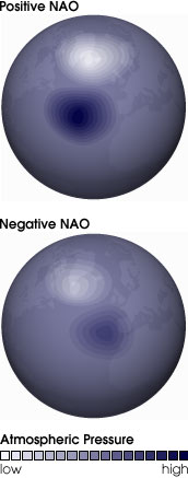
The NAO has multiple possible definitions. The easiest to understand are those based on measuring the seasonal average air pressure difference between stations, such as:- Lisbon, Portugal and Stykkisholmur/Reykjavik, Iceland
- Ponta Delgada, Azores and Stykkisholmur/Reykjavik, Iceland
- Azores (1865–2002), Gibraltar (1821–2007), and Reykjavik, Iceland
These definitions all have in common the same northern point (because this is the only station in the region with a long record) in Iceland; and various southern points. All are attempting to capture the same pattern of variation, by choosing stations in the "eye" of the two stable pressure areas: The Azores high
Azores High
The Azores High is a large subtropical semi-permanent centre of high atmospheric pressure found near the Azores in the Atlantic Ocean, at the Horse latitudes...
and the Icelandic low
Icelandic Low
The Icelandic Low is a semi-permanent centre of low atmospheric pressure found between Iceland and southern Greenland and extending in the Northern Hemisphere winter into the Barents Sea. In summer it weakens and splits into two centres, one near Davis Strait and the other west of Iceland...
(shown in the graphic).
A more complex definition, only possible with more complete modern records generated by numerical weather prediction
Numerical weather prediction
Numerical weather prediction uses mathematical models of the atmosphere and oceans to predict the weather based on current weather conditions. Though first attempted in the 1920s, it was not until the advent of computer simulation in the 1950s that numerical weather predictions produced realistic...
, is based on the principal empirical orthogonal function (EOF) of surface pressure. This definition has a high degree of correlation with the station-based definition. This then leads onto a debate as to whether the NAO is distinct from the AO/NAM, and if not, which of the two is to be considered the most physically based expression of atmospheric structure (as opposed to the one that most clearly falls out of mathematical expression).
Description
Westerly winds blowing across the Atlantic bring moist air into EuropeEurope
Europe is, by convention, one of the world's seven continents. Comprising the westernmost peninsula of Eurasia, Europe is generally 'divided' from Asia to its east by the watershed divides of the Ural and Caucasus Mountains, the Ural River, the Caspian and Black Seas, and the waterways connecting...
. In years when westerlies
Westerlies
The Westerlies, anti-trades, or Prevailing Westerlies, are the prevailing winds in the middle latitudes between 30 and 60 degrees latitude, blowing from the high pressure area in the horse latitudes towards the poles. These prevailing winds blow from the west to the east, and steer extratropical...
are strong, summers are cool, winters are mild and rain
Rain
Rain is liquid precipitation, as opposed to non-liquid kinds of precipitation such as snow, hail and sleet. Rain requires the presence of a thick layer of the atmosphere to have temperatures above the melting point of water near and above the Earth's surface...
is frequent. If westerlies are suppressed, the temperature is more extreme in summer and winter leading to heatwaves, deep freezes and reduced rainfall.
A permanent low-pressure system over Iceland
Iceland
Iceland , described as the Republic of Iceland, is a Nordic and European island country in the North Atlantic Ocean, on the Mid-Atlantic Ridge. Iceland also refers to the main island of the country, which contains almost all the population and almost all the land area. The country has a population...
(the Icelandic Low) and a permanent high-pressure system over the Azores
Azores
The Archipelago of the Azores is composed of nine volcanic islands situated in the middle of the North Atlantic Ocean, and is located about west from Lisbon and about east from the east coast of North America. The islands, and their economic exclusion zone, form the Autonomous Region of the...
(the Azores High) control the direction and strength of westerly winds into Europe. The relative strengths and positions of these systems vary from year to year and this variation is known as the NAO. A large difference in the pressure at the two stations (a high index year, denoted NAO+) leads to increased westerlies and, consequently, cool summers and mild and wet winters in Central Europe and its Atlantic facade. In contrast, if the index is low (NAO-), westerlies are suppressed, these areas suffer cold winters and storms track southerly toward the Mediterranean Sea
Mediterranean Sea
The Mediterranean Sea is a sea connected to the Atlantic Ocean surrounded by the Mediterranean region and almost completely enclosed by land: on the north by Anatolia and Europe, on the south by North Africa, and on the east by the Levant...
. This brings increased storm activity and rainfall to southern Europe and North Africa
North Africa
North Africa or Northern Africa is the northernmost region of the African continent, linked by the Sahara to Sub-Saharan Africa. Geopolitically, the United Nations definition of Northern Africa includes eight countries or territories; Algeria, Egypt, Libya, Morocco, South Sudan, Sudan, Tunisia, and...
.
Especially during the months of November to April, the NAO is responsible for much of the variability of weather in the North Atlantic region, affecting wind speed and wind direction changes, changes in temperature and moisture distribution and the intensity, number and track of storms.
Although having a less direct influence than for Western Europe, the NAO is also believed to have an impact on the weather over much of eastern North America. During the winter, when the index is high (NAO+), the Icelandic low draws a stronger south-westerly circulation over the eastern half of the North American continent which prevents Arctic air from plunging southward. In combination with the El Niño, this effect can produce significantly warmer winters over the northeastern United States
Northeastern United States
The Northeastern United States is a region of the United States as defined by the United States Census Bureau.-Composition:The region comprises nine states: the New England states of Connecticut, Maine, Massachusetts, New Hampshire, Rhode Island and Vermont; and the Mid-Atlantic states of New...
and southeastern Canada
Canada
Canada is a North American country consisting of ten provinces and three territories. Located in the northern part of the continent, it extends from the Atlantic Ocean in the east to the Pacific Ocean in the west, and northward into the Arctic Ocean...
. Conversely, when the NAO index is low (NAO-), these areas can incur winter temperatures significantly colder than the norm.
Effects on North Atlantic sea level
Under a positive NAO index (NAO+), regional reduction in atmospheric pressure results in a regional rise in sea level due to the 'inverse barometer effect'. This effect is important to both the interpretation of historic sea level records and predictions of future sea level trends, as mean pressure fluctuations of the order of milibars can lead to sea level fluctuations of the order of centimeters.North Atlantic hurricanes
By controlling the position of the Azores high, the NAO also influences the direction of general storm paths for major North Atlantic tropical cyclones: a position of the Azores high farther to the south tends to force storms into the Gulf of MexicoGulf of Mexico
The Gulf of Mexico is a partially landlocked ocean basin largely surrounded by the North American continent and the island of Cuba. It is bounded on the northeast, north and northwest by the Gulf Coast of the United States, on the southwest and south by Mexico, and on the southeast by Cuba. In...
, whereas a northern position allows them to track up the North American Atlantic Coast.
As paleotempestological
Paleotempestology
Paleotempestology is the study of past tropical cyclone activity by means of geological proxies as well as historical documentary records. The term was coined by Kerry Emanuel.-Sedimentary proxy records:...
research has shown, few major hurricanes struck the Gulf coast during 3000–1400 BC and again during the most recent millennium. These quiescent intervals were separated by a hyperactive period during 1400 BC and 1000 AD, when the Gulf coast was struck frequently by catastrophic hurricanes and their landfall probabilities increased by 3–5 times.
Ecological effects
The NAO has been in an overall more positive regime since the late 1970s, bringing colder conditions to the North-West Atlantic, which has been linked with the thriving populations of Labrador SeaLabrador Sea
The Labrador Sea is an arm of the North Atlantic Ocean between the Labrador Peninsula and Greenland. The sea is flanked by continental shelves to the southwest, northwest, and northeast. It connects to the north with Baffin Bay through the Davis Strait...
snow crabs, which have a low temperature optimum.
The NAO+ warming of the North Sea
North Sea
In the southwest, beyond the Straits of Dover, the North Sea becomes the English Channel connecting to the Atlantic Ocean. In the east, it connects to the Baltic Sea via the Skagerrak and Kattegat, narrow straits that separate Denmark from Norway and Sweden respectively...
reduces survival of cod
Cod
Cod is the common name for genus Gadus, belonging to the family Gadidae, and is also used in the common name for various other fishes. Cod is a popular food with a mild flavor, low fat content and a dense, flaky white flesh. Cod livers are processed to make cod liver oil, an important source of...
larvae which are at the upper limits of their temperature tolerance, as does the cooling in the Labrador Sea, where the cod larvae are at their lower temperature limits. Though not the critical factor, the NAO+ peak in the early 1990s may have contributed to the collapse of the Newfoundland cod fishery
Cod fishing in Newfoundland
Cod fishing in Newfoundland was carried out at a subsistence level for centuries, but large scale fishing began shortly after the European discovery of the North American continent in 1492, with the waters being found to be preternaturally plentiful, and ended after intense overfishing with the...
.
On the East Coast of the United States
East Coast of the United States
The East Coast of the United States, also known as the Eastern Seaboard, refers to the easternmost coastal states in the United States, which touch the Atlantic Ocean and stretch up to Canada. The term includes the U.S...
an NAO+ causes warmer temperatures and increased rainfall, and thus warmer, less saline
Salinity
Salinity is the saltiness or dissolved salt content of a body of water. It is a general term used to describe the levels of different salts such as sodium chloride, magnesium and calcium sulfates, and bicarbonates...
surface water. This prevents nutrient-rich upwelling
Upwelling
Upwelling is an oceanographic phenomenon that involves wind-driven motion of dense, cooler, and usually nutrient-rich water towards the ocean surface, replacing the warmer, usually nutrient-depleted surface water. The increased availability in upwelling regions results in high levels of primary...
which has reduced productivity. Georges Bank
Georges Bank
Georges Bank is a large elevated area of the sea floor which separates the Gulf of Maine from the Atlantic Ocean and is situated between Cape Cod, Massachusetts and Cape Sable Island, Nova Scotia ....
and the Gulf of Maine
Gulf of Maine
The Gulf of Maine is a large gulf of the Atlantic Ocean on the east coast of North America.It is delineated by Cape Cod at the eastern tip of Massachusetts in the southwest and Cape Sable at the southern tip of Nova Scotia in the northeast. It includes the entire coastlines of the U.S...
are affected by this reduced cod catch.
The strength of the NAO is also a determinant in the population fluctuations of the intensively studied Soay sheep
Soay sheep
The Soay sheep is a primitive breed of domestic sheep descended from a population of feral sheep on the island of Soay in the St. Kilda Archipelago, about from the Western Isles of Scotland...
.
Winter of 2009-10 in Europe
The winter of 2009-10 in Europe was unusually cold, especially during December, January and February. It is theorized that this may be due to solar activity. The Met OfficeMet Office
The Met Office , is the United Kingdom's national weather service, and a trading fund of the Department for Business, Innovation and Skills...
reported that the UK
United Kingdom
The United Kingdom of Great Britain and Northern IrelandIn the United Kingdom and Dependencies, other languages have been officially recognised as legitimate autochthonous languages under the European Charter for Regional or Minority Languages...
, for example, had experienced its coldest winter for 30 years. This coincided with an exceptionally negative phase of the NAO. Analysis published in mid-2010 suggests it was caused by a freak combination of an 'El Nino' event and the rare occurrence of an extremely negative NAO.
However, during the winter of 2010-11 in Northern and Western Europe
Winter of 2010–2011 in Europe
The winter of 2010-2011 in Europe began with an unusually cold November caused by a cold weather cycle that started in southern Scandinavia and subsequently moved south and west over both Belgium and the Netherlands on 25 November and into the west of Scotland and north east England on 26 November...
, the Icelandic low
Icelandic Low
The Icelandic Low is a semi-permanent centre of low atmospheric pressure found between Iceland and southern Greenland and extending in the Northern Hemisphere winter into the Barents Sea. In summer it weakens and splits into two centres, one near Davis Strait and the other west of Iceland...
, typically positioned west of Iceland and east of Greenland, appeared regularly to the east of Iceland and so allowed exceptionally cold air into Europe from the Arctic. A strong area of high pressure was initially situated over Greenland
Greenland
Greenland is an autonomous country within the Kingdom of Denmark, located between the Arctic and Atlantic Oceans, east of the Canadian Arctic Archipelago. Though physiographically a part of the continent of North America, Greenland has been politically and culturally associated with Europe for...
, reversing the normal wind pattern in the northwestern Atlantic, creating a block
Block (meteorology)
Blocks in meteorology are large scale patterns in the atmospheric pressure field that are nearly stationary, effectively "blocking" or redirecting migratory cyclones. They are also known as blocking highs or blocking anticyclones...
ing pattern driving warm air into northeastern Canada and cold air into Western Europe, as was the case during the previous winter. This occurred during a La Niña season, and is connected to the rare Arctic dipole anomaly
Arctic dipole anomaly
The Arctic dipole anomaly is a pressure pattern characterized by high pressure on the arctic regions of North America, and a low pressure on the Eurasia region. This pattern sometimes replaces the Arctic oscillation and the North Atlantic Oscillation. It was observed for the first time in the...
.
See also
- Arctic oscillationArctic oscillationThe Arctic oscillation or Northern Annular Mode/Northern Hemisphere Annular Mode is an index of the dominant pattern of non-seasonal sea-level pressure variations north of 20N latitude, and it is characterized by pressure anomalies of one sign in the Arctic with the opposite anomalies centered...
- Antarctic oscillationAntarctic oscillationThe Antarctic oscillation is a low-frequency mode of atmospheric variability of the southern hemisphere...
- Atlantic OceanAtlantic OceanThe Atlantic Ocean is the second-largest of the world's oceanic divisions. With a total area of about , it covers approximately 20% of the Earth's surface and about 26% of its water surface area...
- AnticycloneAnticycloneAn anticyclone is a weather phenomenon defined by the United States' National Weather Service's glossary as "[a] large-scale circulation of winds around a central region of high atmospheric pressure, clockwise in the Northern Hemisphere, counterclockwise in the Southern Hemisphere"...
- El Niño / Southern Oscillation Index
- Global warmingGlobal warmingGlobal warming refers to the rising average temperature of Earth's atmosphere and oceans and its projected continuation. In the last 100 years, Earth's average surface temperature increased by about with about two thirds of the increase occurring over just the last three decades...
- Latitude of the Gulf Stream and the Gulf Stream north wall indexLatitude of the Gulf Stream and the Gulf Stream north wall indexThe Gulf Stream separates from the US coast near Cape Hatteras and then travels eastwards across the North Atlantic, becoming the North Atlantic current at about 55oW. In the region between 75oW and 55oW it is subject to meanders and is frequently accompanied by eddies. The northern edge of the...
- Pacific decadal oscillationPacific decadal oscillationThe Pacific Decadal Oscillation is a pattern of Pacific climate variability that shifts phases on at least inter-decadal time scale, usually about 20 to 30 years. The PDO is detected as warm or cool surface waters in the Pacific Ocean, north of 20° N...
- Pacific-North American teleconnection patternPacific-North American teleconnection patternThe Pacific-North American teleconnection pattern is a climatological term for a large-scale weather pattern with two modes, denoted positive and negative, and which relates the atmospheric circulation pattern over the North Pacific Ocean with the one over the North American continent.The positive...
- North Atlantic CurrentNorth Atlantic CurrentThe North Atlantic Current is a powerful warm ocean current that continues the Gulf Stream northeast. West of Ireland it splits in two; one branch, the Canary Current, goes south, while the other continues north along the coast of northwestern Europe...
- North Atlantic GyreNorth Atlantic GyreThe North Atlantic Gyre, located in the Atlantic Ocean, is one of the five major oceanic gyres. It includes the Gulf Stream and contains the Sargasso Sea. This gyre is similar to the North Pacific Gyre in the way it traps man-made ocean debris in the North Atlantic Garbage Patch, similar to the...
External links
- Current NAO observations and forecasts
- UK's climatic research unit information sheet on the NAO
- Overview paper on the NAO from the USA's National Center for Atmospheric Research Hurrell at al, ~2002, 35pp
- The North Atlantic Oscillation by Martin Visbeck
- Overview of Climate Indices
- Heavy January snowfall caused by freak 'weather collision'