

Ice core
Encyclopedia

Core sample
A core sample is a cylindrical section of a naturally occurring substance. Most core samples are obtained by drilling with special drills into the substance, for example sediment or rock, with a hollow steel tube called a core drill. The hole made for the core sample is called the "core hole". A...
that is typically removed from an ice sheet
Ice sheet
An ice sheet is a mass of glacier ice that covers surrounding terrain and is greater than 50,000 km² , thus also known as continental glacier...
, most commonly from the polar ice caps of Antarctica, Greenland
Greenland
Greenland is an autonomous country within the Kingdom of Denmark, located between the Arctic and Atlantic Oceans, east of the Canadian Arctic Archipelago. Though physiographically a part of the continent of North America, Greenland has been politically and culturally associated with Europe for...
or from high mountain glacier
Glacier
A glacier is a large persistent body of ice that forms where the accumulation of snow exceeds its ablation over many years, often centuries. At least 0.1 km² in area and 50 m thick, but often much larger, a glacier slowly deforms and flows due to stresses induced by its weight...
s elsewhere. As the ice
Ice
Ice is water frozen into the solid state. Usually ice is the phase known as ice Ih, which is the most abundant of the varying solid phases on the Earth's surface. It can appear transparent or opaque bluish-white color, depending on the presence of impurities or air inclusions...
forms from the incremental build up of annual layers of snow
Snow
Snow is a form of precipitation within the Earth's atmosphere in the form of crystalline water ice, consisting of a multitude of snowflakes that fall from clouds. Since snow is composed of small ice particles, it is a granular material. It has an open and therefore soft structure, unless packed by...
, lower layers are older than upper, and an ice core contains ice formed over a range of years. The properties of the ice and the recrystallized
Recrystallization (chemistry)
-Chemistry:In chemistry, recrystallization is a procedure for purifying compounds. The most typical situation is that a desired "compound A" is contaminated by a small amount of "impurity B". There are various methods of purification that may be attempted , which includes recrystallization...
inclusions within the ice can then be used to reconstruct a climatic record over the age range of the core, normally through isotopic analysis
Isotope
Isotopes are variants of atoms of a particular chemical element, which have differing numbers of neutrons. Atoms of a particular element by definition must contain the same number of protons but may have a distinct number of neutrons which differs from atom to atom, without changing the designation...
. This enables the reconstruction of local temperature records and the history of atmospheric composition.
Ice cores contain an abundance of climate
Climate
Climate encompasses the statistics of temperature, humidity, atmospheric pressure, wind, rainfall, atmospheric particle count and other meteorological elemental measurements in a given region over long periods...
information. Inclusions in the snow of each year remain in the ice, such as wind-blown dust
Dust
Dust consists of particles in the atmosphere that arise from various sources such as soil dust lifted up by wind , volcanic eruptions, and pollution...
, ash
Volcanic ash
Volcanic ash consists of small tephra, which are bits of pulverized rock and glass created by volcanic eruptions, less than in diameter. There are three mechanisms of volcanic ash formation: gas release under decompression causing magmatic eruptions; thermal contraction from chilling on contact...
, bubbles of atmospheric gas and radioactive substances. The variety of climatic proxies
Proxy (climate)
In the study of past climates is known as paleoclimatology, climate proxies are preserved physical characteristics of the past that stand in for direct measurements , to enable scientists to reconstruct the climatic conditions that prevailed during much of the Earth's history...
is greater than in any other natural recorder of climate, such as tree rings or sediment layers
Varve
A varve is an annual layer of sediment or sedimentary rock.The word 'varve' is derived from the Swedish word varv whose meanings and connotations include 'revolution', 'in layers', and 'circle'. The term first appeared as Hvarfig lera on the first map produced by the Geological Survey of Sweden in...
. These include (proxies for) temperature, ocean volume, precipitation, chemistry and gas composition of the lower atmosphere, volcanic eruptions, solar variability, sea-surface productivity, desert extent and forest fires.
The length of the record depends on the depth of the ice core and varies from a few years up to 800 kyr
Kyr
The symbol kyr was formerly common in some English-language works, especially in geology and astronomy, for the unit of one thousand years or millennium. The "k" is the unit prefix for kilo- or thousand with the suffix "yr" simply an abbreviation for "year"....
for the EPICA core. The time resolution (i.e. the shortest time period which can be accurately distinguished) depends on the amount of annual snowfall, and reduces with depth as the ice compacts under the weight of layers accumulating on top of it. Upper layers of ice in a core correspond to a single year or sometimes a single season. Deeper into the ice the layers thin and annual layers become indistinguishable.
An ice core from the right site can be used to reconstruct an uninterrupted and detailed climate record extending over hundreds of thousands of years, providing information on a wide variety of aspects of climate at each point in time. It is the simultaneity of these properties recorded in the ice that makes ice cores such a powerful tool in paleoclimate research.
Structure of ice sheets and cores
The surface layer is snow in various forms, with air gaps between snowflakes. As snow continues to accumulate, the buried snow is compressed and forms firn
Firn
Firn is partially-compacted névé, a type of snow that has been left over from past seasons and has been recrystallized into a substance denser than névé. It is ice that is at an intermediate stage between snow and glacial ice...
, a grainy material with a texture similar to granulated sugar. Air gaps remain, and some circulation of air continues. As snow accumulates above, the firn continues to densify, and at some point the pores close off and the air is trapped. Because the air continues to circulate until then, the ice age and the age of the gas enclosed are not the same, and may differ by hundreds of years. The gas age–ice age difference is as great as 7 kyr in glacial ice from Vostok.
Under increasing pressure, at some depth the firn is compressed into ice. This depth may range between a few to several tens of meters to typically 100 m for Antarctic cores. Below this level material is frozen in the ice. Ice may appear clear or blue.
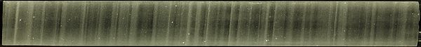
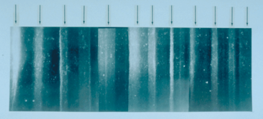
Layers can be visually distinguished in firn and in ice to significant depths. In a location on the summit of an ice sheet where there is little flow, accumulation tends to move down and away, creating layers with minimal disturbance. In a location where underlying ice is flowing, deeper layers may have increasingly different characteristics and distortion. Drill cores near bedrock often are challenging to analyze due to distorted flow patterns and composition likely to include materials from the underlying surface.
Characteristics of firn
The layer of porous firn on Antarctic ice sheets is 50–150 m deep.It is much less deep on glaciers.
Air in the atmosphere and firn
Firn
Firn is partially-compacted névé, a type of snow that has been left over from past seasons and has been recrystallized into a substance denser than névé. It is ice that is at an intermediate stage between snow and glacial ice...
are slowly exchanged by molecular diffusion through pore spaces, because gases move toward regions of lower concentration. Thermal diffusion causes isotope fractionation in firn when there is rapid temperature variation, creating isotope differences which are captured in bubbles when ice is created at the base of firn.
There is gas movement due to diffusion in firn, but not convection except very near the surface.
Below the firn is a zone in which seasonal layers alternately have open and closed porosity. These layers are sealed with respect to diffusion. Gas ages increase rapidly with depth in these layers. Various gases are fractionated while bubbles are trapped where firn is converted to ice.
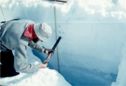
Coring
A core is collected by separating it from the surrounding material. For material which is sufficiently soft, coring may be done with a hollow tube. Deep core drilling into hard ice, and perhaps underlying bedrock, involves using a hollow drill which actively cuts a cylindrical pathway downward around the core.When a drill is used, the cutting apparatus is on the bottom end of a drill barrel, the tube which surrounds the core as the drill cuts downward around the edge of the cylindrical core. The length of the drill barrel determines the maximum length of a core sample (6 m at GISP2 and Vostok). Collection of a long core record thus requires many cycles of lowering a drill/barrel assembly, cutting a core 4–6 m in length, raising the assembly to the surface, emptying the core barrel, and preparing a drill/barrel for drilling.
Because deep ice is under pressure and can deform, for cores deeper than about 300 m the hole will tend to close if there is nothing to supply back pressure. The hole is filled with a fluid to keep the hole from closing. The fluid, or mixture of fluids, must simultaneously satisfy criteria for density, low viscosity, frost resistance, as well as workplace safety and environmental compliance. The fluid must also satisfy other criteria, for example those stemming from the analytical methods employed on the ice core. A number of different fluids and fluid combinations have been tried in the past. Since GISP
Greenland Ice Sheet Project
The Greenland Ice Sheet Project was a decade-long project to drill ice cores in Greenland that involved scientists and funding agencies from Denmark, Switzerland and the United States. Besides the U.S. National Science Foundation, funding was provided by the Swiss National Science Foundation and...
2 (1990–1993) the US Polar Program has utilized a single-component fluid system, n-butyl acetate, but the toxicology, flammability, aggressive solvent nature, and longterm liabilities of n-butyl acetate raises serious questions about its continued application. The European community, including the Russian program, has concentrated on the use of two-component drilling fluid consisting of low-density hydrocarbon base (brown kerosene
Kerosene
Kerosene, sometimes spelled kerosine in scientific and industrial usage, also known as paraffin or paraffin oil in the United Kingdom, Hong Kong, Ireland and South Africa, is a combustible hydrocarbon liquid. The name is derived from Greek keros...
was used at Vostok) boosted to the density of ice by addition of halogenated-hydrocarbon densifier. Many of the proven densifier products are now considered too toxic, or are no longer available due to efforts to enforce the Montreal Protocol
Montreal Protocol
The Montreal Protocol on Substances That Deplete the Ozone Layer is an international treaty designed to protect the ozone layer by phasing out the production of numerous substances believed to be responsible for ozone depletion...
on ozone-depleting substances. In April 1998 on the Devon Ice Cap
Devon Ice Cap
The Devon Ice Cap is an ice cap on eastern Devon Island covering an area of over . The highest point on Devon Island is found at the summit of the ice cap, with an elevation of . The ice cap has a maximum thickness of ....
filtered lamp oil was used as a drilling fluid. In the Devon core it was observed that below about 150 m the stratigraphy
Stratigraphy
Stratigraphy, a branch of geology, studies rock layers and layering . It is primarily used in the study of sedimentary and layered volcanic rocks....
was obscured by microfractures.
Core processing

The core is carefully extruded from the barrel; often facilities are designed to accommodate the entire length of the core on a horizontal surface. Drilling fluid will be cleaned off before the core is cut into 1-2 meter sections. Various measurements may be taken during preliminary core processing.
Current practices to avoid contamination of ice include:
- Keeping ice well below the freezing point.
- At Greenland and Antarctic sites, temperature is maintained by having storage and work areas under the snow/ice surface.
- At GISP2, cores were never allowed to rise above -15 °C, partly to prevent microcracks from forming and allowing present-day air to contaminate the fossil air trapped in the ice fabric, and partly to inhibit recrystallization of the ice structure.
- Wearing special clean suits over cold weather clothing.
- Mittens or gloves.
- Filtered respirators.
- Plastic bags, often polyethylenePolyethylenePolyethylene or polythene is the most widely used plastic, with an annual production of approximately 80 million metric tons...
, around ice cores. Some drill barrels include a liner. - Proper cleaning of tools and laboratory equipment.
- Use of laminar-flow bench to isolate core from room particulates.
For shipping, cores are packed in Styrofoam
Styrofoam
Styrofoam is a trademark of The Dow Chemical Company for closed-cell currently made for thermal insulation and craft applications. In 1941, researchers in Dow's Chemical Physics Lab found a way to make foamed polystyrene...
boxes protected by shock absorbing bubble-wrap.
Due to the many types of analysis done on core samples, sections of the core are scheduled for specific uses. After the core is ready for further analysis, each section is cut as required for tests. Some testing is done on site, other study will be done later, and a significant fraction of each core segment is reserved for archival storage for future needs.
Projects have used different core-processing strategies. Some projects have only done studies of physical properties in the field, while others have done significantly more study in the field. These differences are reflected in the core processing facilities.
Ice relaxation
Deep ice is under great pressure. When brought to the surface, there is a drastic change in pressure. Due to the internal pressure and varying composition, particularly bubbles, sometimes cores are very brittleBrittle
A material is brittle if, when subjected to stress, it breaks without significant deformation . Brittle materials absorb relatively little energy prior to fracture, even those of high strength. Breaking is often accompanied by a snapping sound. Brittle materials include most ceramics and glasses ...
and can break or shatter during handling. At Dome C, the first 1000 m were brittle ice. Siple dome encountered it from 400 to 1000 m. It has been found that allowing ice cores to rest for some time (sometimes for a year) makes them become much less brittle.
Decompression causes significant volume expansion (called relaxation) due to microcracking and the exsolving of enclathratized
Clathrate hydrate
Clathrate hydrates are crystalline water-based solids physically resembling ice, in which small non-polar molecules or polar molecules with large hydrophobic moieties are trapped inside "cages" of hydrogen bonded water molecules...
gases. Relaxation may last for months. During this time, ice cores are stored below -10 °C to prevent cracking due to expansion at higher temperatures. At drilling sites, a relaxation area is often built within existing ice at a depth which allows ice core storage at temperatures below -20 °C.
It has been observed that the internal structure of ice undergoes distinct changes during relaxation. Changes include much more pronounced cloudy bands and much higher density of "white patches" and bubbles.
Several techniques have been examined. Cores obtained by hot water drilling at Siple Dome
Siple Dome
Siple Dome is an ice dome approximately 100 km wide and 100 km long, located 130 km east of Siple Coast. Charles Bentley and Robert Thomas established a "strain rosette" on this feature to determine ice movement in 1973-74. They referred to the feature as Siple Dome because of its...
in 1997–1998 underwent appreciably more relaxation than cores obtained with the PICO electro-mechanical drill. In addition, the fact that cores were allowed to remain at the surface at elevated temperature for several days likely promoted the onset of rapid relaxation.
Ice core data
Many materials can appear in an ice core. Layers can be measured in several ways to identify changes in composition. Small meteorites may be embedded in the ice. Volcanic eruptions leave identifiable ash layers. Dust in the core can be linked to increased desert area or wind speed.Isotopic analysis of the ice in the core can be linked to temperature and global sea level variations. Analysis of the air contained in bubbles
Fluid inclusions
thumb|250px|Trapped in a time capsule the same size as the diameter of a human hair, the ore-forming liquid in this inclusion was so hot and contained so much dissolved solids that when it cooled, crystals of halite, sylvite, gypsum, and hematite formed. As the samples cooled, the fluid shrank more...
in the ice can reveal the palaeocomposition of the atmosphere, in particular CO2 variations. There are great problems relating the dating of the included bubbles to the dating of the ice, since the bubbles only slowly "close off" after the ice has been deposited. Nonetheless, recent work has tended to show that during deglaciations CO2 increases lags temperature increases by 600 +/- 400 years. Beryllium-10
Beryllium-10
Beryllium-10 is a radioactive isotope of beryllium. It is formed mainly by cosmic ray spallation. Be-10 has a half-life of 1.36 × 10⁶ years, and decays by beta decay to stable Boron-10 with a maximum energy of 556.2 keV....
concentrations are linked to cosmic ray intensity which can be a proxy
Proxy (climate)
In the study of past climates is known as paleoclimatology, climate proxies are preserved physical characteristics of the past that stand in for direct measurements , to enable scientists to reconstruct the climatic conditions that prevailed during much of the Earth's history...
for solar strength.
There may be an association between atmospheric nitrates in ice and solar activity. However, recently it was discovered that sunlight triggers chemical changes within top levels of firn which significantly alter the pore air composition. This raises levels of formaldehyde
Formaldehyde
Formaldehyde is an organic compound with the formula CH2O. It is the simplest aldehyde, hence its systematic name methanal.Formaldehyde is a colorless gas with a characteristic pungent odor. It is an important precursor to many other chemical compounds, especially for polymers...
and NOx
NOx
NOx is a generic term for the mono-nitrogen oxides NO and NO2 . They are produced from the reaction of nitrogen and oxygen gases in the air during combustion, especially at high temperatures...
. Although the remaining levels of nitrates may indeed be indicators of solar activity, there is ongoing investigation of resulting and related effects of effects upon ice core data.
Core contamination
Some contamination has been detected in ice cores. The levels of lead on the outside of ice cores is much higher than on the inside. In ice from the Vostok core (Antarctica), the outer portion of the cores have up to 3 and 2 orders of magnitude higher bacterial density and dissolved organic carbon than the inner portion of the cores, respectively, as a result of drilling and handling.Paleoatmospheric sampling
As porous snow consolidates into ice, the air within it is trapped in bubbles in the ice. This process continuously preserves samples of the atmosphere. In order to retrieve these natural samples the ice is ground at low temperatures, allowing the trapped air to escape. It is then condensed for analysis by gas chromatography or mass spectrometryMass spectrometry
Mass spectrometry is an analytical technique that measures the mass-to-charge ratio of charged particles.It is used for determining masses of particles, for determining the elemental composition of a sample or molecule, and for elucidating the chemical structures of molecules, such as peptides and...
, revealing gas concentrations and their isotopic composition respectively. Apart from the intrinsic importance of knowing relative gas concentrations (e.g. to estimate the extent of greenhouse warming), their isotopic composition can provide information on the sources of gases. For example CO2 from fossil-fuel or biomass burning is relatively depleted in 13C. See Friedli et al., 1986.
Dating the air with respect to the ice it is trapped in is problematic. The consolidation of snow to ice necessary to trap the air takes place at depth (the 'trapping depth') once the pressure of overlying snow is great enough. Since air can freely diffuse from the overlying atmosphere throughout the upper unconsolidated layer (the 'firn'), trapped air is younger than the ice surrounding it.
Trapping depth varies with climatic conditions, so the air-ice age difference could vary between 2500 and 6000 years (Barnola et al., 1991). However, air from the overlying atmosphere may not mix uniformly throughout the firn (Battle et al., 1986) as earlier assumed, meaning estimates of the air-ice age difference could be less than imagined. Either way, this age difference is a critical uncertainty in dating ice-core air samples. In addition, gas movement would be different for various gases; for example, larger molecules would be unable to move at a different depth than smaller molecules so the ages of gases at a certain depth may be different. Some gases also have characteristics which affect their inclusion, such as helium
Helium
Helium is the chemical element with atomic number 2 and an atomic weight of 4.002602, which is represented by the symbol He. It is a colorless, odorless, tasteless, non-toxic, inert, monatomic gas that heads the noble gas group in the periodic table...
not being trapped because it is soluble in ice.
In Law Dome ice cores, the trapping depth at DE08 was found to be 72 m where the age of the ice is 40±1 years; at DE08-2 to be 72 m depth and 40 years; and at DSS to be 66 m depth and 68 years.
Paleoatmospheric firn studies
Gases involved in ozone depletion
Ozone depletion
Ozone depletion describes two distinct but related phenomena observed since the late 1970s: a steady decline of about 4% per decade in the total volume of ozone in Earth's stratosphere , and a much larger springtime decrease in stratospheric ozone over Earth's polar regions. The latter phenomenon...
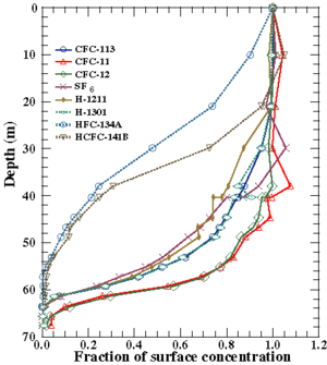
, CFCs, chlorocarbons, and bromocarbons, were measured in firn and levels were almost zero at around 1880 except for CH3Br, which is known to have natural sources. Similar study of Greenland firn found that CFCs vanished at a depth of 69 m (CO2 age of 1929).
Upper Fremont Glacier
Upper Fremont Glacier is located in the Fitzpatrick Wilderness of Shoshone National Forest in the U.S. state of Wyoming. This Wind River Range glacier is associated with the largest grouping of glaciers in the U.S. Rocky Mountains and lies on the north slope of Fremont Peak, the third tallest...
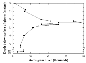
ice core showed large levels of chlorine
Chlorine
Chlorine is the chemical element with atomic number 17 and symbol Cl. It is the second lightest halogen, found in the periodic table in group 17. The element forms diatomic molecules under standard conditions, called dichlorine...
-36 that definitely correspond to the production of that isotope during atmospheric testing of nuclear weapon
Nuclear weapon
A nuclear weapon is an explosive device that derives its destructive force from nuclear reactions, either fission or a combination of fission and fusion. Both reactions release vast quantities of energy from relatively small amounts of matter. The first fission bomb test released the same amount...
s. This result is interesting because the signal exists despite being on a glacier and undergoing the effects of thawing, refreezing, and associated meltwater percolation. 36Cl has also been detected in the Dye-3 ice core (Greenland), and in firn at Vostok.
Studies of gases in firn often involve estimates of changes in gases due to physical processes such as diffusion. However, it has been noted that there also are populations of bacteria in surface snow and firn at the South Pole, although this study has been challenged. It had previously been pointed out that anomalies in some trace gases may be explained as due to accumulation of in-situ metabolic trace gas byproducts.
Dating cores
Hydrogen
Hydrogen is the chemical element with atomic number 1. It is represented by the symbol H. With an average atomic weight of , hydrogen is the lightest and most abundant chemical element, constituting roughly 75% of the Universe's chemical elemental mass. Stars in the main sequence are mainly...
and O
Oxygen
Oxygen is the element with atomic number 8 and represented by the symbol O. Its name derives from the Greek roots ὀξύς and -γενής , because at the time of naming, it was mistakenly thought that all acids required oxygen in their composition...
). Deeper into the core the layers thin out due to ice flow and high pressure and eventually individual years cannot be distinguished. It may be possible to identify events such as nuclear bomb atmospheric testing's radioisotope layers in the upper levels, and ash layers corresponding to known volcanic eruptions. Volcanic eruptions may be detected by visible ash layers, acidic chemistry, or electrical resistance change. Some composition changes are detected by high-resolution scans of electrical resistance. Lower down the ages are reconstructed by modeling accumulation rate variations and ice flow.
Dating is a difficult task. Five different dating methods have been used for Vostok cores, with differences such as 300 years at 100 m depth, 600yr at 200 m, 7000yr at 400 m, 5000yr at 800 m, 6000yr at 1600 m, and 5000yr at 1934 m.
Different dating methods makes comparison and interpretation difficult. Matching peaks by visual examination of Moulton and Vostok ice cores suggests a time difference of about 10,000 years but proper interpretation requires knowing the reasons for the differences.
Ice core storage and transport
Ice cores are typically stored and transported in refrigerated ISO container systems. Due to the high value and the temperature-sensitive nature of the ice core samples, container systems with primary and back-up refrigeration units and generator sets are often used. Known as a Redundant Container System in the industry, the refrigeration unit and generator set automatically switches to its back-up in the case of a loss of performance or power to provide the ultimate peace of mind when shipping this valuable cargo.Ice core sites
Ice cores have been taken from many locations around the world. Major efforts have taken place on Greenland and Antarctica.Sites on Greenland are more susceptible to snow melt than those in Antarctica. In the Antarctic, areas around the Antarctic Peninsula
Antarctic Peninsula
The Antarctic Peninsula is the northernmost part of the mainland of Antarctica. It extends from a line between Cape Adams and a point on the mainland south of Eklund Islands....
and seas to the west have been found to be affected by ENSO
Enso
Ensō is a Japanese word meaning "circle" and a concept strongly associated with Zen. Ensō is one of the most common subjects of Japanese calligraphy even though it is a symbol and not a character. It symbolizes the Absolute enlightenment, strength, elegance, the Universe, and the void; it can...
effects. Both of these characteristics have been used to study such variations over long spans of time.
Greenland
The first to winter on the inland ice was J.P. Koch and Alfred Wegener in a hut they built on the ice in Northeast Greenland. Inside the hut they drilled to a depth of 25 m with an auger similar to an oversized corkscrew.Station Eismitte
Eismitte means Ice-Center in German. The Greenland campsite was located 402 kilometres (249.8 mi) from the coast at an estimated altitude of 3,000 meters (9,843 feet).As a member of the Alfred Wegener Expedition to Eismitte in central Greenland from July 1930 to August 1931, Ernst Sorge hand-dug a 15 m deep pit adjacent to his beneath-the-surface snow cave. Sorge was the first to systematically and quantitatively study the near-surface snow/firn strata from inside his pit. His research validated the feasibility of measuring the preserved annual snow accumulation cycles, like measuring frozen precipitation in a rain gauge.
Camp VI
During 1950-1951 members of Expeditions Polaires Francaises (EPF) led by Paul Emile Victor reported boring two holes to depths of 126 and 150 m on the central Greenland inland ice at Camp VI and Station Central (Centrale). Camp VI is in the western part of Greenland on the EPF-EGIG line at an elevation of 1598 masl.Station Centrale
The Station Centrale was not far from station Eismitte. Centrale is on a line between Milcent (70°18’N 45°35’W, 2410 masl) and Crête (71°7’N 37°19’W), at about (70°43'N 41°26'W), whereas Eismitte is at (71°10’N 39°56’W, ~3000 masl).Site 2
In 1956, pre-International Geophysical Year (IGY) of 1957-58, a 10 cm diameter core using a rotary mechanical drill (US) to 305 m was recovered.A second 10 cm diameter core was recovered in 1957 by the same drill rig to 411 m. A commercially modified, mechanical-rotary Failing-1500 rock-coring rig was used, fitted with special ice cutting bits.
Camp Century
Three cores were attempted at Camp Century in 1961, 1962, and again in 1963. The third hole was started in 1963 and reached 264 m. The 1963 hole was re-entered using the thermal drill (US) in 1964 and extended to 535 m. In mid-1965 the thermal drill was replaced with an electro-mechanical drill, 9.1 cm diameter, that reached the base of the ice sheet in July 1966 at 1387 m. The Camp Century, Greenland, (77°10’N 61°08’W, 1885 masl) ice core (cored from 1963–1966) is 1390 m deep and contains climatic oscillations with periods of 120, 940, and 13,000 years.Another core in 1977 was drilled at Camp Century using a Shallow (Dane) drill type, 7.6 cm diameter, to 100 m.
North Site
At the North Site (75°46’N 42°27’W, 2870 masl) drilling began in 1972 using a SIPRE (US) drill type, 7.6 cm diameter to 25 m. The North Site was 500 km north of the EGIG line. At a depth of 6–7 m diffusion had obliterated some of the seasonal cycles.North Central
The first core at North Central (74°37’N 39°36’W) was drilled in 1972 using a Shallow (Dane) drill type, 7.6 cm diameter to 100 m.Crête
At Crête in central Greenland (71°7’N 37°19’W) drilling began in 1972 on the first core using a SIPRE (US) drill type, 7.6 cm diameter to 15 m.The Crête core was drilled in central Greenland (1974) and reached a depth of 404.64 meters, extending back only about fifteen centuries. Annual cycle counting showed that the oldest layer was deposited in 534 AD.
The Crête 1984 ice cores consist of 8 short cores drilled in the 1984-85 field season as part of the post-GISP campaigns. Glaciological investigations were carried out in the field at eight core sites (A-H).
Milcent
"The first core drilled at Station Milcent in central Greenland covers the past 780 years." Milcent core was drilled at 70.3°N, 44.6°W, 2410 masl. The Milcent core (398 m) was 12.4 cm in diameter, using a Thermal (US) drill type, in 1973.Dye 2
Drilling with a Shallow (Swiss) drill type at Dye 2 (66°23’N 46°11’W, 2338 masl) began in 1973. The core was 7.6 cm in diameter to a depth of 50 m. A second core to 101 m was 10.2 cm in diameter was drilled in 1974. An additional core at Dye 2 was drilled in 1977 using a Shallow (US) drill type, 7.6 cm diameter, to 84 m.Summit Camp
The camp is located approximately 360 km from the east coast and 500 km from the west coast of Greenland at (Saattut, Uummannaq), and 200 km NNE of the historical ice sheet camp EismitteEismitte
Eismitte, in English also called Mid-Ice, was the site of an Arctic expedition in the interior of Greenland that took place from July 1930 through August 1931, and claimed the life of noted German scientist Alfred Wegener....
. The closest town is Ittoqqortoormiit, 460 km ESE of the station. The station however is not part of Sermersooq municipality, but falls within the bounds of the Northeast Greenland National Park.
An initial core at Summit
Summit Camp
Summit Camp, also Summit Station, is a year-round research station on the apex of the Greenland Ice Sheet. Its coordinates are variable, since the ice is moving. The coordinates provided here are as of July 2009. The station is located 3216 meters above sea level...
(71°17’N 37°56’W, 3212 masl) using a Shallow (Swiss) drill type was 7.6 cm in diameter for 31 m in 1974. Summit Camp, also Summit Station, is a year-round research station on the apex of the Greenland Ice Sheet. Its coordinates are variable, since the ice is moving. The coordinates provided here (72°34’45”N 38°27’26”W, 3212 masl) are as of 2006.
South Dome
The first core at South Dome (63°33’N 44°36’W, 2850 masl) used a Shallow (Swiss) drill type for a 7.6 cm diameter core to 80 m in 1975.Hans Tausen (or Hans Tavsen)
The first GISP core drilled at Hans Tausen (82°30’N 38°20’W, 1270 masl) was in 1975 using a Shallow (Swiss) drill type, 7.6 cm diameter core to 60 m. The second core at Hans Tausen was drilled in 1976 using a Shallow (Dane) drill type, 7.6 cm diameter to 50 m. The drilling team reported that the drill was stuck in the drill hole and lost.The Hans Tausen ice cap in Peary Land was drilled again with a new deep drill to 325 m. The ice core contained distinct melt layers all the way to bedrock indicating that Hans Tausen contains no ice from the glaciation; i.e., the world’s northernmost ice cap melted away during the post-glacial climatic optimum
Holocene climatic optimum
The Holocene Climate Optimum was a warm period during roughly the interval 9,000 to 5,000 years B.P.. This event has also been known by many other names, including: Hypsithermal, Altithermal, Climatic Optimum, Holocene Optimum, Holocene Thermal Maximum, and Holocene Megathermal.This warm period...
and was rebuilt when the climate got colder some 4000 years ago.
Camp III
The first core at Camp III (69°43’N 50°8’W) was drilled in 1977 using a Shallow (Swiss) drill type, 7.6 cm, to 49 m. The last core at Camp III was drilled in 1978 using a Shallow (Swiss) drill type, 7.6 cm diameter, 80 m depth.Dye 3
The Greenland Ice Sheet Project (GISP) including Dye 3 was a decade-long project to drill 20 ice cores in GreenlandGreenland
Greenland is an autonomous country within the Kingdom of Denmark, located between the Arctic and Atlantic Oceans, east of the Canadian Arctic Archipelago. Though physiographically a part of the continent of North America, Greenland has been politically and culturally associated with Europe for...
.
Renland
The Renland ice core from East Greenland apparently covers a full glacial cycle from the Holocene into the previous Eemian interglacial. It was drilled in 1985 to a length of 325 m. From the delta-profile, the Renland ice cap in the Scoresbysund Fiord has always been separated from the inland ice, yet all the delta-leaps revealed in the Camp Century 1963 core recurred in the Renland ice core.GRIP/GISP
- See main articles: GRIPGreenland ice core projectThe Greenland Ice Core Project was a multinational European research project, organised through the European Science Foundation. Funding came from 8 nations , and from the European Union...
, GISPGreenland Ice Sheet ProjectThe Greenland Ice Sheet Project was a decade-long project to drill ice cores in Greenland that involved scientists and funding agencies from Denmark, Switzerland and the United States. Besides the U.S. National Science Foundation, funding was provided by the Swiss National Science Foundation and...
The GRIP and GISP cores, each about 3000 m long, were drilled by European and US teams respectively on the summit of Greenland. Their usable record stretches back more than 100,000 years into the last interglacial. They agree (in the climatic history recovered) to a few metres above bedrock. However, the lowest portion of these cores cannot be interpreted, probably due to disturbed flow close to the bedrock. There is evidence the GISP2 cores contain an increasing structural disturbance which casts suspicion on features lasting centuries or more in the bottom 10% of the ice sheet. The more recent NorthGRIP ice core provides a undisturbed record to approx. 123,000 years before present. The results indicate that Holocene climate has been remarkably stable and have confirmed the occurrence of rapid climatic variation during the last ice age.
NGRIP
The NGRIP drilling site is near the center of GreenlandGreenland
Greenland is an autonomous country within the Kingdom of Denmark, located between the Arctic and Atlantic Oceans, east of the Canadian Arctic Archipelago. Though physiographically a part of the continent of North America, Greenland has been politically and culturally associated with Europe for...
(75.1°N 42.32°W, 2917 m, ice thickness 3085). Drilling began in 1999 and was completed at bedrock in 2003. The NGRIP site was chosen to extract a long and undisturbed record stretching into the last glacial. NGRIP covers 5 kyr of the Eemian, and shows that temperatures then were roughly as stable as the pre-industrial Holocene
Holocene
The Holocene is a geological epoch which began at the end of the Pleistocene and continues to the present. The Holocene is part of the Quaternary period. Its name comes from the Greek words and , meaning "entirely recent"...
temperatures were.
NEEM
The North Greenland Eemian Ice Drilling (NEEM) site is located at 77°27’N 51°3.6’W, masl. Drilling started in June 2009. The ice at NEEM was expected to be 2545 m thick. On July 26, 2010, drilling reached bedrock at 2537.36 m.Plateau Station
Plateau Station is an inactive AmericanUnited States
The United States of America is a federal constitutional republic comprising fifty states and a federal district...
research and Queen Maud Land
Queen Maud Land
Queen Maud Land is a c. 2.7 million-square-kilometre region of Antarctica claimed as a dependent territory by Norway. The territory lies between 20° west and 45° east, between the British Antarctic Territory to the west and the Australian Antarctic Territory to the east. The latitudinal...
traverse support base on the central Antarctic Plateau
Antarctic Plateau
The Antarctic Plateau is a large area of Central Antarctica, which extends over a diameter of about , and which includes the region of the South Pole and the Amundsen-Scott Station...
. The base was in continuous use until January 29, 1969. Ice core samples were made, but with mixed success.
Byrd Station
Marie Byrd LandMarie Byrd Land
Marie Byrd Land is the portion of West Antarctica lying east of the Ross Ice Shelf and the Ross Sea and south of the Pacific Ocean, extending eastward approximately to a line between the head of the Ross Ice Shelf and Eights Coast. It stretches between 158°W and 103°24'W...
formerly hosted the Operation Deep Freeze base Byrd Station (NBY), beginning in 1957, in the hinterland of Bakutis Coast
Bakutis Coast
The Bakutis Coast is that part of the coast of Marie Byrd Land, West Antarctica, extending from a point opposite eastern Dean Island, at , to Cape Herlacher, or between Hobbs Coast in the west and Walgreen Coast in the east. It stretches between 127°35'W and 114°12'W. The coast in this area is...
. Byrd Station
Byrd Station
Byrd Station refers to a research station established by the United States during the International Geophysical Year by the U.S. Navy during Operation Deep Freeze II in West Antarctica at 80°, 120°W...
was the only major base in the interior of West Antarctica. In 1968, the first ice core to fully penetrate the Antarctic Ice Sheet was drilled here.
The Byrd 1968 core was 2164 m to bedrock and exhibited the post-glacial climatic optimum
Holocene climatic optimum
The Holocene Climate Optimum was a warm period during roughly the interval 9,000 to 5,000 years B.P.. This event has also been known by many other names, including: Hypsithermal, Altithermal, Climatic Optimum, Holocene Optimum, Holocene Thermal Maximum, and Holocene Megathermal.This warm period...
correlateably well with the Camp Century 1963 core from Greenland.
Dolleman Island
The British Antarctic Survey (BAS) has used Dolleman Island as ice core drilling site in 1976, 1986 and 1993.Berkner Island
In the 1994/1995 field season the British Antarctic SurveyBritish Antarctic Survey
The British Antarctic Survey is the United Kingdom's national Antarctic operation and has an active role in Antarctic affairs. BAS is part of the Natural Environment Research Council and has over 400 staff. It operates five research stations, two ships and five aircraft in and around Antarctica....
, Alfred Wegener Institute
Alfred Wegener Institute for Polar and Marine Research
The Alfred Wegener Institute of Polar and Marine Research is a scientific organization located in Bremerhaven, Germany. The institute was founded in 1980 and is named after revolutionary meteorologist climatologist, and geologist Alfred Wegener...
and the Forschungsstelle für Physikalische Glaziologie of the University of Münster
University of Münster
The University of Münster is a public university located in the city of Münster, North Rhine-Westphalia in Germany. The WWU is part of the Deutsche Forschungsgemeinschaft, a society of Germany's leading research universities...
cooperated in a project drilling ice cores on the North and South Domes of Berkner Island.
Cape Roberts Project
Between 1997 and 1999 the international Cape Roberts Project (CRP) has recovered up to 1000 m long drill cores in the Ross Sea, Antarctica to reconstruct the glaciation history of Antarctica.International Trans-Antarctic Scientific Expedition (ITASE)
The International Trans-Antarctic Scientific Expedition (ITASE) was created in 1990 with the purpose of studying climate change through research conducted in Antarctica. A 1990 meeting held in Grenoble, France, served as a site of discussion regarding efforts to study the surface and subsurface record of Antarctica’s ice cores.Lake Vida
The lake gained widespread recognition in December 2002 when a research team, led by the University of Illinois at Chicago's Peter DoranPeter Doran
Peter Doran, Ph.D. is Professor of Earth and Environmental Sciences at the University of Illinois at Chicago.Doran specializes in polar regions, especially Antarctic climate and ecosystems. Doran was the lead author of a research paper about Antarctic temperatures that was published in the journal...
, announced the discovery of 2,800 year old halophile
Halophile
Halophiles are extremophile organisms that thrive in environments with very high concentrations of salt. The name comes from the Greek for "salt-loving". While the term is perhaps most often applied to some halophiles classified into the Archaea domain, there are also bacterial halophiles and some...
microbes (primarily filamentous
Protein filament
In biology, a filament is a "long chain of proteins, such as those found in hair, muscle, or in flagella". They are often bundled together for strength and rigidity. Some cellular examples include:*Actin filaments*Microtubules*Intermediate filaments...
cyanobacteria) preserved in ice layer core samples drilled in 1996.
Vostok
As of 2003, the longest core drilled was at Vostok station. It reached back 420,000 years and revealed 4 past glacial cycles. Drilling stopped just above Lake Vostok
Lake Vostok
Lake Vostok is the largest of more than 140 subglacial lakes found under the surface of Antarctica. The overlying ice provides a continuous paleoclimatic record of 400,000 years, although the lake water itself may have been isolated for 15 to 25 million years. The lake is named after the...
. The Vostok core was not drilled at a summit, hence ice from deeper down has flowed from upslope; this slightly complicates dating and interpretation. Vostok core data are available.
EPICA/Dome C
The EPICA core in Antarctica was drilled at 75°S 123°E (560 km from Vostok) at an altitude of 3,233 m, near Dome CDome C
Dome C, also known as Dome Circe or Dome Charlie, located at Antarctica at an altitude of 3,233 m or 10,607 ft above sea level, is one of several summits or "domes" of the Antarctic Ice Sheet...
. The ice thickness is 3,309 +/-22 m and the core was drilled to 3,190 m. It is the longest ice core on record, where ice has been sampled to an age of 800 kyr BP
Before Present
Before Present years is a time scale used in archaeology, geology, and other scientific disciplines to specify when events in the past occurred. Because the "present" time changes, standard practice is to use AD 1950 as the origin of the age scale, reflecting the fact that radiocarbon...
(Before Present). Present-day annual average air temperature is -54.5 °C and snow accumulation 25 mm/y. Information about the core was first published in Nature on June 10, 2004. The core revealed 8 previous glacial cycles.
Although the major events recorded in the Vostok
Vostok
Vostok may refer to one of the following.Spaceflight*The Soviet Vostok programme of human spaceflight.*The Vostok spacecraft used in that programme and also the basis of a reconnaissance satellite.*The Vostok rocket, used to launch the Vostok spacecraft....
, EPICA, NGRIP
NGRIP
The drilling site of the North Greenland Ice Core Project is near the center of Greenland . Drilling began in 1999 and was completed at bedrock in 2003 . The cores are cylinders of ice four inches in diameter that were brought to the surface in 3.5-meter lengths...
, and GRIP
Greenland ice core project
The Greenland Ice Core Project was a multinational European research project, organised through the European Science Foundation. Funding came from 8 nations , and from the European Union...
during the last glacial period are present in all four cores some variation with depth (both shallower and deeper) occur between the Antarctic and Greenland cores.
Dome F
Two deep ice cores were drilled near the Dome FDome F
Dome F, also known as Dome Fuji , Valkyrie Dome, or Valkyrjedomen, is located in east Queen Maud Land at . With an altitude of 3,810 m or 12,500 ft above sea level, it is the second-highest summit or ice dome of the East Antarctic ice sheet and represents an ice divide...
summit (77°19′S 39°42′E, altitude 3,810 m). The first drilling started in August 1995, reached a depth of 2503 m in December 1996 and covers a period back to 320,000 years. The second drilling started in 2003, was carried out during four subsequent austral summers from 2003/2004 until 2006/2007, and by then a depth of 3,035.22 m was reached. This core greatly extends the climatic record of the first core, and, according to a first, preliminary dating, it reaches back until 720,000 years.
WAIS Divide
The West Antarctic Ice Sheet Divide (WAIS DivideWAIS Divide
The West Antarctic Ice Sheet Divide is a deep ice core drilling project run by the United States Antarctic Program and funded by the National Science Foundation . The general purpose of the WAIS Divide project is to collect a deep ice core from the flow divide in central West Antarctica that can...
) Ice Core Drilling Project began drilling over the 2005 and 2006 seasons, drilling ice cores up to the depth of 300 m for the purposes of gas collection, other chemical applications, and to test the site for use with the Deep Ice Sheet Coring (DISC) Drill. Sampling with the DISC Drill will begin over the 2007 season and researchers and scientists expect that these new ice cores will provide data to establish a greenhouse gas
Greenhouse gas
A greenhouse gas is a gas in an atmosphere that absorbs and emits radiation within the thermal infrared range. This process is the fundamental cause of the greenhouse effect. The primary greenhouse gases in the Earth's atmosphere are water vapor, carbon dioxide, methane, nitrous oxide, and ozone...
record back over 40,000 years.
TALDICE
TAlos Dome Ice CorE Project is a new 1620 m deep ice core drilled at Talos Dome that provides a paleoclimate record covering at least the last 250,000 years. The TALDICE coring site (159°11'E 72°49'S; 2315 m a.s.l.; annual mean temperature -41°C) is located near the dome summit and is characterised by an annual snow accumulation rate of 80 mm water equivalent.Non-polar cores
The non-polar ice caps, such as found on mountain tops, were traditionally ignored as serious places to drill ice cores because it was generally believed the ice would not be more than a few thousand years old, however since the 1970s ice has been found that is older, with clear chronological dating and climate signals going as far back as the beginning of the most recent ice age. Although polar cores have the clearest and longest chronological record, four-times or more as long, ice cores from tropical regions offer data and insights not available from polar cores and have been very influential in advancing understanding of the planets climate history and mechanisms.Mountain ice cores have been retrieved in the Andes
Andes
The Andes is the world's longest continental mountain range. It is a continual range of highlands along the western coast of South America. This range is about long, about to wide , and of an average height of about .Along its length, the Andes is split into several ranges, which are separated...
in South America, Mount Kilimanjaro
Mount Kilimanjaro
Kilimanjaro, with its three volcanic cones, Kibo, Mawenzi, and Shira, is a dormant volcano in Kilimanjaro National Park, Tanzania and the highest mountain in Africa at above sea level .-Geology:...
in Africa, Tibet
Tibet
Tibet is a plateau region in Asia, north-east of the Himalayas. It is the traditional homeland of the Tibetan people as well as some other ethnic groups such as Monpas, Qiang, and Lhobas, and is now also inhabited by considerable numbers of Han and Hui people...
, various locations in the Himalayas
Himalayas
The Himalaya Range or Himalaya Mountains Sanskrit: Devanagari: हिमालय, literally "abode of snow"), usually called the Himalayas or Himalaya for short, is a mountain range in Asia, separating the Indian subcontinent from the Tibetan Plateau...
, Alaska
Alaska
Alaska is the largest state in the United States by area. It is situated in the northwest extremity of the North American continent, with Canada to the east, the Arctic Ocean to the north, and the Pacific Ocean to the west and south, with Russia further west across the Bering Strait...
, Russia
Russia
Russia or , officially known as both Russia and the Russian Federation , is a country in northern Eurasia. It is a federal semi-presidential republic, comprising 83 federal subjects...
and elsewhere. Mountain ice cores are logistically very difficult to obtain. The drilling equipment must be carried by hand, organized as a mountaineering expedition with multiple stage camps, to altitudes upwards of 20,000 feet (helicopters are not safe), and the multi-ton ice cores must then be transported back down the mountain, all requiring mountaineering skills and equipment and logistics and working at low oxygen in extreme environments in remote third world countries. Scientists may stay at high altitude on the ice caps for up 20 to 50 days setting altitude endurance records that even professional climbers do not obtain. American scientist Lonnie Thompson
Lonnie Thompson
Lonnie Thompson , is an American paleoclimatologist and Distinguished University Professor in the School of Earth Sciences at The Ohio State University. He has achieved global recognition for his drilling and analysis of ice cores from mountain glaciers and ice caps in the tropical and sub-tropical...
has been pioneering this area since the 1970s, developing light-weight drilling equipment that can be carried by porters, solar-powered electricity, and a team of mountaineering-scientists. The ice core drilled in Guliya ice cap in western China in the 1990s reaches back to 760,000 years before the present — farther back than any other core at the time, though the EPICA core in Antarctica equalled that extreme in 2003.
Because glaciers are retreating rapidly worldwide, some important glaciers are now no longer scientifically viable for taking cores, and many more glacier sites will continue to be lost, the "Snows of Mount Kilimanjaro" (Hemingway) for example could be gone by 2015.
Upper Fremont Glacier
Ice core samples were taken from Upper Fremont Glacier in 1990-1991. These ice cores were analyzed for climatic changes as well as alterations of atmospheric chemicals. In 1998 an unbroken ice core sample of 164 m was taken from the glacier and subsequent analysis of the ice showed an abrupt change in the oxygen isotope ratio oxygen-18 to oxygen-16 in conjunction with the end of the Little Ice AgeLittle Ice Age
The Little Ice Age was a period of cooling that occurred after the Medieval Warm Period . While not a true ice age, the term was introduced into the scientific literature by François E. Matthes in 1939...
, a period of cooler global temperatures between the years 1550 and 1850. A linkage was established with a similar ice core study on the Quelccaya Ice Cap
Quelccaya Ice Cap
The Quelccaya Ice Cap is the largest glaciated area in the tropics. Located in the Cordillera Oriental section of the Andes mountains of Peru, the ice cap is at an average altitude of 5,470 meters and spans an area of 44 square kilometers...
in Peru. This demonstrated the same changes in the oxygen isotope ratio during the same period.
Nevado Sajama
Ice cores from Sajama in Bolivia span ~25 ka and help present a high resolution temporal picture of the Late Glacial Stage and the Holocene climatic optimumHolocene climatic optimum
The Holocene Climate Optimum was a warm period during roughly the interval 9,000 to 5,000 years B.P.. This event has also been known by many other names, including: Hypsithermal, Altithermal, Climatic Optimum, Holocene Optimum, Holocene Thermal Maximum, and Holocene Megathermal.This warm period...
.
Huascarán
Ice cores from Huascarán in Peru like those from Sajama span ~25 ka and help present a high resolution temporal picture of the Late Glacial Stage and the Holocene climatic optimumHolocene climatic optimum
The Holocene Climate Optimum was a warm period during roughly the interval 9,000 to 5,000 years B.P.. This event has also been known by many other names, including: Hypsithermal, Altithermal, Climatic Optimum, Holocene Optimum, Holocene Thermal Maximum, and Holocene Megathermal.This warm period...
.
Quelccaya Ice Cap
Although the ice cores from Quelccaya ice cap only go back ~2 ka, others may go back ~5.2 ka. The Quelccaya ice cores correlate with those from the Upper Fremont GlacierUpper Fremont Glacier
Upper Fremont Glacier is located in the Fitzpatrick Wilderness of Shoshone National Forest in the U.S. state of Wyoming. This Wind River Range glacier is associated with the largest grouping of glaciers in the U.S. Rocky Mountains and lies on the north slope of Fremont Peak, the third tallest...
.
Mount Kilimanjaro ice fields
Evidence for three periods of abrupt climate changeAbrupt climate change
An abrupt climate change occurs when the climate system is forced to transition to a new state at a rate that is determined by the climate system itself, and which is more rapid than the rate of change of the external forcing...
in the Holocene climatic optimum
Holocene climatic optimum
The Holocene Climate Optimum was a warm period during roughly the interval 9,000 to 5,000 years B.P.. This event has also been known by many other names, including: Hypsithermal, Altithermal, Climatic Optimum, Holocene Optimum, Holocene Thermal Maximum, and Holocene Megathermal.This warm period...
have been recovered from six Kilimanjaro ice cores drilled in January and February 2000.
These cores provide a ~11.7 ka record of Holocene climate and environmental variability including three periods of abrupt climate change at ~8.3, ~5.2 and ~4 ka. These three periods correlate with similar events in the Greenland GRIP
Grip
Grip may refer to:* Handle , a part of, or attachment to, an object, allowing it to be moved or used by hand* Grip strength, a measure of hand strength* Grippers, exercise machines used to increase hand strength- In sports :...
and GISP2 cores.
East Rongbuk Glacier
A shallow ice core drilled from the East Rongbuk glacier showed a dramatic increasing trend of black carbonBlack carbon
In Climatology, black carbon or BC is a climate forcing agent formed through the incomplete combustion of fossil fuels, biofuel, and biomass, and is emitted in both anthropogenic and naturally occurring soot. It consists of pure carbon in several linked forms...
concentrations in the ice stratigraphy since the 1990s.
See also
- Core drillCore drillA core drill is a drill specifically designed to remove a cylinder of material, much like a hole saw. The material left inside the drill bit is referred to as the core....
- Core sampleCore sampleA core sample is a cylindrical section of a naturally occurring substance. Most core samples are obtained by drilling with special drills into the substance, for example sediment or rock, with a hollow steel tube called a core drill. The hole made for the core sample is called the "core hole". A...
in general from ocean floor, rocks and ice. - Greenland ice cores
- Ice core brittle zone
- Jean Robert PetitJean Robert PetitJean Robert Petit studied chemistry and physics at the University of Grenoble and received a PhD in 1984 in paleoclimatology on the study of the aeolian dust record from Antarctic ice cores.- Academic works :...
- Scientific drillingScientific drillingScientific drilling is a way to probe down into the Earth, allowing scientists and students to obtain samples of sediments, crust, and upper mantle. In addition to rock samples, drilling technology allows humans to obtain samples of connate fluids and of the subsurface biosphere, mostly microbial...
- WAIS DivideWAIS DivideThe West Antarctic Ice Sheet Divide is a deep ice core drilling project run by the United States Antarctic Program and funded by the National Science Foundation . The general purpose of the WAIS Divide project is to collect a deep ice core from the flow divide in central West Antarctica that can...
Ice Core Drilling Project.
External links
- Ice Core Gateway
- National Ice Core Laboratory - Facility for storing, curating, and studying ice cores recovered from the polar regions.
- Ice-core evidence of rapid climate shift during the termination of the Little Ice Age - Upper Fremont Glacier study
- Byrd Polar Research Center - Ice Core Paleoclimatology Research Group
- National Ice Core Laboratory - Science Management Office
- West Antarctic Ice Sheet Divide Ice Core Project
- PNAS Collection of Articles on the Rapid Climate Change
- Map of some worldwide ice core drilling locations
- Map of some ice core drilling locations in Antarctica
- August 2010: Ice Cores: A Window into Climate History interview with Eric Wolff, British Antarctic Survey from Allianz Knowledge
- September 2006: BBC: Core reveals carbon dioxide levels are highest for 800,000 years
- June 2004: "Ice cores unlock climate secrets" from the BBCBBCThe British Broadcasting Corporation is a British public service broadcaster. Its headquarters is at Broadcasting House in the City of Westminster, London. It is the largest broadcaster in the world, with about 23,000 staff...
- June 2004: "Frozen time" from NatureNature (journal)Nature, first published on 4 November 1869, is ranked the world's most cited interdisciplinary scientific journal by the Science Edition of the 2010 Journal Citation Reports...
- June 2004: "New Ice Core Record Will Help Understanding of Ice Ages, Global Warming" from NASANASAThe National Aeronautics and Space Administration is the agency of the United States government that is responsible for the nation's civilian space program and for aeronautics and aerospace research...
- September 2003: "Oldest ever ice core promises climate revelations" - from New ScientistNew ScientistNew Scientist is a weekly non-peer-reviewed English-language international science magazine, which since 1996 has also run a website, covering recent developments in science and technology for a general audience. Founded in 1956, it is published by Reed Business Information Ltd, a subsidiary of...