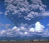
All Topics  
Mount Pinatubo

 
Mount Pinatubo

   Email Print
   Bookmark   Link


Mount Pinatubo


Mount Pinatubo is an active stratovolcano
Stratovolcano

A stratovolcano, sometimes called a composite volcano, is a tall, Volcanic cone volcano with many layers of hardened lava, tephra, and volcanic ash....
 located on the island of Luzon
Luzon

Luzon is the largest and most economically and politically important island in the Philippines and one of the three island groups in the country, with Visayas and Mindanao being the other two....
, at the intersection of the borders of the Philippine provinces of Zambales
Zambales

Zambales is a Provinces of the Philippines of the Philippines located in the Central Luzon Regions of the Philippines. Its capital is Iba, Zambales....
, Tarlac
Tarlac

Tarlac is a landlocked Provinces of the Philippines of the Philippines located in the Central Luzon Regions of the Philippines. Its capital is Tarlac City....
, and Pampanga
Pampanga

Pampanga is a Provinces of the Philippines of the Philippines located in the Central Luzon Regions of the Philippines. Its capital is the City of San Fernando, Pampanga....
. It is located in the Cabusilan Mountain range separating the west coast of Luzon from the central plains, and is 42 km (26 mi) west of the dormant and more prominent Mount Arayat
Mount Arayat

Mount Arayat is an inactive stratovolcano on Luzon Island, Philippines, rising to a height of 1,026 metres ASL. There is no recorded eruption of the volcano, and its last activity probably dates to the Holocene era....
, occasionally mistaken for Pinatubo. Ancestral Pinatubo was a stratovolcano made of andesite
Andesite

Andesite is an igneous rock, volcanic rock, of Igneous rock#Chemical classification, with aphanitic to porphyritic texture. The mineral assemblage is typically dominated by plagioclase plus pyroxene and/or hornblende....
 and dacite
Dacite

Dacite is an igneous rock, volcanic rock with a high iron content. It is intermediate in compositions between andesite and rhyolite, and, like andesite, it consists mostly of plagioclase feldspar with biotite, hornblende, and pyroxene ....
.


Discussion
Ask a question about 'Mount Pinatubo'
Start a new discussion about 'Mount Pinatubo'
Answer questions from other users
Full Discussion Forum


Recent Posts


Encyclopedia


Mount Pinatubo is an active stratovolcano
Stratovolcano

A stratovolcano, sometimes called a composite volcano, is a tall, Volcanic cone volcano with many layers of hardened lava, tephra, and volcanic ash....
 located on the island of Luzon
Luzon

Luzon is the largest and most economically and politically important island in the Philippines and one of the three island groups in the country, with Visayas and Mindanao being the other two....
, at the intersection of the borders of the Philippine provinces of Zambales
Zambales

Zambales is a Provinces of the Philippines of the Philippines located in the Central Luzon Regions of the Philippines. Its capital is Iba, Zambales....
, Tarlac
Tarlac

Tarlac is a landlocked Provinces of the Philippines of the Philippines located in the Central Luzon Regions of the Philippines. Its capital is Tarlac City....
, and Pampanga
Pampanga

Pampanga is a Provinces of the Philippines of the Philippines located in the Central Luzon Regions of the Philippines. Its capital is the City of San Fernando, Pampanga....
. It is located in the Cabusilan Mountain range separating the west coast of Luzon from the central plains, and is 42 km (26 mi) west of the dormant and more prominent Mount Arayat
Mount Arayat

Mount Arayat is an inactive stratovolcano on Luzon Island, Philippines, rising to a height of 1,026 metres ASL. There is no recorded eruption of the volcano, and its last activity probably dates to the Holocene era....
, occasionally mistaken for Pinatubo. Ancestral Pinatubo was a stratovolcano made of andesite
Andesite

Andesite is an igneous rock, volcanic rock, of Igneous rock#Chemical classification, with aphanitic to porphyritic texture. The mineral assemblage is typically dominated by plagioclase plus pyroxene and/or hornblende....
 and dacite
Dacite

Dacite is an igneous rock, volcanic rock with a high iron content. It is intermediate in compositions between andesite and rhyolite, and, like andesite, it consists mostly of plagioclase feldspar with biotite, hornblende, and pyroxene ....
. Before 1991, the mountain was inconspicuous and heavily eroded
Erosion

For morphological image processing operations, see Erosion 'For use of in dermatopathology, see Erosion Erosion is the removal of solids in the natural environment....
. It was covered in dense forest
Forest

File:Stara planina suma.jpgA forest is an area with a high density of trees. There are many definitions of a forest, based on various criteria....
 which supported a population of several thousand indigenous people, the Aeta
Aeta

The Aeta , Agta or Ayta are an indigenous people who live in scattered, isolated mountainous parts of Luzon, Philippines. They are considered to be Negritos, who are dark to very dark brown skinned and tend to have features such as a small stature, small frame, curly hair, small nose, and dark brown eyes....
, who had fled to the mountains from the lowlands during the protracted Spanish
Spanish Empire

The Spanish Empire was one of the largest empires in world history, and one of the first global empires. It included territories and colonies ruled by Spain in Europe, the Americas, Africa, Asia and Oceania between the 15th and late 19th centuries....
 conquest of the Philippines which first commenced in 1565.

The volcano's ultra-Plinian eruption in June 1991 produced the second largest terrestrial eruption of the 20th century (after the 1912 eruption of Novarupta
Novarupta

Novarupta, meaning "new eruption", is a volcano located on the Alaska Peninsula in Katmai National Park and Preserve, about southwest of Anchorage, Alaska....
) and the largest eruption in living memory. The colossal 1991 eruption had a Volcanic Explosivity Index
Volcanic Explosivity Index

The Volcanic Explosivity Index was devised by Christopher G. Newhall of the U.S. Geological Survey and Stephen Self at the University of Hawaii at Manoa in 1982 to provide a relative measure of the explosiveness of volcano eruptions....
 (VEI) of 6, and came some 450–500 years after the volcano's last known eruptive activity (estimated as VEI 5, the level of the 1980 eruption of Mount St. Helens
1980 eruption of Mount St. Helens

File:sthelens1.jpgThe 1980 eruption of Mount St. Helens, a stratovolcano located in Washington state, in the United States, was a major plinian eruption....
), and some 1000 years after previous VEI 6 eruptive activity. Successful predictions of the onset of the climactic eruption led to the evacuation of tens of thousands of people from the surrounding areas, saving many lives, but surrounding areas were severely damaged by pyroclastic flow
Pyroclastic flow

A pyroclastic flow is a common and devastating result of some volcano. The flows are fast-moving currents of hot gas and rock , which travel away from the volcano at speeds generally as great as 450 mi/h ....
s, ash deposits, and later by lahar
Lahar

A lahar is a type of mudflow or landslide composed of pyroclastic material and water that flows down from a volcano, typically along a river valley....
s caused by rainwater remobilizing earlier volcanic deposits: thousands of houses and other buildings were destroyed.

The effects of the eruption were felt worldwide. It ejected roughly 10 billion metric tonnes (10 cubic kilometres) of magma, and 20 million tons of SO2, bringing vast quantities of minerals and metals to the surface environment. It injected large amounts of aerosol
Particulate

Particulates, alternatively referred to as particulate matter or fine particles, are tiny particles of solid or liquid suspended in a gas or liquid....
s into the stratosphere
Stratosphere

The stratosphere is the second major layer of Earth's atmosphere, just above the troposphere, and below the mesosphere. It is stratified in temperature, with warmer layers higher up and cooler layers farther down....
—more than any eruption since that of Krakatoa
Krakatoa

Krakatoa , also spelled Krakatao, is a Island#Oceanic islands in the Sunda Strait between the islands of Java and Sumatra in Indonesia. The name is used for the island group, the main island , and the volcano as a whole....
 in 1883. Over the following months, the aerosols formed a global layer of sulfuric acid
Sulfuric acid

Sulfuric acid, hydrogen2sulfuroxygen4, is a strong mineral acid. It is soluble in water at all concentrations. Sulfuric acid has many applications, and is one of the top products of the chemical industry....
 haze. Global temperatures dropped by about 0.5 °C
Celsius

Celsius is a temperature scale that is named after the Swedish astronomer Anders Celsius , who developed a similar temperature scale two years before his death....
 (0.9 °F
Fahrenheit

Fahrenheit is a temperature scale named after the physicist Daniel Gabriel Fahrenheit , who proposed it in 1724. Today, the scale has largely been replaced by the Celsius scale; it is still in use for non-scientific purposes in the United States and a few other countries such as Belize....
), and ozone
Ozone

Ozone or trioxygen is a triatomic molecule, consisting of three oxygen atoms. It is an allotrope of oxygen that is much less stable than the diatomic O2....
 depletion temporarily increased substantially.

Overview of the Mount Pinatubo area


Tephra Fall From 1991 Eruption of Mt Pinatubo
Pinatubo is part of a chain of volcanoes which lie along the western edge of the island of Luzon
Luzon

Luzon is the largest and most economically and politically important island in the Philippines and one of the three island groups in the country, with Visayas and Mindanao being the other two....
. They are subduction
Subduction

In geology, subduction is the process that takes place at convergent boundary by which one tectonic plate moves under another tectonic plate, sinking into the Earth's mantle, as the plates converge....
 volcano
Volcano

A volcano is an opening, or rupture, in a planet's surface or Crust , which allows hot, molten rock, ash, and gases to escape from below the surface....
es, formed by the Philippine Plate
Philippine Plate

File:Philippine Sea plate.JPGThe Philippine Sea Plate is a tectonic plate beneath the Pacific Ocean to the east of the Philippines. The Philippine Sea Plate comprises oceanic lithosphere that lies beneath the Philippine Sea, and so has been referred to in the scientific literature of the last 50 years as the Philippine Sea Plate....
 sliding under the Eurasian Plate
Eurasian Plate

The Eurasian Plate is a tectonic plate which includes most of the continent of Eurasia , with the notable exceptions of the Indian subcontinent, the Arabian subcontinent, and the area east of the Chersky Range in East Siberia....
 along the Manila Trench
Manila Trench

The Manila Trench is an ocean trench in the South China Sea, west of the Philippines. It reaches a depth of about 5,000 m, in contrast with the average depth of the South China Sea of about 1,500 m....
 to the west. Mount Pinatubo lies on a destructive plate boundary.

The volcano is located 89 km (55 miles) northwest of Manila
Manila

The 'City of Manila' , or simply 'Manila', is the Capital of the Philippines and one of the 17 cities and municipalities that make up Metro Manila....
, 14 km (9 miles) west of the former Clark Air Base
Clark Air Base

Clark Air Base is a former United States Air Force base on Luzon Island in the Philippines, located 3 miles west of Angeles City, about 40 miles northwest of Metro Manila....
, and 37 km (23 mi) north of the former U.S. Naval Base Subic Bay
U.S. Naval Base Subic Bay

U.S. Naval Base Subic Bay was a major ship-repair, supply, and rest and recreation facility of the United States Navy located in Zambales, Philippines....
 . Clark Air Base's residential areas and petroleum storage facilities were in much closer proximity to the volcano than the airfield complex and neighboring Angeles City
Angeles City

Angeles City , geographically located within the province of Pampanga in the Philippines, is locally classified as a Cities of the Philippines#Classification city....
.

Several important river systems have their sources on Pinatubo, with the major rivers being the Bucao, Santo Tomas, Maloma, Tanguay and Kileng rivers. Before the eruption, these river systems were important ecosystem
Ecosystem

An ecosystem is a natural unit consisting of all plants, animals and micro-organisms in an area functioning together with all of the non-living physical factors of the environment....
s, but the eruption filled many valleys with deep pyroclastic deposits. Since 1991, the rivers have been clogged with sediment
Sediment

Sediment is any particulate matter that can be sediment transport by fluid dynamics, and which eventually is deposited.Sediments are most often transported by water transported by wind and glaciers....
, and the valleys have seen frequent lahar
Lahar

A lahar is a type of mudflow or landslide composed of pyroclastic material and water that flows down from a volcano, typically along a river valley....
s. Studies show that the river systems will take many years yet to recover from the 1991 eruption.

About 500,000 people continue to live within 40 km of the mountain, with population centres including the 150,000 in Angeles City
Angeles City

Angeles City , geographically located within the province of Pampanga in the Philippines, is locally classified as a Cities of the Philippines#Classification city....
, and 20,000 at Clark Freeport Zone
Clark Freeport Zone

Clark Freeport Zone is a redevelopment of the former Clark Air Base, a former United States Air Force base. It is located on the northwest side of Angeles City and borders the municipality of Mabalacat, Pampanga in the province of Pampanga....
.

Cultural history


The word 'pinatubo' means 'to have made grow' in Tagalog
Tagalog language

Tagalog is one of the major languages used in the Philippines. It is a basis for the Filipino language, which is the principal language of the national television and radio, though broadsheet newspapers are almost completely in English....
 and Sambal, which may suggest a knowledge of its previous eruption in about AD 1500, although there is no oral tradition among local people of earlier large eruptions. Pinatubo might instead mean a fertile place where crops can be made to grow. An indigenous group of people, the Aetas (also spelled as Ayta), had lived on the slopes of the volcano and in surrounding areas for several centuries, having fled the lowlands to escape persecution by the Spanish. They were a hunter-gatherer
Hunter-gatherer

A hunter-gatherer society is one whose primary List of subsistence techniques involves the direct procurement of edible plants and animals from the wild, foraging and hunting without significant recourse to the domestication of either....
 people who were extremely successful in surviving in the dense jungles of the area. These people also grew some staple crops such as wheat, barley and rice.

Before the catastrophic eruption of 1991, Pinatubo was an inconspicuous volcano, unknown to most people in the surrounding areas. Its summit was 1,745 m (5,725 ft) above sea level, but only about 600 m above nearby plain
Plain

In geography, a plain is an area of landscape with relatively high relief, as well as flat. Prairies and steppes are types of plains, and the archetype for a plain is often thought of as a grassland, but plains in their natural state may also be covered in shrublands, woodland and forest, or vegetation may be absent in the case of sandy or...
s, and about 200 m higher than surrounding peaks, which largely obscured it from view. Philippine President
President of the Philippines

File:Flag President of Philippines.pngThe President of the Philippines is the head of state and government of the Philippines. The President of the Philippines in Filipino is referred to as Ang Pangulo or Pangulo ....
 Ramon Magsaysay
Ramon Magsaysay

Ramon del Fierro Magsaysay was the third President of the Third Republic of the Philippines from December 30, 1953 until his death in a 1957 Cebu Douglas C-47 crash....
, a native of Zambales, named his C-47
C-47 Skytrain

The Douglas C-47 Skytrain or Dakota is a military transport that was developed from the Douglas DC-3 airliner. It was used extensively by the Allies during World War II and remained in front line operations through the 1950s with a few remaining in operation to this day....
 presidential plane "Mt. Pinatubo". The plane crashed in 1957
1957 Cebu Douglas C-47 crash

The 1957 crash of a Douglas C-47 plane named "Mt. Pinatubo" on the slopes of Mount Manunggal, Cebu, Philippines, killed the 7th President of the Philippines, Ramon Magsaysay, and 24 other passengers....
, killing the President and 24 others onboard.

In total, about 30,000 people lived on the flanks of the volcano in barangay
Barangay

A barangay , also known by its former Spanish adopted name, the barrio, is the smallest administrative division in the Philippines and is the native Filipino term for a village, district or Ward ....
s (villages) and other small settlements. The dense jungle covering most of the mountain and surrounding peaks supported the hunter-gathering Aeta, while on the surrounding flatter areas, the abundant rainfall (almost 4 m annually) provided by the monsoon
Monsoon

A monsoon is a seasonal prevailing wind that lasts for several months. The term was first used in English in India, Bangladesh, Pakistan, and neighboring countries to refer to the big seasonal winds blowing from the Indian Ocean and Arabian Sea in the southwest bringing heavy rainfall to the region....
 climate and the fertile volcanic soils provided excellent conditions for agriculture
Agriculture

Agriculture refers to the production of food and goods through farming and forestry. Agriculture was the key development that led to the rise of civilization, with the animal husbandry of domestication animals and plants creating food surpluses that enabled the development of more Population density and Social stratification societies....
, and many people grew rice
Rice

Rice is a staple food for a large part of the world's human population, especially in tropical Latin America, and East Asia, South Asia and Southeast Asia, making it the second-most consumed cereal grain, after maize....
 and other staple foods.

Geological history


Although there seems to be no local knowledge of the previous large eruptions in the Pinatubo area, several Aeta residents reported in 1991 that their elders recalled small explosions in the past. Pinatubo was a known geothermal
Geothermal (geology)

In geology, geothermal refers to heat sources within the planet. Geothermal is technically an adjective but in U.S. English the word has attained frequent use as a noun ....
 area before the 1991 eruption, and small steam explosions are quite common in such areas. It was only after volcanic activity began in 1991 that geologists studied the eruptive history of the region in any detail. Eruptions at the site can be divided into two major eras.

Ancestral Pinatubo


Pre Eruption Pinatubo
Much of the rugged land surrounding the present volcano consists of remnants of 'ancestral' Pinatubo. This volcano was located roughly in the same place as the present mountain, and activity seems to have begun about 1.1 million years ago. Ancestral Pinatubo may have reached a height of up to 2,300 m
M

M is the thirteenth letter of the modern Latin alphabet. Its name in English language is spelled em ....
 (7,550 ft) above sea level
Sea level

Mean sea level is the average height of the sea, with reference to a suitable reference surface. Defining the reference level , however, involves complex measurement, and accurately determining MSL can prove difficult....
, based on profile fitting to the remaining lower slopes.

Several mountains near modern Pinatubo are old satellite vents of ancestral Pinatubo, formed from volcanic plug
Volcanic plug

A volcanic plug, also called a volcanic neck or lava neck, is a volcano landform created when magma hardens within a vent on an active volcano....
s and lava dome
Lava dome

In volcanology, a lava dome or plug dome is a roughly circular mound-shaped protrusion resulting from the slow eruption of felsic lava from a volcano, or from multiple lava episodes of different magma types....
s. Some nearby peaks are also remnants of ancestral Pinatubo, formed from erosion
Erosion

For morphological image processing operations, see Erosion 'For use of in dermatopathology, see Erosion Erosion is the removal of solids in the natural environment....
-resistant parts of the old mountain slopes left behind when the less resistant parts were eroded away by weathering
Weathering

Weathering is the decomposition of earth Rock , soils and their minerals through direct contact with the planet's atmosphere. Weathering occurs in situ, or "with no movement", and thus should not be confused with erosion, which involves the movement of rocks and minerals by agents such as water, ice, wind, and gravity....
.

The eruptive activity of ancestral Pinatubo was much less explosive than modern Pinatubo, and probably ended about 45,000 years ago. After a long period of dormancy, modern Pinatubo was born in eruptions beginning about 35,000 years ago.

Modern Pinatubo


The birth of modern Pinatubo occurred in the most explosive eruption in its history, which deposited pyroclastic flow
Pyroclastic flow

A pyroclastic flow is a common and devastating result of some volcano. The flows are fast-moving currents of hot gas and rock , which travel away from the volcano at speeds generally as great as 450 mi/h ....
 material up to 100 meters thick on all sides of the mountain. The total volume of material erupted may have been up to 25 cubic kilometers (6 mileł), and the removal of this amount of material from the underlying magma chamber
Magma chamber

A magma chamber is a large underground pool of molten Rock lying under the surface of the earth's crust. The molten rock in such a chamber is under great pressure, and given enough time pressure can gradually fracture the rock around it creating outlets for the magma....
 led to the formation of a large caldera
Caldera

A caldera is a cauldron-like volcano feature usually formed by the collapse of land following a volcanic eruption such as the one at Yellowstone National Park....
.

Earlier large eruptions occurred 17,000, 9000, 6000–5000 and 3900–2300 years ago. Each of these eruptions seems to have been very large, ejecting more than 10 kmł of material and covering large parts of the surrounding areas with pyroclastic flow deposits. Scientists estimate that the most recent eruption before 1991 happened about 450 years ago, and after that, the volcano lay dormant. Its slopes became completely covered in dense rainforest
Rainforest

Rainforests are forests characterized by high rainfall, with definitions setting minimum normal annual rainfall between 1750?2000 mm . The monsoon trough, alternately known as the intertropical convergence zone, plays a significant role in creating Earth's tropical rain forests....
, and eroded into gullies and ravines.

1991 awakening


Pinatubo Early Eruption 1991
On July 16, 1990, an earthquake
1990 Luzon earthquake

The 1990 Luzon earthquake occurred on Monday, July 16, 1990, at 4:26 PM local time in the Philippines. The densely populated island of Luzon was struck by an earthquake with a 7.8 Richter magnitude scale....
 of magnitude 7.7 struck central Luzon. This was the largest earthquake recorded in 1990, comparable in size to the 1906 San Francisco earthquake
1906 San Francisco earthquake

The San Francisco earthquake of 1906 was a major earthquake that struck San Francisco, California, California and the coast of Northern California at 5:12 A.M....
 and the 2008 Sichuan earthquake
2008 Sichuan earthquake

The List_of_deadliest_natural_disasters#Earthquakes, the 2008 Sichuan earthquake , or "Great Sichuan Earthquake", which measured at 8.0 Surface wave magnitude
. Its epicenter was at Cabanatuan City
Cabanatuan City

The City of Cabanatuan is a first class, partially urban Philippine city in the Philippine province of Nueva Ecija province, Philippines. It is considered the economic hub of the province....
, about 100 km northeast of Pinatubo, leading some volcanologists to speculate that it might ultimately have triggered the 1991 eruption, although this is impossible to prove conclusively. Two weeks after the earthquake, local residents reported steam
Steam

In physical chemistry, and in engineering, steam refers to vaporized water. It is a pure, completely invisible gaseous phase . At standard temperature and pressure, pure steam occupies about 1,600 times the volume of an equal mass of liquid water....
 coming from the volcano, but scientists visiting the mountain found that small landslide
Landslide

File:Guatemala landslide.jpgA landslide is a List of geological phenomena which includes a wide range of ground movement, such as rock falls, deep failure of slopes and shallow debris flows, which can occur in offshore, coastal and onshore environments....
s rather than any eruptive activity were responsible.

On March 15, 1991, a succession of earthquakes was felt by villagers on the north-western side of the volcano. Further earthquakes of increasing intensity were felt over the next two weeks, and it became clear some kind of volcanic activity was imminent. On April 2, the volcano awoke, with phreatic eruption
Phreatic eruption

A Phreatic eruption, also called an ultravulcanian eruption, occurs when rising magma makes contact with ground water or surface water. The extreme temperature of the magma causes near-instantaneous evaporation to steam resulting in an explosion of steam, water, ash, rock, and volcanic bombs....
s occurring near the summit along a 1.5 km long fissure
Fissure

In anatomy, fissure is a groove, natural division, deep furrow, cleft, or tear in various parts of the body....
. Over the next few weeks, small eruptions continued, dusting the surrounding areas with ash
Volcanic ash

Volcanic ash consists of small tephra, which are bits of pulverized rock and glass created by volcano eruptions, less than in diameter. There are three mechanisms of volcanic ash formation: gas release under decompression causing magmatic eruptions; thermal contraction from chilling on contact with water causing phreatomagmatic eruptions...
. Seismographs recorded hundreds of small earthquakes every day.

Scientists immediately installed monitoring equipment and analyzed the volcano for clues as to its previous eruptive history. Radiocarbon dating
Radiocarbon dating

Radiocarbon dating, or carbon dating, is a radiometric dating method that uses the naturally occurring radioisotope carbon-14 to determine the age of carbonaceous materials up to about 60,000 years....
 of charcoal found in old volcanic deposits revealed the three major explosive eruptions in recent millennia, about 5500, 3500 and 500 years ago. Geological mapping showed that much of the surrounding plains were formed by lahar
Lahar

A lahar is a type of mudflow or landslide composed of pyroclastic material and water that flows down from a volcano, typically along a river valley....
 deposits from previous eruptions.

Volcanic activity increased throughout. Measurements of sulfur dioxide
Sulfur dioxide

Sulfur dioxide is the chemical compound with the formula SO2. It is produced by volcanoes and in various industrial processes. Since coal and petroleum often contain sulfur compounds, their combustion generates sulfur dioxide....
 emission showed a rapid increase from 500 ton
Ton

Units of massThere are several similar units of mass or volume called the ton:Others*The long ton is used for petroleum products such as aviation fuel....
s per day by May 13 to 5,000 tons/day by May 28. This implied that there was a rising column of fresh magma
Magma

Magma is molten Rock that is found beneath the surface of the Earth, and may also exist on other terrestrial planets. Besides molten rock, magma may also contain suspended crystals and gas bubbles....
 beneath the volcano. After May 28, the amount of SO2 being emitted decreased substantially, raising fears that the degassing of the magma had been blocked somehow, leading to a pressure
Pressure

Pressure is the force per unit area applied to an object in a direction surface normal to the surface. Gauge pressure is the pressure relative to the local atmospheric or ambient pressure....
 build-up in the magma chamber
Magma chamber

A magma chamber is a large underground pool of molten Rock lying under the surface of the earth's crust. The molten rock in such a chamber is under great pressure, and given enough time pressure can gradually fracture the rock around it creating outlets for the magma....
 and a high likelihood of explosive eruptions.

The first magma
Magma

Magma is molten Rock that is found beneath the surface of the Earth, and may also exist on other terrestrial planets. Besides molten rock, magma may also contain suspended crystals and gas bubbles....
tic eruptions occurred on June 3, and the first large explosion on June 7 generated an ash column 7 km (4.5 miles) high. The Philippine Institute of Volcanology
Volcanology

Volcanology is the study of volcanoes, lava, magma, and related geology and geophysical phenomena. The term volcanology is derived from the Latin language word Vulcan , the Roman mythology of fire....
 and Seismology
Seismology

Seismology is the scientific study of earthquakes and the propagation of Linear elasticity#Elastic waves through the Earth. The field also includes studies of earthquake effects, such as tsunamis as well as diverse seismic sources such as volcanic, tectonic, oceanic, atmospheric, and artificial processes ....
 (PHIVOLCS) led by Raymundo Punongbayan
Raymundo Punongbayan

Dr. Raymundo Santiago Punongbayan was the former director of the Philippine Institute of Volcanology and Seismology . He served from 1983 to 2002....
 issued a warning indicating the possibility of a major eruption within two weeks.

Evacuation


Pinatubo Evacuation Areas
Given all the signs that a very large eruption was imminent, the Philippines Institute of Volcanology and Seismology (PHIVOLCS) assisted by the US Geological Survey, worked to convince people in the local area of the severity of the threat. A false warning might have led to cynicism about any later warnings but delaying a warning until an eruption began might lead to thousands of deaths, so the volcanologists were under some pressure to deliver a timely and accurate assessment of the volcanic risk.

Three successive evacuation zones were defined, the innermost containing everything within 10 km of the volcano's summit, the second extending from 10 to 20 km from the summit, and the third extending from 20 to 40 km from the summit (Clark Air Base
Clark Air Base

Clark Air Base is a former United States Air Force base on Luzon Island in the Philippines, located 3 miles west of Angeles City, about 40 miles northwest of Metro Manila....
 and Angeles City
Angeles City

Angeles City , geographically located within the province of Pampanga in the Philippines, is locally classified as a Cities of the Philippines#Classification city....
 were in this zone). The 10 km and 10–20 km zones had a total population of about 40,000, while some 331,000 people lived in the 20–40 km zone. Five stages of volcanic alert were defined, from level 1 (low level seismic disturbances) up to level 5 (major eruption in progress). Daily alerts were issued stating the alert level and associated danger area, and the information was announced in major national and local newspaper
Newspaper

A newspaper is a publication containing news, information and advertising, usually printed on low-cost paper called newsprint. General-interest newspapers often feature articles on Politics, crime, business, art/entertainment, society and sports....
s, radio
Radio

Radio is the transmission of signals, by modulation of electromagnetic radiation with frequency below those of visible light.Electromagnetic radiation radio propagation by means of oscillating electromagnetic fields that pass through the air and the vacuum of space....
 and television
Television

Television is a widely used telecommunication mass-media for transmitting and receiving moving , either monochrome or color, usually accompanied by sound....
 stations, nongovernmental organizations (NGOs), and directly to the endangered inhabitants.

Many of the Aeta who lived on the slopes of the volcano left their villages of their own volition when the first explosions began in April, gathering in a village about 12 km from the summit. They moved to increasingly distant villages as the eruptions escalated, with some Aeta moving up to nine times in the two months preceding the cataclysmic eruption.

The first formal evacuations were ordered from the 10 km zone on April 7. Evacuation of the 10–20 km zone was ordered when a level 4 alert was issued on June 7. A level 5 alert triggered evacuation of the 20–40 km zone on June 14, and in all some 60,000 people had left the area within 30 km of the volcano before June 15. Most people temporarily relocated to Manila
Manila

The 'City of Manila' , or simply 'Manila', is the Capital of the Philippines and one of the 17 cities and municipalities that make up Metro Manila....
 and Quezon City
Quezon City

Quezon City , is the former capital and the most populous city in the Philippines. Located on the island of Luzon, Quezon City is one of the Cities of the Philippines and Philippine municipality that make up Metro Manila, the National Capital Region....
, with some 30,000 using the Amoranto Velodrome
Amoranto Velodrome

The Amoranto Velodrome is located inside the Amoranto Sports Complex in Quezon City, Philippines. In 2005, it was the venue for the cycling track events of the Cycling at the 2005 Southeast Asian Games....
 in Quezon City as an evacuee camp.

Eruptions build to a climax


Vertical Eruption At Pinatubo, 1991
In early June, tiltmeter
Tiltmeter

A tiltmeter is an instrument designed to measure very small changes from the horizontal level, either on the ground or in structures. A similar term, in less common usage, is the inclinometer....
 measurements had shown that the volcano was inflating, evidently due to growing amounts of magma filling the reservoir beneath the summit. At the same time, seismic activity, previously concentrated at a depth of a few kilometers below a point about 5 km northwest of the summit, shifted to shallow depths just below the summit. On June 7, the first magmatic eruptions took place with the formation of a lava dome
Lava dome

In volcanology, a lava dome or plug dome is a roughly circular mound-shaped protrusion resulting from the slow eruption of felsic lava from a volcano, or from multiple lava episodes of different magma types....
 at the summit of the volcano. The dome grew substantially over the next five days, reaching a maximum diameter of about 200 m and a height of 40 m.

A small explosion at 03:41 on June 12 marked the beginning of a new, more violent phase of the eruption. A few hours later, large explosions lasting about half an hour generated an eruption column
Eruption column

An eruption column consists of hot volcanic ash emitted during an explosive volcanic eruption. The ash forms a column rising many kilometres into the air above the peak of the volcano....
 which quickly reached heights of over 19 km, and which generated pyroclastic flow
Pyroclastic flow

A pyroclastic flow is a common and devastating result of some volcano. The flows are fast-moving currents of hot gas and rock , which travel away from the volcano at speeds generally as great as 450 mi/h ....
s extending up to 4 km from the summit in some river valley
Valley

In geology, a valley is a Depression with predominant extent in one direction. A very deep river valley may be called a canyon or gorge....
s. Fourteen hours later, a 15 minute eruption hurled ash to heights of 24 km. Friction in the uprushing ash column generated abundant lightning
Lightning

File:Blesk.jpgLightning is an Earth's atmosphere discharge of electricity usually accompanied by thunder, which typically occurs during thunderstorms, and sometimes during volcano or dust storms....
.

A third large eruption began at 08:41 on June 13, after an intense swarm of small earthquakes over the previous two hours. It lasted about five minutes, and the eruption column once again reached 24 km. After three hours of quiet, seismic activity began, growing more and more intense over the next 24 hours, until a three-minute eruption generated a 21 km-high eruption column at 13:09 on June 14.

Tephra
Tephra

Tephra is air-fall material produced by a Volcano regardless of composition or fragment size. Tephra is typically Rhyolite in composition, as most explosive volcanoes are the product of the more viscosity felsic or high silica magmas....
 fall from these four large eruptions was extensive to the southwest of the volcano. Two hours after the last of these four explosions, a series of eruptions began which lasted for the next 24 hours, and which saw the production of much larger pyroclastic flows and surges which travelled several kilometres down river valleys on the flanks of the volcano.

Dacite
Dacite

Dacite is an igneous rock, volcanic rock with a high iron content. It is intermediate in compositions between andesite and rhyolite, and, like andesite, it consists mostly of plagioclase feldspar with biotite, hornblende, and pyroxene ....
 was the igneous rock
Igneous rock

Igneous rock is one of the three main Rock types . Igneous rock is formed by magma being cooled and becoming solid . They may form with or without crystallization, either below the surface as Intrusion rocks or on the surface as extrusive rocks....
 making up the tephra in these eruptions and in the following climactic event. The most abundant phenocryst
Phenocryst

A phenocryst is a relatively large and usually conspicuous crystal distinctly larger than the grains of the rock Matrix of a porphyritic igneous rock....
 minerals were hornblende
Hornblende

Hornblende is a complex silicate minerals series of minerals. Hornblende is not a recognized mineral in its own right, but the name is used as a general or field term, to refer to a dark amphibole....
 and plagioclase
Plagioclase

Plagioclase is a very important series of Silicate minerals minerals within the feldspar family. Rather than referring to a particular mineral with a specific chemical composition, plagioclase is a solid solution series, more properly known as the plagioclase feldspar series ....
, but an unusual phenocryst mineral was also present—the calcium sulfate, anhydrite
Anhydrite

Anhydrite is a mineral - anhydrous calcium sulfate, CaSO4. It is in the orthorhombic crystal system, with three directions of perfect cleavage parallel to the three planes of symmetry....
. The dacite magma
Magma

Magma is molten Rock that is found beneath the surface of the Earth, and may also exist on other terrestrial planets. Besides molten rock, magma may also contain suspended crystals and gas bubbles....
 was more oxidized than most magmas, and sulfur-rich nature of the eruption probably was causally related to the redox state
Mineral redox buffer

In geology, a redox buffer is an assemblage of minerals or compounds that constrains oxygen fugacity as a function of temperature. Knowledge of the redox conditions at which a rock forms and evolves can be important for interpreting the rock history....
.

The climactic eruption


Vulcanopinatubojune1991


June 15 saw the onset of the climactic eruption. Large tremors starting at 13:42 saturated all the seismographs at Clark Air Base
Clark Air Base

Clark Air Base is a former United States Air Force base on Luzon Island in the Philippines, located 3 miles west of Angeles City, about 40 miles northwest of Metro Manila....
, and by 14:30 all had been rendered inoperative, mostly by pyroclastic density currents. Intense atmospheric
Earth's atmosphere

The Earth's atmosphere is a layer of gases surrounding the planet Earth that is retained by the Earth's gravity. Dry air contains roughly 78.08% nitrogen, 20.95% oxygen, 0.93% argon, 0.038% Carbon dioxide in the Earth's atmosphere, and trace amounts of other gases....
 pressure variation was also recorded.

On the same day, Typhoon Yunya
1991 Pacific typhoon season

The 1991 Pacific typhoon season has no official bounds; it ran year-round in 1991, but most tropical cyclones tend to form in the northwestern Pacific Ocean between May and November....
 struck the island, passing about 75 km (50 miles) north
North

North is one of the four cardinal directions, specifically the direction that, in Western culture, is treated as the fundamental direction:...
 of the volcano. The typhoon rains made direct visual observations of the eruption impossible, but measurements showed that ash was ejected to heights of 34 km by the most violent phase of the eruption, which lasted about three hours. Pyroclastic flow
Pyroclastic flow

A pyroclastic flow is a common and devastating result of some volcano. The flows are fast-moving currents of hot gas and rock , which travel away from the volcano at speeds generally as great as 450 mi/h ....
s poured from the summit, reaching as far as 16 km away from it. Typhoon rains mixed with the ash deposits caused massive lahars.

The ash cloud from the volcano covered an area of some 125,000 km˛ (50,000 mi˛), bringing total darkness to much of central Luzon. Almost all of the island received some ashfall, which formed a heavy, rain-saturated snow-like blanket. Tephra
Tephra

Tephra is air-fall material produced by a Volcano regardless of composition or fragment size. Tephra is typically Rhyolite in composition, as most explosive volcanoes are the product of the more viscosity felsic or high silica magmas....
 fell over most of the South China Sea
South China Sea

The South China Sea is a marginal sea*south of China,*west of the Philippines,*north west of Sabah , Sarawak and Brunei,*north of Indonesia,...
 and ashfall was recorded as far away as Vietnam
Vietnam

Vietnam , officially the Socialist Republic of Vietnam , is the easternmost country on the Indochina Peninsula in Southeast Asia. It is bordered by People's Republic of China to the north, Laos to the northwest, Cambodia to the southwest, and the South China Sea to the east....
, Cambodia
Cambodia

The Kingdom of Cambodia is a country in South East Asia with a population of over 13 million people. The kingdom's capital and largest city is Phnom Penh....
 and Malaysia
Malaysia

Malaysia is a federation that consists of States of Malaysia in Southeast Asia with a total landmass of . The capital city is Kuala Lumpur, while Putrajaya is the seat of the federal government....
.

By about 22:30, nine hours after the onset of the climactic phase, atmospheric pressure waves had decreased to the pre-eruption levels. No seismic records were available at this time, but volcanologists believe 22:30 marked the end of the climactic eruption.

Vast quantities of minerals and metals were brought to the surface. Overall, introduced to the surface environment, was an estimated 800,000 tons of zinc
Zinc

Zinc is a metallic chemical element with the symbol Zn and atomic number 30. It is a first-row transition metal of the group 12 element of the periodic table....
, 600,000 tons of copper
Copper

Copper is a chemical element with the symbol Cu and atomic number 29.It is a ductile metal with very high thermal and electrical conductivity....
, 550,000 tons of chromium
Chromium

Chromium is a chemical element which has the symbol Cr and atomic number 24. It is a steely-gray, Lustre , hard metal that takes a high polish and has a high melting point....
, 300,000 tons of nickel
Nickel

Nickel is a chemical element, with the chemical symbol Ni and atomic number 28. It is a silvery-white lustrous metal with a slight golden tinge....
, 100,000 tons of lead
Lead

Lead is a main-group Chemical element with symbol Pb and atomic number 82. Lead is a soft, malleable poor metal, also considered to be one of the heavy metal ....
, 10,000 tons of arsenic
Arsenic

Arsenic is a well-known chemical element that has the symbol As and atomic number 33. Arsenic was first documented by Albertus Magnus in 1250....
, 1000 tons of cadmium
Cadmium

Cadmium is a chemical element with the symbol Cd and atomic number 48. A relatively abundant , soft, bluish-white, transition metal, cadmium is known to cause cancer and occurs with zinc ores....
, & 800 tons of mercury
Mercury (element)

Mercury , also called quicksilver or hydrargyrum , is a chemical element with the symbol Hg and atomic number 80. A heavy, silvery d-block metal, mercury is one of six elements that are liquid at or near room temperature and pressure....
.

Aftermath

Ashfall From Pinatubo, 1991
In all, the eruption ejected about ten cubic kilometres (2.5 mileł) of material, making it the largest eruption since that of Novarupta
Novarupta

Novarupta, meaning "new eruption", is a volcano located on the Alaska Peninsula in Katmai National Park and Preserve, about southwest of Anchorage, Alaska....
 in 1912 and some ten times larger than the 1980 eruption of Mount St. Helens
1980 eruption of Mount St. Helens

File:sthelens1.jpgThe 1980 eruption of Mount St. Helens, a stratovolcano located in Washington state, in the United States, was a major plinian eruption....
. Ejected material such as tephra
Tephra

Tephra is air-fall material produced by a Volcano regardless of composition or fragment size. Tephra is typically Rhyolite in composition, as most explosive volcanoes are the product of the more viscosity felsic or high silica magmas....
 fallout and pyroclastic flow deposits are much less dense than magma, and the volume of ejected material was equivalent to about four cubic kilometres (1 mileł) of unerupted material. This colossal eruption had a Volcanic Explosivity Index
Volcanic Explosivity Index

The Volcanic Explosivity Index was devised by Christopher G. Newhall of the U.S. Geological Survey and Stephen Self at the University of Hawaii at Manoa in 1982 to provide a relative measure of the explosiveness of volcano eruptions....
 of 6. The former summit of the volcano was replaced by a caldera
Caldera

A caldera is a cauldron-like volcano feature usually formed by the collapse of land following a volcanic eruption such as the one at Yellowstone National Park....
 2.5 km wide. The highest point on the caldera rim now stood 1,485 m above sea level, some 260 m lower than the pre-eruption summit.

About 300 people were killed by the eruption, mostly by roofs collapsing under the weight of accumulated wet ash, a hazard that was greatly exacerbated by the simultaneous arrival of Typhoon Yunya. The evacuation in the days preceding the eruption certainly saved tens of thousands of lives, and has been hailed as a great success for volcanology and eruption prediction.

River Valley Filled in By Pyroclastic Flows, Mt
However, since the eruption, each rainy season has brought further lahars, which have caused the displacement of thousands of people. Hundreds have died from poor sanitation
Sanitation

Sanitation is the hygienic means of preventing human contact from the hazards of wastes to promote health. Hazards can be either physical, microbiological, biological or chemical agents of disease....
 in relocation camps. Agriculture
Agriculture

Agriculture refers to the production of food and goods through farming and forestry. Agriculture was the key development that led to the rise of civilization, with the animal husbandry of domestication animals and plants creating food surpluses that enabled the development of more Population density and Social stratification societies....
 in the region also suffered badly from the effects of the eruption, with hundreds of square kilometres of formerly arable land
Arable land

In geography, arable land is an agriculture term, meaning land that can be used for growing agriculture. Arable land is currently being lost at the rate of over 200,000 km? per year....
 being rendered infertile, destroying the livelihoods of thousands of farmers.

The United States maintained two large military bases in the region; U.S. Naval Base Subic Bay
U.S. Naval Base Subic Bay

U.S. Naval Base Subic Bay was a major ship-repair, supply, and rest and recreation facility of the United States Navy located in Zambales, Philippines....
 was 75 km (50 mi.) to the southwest, while Clark Air Base
Clark Air Base

Clark Air Base is a former United States Air Force base on Luzon Island in the Philippines, located 3 miles west of Angeles City, about 40 miles northwest of Metro Manila....
 was less than 25 km (16 mi.) to the east of the volcano's summit. The United States Air Force
United States Air Force

The United States Air Force is the aerial warfare branch of the Military of the United States and one of the uniformed services of the United States....
 initiated a massive airlift
Airlift

Airlift may refer to:*Airlift, in logistics, the act of transporting people or cargo from point to point using aircraft*Airlift , in nautical archaeology, a suction device for moving sand and silt underwater...
 effort to evacuate American servicemembers and their families during and immediately following the eruption. Most personnel were initially relocated to Guam
Guam

Guam , officially the Territory of Guam, is an island in the western Pacific Ocean and is an organized, unincorporated insular area of the United States....
, Okinawa, and Hawaii
Hawaii

File:Pahoehoe and Aa flows at Hawaii.jpgThe State of Hawaii is a U.S. state in the United States, located on an archipelago in the central Pacific Ocean southwest of the continental United States, southeast of Japan, and northeast of Australia....
, although some returned to the continental United States
United States

The United States of America is a Federal government constitutional republic comprising U.S. state and a federal district. The country is situated mostly in central North America, where its Contiguous United States and Washington, D.C., the Capital districts and territories, lie between the Pacific Ocean and Atlantic Oceans, Borders of the U...
. Clark Air Base was ultimately abandoned by the United States military, and Subic Bay reverted to Philippines control the next year following the breakdown of lease negotiations.

Although the 1991 eruption was one of the largest and most violent of the 20th century, it was weaker than any of the historical eruptions uncovered by geologists. There is some evidence that eruptions at Pinatubo are getting weaker over time, but this is by no means conclusively established.

Local economic and social effects


Collapsed Hangars At Clark Air Base
The eruption of Pinatubo severely hampered the economic development
Economic development

Economic development is the development of wealth of countries or regions for the well-being of their inhabitants. It is the process by which a nation improves the economic, political, and social well being of its people....
 of the surrounding areas. Extensive damage to buildings and infrastructure
Infrastructure

Infrastructure can be defined as the basic physical and organizational structures needed for the operation of a society or enterprise , or the services and facilities necessary for an economy to function....
 cost billions of peso
Philippine peso

The peso is the currency of the Philippines. It is subdivided into 100 centavos or sentimo . Before 1967, the language used on the banknotes and coins was English language and so "peso" was the name used....
s to repair, and further costs were incurred in constructing dikes and dam
Dam

A dam is a barrier that Reservoirs surface water or underground streams. Dams generally serve the primary purpose of retaining water, while other structures such as floodgates, levees, and Dike are used to manage or prevent water flow into specific land regions....
s to control the post-eruption lahars.

In total, 364 communities and 2.1 million people were affected by the eruption, with livelihoods and houses being damaged or destroyed. More than 8,000 houses were completely destroyed, and a further 73,000 were damaged. In addition to the severe damage sustained by these communities, roads and communications were damaged or destroyed by pyroclastic flows and lahars throughout the areas surrounding the volcanoes. The estimated cost of repairing the damage to infrastructure was 3.8 billion pesos.

Many reforestation
Reforestation

Reforestation is the restocking of existing forests and woodlands which have been depleted, with native tree stock. The term reforestation can also refer to afforestation, the process of restoring and recreating areas of woodlands or forest that once existed but were deforestation or otherwise removed or destroyed at some point in the pas...
 projects were destroyed in the eruption, with a total area of 150 square kilometres (37,000 acre
Acre

The acre is a Units of measurement of area in a number of different systems, including the Imperial unit#Measures of area and United States customary units#Units of area systems....
s) valued at 125 million pesos destroyed. Agriculture
Agriculture

Agriculture refers to the production of food and goods through farming and forestry. Agriculture was the key development that led to the rise of civilization, with the animal husbandry of domestication animals and plants creating food surpluses that enabled the development of more Population density and Social stratification societies....
 was heavily disrupted, with 800 square kilometres (200,000 acres) of rice
Rice

Rice is a staple food for a large part of the world's human population, especially in tropical Latin America, and East Asia, South Asia and Southeast Asia, making it the second-most consumed cereal grain, after maize....
-growing farmland destroyed, and almost 800,000 head of livestock and poultry
Poultry

Poultry is the category of domesticated birds which some people keep for the purpose of collecting their egg , or kill for their meat and/or feathers....
 killed. The cost to agriculture of eruption effects was estimated to be 1.5 billion pesos.

Damage to healthcare facilities, and the spread of illnesses in relocation facilities, led to soaring death rates in the months following the eruption. Education
Education

File:Inukshuk Monterrey 1.jpgEducation can be seen as a product or a process and considered in a broad sense or a technical sense. According to philosophy of education George F....
 for thousands of children was seriously disrupted by the destruction of school
School

File:Primary Student of Pakistan.JPGA school , is an institution designed to allow and encourage students to education, under the supervision of teachers....
s in the eruption. The gross regional domestic product of the Pinatubo area accounted for about 10% of the total Philippine gross domestic product
Gross domestic product

File:GDP nominal per capita world map IMF 2008.pngThe gross domestic product or gross domestic income is one of the measures of national income and output for a given country's economy....
. The GRDP had been growing at 5% annually before the eruption, but fell by more than 3% from 1990 to 1991.

Global environmental effects


Pinatubo Dust Layer
The powerful eruption of such an enormous volume of lava and ash injected significant quantities of aerosols
Particulate

Particulates, alternatively referred to as particulate matter or fine particles, are tiny particles of solid or liquid suspended in a gas or liquid....
 and dust
Dust

Dust is a general name for minute solid particles with diameters less than 20 Thou . Particles in the Earth's atmosphere arise from various sources such as soil dust lifted up by wind, volcanic eruptions, and pollution....
 into the stratosphere
Stratosphere

The stratosphere is the second major layer of Earth's atmosphere, just above the troposphere, and below the mesosphere. It is stratified in temperature, with warmer layers higher up and cooler layers farther down....
. Sulfur dioxide
Sulfur dioxide

Sulfur dioxide is the chemical compound with the formula SO2. It is produced by volcanoes and in various industrial processes. Since coal and petroleum often contain sulfur compounds, their combustion generates sulfur dioxide....
 oxidised in the atmosphere to produce a haze of sulfuric acid
Sulfuric acid

Sulfuric acid, hydrogen2sulfuroxygen4, is a strong mineral acid. It is soluble in water at all concentrations. Sulfuric acid has many applications, and is one of the top products of the chemical industry....
 droplets, which gradually spread throughout the stratosphere over the year following the eruption. The injection of aerosols into the stratosphere is thought to have been the largest since the eruption of Krakatoa
Krakatoa

Krakatoa , also spelled Krakatao, is a Island#Oceanic islands in the Sunda Strait between the islands of Java and Sumatra in Indonesia. The name is used for the island group, the main island , and the volcano as a whole....
 in 1883, with a total mass of SO2 of about 17 million tons being injected—the largest volume ever recorded by modern instruments (see chart and figure).

This very large stratospheric injection resulted in a reduction in the normal amount of sunlight
Sunlight

Sunlight, in the broad sense, is the total spectroscopy of the electromagnetic radiation given off by the Sun. On Earth, sunlight is Filter ed through the Earth's atmosphere, and the solar radiation is obvious as daylight when the Sun is above the horizon....
 reaching the Earth's surface by roughly 10% (see figure). This led to a decrease in northern hemisphere
Northern Hemisphere

The Northern Hemisphere is the half of a planet that is north of the equator?the word sphere literally means 'half sphere'. It is also that half of the celestial sphere north of the celestial equator....
 average temperatures of 0.5–0.6 °C
Celsius

Celsius is a temperature scale that is named after the Swedish astronomer Anders Celsius , who developed a similar temperature scale two years before his death....
 (0.9–1.1 °F), and a global fall of about 0.4 °C (0.7 °F). At the same time, the temperature in the stratosphere rose to several degrees higher than normal, due to absorption of radiation by the aerosols. The stratospheric cloud from the eruption persisted in the atmosphere for three years after the eruption.

Toms Ai Jun16 91
The eruption had a significant effect on ozone
Ozone

Ozone or trioxygen is a triatomic molecule, consisting of three oxygen atoms. It is an allotrope of oxygen that is much less stable than the diatomic O2....
 levels in the atmosphere, causing a large increase in the destruction rate of ozone. Ozone levels at mid-latitudes reached their lowest recorded levels, while in the southern hemisphere
Southern Hemisphere

The Southern Hemisphere is the half of a planet that is south of the equator?the word sphere literally means 'half ball'. It is also that half of the celestial sphere south of the celestial equator....
 winter of 1992, the ozone hole over Antarctica
Antarctica

Antarctica is Earth's southernmost continent, overlying the South Pole. It is situated in the Antarctica of the southern hemisphere, almost entirely south of the Antarctic Circle, and is surrounded by the Southern Ocean....
 reached its largest ever size until then, with the fastest recorded ozone depletion rates. The eruption of Mount Hudson
Mount Hudson

Mount Hudson is a stratovolcano in southern Chile, and the site of one of the largest eruptions in the twentieth century. The mountain itself is covered by a glacier....
 in Chile
Chile

Chile, officially the Republic of Chile , is a country in South America occupying a long and narrow coastal strip wedged between the Andes mountains and the Pacific Ocean....
 in August 1991 also contributed to southern hemisphere ozone destruction, with measurements showing a sharp decrease in ozone levels at the tropopause
Tropopause

The tropopause is the boundary in the Earth's atmosphere between the troposphere and the stratosphere. Going upward from the surface, it is the point where air ceases to cool with height, and becomes almost completely dry....
 when the aerosol clouds from Pinatubo and Hudson arrived.

Another noticeable effect of the dust in the atmosphere was the appearance of lunar eclipse
Lunar eclipse

A lunar eclipse occurs whenever the Moon passes through some portion of the Earth's shadow. This can occur only when the Sun, Earth, and Moon are aligned exactly, or very closely so, with the Earth in the middle....
s. Normally even at mid-eclipse, the moon is still visible although much dimmed, but in the year following the Pinatubo eruption, the moon was hardly visible at all during eclipses, due to much greater absorption of sunlight by dust in the atmosphere.

The area since 1991


Pinatubo Space Shuttle View
Following the climactic eruption of June 15, 1991, activity at the volcano continued at a much lower level, with continuous ash eruptions lasting until August 1991 and episodic eruptions continuing for another month. Activity then remained low until July 1992, when a new lava dome
Lava dome

In volcanology, a lava dome or plug dome is a roughly circular mound-shaped protrusion resulting from the slow eruption of felsic lava from a volcano, or from multiple lava episodes of different magma types....
 began to grow in the caldera
Caldera

A caldera is a cauldron-like volcano feature usually formed by the collapse of land following a volcanic eruption such as the one at Yellowstone National Park....
.

This dome appeared to be composed of fresh lava from the deep magma
Magma

Magma is molten Rock that is found beneath the surface of the Earth, and may also exist on other terrestrial planets. Besides molten rock, magma may also contain suspended crystals and gas bubbles....
 reservoir beneath the volcano, rather than material 'left over' in a shallow reservoir from the 1991 eruption. Thus, volcanologists suspected that further violent eruptions could be possible, and some areas were once again evacuated. However, the eruption did not become violent, perhaps due to outgassing from the deep reservoir reducing the explosivity of the lava reaching the surface. Since 1992, the volcano has been dormant.

The Aeta people were the hardest hit by the eruption. The total destruction of many villages by pyroclasts and lahar deposits meant that many Aeta were unable to return to their former way of life. After the areas surrounding the volcano were declared safe to return to, those whose villages had not been destroyed moved back, but most people moved instead to government-organized resettlement areas. Conditions on these were poor, with each family receiving only small plots of land, which were not ideal for growing crops. Many Aeta found casual labor working for lowland farmer
Farmer

A farmer is a person who raises living organisms for food or raw materials....
s, and overall Aeta society became much more fragmented, and reliant on and integrated with lowland culture.

After eruptions ended, a crater lake
Crater Lake

Crater Lake is a caldera lake located in the U.S. state of Oregon. It is the main feature of Crater Lake National Park and famous for its deep blue color and water clarity....
 formed in the 1991 caldera, with the 1992 lava dome forming an island
Island

An island or isle is any piece of land that is surrounded by water. Very small islands such as emergent land features on atolls are called islets....
. At first, the lake was small, hot and highly acid
Acid

An acid is traditionally considered any chemical compound that, when dissolved in water, gives a solution with a hydrogen ion Activity greater than in pure water, i.e....
ic, with a minimum pH
PH

pH is a measure of the Acid or Base of a solution. It is defined as the cologarithm of the Activity of dissolved hydrogen ions . Hydrogen ion activity coefficients cannot be measured experimentally, so they are based on theoretical calculations....
 of 2 and a temperature of about 40 °C. Abundant rainfall cooled and diluted the lake, lowering the temperature to 26 °C and raising the pH to 5.5 by 2003.

The lake increased in depth by about 1 meter per month on average, until September 2001, when fears that the walls of the crater might be unstable prompted the Philippine government to order a controlled draining of the lake. 9,000 people were once again evacuated from surrounding areas in case a large flood
Flood

A flood is an overflow of an expanse of water that submerges land, a deluge. In the sense of "flowing water", the word may also be applied to the inflow of the tide....
 was accidentally triggered. Workers cut a 5 m notch in the crater rim, and successfully drained about a quarter of the lake's volume.

Religion


Aetas who reside around the mountain worship a god named Apo Mallari who lives at the peak. They call him the "almighty" and praise him for their bounty. According to them, he caused the 1991 eruption because of displeasure toward illegal loggers and Philippine National Oil Company executives who have drilled for geothermal heat into the mountain. However after the quake they felt as if their god had betrayed them.

Trekking the volcano


The first documented latitudinal trek
Trek

The word trek has entered the English language as one of few words derived from Afrikaans language. It means a long, hard journey, and is derived from the Dutch language trekken ....
 and exploration
Exploration

Exploration is the act of searching or traveling a terrain for the purpose of discovery, e.g. of unknown people, including space , for Petroleum, gas, coal, ores, caves, water , or information....
 (east to west) across Mount Pinatubo
Mount Pinatubo

Mount Pinatubo is an active stratovolcano located on the island of Luzon, at the intersection of the borders of the Philippine provinces of Zambales, Tarlac, and Pampanga....
's volcano
Volcano

A volcano is an opening, or rupture, in a planet's surface or Crust , which allows hot, molten rock, ash, and gases to escape from below the surface....
 after its 1991 eruption was on December 27, 1994 to January 3, 1995. The group started from Clark Air Base
Clark Air Base

Clark Air Base is a former United States Air Force base on Luzon Island in the Philippines, located 3 miles west of Angeles City, about 40 miles northwest of Metro Manila....
in Pampanga
Pampanga

Pampanga is a Provinces of the Philippines of the Philippines located in the Central Luzon Regions of the Philippines. Its capital is the City of San Fernando, Pampanga....
, trekked up to the eastern crater
Crater

Crater may refer to:In landforms:*Impact crater, caused by two celestial bodies impacting each other, such as a meteorite hitting a planet...
 rim, rappelled down its crater wall, swam across the crater lake and exited out of the crater via the western crater canal
Canal

Canals are artificial channels for water. There are two types of canals: Aqueduct canals, which are used for the conveyance and delivery of water, and waterways, which are navigable transportation canals used for passage of goods and people, often connected to existing lakes, rivers, or oceans....
. The mountaineers finally ended up on the shoreline of Zambales
Zambales

Zambales is a Provinces of the Philippines of the Philippines located in the Central Luzon Regions of the Philippines. Its capital is Iba, Zambales....
. The members of this group namely, Dale Abenojar
Dale Abenojar

Dale Sto. Tomas Abenojar is a mountain guide by profession. On May 30, 2006, he was recognized by veteran Himalayan expedition chronicler Elizabeth Hawley as "the first Filipino" to reach the summit of Mount Everest....
, Jules Calagui (group teamleader) and other members of the Congress Mountaineers now called, The Association
Association

Association may refer to:*Voluntary association, a group of individuals who voluntarily enter into an agreement to accomplish a purpose** 501 non-profit organization...
 of Philippine Mountaineers have been credited in the wikipedia page of Dale Abenojar to be the first documented group of mountaineers to conquer the volcano after its eruption in 1994.

After the worldwide attention provided by international media in 1994, it was since then frequented by backpackers and mountaineers alike from all over the world. Organized guided tours
Tours

Tours is a city in central France, the capital of the Indre-et-Loire Departments of France.It is located on the lower reaches of the river River Loire, between Orl?ans and the Atlantic Ocean coast....
 and expeditions to this majestic volcano is being offered for the adventurous travelers
Tourism

Tourism is travel for recreational or leisure purposes. The World Tourism Organization defines tourists as people who "travel to and stay in places outside their usual environment for not more than one consecutive year for leisure, business and other purposes not related to the exercise of an activity remunerated from...
. Starting with an initiative by the Department of Tourism the trek has become more of a "soft" adventure. Using 4x4 vehicles starting from the Capas area of Tarlac hikers can ride to a selected transfer point either an hour or 3 hours hiking from the crater.

Related images


Image:pinatubo(052005).jpg|Mount Pinatubo and crater lake, May 2005 Image:TOMS SO2 Jun17 91.gif|Sulfur dioxide
Sulfur dioxide

Sulfur dioxide is the chemical compound with the formula SO2. It is produced by volcanoes and in various industrial processes. Since coal and petroleum often contain sulfur compounds, their combustion generates sulfur dioxide....
 emissions. Image:Mauna Loa atmospheric transmission.png|Solar radiation reduction due to volcanic eruptions. Image:TOMS SO2 time nov03.png|Sulfur dioxide
Sulfur dioxide

Sulfur dioxide is the chemical compound with the formula SO2. It is produced by volcanoes and in various industrial processes. Since coal and petroleum often contain sulfur compounds, their combustion generates sulfur dioxide....
 emissions by volcano
Volcano

A volcano is an opening, or rupture, in a planet's surface or Crust , which allows hot, molten rock, ash, and gases to escape from below the surface....
es. Image:PinatuboLake.jpg|The Pinatubo crater lake in January 2006 Image:MajorVolcanoesOfThePhilippines-USGS.gif|Map showing major volcanoes of the Philippines Image:Pinatubo2009.jpg|Mt. Pinatubo Crater Lake, January 2009


See also


  • Active volcanoes in the Philippines
    Active volcanoes in the Philippines

    The Philippine Institute of Volcanology and Seismology currently 22 volcanoes in the Philippines as active. The PHIVOLCS listing is the basis of this list....
  • List of volcanoes in the Philippines
    List of volcanoes in the Philippines

    This is a list of most of the active and potentially active volcanoes in the Philippines. It also includes some inactive volcanoes of high interest in the Philippines....
  • Philippine Institute of Volcanology and Seismology
    Philippine Institute of Volcanology and Seismology

    The Philippine Institute of Volcanology and Seismology is a Philippines national institution dedicated to provide information on the activities of volcanoes, earthquakes and tsunamis, as well as other specialized information and services primarily for the protection of life and property and in support of economic, productivity and sustaina...
  • Volcano
    Volcano

    A volcano is an opening, or rupture, in a planet's surface or Crust , which allows hot, molten rock, ash, and gases to escape from below the surface....


External links