

Thermohaline circulation
Encyclopedia
Density Gradient
Density gradient is a spatial variation in density over an area. The term is used in the natural sciences to describe varying density of matter, but can apply to any quantity whose density can be measured...
s created by surface heat and freshwater flux
Flux
In the various subfields of physics, there exist two common usages of the term flux, both with rigorous mathematical frameworks.* In the study of transport phenomena , flux is defined as flow per unit area, where flow is the movement of some quantity per time...
es.
The adjective thermohaline derives from thermo
Thermo
Thermo, descended from , meaning heat, is a prefix referring to heat or temperature, e.g.,* thermodynamics, the physics of energy, heat, work, and entropy, which is also discussed in the article heat...
- referring to temperature and -haline
Salinity
Salinity is the saltiness or dissolved salt content of a body of water. It is a general term used to describe the levels of different salts such as sodium chloride, magnesium and calcium sulfates, and bicarbonates...
referring to salt content, factors which together determine the density of sea water. Wind-driven surface currents (such as the Gulf Stream
Gulf Stream
The Gulf Stream, together with its northern extension towards Europe, the North Atlantic Drift, is a powerful, warm, and swift Atlantic ocean current that originates at the tip of Florida, and follows the eastern coastlines of the United States and Newfoundland before crossing the Atlantic Ocean...
) head polewards from the equatorial Atlantic Ocean
Atlantic Ocean
The Atlantic Ocean is the second-largest of the world's oceanic divisions. With a total area of about , it covers approximately 20% of the Earth's surface and about 26% of its water surface area...
, cooling all the while and eventually sinking at high latitudes (forming North Atlantic Deep Water
North Atlantic Deep Water
North Atlantic Deep Water is a water mass that forms in the North Atlantic Ocean. It is largely formed in the Labrador Sea and in the Greenland Sea by the sinking of highly saline, dense overflow water from the Greenland Sea...
). This dense water then flows into the ocean basins. While the bulk of it upwells
Upwelling
Upwelling is an oceanographic phenomenon that involves wind-driven motion of dense, cooler, and usually nutrient-rich water towards the ocean surface, replacing the warmer, usually nutrient-depleted surface water. The increased availability in upwelling regions results in high levels of primary...
in the Southern Ocean
Southern Ocean
The Southern Ocean comprises the southernmost waters of the World Ocean, generally taken to be south of 60°S latitude and encircling Antarctica. It is usually regarded as the fourth-largest of the five principal oceanic divisions...
, the oldest waters (with a transit time of around 1600 years) upwell in the North Pacific (Primeau, 2005). Extensive mixing therefore takes place between the ocean basins, reducing differences between them and making the Earth's ocean a global system. On their journey, the water masses transport both energy (in the form of heat) and matter (solids, dissolved substances and gases) around the globe. As such, the state of the circulation has a large impact on the climate
Climate
Climate encompasses the statistics of temperature, humidity, atmospheric pressure, wind, rainfall, atmospheric particle count and other meteorological elemental measurements in a given region over long periods...
of the Earth
Earth
Earth is the third planet from the Sun, and the densest and fifth-largest of the eight planets in the Solar System. It is also the largest of the Solar System's four terrestrial planets...
.
The thermohaline circulation is sometimes called the ocean conveyor belt, the great ocean conveyor, or the global conveyor belt. On occasion, it is used to refer to the meridional
Zonal and meridional
The terms zonal and meridional are used to describe directions on a globe. Zonal means "along a latitude circle" or "in the west–east direction"; while meridional means "along a meridian" or "in the north–south direction"....
overturning circulation (often abbreviated as MOC). The term MOC, however, is more accurate and well defined, as it is difficult to separate the part of the circulation which is actually driven by temperature and salinity alone as opposed to other factors such as the wind and tidal forcing. Temperature and salinity gradients can also lead to a circulation which does not add to the MOC itself.
Overview
The movement of surface currents pushed by the wind is fairly intuitive. For example, the wind easily produces ripples on the surface of a pond. Thus the deep ocean — devoid of wind — was assumed to be perfectly static by early oceanographers. However, modern instrumentation shows that current velocities in deep water masses can be significant (although much less than surface speeds).In the deep ocean, the predominant driving force is differences in density, caused by salinity and temperature (the more saline the denser, and the colder the denser). There is often confusion over the components of the circulation that are wind and density driven. Note that ocean currents due to tides are also significant in many places; most prominent in relatively shallow coastal areas, tidal currents can also be significant in the deep ocean.
The density of ocean water is not globally homogeneous, but varies significantly and discretely. Sharply defined boundaries exist between water mass
Water mass
An oceanographic water mass is an identifiable body of water with a common formation history which has physical properties distinct from surrounding water...
es which form at the surface, and subsequently maintain their own identity within the ocean. They position themselves one above or below each other according to their density
Density
The mass density or density of a material is defined as its mass per unit volume. The symbol most often used for density is ρ . In some cases , density is also defined as its weight per unit volume; although, this quantity is more properly called specific weight...
, which depends on both temperature
Temperature
Temperature is a physical property of matter that quantitatively expresses the common notions of hot and cold. Objects of low temperature are cold, while various degrees of higher temperatures are referred to as warm or hot...
and salinity
Salinity
Salinity is the saltiness or dissolved salt content of a body of water. It is a general term used to describe the levels of different salts such as sodium chloride, magnesium and calcium sulfates, and bicarbonates...
.
Warm seawater expands and is thus less dense than cooler seawater. Saltier water is denser than fresher water because the dissolved salts fill interstices between water molecules, resulting in more mass per unit volume. Lighter water mass
Water mass
An oceanographic water mass is an identifiable body of water with a common formation history which has physical properties distinct from surrounding water...
es float over denser ones (just as a piece of wood or ice will float on water, see buoyancy
Buoyancy
In physics, buoyancy is a force exerted by a fluid that opposes an object's weight. In a column of fluid, pressure increases with depth as a result of the weight of the overlying fluid. Thus a column of fluid, or an object submerged in the fluid, experiences greater pressure at the bottom of the...
). This is known as "stable stratification". When dense water masses are first formed, they are not stably stratified. In order to take up their most stable positions, water masses of different densities must flow, providing a driving force for deep currents.
The thermohaline circulation is mainly triggered by the formation of deep water masses in the North Atlantic and the Southern Ocean
Southern Ocean
The Southern Ocean comprises the southernmost waters of the World Ocean, generally taken to be south of 60°S latitude and encircling Antarctica. It is usually regarded as the fourth-largest of the five principal oceanic divisions...
and Haline forcing caused by differences in temperature and salinity of the water.
Formation of deep water masses
The dense water masses that sink into the deep basins are formed in quite specific areas of the North Atlantic and the Southern OceanSouthern Ocean
The Southern Ocean comprises the southernmost waters of the World Ocean, generally taken to be south of 60°S latitude and encircling Antarctica. It is usually regarded as the fourth-largest of the five principal oceanic divisions...
. In these polar regions, seawater at the surface of the ocean is intensely cooled by the wind. Wind moving over the water also produces a great deal of evaporation, leading to a decrease in temperature, called evaporative cooling. Evaporation removes only water molecules, resulting in an increase in the salinity of the seawater left behind, and thus an increase in the density of the water mass.
In the Norwegian Sea
Norwegian Sea
The Norwegian Sea is a marginal sea in the North Atlantic Ocean, northwest of Norway. It is located between the North Sea and the Greenland Sea and adjoins the North Atlantic Ocean to the west and the Barents Sea to the northeast. In the southwest, it is separated from the Atlantic Ocean by a...
evaporative cooling is predominant, and the sinking water mass, the North Atlantic Deep Water
North Atlantic Deep Water
North Atlantic Deep Water is a water mass that forms in the North Atlantic Ocean. It is largely formed in the Labrador Sea and in the Greenland Sea by the sinking of highly saline, dense overflow water from the Greenland Sea...
(NADW), fills the basin and spills southwards through crevasses in the submarine sills that connect Greenland
Greenland
Greenland is an autonomous country within the Kingdom of Denmark, located between the Arctic and Atlantic Oceans, east of the Canadian Arctic Archipelago. Though physiographically a part of the continent of North America, Greenland has been politically and culturally associated with Europe for...
, Iceland
Iceland
Iceland , described as the Republic of Iceland, is a Nordic and European island country in the North Atlantic Ocean, on the Mid-Atlantic Ridge. Iceland also refers to the main island of the country, which contains almost all the population and almost all the land area. The country has a population...
and Great Britain
Great Britain
Great Britain or Britain is an island situated to the northwest of Continental Europe. It is the ninth largest island in the world, and the largest European island, as well as the largest of the British Isles...
. It then flows very slowly into the deep abyssal plain
Abyssal plain
An abyssal plain is an underwater plain on the deep ocean floor, usually found at depths between 3000 and 6000 metres. Lying generally between the foot of a continental rise and a mid-ocean ridge, abyssal plains cover more than 50% of the Earth’s surface. They are among the flattest, smoothest...
s of the Atlantic, always in a southerly direction. Flow from the Arctic Ocean
Arctic Ocean
The Arctic Ocean, located in the Northern Hemisphere and mostly in the Arctic north polar region, is the smallest and shallowest of the world's five major oceanic divisions...
Basin into the Pacific, however, is blocked by the narrow shallows of the Bering Strait
Bering Strait
The Bering Strait , known to natives as Imakpik, is a sea strait between Cape Dezhnev, Chukotka Autonomous Okrug, Russia, the easternmost point of the Asian continent and Cape Prince of Wales, Alaska, USA, the westernmost point of the North American continent, with latitude of about 65°40'N,...
.
The formation of sea ice
Sea ice
Sea ice is largely formed from seawater that freezes. Because the oceans consist of saltwater, this occurs below the freezing point of pure water, at about -1.8 °C ....
also contributes to an increase in seawater salinity; saltier brine
Brine
Brine is water, saturated or nearly saturated with salt .Brine is used to preserve vegetables, fruit, fish, and meat, in a process known as brining . Brine is also commonly used to age Halloumi and Feta cheeses, or for pickling foodstuffs, as a means of preserving them...
is left behind as the sea ice forms around it (pure water preferentially being frozen). Increasing salinity depresses the freezing temperature of seawater, so cold liquid brine is formed in inclusions within a honeycomb of ice. The brine progressively melts the ice just beneath it, eventually dripping out of the ice matrix and sinking. This process is known as brine exclusion. By contrast in the Weddell Sea
Weddell Sea
The Weddell Sea is part of the Southern Ocean and contains the Weddell Gyre. Its land boundaries are defined by the bay formed from the coasts of Coats Land and the Antarctic Peninsula. The easternmost point is Cape Norvegia at Princess Martha Coast, Queen Maud Land. To the east of Cape Norvegia is...
off the coast of Antarctica near the edge of the ice pack, the effect of wind cooling is intensified by brine exclusion.
The resulting Antarctic Bottom Water
Antarctic Bottom Water
The 'Antarctic Bottom Water' is a type of water mass in the seas surrounding Antarctica with temperatures ranging from 0 to -0.8◦ C, salinities from 34.6 to 34.7 psu, and a density near 27.88...
(AABW) sinks and flows north into the Atlantic Basin, but is so dense it actually underflows the NADW. Again, flow into the Pacific is blocked, this time by the Drake Passage
Drake Passage
The Drake Passage or Mar de Hoces—Sea of Hoces—is the body of water between the southern tip of South America at Cape Horn, Chile and the South Shetland Islands of Antarctica...
between the Antarctic Peninsula
Antarctic Peninsula
The Antarctic Peninsula is the northernmost part of the mainland of Antarctica. It extends from a line between Cape Adams and a point on the mainland south of Eklund Islands....
and the southernmost tip of South America
South America
South America is a continent situated in the Western Hemisphere, mostly in the Southern Hemisphere, with a relatively small portion in the Northern Hemisphere. The continent is also considered a subcontinent of the Americas. It is bordered on the west by the Pacific Ocean and on the north and east...
.
The dense water masses formed by these processes flow downhill at the bottom of the ocean, like a stream within the surrounding less dense fluid, and fill up the basins of the polar seas. Just as river valleys direct streams and rivers on the continents, the bottom topography steers the deep and bottom water masses.
Note that, unlike fresh water, saline water does not have a density maximum at 4°C but gets denser as it cools all the way to its freezing point of approximately −1.8°C.
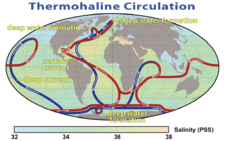
Movement of thermohaline circulation
Formation and movement of the deep water masses at the North Atlantic Ocean, creates sinking water masses that fill the basin and flows very slowly into the deep abyssal plains of the Atlantic. This high latitude cooling and the low latitude heating drives the movement of the deep water in a polar southward flow. The deep water flows through the Antarctic Ocean Basin around South AfricaSouth Africa
The Republic of South Africa is a country in southern Africa. Located at the southern tip of Africa, it is divided into nine provinces, with of coastline on the Atlantic and Indian oceans...
where it is split into two routes: one into the Indian Ocean
Indian Ocean
The Indian Ocean is the third largest of the world's oceanic divisions, covering approximately 20% of the water on the Earth's surface. It is bounded on the north by the Indian Subcontinent and Arabian Peninsula ; on the west by eastern Africa; on the east by Indochina, the Sunda Islands, and...
and one past Australia
Australia
Australia , officially the Commonwealth of Australia, is a country in the Southern Hemisphere comprising the mainland of the Australian continent, the island of Tasmania, and numerous smaller islands in the Indian and Pacific Oceans. It is the world's sixth-largest country by total area...
into the Pacific.
At the Indian Ocean, some of the cold and salty water from the Atlantic — drawn by the flow of warmer and fresher upper ocean water from the tropical Pacific — causes a vertical exchange of dense, sinking water with lighter water above. It is known as overturning. In the Pacific Ocean, the rest of the cold and salty water from the Atlantic undergoes Haline forcing and faster becomes warmer and fresher.
The out-flowing undersea of cold and salty water makes the sea level of the Atlantic slightly lower than the Pacific and salinity or halinity of water at the Atlantic higher than the Pacific. This generates a large but slow flow of warmer and fresher upper ocean water from the tropical Pacific to the Indian Ocean
Indian Ocean
The Indian Ocean is the third largest of the world's oceanic divisions, covering approximately 20% of the water on the Earth's surface. It is bounded on the north by the Indian Subcontinent and Arabian Peninsula ; on the west by eastern Africa; on the east by Indochina, the Sunda Islands, and...
through the Indonesian Archipelago to replace the cold and salty Antarctic Bottom Water
Antarctic Bottom Water
The 'Antarctic Bottom Water' is a type of water mass in the seas surrounding Antarctica with temperatures ranging from 0 to -0.8◦ C, salinities from 34.6 to 34.7 psu, and a density near 27.88...
. This is also known as 'Haline forcing' (net high latitude freshwater gain and low latitude evaporation). This warmer, fresher water from the Pacific flows up through the South Atlantic to Greenland
Greenland
Greenland is an autonomous country within the Kingdom of Denmark, located between the Arctic and Atlantic Oceans, east of the Canadian Arctic Archipelago. Though physiographically a part of the continent of North America, Greenland has been politically and culturally associated with Europe for...
, where it cools off and undergoes evaporative cooling and sinks to the ocean floor, providing a continuous thermohaline circulation.
Hence, a recent and popular name for the thermohaline circulation, emphasizing the vertical nature and pole-to-pole character of this kind of ocean circulation, is the meridional overturning circulation.
Quantitative Estimation
The deep water masses that participate in the MOC have chemical, temperature and isotopic ratio signatures and can be traced, their flow rate calculated, and their age determined.These include 231Pa / 230Th
Isotope geochemistry
Isotope geochemistry is an aspect of geology based upon study of the relative and absolute concentrations of the elements and their isotopes in the Earth. Variations in the abundance of these isotopes, typically measured with an isotope ratio mass spectrometer or an accelerator mass spectrometer,...
ratios.
Gulf Stream
The North Atlantic CurrentNorth Atlantic Current
The North Atlantic Current is a powerful warm ocean current that continues the Gulf Stream northeast. West of Ireland it splits in two; one branch, the Canary Current, goes south, while the other continues north along the coast of northwestern Europe...
, warm ocean current that continues the Gulf Stream northeast, is largely driven by the global thermohaline circulation to further east and north from the North American coast, across the Atlantic and into the Arctic Ocean.
Upwelling
All these dense water masses sinking into the ocean basins displace the water below them, so that elsewhere water must be rising in order to maintain a balance. However, because this thermohaline upwelling is so widespread and diffuse, its speeds are very slow even compared to the movement of the bottom water masses. It is therefore difficult to measure where upwelling occurs using current speeds, given all the other wind-driven processes going on in the surface ocean. Deep waters do however have their own chemical signature, formed from the breakdown of particulate matter falling into them over the course of their long journey at depth; and a number of authors have tried to use these tracers to infer where the upwelling occurs.Wallace Broecker
Wallace S. Broecker
Wallace Smith Broecker is the Newberry Professor in the Department of Earth and Environmental Sciences at Columbia University and a scientist at Columbia's Lamont-Doherty Earth Observatory...
, using box models, has asserted that the bulk of deep upwelling occurs in the North Pacific, using as evidence the high values of silicon found in these waters. However, other investigators have not found such clear evidence. Computer models of ocean circulation increasingly place most of the deep upwelling in the Southern Ocean, associated with the strong winds in the open latitudes between South America and Antarctica. While this picture is consistent with the global observational synthesis of William Schmitz at Woods Hole and with low observed values of diffusion, not all observational syntheses agree. Recent papers by Lynne Talley
Lynne Talley
Lynne Talley is an American physical oceanographer.Talley is Professor of Physical Oceanography at Scripps Institution of Oceanography. She is a seagoing oceanographer and served as chief scientist on several hydrography cruises...
at the Scripps Institution of Oceanography
Scripps Institution of Oceanography
Scripps Institution of Oceanography in La Jolla, California, is one of the oldest and largest centers for ocean and earth science research, graduate training, and public service in the world...
and Bernadette Sloyan and Stephen Rintoul in Australia suggest that a significant amount of dense deep water must be transformed to light water somewhere north of the Southern Ocean.
Effects on global climate
The thermohaline circulation plays an important role in supplying heat to the polar regions, and thus in regulating the amount of sea ice in these regions, although poleward heat transport outside the tropics is considerably larger in the atmosphere than in the ocean. Changes in the thermohaline circulation are thought to have significant impacts on the Earth's radiation budget. Insofar as the thermohaline circulation governs the rate at which deep waters are exposed to the surface, it may also play an important role in determining the concentration of carbon dioxide in the atmosphere. While it is often stated that the thermohaline circulation is the primary reason that Western Europe is so temperate, it has been suggested that this is largely incorrect, and that Europe is warm mostly because it lies downwind of an ocean basin, and because of the effect of atmospheric waves bringing warm air north from the subtropicsSubtropics
The subtropics are the geographical and climatical zone of the Earth immediately north and south of the tropical zone, which is bounded by the Tropic of Cancer and the Tropic of Capricorn, at latitudes 23.5°N and 23.5°S...
. However, the underlying assumptions of this particular analysis have likewise been challenged.
Large influxes of low density meltwater from Lake Agassiz
Lake Agassiz
Lake Agassiz was an immense glacial lake located in the center of North America. Fed by glacial runoff at the end of the last glacial period, its area was larger than all of the modern Great Lakes combined, and it held more water than contained by all lakes in the world today.-Conception:First...
and deglaciation in North America
North America
North America is a continent wholly within the Northern Hemisphere and almost wholly within the Western Hemisphere. It is also considered a northern subcontinent of the Americas...
are thought to have led to a disruption of deep water formation and subsidence in the extreme North Atlantic and caused the climate period in Europe known as the Younger Dryas
Younger Dryas
The Younger Dryas stadial, also referred to as the Big Freeze, was a geologically brief period of cold climatic conditions and drought between approximately 12.8 and 11.5 ka BP, or 12,800 and 11,500 years before present...
.
See also
- Atlantic Multidecadal OscillationAtlantic Multidecadal OscillationThe Atlantic multidecadal oscillation is a mode of variability occurring in the North Atlantic Ocean and which has its principal expression in the sea surface temperature field...
(AMO) (in regard to "sea surface temperature") - Climate changeClimate changeClimate change is a significant and lasting change in the statistical distribution of weather patterns over periods ranging from decades to millions of years. It may be a change in average weather conditions or the distribution of events around that average...
- ContouriteContouriteA contourite is a sedimentary deposit produced by thermohaline-induced deepwater bottom currents and may be influenced by wind or tidal forces. Most contourites are formed in continental rise to lower slope settings, although they may occur anywhere that is below storm wave base...
- DownwellingDownwellingDownwelling is the process of accumulation and sinking of higher density material beneath lower density material, such as cold or saline water beneath warmer or fresher water or cold air beneath warm air. It is the sinking limb of a convection cell. Upwelling is the opposite process and together...
- Halothermal circulationHalothermal circulationThe term halothermal circulation refers to the part of the large-scale ocean circulation that is driven by global density gradients created by surface heat and evaporation....
- Hydrothermal circulationHydrothermal circulationHydrothermal circulation in its most general sense is the circulation of hot water; 'hydros' in the Greek meaning water and 'thermos' meaning heat. Hydrothermal circulation occurs most often in the vicinity of sources of heat within the Earth's crust...
- UpwellingUpwellingUpwelling is an oceanographic phenomenon that involves wind-driven motion of dense, cooler, and usually nutrient-rich water towards the ocean surface, replacing the warmer, usually nutrient-depleted surface water. The increased availability in upwelling regions results in high levels of primary...
- Shutdown of thermohaline circulationShutdown of thermohaline circulationShutdown or slowdown of the thermohaline circulation is a postulated effect of global warming.There is some speculation that global warming could, via a shutdown or slowdown of the thermohaline circulation, trigger localised cooling in the North Atlantic and lead to cooling, or lesser warming, in...