
Mount Tambora
Overview
Stratovolcano
A stratovolcano, also known as a composite volcano, is a tall, conical volcano built up by many layers of hardened lava, tephra, pumice, and volcanic ash. Unlike shield volcanoes, stratovolcanoes are characterized by a steep profile and periodic, explosive eruptions...
, also known as a composite volcano, on the island of Sumbawa
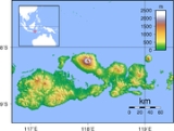
Sumbawa
Sumbawa is an Indonesian island, located in the middle of the Lesser Sunda Islands chain, with Lombok to the west, Flores to the east, and Sumba further to the southeast. It is in the province of West Nusa Tenggara....
, Indonesia
Indonesia
Indonesia , officially the Republic of Indonesia , is a country in Southeast Asia and Oceania. Indonesia is an archipelago comprising approximately 13,000 islands. It has 33 provinces with over 238 million people, and is the world's fourth most populous country. Indonesia is a republic, with an...
. Sumbawa is flanked both to the north and south by oceanic crust
Oceanic crust
Oceanic crust is the part of Earth's lithosphere that surfaces in the ocean basins. Oceanic crust is primarily composed of mafic rocks, or sima, which is rich in iron and magnesium...
, and Tambora was formed by the active subduction zone beneath it. This raised Mount Tambora as high as 4300 m (14,107.6 ft), making it formerly one of the tallest peaks in the Indonesian archipelago. After a large magma chamber
Magma chamber
A magma chamber is a large underground pool of molten rock found beneath the surface of the Earth. The molten rock in such a chamber is under great pressure, and given enough time, that pressure can gradually fracture the rock around it creating outlets for the magma...
inside the mountain filled over the course of several decades, volcanic activity reached a historic climax in the super-colossal eruption of April 1815.
The 1815 eruption is rated 7 on the Volcanic Explosivity Index
Volcanic Explosivity Index
The Volcanic Explosivity Index was devised by Chris Newhall of the U.S. Geological Survey and Stephen Self at the University of Hawaii in 1982 to provide a relative measure of the explosiveness of volcanic eruptions....
, the only such eruption since the Lake Taupo
Hatepe eruption
The Hatepe eruption around the year 180 CE was Lake Taupo's most recent major eruption, and New Zealand's largest eruption during the last 20,000 years. It ejected some of material , of which was ejected in the space of a few minutes...
eruption in about 180 AD.
Unanswered Questions