

Large igneous province
Encyclopedia
Igneous rock
Igneous rock is one of the three main rock types, the others being sedimentary and metamorphic rock. Igneous rock is formed through the cooling and solidification of magma or lava...
s—intrusive, extrusive, or both—in the earth's crust. In 1992 researchers first used the term 'large igneous province' to describe very large accumulations—areas greater than 100,000 square kilometers (slightly larger than the area of Portugal)— of mafic
Mafic
Mafic is an adjective describing a silicate mineral or rock that is rich in magnesium and iron; the term is a portmanteau of the words "magnesium" and "ferric". Most mafic minerals are dark in color and the relative density is greater than 3. Common rock-forming mafic minerals include olivine,...
igneous rocks that were erupted or emplaced at depth within an extremely short geological time interval—a few million years or less. Mafic, basalt sea floors and other geological products of 'normal' plate tectonics
Plate tectonics
Plate tectonics is a scientific theory that describes the large scale motions of Earth's lithosphere...
were not included in the definition.
The definition of 'LIP' has been expanded and refined, and is still a work in progress. 'LIP' is now frequently used to also describe voluminous areas of, not just mafic, but all types of igneous rocks. Sub-categorization of LIPs into Large Volcanic Provinces (LVP) and Large Plutonic Provinces (LPP), and including rocks produced by 'normal' plate tectonic processes, has been proposed.
The source of many or all LIPs are variously attributed to mantle plume
Mantle plume
A mantle plume is a hypothetical thermal diapir of abnormally hot rock that nucleates at the core-mantle boundary and rises through the Earth's mantle. Such plumes were invoked in 1971 to explain volcanic regions that were not thought to be explicable by the then-new theory of plate tectonics. Some...
s or to processes associated with plate tectonics.
Some LIPs are now intact, such the basaltic Deccan Traps
Deccan Traps
The Deccan Traps are a large igneous province located on the Deccan Plateau of west-central India and one of the largest volcanic features on Earth. They consist of multiple layers of solidified flood basalt that together are more than thick and cover an area of and a volume of...
in India, while others have been dismembered by plate tectonic motion, like the basaltic Central Atlantic Magmatic Province
Central Atlantic Magmatic Province
The Central Atlantic magmatic province is a large connected magma flow formed during the breakup of Pangaea during the Mesozoic Era. The initial breakup of Pangaea in early Jurassic time provided a legacy of basaltic dikes, sills, and lavas over a vast area around the present central North...
(CAMP)—parts of which are found in Brazil, eastern North America, and north-western Africa.
Motivations for study of LIPs
Large igneous provinces (LIPs) are created during short-lived igneous events resulting in relatively rapid and high-volume accumulations of volcanic and intrusive igneous rock. These events warrant study because:- The study of LIPs has economic implications. Some workers associate them with trapped hydrocarbons. They are associated with economic concentrations of copper–nickel and iron. They are also associated with formation of major mineral provinces including Platinum-Group Element (PGE) Deposits, and in the Silicic LIPs, silver and gold deposits. Titanium and vanadium deposits are also found in association with LIPs.
- Future LIP events may pose a hazard to human civilization. LIPs in the geological record have marked major changes in the hydrosphere and atmosphere, leading to major climate shifts and maybe mass extinctions of species.
- Plate tectonic theory explains topography using interactions between the tectonic plates, as influenced by viscous stresses created by flow within the underlying mantle. Since the mantle is extremely viscous, the mantle flow rate varies in pulses which are reflected in the lithosphere by small amplitude, long wavelength undulations. Understanding how the interaction between mantle flow and lithosphere elevation influences formation of LIPs is important to gaining insights into past mantle dynamics.
- LIPs have played a major role in continental breakup, continental formation, new crustal additions from the upper mantle, and supercontinent cycles.
Large Igneous Province formation
Ocean-plate creation at upwellings, spreading and subduction are well accepted fundamentals of plate tectonics, with the upwelling of hot mantle materials and the sinking of the cooler ocean plates driving the mantle convection. In this model, tectonic plates diverge at mid-ocean ridges, where hot mantle rock flows upward to fill the space. Plate-tectonic processes account for the vast majority of Earth’s volcanism.
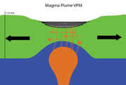
Beyond the effects of convectively driven motion, deep processes have other influences on the surface topography. The convective circulation drives up-wellings and down-wellings in Earth's mantle that are reflected in local surface levels. Hot mantle materials rising up in a plume can spread out radially beneath the tectonic plate causing regions of uplift. These ascending plumes play an important role in LIP formation.
Formation characteristics
When created, LIPs often have an areal extent of a few million km² and volumes on the order of 1 million km³. In most cases, the majority of a basaltic LIP's volume is emplaced in less than 1 million years. One of the conundra of such LIPs' origins is to understand how enormous volumes of basaltic magma are formed and erupted over such short time scales, with effusion rates up to an order of magnitude greater than mid-ocean ridge basalts.Formation theories
The source of many or all LIPs are variously attributed to mantle plumes, to processes associated with plate tectonics or to meteorite impacts.Plume formation of LIPs
Although most of volcanic activity on Earth is associated with subduction zones or mid-oceanic ridges, there are significant regions of long-lived, extensive volcanism, known as hot spots, which are only indirectly related to plate tectonics. The Emperor Sea Mount chain, located on the Pacific plate, is one example, tracing millions of years of relative motion as the plate moves over the Hawaiian hot spot. Numerous hot spots of varying size and age have been identified across the world. These hot spots move slowly with respect to one another, but move an order of magnitude more quickly with respect to tectonic plates, providing evidence that they are not directly linked to tectonic plates.The origin of hotspots remains controversial. Hotspots that reach the Earth’s surface may have three distinct origins. The deepest probably originate from the boundary between the lower mantle and the core; roughly 15-20% have characteristics such as presence of a linear chain of sea mounts with increasing ages, LIPs at the point of origin of the track, low shear wave velocity indicating high temperatures below the current location of the track, and ratios of He3 to He4 which are judged consistent with a deep origin. Others such as the Pitcairn, Samoan and Tahitian hotspots appear to originate at the top of large, transient, hot lava domes (termed superswells) in the mantle. The remainder appear to originate in the upper mantle and have been suggested to result from the breakup of subducting lithosphere.
Recent imaging of the region below known hot spots (e.g., Yellowstone and Hawaii) using seismic-wave tomography
Tomography
Tomography refers to imaging by sections or sectioning, through the use of any kind of penetrating wave. A device used in tomography is called a tomograph, while the image produced is a tomogram. The method is used in radiology, archaeology, biology, geophysics, oceanography, materials science,...
has produced mounting evidence that supports relatively narrow, deep-origin, convective plumes that are limited in region compared to the large-scale plate tectonic circulation in which they are imbedded. Images reveal continuous, but torturous vertical paths with varying quantities of elevated temperature material, particularly at elevations where crystallographic transformations are predicted to occur.
Plate-related stress formation of LIPs
A major alternative to the plume model is a model in which ruptures are caused by plate-related stresses that fractured the lithosphere, allowing melt to reach the surface from shallow heterogeneous sources. The high volumes of molten material that form the LIPs is postulated to be caused by convection in the upper mantle, which is secondary to the convection driving tectonic plate motion.Early-formed reservoir outpourings
It hass been proposed that geochemical evidence supports an early-formed reservoir that survived in the Earth’s mantle for about 4.5 billion years. Molten material is postulated to have originated from this reservoir, contributing the Baffin Island flood basalt ~60 million years ago. Basalts from the Ontong Java plateau show similar isotopic and trace element signatures proposed for the early-Earth reservoir.Meteorite-induced formation
Seven pairs of hotspots and LIPs located on opposite sides of the earth have been noted; analyses indicate this coincident antipodal location is highly unlikely to be random. The hotspot pairs include a large igneous province with continental volcanism opposite an oceanic hotspot. Oceanic impacts of large meteorites are expected to have high efficiency in converting energy into seismic waves. These waves would propagate around the world and reconverge close to the antipodal position; small variations are expected as the seismic velocity varies depending upon the route characteristics along which the waves propagate. As the waves focus on the antipodal position, they put the crust at the focal point under significant stress and are proposed to rupture it, creating antipodal pairs. When the meteorite impacts a continent, the lower efficiency of kinetic energy conversion into seismic energy is not expected to create an antipodal hotspot.A second impact-related model of hotspot and LIP formation has been suggested in which minor hotspot volcanism was generated at large-body impact sites and flood basalt volcanism was triggered antipodally by focused seismic energy [13,14]. This model has been challenged because impacts are generally considered seismically too inefficient [15], and the Deccan Traps of India were not antipodal to, and began erupting several Myr before, the end-Cretaceous Chicxulub impact in Mexico. In addition, no clear example of impact-induced volcanism, unrelated to melt sheets, has been confirmed at any known terrestrial crater.
Large Igneous Province classification
In 1992, Coffin and Eldholm initially defined the term “Large Igneous Province” (LIP) as representing a variety of mafic igneous provinces with areal extent >1 x 10⁵ km2 that represented “massive crustal emplacements of predominantly mafic (Mg- and Fe-rich) extrusive and intrusive rock, and originated via processes other than ‘normal’ seafloor spreading.” That original definition included continental flood basaltFlood basalt
A flood basalt or trap basalt is the result of a giant volcanic eruption or series of eruptions that coats large stretches of land or the ocean floor with basalt lava. Flood basalts have occurred on continental scales in prehistory, creating great plateaus and mountain ranges...
s, oceanic plateau
Oceanic plateau
An oceanic plateau is a large, relatively flat submarine region that rises well above the level of the ambient seabed. While many oceanic plateaus are composed of continental crust, and often form a step interrupting the continental slope, some plateaus are undersea remnants of large igneous...
s, large dike swarm
Dike swarm
A dike swarm or dyke swarm is a large geological structure consisting of a major group of parallel, linear, or radially oriented dikes intruded within continental crust. They consist of several to hundreds of dikes emplaced more or less contemporaneously during a single intrusive event and are...
s (the eroded roots of a volcanic province), and volcanic rifted margins
Passive margin
A passive margin is the transition between oceanic and continental crust which is not an active plate margin. It is constructed by sedimentation above an ancient rift, now marked by transitional crust. Continental rifting creates new ocean basins. Eventually the continental rift forms a mid-oceanic...
. Most of these LIPs consist of basalt, but some contain large volumes of associated rhyolite
Rhyolite
This page is about a volcanic rock. For the ghost town see Rhyolite, Nevada, and for the satellite system, see Rhyolite/Aquacade.Rhyolite is an igneous, volcanic rock, of felsic composition . It may have any texture from glassy to aphanitic to porphyritic...
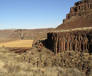
(e.g. the Columbia River Basalt Group
Columbia River Basalt Group
The Columbia River Basalt Group is a large igneous province that lies across parts of the Western United States. It is found in the U.S. states of Washington, Oregon, Idaho, Nevada, and California...
in the western United States); the rhyolite is typically very dry compared to island arc rhyolites, with much higher eruption temperatures (850°C to 1000°C) than normal rhyolites.
Since 1992 the definition of 'LIP' has been expanded and refined, and remains a work in progress. Some new definitions of the term 'LIP' include large granitic provinces such as those found in the Andes Mountains of South America and in western North America. Comprehensive taxonomies have been developed to focus technical discussions.
In 2008, Bryan and Ernst refined the definition to narrow it somewhat: “Large Igneous Provinces are magmatic provinces with areal extents >1 x 10⁵ km2, igneous volumes >1 x 10⁵ km3 and maximum lifespans of ∼50 Myr that have intraplate tectonic settings or geochemical affinities, and are characterised by igneous pulse(s) of short duration (∼1–5 Myr), during which a large proportion (>75%) of the total igneous volume has been emplaced. They are dominantly mafic, but also can have significant ultramafic and silicic components, and some are dominated by silicic magmatism." This definition places emphasis on the high magma emplacement rate characteristics of the LIP event and excludes seamounts, seamount groups, submarine ridges and anomalous seafloor crust.
'LIP' is now frequently used to also describe voluminous areas of, not just mafic, but all types of igneous rocks. Sub-categorization of LIPs into Large Volcanic Provinces (LVP) and Large Plutonic Provinces (LPP), and including rocks produced by 'normal' plate tectonic processes, has been proposed. Further, the threshold to be included as a LIP has been lowered to >5x10⁴ km2. The working taxonomy, focused heavily on geochemistry, which will be used to structure examples below, is:
- Large Igneous Provinces (LIP)
-
-
- Large Volcanic Provinces (LVP)
-
- Large Rhyolitic Provinces (LRPs)
- Large Andesitic Provinces (LAPs)
- Large Basaltic Provinces (LBPs)
-
- Continental Flood Basalts
- Oceanic Flood Basalts
- Large Basaltic–Rhyolitic Provinces (LBRPs)
- Large Plutonic Provinces (LPP)
-
- Large Granitic Provinces (LGP)
- Large Mafic Plutonic Provinces
-
Aerally extensive dike swarm
Dike swarm
A dike swarm or dyke swarm is a large geological structure consisting of a major group of parallel, linear, or radially oriented dikes intruded within continental crust. They consist of several to hundreds of dikes emplaced more or less contemporaneously during a single intrusive event and are...
s, sill
Sill (geology)
In geology, a sill is a tabular sheet intrusion that has intruded between older layers of sedimentary rock, beds of volcanic lava or tuff, or even along the direction of foliation in metamorphic rock. The term sill is synonymous with concordant intrusive sheet...
provinces, and large layered ultramafic intrusions are indicators of LIPs, even when other evidence is not now observable. The upper basalt layers of older LIPs may have been removed by erosion or deformed by tectonic plate collisions occurring after the layer is formed. The is especially likely for earlier periods such as the Paleozoic
Paleozoic
The Paleozoic era is the earliest of three geologic eras of the Phanerozoic eon, spanning from roughly...
and Proterozoic
Proterozoic
The Proterozoic is a geological eon representing a period before the first abundant complex life on Earth. The name Proterozoic comes from the Greek "earlier life"...
.
Giant dyke swarms having lengths >300 km (Ernst and Buchan, 1997) are a common record of severely eroded LIPs. Both radial and linear dyke swarm configurations exist. Radial swarms with an areal extent >2000 km and linear swarms extending >1000 km are known. The linear dyke swarms often have a high proportion of dykes relative to country rocks, particularly when the width of the linear field is less than 100 km. The dykes have a typical width of 20-100 meters, although ultramafic dykes with widths greater than 1000 meters have been reported.
Dykes are typically sub-vertical to vertical. When upward flowing (dyke-forming) magma encounters horizontal boundaries or weakness's, such as between layers in a sedimentary deposit, the magma can flow horizontally creating a sill. Some sill provinces have areal extents >1000 km,
Correlation of hot-spots with large igneous provinces
The early volcanic activity of major hotspotsHotspot (geology)
The places known as hotspots or hot spots in geology are volcanic regions thought to be fed by underlying mantle that is anomalously hot compared with the mantle elsewhere. They may be on, near to, or far from tectonic plate boundaries. There are two hypotheses to explain them...
, postulated to result from deep mantle plumes, is frequently accompanied by flood basalts. These flood basalt eruptions have resulted in large accumulations of basaltic lavas emplaced at a rate greatly exceeding that seen in contemporary volcanic processes. Continental rifting commonly follows flood basalt volcanism. Flood basalt provinces may also occur as a consequence of the initial hot-spot activity in ocean basins as well as on continents. It is possible to track the hot spot back to the flood basalts of a large igneous province; the table below correlates large igneous provinces with the track of a specific hot spot.
| Province | Region | Hotspot | Reference |
|---|---|---|---|
| Columbia River Basalt Columbia River Basalt Group The Columbia River Basalt Group is a large igneous province that lies across parts of the Western United States. It is found in the U.S. states of Washington, Oregon, Idaho, Nevada, and California... |
Northwestern USA | Yellowstone hotspot Yellowstone hotspot The Yellowstone hotspot, also referred to as the Snake River Plain-Yellowstone hotspot, is a volcanic hotspot responsible for large scale volcanism in Oregon, Nevada, Idaho, and Wyoming, United States. It created the eastern Snake River Plain through a succession of caldera forming eruptions... |
|
| Afro-Arabia | Yemen Yemen The Republic of Yemen , commonly known as Yemen , is a country located in the Middle East, occupying the southwestern to southern end of the Arabian Peninsula. It is bordered by Saudi Arabia to the north, the Red Sea to the west, and Oman to the east.... -Ethiopia Ethiopia Ethiopia , officially known as the Federal Democratic Republic of Ethiopia, is a country located in the Horn of Africa. It is the second-most populous nation in Africa, with over 82 million inhabitants, and the tenth-largest by area, occupying 1,100,000 km2... |
||
| North Atlantic Igneous Province North Atlantic Igneous Province The North Atlantic Igneous Province is a large igneous province estimated to be at least 1.3 km2 in area and 6.6 km3 in volume. Geographically, the NAIP makes up all of the North Atlantic Ocean as well as the Paleocene and Eocene basalts of Greenland, Iceland, the United Kingdom, Denmark, Norway... |
Northern Canada Canada Canada is a North American country consisting of ten provinces and three territories. Located in the northern part of the continent, it extends from the Atlantic Ocean in the east to the Pacific Ocean in the west, and northward into the Arctic Ocean... , Greenland Greenland Greenland is an autonomous country within the Kingdom of Denmark, located between the Arctic and Atlantic Oceans, east of the Canadian Arctic Archipelago. Though physiographically a part of the continent of North America, Greenland has been politically and culturally associated with Europe for... , the Faeroe Islands, Norway Norway Norway , officially the Kingdom of Norway, is a Nordic unitary constitutional monarchy whose territory comprises the western portion of the Scandinavian Peninsula, Jan Mayen, and the Arctic archipelago of Svalbard and Bouvet Island. Norway has a total area of and a population of about 4.9 million... , Ireland Ireland Ireland is an island to the northwest of continental Europe. It is the third-largest island in Europe and the twentieth-largest island on Earth... and Scotland Scotland Scotland is a country that is part of the United Kingdom. Occupying the northern third of the island of Great Britain, it shares a border with England to the south and is bounded by the North Sea to the east, the Atlantic Ocean to the north and west, and the North Channel and Irish Sea to the... |
Iceland Iceland Iceland , described as the Republic of Iceland, is a Nordic and European island country in the North Atlantic Ocean, on the Mid-Atlantic Ridge. Iceland also refers to the main island of the country, which contains almost all the population and almost all the land area. The country has a population... |
|
| Deccan Traps Deccan Traps The Deccan Traps are a large igneous province located on the Deccan Plateau of west-central India and one of the largest volcanic features on Earth. They consist of multiple layers of solidified flood basalt that together are more than thick and cover an area of and a volume of... |
India India India , officially the Republic of India , is a country in South Asia. It is the seventh-largest country by geographical area, the second-most populous country with over 1.2 billion people, and the most populous democracy in the world... & southern Pakistan Pakistan Pakistan , officially the Islamic Republic of Pakistan is a sovereign state in South Asia. It has a coastline along the Arabian Sea and the Gulf of Oman in the south and is bordered by Afghanistan and Iran in the west, India in the east and China in the far northeast. In the north, Tajikistan... |
Reunion Island | |
| Rahjamal Traps Rahjamal Traps The Rahjamal Traps are a volcanism episode in Bengal in India, associated with the Kerguelen "hot spot" of volcanic activity. At the time in question, c. 116–117 Ma, India in the southern Indian ocean over the Kerguelen hot spot; plate tectonics had not yet moved the Indian landmass into its... |
Eastern India India India , officially the Republic of India , is a country in South Asia. It is the seventh-largest country by geographical area, the second-most populous country with over 1.2 billion people, and the most populous democracy in the world... |
Ninety East Ridge Ninety East Ridge The Ninety East Ridge is a linear, aseismic, age-progressive seamount chain in the Indian Ocean and is named for its near-parallel strike along the 90th meridian... |
|
| Ontong-Java Plateau | Pacific Ocean | Louisville hotspot Louisville hotspot The Louisville hotspot is a volcanic hotspot responsible for the volcanic activity that has formed the Louisville seamount chain in the southern Pacific Ocean.-Location:... |
|
| Paraná and Etendeka traps Paraná and Etendeka traps The Paraná-Etendeka traps comprise a large igneous province which includes both the main Paraná traps as well as the smaller severed portions of the flood basalts at the Etendeka traps in Namibia and Angola. The original basalt flows occurred 128 to 138 million years ago... |
Brazil Brazil Brazil , officially the Federative Republic of Brazil , is the largest country in South America. It is the world's fifth largest country, both by geographical area and by population with over 192 million people... –Namibia Namibia Namibia, officially the Republic of Namibia , is a country in southern Africa whose western border is the Atlantic Ocean. It shares land borders with Angola and Zambia to the north, Botswana to the east and South Africa to the south and east. It gained independence from South Africa on 21 March... |
Tristan da Cunha Tristan da Cunha Tristan da Cunha is a remote volcanic group of islands in the south Atlantic Ocean and the main island of that group. It is the most remote inhabited archipelago in the world, lying from the nearest land, South Africa, and from South America... |
|
| Karoo-Ferrar Province Karoo-Ferrar Karoo and Ferrar denote a major geologic province consisting of flood basalt, which mostly covers South Africa and Antarctica, although portions extend further into southern Africa and into South America, India, Australia and New Zealand... |
South Africa South Africa The Republic of South Africa is a country in southern Africa. Located at the southern tip of Africa, it is divided into nine provinces, with of coastline on the Atlantic and Indian oceans... , Antarctica, Australia Australia Australia , officially the Commonwealth of Australia, is a country in the Southern Hemisphere comprising the mainland of the Australian continent, the island of Tasmania, and numerous smaller islands in the Indian and Pacific Oceans. It is the world's sixth-largest country by total area... & New Zealand New Zealand New Zealand is an island country in the south-western Pacific Ocean comprising two main landmasses and numerous smaller islands. The country is situated some east of Australia across the Tasman Sea, and roughly south of the Pacific island nations of New Caledonia, Fiji, and Tonga... |
Marion Island | |
| Caribbean large igneous province Caribbean large igneous province The Caribbean large igneous province consists of a major flood basalt, which created this large igneous province. It is the source of the current large eastern Pacific oceanic plateau, of which the Caribbean-Colombian oceanic plateau is the tectonized remnant. The deeper levels of the plateau have... |
Caribbean-Colombian oceanic plateau | Galápagos hotspot Galápagos hotspot The Galápagos hotspot is a volcanic hotspot in the East Pacific Ocean responsible for the creation of the Galapagos Islands as well as three major aseismic ridge systems, Carnegie, Cocos and Malpelso which are on two tectonic plates. The hotspot is located near the Equator on the Nazca Plate not... |
Relationship of LIPs to extinction events
Eruptions or emplacements of LIPs appear to have, in some cases, occurred simultaneously with oceanic anoxic events and extinction eventExtinction event
An extinction event is a sharp decrease in the diversity and abundance of macroscopic life. They occur when the rate of extinction increases with respect to the rate of speciation...
s. The most important examples are the Deccan Traps
Deccan Traps
The Deccan Traps are a large igneous province located on the Deccan Plateau of west-central India and one of the largest volcanic features on Earth. They consist of multiple layers of solidified flood basalt that together are more than thick and cover an area of and a volume of...
(Cretaceous–Tertiary extinction event), the Karoo-Ferrar
Karoo-Ferrar
Karoo and Ferrar denote a major geologic province consisting of flood basalt, which mostly covers South Africa and Antarctica, although portions extend further into southern Africa and into South America, India, Australia and New Zealand...
(Pliensbachian-Toarcian extinction), the Central Atlantic Magmatic Province
Central Atlantic Magmatic Province
The Central Atlantic magmatic province is a large connected magma flow formed during the breakup of Pangaea during the Mesozoic Era. The initial breakup of Pangaea in early Jurassic time provided a legacy of basaltic dikes, sills, and lavas over a vast area around the present central North...
(Triassic-Jurassic extinction event
Triassic-Jurassic extinction event
The Triassic–Jurassic extinction event marks the boundary between the Triassic and Jurassic periods, , and is one of the major extinction events of the Phanerozoic eon, profoundly affecting life on land and in the oceans. In the seas a whole class and twenty percent of all marine families...
), and the Siberian traps
Siberian Traps
The Siberian Traps form a large region of volcanic rock, known as a large igneous province, in the Russian region of Siberia. The massive eruptive event which formed the traps, one of the largest known volcanic events of the last 500 million years of Earth's geological history, continued for...
(Permian-Triassic extinction event
Permian-Triassic extinction event
The Permian–Triassic extinction event, informally known as the Great Dying, was an extinction event that occurred 252.28 Ma ago, forming the boundary between the Permian and Triassic geologic periods, as well as the Paleozoic and Mesozoic eras...
).
Several mechanisms are proposed to explain the association of LIPs with extinction events. The eruption of basaltic LIPs onto the earth's surface releases large volumes of sulfate gas, which forms sulfuric acid in the atmosphere; this absorbs heat and causes substantial cooling (e.g., the Laki
Laki (volcano)
Laki or Lakagígar is a volcanic fissure situated in the south of Iceland, not far from the canyon of Eldgjá and the small village Kirkjubæjarklaustur, in South-East Iceland....
eruption in Iceland, 1783). Oceanic LIPs can reduce oxygen in seawater by either direct oxidation reactions with metals in hydrothermal fluids or by causing algal blooms that consume large amounts of oxygen.
LIPs and Ore deposits
Large igneous provinces are associated with a handful of ore deposit types including:- NiNickelNickel is a chemical element with the chemical symbol Ni and atomic number 28. It is a silvery-white lustrous metal with a slight golden tinge. Nickel belongs to the transition metals and is hard and ductile...
-CuCopperCopper is a chemical element with the symbol Cu and atomic number 29. It is a ductile metal with very high thermal and electrical conductivity. Pure copper is soft and malleable; an exposed surface has a reddish-orange tarnish...
PGEPlatinum groupThe platinum group metals is a term used sometimes to collectively refer to six metallic elements clustered together in the periodic table.These elements are all transition metals, lying in the d-block .The six...
s - PorphyriesPorphyry (geology)Porphyry is a variety of igneous rock consisting of large-grained crystals, such as feldspar or quartz, dispersed in a fine-grained feldspathic matrix or groundmass. The larger crystals are called phenocrysts...
- Iron oxide copper gold (IOCG)Iron oxide copper gold ore depositsIron oxide copper gold ore deposits are important and highly valuable concentrations of copper, gold and uranium ores hosted within iron oxide dominant gangue assemblages which share a common genetic origin....
- KimberliteKimberliteKimberlite is a type of potassic volcanic rock best known for sometimes containing diamonds. It is named after the town of Kimberley in South Africa, where the discovery of an diamond in 1871 spawned a diamond rush, eventually creating the Big Hole....
s
Examples of Large Igneous Provinces
There are a number of well documented examples of large igneous provinces identified by geological research.| Province | Region | Age (Ma) | Area (106 km2 | Volume (106 km3 | Also known as or includes | Reference |
|---|---|---|---|---|---|---|
| Columbia River Basalt Columbia River Basalt Group The Columbia River Basalt Group is a large igneous province that lies across parts of the Western United States. It is found in the U.S. states of Washington, Oregon, Idaho, Nevada, and California... |
Northwestern USA | 17-to-6 | 0.16 | 0.175 | ||
| Afro-Arabia | Yemen Yemen The Republic of Yemen , commonly known as Yemen , is a country located in the Middle East, occupying the southwestern to southern end of the Arabian Peninsula. It is bordered by Saudi Arabia to the north, the Red Sea to the west, and Oman to the east.... -Ethiopia Ethiopia Ethiopia , officially known as the Federal Democratic Republic of Ethiopia, is a country located in the Horn of Africa. It is the second-most populous nation in Africa, with over 82 million inhabitants, and the tenth-largest by area, occupying 1,100,000 km2... |
31-to-25 | 0.6 | 0.35 | Ethiopia | |
| North Atlantic Igneous Province North Atlantic Igneous Province The North Atlantic Igneous Province is a large igneous province estimated to be at least 1.3 km2 in area and 6.6 km3 in volume. Geographically, the NAIP makes up all of the North Atlantic Ocean as well as the Paleocene and Eocene basalts of Greenland, Iceland, the United Kingdom, Denmark, Norway... |
Northern Canada Canada Canada is a North American country consisting of ten provinces and three territories. Located in the northern part of the continent, it extends from the Atlantic Ocean in the east to the Pacific Ocean in the west, and northward into the Arctic Ocean... , Greenland Greenland Greenland is an autonomous country within the Kingdom of Denmark, located between the Arctic and Atlantic Oceans, east of the Canadian Arctic Archipelago. Though physiographically a part of the continent of North America, Greenland has been politically and culturally associated with Europe for... , the Faeroe Islands, Norway Norway Norway , officially the Kingdom of Norway, is a Nordic unitary constitutional monarchy whose territory comprises the western portion of the Scandinavian Peninsula, Jan Mayen, and the Arctic archipelago of Svalbard and Bouvet Island. Norway has a total area of and a population of about 4.9 million... , Ireland Ireland Ireland is an island to the northwest of continental Europe. It is the third-largest island in Europe and the twentieth-largest island on Earth... and Scotland Scotland Scotland is a country that is part of the United Kingdom. Occupying the northern third of the island of Great Britain, it shares a border with England to the south and is bounded by the North Sea to the east, the Atlantic Ocean to the north and west, and the North Channel and Irish Sea to the... |
62-to-55 | 1.3 | 6.6 | High Arctic Large Igneous Province High Arctic Large Igneous Province The High Arctic Large Igneous Province is a major Late Cretaceous large igneous province located in the Arctic. It includes the Ellesmere Island Volcanics, Strand Fiord Formation, Alpha Ridge, Franz Josef Land and Svalbard.-See also:... Jameson Land Jameson Land Jameson Land is a peninsula in eastern Greenland, bounded to the southwest by Scoresby Sund , to the northwest by the Greenlandic mainland, to the north by Scoresby Land, and to the east by Carlsberg Fjord, Liverpool Land and Hurry Inlet.-Geology:Jameson Land mainly consists of a tilted peneplain... Thulean Plateau Thulean Plateau The Thulean Plateau also known as the Thulean Province, was a great basaltic lava plain that existed during the Paleogene Period, which possibly extended over 1,800,000 km2 in the northern Atlantic Ocean region... |
|
| Deccan Traps Deccan Traps The Deccan Traps are a large igneous province located on the Deccan Plateau of west-central India and one of the largest volcanic features on Earth. They consist of multiple layers of solidified flood basalt that together are more than thick and cover an area of and a volume of... |
India India India , officially the Republic of India , is a country in South Asia. It is the seventh-largest country by geographical area, the second-most populous country with over 1.2 billion people, and the most populous democracy in the world... & southern Pakistan Pakistan Pakistan , officially the Islamic Republic of Pakistan is a sovereign state in South Asia. It has a coastline along the Arabian Sea and the Gulf of Oman in the south and is bordered by Afghanistan and Iran in the west, India in the east and China in the far northeast. In the north, Tajikistan... |
65.5 | 0.5 - 0.8 | 0.5 - 1 | | | |
| Madagascar Madagascar The Republic of Madagascar is an island country located in the Indian Ocean off the southeastern coast of Africa... |
88 | |||||
| Rajmahal Traps Rajmahal Rajmahal is a city and a notified area in Sahibganj district in the Indian state of Jharkhand. Rajmahal is the only sub-divisional town in Sahibganj district. It is one of the most historic place in Jharkhand... |
116 | |||||
| Ontong-Java Plateau | Pacific Ocean | ~122 | 1.86 | 8.4 | Manihiki Plateau Manihiki Plateau The Manihiki Plateau is an oceanic plateau in the southwest Pacific Ocean. The Manihiki Plateau was formed by volcanic activity 125 to 120 million years ago during the mid-Cretaceous period at a triple junction plate boundary called the Tongareva triple junction.... and Hikurangi Plateau Hikurangi Plateau Hikurangi Plateau is an Early Cretaceous basaltic oceanic plateau in the southwestern Pacific Ocean. The portion of the plateau exposed on the seafloor has an area of 350,000 km2, and including the portions subducted beneath the... |
|
| Paraná and Etendeka traps Paraná and Etendeka traps The Paraná-Etendeka traps comprise a large igneous province which includes both the main Paraná traps as well as the smaller severed portions of the flood basalts at the Etendeka traps in Namibia and Angola. The original basalt flows occurred 128 to 138 million years ago... |
Brazil–Namibia | 134-to-129 | 1.5 | >1 | Equatorial Atlantic Magmatic Province Brazilian Highlands Brazilian Highlands The Brazilian Highlands or Brazilian Plateau are an extensive geographical region, covering most of the eastern, southern and central portions of Brazil, in all approximately half of the country's land area, or some 4,500,000 km²... |
|
| Karoo-Ferrar Province Karoo-Ferrar Karoo and Ferrar denote a major geologic province consisting of flood basalt, which mostly covers South Africa and Antarctica, although portions extend further into southern Africa and into South America, India, Australia and New Zealand... |
South Africa South Africa The Republic of South Africa is a country in southern Africa. Located at the southern tip of Africa, it is divided into nine provinces, with of coastline on the Atlantic and Indian oceans... , Antarctica, Australia Australia Australia , officially the Commonwealth of Australia, is a country in the Southern Hemisphere comprising the mainland of the Australian continent, the island of Tasmania, and numerous smaller islands in the Indian and Pacific Oceans. It is the world's sixth-largest country by total area... & New Zealand New Zealand New Zealand is an island country in the south-western Pacific Ocean comprising two main landmasses and numerous smaller islands. The country is situated some east of Australia across the Tasman Sea, and roughly south of the Pacific island nations of New Caledonia, Fiji, and Tonga... |
183-to-180 | 0.15-to-2 | 0.3 | ||
| Siberian Traps Siberian Traps The Siberian Traps form a large region of volcanic rock, known as a large igneous province, in the Russian region of Siberia. The massive eruptive event which formed the traps, one of the largest known volcanic events of the last 500 million years of Earth's geological history, continued for... |
Russia | 250 | 1.5 - 3.9 | 0.9 - >2 | ||
| Emeishan Traps Emeishan Traps The Emeishan Traps constitute a flood basalt volcanic province, or large igneous province, in southwestern China, centered in Sichuan province. It is sometimes referred to as the Permian Emeishan Large Igneous Province or variations of that term.... |
Southwestern China | 253-to-250 | 0.25 | ~0.3 | ||
| Warakurna large igneous province | Australia | 1078-to-1073 | 1.5 | Eastern Pilbara |
Large Rhyolitic Provinces (LRPs)
These LIPs are composed dominantly of felsicFelsic
The word "felsic" is a term used in geology to refer to silicate minerals, magma, and rocks which are enriched in the lighter elements such as silicon, oxygen, aluminium, sodium, and potassium....
materials. Examples include:
- Whitsunday
- Sierra Madre Occidental (Mexico)
- Malani
- Chon Aike (Argentina)
- Gawler (Australia)
Large Andesitic Provinces (LAPs)
These LIPs are comprised dominantly of andesitic materials. Examples include:- Island arcs such as Indonesia & Japan
- Active continental margins such as the Andes and the Cascades
- Continental collision zones such as the Anatolia-Iran zone
- High Arctic Large Igneous ProvinceHigh Arctic Large Igneous ProvinceThe High Arctic Large Igneous Province is a major Late Cretaceous large igneous province located in the Arctic. It includes the Ellesmere Island Volcanics, Strand Fiord Formation, Alpha Ridge, Franz Josef Land and Svalbard.-See also:...
(includes the Ellesmere Island VolcanicsEllesmere Island VolcanicsThe Ellesmere Island Volcanics are a Late Cretaceous volcanic group of volcanoes and lava flows in the Qikiqtaaluk Region of northern Ellesmere Island, Nunavut, Canada.Ellesmere Island Volcanics are part of the Arctic Cordillera...
, Strand Fiord FormationStrand Fiord FormationThe Strand Fiord Formation is a Late Cretaceous volcanic component, located on northwestern and west-central Axel Heiberg Island, Nunavut, Canada. The formation contains flood basalts which are found on western Axel Heiberg Island at Dragon Cliffs tall....
, Alpha RidgeAlpha RidgeThe Alpha Ridge is a major volcanic ridge under the Arctic Ocean between the Canada Basin and the Lomonosov Ridge. It was active during the formation of the Amerasian Basin. It was discovered in 1963. The highest elevation is about 2.7 km over the ocean floor. It is 200 to 450 km wide...
, Franz Josef LandFranz Josef LandFranz Josef Land, Franz Joseph Land, or Francis Joseph's Land is an archipelago located in the far north of Russia. It is found in the Arctic Ocean north of Novaya Zemlya and east of Svalbard, and is administered by Arkhangelsk Oblast. Franz Josef Land consists of 191 ice-covered islands with a...
and SvalbardSvalbardSvalbard is an archipelago in the Arctic, constituting the northernmost part of Norway. It is located north of mainland Europe, midway between mainland Norway and the North Pole. The group of islands range from 74° to 81° north latitude , and from 10° to 35° east longitude. Spitsbergen is the...
.) - North Atlantic Igneous ProvinceNorth Atlantic Igneous ProvinceThe North Atlantic Igneous Province is a large igneous province estimated to be at least 1.3 km2 in area and 6.6 km3 in volume. Geographically, the NAIP makes up all of the North Atlantic Ocean as well as the Paleocene and Eocene basalts of Greenland, Iceland, the United Kingdom, Denmark, Norway...
(includes basalts in Greenland, Iceland, Ireland, Scotland, Faroes)
Large Basaltic Provinces (LBPs)
This subcategory includes most of the provinces included in the original LIP classifications. It is composed of continental flood basalts, oceanic flood basalts, and diffuse provinces.Continental Flood Basalts
- Ethiopian HighlandsEthiopian HighlandsThe Ethiopian Highlands are a rugged mass of mountains in Ethiopia, Eritrea , and northern Somalia in the Horn of Africa...
- Columbia River Basalt GroupColumbia River Basalt GroupThe Columbia River Basalt Group is a large igneous province that lies across parts of the Western United States. It is found in the U.S. states of Washington, Oregon, Idaho, Nevada, and California...
- Deccan TrapsDeccan TrapsThe Deccan Traps are a large igneous province located on the Deccan Plateau of west-central India and one of the largest volcanic features on Earth. They consist of multiple layers of solidified flood basalt that together are more than thick and cover an area of and a volume of...
(India) - Coppermine River Group (Canadian Shield)
- Equatorial Atlantic Magmatic Province (MaranhãoMaranhãoMaranhão is a northeastern state of Brazil. To the north lies the Atlantic Ocean. Maranhão is neighbored by the states of Piauí, Tocantins and Pará. The people of Maranhão have a distinctive accent...
, Brazil-Ghana) - Paraná and Etendeka trapsParaná and Etendeka trapsThe Paraná-Etendeka traps comprise a large igneous province which includes both the main Paraná traps as well as the smaller severed portions of the flood basalts at the Etendeka traps in Namibia and Angola. The original basalt flows occurred 128 to 138 million years ago...
(ParanáParaná (state)Paraná is one of the states of Brazil, located in the South of the country, bordered on the north by São Paulo state, on the east by the Atlantic Ocean, on the south by Santa Catarina state and the Misiones Province of Argentina, and on the west by Mato Grosso do Sul and the republic of Paraguay,...
, Brazil-NE Namibia) - Brazilian HighlandsBrazilian HighlandsThe Brazilian Highlands or Brazilian Plateau are an extensive geographical region, covering most of the eastern, southern and central portions of Brazil, in all approximately half of the country's land area, or some 4,500,000 km²...
- Rio de la Plata CratonRio de la Plata CratonThe Río de la Plata craton is one of the five cratons of the South American continent. The other four cratons are: Amazonian, São Francisco, Río Apa and Arequipa–Antofalla.It crops out in southern Uruguay and parts of Argentina...
(Uruguay) - Karoo-FerrarKaroo-FerrarKaroo and Ferrar denote a major geologic province consisting of flood basalt, which mostly covers South Africa and Antarctica, although portions extend further into southern Africa and into South America, India, Australia and New Zealand...
(South Africa-Antarctica) - Siberian TrapsSiberian TrapsThe Siberian Traps form a large region of volcanic rock, known as a large igneous province, in the Russian region of Siberia. The massive eruptive event which formed the traps, one of the largest known volcanic events of the last 500 million years of Earth's geological history, continued for...
(Russia) - Emeishan TrapsEmeishan TrapsThe Emeishan Traps constitute a flood basalt volcanic province, or large igneous province, in southwestern China, centered in Sichuan province. It is sometimes referred to as the Permian Emeishan Large Igneous Province or variations of that term....
(western China) - Central Atlantic Magmatic ProvinceCentral Atlantic Magmatic ProvinceThe Central Atlantic magmatic province is a large connected magma flow formed during the breakup of Pangaea during the Mesozoic Era. The initial breakup of Pangaea in early Jurassic time provided a legacy of basaltic dikes, sills, and lavas over a vast area around the present central North...
(eastern United States and Canada, northern South America, northwest Africa)
Oceanic Flood Basalts/ Oceanic Plateaus
- Wrangellia TerraneWrangellia TerraneThe Wrangellia Terrane is a geologic concept encompassing a large arc of terrain extending from the U.S state of southcentral Alaska through southwestern Yukon and along the Coast of British Columbia in Canada...
(Alaska and Canada) - Caribbean large igneous provinceCaribbean large igneous provinceThe Caribbean large igneous province consists of a major flood basalt, which created this large igneous province. It is the source of the current large eastern Pacific oceanic plateau, of which the Caribbean-Colombian oceanic plateau is the tectonized remnant. The deeper levels of the plateau have...
(Caribbean Sea) - Kerguelen PlateauKerguelen PlateauThe Kerguelen Plateau is an underwater volcanic large igneous province , also the microcontinent and submerged continent in the southern Indian Ocean. It lies about 3,000 km to the southwest of Australia and is nearly three times the size of Japan...
(Indian Ocean) - Ontong Java PlateauOntong Java PlateauThe Ontong Java Plateau is a huge oceanic plateau located in the Pacific Ocean, lying north of the Solomon Islands. The plateau covers an area of approximately , or roughly the size of Alaska, and reaches a thickness of up to . The plateau is of volcanic origin, composed mostly of flood basalts...
, Manihiki PlateauManihiki PlateauThe Manihiki Plateau is an oceanic plateau in the southwest Pacific Ocean. The Manihiki Plateau was formed by volcanic activity 125 to 120 million years ago during the mid-Cretaceous period at a triple junction plate boundary called the Tongareva triple junction....
and Hikurangi PlateauHikurangi PlateauHikurangi Plateau is an Early Cretaceous basaltic oceanic plateau in the southwestern Pacific Ocean. The portion of the plateau exposed on the seafloor has an area of 350,000 km2, and including the portions subducted beneath the...
(southwest Pacific Ocean) - Jameson LandJameson LandJameson Land is a peninsula in eastern Greenland, bounded to the southwest by Scoresby Sund , to the northwest by the Greenlandic mainland, to the north by Scoresby Land, and to the east by Carlsberg Fjord, Liverpool Land and Hurry Inlet.-Geology:Jameson Land mainly consists of a tilted peneplain...
Large Basaltic–Rhyolitic Provinces (LBRPs)
- Snake River Plain – Oregon High Lava Plains
- Dongargarh (Ethiopia)
Large Granitic Provinces (LGP)
- Patagonia
- Peru-Chile Batholith
- Coast Range Batholith (NW USA)
Other Large Plutonic Provinces
- parts of Central Atlantic Magmatic ProvinceCentral Atlantic Magmatic ProvinceThe Central Atlantic magmatic province is a large connected magma flow formed during the breakup of Pangaea during the Mesozoic Era. The initial breakup of Pangaea in early Jurassic time provided a legacy of basaltic dikes, sills, and lavas over a vast area around the present central North...
(eastern United States and Canada, northern South America, northwest Africa)
Volcanic Rifted Margins
Volcanic passive margin
Volcanic passive margins and non-volcanic passive margins are the two forms of transitional crust that lie beneath passive continental margins that occur on Earth as the result of the formation of ocean basins via continental rifting. Initiation of igneous processes associated with volcanic...
are found on the boundary of large igneous provinces. Volcanic margins form when rifting is accompanied by significant mantle melting, with volcanism occurring before and/or during continental breakup. Volcanic rifted margins are characterized by: a transitional crust composed of basalt
Basalt
Basalt is a common extrusive volcanic rock. It is usually grey to black and fine-grained due to rapid cooling of lava at the surface of a planet. It may be porphyritic containing larger crystals in a fine matrix, or vesicular, or frothy scoria. Unweathered basalt is black or grey...
ic igneous rock
Igneous rock
Igneous rock is one of the three main rock types, the others being sedimentary and metamorphic rock. Igneous rock is formed through the cooling and solidification of magma or lava...
s, including lava
Lava
Lava refers both to molten rock expelled by a volcano during an eruption and the resulting rock after solidification and cooling. This molten rock is formed in the interior of some planets, including Earth, and some of their satellites. When first erupted from a volcanic vent, lava is a liquid at...
flows, sills
Sill (geology)
In geology, a sill is a tabular sheet intrusion that has intruded between older layers of sedimentary rock, beds of volcanic lava or tuff, or even along the direction of foliation in metamorphic rock. The term sill is synonymous with concordant intrusive sheet...
, dikes
Dike (geology)
A dike or dyke in geology is a type of sheet intrusion referring to any geologic body that cuts discordantly across* planar wall rock structures, such as bedding or foliation...
, and gabbro
Gabbro
Gabbro refers to a large group of dark, coarse-grained, intrusive mafic igneous rocks chemically equivalent to basalt. The rocks are plutonic, formed when molten magma is trapped beneath the Earth's surface and cools into a crystalline mass....
s, high volume basalt flows, seaward-dipping reflector sequences (SDRS) of basalt flows that were rotated during the early stages of breakup, limited passive-margin subsidence during and after breakup, and the presence of a lower crust with anomalously high seismic P-wave velocities in lower crustal bodies (LCBs), indicative of lower temperature, dense media.
Example of volcanic margins include:
- The Yemen margin
- The East Australian margin
- The West Indian margin
- The Hatton-Rockal margin
- The U.S East Coast
- The mid-Norwegian margin
- The Brazilian margins
- The Namibian margin
Dike Swarms
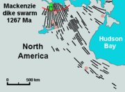
- Mackenzie dike swarmMackenzie dike swarmThe Mackenzie dike swarm, also called the Mackenzie dikes, form a large igneous province in the western Canadian Shield of Canada. It is part of the larger Mackenzie Large Igneous Province and is one of more than three dozen dike swarms in various parts of the Canadian Shield...
(Canadian Shield) - Long Range dikesLong Range dikesThe Long Range dikes are a Neoproterozoic mafic dike swarm of Newfoundland and Labrador, Canada. It consists of a large igneous province with an area of that was constructed about 620 million years ago. Its formation might have occurred when the ancient Iapetus Ocean began to form.-See...
(Newfoundland and Labrador, Canada) - Mistassini dike swarmMistassini dike swarmThe Mistassini dike swarm is a 2.5 billion year old Paleoproterozoic dike swarm of western Quebec, Canada. It consists of mafic dikes that were intruded in the Superior craton of the Canadian Shield...
(western Quebec, Canada) - Matachewan dike swarmMatachewan dike swarmThe Matachewan dike swarm is a large 2,500 to 2,450 million year old Paleoproterozoic dike swarm of Northern Ontario, Canada. It consists of basaltic dikes that were intruded in greenschist, granite-greenstone, and metamorphosed sedimentary terrains of the Superior craton of the Canadian Shield...
(northern Ontario, Canada) - Sorachi Plateau and Belt (Hokkaido, Japan)
Sills
A series of related sills that were formed essentially contemporaneously (with several million years) from related dikes comprise an LIP if their area is sufficiently large. Examples include:- Winagami sill complexWinagami sill complexThe Winagami sill complex, also called the Winagami sills, is a Paleoproterozoic large igneous province of northwestern Alberta, Canada. It consists of a series of related sills that were formed between 1.89 and 1.76 million years ago...
(northwestern Alberta, Canada) - Bushveld Igneous ComplexBushveld igneous complexThe Bushveld Igneous Complex is a large layered igneous intrusion within the Earth's crust which has been tilted and eroded and now outcrops around what appears to be the edge of a great geological basin, the Transvaal Basin. Located in South Africa, the BIC contains some of the richest ore...
(South Africa) with at area of over 66,000 km2 (25,000 sq mi), and a thickness reaching 9 kilometres (5.6 mi) thick.
See also
- Igneous rockIgneous rockIgneous rock is one of the three main rock types, the others being sedimentary and metamorphic rock. Igneous rock is formed through the cooling and solidification of magma or lava...
- Geologic provinceGeologic provinceA geologic or geomorphic province is a spatial entity with common geologic or geomorphic attributes. A province may include a single dominant structural element such as a basin or a fold belt, or a number of contiguous related elements...
- Mantle plumeMantle plumeA mantle plume is a hypothetical thermal diapir of abnormally hot rock that nucleates at the core-mantle boundary and rises through the Earth's mantle. Such plumes were invoked in 1971 to explain volcanic regions that were not thought to be explicable by the then-new theory of plate tectonics. Some...
s - HotspotsHotspot (geology)The places known as hotspots or hot spots in geology are volcanic regions thought to be fed by underlying mantle that is anomalously hot compared with the mantle elsewhere. They may be on, near to, or far from tectonic plate boundaries. There are two hypotheses to explain them...
- LithosphereLithosphereThe lithosphere is the rigid outermost shell of a rocky planet. On Earth, it comprises the crust and the portion of the upper mantle that behaves elastically on time scales of thousands of years or greater.- Earth's lithosphere :...
- Oceanic plateauOceanic plateauAn oceanic plateau is a large, relatively flat submarine region that rises well above the level of the ambient seabed. While many oceanic plateaus are composed of continental crust, and often form a step interrupting the continental slope, some plateaus are undersea remnants of large igneous...
- OrogenyOrogenyOrogeny refers to forces and events leading to a severe structural deformation of the Earth's crust due to the engagement of tectonic plates. Response to such engagement results in the formation of long tracts of highly deformed rock called orogens or orogenic belts...
- PeridotitePeridotiteA peridotite is a dense, coarse-grained igneous rock, consisting mostly of the minerals olivine and pyroxene. Peridotite is ultramafic, as the rock contains less than 45% silica. It is high in magnesium, reflecting the high proportions of magnesium-rich olivine, with appreciable iron...
- PlutonPlutonA pluton in geology is a body of intrusive igneous rock that crystallized from magma slowly cooling below the surface of the Earth. Plutons include batholiths, dikes, sills, laccoliths, lopoliths, and other igneous bodies...
- Subduction zone
- SupervolcanoSupervolcanoA supervolcano is a volcano capable of producing a volcanic eruption with an ejecta volume greater than 1,000 cubic kilometers . This is thousands of times larger than most historic volcanic eruptions. Supervolcanoes can occur when magma in the Earth rises into the crust from a hotspot but is...
- Volcanic passive marginVolcanic passive marginVolcanic passive margins and non-volcanic passive margins are the two forms of transitional crust that lie beneath passive continental margins that occur on Earth as the result of the formation of ocean basins via continental rifting. Initiation of igneous processes associated with volcanic...