

Hardiness zone
Encyclopedia
United States Department of Agriculture
The United States Department of Agriculture is the United States federal executive department responsible for developing and executing U.S. federal government policy on farming, agriculture, and food...
(USDA), the use of the zones has been adopted by other nations.
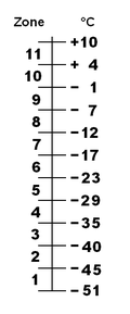
USDA Hardiness Zones
| Zone | From | To | |
| 0 | a | < −53.9 °C (−65 °F) | |
| b | −53.9 °C (−65 °F) | −51.1 °C (−60 °F) | |
| 1 | a | −51.1 °C (−60 °F) | −48.3 °C (−55 °F) |
| b | −48.3 °C (−55 °F) | −45.6 °C (−50 °F) | |
| 2 | a | −45.6 °C (−50 °F) | −42.8 °C (−45 °F) |
| b | −42.8 °C (−45 °F) | −40 °C (−40 °F) | |
| 3 | a | −40 °C (−40 °F) | −37.2 °C (−35 °F) |
| b | −37.2 °C (−35 °F) | −34.4 °C (−30 °F) | |
| 4 | a | −34.4 °C (−30 °F) | −31.7 °C (−25 °F) |
| b | −31.7 °C (−25 °F) | −28.9 °C (−20 °F) | |
| 5 | a | −28.9 °C (−20 °F) | −26.1 °C (−15 °F) |
| b | −26.1 °C (−15 °F) | −23.3 °C (−10 °F) | |
| 6 | a | −23.3 °C (−10 °F) | −20.6 °C (−5 °F) |
| b | −20.6 °C (−5 °F) | −17.8 °C (0 °F) | |
| 7 | a | −17.8 °C (0 °F) | −15 °C (5 °F) |
| b | −15 °C (5 °F) | −12.2 °C (10 °F) | |
| 8 | a | −12.2 °C (10 °F) | −9.4 °C (15 °F) |
| b | −9.4 °C (15 °F) | −6.7 °C (20 °F) | |
| 9 | a | −6.7 °C (20 °F) | −3.9 °C (25 °F) |
| b | −3.9 °C (25 °F) | −1.1 °C (30 °F) | |
| 10 | a | −1.1 °C (30 °F) | |
| b | |||
| 11 | a | ||
| b | |||
| 12 | a | ||
| b | > +12.8 °C (55 °F) | ||
Benefits and drawbacks
The hardiness zones are informative: the extremes of winter cold are a major determinant of whether a plant species can be cultivated outdoors at a particular location; however, the USDA hardiness zones have a number of drawbacks if used without supplementary information.The zones do not incorporate summer heat levels into the zone determination; thus sites which may have the same mean winter minima, but markedly different summer temperatures, will be accorded the same hardiness zone. An extreme example of this phenomenon is seen when comparing the Shetland Islands
Shetland Islands
Shetland is a subarctic archipelago of Scotland that lies north and east of mainland Great Britain. The islands lie some to the northeast of Orkney and southeast of the Faroe Islands and form part of the division between the Atlantic Ocean to the west and the North Sea to the east. The total...
and southern Alabama
Alabama
Alabama is a state located in the southeastern region of the United States. It is bordered by Tennessee to the north, Georgia to the east, Florida and the Gulf of Mexico to the south, and Mississippi to the west. Alabama ranks 30th in total land area and ranks second in the size of its inland...
, which are both on the boundary of zones 8 and 9 and share the same winter minima, but little else in their climates. In summer, the humid subtropical climate
Humid subtropical climate
A humid subtropical climate is a climate zone characterized by hot, humid summers and mild to cool winters...
of Alabama is about 20 degrees Celsius hotter than the Maritime Subarctic climate
Oceanic climate
An oceanic climate, also called marine west coast climate, maritime climate, Cascadian climate and British climate for Köppen climate classification Cfb and subtropical highland for Köppen Cfb or Cwb, is a type of climate typically found along the west coasts at the middle latitudes of some of the...
of Shetland, and there are few similar plants that can be grown at both locations. Due to its maritime climate, the UK is in AHS Heat Zone 2 (having 1 to 8 days hotter than 30 degrees Celsius) according to the AHS (American Horticultural Society
American Horticultural Society
The American Horticultural Society is a nonprofit, membership-based organization that promotes excellence in American horticulture. It is headquartered in Alexandria, Virginia....
), whereas Alabama is in Zones 7 to 9 (61 to 150 days hotter than 30 degrees Celsius). Users need to combine the hardiness zone with the heat zone to gain greater understanding of what can be grown in a particular location.
Another issue is that the hardiness zones do not take into account the reliability of the snow cover. Snow acts as an insulator against extreme cold, protecting the root system of hibernating plants. If the snow cover is reliable, the actual temperature to which the roots are exposed will not be as low as the hardiness zone number would indicate. As an example, Quebec City
Quebec City
Quebec , also Québec, Quebec City or Québec City is the capital of the Canadian province of Quebec and is located within the Capitale-Nationale region. It is the second most populous city in Quebec after Montreal, which is about to the southwest...
in Canada is located in zone 4, but can rely on an important snow cover every year, making it possible to cultivate plants normally rated for zones 5 or 6. But, in Montreal, located to the southwest in zone 5, it is sometimes difficult to cultivate plants adapted to the zone because of the unreliable snow cover.
Other factors that affect plant survival, though not considered in hardiness zones, are soil moisture, humidity, the number of days of frost, and the risk of a rare catastrophic cold snap. Some risk evaluation – the probability of getting a particularly severe low temperature – often would be more useful than just the average conditions.
Lastly, many plants may survive in a locality but will not flower if the day length is insufficient or if they require vernalization
Vernalization
Vernalization is the acquisition of a plant's ability to flower or germinate in the spring by exposure to the prolonged cold of winter...
(a particular duration of low temperature). With annuals, the time of planting can often be adjusted to allow growth beyond their normal geographical range.
An alternative means of describing plant hardiness is to use "indicator plants" (the USDA also publishes a list of these to go with the hardiness zone map). In this method, common plants with known limits to their range are used.
Gardening books are available that provide more information on climate zones. For example, Sunset Books (associated with Sunset Magazine) publishes a series that break up climate zones more finely than the USDA zones. They identify 45 distinct zones in the US, incorporating ranges of temperatures in all seasons, precipitation, wind patterns, elevation, and length and structure of the growing season.
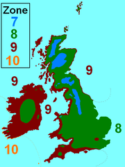
Britain and Ireland Hardiness Zones
Gulf Stream
The Gulf Stream, together with its northern extension towards Europe, the North Atlantic Drift, is a powerful, warm, and swift Atlantic ocean current that originates at the tip of Florida, and follows the eastern coastlines of the United States and Newfoundland before crossing the Atlantic Ocean...
on the Irish and British temperate
Temperate
In geography, temperate or tepid latitudes of the globe lie between the tropics and the polar circles. The changes in these regions between summer and winter are generally relatively moderate, rather than extreme hot or cold...
maritime climate, Britain, and Ireland even more so, have milder winters than their northerly position would otherwise entail. This means that the hardiness zones relevant to Britain and Ireland are quite high, from 7 to 10, as shown below.
- 7. In Scotland the Grampians, Highlands and locally in the Southern UplandsSouthern UplandsThe Southern Uplands are the southernmost and least populous of mainland Scotland's three major geographic areas . The term is used both to describe the geographical region and to collectively denote the various ranges of hills within this region...
, in England the PenninesPenninesThe Pennines are a low-rising mountain range, separating the North West of England from Yorkshire and the North East.Often described as the "backbone of England", they form a more-or-less continuous range stretching from the Peak District in Derbyshire, around the northern and eastern edges of...
and in Wales the highest part of SnowdoniaSnowdoniaSnowdonia is a region in north Wales and a national park of in area. It was the first to be designated of the three National Parks in Wales, in 1951.-Name and extent:...
. - 8. Most of England, Wales and Scotland, and parts of central Ireland.
- 9. Most of western and southern England and Wales, western Scotland, also a very narrow coastal fringe on the east coast of Scotland and northeast England (within 5 km of the North SeaNorth SeaIn the southwest, beyond the Straits of Dover, the North Sea becomes the English Channel connecting to the Atlantic Ocean. In the east, it connects to the Baltic Sea via the Skagerrak and Kattegat, narrow straits that separate Denmark from Norway and Sweden respectively...
), London, and most of Ireland. - 10. Very low lying coastal areas of the southwest of Ireland and the Isles of ScillyIsles of ScillyThe Isles of Scilly form an archipelago off the southwestern tip of the Cornish peninsula of Great Britain. The islands have had a unitary authority council since 1890, and are separate from the Cornwall unitary authority, but some services are combined with Cornwall and the islands are still part...
.
Central Europe Hardiness Zones
Central Europe's climate is a good example of a transition from an oceanic climateOceanic climate
An oceanic climate, also called marine west coast climate, maritime climate, Cascadian climate and British climate for Köppen climate classification Cfb and subtropical highland for Köppen Cfb or Cwb, is a type of climate typically found along the west coasts at the middle latitudes of some of the...
to a continental climate
Continental climate
Continental climate is a climate characterized by important annual variation in temperature due to the lack of significant bodies of water nearby...
, which can be noticed immediately when looking at the hardiness zones, which tend to decrease mainly eastwards instead of northwards. Also, the plateaux and low mountain ranges in this region have a significant impact on how cold it might get during winter. Generally speaking, the hardiness zones are high considering the latitude of the region, although not as high as in the Shetland Islands where zone 9 extends to over 60°N. In Central Europe, the relevant zones decrease from zone 8 on the Belgian and Dutch coasts, as well as some of the Frisian Islands
Frisian Islands
The Frisian Islands, also known as the Wadden Islands or Wadden Sea Islands, form an archipelago at the eastern edge of the North Sea in northwestern Europe, stretching from the north-west of the Netherlands through Germany to the west of Denmark...
and the island of Heligoland
Heligoland
Heligoland is a small German archipelago in the North Sea.Formerly Danish and British possessions, the islands are located in the Heligoland Bight in the south-eastern corner of the North Sea...
, to zone 5 on the far eastern border between Poland and Belarus. Some isolated, high elevation areas of the Alps
Alps
The Alps is one of the great mountain range systems of Europe, stretching from Austria and Slovenia in the east through Italy, Switzerland, Liechtenstein and Germany to France in the west....
and Carpathians may even go down to zone 3 or 4. An extreme example of a cold sink is Funtensee
Funtensee
Funtensee is a lake in the Steinernes Meer plateau in the Nationalpark Berchtesgaden, Bavaria, Germany located on the larger of the two sinkholes of the uvala, known for record low temperatures up to 30°C lower than the surrounding area. Its primary inflows are the Steingraben, Stuhlgraben and...
, Bavaria
Bavaria
Bavaria, formally the Free State of Bavaria is a state of Germany, located in the southeast of Germany. With an area of , it is the largest state by area, forming almost 20% of the total land area of Germany...
which is at least in zone 3 and maybe even in zone 2.
Northern Europe Hardiness Zones
Scandinavia lies at the same latitude as Alaska or Greenland, but the effect of the warm Gulf StreamGulf Stream
The Gulf Stream, together with its northern extension towards Europe, the North Atlantic Drift, is a powerful, warm, and swift Atlantic ocean current that originates at the tip of Florida, and follows the eastern coastlines of the United States and Newfoundland before crossing the Atlantic Ocean...
is even more pronounced here than it is in Britain and Ireland. Save for a very small spot near Karasjok
Karasjok
Kárášjohka or is a village and municipality in Finnmark county, Norway. The administrative centre of the municipality is the village of Karasjok.-Name:Karasjok is a Norwegianized form of the Sámi name Kárášjohka...
, Norway which is in zone 2, nowhere in the Arctic part of Scandinavia does it get below zone 3. The Faroe Islands
Faroe Islands
The Faroe Islands are an island group situated between the Norwegian Sea and the North Atlantic Ocean, approximately halfway between Scotland and Iceland. The Faroe Islands are a self-governing territory within the Kingdom of Denmark, along with Denmark proper and Greenland...
, at 62-63°N are in zone 8, as are the outer Lofoten Islands at 68°N. Tromsø
Tromsø
Tromsø is a city and municipality in Troms county, Norway. The administrative centre of the municipality is the city of Tromsø.Tromsø city is the ninth largest urban area in Norway by population, and the seventh largest city in Norway by population...
, a coastal city in Norway at 70°N, is in zone 7, and even Longyearbyen
Longyearbyen
Longyearbyen is the largest settlement and the administrative centre of Svalbard, Norway. It is located on the western coast of Spitsbergen, the largest island of the Svalbard archipelago, on the southern side on Adventfjorden , which continues inland with Adventdalen...
, the northernmost true city in the world at 78°N, is still in zone 5. All these coastal locations have one thing in common, though, which are cold, damp summers, with temperatures rarely exceeding 20°C, or 15°C in Longyearbyen. This shows the importance to take heat zones into account for a better understanding of what may or may not grow.
Karesuando
Karesuando is the northernmost locality situated in Kiruna Municipality, Norrbotten County, Sweden with 313 inhabitants in 2005....
, Pajala
Pajala
Pajala is a locality and the seat of Pajala Municipality in Norrbotten County, Sweden with 1,985 inhabitants in 2005.-History:Lars Levi Læstadius lived and worked in Pajala Municipality in the middle of the 19th century...
and Rovaniemi
Rovaniemi
Rovaniemi is a city and municipality of Finland. It is the administrative capital and commercial centre of Finland's northernmost province, Lapland. It is situated close to the Arctic Circle and is between the hills of Ounasvaara and Korkalovaara, at the confluence of the Kemijoki River and its...
. Kiruna
Kiruna
Kiruna is the northernmost city in Sweden, situated in Lapland province, with 18,154 inhabitants in 2005. It is the seat of Kiruna Municipality Kiruna (Northern Sami: Giron, Finnish: Kiiruna) is the northernmost city in Sweden, situated in Lapland province, with 18,154 inhabitants in 2005. It is...
is the big exception here, which being located on a hill above frost traps, is in zone 5. Zone 4 lies between the Arctic Circle and about 64-65°N, with cities such as Oulu
Oulu
Oulu is a city and municipality of inhabitants in the region of Northern Ostrobothnia, in Finland. It is the most populous city in Northern Finland and the sixth most populous city in the country. It is one of the northernmost larger cities in the world....
and Jokkmokk
Jokkmokk
Jokkmokk is a locality and the seat of Jokkmokk Municipality in Norrbotten County, Sweden with 2,976 inhabitants in 2005. The Sámi name of the place means "River's Curve", due to the meandering river that runs through it...
, Zone 5 (south to 61-62°N) contains cities such as Tampere
Tampere
Tampere is a city in southern Finland. It is the most populous inland city in any of the Nordic countries. The city has a population of , growing to approximately 300,000 people in the conurbation and over 340,000 in the metropolitan area. Tampere is the third most-populous municipality in...
, Umeå
Umeå
- Transport :The road infrastructure in Umeå is well-developed, with two European highways passing through the city. About 4 km from the city centre is the Umeå City Airport...
and Östersund
Östersund
Östersund is an urban area in Jämtland in the middle of Sweden. It is the seat of Östersund Municipality and the capital of Jämtland County. Östersund is located at the shores of Sweden's fifth largest lake, Storsjön, opposite the island Frösön, and is the only city in Jämtland. Östersund is the...
. Zone 6 covers the south of mainland Finland, Sweden north of 60°N, and the high plateau of Småland
Småland
' is a historical province in southern Sweden.Småland borders Blekinge, Scania or Skåne, Halland, Västergötland, Östergötland and the island Öland in the Baltic Sea. The name Småland literally means Small Lands. . The latinized form Smolandia has been used in other languages...
further south. Here one will find cities such as Gävle
Gävle
Gävle is a city in Sweden, the seat of Gävle Municipality and the capital of Gävleborg County. It had 71,033 inhabitants in 12/31 2010. It is the oldest city in the historical Norrland , having received its charter in 1446 from Christopher of Bavaria.-History:It is believed that the name Gävle...
, Örebro
Örebro
-Sites of interest:Örebro's old town Wadköping is located on the banks of Svartån . It contains many 18th and 19th century wooden houses, along with museums and exhibitions....
, Sundsvall
Sundsvall
-External links:* - Official site from Nordisk Familjebok - Sundsvalls tourist information bureau. - The alternative guide to Sundsvall. - Blog with photos from Sundsvall....
and Helsinki
Helsinki
Helsinki is the capital and largest city in Finland. It is in the region of Uusimaa, located in southern Finland, on the shore of the Gulf of Finland, an arm of the Baltic Sea. The population of the city of Helsinki is , making it by far the most populous municipality in Finland. Helsinki is...
. The Åland Islands
Åland Islands
The Åland Islands form an archipelago in the Baltic Sea. They are situated at the entrance to the Gulf of Bothnia and form an autonomous, demilitarised, monolingually Swedish-speaking region of Finland...
, as well as coastal Southern Sweden, and the Stockholm
Stockholm
Stockholm is the capital and the largest city of Sweden and constitutes the most populated urban area in Scandinavia. Stockholm is the most populous city in Sweden, with a population of 851,155 in the municipality , 1.37 million in the urban area , and around 2.1 million in the metropolitan area...
area are in zone 6. The west coast of Sweden (Gothenburg
Gothenburg
Gothenburg is the second-largest city in Sweden and the fifth-largest in the Nordic countries. Situated on the west coast of Sweden, the city proper has a population of 519,399, with 549,839 in the urban area and total of 937,015 inhabitants in the metropolitan area...
and southwards) enjoys particularly mild winters and lies in zone 7, therefore being friendly to some hardy exotic species (The Botanical Garden of Gothenburg), the southeast coast of Sweden has a colder winter due to the absence of the Gulf Stream.
European cities
The table herein provides hardiness zone data for some European cities (based on climatological data) http://www.gardenology.org/wiki/Hardiness_zone http://www.backyardgardener.com/zone/europezone.html:| City | Zone | City | Zone | |
|---|---|---|---|---|
| Amsterdam, The Netherlands Amsterdam Amsterdam is the largest city and the capital of the Netherlands. The current position of Amsterdam as capital city of the Kingdom of the Netherlands is governed by the constitution of August 24, 1815 and its successors. Amsterdam has a population of 783,364 within city limits, an urban population... |
8 | Antwerp, Belgium | 8 | |
| Belfast, Northern Ireland Belfast Belfast is the capital of and largest city in Northern Ireland. By population, it is the 14th biggest city in the United Kingdom and second biggest on the island of Ireland . It is the seat of the devolved government and legislative Northern Ireland Assembly... |
9 | Berlin, Germany Berlin Berlin is the capital city of Germany and is one of the 16 states of Germany. With a population of 3.45 million people, Berlin is Germany's largest city. It is the second most populous city proper and the seventh most populous urban area in the European Union... |
6b | |
| Bratislava, Slovakia Bratislava Bratislava is the capital of Slovakia and, with a population of about 431,000, also the country's largest city. Bratislava is in southwestern Slovakia on both banks of the Danube River. Bordering Austria and Hungary, it is the only national capital that borders two independent countries.Bratislava... |
5-6 | Bucharest, Romania Bucharest Bucharest is the capital municipality, cultural, industrial, and financial centre of Romania. It is the largest city in Romania, located in the southeast of the country, at , and lies on the banks of the Dâmbovița River.... |
6a | |
| Cardiff, Wales Cardiff Cardiff is the capital, largest city and most populous county of Wales and the 10th largest city in the United Kingdom. The city is Wales' chief commercial centre, the base for most national cultural and sporting institutions, the Welsh national media, and the seat of the National Assembly for... |
9 | Catania, Italy Catania Catania is an Italian city on the east coast of Sicily facing the Ionian Sea, between Messina and Syracuse. It is the capital of the homonymous province, and with 298,957 inhabitants it is the second-largest city in Sicily and the tenth in Italy.Catania is known to have a seismic history and... |
10 | |
| Copenhagen, Denmark Copenhagen Copenhagen is the capital and largest city of Denmark, with an urban population of 1,199,224 and a metropolitan population of 1,930,260 . With the completion of the transnational Øresund Bridge in 2000, Copenhagen has become the centre of the increasingly integrating Øresund Region... |
7a | Cork, Ireland Cork (city) Cork is the second largest city in the Republic of Ireland and the island of Ireland's third most populous city. It is the principal city and administrative centre of County Cork and the largest city in the province of Munster. Cork has a population of 119,418, while the addition of the suburban... |
9b | |
| Dublin, Ireland | 9 | Düsseldorf, Germany Düsseldorf Düsseldorf is the capital city of the German state of North Rhine-Westphalia and centre of the Rhine-Ruhr metropolitan region.Düsseldorf is an important international business and financial centre and renowned for its fashion and trade fairs. Located centrally within the European Megalopolis, the... |
7b | |
| Edinburgh, Scotland Edinburgh Edinburgh is the capital city of Scotland, the second largest city in Scotland, and the eighth most populous in the United Kingdom. The City of Edinburgh Council governs one of Scotland's 32 local government council areas. The council area includes urban Edinburgh and a rural area... |
8 | Gdańsk, Poland Gdansk Gdańsk is a Polish city on the Baltic coast, at the centre of the country's fourth-largest metropolitan area.The city lies on the southern edge of Gdańsk Bay , in a conurbation with the city of Gdynia, spa town of Sopot, and suburban communities, which together form a metropolitan area called the... |
7 | |
| Glasgow, Scotland Glasgow Glasgow is the largest city in Scotland and third most populous in the United Kingdom. The city is situated on the River Clyde in the country's west central lowlands... |
9a | Hamburg, Germany Hamburg -History:The first historic name for the city was, according to Claudius Ptolemy's reports, Treva.But the city takes its modern name, Hamburg, from the first permanent building on the site, a castle whose construction was ordered by the Emperor Charlemagne in AD 808... |
7 | |
| Helsinki, Finland Helsinki Helsinki is the capital and largest city in Finland. It is in the region of Uusimaa, located in southern Finland, on the shore of the Gulf of Finland, an arm of the Baltic Sea. The population of the city of Helsinki is , making it by far the most populous municipality in Finland. Helsinki is... |
5b | Istanbul, Turkey Istanbul Istanbul , historically known as Byzantium and Constantinople , is the largest city of Turkey. Istanbul metropolitan province had 13.26 million people living in it as of December, 2010, which is 18% of Turkey's population and the 3rd largest metropolitan area in Europe after London and... |
8b | |
| Kaliningrad, Russia Kaliningrad Kaliningrad is a seaport and the administrative center of Kaliningrad Oblast, the Russian exclave between Poland and Lithuania on the Baltic Sea... |
6 | Kiev, Ukraine Kiev Kiev or Kyiv is the capital and the largest city of Ukraine, located in the north central part of the country on the Dnieper River. The population as of the 2001 census was 2,611,300. However, higher numbers have been cited in the press.... |
5 | |
| Kraków, Poland Kraków Kraków also Krakow, or Cracow , is the second largest and one of the oldest cities in Poland. Situated on the Vistula River in the Lesser Poland region, the city dates back to the 7th century. Kraków has traditionally been one of the leading centres of Polish academic, cultural, and artistic life... |
6 | Lisbon, Portugal Lisbon Lisbon is the capital city and largest city of Portugal with a population of 545,245 within its administrative limits on a land area of . The urban area of Lisbon extends beyond the administrative city limits with a population of 3 million on an area of , making it the 9th most populous urban... |
10a | |
| Ljubljana, Slovenia Ljubljana Ljubljana is the capital of Slovenia and its largest city. It is the centre of the City Municipality of Ljubljana. It is located in the centre of the country in the Ljubljana Basin, and is a mid-sized city of some 270,000 inhabitants... |
7 | London, England London London is the capital city of :England and the :United Kingdom, the largest metropolitan area in the United Kingdom, and the largest urban zone in the European Union by most measures. Located on the River Thames, London has been a major settlement for two millennia, its history going back to its... |
9a | |
| Madrid, Spain Madrid Madrid is the capital and largest city of Spain. The population of the city is roughly 3.3 million and the entire population of the Madrid metropolitan area is calculated to be 6.271 million. It is the third largest city in the European Union, after London and Berlin, and its metropolitan... |
8-9 | Málaga, Spain Málaga Málaga is a city and a municipality in the Autonomous Community of Andalusia, Spain. With a population of 568,507 in 2010, it is the second most populous city of Andalusia and the sixth largest in Spain. This is the southernmost large city in Europe... |
10b | |
| Marseille, France Marseille Marseille , known in antiquity as Massalia , is the second largest city in France, after Paris, with a population of 852,395 within its administrative limits on a land area of . The urban area of Marseille extends beyond the city limits with a population of over 1,420,000 on an area of... |
9 | Milan, Italy Milan Milan is the second-largest city in Italy and the capital city of the region of Lombardy and of the province of Milan. The city proper has a population of about 1.3 million, while its urban area, roughly coinciding with its administrative province and the bordering Province of Monza and Brianza ,... |
7-8 | |
| Minsk, Belarus Minsk - Ecological situation :The ecological situation is monitored by Republican Center of Radioactive and Environmental Control .During 2003–2008 the overall weight of contaminants increased from 186,000 to 247,400 tons. The change of gas as industrial fuel to mazut for financial reasons has worsened... |
4-5 | Moscow, Russia Moscow Moscow is the capital, the most populous city, and the most populous federal subject of Russia. The city is a major political, economic, cultural, scientific, religious, financial, educational, and transportation centre of Russia and the continent... |
4 | |
| Munich, Germany Munich Munich The city's motto is "" . Before 2006, it was "Weltstadt mit Herz" . Its native name, , is derived from the Old High German Munichen, meaning "by the monks' place". The city's name derives from the monks of the Benedictine order who founded the city; hence the monk depicted on the city's coat... |
6 | Murmansk, Russia Murmansk Murmansk is a city and the administrative center of Murmansk Oblast, Russia. It serves as a seaport and is located in the extreme northwest part of Russia, on the Kola Bay, from the Barents Sea on the northern shore of the Kola Peninsula, not far from Russia's borders with Norway and Finland... |
5 | |
| Nicosia, Cyprus Nicosia Nicosia from , known locally as Lefkosia , is the capital and largest city in Cyprus, as well as its main business center. Nicosia is the only divided capital in the world, with the southern and the northern portions divided by a Green Line... |
10b | Oslo, Norway Oslo Oslo is a municipality, as well as the capital and most populous city in Norway. As a municipality , it was established on 1 January 1838. Founded around 1048 by King Harald III of Norway, the city was largely destroyed by fire in 1624. The city was moved under the reign of Denmark–Norway's King... |
6 | |
| Simferopol, Ukraine Simferopol -Russian Empire and Civil War:The city was renamed Simferopol in 1784 after the annexation of the Crimean Khanate to the Russian Empire by Catherine II of Russia. The name Simferopol is derived from the Greek, Συμφερόπολις , translated as "the city of usefulness." In 1802, Simferopol became the... |
7b | Palma, Spain | 10 | |
| Paris, France Paris Paris is the capital and largest city in France, situated on the river Seine, in northern France, at the heart of the Île-de-France region... |
8a | Perm, Russia Perm Perm is a city and the administrative center of Perm Krai, Russia, located on the banks of the Kama River, in the European part of Russia near the Ural Mountains. From 1940 to 1957 it was named Molotov .... |
3 | |
| Prague, Czech Republic Prague Prague is the capital and largest city of the Czech Republic. Situated in the north-west of the country on the Vltava river, the city is home to about 1.3 million people, while its metropolitan area is estimated to have a population of over 2.3 million... |
6-7 | Reykjavík, Iceland Reykjavík Reykjavík is the capital and largest city in Iceland.Its latitude at 64°08' N makes it the world's northernmost capital of a sovereign state. It is located in southwestern Iceland, on the southern shore of Faxaflói Bay... |
7 | |
| Riga, Latvia Riga Riga is the capital and largest city of Latvia. With 702,891 inhabitants Riga is the largest city of the Baltic states, one of the largest cities in Northern Europe and home to more than one third of Latvia's population. The city is an important seaport and a major industrial, commercial,... |
5 | Rome, Italy Rome Rome is the capital of Italy and the country's largest and most populated city and comune, with over 2.7 million residents in . The city is located in the central-western portion of the Italian Peninsula, on the Tiber River within the Lazio region of Italy.Rome's history spans two and a half... |
9b | |
| Rovaniemi, Finland Rovaniemi Rovaniemi is a city and municipality of Finland. It is the administrative capital and commercial centre of Finland's northernmost province, Lapland. It is situated close to the Arctic Circle and is between the hills of Ounasvaara and Korkalovaara, at the confluence of the Kemijoki River and its... |
4 | Saint Petersburg, Russia Saint Petersburg Saint Petersburg is a city and a federal subject of Russia located on the Neva River at the head of the Gulf of Finland on the Baltic Sea... |
5a | |
| Sarajevo, Bosnia and Herzegovina Sarajevo Sarajevo |Bosnia]], surrounded by the Dinaric Alps and situated along the Miljacka River in the heart of Southeastern Europe and the Balkans.... |
7 | Santander, Spain Santander, Cantabria The port city of Santander is the capital of the autonomous community and historical region of Cantabria situated on the north coast of Spain. Located east of Gijón and west of Bilbao, the city has a population of 183,446 .-History:... |
10a | |
| Simrishamn, Sweden Simrishamn Simrishamn is a locality and the seat of Simrishamn Municipality, Skåne County, Sweden with 6,546 inhabitants in 2005. Simrishamn is, despite its small population, for historical reasons normally still referred to as a city.... |
8a | Sochi, Russia | 9 | |
| Sofia, Bulgaria Sofia Sofia is the capital and largest city of Bulgaria and the 12th largest city in the European Union with a population of 1.27 million people. It is located in western Bulgaria, at the foot of Mount Vitosha and approximately at the centre of the Balkan Peninsula.Prehistoric settlements were excavated... |
6 | Stockholm, Sweden Stockholm Stockholm is the capital and the largest city of Sweden and constitutes the most populated urban area in Scandinavia. Stockholm is the most populous city in Sweden, with a population of 851,155 in the municipality , 1.37 million in the urban area , and around 2.1 million in the metropolitan area... |
6a | |
| Strasbourg, France Strasbourg Strasbourg is the capital and principal city of the Alsace region in eastern France and is the official seat of the European Parliament. Located close to the border with Germany, it is the capital of the Bas-Rhin département. The city and the region of Alsace are historically German-speaking,... |
7 | Tallinn, Estonia Tallinn Tallinn is the capital and largest city of Estonia. It occupies an area of with a population of 414,940. It is situated on the northern coast of the country, on the banks of the Gulf of Finland, south of Helsinki, east of Stockholm and west of Saint Petersburg. Tallinn's Old Town is in the list... |
5 | |
| Tuapse, Russia | 8 | Tórshavn, Faroe Islands Tórshavn Tórshavn is the capital and largest town of the Faroe Islands. It is located in the southern part on the east coast of Streymoy. To the north west of the town lies the high mountain Húsareyn, and to the southwest, the high Kirkjubøreyn... |
7-8 | |
| Tromsø, Norway Tromsø Tromsø is a city and municipality in Troms county, Norway. The administrative centre of the municipality is the city of Tromsø.Tromsø city is the ninth largest urban area in Norway by population, and the seventh largest city in Norway by population... |
7 | Trondheim, Norway Trondheim Trondheim , historically, Nidaros and Trondhjem, is a city and municipality in Sør-Trøndelag county, Norway. With a population of 173,486, it is the third most populous municipality and city in the country, although the fourth largest metropolitan area. It is the administrative centre of... |
6 | |
| Umeå, Sweden Umeå - Transport :The road infrastructure in Umeå is well-developed, with two European highways passing through the city. About 4 km from the city centre is the Umeå City Airport... |
5 | Vienna, Austria Vienna Vienna is the capital and largest city of the Republic of Austria and one of the nine states of Austria. Vienna is Austria's primary city, with a population of about 1.723 million , and is by far the largest city in Austria, as well as its cultural, economic, and political centre... |
6 | |
| Vilnius, Lithuania Vilnius Vilnius is the capital of Lithuania, and its largest city, with a population of 560,190 as of 2010. It is the seat of the Vilnius city municipality and of the Vilnius district municipality. It is also the capital of Vilnius County... |
5 | Vorkuta, Russia Vorkuta Vorkuta is a coal-mining town in the Komi Republic, Russia, situated just north of the Arctic Circle in the Pechora coal basin at the Usa River. Population: - Labor camp origins :... |
2 | |
| Warsaw, Poland Warsaw Warsaw is the capital and largest city of Poland. It is located on the Vistula River, roughly from the Baltic Sea and from the Carpathian Mountains. Its population in 2010 was estimated at 1,716,855 residents with a greater metropolitan area of 2,631,902 residents, making Warsaw the 10th most... |
6 | Zürich, Switzerland Zürich Zurich is the largest city in Switzerland and the capital of the canton of Zurich. It is located in central Switzerland at the northwestern tip of Lake Zurich... |
7 |
North American hardiness zones
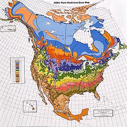
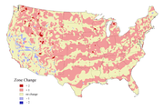
The USDA first issued its standardized hardiness zone map in 1960, and revised it in 1965. A new map was issued in 1990, based on U.S. and Canadian data from 1974 through 1986 (and 1971–1984 for Mexico). The 1990-issue map was based on nearly double the number of stations, and it divided the temperature zones into five-degree a/b zones for greater accuracy. This revised map identified many areas as colder than did the 1960 map, due chiefly to a number of severely colder winters in the central and eastern U.S. in the 1974–1986 data-gathering period, as opposed to the mid-20th century data-sampling period used in the 1960 map.
The 1990 map shows 10 different zones, each of which represents an area of winter hardiness for the plants of agriculture and the natural landscape. The USDA introduced zone 11, representing areas that have average annual minimum temperatures above 40 °F (4.4 °C) and that are therefore essentially frost-free.
Updates
American Horticultural Society
The American Horticultural Society is a nonprofit, membership-based organization that promotes excellence in American horticulture. It is headquartered in Alexandria, Virginia....
(AHS) produced a draft revised map, using temperature data collected from July 1986 to March 2002. This was a period of warmer winters than the 1974–1986 period, especially in the eastern U.S.A. The 2003 map placed many areas approximately a half-zone higher (warmer) than the 1990 map had. Reviewers noted the map zones appeared to be closer to the original 1960 map in its overall zone delineations. The 2003 AHS draft map purported to show finer detail, for example, reflecting urban heat island
Urban heat island
An urban heat island is a metropolitan area which is significantly warmer than its surrounding rural areas. The phenomenon was first investigated and described by Luke Howard in the 1810s, although he was not the one to name the phenomenon. The temperature difference usually is larger at night...
s by showing the downtown areas of several cities (e.g., Baltimore, Maryland, Washington, D.C.
Washington, D.C.
Washington, D.C., formally the District of Columbia and commonly referred to as Washington, "the District", or simply D.C., is the capital of the United States. On July 16, 1790, the United States Congress approved the creation of a permanent national capital as permitted by the U.S. Constitution....
and Atlantic City, New Jersey
Atlantic City, New Jersey
Atlantic City is a city in Atlantic County, New Jersey, United States, and a nationally renowned resort city for gambling, shopping and fine dining. The city also served as the inspiration for the American version of the board game Monopoly. Atlantic City is located on Absecon Island on the coast...
) as a full zone warmer than outlying areas. The map excluded the detailed a/b half-zones introduced in the 1990 map, an omission widely criticized by horticulturists and gardeners due to the coarseness of the resulting map. The USDA rejected the AHS 2003 draft map; the agency stated it would create its own map in an interactive computer format. As of August 2010 the AHS and the National Arboretum
National Arboretum
National Arboretum may refer to*National Arboretum Canberra in Australia*National Memorial Arboretum at Alrewas, UK*United States National Arboretum...
websites still present the 1990 map as current.
In 2006, the US National Arbor Day Foundation
National Arbor Day Foundation
The Arbor Day Foundation is the world's oldest and largest tree-planting organization. The foundation began September 3, 1971 with a mission "to inspire people to plant, nurture, and celebrate trees". The Foundation is supported by donations, selling trees and merchandise, and by corporate sponsors...
completed an extensive updating of U.S. Hardiness Zones. It used essentially the same data as the AHS. Once the Foundation analyzed the new data, it revised hardiness zones, reflecting the generally warmer recent temperatures in many parts of the country. The Foundation's 2006 map appears to validate the data used in the AHS 2003 draft. The Foundation also did away with the more detailed a/b half-zone delineations.
U.S. Cities hardiness zones
The USDA plant hardiness zones for U.S. cities as based on the draft 2003 map are the following:| City | Zone | City | Zone | |
|---|---|---|---|---|
| Albuquerque, New Mexico Albuquerque, New Mexico Albuquerque is the largest city in the state of New Mexico, United States. It is the county seat of Bernalillo County and is situated in the central part of the state, straddling the Rio Grande. The city population was 545,852 as of the 2010 Census and ranks as the 32nd-largest city in the U.S. As... |
7 | Oklahoma City, Oklahoma Oklahoma city Oklahoma City is the capital and largest city of the U.S. state of Oklahoma.Oklahoma City may also refer to:*Oklahoma City metropolitan area*Downtown Oklahoma City*Uptown Oklahoma City*Oklahoma City bombing*Oklahoma City National Memorial... |
7 | |
| Anchorage, Alaska Anchorage, Alaska Anchorage is a unified home rule municipality in the southcentral part of the U.S. state of Alaska. It is the northernmost major city in the United States... |
4 | Omaha, Nebraska Omaha, Nebraska Omaha is the largest city in the state of Nebraska, United States, and is the county seat of Douglas County. It is located in the Midwestern United States on the Missouri River, about 20 miles north of the mouth of the Platte River... |
5 | |
| Atlantic City, New Jersey Atlantic City, New Jersey Atlantic City is a city in Atlantic County, New Jersey, United States, and a nationally renowned resort city for gambling, shopping and fine dining. The city also served as the inspiration for the American version of the board game Monopoly. Atlantic City is located on Absecon Island on the coast... |
7-8 | Orlando, Florida Orlando, Florida Orlando is a city in the central region of the U.S. state of Florida. It is the county seat of Orange County, and the center of the Greater Orlando metropolitan area. According to the 2010 US Census, the city had a population of 238,300, making Orlando the 79th largest city in the United States... |
10 | |
| Atlanta, Georgia | 8 | Owensboro, Kentucky Owensboro, Kentucky Owensboro is the fourth largest city by population in the U.S. state of Kentucky. It is the county seat of Daviess County. It is located on U.S. Route 60 about southeast of Evansville, Indiana, and is the principal city of the Owensboro, Kentucky, Metropolitan Statistical Area. The city's... |
6 | |
| Baltimore, Maryland Baltimore Baltimore is the largest independent city in the United States and the largest city and cultural center of the US state of Maryland. The city is located in central Maryland along the tidal portion of the Patapsco River, an arm of the Chesapeake Bay. Baltimore is sometimes referred to as Baltimore... |
7-8 | Philadelphia, Pennsylvania Philadelphia, Pennsylvania Philadelphia is the largest city in the Commonwealth of Pennsylvania and the county seat of Philadelphia County, with which it is coterminous. The city is located in the Northeastern United States along the Delaware and Schuylkill rivers. It is the fifth-most-populous city in the United States,... |
6-7 | |
| Barnstable, Massachusetts Barnstable Barnstable may refer to:Places*Barnstable, Massachusetts, a US city*Barnstable , Massachusetts, a village within the city of Barnstable... |
6 | Phoenix, Arizona Phoenix, Arizona Phoenix is the capital, and largest city, of the U.S. state of Arizona, as well as the sixth most populated city in the United States. Phoenix is home to 1,445,632 people according to the official 2010 U.S. Census Bureau data... |
9 | |
| Boston, Massachusetts Boston Boston is the capital of and largest city in Massachusetts, and is one of the oldest cities in the United States. The largest city in New England, Boston is regarded as the unofficial "Capital of New England" for its economic and cultural impact on the entire New England region. The city proper had... |
6 | Pierre, South Dakota Pierre, South Dakota Pierre is the capital of the U.S. state of South Dakota and the county seat of Hughes County. The population was 13,646 at the 2010 census, making it the second least populous state capital after Montpelier, Vermont... |
5 | |
| Burlington, Vermont Burlington, Vermont Burlington is the largest city in the U.S. state of Vermont and the shire town of Chittenden County. Burlington lies south of the U.S.-Canadian border and some south of Montreal.... |
4 | Pittsburgh, Pennsylvania Pittsburgh, Pennsylvania Pittsburgh is the second-largest city in the US Commonwealth of Pennsylvania and the county seat of Allegheny County. Regionally, it anchors the largest urban area of Appalachia and the Ohio River Valley, and nationally, it is the 22nd-largest urban area in the United States... |
6 | |
| Chicago, Illinois Chicago Chicago is the largest city in the US state of Illinois. With nearly 2.7 million residents, it is the most populous city in the Midwestern United States and the third most populous in the US, after New York City and Los Angeles... |
5-6 | Portland, Maine Portland, Maine Portland is the largest city in Maine and is the county seat of Cumberland County. The 2010 city population was 66,194, growing 3 percent since the census of 2000... |
5 | |
| Charlotte, North Carolina CHARLOTTE - CHARLOTTE :CHARLOTTE is an American blues-based hard rock band that formed in Los Angeles, California in 1986. Currently, they are signed to indie label, Eonian Records, under which they released their debut cd, Medusa Groove, in 2010. Notable Charlotte songs include 'Siren', 'Little Devils',... |
7–8 | Portland, Oregon Portland, Oregon Portland is a city located in the Pacific Northwest, near the confluence of the Willamette and Columbia rivers in the U.S. state of Oregon. As of the 2010 Census, it had a population of 583,776, making it the 29th most populous city in the United States... |
8 | |
| Cleveland, Ohio | 5–6 | Providence, Rhode Island Providence, Rhode Island Providence is the capital and most populous city of Rhode Island and was one of the first cities established in the United States. Located in Providence County, it is the third largest city in the New England region... |
6 | |
| Dallas, Texas | 8 | Raleigh, North Carolina Raleigh, North Carolina Raleigh is the capital and the second largest city in the state of North Carolina as well as the seat of Wake County. Raleigh is known as the "City of Oaks" for its many oak trees. According to the U.S. Census Bureau, the city's 2010 population was 403,892, over an area of , making Raleigh... |
7-8 | |
| Denver, Colorado | 5 | Richmond, Virginia Richmond, Virginia Richmond is the capital of the Commonwealth of Virginia, in the United States. It is an independent city and not part of any county. Richmond is the center of the Richmond Metropolitan Statistical Area and the Greater Richmond area... |
7 | |
| Detroit, Michigan | 6 | St. Louis, Missouri St. Louis, Missouri St. Louis is an independent city on the eastern border of Missouri, United States. With a population of 319,294, it was the 58th-largest U.S. city at the 2010 U.S. Census. The Greater St... |
5-6 | |
| Fairbanks, Alaska Fairbanks, Alaska Fairbanks is a home rule city in and the borough seat of the Fairbanks North Star Borough in the U.S. state of Alaska.Fairbanks is the largest city in the Interior region of Alaska, and second largest in the state behind Anchorage... |
1 | Salt Lake City, Utah | 6-7 | |
| Hartford, Connecticut | 6 | San Antonio, Texas | 8-9 | |
| Honolulu, Hawaii | 11 | San Diego, California | 10 | |
| Houston, Texas | 8-9 | San Francisco, California | 8-9 | |
| Las Vegas, Nevada Las Vegas, Nevada Las Vegas is the most populous city in the U.S. state of Nevada and is also the county seat of Clark County, Nevada. Las Vegas is an internationally renowned major resort city for gambling, shopping, and fine dining. The city bills itself as The Entertainment Capital of the World, and is famous... |
8 | San Jose, California San Jose, California San Jose is the third-largest city in California, the tenth-largest in the U.S., and the county seat of Santa Clara County which is located at the southern end of San Francisco Bay... |
8-9 | |
| Los Angeles, California Los Ángeles Los Ángeles is the capital of the province of Biobío, in the commune of the same name, in Region VIII , in the center-south of Chile. It is located between the Laja and Biobío rivers. The population is 123,445 inhabitants... |
10 | Seattle, Washington | 7-8 | |
| Memphis, Tennessee Memphis, Tennessee Memphis is a city in the southwestern corner of the U.S. state of Tennessee, and the county seat of Shelby County. The city is located on the 4th Chickasaw Bluff, south of the confluence of the Wolf and Mississippi rivers.... |
7 | Tampa, Florida Tampa, Florida Tampa is a city in the U.S. state of Florida. It serves as the county seat for Hillsborough County. Tampa is located on the west coast of Florida. The population of Tampa in 2010 was 335,709.... |
9 | |
| Miami, Florida | 10 | Tucson, Arizona Tucson, Arizona Tucson is a city in and the county seat of Pima County, Arizona, United States. The city is located 118 miles southeast of Phoenix and 60 miles north of the U.S.-Mexico border. The 2010 United States Census puts the city's population at 520,116 with a metropolitan area population at 1,020,200... |
8 | |
| Minneapolis, Minnesota | 4 | Tulsa, Oklahoma Tulsa, Oklahoma Tulsa is the second-largest city in the state of Oklahoma and 46th-largest city in the United States. With a population of 391,906 as of the 2010 census, it is the principal municipality of the Tulsa Metropolitan Area, a region with 937,478 residents in the MSA and 988,454 in the CSA. Tulsa's... |
6-7 | |
| Nashville, Tennessee Nashville, Tennessee Nashville is the capital of the U.S. state of Tennessee and the county seat of Davidson County. It is located on the Cumberland River in Davidson County, in the north-central part of the state. The city is a center for the health care, publishing, banking and transportation industries, and is home... |
6-7 | Washington, D.C. | 7-8 | |
| New Orleans, Louisiana | 9 | Wichita, Kansas Wichita, Kansas Wichita is the largest city in the U.S. state of Kansas.As of the 2010 census, the city population was 382,368. Located in south-central Kansas on the Arkansas River, Wichita is the county seat of Sedgwick County and the principal city of the Wichita metropolitan area... |
6 | |
| New York City New York City New York is the most populous city in the United States and the center of the New York Metropolitan Area, one of the most populous metropolitan areas in the world. New York exerts a significant impact upon global commerce, finance, media, art, fashion, research, technology, education, and... |
7-8 | Newark, New Jersey Newark, New Jersey Newark is the largest city in the American state of New Jersey, and the seat of Essex County. As of the 2010 United States Census, Newark had a population of 277,140, maintaining its status as the largest municipality in New Jersey. It is the 68th largest city in the U.S... |
6 | |
| Wilmington, Delaware Wilmington, Delaware Wilmington is the largest city in the state of Delaware, United States, and is located at the confluence of the Christina River and Brandywine Creek, near where the Christina flows into the Delaware River. It is the county seat of New Castle County and one of the major cities in the Delaware Valley... |
7 | Trenton, New Jersey Trenton, New Jersey Trenton is the capital of the U.S. state of New Jersey and the county seat of Mercer County. As of the 2010 United States Census, Trenton had a population of 84,913... |
6-7 | |
Australian Hardiness Zones
The USDA hardiness zones are in use in Australia, but in addition the Australian National Botanic Gardens have devised another system more in keeping with Australian conditions. They are numerically about 7 lower than the USDA system. For example, Australian zone 3 is roughly equivalent to USDA zone 9. The higher Australian zone numbers have no US equivalents.There are problems with classifications of this type: the spread of weather stations is insufficient to give clear zones and too many places with different climates are lumped together. Only 738 Australian stations have records of more than ten years (one station per 98,491 hectares), though more populated areas have relatively fewer hectares per station. Local factors such as aspect, altitude, proximity to the sea also complicate the matter. For example, Mount Isa has three climatic stations with more than a ten year record. One is in Zone 4a, one in Zone 4b and the other is in Zone 5a. Likewise, Sydney residents can choose between Zones 3a and 4b. Most other cities have similar problems. Different locations in the same city are suitable for different plants, making it hard to draw a meaningful map. There may even be a case for publishing a list of weather stations and their zone classification to allow best use of local conditions.
AHS Heat Zones
In addition to the USDA Hardiness zones there are the American Horticultural SocietyAmerican Horticultural Society
The American Horticultural Society is a nonprofit, membership-based organization that promotes excellence in American horticulture. It is headquartered in Alexandria, Virginia....
(AHS) Heat Zones.
The criterion is the average number of days per year when the temperature exceeds 30°C(86°F) http://www.gardeningplaces.com/heatzonemap/. The AHS Heat Zone Map for the US is available here http://www.ahs.org/pdfs/05_heat_map.pdf.
| Zone | From | To |
| 1 | < 1 | |
| 2 | 1 | 7 |
| 3 | 8 | 14 |
| 4 | 15 | 30 |
| 5 | 31 | 45 |
| 6 | 46 | 60 |
| 7 | 61 | 90 |
| 8 | 91 | 120 |
| 9 | 121 | 150 |
| 10 | 151 | 180 |
| 11 | 181 | 210 |
| 12 | >210 | |
European cities (AHS Heat Zones)
| City | Zone | City | Zone | |
|---|---|---|---|---|
| Amsterdam, The Netherlands Amsterdam Amsterdam is the largest city and the capital of the Netherlands. The current position of Amsterdam as capital city of the Kingdom of the Netherlands is governed by the constitution of August 24, 1815 and its successors. Amsterdam has a population of 783,364 within city limits, an urban population... |
2 | Antwerp, Belgium | 2 | |
| Belfast, Northern Ireland Belfast Belfast is the capital of and largest city in Northern Ireland. By population, it is the 14th biggest city in the United Kingdom and second biggest on the island of Ireland . It is the seat of the devolved government and legislative Northern Ireland Assembly... |
1 | Berlin, Germany Berlin Berlin is the capital city of Germany and is one of the 16 states of Germany. With a population of 3.45 million people, Berlin is Germany's largest city. It is the second most populous city proper and the seventh most populous urban area in the European Union... |
3 | |
| Bratislava, Slovakia Bratislava Bratislava is the capital of Slovakia and, with a population of about 431,000, also the country's largest city. Bratislava is in southwestern Slovakia on both banks of the Danube River. Bordering Austria and Hungary, it is the only national capital that borders two independent countries.Bratislava... |
4 | Bucharest, Romania Bucharest Bucharest is the capital municipality, cultural, industrial, and financial centre of Romania. It is the largest city in Romania, located in the southeast of the country, at , and lies on the banks of the Dâmbovița River.... |
6 | |
| Cardiff, Wales Cardiff Cardiff is the capital, largest city and most populous county of Wales and the 10th largest city in the United Kingdom. The city is Wales' chief commercial centre, the base for most national cultural and sporting institutions, the Welsh national media, and the seat of the National Assembly for... |
1 | Catania, Italy Catania Catania is an Italian city on the east coast of Sicily facing the Ionian Sea, between Messina and Syracuse. It is the capital of the homonymous province, and with 298,957 inhabitants it is the second-largest city in Sicily and the tenth in Italy.Catania is known to have a seismic history and... |
8 | |
| Copenhagen, Denmark Copenhagen Copenhagen is the capital and largest city of Denmark, with an urban population of 1,199,224 and a metropolitan population of 1,930,260 . With the completion of the transnational Øresund Bridge in 2000, Copenhagen has become the centre of the increasingly integrating Øresund Region... |
2 | Cork, Ireland Cork (city) Cork is the second largest city in the Republic of Ireland and the island of Ireland's third most populous city. It is the principal city and administrative centre of County Cork and the largest city in the province of Munster. Cork has a population of 119,418, while the addition of the suburban... |
1 | |
| Derry, Northern Ireland Derry Derry or Londonderry is the second-biggest city in Northern Ireland and the fourth-biggest city on the island of Ireland. The name Derry is an anglicisation of the Irish name Doire or Doire Cholmcille meaning "oak-wood of Colmcille"... |
1 | Dublin, Ireland | 1 | |
| Düsseldorf, Germany Düsseldorf Düsseldorf is the capital city of the German state of North Rhine-Westphalia and centre of the Rhine-Ruhr metropolitan region.Düsseldorf is an important international business and financial centre and renowned for its fashion and trade fairs. Located centrally within the European Megalopolis, the... |
3 | Edinburgh, Scotland Edinburgh Edinburgh is the capital city of Scotland, the second largest city in Scotland, and the eighth most populous in the United Kingdom. The City of Edinburgh Council governs one of Scotland's 32 local government council areas. The council area includes urban Edinburgh and a rural area... |
1 | |
| Gdańsk, Poland Gdansk Gdańsk is a Polish city on the Baltic coast, at the centre of the country's fourth-largest metropolitan area.The city lies on the southern edge of Gdańsk Bay , in a conurbation with the city of Gdynia, spa town of Sopot, and suburban communities, which together form a metropolitan area called the... |
2 | Galway, Ireland Galway Galway or City of Galway is a city in County Galway, Republic of Ireland. It is the sixth largest and the fastest-growing city in Ireland. It is also the third largest city within the Republic and the only city in the Province of Connacht. Located on the west coast of Ireland, it sits on the... |
1 | |
| Glasgow, Scotland Glasgow Glasgow is the largest city in Scotland and third most populous in the United Kingdom. The city is situated on the River Clyde in the country's west central lowlands... |
1 | Hamburg, Germany Hamburg -History:The first historic name for the city was, according to Claudius Ptolemy's reports, Treva.But the city takes its modern name, Hamburg, from the first permanent building on the site, a castle whose construction was ordered by the Emperor Charlemagne in AD 808... |
2 | |
| Helsinki, Finland Helsinki Helsinki is the capital and largest city in Finland. It is in the region of Uusimaa, located in southern Finland, on the shore of the Gulf of Finland, an arm of the Baltic Sea. The population of the city of Helsinki is , making it by far the most populous municipality in Finland. Helsinki is... |
2 | Istanbul, Turkey Istanbul Istanbul , historically known as Byzantium and Constantinople , is the largest city of Turkey. Istanbul metropolitan province had 13.26 million people living in it as of December, 2010, which is 18% of Turkey's population and the 3rd largest metropolitan area in Europe after London and... |
6 | |
| Kaliningrad, Russia Kaliningrad Kaliningrad is a seaport and the administrative center of Kaliningrad Oblast, the Russian exclave between Poland and Lithuania on the Baltic Sea... |
2 | Kiev, Ukraine Kiev Kiev or Kyiv is the capital and the largest city of Ukraine, located in the north central part of the country on the Dnieper River. The population as of the 2001 census was 2,611,300. However, higher numbers have been cited in the press.... |
4 | |
| Kraków, Poland Kraków Kraków also Krakow, or Cracow , is the second largest and one of the oldest cities in Poland. Situated on the Vistula River in the Lesser Poland region, the city dates back to the 7th century. Kraków has traditionally been one of the leading centres of Polish academic, cultural, and artistic life... |
4 | Lisbon, Portugal Lisbon Lisbon is the capital city and largest city of Portugal with a population of 545,245 within its administrative limits on a land area of . The urban area of Lisbon extends beyond the administrative city limits with a population of 3 million on an area of , making it the 9th most populous urban... |
7 | |
| Ljubljana, Slovenia Ljubljana Ljubljana is the capital of Slovenia and its largest city. It is the centre of the City Municipality of Ljubljana. It is located in the centre of the country in the Ljubljana Basin, and is a mid-sized city of some 270,000 inhabitants... |
6 | London, England London London is the capital city of :England and the :United Kingdom, the largest metropolitan area in the United Kingdom, and the largest urban zone in the European Union by most measures. Located on the River Thames, London has been a major settlement for two millennia, its history going back to its... |
2 | |
| Madrid, Spain Madrid Madrid is the capital and largest city of Spain. The population of the city is roughly 3.3 million and the entire population of the Madrid metropolitan area is calculated to be 6.271 million. It is the third largest city in the European Union, after London and Berlin, and its metropolitan... |
7 | Málaga, Spain Málaga Málaga is a city and a municipality in the Autonomous Community of Andalusia, Spain. With a population of 568,507 in 2010, it is the second most populous city of Andalusia and the sixth largest in Spain. This is the southernmost large city in Europe... |
7 | |
| Marseille, France Marseille Marseille , known in antiquity as Massalia , is the second largest city in France, after Paris, with a population of 852,395 within its administrative limits on a land area of . The urban area of Marseille extends beyond the city limits with a population of over 1,420,000 on an area of... |
7 | Milan, Italy Milan Milan is the second-largest city in Italy and the capital city of the region of Lombardy and of the province of Milan. The city proper has a population of about 1.3 million, while its urban area, roughly coinciding with its administrative province and the bordering Province of Monza and Brianza ,... |
6 | |
| Minsk, Belarus Minsk - Ecological situation :The ecological situation is monitored by Republican Center of Radioactive and Environmental Control .During 2003–2008 the overall weight of contaminants increased from 186,000 to 247,400 tons. The change of gas as industrial fuel to mazut for financial reasons has worsened... |
3 | Moscow, Russia Moscow Moscow is the capital, the most populous city, and the most populous federal subject of Russia. The city is a major political, economic, cultural, scientific, religious, financial, educational, and transportation centre of Russia and the continent... |
2 | |
| Munich, Germany Munich Munich The city's motto is "" . Before 2006, it was "Weltstadt mit Herz" . Its native name, , is derived from the Old High German Munichen, meaning "by the monks' place". The city's name derives from the monks of the Benedictine order who founded the city; hence the monk depicted on the city's coat... |
3 | Murmansk, Russia Murmansk Murmansk is a city and the administrative center of Murmansk Oblast, Russia. It serves as a seaport and is located in the extreme northwest part of Russia, on the Kola Bay, from the Barents Sea on the northern shore of the Kola Peninsula, not far from Russia's borders with Norway and Finland... |
1 | |
| Nicosia, Cyprus Nicosia Nicosia from , known locally as Lefkosia , is the capital and largest city in Cyprus, as well as its main business center. Nicosia is the only divided capital in the world, with the southern and the northern portions divided by a Green Line... |
9 | Oslo, Norway Oslo Oslo is a municipality, as well as the capital and most populous city in Norway. As a municipality , it was established on 1 January 1838. Founded around 1048 by King Harald III of Norway, the city was largely destroyed by fire in 1624. The city was moved under the reign of Denmark–Norway's King... |
1 | |
| Oulu, Finland Oulu Oulu is a city and municipality of inhabitants in the region of Northern Ostrobothnia, in Finland. It is the most populous city in Northern Finland and the sixth most populous city in the country. It is one of the northernmost larger cities in the world.... |
1 | Palma, Spain | 8 | |
| Paris, France Paris Paris is the capital and largest city in France, situated on the river Seine, in northern France, at the heart of the Île-de-France region... |
3 | Perm, Russia Perm Perm is a city and the administrative center of Perm Krai, Russia, located on the banks of the Kama River, in the European part of Russia near the Ural Mountains. From 1940 to 1957 it was named Molotov .... |
3 | |
| Prague, Czech Republic Prague Prague is the capital and largest city of the Czech Republic. Situated in the north-west of the country on the Vltava river, the city is home to about 1.3 million people, while its metropolitan area is estimated to have a population of over 2.3 million... |
3 | Reykjavík, Iceland Reykjavík Reykjavík is the capital and largest city in Iceland.Its latitude at 64°08' N makes it the world's northernmost capital of a sovereign state. It is located in southwestern Iceland, on the southern shore of Faxaflói Bay... |
1 | |
| Riga, Latvia Riga Riga is the capital and largest city of Latvia. With 702,891 inhabitants Riga is the largest city of the Baltic states, one of the largest cities in Northern Europe and home to more than one third of Latvia's population. The city is an important seaport and a major industrial, commercial,... |
2 | Rome, Italy Rome Rome is the capital of Italy and the country's largest and most populated city and comune, with over 2.7 million residents in . The city is located in the central-western portion of the Italian Peninsula, on the Tiber River within the Lazio region of Italy.Rome's history spans two and a half... |
7 | |
| Rovaniemi, Finland Rovaniemi Rovaniemi is a city and municipality of Finland. It is the administrative capital and commercial centre of Finland's northernmost province, Lapland. It is situated close to the Arctic Circle and is between the hills of Ounasvaara and Korkalovaara, at the confluence of the Kemijoki River and its... |
1 | Saint Petersburg, Russia Saint Petersburg Saint Petersburg is a city and a federal subject of Russia located on the Neva River at the head of the Gulf of Finland on the Baltic Sea... |
2 | |
| Sarajevo, Bosnia and Herzegovina Sarajevo Sarajevo |Bosnia]], surrounded by the Dinaric Alps and situated along the Miljacka River in the heart of Southeastern Europe and the Balkans.... |
5 | Santander, Spain Santander, Cantabria The port city of Santander is the capital of the autonomous community and historical region of Cantabria situated on the north coast of Spain. Located east of Gijón and west of Bilbao, the city has a population of 183,446 .-History:... |
3 | |
| Simrishamn, Sweden Simrishamn Simrishamn is a locality and the seat of Simrishamn Municipality, Skåne County, Sweden with 6,546 inhabitants in 2005. Simrishamn is, despite its small population, for historical reasons normally still referred to as a city.... |
1 | Sochi, Russia | 6 | |
| Sofia, Bulgaria Sofia Sofia is the capital and largest city of Bulgaria and the 12th largest city in the European Union with a population of 1.27 million people. It is located in western Bulgaria, at the foot of Mount Vitosha and approximately at the centre of the Balkan Peninsula.Prehistoric settlements were excavated... |
6 | Stockholm, Sweden Stockholm Stockholm is the capital and the largest city of Sweden and constitutes the most populated urban area in Scandinavia. Stockholm is the most populous city in Sweden, with a population of 851,155 in the municipality , 1.37 million in the urban area , and around 2.1 million in the metropolitan area... |
2 | |
| Strasbourg, France Strasbourg Strasbourg is the capital and principal city of the Alsace region in eastern France and is the official seat of the European Parliament. Located close to the border with Germany, it is the capital of the Bas-Rhin département. The city and the region of Alsace are historically German-speaking,... |
4 | Tallinn, Estonia Tallinn Tallinn is the capital and largest city of Estonia. It occupies an area of with a population of 414,940. It is situated on the northern coast of the country, on the banks of the Gulf of Finland, south of Helsinki, east of Stockholm and west of Saint Petersburg. Tallinn's Old Town is in the list... |
2 | |
| Tuapse, Russia | 7 | Tórshavn, Faroe Islands Tórshavn Tórshavn is the capital and largest town of the Faroe Islands. It is located in the southern part on the east coast of Streymoy. To the north west of the town lies the high mountain Húsareyn, and to the southwest, the high Kirkjubøreyn... |
1 | |
| Tromsø, Norway Tromsø Tromsø is a city and municipality in Troms county, Norway. The administrative centre of the municipality is the city of Tromsø.Tromsø city is the ninth largest urban area in Norway by population, and the seventh largest city in Norway by population... |
1 | Trondheim, Norway Trondheim Trondheim , historically, Nidaros and Trondhjem, is a city and municipality in Sør-Trøndelag county, Norway. With a population of 173,486, it is the third most populous municipality and city in the country, although the fourth largest metropolitan area. It is the administrative centre of... |
1 | |
| Umeå, Sweden Umeå - Transport :The road infrastructure in Umeå is well-developed, with two European highways passing through the city. About 4 km from the city centre is the Umeå City Airport... |
1 | Vienna, Austria Vienna Vienna is the capital and largest city of the Republic of Austria and one of the nine states of Austria. Vienna is Austria's primary city, with a population of about 1.723 million , and is by far the largest city in Austria, as well as its cultural, economic, and political centre... |
4 | |
| Vilnius, Lithuania Vilnius Vilnius is the capital of Lithuania, and its largest city, with a population of 560,190 as of 2010. It is the seat of the Vilnius city municipality and of the Vilnius district municipality. It is also the capital of Vilnius County... |
2 | Vorkuta, Russia Vorkuta Vorkuta is a coal-mining town in the Komi Republic, Russia, situated just north of the Arctic Circle in the Pechora coal basin at the Usa River. Population: - Labor camp origins :... |
1 | |
| Warsaw, Poland Warsaw Warsaw is the capital and largest city of Poland. It is located on the Vistula River, roughly from the Baltic Sea and from the Carpathian Mountains. Its population in 2010 was estimated at 1,716,855 residents with a greater metropolitan area of 2,631,902 residents, making Warsaw the 10th most... |
3 | Zürich, Switzerland Zürich Zurich is the largest city in Switzerland and the capital of the canton of Zurich. It is located in central Switzerland at the northwestern tip of Lake Zurich... |
4 |
See also
- Hardiness (plants)Hardiness (plants)Hardiness of plants describe their ability to survive adverse growing conditions. It is usually limited to discussions of climatic adversity. Thus a plant's ability to tolerate cold, heat, drought, flooding, or wind are typically considered measurements of hardiness. Hardiness of plants is defined...
- GardeningGardeningGardening is the practice of growing and cultivating plants. Ornamental plants are normally grown for their flowers, foliage, or overall appearance; useful plants are grown for consumption , for their dyes, or for medicinal or cosmetic use...
- AgricultureAgricultureAgriculture is the cultivation of animals, plants, fungi and other life forms for food, fiber, and other products used to sustain life. Agriculture was the key implement in the rise of sedentary human civilization, whereby farming of domesticated species created food surpluses that nurtured the...
- North American List of Plants by USDA Hardiness Zone
External links
- Hardiness Zone maps for several continents
- Interactive USDA Plant Hardiness Zone Map
- Interactive Google Maps USDA Plant Hardiness Zone Map
- Sunset Magazine Garden Climate Zone Map
- American Horticultural Society Heat Zone Map
- Freeze/Frost data from NOAA
- Data on plant hardiness in Ireland
- Plant Hardiness Data (in Canada)
- Selecting the Best Plants for Your Zone
- Information on USDA Hardiness Zones and AHS Heat Zones for many areas around the world