

Southern Ocean
Encyclopedia
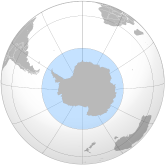
The Southern Ocean comprises the southernmost waters of the World Ocean
World Ocean
The World Ocean, world ocean, or global ocean, is the interconnected system of the Earth's oceanic waters, and comprises the bulk of the hydrosphere, covering almost 71% of the Earth's surface, with a total volume of 1.332 billion cubic kilometres.The unity and continuity of the World Ocean, with...
, generally taken to be south of 60°S latitude
60th parallel south
The 60th parallel south is a circle of latitude that is 60 degrees south of the Earth's equatorial plane. No land lies on the parallel—it crosses nothing but ocean...
and encircling Antarctica. It is usually regarded as the fourth-largest of the five principal oceanic divisions. This ocean zone is where cold, northward flowing waters from the Antarctic mix with warmer sub-Antarctic waters.
Geographers disagree on the Southern Ocean's northern boundary or even its existence, with many considering the waters part of the Pacific
Pacific Ocean
The Pacific Ocean is the largest of the Earth's oceanic divisions. It extends from the Arctic in the north to the Southern Ocean in the south, bounded by Asia and Australia in the west, and the Americas in the east.At 165.2 million square kilometres in area, this largest division of the World...
, Atlantic
Atlantic Ocean
The Atlantic Ocean is the second-largest of the world's oceanic divisions. With a total area of about , it covers approximately 20% of the Earth's surface and about 26% of its water surface area...
, and Indian Ocean
Indian Ocean
The Indian Ocean is the third largest of the world's oceanic divisions, covering approximately 20% of the water on the Earth's surface. It is bounded on the north by the Indian Subcontinent and Arabian Peninsula ; on the west by eastern Africa; on the east by Indochina, the Sunda Islands, and...
s instead. Others regard the Antarctic Convergence
Antarctic Convergence
The Antarctic Convergence is a curve continuously encircling Antarctica where cold, northward-flowing Antarctic waters meet the relatively warmer waters of the subantarctic. Antarctic waters predominantly sink beneath subantarctic waters, while associated zones of mixing and upwelling create a zone...
, an ocean zone which fluctuates seasonally, as separating the Southern Ocean from other oceans, rather than the 60th parallel. Australia
Australia
Australia , officially the Commonwealth of Australia, is a country in the Southern Hemisphere comprising the mainland of the Australian continent, the island of Tasmania, and numerous smaller islands in the Indian and Pacific Oceans. It is the world's sixth-largest country by total area...
n authorities regard the Southern Ocean as lying immediately south of Australia.
The International Hydrographic Organization
International Hydrographic Organization
The International Hydrographic Organization is the inter-governmental organisation representing the hydrographic community. It enjoys observer status at the UN and is the recognised competent authority on hydrographic surveying and nautical charting...
(IHO) has not yet ratified its 2000 definition of the ocean as being south of 60°S
60th parallel south
The 60th parallel south is a circle of latitude that is 60 degrees south of the Earth's equatorial plane. No land lies on the parallel—it crosses nothing but ocean...
. Its latest published definition of oceans dates from 1953; this does not include the Southern Ocean. However, the more recent definition is used by the IHO and others.
Geography
The Southern Ocean includes the Antarctic Circumpolar CurrentAntarctic Circumpolar Current
The Antarctic Circumpolar Current is an ocean current that flows from west to east around Antarctica. An alternative name for the ACC is the West Wind Drift. The ACC is the dominant circulation feature of the Southern Ocean and, at approximately 125 Sverdrups, the largest ocean current...
(which circulates around Antarctica) and parts of the Drake Passage
Drake Passage
The Drake Passage or Mar de Hoces—Sea of Hoces—is the body of water between the southern tip of South America at Cape Horn, Chile and the South Shetland Islands of Antarctica...
, a part of the Scotia Sea
Scotia Sea
The Scotia Sea is partly in the Southern Ocean and mostly in the South Atlantic Ocean.-Location and description:Habitually stormy and cold, the Scotia Sea is the area of water between Tierra del Fuego, South Georgia, South Sandwich Islands, South Orkney Islands and the Antarctic Peninsula, and...
, the Weddell Sea
Weddell Sea
The Weddell Sea is part of the Southern Ocean and contains the Weddell Gyre. Its land boundaries are defined by the bay formed from the coasts of Coats Land and the Antarctic Peninsula. The easternmost point is Cape Norvegia at Princess Martha Coast, Queen Maud Land. To the east of Cape Norvegia is...
, the King Haakon VII Sea
King Haakon VII Sea
King Haakon VII Sea is an arm of the Southern Ocean on the coast of East Antarctica.-Geography:From the international point of view, King Haakon VII Sea lies between Weddell Sea and Lazarev Sea, and thus stretches only along Kronprinsesse Märtha Kyst from Cape Norvegia at 12°18'W, the easternmost...
, the Cosmonaut Sea, the Cooperation Sea
Cooperation Sea
Cooperation Sea, also called Commonwealth Sea or Sodruzhestva Sea, is a sea of the Southern Ocean, between Enderby Land and West Ice Shelf , off the coast of MacRobertson Land and Princess Elizabeth Land...
,
the Davis Sea
Davis Sea
Davis Sea is an area of the sea along the coast of East Antarctica between West Ice Shelf in the west and the Shackleton Ice Shelf in the east, or between 82° and 96°E. East of it is Mawson Sea, and in the west is Cooperation Sea....
, the Mawson Sea
Mawson Sea
Mawson Sea is an area of the sea along the Queen Mary Land coast of East Antarctica between the Shackleton Ice Shelf in the west and Vincennes Bay in the east. West of it, on the western side of Shackleton Ice Shelf, is the Davis Sea. To the east is Bowman Island and Vincennes Bay.Two important...
, the D'Urville Sea
D'Urville Sea
D'Urville Sea is a sea of the Southern Ocean, north of the coast of Adélie Land, East Antarctica. It is named after the French explorer and officer Jules Dumont d'Urville....
, the Ross Sea
Ross Sea
The Ross Sea is a deep bay of the Southern Ocean in Antarctica between Victoria Land and Marie Byrd Land.-Description:The Ross Sea was discovered by James Ross in 1841. In the west of the Ross Sea is Ross Island with the Mt. Erebus volcano, in the east Roosevelt Island. The southern part is covered...
, the Amundsen Sea
Amundsen Sea
The Amundsen Sea is an arm of the Southern Ocean off Marie Byrd Land in western Antarctica. It is bounded by Cape Flying Fish, the northwestern tip of Thurston Island to the east and Cape Dart on Siple Island to the west. East of Cape Flying Fish starts the Bellingshausen Sea. West of Cape Dart is...
, and the Bellingshausen Sea
Bellingshausen Sea
The Bellingshausen Sea is an area along the west side of the Antarctic Peninsula, west of Alexander Island, east of Cape Flying Fish on Thurston Island, and south of Peter I Island . In the south are, from west to east, Eights Coast, Bryan Coast and English Coast of West Antarctica...
(in clockwise order).
The Southern Ocean differs from the other oceans in that its largest boundary, the northern boundary, does not abut a landmass, but merges into the Atlantic, Indian and Pacific Oceans. This calls into question why geographers should consider the Southern Ocean a separate ocean, as opposed to a southward extension of the other three oceans. One reason stems from the fact that much of the water of the Southern Ocean differs from the water in the other oceans. Because of the Antarctic Circumpolar Current
Antarctic Circumpolar Current
The Antarctic Circumpolar Current is an ocean current that flows from west to east around Antarctica. An alternative name for the ACC is the West Wind Drift. The ACC is the dominant circulation feature of the Southern Ocean and, at approximately 125 Sverdrups, the largest ocean current...
, that water gets transported around the Southern Ocean fairly rapidly, so that the water in the Southern Ocean south of, for example, New Zealand, resembles the water in the Southern Ocean south of South America more closely than it resembles the water in the Pacific Ocean.
Several processes operate along the coast of Antarctica to produce, in the Southern Ocean, types of water mass
Water mass
An oceanographic water mass is an identifiable body of water with a common formation history which has physical properties distinct from surrounding water...
es not produced elsewhere in the oceans of the Southern Hemisphere. One of these is the Antarctic Bottom Water
Antarctic Bottom Water
The 'Antarctic Bottom Water' is a type of water mass in the seas surrounding Antarctica with temperatures ranging from 0 to -0.8◦ C, salinities from 34.6 to 34.7 psu, and a density near 27.88...
, a very cold, highly saline, dense water that forms under sea ice
Sea ice
Sea ice is largely formed from seawater that freezes. Because the oceans consist of saltwater, this occurs below the freezing point of pure water, at about -1.8 °C ....
.
The Southern Ocean, geologically the youngest of the oceans, formed when Antarctica and South America
South America
South America is a continent situated in the Western Hemisphere, mostly in the Southern Hemisphere, with a relatively small portion in the Northern Hemisphere. The continent is also considered a subcontinent of the Americas. It is bordered on the west by the Pacific Ocean and on the north and east...
moved apart, opening the Drake Passage
Drake Passage
The Drake Passage or Mar de Hoces—Sea of Hoces—is the body of water between the southern tip of South America at Cape Horn, Chile and the South Shetland Islands of Antarctica...
, roughly 30 million years ago. The separation of the continents allowed the formation of the Antarctic Circumpolar Current.
Existence and definitions
The 1937 second edition of the International Hydrographic Organization
International Hydrographic Organization
The International Hydrographic Organization is the inter-governmental organisation representing the hydrographic community. It enjoys observer status at the UN and is the recognised competent authority on hydrographic surveying and nautical charting...
's (IHO) Limits of Oceans and Seas publication included a definition of an ocean around Antarctica. However, this ocean did not appear in the 1953 third edition because "the northern limits ... are difficult to lay down owing to their seasonal change" - instead the Atlantic, Indian and Pacific Oceans were extended southward.
The IHO readdressed the question of the ocean's existence in a survey in 2000. Of its 68 member nations, 28 responded, and all responding members except Argentina
Argentina
Argentina , officially the Argentine Republic , is the second largest country in South America by land area, after Brazil. It is constituted as a federation of 23 provinces and an autonomous city, Buenos Aires...
agreed to define a new ocean, reflecting the importance placed by oceanographers on ocean currents. The proposal for the name Southern Ocean won 18 votes, beating the alternative Antarctic Ocean. Half of the votes supported a definition of the ocean's northern limit at 60°S
60th parallel south
The 60th parallel south is a circle of latitude that is 60 degrees south of the Earth's equatorial plane. No land lies on the parallel—it crosses nothing but ocean...
(with no land interruptions at this latitude), with the other 14 votes cast for other definitions, mostly 50°S
50th parallel south
The 50th parallel south is a circle of latitude that is 50 degrees south of the Earth's equatorial plane. It crosses the Atlantic Ocean, the Indian Ocean, the Pacific Ocean and South America....
, but a few for as far north as 35°S
35th parallel south
The 35th parallel south is a circle of latitude that is 35 degrees south of the Earth's equatorial plane. It crosses the Atlantic Ocean, the Indian Ocean, Australasia, the Pacific Ocean and South America....
. However, the 4th edition of Limits of Oceans and Seas was never ratified or published due to a reservation lodged by Australia, and so the 3rd edition (which does not delineate a separate Southern Ocean) has not been superseded. If and when the 4th edition is published, it will restore the Southern Ocean as originally outlined in the 2nd edition and subsequently omitted from the 3rd.
Despite this, the 4th edition definition has de facto usage by many organisations, scientists and nations - even by the IHO. Some nations' hydrographic offices have defined their own boundaries; the United Kingdom used the 55°S parallel
55th parallel south
The 55th parallel south is a circle of latitude that is 55 degrees south of the Earth's equatorial plane. It crosses the Atlantic Ocean, the Indian Ocean, the Pacific Ocean and South America....
for example.
Other sources such as the National Geographic Society
National Geographic Society
The National Geographic Society , headquartered in Washington, D.C. in the United States, is one of the largest non-profit scientific and educational institutions in the world. Its interests include geography, archaeology and natural science, the promotion of environmental and historical...
continue to show the Atlantic
Atlantic Ocean
The Atlantic Ocean is the second-largest of the world's oceanic divisions. With a total area of about , it covers approximately 20% of the Earth's surface and about 26% of its water surface area...
, Pacific
Pacific Ocean
The Pacific Ocean is the largest of the Earth's oceanic divisions. It extends from the Arctic in the north to the Southern Ocean in the south, bounded by Asia and Australia in the west, and the Americas in the east.At 165.2 million square kilometres in area, this largest division of the World...
and Indian
Indian Ocean
The Indian Ocean is the third largest of the world's oceanic divisions, covering approximately 20% of the water on the Earth's surface. It is bounded on the north by the Indian Subcontinent and Arabian Peninsula ; on the west by eastern Africa; on the east by Indochina, the Sunda Islands, and...
Oceans as extending to Antarctica, although articles on the National Geographic web site have begun to reference the Southern Ocean.
In Australia
Australia
Australia , officially the Commonwealth of Australia, is a country in the Southern Hemisphere comprising the mainland of the Australian continent, the island of Tasmania, and numerous smaller islands in the Indian and Pacific Oceans. It is the world's sixth-largest country by total area...
, cartographical authorities defined the Southern Ocean as including the entire body of water between Antarctica and the south coasts of Australia and New Zealand
New Zealand
New Zealand is an island country in the south-western Pacific Ocean comprising two main landmasses and numerous smaller islands. The country is situated some east of Australia across the Tasman Sea, and roughly south of the Pacific island nations of New Caledonia, Fiji, and Tonga...
, although New Zealand authorities do not generally follow suit. Coastal maps of Tasmania
Tasmania
Tasmania is an Australian island and state. It is south of the continent, separated by Bass Strait. The state includes the island of Tasmania—the 26th largest island in the world—and the surrounding islands. The state has a population of 507,626 , of whom almost half reside in the greater Hobart...
and South Australia
South Australia
South Australia is a state of Australia in the southern central part of the country. It covers some of the most arid parts of the continent; with a total land area of , it is the fourth largest of Australia's six states and two territories.South Australia shares borders with all of the mainland...
label the sea areas as Southern Ocean, while Cape Leeuwin
Cape Leeuwin
Cape Leeuwin is the most south-westerly mainland point of the Australian Continent, in the state of Western Australia.A few small islands and rocks, the St Alouarn Islands, extend further to the south. The nearest settlement, north of the cape, is Augusta. South-east of Cape Leeuwin, the coast...
in Western Australia
Western Australia
Western Australia is a state of Australia, occupying the entire western third of the Australian continent. It is bounded by the Indian Ocean to the north and west, the Great Australian Bight and Indian Ocean to the south, the Northern Territory to the north-east and South Australia to the south-east...
is described as the point where the Indian and Southern Oceans meet.
Features
The Southern Ocean lies in the Southern Hemisphere. It has typical depths of between 4,000 and 5,000 meters (13,000 to 16,000 ft) over most of its extent with only limited areas of shallow water. The Antarctic continental shelfAntarctic continental shelf
The Antarctic continental shelf is a geological feature that underlies the Southern Ocean, surrounding the continent of Antarctica. The shelf is generally narrow and unusually deep, its edge lying at depths of 400 to 800 meters . It is home to a thriving ecosystem of penguins and cold-water fish....
appears generally narrow and unusually deep, its edge lying at depths up to 800 meters (2,600 ft), compared to a global mean of 133 meters (436 ft).
Equinox
Equinox
An equinox occurs twice a year, when the tilt of the Earth's axis is inclined neither away from nor towards the Sun, the center of the Sun being in the same plane as the Earth's equator...
to equinox in line with the sun's seasonal influence, the Antarctic ice pack fluctuates from an average minimum of 2.6 million square kilometers in March to about 18.8 million square kilometers in September, more than a sevenfold increase in area.
The Antarctic Circumpolar Current moves perpetually eastward — chasing and joining itself, and at 21,000 kilometers (13,000 mi) in length — it comprises the world's longest ocean current, transporting 130 million cubic meters of water per second — 100 times the flow of all the world's rivers.
The Southern Ocean's greatest depth of 7,236 meters (23,737 ft) occurs at the southern end of the South Sandwich Trench
South Sandwich Trench
The South Sandwich Trench is a deep arcuate trench in the South Atlantic Ocean lying 100 km to the east of the South Sandwich Islands. The trench is produced by the subduction of the southernmost portion of the South American Plate beneath the small South Sandwich Plate. The South Sandwich...
, at 60°00'S, 024°W.
Climate
Sea temperatures vary from about −2 to 10 °CCelsius
Celsius is a scale and unit of measurement for temperature. It is named after the Swedish astronomer Anders Celsius , who developed a similar temperature scale two years before his death...
(28 to 50 °F
Fahrenheit
Fahrenheit is the temperature scale proposed in 1724 by, and named after, the German physicist Daniel Gabriel Fahrenheit . Within this scale, the freezing of water into ice is defined at 32 degrees, while the boiling point of water is defined to be 212 degrees...
). Cyclonic storms travel eastward around the continent and frequently become intense because of the temperature contrast between ice and open ocean. The ocean-area from about latitude 40 south
40th parallel south
The 40th parallel south is a circle of latitude that is 40 degrees south of the Earth's equatorial plane. It crosses the Atlantic Ocean, the Indian Ocean, Australasia, the Pacific Ocean and South America....
to the Antarctic Circle has the strongest average winds found anywhere on Earth. In winter the ocean freezes outward to 65 degrees south latitude
65th parallel south
The 65th parallel south is a circle of latitude that is 65 degrees south of the Earth's equatorial plane. It crosses the Southern Ocean and Antarctica.Starting at the Prime Meridian and heading eastwards, the parallel 65° south passes through:-See also:...
in the Pacific sector and 55 degrees south latitude
55th parallel south
The 55th parallel south is a circle of latitude that is 55 degrees south of the Earth's equatorial plane. It crosses the Atlantic Ocean, the Indian Ocean, the Pacific Ocean and South America....
in the Atlantic sector, lowering surface temperatures well below 0 degrees Celsius. At some coastal points, however, persistent intense drainage winds from the interior keep the shoreline ice-free throughout the winter.
Natural resources
- Probable large and possible giant oilPetroleumPetroleum or crude oil is a naturally occurring, flammable liquid consisting of a complex mixture of hydrocarbons of various molecular weights and other liquid organic compounds, that are found in geologic formations beneath the Earth's surface. Petroleum is recovered mostly through oil drilling...
and gasNatural gasNatural gas is a naturally occurring gas mixture consisting primarily of methane, typically with 0–20% higher hydrocarbons . It is found associated with other hydrocarbon fuel, in coal beds, as methane clathrates, and is an important fuel source and a major feedstock for fertilizers.Most natural...
fields on the continental marginContinental marginThe continental margin is the zone of the ocean floor that separates the thin oceanic crust from thick continental crust. Continental margins constitute about 28% of the oceanic area.... - Manganese nodules
- Possible placer depositPlacer depositIn geology, a placer deposit or placer is an accumulation of valuable minerals formed by gravity separation during sedimentary processes. The name is from the Spanish word placer, meaning "alluvial sand". Placer mining is an important source of gold, and was the main technique used in the early...
s - Sand and gravel
- Fresh water (in the form of icebergsIcebergAn iceberg is a large piece of ice from freshwater that has broken off from a snow-formed glacier or ice shelf and is floating in open water. It may subsequently become frozen into pack ice...
)
- Fauna:
- squidSquidSquid are cephalopods of the order Teuthida, which comprises around 300 species. Like all other cephalopods, squid have a distinct head, bilateral symmetry, a mantle, and arms. Squid, like cuttlefish, have eight arms arranged in pairs and two, usually longer, tentacles...
- whaleWhaleWhale is the common name for various marine mammals of the order Cetacea. The term whale sometimes refers to all cetaceans, but more often it excludes dolphins and porpoises, which belong to suborder Odontoceti . This suborder also includes the sperm whale, killer whale, pilot whale, and beluga...
s - seals
- krillKrillKrill is the common name given to the order Euphausiacea of shrimp-like marine crustaceans. Also known as euphausiids, these small invertebrates are found in all oceans of the world...
- various fishFishFish are a paraphyletic group of organisms that consist of all gill-bearing aquatic vertebrate animals that lack limbs with digits. Included in this definition are the living hagfish, lampreys, and cartilaginous and bony fish, as well as various extinct related groups...
- 17 species of penguins
- squid
Natural hazards
IcebergsIceberg
An iceberg is a large piece of ice from freshwater that has broken off from a snow-formed glacier or ice shelf and is floating in open water. It may subsequently become frozen into pack ice...
can occur at any time of year throughout the ocean. Some may have drafts up to several hundred meters; smaller icebergs, iceberg fragments and sea-ice (generally 0.5 to 1 meter thick) also pose problems for ships. The deep continental shelf has a floor of glacial deposits varying widely over short distances.
Sailors know latitudes from 40
40th parallel south
The 40th parallel south is a circle of latitude that is 40 degrees south of the Earth's equatorial plane. It crosses the Atlantic Ocean, the Indian Ocean, Australasia, the Pacific Ocean and South America....
to 70 degrees south
70th parallel south
The 70th parallel south is a circle of latitude that is 70 degrees south of the Earth's equatorial plane in the Antarctic. The parallel passes through the Southern Ocean and Antarctica.Mariners regard the waters in the 70° south as "Godless"....
as the "Roaring Forties
Roaring Forties
The Roaring Forties is the name given to strong westerly winds found in the Southern Hemisphere, generally between the latitudes of 40 and 49 degrees. Air displaced from the Equator towards the South Pole, which travels close to the surface between the latitudes of 30 and 60 degrees south, combines...
", "Furious Fifties" and "Shrieking Sixties" due to high winds and large waves that form as winds blow around the entire globe unimpeded by any land-mass. Ship ice, especially in May to October, makes the area even more dangerous. The remoteness of the region makes sources of search and rescue scarce.
Current issues
Increased solar ultraviolet radiationUltraviolet
Ultraviolet light is electromagnetic radiation with a wavelength shorter than that of visible light, but longer than X-rays, in the range 10 nm to 400 nm, and energies from 3 eV to 124 eV...
resulting from the Antarctic ozone hole has reduced marine primary productivity (phytoplankton
Phytoplankton
Phytoplankton are the autotrophic component of the plankton community. The name comes from the Greek words φυτόν , meaning "plant", and πλαγκτός , meaning "wanderer" or "drifter". Most phytoplankton are too small to be individually seen with the unaided eye...
) by as much as 15% and has started damaging the DNA
DNA
Deoxyribonucleic acid is a nucleic acid that contains the genetic instructions used in the development and functioning of all known living organisms . The DNA segments that carry this genetic information are called genes, but other DNA sequences have structural purposes, or are involved in...
of some fish. Illegal, unreported, and unregulated fishing, especially the landing of an estimated five to six times more Patagonian toothfish
Patagonian toothfish
The Patagonian toothfish, Dissostichus eleginoides , is a fish found in the cold, temperate waters of the southern Atlantic, southern Pacific, Indian, and Southern Oceans on seamounts and continental shelves around most sub-Antarctic islands.A close relative, the Antarctic toothfish , is found...
than the regulated fishery, likely affects the sustainability of the stock. Long-line fishing for toothfish causes a high incidence of seabird mortality.
International agreements
All international agreements regarding the world's oceans apply to the Southern Ocean. In addition, it is subject to these agreements specific to the region:- International Whaling CommissionInternational Whaling CommissionThe International Whaling Commission is an international body set up by the terms of the International Convention for the Regulation of Whaling , which was signed in Washington, D.C...
, which prohibits commercial whalingWhalingWhaling is the hunting of whales mainly for meat and oil. Its earliest forms date to at least 3000 BC. Various coastal communities have long histories of sustenance whaling and harvesting beached whales...
south of 40 degrees south40th parallel southThe 40th parallel south is a circle of latitude that is 40 degrees south of the Earth's equatorial plane. It crosses the Atlantic Ocean, the Indian Ocean, Australasia, the Pacific Ocean and South America....
(south of 60 degrees south60th parallel southThe 60th parallel south is a circle of latitude that is 60 degrees south of the Earth's equatorial plane. No land lies on the parallel—it crosses nothing but ocean...
between 50 degrees50th meridian westThe meridian 50° west of Greenwich is a line of longitude that extends from the North Pole across the Arctic Ocean, Greenland, the Atlantic Ocean, South America, the Southern Ocean, and Antarctica to the South Pole....
and 130 degrees west130th meridian westThe meridian 130° west of Greenwich is a line of longitude that extends from the North Pole across the Arctic Ocean, North America, the Pacific Ocean, the Southern Ocean, and Antarctica to the South Pole....
). JapanJapanJapan is an island nation in East Asia. Located in the Pacific Ocean, it lies to the east of the Sea of Japan, China, North Korea, South Korea and Russia, stretching from the Sea of Okhotsk in the north to the East China Sea and Taiwan in the south...
regularly does not recognize this provision, because the sanctuary violates IWC charter. Since the scope of the sanctuary is limited to commercial whaling, in regard to its whaling permit and whaling for scientific research, a Japanese fleet carries out an annual whale-hunt in the region. See Southern Ocean Whale SanctuarySouthern Ocean Whale SanctuaryThe Southern Ocean Whale Sanctuary is an area of 50 million square kilometres surrounding the continent of Antarctica where the International Whaling Commission has banned all types of commercial whaling...
. - Convention for the Conservation of Antarctic SealsConvention for the Conservation of Antarctic SealsThe Convention for the Conservation of Antarctic Seals is part of the Antarctic Treaty System. It was signed at the conclusion of a multilateral conference in London on February 11, 1972...
has limited seal-hunting. - Convention on the Conservation of Antarctic Marine Living Resources regulates fishing in the region.
Many nations prohibit the exploration for and the exploitation of mineral
Mineral
A mineral is a naturally occurring solid chemical substance formed through biogeochemical processes, having characteristic chemical composition, highly ordered atomic structure, and specific physical properties. By comparison, a rock is an aggregate of minerals and/or mineraloids and does not...
resources south of the fluctuating polar front
Polar front
In meteorology, the polar front is the boundary between the polar cell and the Ferrel cell in each hemisphere. At this boundary a sharp gradient in temperature occurs between these two air masses, each at very different temperatures....
, which lies in the middle of the Antarctic Circumpolar Current and serves as the dividing line between the very cold polar surface waters to the south and the warmer waters to the north. The Antarctic Treaty covers the portion of the globe south of sixty degrees south
60th parallel south
The 60th parallel south is a circle of latitude that is 60 degrees south of the Earth's equatorial plane. No land lies on the parallel—it crosses nothing but ocean...
,
it prohibits new claims to Antarctica and to all islands in the Southern Ocean.
Economy
Between 1 July 1998 and 30 June 1999 fisheries landed 119,898 tonneTonne
The tonne, known as the metric ton in the US , often put pleonastically as "metric tonne" to avoid confusion with ton, is a metric system unit of mass equal to 1000 kilograms. The tonne is not an International System of Units unit, but is accepted for use with the SI...
s, of which 85% consisted of krill
Krill
Krill is the common name given to the order Euphausiacea of shrimp-like marine crustaceans. Also known as euphausiids, these small invertebrates are found in all oceans of the world...
and 14% of Patagonian toothfish
Patagonian toothfish
The Patagonian toothfish, Dissostichus eleginoides , is a fish found in the cold, temperate waters of the southern Atlantic, southern Pacific, Indian, and Southern Oceans on seamounts and continental shelves around most sub-Antarctic islands.A close relative, the Antarctic toothfish , is found...
. International agreements came into force in late 1999 to reduce illegal, unreported, and unregulated fishing, which in the 1998-99 season landed five to six times more Patagonian toothfish than the regulated fishery.
Ports and harbors
Rothera Research Station
Rothera research station is a British Antarctic Survey base on the Antarctic Peninsula, located at Rothera Point, Adelaide Island. Rothera also serves as the capital of the British Overseas Territory, the British Antarctic Territory....
, Palmer Station
Palmer Station
Palmer Station, on Anvers Island, is Antarctica's only US station north of the Antarctic Circle. Initial construction of the station finished in 1968. The station, like the other US Antarctic stations, is operated by the United States Antarctic Program....
, Villa Las Estrellas
Villa Las Estrellas
Villa Las Estrellas is a Chilean town in Antártica Commune, Antártica Province, Magallanes and Antártica Chilena Region. It is located on President Eduardo Frei Montalva Base, a military base, on King George Island. It is the biggest and one of only two civilian settlements on Antarctica...
, Esperanza Base
Esperanza Base
-References:*Antarctica. Sydney: Reader's Digest, 1985, p. 156-157.*Child, Jack. Antarctica and South American Geopolitics: Frozen Lebensraum. New York: Praeger Publishers, 1988, p. 73....
, Mawson Station
Mawson Station
Mawson Station is one of three permanent Australian bases in the Australian Antarctic Territory of East Antarctica. Named after Antarctic explorer Sir Douglas Mawson, the base is managed by the Australian Antarctic Division...
, McMurdo Station
McMurdo Station
McMurdo Station is a U.S. Antarctic research center located on the southern tip of Ross Island, which is in the New Zealand-claimed Ross Dependency on the shore of McMurdo Sound in Antarctica. It is operated by the United States through the United States Antarctic Program, a branch of the National...
, and offshore anchorages in Antarctica.
Few ports or harbors exist on the southern (Antarctic) coast of the Southern Ocean, since ice conditions limit use of most shores to short periods in midsummer; even then some require icebreaker
Icebreaker
An icebreaker is a special-purpose ship or boat designed to move and navigate through ice-covered waters. Although the term usually refers to ice-breaking ships, it may also refer to smaller vessels .For a ship to be considered an icebreaker, it requires three traits most...
escort for access. Most Antarctic ports are operated by government research stations and, except in an emergency, remain closed to commercial or private vessels; vessels in any port south of 60 degrees south
60th parallel south
The 60th parallel south is a circle of latitude that is 60 degrees south of the Earth's equatorial plane. No land lies on the parallel—it crosses nothing but ocean...
are subject to inspection by Antarctic Treaty observers.
The Southern Ocean's southernmost port operates at McMurdo Station at 77°50′S 166°40′E. Winter Quarters Bay
Winter Quarters Bay
Winter Quarters Bay is a small cove of McMurdo Sound, Antarctica, located 2,200 miles due south of New Zealand at 77°50'S. The harbor is the southern-most port in the Southern Ocean and features a floating ice pier for summer cargo operations. The bay is approximately 250m wide and long, with a...
forms a small harbor, on the southern tip of Ross Island
Ross Island
Ross Island is an island formed by four volcanoes in the Ross Sea near the continent of Antarctica, off the coast of Victoria Land in McMurdo Sound.-Geography:...
where a floating Ice pier
Ice pier
An ice pier is a man-made structure used to assist the unloading of ships in Antarctica. It is constructed by pumping seawater into a contained area and allowing the water to freeze. By repeating this procedure several times, additional layers are built up. The final structure is many metres in...
makes port operations possible in summer. Operation Deep Freeze
Operation Deep Freeze
Operation Deep Freeze is the codename for a series of United States missions to Antarctica, beginning with "Operation Deep Freeze I" in 1955–56, followed by "Operation Deep Freeze II", "Operation Deep Freeze III", and so on...
personnel constructed the first ice pier at McMurdo in 1973.
See also
- AntarcticAntarcticThe Antarctic is the region around the Earth's South Pole, opposite the Arctic region around the North Pole. The Antarctic comprises the continent of Antarctica and the ice shelves, waters and island territories in the Southern Ocean situated south of the Antarctic Convergence...
- Ernest ShackletonErnest ShackletonSir Ernest Henry Shackleton, CVO, OBE was a notable explorer from County Kildare, Ireland, who was one of the principal figures of the period known as the Heroic Age of Antarctic Exploration...
(explorer) - Extreme points of the AntarcticExtreme points of the AntarcticThis is a list of the extreme points of the Antarctic, the points of Antarctic and sub-Antarctic lands that are farther to the south than any other location classified by continent and country...
- Roaring fortiesRoaring FortiesThe Roaring Forties is the name given to strong westerly winds found in the Southern Hemisphere, generally between the latitudes of 40 and 49 degrees. Air displaced from the Equator towards the South Pole, which travels close to the surface between the latitudes of 30 and 60 degrees south, combines...
- Seven seasSeven SeasThe phrase "Seven Seas" can refer either to a particular set of seven seas or to a great expanse of water in general. Today in modern times, this also includes the four oceans, and three large seas...
- SubantarcticSubantarcticThe Subantarctic is a region in the southern hemisphere, located immediately north of the Antarctic region. This translates roughly to a latitude of between 46° – 60° south of the Equator. The subantarctic region includes many islands in the southern parts of the Indian Ocean, Atlantic Ocean and...
- Borders of the oceansBorders of the oceansThe borders of the oceans are the limits of the several oceans of the Earth. The definition, as well as the number of oceans can vary depending on the adopted criteria.-Overview:...
Further reading
- Gille, Sarah T. 2002. "Warming of the Southern Ocean since the 1950s": abstract, article. ScienceScience (journal)Science is the academic journal of the American Association for the Advancement of Science and is one of the world's top scientific journals....
: vol. 295 (no. 5558), pp. 1275–1277. - Descriptive Regional Oceanography, P. Tchernia, Pergamon Press, 1980.
- Matthias Tomczak and J. Stuart Godfrey. 2003. Regional Oceanography: an Introduction. (see the site)
External links
- Oceanography Image of the Day, from the Woods Hole Oceanographic Institution
- The CIA World Factbook's entry on the Southern Ocean
- The Fifth Ocean from Geography.About.com
- NOAA In-situ Ocean Data Viewer Plot and download ocean observations
- NOAA FAQ about the number of oceans