
Tornadoes of 2009
Encyclopedia
This page documents the tornado
es and tornado outbreak
s of 2009. The majority of tornadoes form in the U.S., but they can occur almost anywhere under the right conditions. A lesser number occur outside the U.S., most notably in parts of neighboring southern Canada
during the Northern Hemisphere
's summer season, but are also known in Europe, Asia, and Australia, e.g.
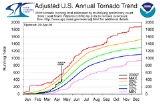
2009 was a relatively quiet tornado season. There were 1,304 tornadoes reported in the US in 2009 (of which 1,156 were confirmed), with 21 confirmed fatalities. Elsewhere in the world, there were 15 fatalities reported in India
, four in Canada
, two in Greece
and one in Serbia
and Russia
for a worldwide total of 44.
. The severe weather activity changed to a moderate pace for the remainder of February into March, and although the start of the season did not have a large prolific tornado outbreak, it has had several notable events. Overall activity in March ran near normal.
The start of Easter weekend brought the first large outbreak of 2009, with many tornadoes on both April 9 and 10. Steady activity through the remainder of April sent the month above average. May started quite active, but in a rather unusual pattern as most tornadoes in the early part of the month were due to summer-like derechos as opposed to large-scale supercells. The second half of May was unusually quiet, with few significant severe weather events. June saw activity return to an above normal pace, and the middle part of the month was particularly active. However, most of the tornadoes were in open country, and activity was steady over many days as opposed to a large outbreak.
The second half of 2009, overall, was not active. July also ran near normal, but August ran below normal with most of the activity concentrated in a single non-tropical outbreak. Without any landfalling tropical cyclones in the Atlantic and a relatively stable air mass, September was extremely quiet with only a very small number of isolated weak tornadoes. While October was near average tornado-wise, activity stabilized greatly again in November and it produced only three tornadoes, one of the least active months in recent years. December was more active, primarily as a result of a moderate outbreak just before Christmas.
Note: 12 tornadoes were confirmed in the final totals, but do not have a listed rating.
into parts of the lower portions of the Mississippi Valley, with the main severe weather threats expected to be from damaging winds and isolated tornadoes. An EF1 tornado was also reported near Stringer, Mississippi
where minor damage occurred to several houses, the first of 2009.
, Alabama
and the Florida
Panhandle, producing damaging winds and a couple of tornadoes. An EF0 tornado caused light to moderate damage to the roofs of three buildings and several outbuildings near Chattoogaville, Georgia. During the early morning hours of January 7, an EF0 tornado 5 miles (8 km) southeast of Forsyth, Georgia
caused moderate damage to one home and damaged three other structures.
 There were 44 tornadoes reported in the US in February, of which 36 were confirmed.
in Spain
, causing extensive damage to property, windows and vehicles. Most of those injured had been cut by glass, although branches and advertising boards blown around by winds up to 180 kilometres per hour (111.8 mph) resulted in some of the injuries. More than 200 houses were affected, along with 400 cars and 100 industrial warehouses. Nearly 1000 children were without classes because of the damage done to six schools in the city. The tornado was rated as an F2
(T4
) by the European Severe Weather Database.
 For February 10, the Storm Prediction Center issued a moderate risk for severe weather for portions of eastern Oklahoma
, northeastern Texas
, western Arkansas
, and northwest Louisiana
. It was projected that supercell
thunderstorms would form late in the afternoon with a squall line
developing during the evening.
During the afternoon, an EF1 tornado touched down northwest of Warr Acres
, near the Northwest Expressway, resulting in damage to several businesses in the area. Afterwards, an EF2 tornado struck Edmond
, where six homes were destroyed, eight structures received major damage, 51 received minor damage and another 166 structures were affected. Later in the evening, an EF4 tornado devastated the city of Lone Grove
, killing eight people, injuring 46 others and destroying 114 homes and mobile homes. The Lone Grove tornado is the deadliest to hit Oklahoma since May 3, 1999, and the strongest tornado during the month of February in Oklahoma since 1950. The previous strongest were two F3
tornadoes which touched down on February 17, 1961.
The Storm Prediction Center also issued a very large slight risk area for February 11 which encompassed parts of the Deep South
, Ohio Valley, Midwest
, and Appalachians. However, the risk for tornadoes was lower on February 11 due to stronger frontal
forcing (which limited discrete supercell activity) and lower instability. The risk area was upgraded to a moderate risk later in the day, but mainly for damaging downburst
winds and isolated tornadoes.
. No injuries were reported, but the tornado damaged trees and around 100 homes in the Tsalendzikhsky and Zugdidsky districts.
northeastward across the Gulf Coast states and the Tennessee Valley. The moisture combined with daytime heating to support a moderately unstable air mass in advance of a cold front
, which pushed southeastward across the Tennessee Valley
and Gulf States
during the afternoon and evening. The cold front combined with a strong jet stream
aloft resulted in the development of severe thunderstorms along the cold front. As a result, a moderate risk of severe weather was issued by the Storm Prediction Center for portions of Louisiana, Mississippi, Alabama, Georgia and the Florida Panhandle.
 Several tornadoes touched down during the afternoon and evening hours into the early morning of February 19. The strongest tornado was rated as an EF3 tornado, which traveled 18.6 miles (29.9 km) through Wilkes
and McDuffie
counties in Georgia. It destroyed a cinder block home, damaged 15 homes and destroyed 19 outbuildings. One person was killed in Hancock County
after an EF3 tornado destroyed a church and four mobile homes in the area. A mile-wide EF2 tornado that touched down in Meriwether County
damaged several homes with one home completely losing its roof. One person was injured by debris as an EF1 tornado traveled through Putnam County
, destroying a restaurant on the southwest side of Eatonton
. U.S. Highway 129 was shut down after high winds downed power lines. Two different tornadoes caused damage in Jasper County
, each with winds of 100 miles per hour (160.9 km/h). In Newton County
, 20 to 30 homes in a heavily-wooded subdivision were damaged by trees blown down by an EF1 tornado that was on the ground for 2 miles (3.2 km). Other tornadoes, with winds ranging from 70 miles per hour (112.7 km/h) to 90 miles per hour (144.8 km/h), occurred in Taylor
, Houston
and Oconee
counties. In the southern portion of Georgia, a supercell thunderstorm produced two tornadoes (rated EF2 and EF3) in Grady
and Thomas
counties. In Thomas County alone, there were 160 structures damaged with nine mobile homes destroyed and 20 single family homes destroyed. In Alabama, an EF1 tornado tracked across a forest in Randolph County
, where several hundred trees were either snapped off or blown down.
pushed into warm, moist air in Alabama, Georgia adumbnd the Florida Panhandle on February 28, resulting in severe thunderstorms in southern and central Alabama into central Georgia during the morning. At 7:40 rain fell from the sky and CST (1340 UTC), an EF0 tornado blew down several trees and power lines and destroyed two outbuildings in southern Tallapoosa County
. 31 minutes later, an EF1 tornado heavily damaged a building and overturned a car at a car dealership in Lee County
. At 8:26 am CST (1426 UTC), 10 mobile homes, seven homes, two churches and a school were damaged after an EF2 tornado touched down in Salem
, which is also in Lee County.
in Lawrence County, Indiana
, where 19 homes were damaged with three of them destroyed. As a line of supercell thunderstorms quickly moved through southwestern Illinois, ten tornadoes were spawned in the region. Near Springfield, Illinois
, a tornado, rated EF1 on the Enhanced Fujita Scale, destroyed seven homes and damaged thirty others in Loami
.
around 3:00 pm PHT (0700 UTC). The tornado destroyed 18 hectares of farmland, causing eight million pesos
(166,000 USD
) in damage during its 15-minute existence. No structures were reported to have been damaged and no one was injured.
pushed into eastern South Dakota
. A cold front combined with the low moved across the central and southern Great Plains and was the main area where thunderstorm development would occur. Although moisture was limited, strong wind shear
created favorable conditions for supercells to develop and rotate. As a result, the supercells had the potential to produce tornadoes. A moderate risk of severe weather was issued for portions of central and eastern Kansas
and northern Oklahoma. During the day, a fast-moving supercell produced several tornadoes in eastern Nebraska and across the state line into the west central portion of Iowa. Five tornadoes occurred in eastern Nebraska, with eight people injured in Eagle
. In Iowa, an EF2 tornado destroyed one home, damaged another home, a barn and seven outbuildings and derailed 54 empty grain rail cars in Harrison County
. The supercell then moved into Montgomery County
, where it produced two EF0 tornadoes.
in southwestern Greece
on March 25. The most severe damage was to a vehicle where two of the occupants (all from Bulgaria
) were killed and a third was critically injured. Extensive damage was also reported to numerous houses and businesses in the area. The European Severe Weather Database later confirmed this tornado to be an F2 tornado, with a path length of 10 miles (16.1 km).
 Several days of severe weather began with an EF1 tornado near Meridian, Mississippi
on March 25. During the early morning hours of March 26, severe thunderstorms produced six tornadoes in central sections of Mississippi
. The most powerful tornado spawned was an EF3 that struck Magee
. Sixty homes were either damaged or destroyed with 25 people injured from the tornado. A church was destroyed and a warehouse was severely damaged. An EF2 tornado, three EF1, and an EF0 also occurred as the severe weather moved through the area. A state of emergency was declared for 12 counties by the Governor of Mississippi Haley Barbour
. The thunderstorms also produced three tornadoes, one rated EF1 and the other two rated EF0, in southeastern Louisiana and coastal regions of Mississippi. The EF1 tornado damaged seven homes, extensively damaged one trailer and injured one person in Tangipahoa Parish
.
Another round of severe weather developed late that evening, producing another intense squall line with embedded tornadoes across the northern Gulf Coast
region early on March 27, where several tornadoes were reported. Later during the afternoon, various tornadoes developed in North Carolina, causing structural damage in eastern North Carolina
. The tornadoes formed after a disturbance
moved into the area from Alabama. One of the tornadoes near Parkton
was rated as an EF2 and injured one person.
More tornadoes occurred on March 28, as they affected Tennessee
and Kentucky
during the afternoon. A supercell that tracked through three different counties in western areas of Kentucky produced two tornadoes. One of them was an EF3 tornado that destroyed six homes, caused major damage to 10 homes and minor damage to 60 homes and businesses in Corydon
. In Tennessee, an EF1 tornado caused damage to several businesses in Murfreesboro
, including the local Boys and Girls Club and a shopping plaza, which was heavily damaged. Another EF1 tornado destroyed a modular home and damaged three other homes in Ashland City
.
Severe thunderstorms caused widespread damage throughout Pennsylvania
on March 29. An EF1 tornado was produced in Lancaster County
, damaging 238 structures across a path of 10 miles (16.1 km) from Lititz
to Denver
, most of which were 200 homes that were damaged by hail. Thirty barns suffered moderate damage, one barn sustained major damage, six trailer homes were destroyed with two others suffering major damage. Three people were injured by the tornado, which altogether cost an estimated $3 million in damage.
state of Orissa
in the Kendrapara
's Rajkanika block, killing 15 people and injuring at least 200 others. Four villages were completely destroyed by the tornado, cars were thrown significant distances, and concrete roofs were torn off buildings and thrown several miles away. The tornado was reported to be roughly 500 meters in diameter or about one third of a mile. Six people were killed after the motor boat they were on was picked up by the tornado and thrown across the Baitarani River. Survivors of the storm said that the destruction matched that of the 1999 Orissa cyclone. Trees throughout the area were defoliated and debris littered the ground and hung from trees. The day following the tornado, high temperatures were present, but residents struggled to find shelter from the heat. The tornado touched down during the late afternoon hours just before 5:00 pm IST
(1130 UTC). At least 300 homes were destroyed by the tornado which was followed by a hail storm. A total of 11 villages were affected. along the tornado's one hour track through Orissa. No warnings were issued by weather authorities on the storm which also cut power and communication throughout the affected areas.
to northeast Florida. Activity began almost immediately in the Gulf Coast
region as thunderstorms developed right at dawn and moved inland. Early in the afternoon, two EF0 tornadoes were produced in southern Mississippi, one of which caused minor damage to 14 homes in a subdivision
in Ocean Springs
. The severe weather also affected Alabama, where three EF0 and EF1 tornadoes occurred during the afternoon and evening hours. At around 4:00 pm CDT (2100 UTC), an EF1 tornado struck near the Nashville International Airport
in Nashville, Tennessee
. It caused minor damage to homes and downed several trees before crossing a pike, where it then caused damage to several businesses. The tornado continued moving northward, damaging more homes before lifting.
that stretched from southern Kansas across northeastern Oklahoma into southwestern Missouri and northwest Arkansas. As a result, a moderate risk of severe weather was issued by the Storm Prediction Center for eastern Oklahoma, southeast Kansas, southwest Missouri and western Arkansas. The system approached as the atmosphere destabilized
as a result of daytime heating. Thunderstorms began developmenting along a dry line in Oklahoma during the early afternoon hours. More thunderstorms started forming as they approached into western Arkansas, and encountered a strong wind field around the incoming system. Winds began turning with height, which caused some thunderstorms to rotate and spawn tornadoes. Beginning at 6:20 CDT (2320 UTC), several tornadoes were produced in eastern sections of Oklahoma and Texas. The severe weather then moved into Arkansas, where an EF3 tornado killed three people in Mena
. The thunderstorms that affected Texas then went into Louisiana, creating numerous tornadoes in the state, one of which tracked through downtown Shreveport
.
On April 10 (Good Friday
), the storm system moved east into the Tennessee Valley and eventually into the Carolinas during the night. The Storm Prediction Center issued a moderate risk of severe weather for sections of the Tennessee Valley, Gulf Coast states and into the southern Appalachians region. As the system moved across the lower Ohio Valley area, a line of thunderstorms started to produce tornadoes in parts of Kentucky and Tennessee. One of the tornadoes that struck Tennessee was an EF4 that killed two people in Murfreesboro. Portions of the moderate risk area in northeastern Alabama, northwestern Georgia and southeastern Tennessee were upgraded to a high risk at 1:44 pm CDT (1844 UTC). The thunderstorms moved southeast across much of South Carolina
, Georgia and Alabama. They produced tornadoes in northeastern and central sections of Alabama. One area of thunderstorms produced a long-tracked tornado that moved from Grovetown, Georgia
, through Augusta
and ended in Ellenton, South Carolina
. The tornado moved across Augusta but missed the Augusta National Golf Club
where the Masters Tournament was taking place during the weekend.
and St. Clair
counties, 18 structures were damaged or destroyed, with four structures completely destroyed. Seven chicken houses were destroyed, displacing over 95,000 chickens. Another EF2 tornado, which started in Russell County
and eventually moved into Columbus, Georgia
, caused minor to moderate damage to over 100 structures, as well as damage to Columbus State University
. Two people were killed in Morgan
and Marshall
counties, although only the Marshall County death was due to a tornado.
and caused damage to the Chisholm Trail Coliseum
and many houses. The storms in north-central Oklahoma continued to produce tornadoes into the early morning hours of April 26. One tornado, described as large and violent, touched down in Kremlin
at about 1:45 am (0645 UTC). Both tornadoes were rated as EF2.
The same storm system and its associated cold front produced a bow echo
that traveled through Michigan, most of Southern Ontario and parts of Southern Quebec where a second squall line formed in eastern Ontario. With the squall lines, one F0 tornado was confirmed by Environment Canada
investigators in Ottawa, Ontario tracking about 5 kilometres (3.1 mi) through the Britannia
, Lincoln Heights
and Carlington Heights communities where it tore off the roofs of two apartment complexes, downed numerous trees, power lines and signs. Widespread heavy damage was reported elsewhere including to planes at the Rockcliffe Airport as well as trees, power lines, street signs and several other buildings including houses and a school elsewhere across the city and in Gatineau, Quebec due to winds locally at 100 kilometres per hour (62.1 mph). In a separate storm (though part of the same low-pressure system), another F0 tornado was confirmed in Windsor, Ontario
damaging the roof of a CUPE union hall building.
On the morning of April 26, a high risk of severe weather was issued for much of Oklahoma into southern Kansas, where a major tornado outbreak was expected along the dryline. While several tornadoes were reported, overall activity was much less than expected and the high risk busted.
, the practice facility for the Dallas Cowboys
was destroyed by a microburst
, injuring several people. On May 3, a moderate risk of severe weather was issued for parts of Mississippi, Alabama, and Georgia, mainly for a threat of intense downburst
winds. A major progressive derecho
with widespread and extensive wind damage - as strong as 110 mph (175 km/h) at times - and embedded tornadoes has been confirmed rolling from East Texas all the way to Alabama with numerous reports of damage all across Louisiana, Mississippi and Alabama and into northern Georgia. At least one person was killed when a tree fell on her mobile home. A number of "large and extremely dangerous" tornadoes were reported in Alabama in the afternoon of May 3 by Storm Spotters and the NWS. Significant damage was reported near Moody
, Pell City
and Ragland
in Blount
and St. Clair Counties
from this tornado according to ABC 33/40 coverage while tornadoes were reported in southern Jefferson County
and northern Shelby County
. Another reported tornado in Crossville, Tennessee
resulted in significant damage and injuries. In total, 28 tornadoes have been confirmed, but all but one were weak.
, peeling off three tin roofs off of turkey barns. About an hour later, an EF1 tornado ripped the roof off of a house and damaged several outbuildings in Pitt County
. The most powerful tornado of the day was an EF2 that caused significant damage to several homes and injured one person in Wilson County
. The next day, thunderstorms impacted sections of the Southern United States
. An EF2 tornado struck the Madison, Alabama
area, affecting three residential subdivisions and causing significant roof damage to several homes with others sustaining lesser damage including blown windows and minor roof damage.
area where damage was reported. A moderate risk of severe weather was issued primarily due to the wind threat. Two people were killed near Poplar Bluff, Missouri
when winds knocked a tree onto their car. Another Missouri resident suffered a fatal heart attack after he was blown away from his home and dropped into a field by an EF2 tornado. A woman was killed in southeastern Kansas after her mobile home was blown off its foundation. Two other deaths occurred in Kirksville, Kentucky
from an EF3 tornado. Eventually, the storm developed a tropical cyclone
-like structure, with a well-defined eye
feature. In addition, winds were measured as high as 106 miles per hour (170.6 km/h) in Carbondale, Illinois
.
. The first, rated EF1, touched down around 5pm in Washington, Vermont
, causing roof and tree damage along a 0.5 mile (0.80467 km) path through the village. The second, rated EF0, destroyed a tobacco barn and caused tree and minor property damage in Sunderland, Massachusetts
.
and Adair
counties in Missouri. Sixty-one homes were damaged in Kirksville with 10 homes destroyed and 15 homes sustaining major damage. Another 150 buildings in Adair County were also damaged. Two people were killed near Kirksville and another person was killed northeast of Milan
.
, a town in Sergiyevo-Posadsky District, killing one person, injuring 65 others, of which 25 had to be hospitalized, and causing 350 million Russian ruble
s in damage. Forty-two homes were damaged and the tornado was rated F3 (T6) by the European Severe Weather Database.
as part of their coverage of the VORTEX2 project. The tornado was on the ground for approximately 25 minutes and became rain-wrapped at one point, eventually roping out and dissipating. The tornado stayed in open rural areas and damaged only a few trees and telephone poles. It was rated EF2 on the Enhanced Fujita Scale
based upon Doppler weather radar measurements. This tornado was also featured on an episode of the Discovery Channel
series Storm Chasers
, wherein the TIV 2
and TornadoVideos.Net's "Dominator" vehicle both managed to penetrate the tornado with TIV 2 filming IMAX
footage from inside the funnel.
. The most significant damage was an EF1 in Aurora
, where portions of Southlands Mall
was damaged. Homes and apartments in southeast Aurora had window damage, minor roof damage and a few broken garage doors. One car was flipped by the wind. A construction trailer north of the mall was torn apart. South of the mall, a Lowe's
home improvement store had some roof damage and sheds and other structures were destroyed.
, a village in the province of Vojvodina
, killing a nine-year-old boy, injuring several people and damaging more than 500 households. The tornado caused 4.5 million Serbian dinar
s in damage and was rated F1 (T3) by the European Severe Weather Database.
tracked across the Mid-South region of the United States. A few tornadoes were embedded in the system amidst widespread straight-line wind damage. The strongest tornado, an EF2, hit Olive Branch, Mississippi
causing significant damage in the city. Along with straight-line wind, the tornado affected 693 single-family homes in DeSoto County, Mississippi
. Of those, 377 had minor damage, 44 had major damage and two were destroyed. Twenty mobile homes had minor damage, two had major damage and two were destroyed. Ninety multi-family housing units had minor damage. There were also nine businesses in the county that had minor damage and seven had major damage.
. Another tornado was also rated EF2 which affected areas near Macksville, Kansas
. On June 16, two tornadoes impacted Cleveland County, North Carolina
, destroying a machine shed, causing minor damage to homes and shifting the foundations of a couple of mobile homes. In Tollesboro, Kentucky
, an EF1 tornado caused a modest amount of damage. A barn was destroyed with another damaged, three mobile homes were lifted off their foundation and minor structural damage occurred to homes and mobile homes. Also on June 16, a large tornado and possible satellite tornado were observed and documented by the TWISTEX research team just north of Menno, South Dakota
. The tornado itself had no reported damage, but the associated winds on the south side of the tornado damaged a few buildings, trees, and signs in town.

Yet another round of severe weather developed on June 17 across the upper Midwest and central Great Plains. The community of Austin, Minnesota
was especially hard hit by a large tornado. Between 15 to 20 homes were damaged and baseball fields were ruined across the city. About 600 trees were ripped down in city parks. It tracked over US Highway 218, flipping numerous cars off the road. One shed was rolled several times by the tornado, injuring a man inside. The National Weather Service survey indicated that the tornado briefly reached EF2 intensity. The tornado was estimated to have touched down around 8:00 pm CDT and lifted around 8:23 pm CDT after tracking for 10 miles (16.1 km). The maximum width of the tornado was roughly 120 yards (109.7 m).
 A separate round of tornadoes in Nebraska was also significant. A tornado emergency
was later declared for Aurora, Nebraska
as a large tornado was approaching town. The tornado downed power lines, nearly destroyed a dog food factory as it passed very close to the structure, and damaged several homes before dissipating. Storm chaser Reed Timmer of TornadoVideos.Net was pursuing this storm when his custom-built "Dominator" vehicle was struck by the tornado, the driver's window being destroyed and resulting in Reed and one of his passengers receiving lacerations from flying glass, the incident being shown in an episode of the Discovery Channel series Storm Chasers which was being filmed at the time. A historic home and barn were destroyed by the tornado and train cars were derailed. The most significant damage took place along Interstate 80
. Severe damage was reported in a rural community about 5 miles (8 km) west of Aurora. The tornado was estimated to be a quarter mile (0.40 km) wide and was on the ground for about 18 minutes. The tornado was confirmed as an EF2 on the Enhanced Fujita Scale and had a track length of 5 miles (8 km).
for about six minutes. It was a quarter mile wide and lasted for about six minutes. The tornado took down several trees and partially destroyed a house, which had part of its roof torn off and a wall collapsed. A pole barn and a metal structure were completely destroyed, and a large barn was moved off its cinder blocks. That tornado was classified as an EF1. The second tornado touched down about 4 miles (6.4 km) northwest of Alamo. It was about 300 yards (274.3 m) wide and lasted about three minutes. It destroyed one building and numerous trees. It was classified as an EF2 tornado. The third tornado in Richland
was about 300 yards (274.3 m) wide. It tore off a house's roof, throwing debris 100 yards (91.4 m). The home's insulation was found over a mile away. It also was classified as an EF2.
and spread eastward. The most severe weather was in the area surrounding Lake Erie
, with tornadoes reported on the Canadian shoreline, where at least one house was flattened and several other buildings were heavily damaged in Elgin County, Ontario
. A second EF1 tornado was confirmed in Leamington
where it tore the roof of a barn.
and spread eastward in the evening into North Dakota
, South Dakota
and southern Saskatchewan
and Manitoba
. One notable tornado took place in the Dickinson, North Dakota
area. The Dickinson tornado was rated EF3, where several houses were destroyed and many others heavily damaged in the southern part of the city. A few minor injuries were reported.
Another round of severe weather took place late on July 9 across the central Plains and northward. One tornado, rated F2 on the Fujita Scale, struck a fishing lounge, uprooting two cabins and dropping the buildings into a lake near Ear Falls, Ontario
, resulting in three deaths and at least five others injured. The third victim was found July 12. All victims were from Ponca City, Oklahoma
.
, spawned by a small supercell
struck the southern Adelaide
town of Port Noarlunga, South Australia
. Winds associated with the tornado reached up to 150 km/h, leaving a damage track 2.7 km long. At the western end, the tornado damaged five houses, demolished a shed, shifted cars, and hurled iron and glass debris across an oval during a football
match. One person on the oval was injured. Substantial tree damage occurred along the eastern section of the track.
and eastern Canada
on July 29. The Cherry Valley area in Monroe County, Pennsylvania
was hard hit by a likely tornado. Several buildings were heavily damaged, mostly commercial buildings. Several people were injured, but none seriously. The tornado was later confirmed as a rare EF2 tornado. The tornado tracked for roughly 5 miles (8 km) and grew to a width of 300 feet (91.4 m). At least two barns were destroyed and numerous trees were downed along its path. In eastern Quebec, an F0 tornado touched down in Quebec causing damage in the Duberger subdivision.
Another Tornado was confirmed to have touched down on this date in Wantage, New Jersey
leaving about a 7 mile path up into Unionville, New York. Winds were said to have reached up to 130 mph placing it as an EF2. Trees and power lines were downed and older wooden structures were destroyed in its path. Minor damage was reported to stronger buildings and homes. A third tornado, rated EF0, was confirmed in the area. Additionally, two EF0 tornadoes were confirmed in Maryland.
Metropolitan area where widespread damage was reported. Portions of a facade of a KOHL's department store in Cordova
was blown away. A restaurant and a car dealearship also sustained heavy damage. A large tornado was photographed during the event. Over 12 000 customers in the Memphis area lost power. Damage was also reported in Olive Branch, Mississippi
. The tornado was later rated as an EF1. A total of 50 homes were damaged along its path and 131,000 people lost power due to fallen power lines. The Olive Branch tornado was later confirmed as an EF2, tracking for 4 miles (6.4 km) and peaking in width at 300 yards (274.3 m). Seven homes and one business were destroyed and 113 other structures were damaged along its path. Two other EF0 tornadoes touched down in Arkansas and Louisiana. There was also unconfirmed reports of a tornado near Capron, Illinois
that were associated with an isolated cell.
and Aumond
in southern Quebec
about two hours north of Ottawa
at around 2:30 PM EDT. Roofs were reported ripped off of homes, one large business had part of its wall blown away and one home was reported upended in Aumond. A total of 40 homes were damaged along the path and 21 of them had to be condemned. At least three people were reported injured by the tornado. A few hours after the tornado, a helicopter which filmed the damage caused by the tornado crashed on Highway 117
killing the pilot and a cameraman from CTV Montreal
. The tornado was rated as an F2 making it one of the strongest and most damaging tornadoes in Quebec since an F3 struck Aylmer
exactly 15 years ago to the day.
and western Wisconsin
. The first tornado occurred in the western suburbs of the Minneapolis – Saint Paul metropolitan area. It touched down shortly after 8:30 pm CDT in Minnetrista
, and continued through Orono
and Long Lake
before dissipating in Plymouth
. The EF1 tornado had a path of 9.5 miles (15.3 km) and was 200 yards (183 m) wide. It caused damage to trees, several residences, commercial buildings and boats. Two more tornadoes touched down approximately 90 minutes later in rural areas of western Wisconsin. An EF1 tornado touched down near Burkhardt
, damaging several garages in that town and downing several hundred trees. This tornado had a path of 5 miles (8 km) and did not cause any injuries. A third tornado—rated EF0—touched down northwest of Hammond
and caused only minimal damage.
and the Dakotas
. The storms moved to the north and east during the day, spreading into Wisconsin and Minnesota. At 1:50 pm CDT, an EF0 tornado touched down in south Minneapolis, Minnesota
, uprooting trees and causing minor structural damage. The tornado continued north-northwest for 4.5 miles (7 km) before dissipating near the Minneapolis Convention Center
in downtown Minneapolis. CNN
coverage showed significant tree damage near downtown. This was the first significant tornado to strike the city of Minneapolis since June 14, 1981. Ten additional tornadoes touched down in eastern Minnesota and western Wisconsin.
In Iowa, several EF1 tornadoes were reported east of Des Moines
, with no damage reported except in Chesterton, Indiana
(where an EF2 tornado hit) and Elburn
. In Northern Illinois
, near Peoria
, other tornadoes were reported along a hook echo formation, causing heavy damage in Sangamon County, Illinois
(where the strongest tornado of the outbreak - an EF3 - occurred) and Cook County, Illinois
.
More tornadoes developed on August 20 over the central Great Lakes
in Ontario
. Eighteen tornadoes touched down, four of them producing at least F2 damage. The number of tornadoes associated with this event surpasses that of August 2, 2006, which was formerly the largest tornado outbreak in the history of Ontario. See Southern Ontario Tornado Outbreak of 2009
.
The first confirmed tornado cut a 36 km path from southwest of Durham
to Markdale
, was rated F2 and damaged dozens of homes and buildings. A tornado touched down at Clarksburg and was rated F2. This tornado had a 9 km path from south of Thornbury to the southeast, affecting Blue Mountain
before passing onto Georgian Bay
. Two separate tornadoes hit Vaughan
; the first had a 3.5 km path through the Woodbridge neighborhood and was rated F2, while the second carved a 2.7 km path through the Maple neighborhood and was also rated F2. These two tornadoes each damaged dozens of homes, many with significant structural damage and a few requiring demolition. Another tornado in the GTA hit near Newmarket
, causing serious F1 damage at the Royal Riding Academy. A tornado caused a 10 km long, 1 km wide path damage at Gravenhurst
and was rated F0. An F1 tornado touched down at Milton
causing roof and tree damage. At Redstone Lake in Haliburton County, an F0 damaged trees and cottages. Another tornado affected rural Haliburton County, with F1 tree damage at Haliburton Forest. From New Lowel to Edenvale, a tornado travelled 12.6 km, causing F1 damage to two homes and other farm buildings. Finally, two probable tornadoes occurred, one hitting Carlow/Mayo Township
near Bancroft
and causing F1 damage, the other producing F1 damage at Arnstein, near North Bay.
One death and some serious injuries occurred in Durham, mostly at a conservation area campground. The southern edge of Durham suffered heavy structural damage, including the complete destruction of a press plant, as well as serious damage to several more buildings in the town's small industrial park. In the Woodbridge
and Maple
areas of Vaughan just northwest of Toronto, the mayor declared a state of emergency for the city, 175 homes were evacuated because of heavy structural damage and some of those houses have been condemned, only minor injuries.
An EF0 tornado was also reported from the same system in Ross County, Ohio
. In total, 49 tornadoes touched down over the two days.
, an EF0 tornado touchdown was confirmed in Markham, Ontario
, Canada
, just north of Toronto.
. The tornado registered winds of 90 miles per hour (40.2 m/s) and left behind a half-mile worth of damage. The worst damage occurred near the Canandaigua Yacht Club, where the tornado tossed dozens of small boats. Prior to the tornado, no advisory from the National Weather Service was in effect. The Canandaigua tornado reportedly lacked the classical warnings associated with a tornado. No injuries were reported. The Canandaigua tornado was the fifth tornado for New York this season.
as a strong cold front moved through. Although most of the damage was due to straight-line winds, numerous tornadoes were confirmed, including an EF2 that hit Casey County, Kentucky
where houses were damaged and another EF2 hit Monroe County, Kentucky
. Another tornado near Wayside, Mississippi
resulted in one fatality and two injuries when a mobile home was destroyed. It was rated EF1. In total, at least 12 tornadoes were confirmed across the South.
a possible EF0 tornado was reported causing damage to some trees, cars and structures. The following day, another tornado of unknown strength touched down in Estacada
in the Eagle Creek
area.
- for the second time in 2009 - where structural damage to a church was reported. Damage was also reported in Magnolia, Arkansas
and Pine Bluff
. At least 25 tornadoes were confirmed in the Arklatex area north towards areas south of Little Rock
, although most were weak. The severe weather caused at least one fatality indirectly due to a tornado in the Vivian
area.
. Two people were injured and houses were destroyed from an EF2 tornado in Appling County, Georgia
. In total, seven tornadoes were confirmed.
. It created a swath of damage from Pitt's Bay road to First Avenue in the Cavendish Heights area of Pembroke. Hardest hit areas included the commercial areas of Reid Street from Queen Street to Court Street, and parts of Bermudiana Road. Automated recording stations on Hinson's Island reported a pressure drop of 20mb from 1016mb to 996mb. Along with this, a gust over 60kts was recorded. Although there were no reports of serious injuries, many tree branches came down, and, in some cases, whole trees were snapped. A row of motorcycles was knocked down during the severe storm. The tornado was likely between EF1 and EF2 at its peak. However, it is hard to accurately judge the strength of a tornado on the EF scale because of differences in Bermudian building codes.
and Louisiana
starting late on December 23 into December 24, associated with the warm sector of a much larger winter storm which produced heavy snow and blizzard conditions farther north. Significant damage was reported in the areas of Longview
(where an EF2 tornado touched down), Lufkin
(where an EF3 tornado touched down) and Garrison
in Texas and in Crowley, Louisiana
(tornado rated as EF2 there) where houses were heavily damaged as supercells developed ahead of and within a larger squall line
.
A moderate risk of severe weather was issued for the afternoon of December 24 across the northern Gulf Coast
. Severe activity was limited to the immediate coastal area with supercells embedded within the larger squall line, where a single EF0 tornado was reported.
Tornado
A tornado is a violent, dangerous, rotating column of air that is in contact with both the surface of the earth and a cumulonimbus cloud or, in rare cases, the base of a cumulus cloud. They are often referred to as a twister or a cyclone, although the word cyclone is used in meteorology in a wider...
es and tornado outbreak
Tornado outbreak
While there is no single agreed upon definition, generally at least 6-10 tornadoes produced by the same synoptic scale weather system is considered a tornado outbreak. The tornadoes usually occur within the same day, or continue into the early morning hours of the succeeding day, and within the...
s of 2009. The majority of tornadoes form in the U.S., but they can occur almost anywhere under the right conditions. A lesser number occur outside the U.S., most notably in parts of neighboring southern Canada
Canada
Canada is a North American country consisting of ten provinces and three territories. Located in the northern part of the continent, it extends from the Atlantic Ocean in the east to the Pacific Ocean in the west, and northward into the Arctic Ocean...
during the Northern Hemisphere
Northern Hemisphere
The Northern Hemisphere is the half of a planet that is north of its equator—the word hemisphere literally means “half sphere”. It is also that half of the celestial sphere north of the celestial equator...
's summer season, but are also known in Europe, Asia, and Australia, e.g.
2009 was a relatively quiet tornado season. There were 1,304 tornadoes reported in the US in 2009 (of which 1,156 were confirmed), with 21 confirmed fatalities. Elsewhere in the world, there were 15 fatalities reported in India
India
India , officially the Republic of India , is a country in South Asia. It is the seventh-largest country by geographical area, the second-most populous country with over 1.2 billion people, and the most populous democracy in the world...
, four in Canada
Canada
Canada is a North American country consisting of ten provinces and three territories. Located in the northern part of the continent, it extends from the Atlantic Ocean in the east to the Pacific Ocean in the west, and northward into the Arctic Ocean...
, two in Greece
Greece
Greece , officially the Hellenic Republic , and historically Hellas or the Republic of Greece in English, is a country in southeastern Europe....
and one in Serbia
Serbia
Serbia , officially the Republic of Serbia , is a landlocked country located at the crossroads of Central and Southeast Europe, covering the southern part of the Carpathian basin and the central part of the Balkans...
and Russia
Russia
Russia or , officially known as both Russia and the Russian Federation , is a country in northern Eurasia. It is a federal semi-presidential republic, comprising 83 federal subjects...
for a worldwide total of 44.
Synopsis
In contrast to the first nine months of 2008, the final quarter was fairly inactive overall, and the inactivity continued into January 2009 with only a few tornadoes in the US the entire month as generally stable air dominated. The pattern broke for the first time on February 10 when a modest tornado outbreak occurred, but produced a deadly tornado in OklahomaOklahoma
Oklahoma is a state located in the South Central region of the United States of America. With an estimated 3,751,351 residents as of the 2010 census and a land area of 68,667 square miles , Oklahoma is the 28th most populous and 20th-largest state...
. The severe weather activity changed to a moderate pace for the remainder of February into March, and although the start of the season did not have a large prolific tornado outbreak, it has had several notable events. Overall activity in March ran near normal.
The start of Easter weekend brought the first large outbreak of 2009, with many tornadoes on both April 9 and 10. Steady activity through the remainder of April sent the month above average. May started quite active, but in a rather unusual pattern as most tornadoes in the early part of the month were due to summer-like derechos as opposed to large-scale supercells. The second half of May was unusually quiet, with few significant severe weather events. June saw activity return to an above normal pace, and the middle part of the month was particularly active. However, most of the tornadoes were in open country, and activity was steady over many days as opposed to a large outbreak.
The second half of 2009, overall, was not active. July also ran near normal, but August ran below normal with most of the activity concentrated in a single non-tropical outbreak. Without any landfalling tropical cyclones in the Atlantic and a relatively stable air mass, September was extremely quiet with only a very small number of isolated weak tornadoes. While October was near average tornado-wise, activity stabilized greatly again in November and it produced only three tornadoes, one of the least active months in recent years. December was more active, primarily as a result of a moderate outbreak just before Christmas.
Events
US total tornadoes for 2009 - unofficial final totalsNote: 12 tornadoes were confirmed in the final totals, but do not have a listed rating.
January 3
A slight risk of severe weather was issued on January 3 for parts of southeast TexasTexas
Texas is the second largest U.S. state by both area and population, and the largest state by area in the contiguous United States.The name, based on the Caddo word "Tejas" meaning "friends" or "allies", was applied by the Spanish to the Caddo themselves and to the region of their settlement in...
into parts of the lower portions of the Mississippi Valley, with the main severe weather threats expected to be from damaging winds and isolated tornadoes. An EF1 tornado was also reported near Stringer, Mississippi
Stringer, Mississippi
Stringer is an unincorporated community in southwestern Jasper County, Mississippi, United States. It lies at the intersections of State Highways 15 and County Road 10, just north of Mississippi State Highway 533, between Bay Springs and Laurel. The population was 2,406 at the 2000 census....
where minor damage occurred to several houses, the first of 2009.
January 6–7
On January 6, a line of thunderstorms affected GeorgiaGeorgia (U.S. state)
Georgia is a state located in the southeastern United States. It was established in 1732, the last of the original Thirteen Colonies. The state is named after King George II of Great Britain. Georgia was the fourth state to ratify the United States Constitution, on January 2, 1788...
, Alabama
Alabama
Alabama is a state located in the southeastern region of the United States. It is bordered by Tennessee to the north, Georgia to the east, Florida and the Gulf of Mexico to the south, and Mississippi to the west. Alabama ranks 30th in total land area and ranks second in the size of its inland...
and the Florida
Florida
Florida is a state in the southeastern United States, located on the nation's Atlantic and Gulf coasts. It is bordered to the west by the Gulf of Mexico, to the north by Alabama and Georgia and to the east by the Atlantic Ocean. With a population of 18,801,310 as measured by the 2010 census, it...
Panhandle, producing damaging winds and a couple of tornadoes. An EF0 tornado caused light to moderate damage to the roofs of three buildings and several outbuildings near Chattoogaville, Georgia. During the early morning hours of January 7, an EF0 tornado 5 miles (8 km) southeast of Forsyth, Georgia
Forsyth, Georgia
Forsyth is a city in Monroe County, Georgia, United States. The population was 3,776 at the 2000 census. This number was corrected to read 4,300. The city is the county seat of Monroe County.Forsyth is part of the Macon Metropolitan Statistical Area...
caused moderate damage to one home and damaged three other structures.
February
February 1
25 people were injured when a tornado hit the city of MálagaMálaga
Málaga is a city and a municipality in the Autonomous Community of Andalusia, Spain. With a population of 568,507 in 2010, it is the second most populous city of Andalusia and the sixth largest in Spain. This is the southernmost large city in Europe...
in Spain
Spain
Spain , officially the Kingdom of Spain languages]] under the European Charter for Regional or Minority Languages. In each of these, Spain's official name is as follows:;;;;;;), is a country and member state of the European Union located in southwestern Europe on the Iberian Peninsula...
, causing extensive damage to property, windows and vehicles. Most of those injured had been cut by glass, although branches and advertising boards blown around by winds up to 180 kilometres per hour (111.8 mph) resulted in some of the injuries. More than 200 houses were affected, along with 400 cars and 100 industrial warehouses. Nearly 1000 children were without classes because of the damage done to six schools in the city. The tornado was rated as an F2
Fujita scale
The Fujita scale , or Fujita-Pearson scale, is a scale for rating tornado intensity, based primarily on the damage tornadoes inflict on human-built structures and vegetation...
(T4
TORRO scale
The TORRO tornado intensity scale is a scale measuring tornado intensity between T0 and T11. It was developed by Terence Meaden of the Tornado and Storm Research Organisation , a meteorological organisation in the United Kingdom, as an extension of the Beaufort scale.- History and derivation from...
) by the European Severe Weather Database.
February 10–11
Oklahoma
Oklahoma is a state located in the South Central region of the United States of America. With an estimated 3,751,351 residents as of the 2010 census and a land area of 68,667 square miles , Oklahoma is the 28th most populous and 20th-largest state...
, northeastern Texas
Texas
Texas is the second largest U.S. state by both area and population, and the largest state by area in the contiguous United States.The name, based on the Caddo word "Tejas" meaning "friends" or "allies", was applied by the Spanish to the Caddo themselves and to the region of their settlement in...
, western Arkansas
Arkansas
Arkansas is a state located in the southern region of the United States. Its name is an Algonquian name of the Quapaw Indians. Arkansas shares borders with six states , and its eastern border is largely defined by the Mississippi River...
, and northwest Louisiana
Louisiana
Louisiana is a state located in the southern region of the United States of America. Its capital is Baton Rouge and largest city is New Orleans. Louisiana is the only state in the U.S. with political subdivisions termed parishes, which are local governments equivalent to counties...
. It was projected that supercell
Supercell
A supercell is a thunderstorm that is characterized by the presence of a mesocyclone: a deep, continuously-rotating updraft. For this reason, these storms are sometimes referred to as rotating thunderstorms...
thunderstorms would form late in the afternoon with a squall line
Squall line
A squall line is a line of severe thunderstorms that can form along or ahead of a cold front. In the early 20th century, the term was used as a synonym for cold front. It contains heavy precipitation, hail, frequent lightning, strong straight-line winds, and possibly tornadoes and waterspouts....
developing during the evening.
During the afternoon, an EF1 tornado touched down northwest of Warr Acres
Warr Acres, Oklahoma
Warr Acres is a city in Oklahoma County, Oklahoma, United States, and a part of the Oklahoma City metropolitan area. It was established after World War II by C.B. Warr, a dynamic businessman, builder, and commercial developer. The population was 9,735 at the 2000 census.-History:The Warr Acres...
, near the Northwest Expressway, resulting in damage to several businesses in the area. Afterwards, an EF2 tornado struck Edmond
Edmond, Oklahoma
Edmond is a city in Oklahoma County, Oklahoma, United States, and a part of the Oklahoma City metropolitan area in the central part of the state. As of the 2010 census, the population was 81,405, making it the sixth largest city in the state of Oklahoma....
, where six homes were destroyed, eight structures received major damage, 51 received minor damage and another 166 structures were affected. Later in the evening, an EF4 tornado devastated the city of Lone Grove
Lone Grove, Oklahoma
Lone Grove is a city in Carter County, Oklahoma, United States. The population was 4,631 at the 2000 census. It is part of the Micropolitan Statistical Area of Ardmore.The city, located seven miles west of Ardmore on U.S...
, killing eight people, injuring 46 others and destroying 114 homes and mobile homes. The Lone Grove tornado is the deadliest to hit Oklahoma since May 3, 1999, and the strongest tornado during the month of February in Oklahoma since 1950. The previous strongest were two F3
Fujita scale
The Fujita scale , or Fujita-Pearson scale, is a scale for rating tornado intensity, based primarily on the damage tornadoes inflict on human-built structures and vegetation...
tornadoes which touched down on February 17, 1961.
The Storm Prediction Center also issued a very large slight risk area for February 11 which encompassed parts of the Deep South
Deep South
The Deep South is a descriptive category of the cultural and geographic subregions in the American South. Historically, it is differentiated from the "Upper South" as being the states which were most dependent on plantation type agriculture during the pre-Civil War period...
, Ohio Valley, Midwest
Midwestern United States
The Midwestern United States is one of the four U.S. geographic regions defined by the United States Census Bureau, providing an official definition of the American Midwest....
, and Appalachians. However, the risk for tornadoes was lower on February 11 due to stronger frontal
Weather front
A weather front is a boundary separating two masses of air of different densities, and is the principal cause of meteorological phenomena. In surface weather analyses, fronts are depicted using various colored lines and symbols, depending on the type of front...
forcing (which limited discrete supercell activity) and lower instability. The risk area was upgraded to a moderate risk later in the day, but mainly for damaging downburst
Downburst
A downburst is created by an area of significantly rain-cooled air that, after reaching ground level, spreads out in all directions producing strong winds. Unlike winds in a tornado, winds in a downburst are directed outwards from the point where it hits land or water...
winds and isolated tornadoes.
February 16 (Country of Georgia)
A tornado, which local authorities believe is the first ever in the nation's history, touched down in the country of GeorgiaGeorgia (country)
Georgia is a sovereign state in the Caucasus region of Eurasia. Located at the crossroads of Western Asia and Eastern Europe, it is bounded to the west by the Black Sea, to the north by Russia, to the southwest by Turkey, to the south by Armenia, and to the southeast by Azerbaijan. The capital of...
. No injuries were reported, but the tornado damaged trees and around 100 homes in the Tsalendzikhsky and Zugdidsky districts.
February 18–19
Strong southwesterly winds transported a moist air massAir mass
In meteorology, an air mass is a volume of air defined by its temperature and water vapor content. Air masses cover many hundreds or thousands of square miles, and adopt the characteristics of the surface below them. They are classified according to latitude and their continental or maritime...
northeastward across the Gulf Coast states and the Tennessee Valley. The moisture combined with daytime heating to support a moderately unstable air mass in advance of a cold front
Cold front
A cold front is defined as the leading edge of a cooler mass of air, replacing a warmer mass of air.-Development of cold front:The cooler and denser air wedges under the less-dense warmer air, lifting it...
, which pushed southeastward across the Tennessee Valley
Tennessee Valley
The Tennessee Valley is the drainage basin of the Tennessee River and is largely within the U.S. state of Tennessee. It stretches from southwest Kentucky to northwest Georgia and from northeast Mississippi to the mountains of Virginia and North Carolina...
and Gulf States
Gulf Coast of the United States
The Gulf Coast of the United States, sometimes referred to as the Gulf South, South Coast, or 3rd Coast, comprises the coasts of American states that are on the Gulf of Mexico, which includes Texas, Louisiana, Mississippi, Alabama, and Florida and are known as the Gulf States...
during the afternoon and evening. The cold front combined with a strong jet stream
Jet stream
Jet streams are fast flowing, narrow air currents found in the atmospheres of some planets, including Earth. The main jet streams are located near the tropopause, the transition between the troposphere and the stratosphere . The major jet streams on Earth are westerly winds...
aloft resulted in the development of severe thunderstorms along the cold front. As a result, a moderate risk of severe weather was issued by the Storm Prediction Center for portions of Louisiana, Mississippi, Alabama, Georgia and the Florida Panhandle.
Wilkes County, Georgia
Wilkes County is a county located in the U.S. state of Georgia. As of 2000, the population was 10,687. The 2007 Census estimate shows a population of 10,262. The county seat is the city of Washington. Referred to as "Washington-Wilkes", the county seat and county are commonly treated as a...
and McDuffie
McDuffie County, Georgia
McDuffie County is a county located in the U.S. state of Georgia. It was created on October 18, 1870. As of 2000, the population was 21,231. The 2007 Census Estimate showed a population of 21,551. The county seat is Thomson....
counties in Georgia. It destroyed a cinder block home, damaged 15 homes and destroyed 19 outbuildings. One person was killed in Hancock County
Hancock County, Georgia
-Demographics:As of the census of 2000, there were 10,076 people, 3,237 households, and 2,311 families residing in the county. The population density was 21 people per square mile . There were 4,287 housing units at an average density of 9 per square mile...
after an EF3 tornado destroyed a church and four mobile homes in the area. A mile-wide EF2 tornado that touched down in Meriwether County
Meriwether County, Georgia
Meriwether County is a county located in the U.S. state of Georgia. It was created on December 14, 1827. As of 2000, the population was 22,534. The 2009 Census Estimate reflects a population of 22,783...
damaged several homes with one home completely losing its roof. One person was injured by debris as an EF1 tornado traveled through Putnam County
Putnam County, Georgia
Putnam County is a county located in the U.S. state of Georgia. As of 2000, the population was 18,812. The 2007 Census Estimate showed a population of 21,251...
, destroying a restaurant on the southwest side of Eatonton
Eatonton, Georgia
Eatonton is a city in Putnam County, Georgia, United States. As of the 2010 census, the city had a population of 6,480. The city is the county seat of Putnam County. It was named after William Eaton, an officer and diplomat involved in the First Barbary War...
. U.S. Highway 129 was shut down after high winds downed power lines. Two different tornadoes caused damage in Jasper County
Jasper County, Georgia
Jasper County is a county located in the U.S. state of Georgia. As of 2000, the population was 11,426. The 2007 Census Estimate shows a population of 13,660...
, each with winds of 100 miles per hour (160.9 km/h). In Newton County
Newton County, Georgia
Newton County is a county located in the U.S. state of Georgia. As of 2000, the population was 62,001. The 2010 Census showed a population of 99,958. The county seat is Covington....
, 20 to 30 homes in a heavily-wooded subdivision were damaged by trees blown down by an EF1 tornado that was on the ground for 2 miles (3.2 km). Other tornadoes, with winds ranging from 70 miles per hour (112.7 km/h) to 90 miles per hour (144.8 km/h), occurred in Taylor
Taylor County, Georgia
Taylor County is a county located in the U.S. state of Georgia. As of 2000, the population was 8,815. The 2007 Census Estimate shows a population of 8,738...
, Houston
Houston County, Georgia
Houston County is a county located in the U.S. state of Georgia. It was created on May 15, 1821, as one of five huge counties, later reduced in the formation of Bibb, Crawford, Pike, Macon and Peach counties. As of the 2000 census, the population is 110,765...
and Oconee
Oconee County, Georgia
Oconee County is a county located in the U.S. state of Georgia. It was created on February 25, 1875. As of the 2000 census, the population was 26,225. Census estimates for 2007 show a population of 31,367...
counties. In the southern portion of Georgia, a supercell thunderstorm produced two tornadoes (rated EF2 and EF3) in Grady
Grady County, Georgia
Grady County is a county located in the U.S. state of Georgia. As of 2000, the population was 23,659. The 2007 Census Estimate shows a population of 25,042. The county seat is Cairo.- History :...
and Thomas
Thomas County, Georgia
Thomas County is a county located in the U.S. state of Georgia. The 2010 Census showed a population of 44,720. The county seat is Thomasville.-History:...
counties. In Thomas County alone, there were 160 structures damaged with nine mobile homes destroyed and 20 single family homes destroyed. In Alabama, an EF1 tornado tracked across a forest in Randolph County
Randolph County, Alabama
Randolph County is a county of the U.S. state of Alabama.Its name is in honor of John Randolph, a member of the United States Senate from Virginia. As of 2010, the population was 22,913. Its county seat is Wedowee...
, where several hundred trees were either snapped off or blown down.
February 28
A cold frontCold front
A cold front is defined as the leading edge of a cooler mass of air, replacing a warmer mass of air.-Development of cold front:The cooler and denser air wedges under the less-dense warmer air, lifting it...
pushed into warm, moist air in Alabama, Georgia adumbnd the Florida Panhandle on February 28, resulting in severe thunderstorms in southern and central Alabama into central Georgia during the morning. At 7:40 rain fell from the sky and CST (1340 UTC), an EF0 tornado blew down several trees and power lines and destroyed two outbuildings in southern Tallapoosa County
Tallapoosa County, Alabama
Tallapoosa County is a county of the U.S. state of Alabama. The name Tallapoosa is of Creek origin, and many Indian villages were along the banks of the lower river before the 19th century. As of 2010, the population was 41,616...
. 31 minutes later, an EF1 tornado heavily damaged a building and overturned a car at a car dealership in Lee County
Lee County, Alabama
Lee County is a county of the U.S. state of Alabama. It is named in honor of Robert E. Lee, commanding general of the Confederate Army. As of 2010 the population was 140,247. It is part of the Auburn, Alabama Metropolitan Area. The county seat is Opelika, and the largest city is Auburn...
. At 8:26 am CST (1426 UTC), 10 mobile homes, seven homes, two churches and a school were damaged after an EF2 tornado touched down in Salem
Salem, Alabama
Salem is an unincorporated community east-centrally located in Lee County, Alabama, United States. It lies along U.S. Highway 280 between Opelika and Phenix City. It is part of the Auburn Metropolitan Area.- History :...
, which is also in Lee County.
March 8
A moderate risk of severe weather was issued for eastern Missouri, Illinois and Indiana on March 8. but was later downgraded to a slight risk for a large portion of the Ohio Valley. The most powerful tornado of the outbreak was an EF3 that struck FayettevilleFayetteville, Indiana
Fayetteville is an unincorporated town in Indian Creek Township, Lawrence County, in the U.S. state of Indiana.-2009 Tornado:On the evening of March 8th, 2009, a confirmed EF3 tornado touched down in Fayetteville, destroying 3 houses, and damaging at least 19. Several barns and other structures...
in Lawrence County, Indiana
Lawrence County, Indiana
As of the census of 2000, there were 45,922 people, 18,535 households, and 13,141 families residing in the county. The population density was 102 people per square mile . There were 20,560 housing units at an average density of 46 per square mile...
, where 19 homes were damaged with three of them destroyed. As a line of supercell thunderstorms quickly moved through southwestern Illinois, ten tornadoes were spawned in the region. Near Springfield, Illinois
Springfield, Illinois
Springfield is the third and current capital of the US state of Illinois and the county seat of Sangamon County with a population of 117,400 , making it the sixth most populated city in the state and the second most populated Illinois city outside of the Chicago Metropolitan Area...
, a tornado, rated EF1 on the Enhanced Fujita Scale, destroyed seven homes and damaged thirty others in Loami
Loami, Illinois
Loami is a village in Sangamon County, Illinois, United States. The population was 804 at the 2000 census. It is part of the Springfield, Illinois Metropolitan Statistical Area.-Geography:Loami is located at ....
.
March 12 (Philippines)
A large tornado touched down in South Cotabato Province in the township of TupiTupi, South Cotabato
Tupi is a 1st class municipality in the province of South Cotabato. According to the 2007 census, it has a population of 57,779 people in 11,049 households. Nestling at the foot of a dormant volcano, Mt...
around 3:00 pm PHT (0700 UTC). The tornado destroyed 18 hectares of farmland, causing eight million pesos
Philippine peso
The peso is the currency of the Philippines. It is subdivided into 100 centavos . Before 1967, the language used on the banknotes and coins was English and so "peso" was the name used...
(166,000 USD
United States dollar
The United States dollar , also referred to as the American dollar, is the official currency of the United States of America. It is divided into 100 smaller units called cents or pennies....
) in damage during its 15-minute existence. No structures were reported to have been damaged and no one was injured.
March 23
An upper trough moved from the Four Corners region into the southern Great Plains and lower Missouri Valley during the day on March 23. During this, a surface low in western portions of NebraskaNebraska
Nebraska is a state on the Great Plains of the Midwestern United States. The state's capital is Lincoln and its largest city is Omaha, on the Missouri River....
pushed into eastern South Dakota
South Dakota
South Dakota is a state located in the Midwestern region of the United States. It is named after the Lakota and Dakota Sioux American Indian tribes. Once a part of Dakota Territory, South Dakota became a state on November 2, 1889. The state has an area of and an estimated population of just over...
. A cold front combined with the low moved across the central and southern Great Plains and was the main area where thunderstorm development would occur. Although moisture was limited, strong wind shear
Wind shear
Wind shear, sometimes referred to as windshear or wind gradient, is a difference in wind speed and direction over a relatively short distance in the atmosphere...
created favorable conditions for supercells to develop and rotate. As a result, the supercells had the potential to produce tornadoes. A moderate risk of severe weather was issued for portions of central and eastern Kansas
Kansas
Kansas is a US state located in the Midwestern United States. It is named after the Kansas River which flows through it, which in turn was named after the Kansa Native American tribe, which inhabited the area. The tribe's name is often said to mean "people of the wind" or "people of the south...
and northern Oklahoma. During the day, a fast-moving supercell produced several tornadoes in eastern Nebraska and across the state line into the west central portion of Iowa. Five tornadoes occurred in eastern Nebraska, with eight people injured in Eagle
Eagle, Nebraska
Eagle is a village in Cass County, Nebraska, in the United States. As of the 2000 census, the village population was 1,105.-Geography:Eagle is located at ....
. In Iowa, an EF2 tornado destroyed one home, damaged another home, a barn and seven outbuildings and derailed 54 empty grain rail cars in Harrison County
Harrison County, Iowa
-2010 census:The 2010 census recorded a population of 14,928 in the county, with a population density of . There were 6,731 housing units, of which 5,987 were occupied.-2000 census:...
. The supercell then moved into Montgomery County
Montgomery County, Iowa
-2010 census:The 2010 census recorded a population of 10,740 in the county, with a population density of . There were 5,239 housing units, of which 4,558 were occupied.-2000 census:...
, where it produced two EF0 tornadoes.
March 25 (Greece)
A rare tornado touched down in Nea ManoladaNea Manolada
Nea Manolada is a community in southwestern Greece. It is located in the municipal unit of Vouprasia, Elis. Distance from Varda is 4 km NE, 42 km SW of Patras and 52 km N of Pyrgos...
in southwestern Greece
Greece
Greece , officially the Hellenic Republic , and historically Hellas or the Republic of Greece in English, is a country in southeastern Europe....
on March 25. The most severe damage was to a vehicle where two of the occupants (all from Bulgaria
Bulgaria
Bulgaria , officially the Republic of Bulgaria , is a parliamentary democracy within a unitary constitutional republic in Southeast Europe. The country borders Romania to the north, Serbia and Macedonia to the west, Greece and Turkey to the south, as well as the Black Sea to the east...
) were killed and a third was critically injured. Extensive damage was also reported to numerous houses and businesses in the area. The European Severe Weather Database later confirmed this tornado to be an F2 tornado, with a path length of 10 miles (16.1 km).
March 25–29
Meridian, Mississippi
Meridian is the county seat of Lauderdale County, Mississippi. It is the sixth largest city in the state and the principal city of the Meridian, Mississippi Micropolitan Statistical Area...
on March 25. During the early morning hours of March 26, severe thunderstorms produced six tornadoes in central sections of Mississippi
Mississippi
Mississippi is a U.S. state located in the Southern United States. Jackson is the state capital and largest city. The name of the state derives from the Mississippi River, which flows along its western boundary, whose name comes from the Ojibwe word misi-ziibi...
. The most powerful tornado spawned was an EF3 that struck Magee
Magee, Mississippi
Magee is a city in Simpson County, Mississippi, United States. The population was 4,200 at the 2000 census and was estimated to be near 5,019 as of February 2007. It is part of the Jackson Metropolitan Statistical Area.-History:...
. Sixty homes were either damaged or destroyed with 25 people injured from the tornado. A church was destroyed and a warehouse was severely damaged. An EF2 tornado, three EF1, and an EF0 also occurred as the severe weather moved through the area. A state of emergency was declared for 12 counties by the Governor of Mississippi Haley Barbour
Haley Barbour
Haley Reeves Barbour is an American Republican politician currently serving as the 63rd Governor of Mississippi. He gained a national spotlight in August 2005 after Mississippi was hit by Hurricane Katrina. Barbour won re-election as Governor in 2007...
. The thunderstorms also produced three tornadoes, one rated EF1 and the other two rated EF0, in southeastern Louisiana and coastal regions of Mississippi. The EF1 tornado damaged seven homes, extensively damaged one trailer and injured one person in Tangipahoa Parish
Tangipahoa Parish, Louisiana
Tangipahoa Parish is a parish located in the U.S. state of Louisiana, one of the Florida Parishes. The parish seat is Amite City, but the major city is Hammond. As of 2006, the population was 113,137...
.
Another round of severe weather developed late that evening, producing another intense squall line with embedded tornadoes across the northern Gulf Coast
Gulf Coast of the United States
The Gulf Coast of the United States, sometimes referred to as the Gulf South, South Coast, or 3rd Coast, comprises the coasts of American states that are on the Gulf of Mexico, which includes Texas, Louisiana, Mississippi, Alabama, and Florida and are known as the Gulf States...
region early on March 27, where several tornadoes were reported. Later during the afternoon, various tornadoes developed in North Carolina, causing structural damage in eastern North Carolina
North Carolina
North Carolina is a state located in the southeastern United States. The state borders South Carolina and Georgia to the south, Tennessee to the west and Virginia to the north. North Carolina contains 100 counties. Its capital is Raleigh, and its largest city is Charlotte...
. The tornadoes formed after a disturbance
Disturbance
In ecology, a disturbance is a temporary change in average environmental conditions that causes a pronounced change in an ecosystem. Outside disturbance forces often act quickly and with great effect, sometimes resulting in the removal of large amounts of biomass...
moved into the area from Alabama. One of the tornadoes near Parkton
Parkton, North Carolina
Parkton is a town in Robeson County, North Carolina, in the Lumberton metro area, in the United States. The town was named because it was a place where farmers tied up their horses while waiting for the train...
was rated as an EF2 and injured one person.
More tornadoes occurred on March 28, as they affected Tennessee
Tennessee
Tennessee is a U.S. state located in the Southeastern United States. It has a population of 6,346,105, making it the nation's 17th-largest state by population, and covers , making it the 36th-largest by total land area...
and Kentucky
Kentucky
The Commonwealth of Kentucky is a state located in the East Central United States of America. As classified by the United States Census Bureau, Kentucky is a Southern state, more specifically in the East South Central region. Kentucky is one of four U.S. states constituted as a commonwealth...
during the afternoon. A supercell that tracked through three different counties in western areas of Kentucky produced two tornadoes. One of them was an EF3 tornado that destroyed six homes, caused major damage to 10 homes and minor damage to 60 homes and businesses in Corydon
Corydon, Kentucky
Corydon is a city in Henderson County, Kentucky, United States. The population was 744 at the 2000 census. Settled in 1848, the city is named for the hero of the song Pastoral Elegy.-Geography:Corydon is located at ....
. In Tennessee, an EF1 tornado caused damage to several businesses in Murfreesboro
Murfreesboro, Tennessee
Murfreesboro is a city in and the county seat of Rutherford County, Tennessee, United States. The population was 108,755 according to the United States Census Bureau's 2010 U.S. Census, up from 68,816 residents certified during the 2000 census. The center of population of Tennessee is located in...
, including the local Boys and Girls Club and a shopping plaza, which was heavily damaged. Another EF1 tornado destroyed a modular home and damaged three other homes in Ashland City
Ashland City, Tennessee
Ashland City is a town in Cheatham County, Tennessee, United States. The population was 3,641 at the 2000 census. It is the county seat of Cheatham County.-History:Ashland City was created in 1856 as a county seat for the newly-established Cheatham County...
.
Severe thunderstorms caused widespread damage throughout Pennsylvania
Pennsylvania
The Commonwealth of Pennsylvania is a U.S. state that is located in the Northeastern and Mid-Atlantic regions of the United States. The state borders Delaware and Maryland to the south, West Virginia to the southwest, Ohio to the west, New York and Ontario, Canada, to the north, and New Jersey to...
on March 29. An EF1 tornado was produced in Lancaster County
Lancaster County, Pennsylvania
Lancaster County, known as the Garden Spot of America or Pennsylvania Dutch Country, is a county located in the southeastern part of the Commonwealth of Pennsylvania, in the United States. As of 2010 the population was 519,445. Lancaster County forms the Lancaster Metropolitan Statistical Area, the...
, damaging 238 structures across a path of 10 miles (16.1 km) from Lititz
Lititz, Pennsylvania
Lititz is a borough in Lancaster County, Pennsylvania, 6 miles north of the city of Lancaster.-History:Lititz was founded by members of the Moravian Church in 1756, and was named after a castle in Bohemia near the village of Kunvald where the ancient Bohemian Brethren's Church had...
to Denver
Denver, Pennsylvania
Denver is a borough in Lancaster County, Pennsylvania, United States. The population was 3,332 at the 2000 census.-Geography:Denver is located at ....
, most of which were 200 homes that were damaged by hail. Thirty barns suffered moderate damage, one barn sustained major damage, six trailer homes were destroyed with two others suffering major damage. Three people were injured by the tornado, which altogether cost an estimated $3 million in damage.
March 31 (India)
A tornado struck the southern IndiaIndia
India , officially the Republic of India , is a country in South Asia. It is the seventh-largest country by geographical area, the second-most populous country with over 1.2 billion people, and the most populous democracy in the world...
state of Orissa
Orissa
Orissa , officially Odisha since Nov 2011, is a state of India, located on the east coast of India, by the Bay of Bengal. It is the modern name of the ancient nation of Kalinga, which was invaded by the Maurya Emperor Ashoka in 261 BC. The modern state of Orissa was established on 1 April...
in the Kendrapara
Kendrapara
Kendrapara is a city and a municipality in Kendrapara district in the Indian state of Orissa. It is the headquarters of Kendrapara district.-Geography:Kendrapara is located at . It has an average elevation of...
's Rajkanika block, killing 15 people and injuring at least 200 others. Four villages were completely destroyed by the tornado, cars were thrown significant distances, and concrete roofs were torn off buildings and thrown several miles away. The tornado was reported to be roughly 500 meters in diameter or about one third of a mile. Six people were killed after the motor boat they were on was picked up by the tornado and thrown across the Baitarani River. Survivors of the storm said that the destruction matched that of the 1999 Orissa cyclone. Trees throughout the area were defoliated and debris littered the ground and hung from trees. The day following the tornado, high temperatures were present, but residents struggled to find shelter from the heat. The tornado touched down during the late afternoon hours just before 5:00 pm IST
Indian Standard Time
Indian Standard Time is the time observed throughout India and Sri Lanka, with a time offset of UTC+05:30. India does not observe daylight saving time or other seasonal adjustments, although DST was used briefly during the Sino–Indian War of 1962 and the Indo–Pakistani Wars of 1965 and 1971...
(1130 UTC). At least 300 homes were destroyed by the tornado which was followed by a hail storm. A total of 11 villages were affected. along the tornado's one hour track through Orissa. No warnings were issued by weather authorities on the storm which also cut power and communication throughout the affected areas.
April 2
A moderate risk of severe weather was issued for a large area of the southern United States from the Mississippi DeltaMississippi Delta
The Mississippi Delta is the distinctive northwest section of the U.S. state of Mississippi that lies between the Mississippi and Yazoo Rivers. The region has been called "The Most Southern Place on Earth" because of its unique racial, cultural, and economic history...
to northeast Florida. Activity began almost immediately in the Gulf Coast
Gulf Coast of the United States
The Gulf Coast of the United States, sometimes referred to as the Gulf South, South Coast, or 3rd Coast, comprises the coasts of American states that are on the Gulf of Mexico, which includes Texas, Louisiana, Mississippi, Alabama, and Florida and are known as the Gulf States...
region as thunderstorms developed right at dawn and moved inland. Early in the afternoon, two EF0 tornadoes were produced in southern Mississippi, one of which caused minor damage to 14 homes in a subdivision
Subdivision (land)
Subdivision is the act of dividing land into pieces that are easier to sell or otherwise develop, usually via a plat. The former single piece as a whole is then known in the United States as a subdivision...
in Ocean Springs
Ocean Springs, Mississippi
Ocean Springs is a city in Jackson County, Mississippi, United States, about east of Biloxi. It is part of the Pascagoula, Mississippi Metropolitan Statistical Area. The population was 17,225 at the 2000 census...
. The severe weather also affected Alabama, where three EF0 and EF1 tornadoes occurred during the afternoon and evening hours. At around 4:00 pm CDT (2100 UTC), an EF1 tornado struck near the Nashville International Airport
Nashville International Airport
Nashville International Airport is a joint civil-military airport in southeastern Nashville, Tennessee. The IATA Airport Code BNA is derived from the early name of the facility—Berry Field, NAshville. Berry Field was the name of the airport until 1988, when the name was changed to reflect...
in Nashville, Tennessee
Nashville, Tennessee
Nashville is the capital of the U.S. state of Tennessee and the county seat of Davidson County. It is located on the Cumberland River in Davidson County, in the north-central part of the state. The city is a center for the health care, publishing, banking and transportation industries, and is home...
. It caused minor damage to homes and downed several trees before crossing a pike, where it then caused damage to several businesses. The tornado continued moving northward, damaging more homes before lifting.
April 9–10
A storm system over the southern Great Plains region resulted in severe weather development during the late afternoon and evening along a dry lineDry line
A dry line separates moist air from the Gulf of Mexico and dry desert air from the south-western states . The dry line is an important factor in severe weather frequency in the Great Plains of North America...
that stretched from southern Kansas across northeastern Oklahoma into southwestern Missouri and northwest Arkansas. As a result, a moderate risk of severe weather was issued by the Storm Prediction Center for eastern Oklahoma, southeast Kansas, southwest Missouri and western Arkansas. The system approached as the atmosphere destabilized
Atmospheric instability
Atmospheric instability is a condition where the atmosphere is generally considered to be unstable and as a result the weather is subject to a high degree of variability through distance and time...
as a result of daytime heating. Thunderstorms began developmenting along a dry line in Oklahoma during the early afternoon hours. More thunderstorms started forming as they approached into western Arkansas, and encountered a strong wind field around the incoming system. Winds began turning with height, which caused some thunderstorms to rotate and spawn tornadoes. Beginning at 6:20 CDT (2320 UTC), several tornadoes were produced in eastern sections of Oklahoma and Texas. The severe weather then moved into Arkansas, where an EF3 tornado killed three people in Mena
Mena, Arkansas
Mena is a city in Polk County, Arkansas, United States. It is also the county seat of Polk County.It was founded by Arthur Edward Stilwell during the building of the Kansas City, Pittsburg and Gulf Railroad . It was Stilwell who decided Mena would be the name of this new town along the route to...
. The thunderstorms that affected Texas then went into Louisiana, creating numerous tornadoes in the state, one of which tracked through downtown Shreveport
Shreveport, Louisiana
Shreveport is the third largest city in Louisiana. It is the principal city of the fourth largest metropolitan area in the state of Louisiana and is the 109th-largest city in the United States....
.
On April 10 (Good Friday
Good Friday
Good Friday , is a religious holiday observed primarily by Christians commemorating the crucifixion of Jesus Christ and his death at Calvary. The holiday is observed during Holy Week as part of the Paschal Triduum on the Friday preceding Easter Sunday, and may coincide with the Jewish observance of...
), the storm system moved east into the Tennessee Valley and eventually into the Carolinas during the night. The Storm Prediction Center issued a moderate risk of severe weather for sections of the Tennessee Valley, Gulf Coast states and into the southern Appalachians region. As the system moved across the lower Ohio Valley area, a line of thunderstorms started to produce tornadoes in parts of Kentucky and Tennessee. One of the tornadoes that struck Tennessee was an EF4 that killed two people in Murfreesboro. Portions of the moderate risk area in northeastern Alabama, northwestern Georgia and southeastern Tennessee were upgraded to a high risk at 1:44 pm CDT (1844 UTC). The thunderstorms moved southeast across much of South Carolina
South Carolina
South Carolina is a state in the Deep South of the United States that borders Georgia to the south, North Carolina to the north, and the Atlantic Ocean to the east. Originally part of the Province of Carolina, the Province of South Carolina was one of the 13 colonies that declared independence...
, Georgia and Alabama. They produced tornadoes in northeastern and central sections of Alabama. One area of thunderstorms produced a long-tracked tornado that moved from Grovetown, Georgia
Grovetown, Georgia
Grovetown, Georgia is a city in Columbia County, in the United States state of Georgia. It is part of the Augusta, Georgia metropolitan area as well as the Central Savannah River Area. As of the 2010 census, the city had a population of 11,216. The mayor of Grovetown is George W...
, through Augusta
Augusta, Georgia
Augusta is a consolidated city in the U.S. state of Georgia, located along the Savannah River. As of the 2010 census, the Augusta–Richmond County population was 195,844 not counting the unconsolidated cities of Hephzibah and Blythe.Augusta is the principal city of the Augusta-Richmond County...
and ended in Ellenton, South Carolina
Ellenton, South Carolina
Ellenton was a town that was located on the border between Barnwell County and Aiken County, South Carolina, United States. Settled around 1870, it was acquired by the U.S. Atomic Energy Commission in 1950 as part of a site for the Savannah River Plant. It was located between the current CSX...
. The tornado moved across Augusta but missed the Augusta National Golf Club
Augusta National Golf Club
Augusta National Golf Club, located in Augusta, Georgia, is a famous men's golf club. Founded by Bobby Jones and Clifford Roberts and designed by Alister MacKenzie on the site of a former indigo plantation, the club opened for play in January 1933. Since 1934, it has played host to the annual...
where the Masters Tournament was taking place during the weekend.
April 19
A storm system across the southern United States produced several tornadoes, primarily across Alabama as well as in Georgia. Ten tornadoes touched down in central Alabama, with one of the most powerful ones an EF2 with winds that reached 122 miles per hour (196.3 km/h). Along its path through BlountBlount County, Alabama
Blount County is a county located in the U.S. state of Alabama. As of the 2010 United States Census, the population was 57,322. Its county seat is Oneonta.Blount County is a dry county.-History:...
and St. Clair
St. Clair County, Alabama
St. Clair County is a county of the U.S. state of Alabama.It is a part of the Birmingham–Hoover–Cullman Combined Statistical Area. Its name is in honor of General Arthur St...
counties, 18 structures were damaged or destroyed, with four structures completely destroyed. Seven chicken houses were destroyed, displacing over 95,000 chickens. Another EF2 tornado, which started in Russell County
Russell County, Alabama
Russell County is a county of the U.S. state of Alabama. Its name is in honor of Colonel Gilbert C. Russell, who fought in the wars against the Creek Indians. As of 2010, the population was 52,947...
and eventually moved into Columbus, Georgia
Columbus, Georgia
Columbus is a city in and the county seat of Muscogee County, Georgia, United States, with which it is consolidated. As of the 2010 census, the city had a population of 189,885. It is the principal city of the Columbus, Georgia metropolitan area, which, in 2009, had an estimated population of 292,795...
, caused minor to moderate damage to over 100 structures, as well as damage to Columbus State University
Columbus State University
Columbus State University is a public institution of higher learning located in Columbus, Georgia. Founded as Columbus College in 1958, the university was established and is administered by the Board of Regents of the University System of Georgia, and is fully accredited by the Commission on...
. Two people were killed in Morgan
Morgan County, Alabama
Morgan County is the most populous county in the Decatur Metropolitan Area, and the second most populous county in the Huntsville-Decatur Combined Statistical Area in the U.S. State of Alabama. It was created by the Alabama Territorial legislature on February 6, 1818 from land acquired from the...
and Marshall
Marshall County, Alabama
Marshall County is a county of the U.S. state of Alabama, and is included in the Huntsville-Decatur Combined Statistical Area. Its name is in honor of John Marshall, famous Chief Justice of the United States. As of 2010 the population was 93,019...
counties, although only the Marshall County death was due to a tornado.
April 25–26
A moderate risk of severe weather was issued for parts of western Oklahoma, southern Kansas and the Oklahoma and Texas panhandles on April 25. Late that evening, a series of supercells formed in north-central Oklahoma, one of them producing a tornado that struck northern parts of Enid, OklahomaEnid, Oklahoma
Enid is a city in Garfield County, Oklahoma, United States. In 2010, the population was 49,379, making it the ninth largest city in Oklahoma. It is the county seat of Garfield County. Enid was founded during the opening of the Cherokee Outlet in the Land Run of 1893, and is named after Enid, a...
and caused damage to the Chisholm Trail Coliseum
Chisholm Trail Coliseum
The Chisholm Trail Coliseum is an 8,000-seat multi-purpose arena located at the Garfield County Fairgrounds in Enid, Oklahoma. The coliseum, also called the Garfield County Expo Center was built in 1998. It was home to the Oklahoma Storm basketball team, and also serves as a site for various...
and many houses. The storms in north-central Oklahoma continued to produce tornadoes into the early morning hours of April 26. One tornado, described as large and violent, touched down in Kremlin
Kremlin, Oklahoma
As of the census of 2000, there were 240 people, 98 households, and 72 families residing in the town. The population density was 949.9 people per square mile . There were 112 housing units at an average density of 443.3 per square mile...
at about 1:45 am (0645 UTC). Both tornadoes were rated as EF2.
The same storm system and its associated cold front produced a bow echo
Bow echo
A bow echo is a term describing the characteristic radar return from a mesoscale convective system that is shaped like an archer’s bow. These systems can produce severe straight-line winds and occasionally tornadoes, causing major damage.-Research:...
that traveled through Michigan, most of Southern Ontario and parts of Southern Quebec where a second squall line formed in eastern Ontario. With the squall lines, one F0 tornado was confirmed by Environment Canada
Environment Canada
Environment Canada , legally incorporated as the Department of the Environment under the Department of the Environment Act Environment Canada (EC) (French: Environnement Canada), legally incorporated as the Department of the Environment under the Department of the Environment Act Environment...
investigators in Ottawa, Ontario tracking about 5 kilometres (3.1 mi) through the Britannia
Britannia (Ottawa)
Britannia is a neighbourhood and also a street in the west end of Ottawa, on the Ottawa River across from Aylmer.It was once a small cottage town to the west of Ottawa, but rapid growth in all directions during the 20th century meant that it was soon surrounded by the western suburb of Nepean. ...
, Lincoln Heights
Lincoln Heights (Ottawa)
Lincoln Heights is a neighbourhood in western Ottawa, bounded to the south by Carling Avenue, to the north by the Ottawa River, to the west by Pinecrest Avenue, and to the east by Woodroffe Avenue....
and Carlington Heights communities where it tore off the roofs of two apartment complexes, downed numerous trees, power lines and signs. Widespread heavy damage was reported elsewhere including to planes at the Rockcliffe Airport as well as trees, power lines, street signs and several other buildings including houses and a school elsewhere across the city and in Gatineau, Quebec due to winds locally at 100 kilometres per hour (62.1 mph). In a separate storm (though part of the same low-pressure system), another F0 tornado was confirmed in Windsor, Ontario
Windsor, Ontario
Windsor is the southernmost city in Canada and is located in Southwestern Ontario at the western end of the heavily populated Quebec City – Windsor Corridor. It is within Essex County, Ontario, although administratively separated from the county government. Separated by the Detroit River, Windsor...
damaging the roof of a CUPE union hall building.
On the morning of April 26, a high risk of severe weather was issued for much of Oklahoma into southern Kansas, where a major tornado outbreak was expected along the dryline. While several tornadoes were reported, overall activity was much less than expected and the high risk busted.
April 29
Several areas of severe weather erupted in the central Plains with 16 tornado reports scattered from southern Kansas to southern Texas. A well documented event took place northeast of Lubbock near the town of Cedar Hill where several tornadoes touched down from a single storm. A pair of tornadoes also touched down in Arkansas doing some minor damage.May 2–3
On May 2, a possible tornado hit Eggville, Mississippi where damage was reported as a slow-moving front continued southward. In Valley Ranch, TexasValley Ranch in Irving, Texas
Valley Ranch is a planned unit development in the Dallas, Texas suburb of Irving.The name comes from the fact that the land it is sited on was formerly a working ranch and is located below a large ridge, and thus resembles a valley...
, the practice facility for the Dallas Cowboys
Dallas Cowboys
The Dallas Cowboys are a professional American football franchise which plays in the Eastern Division of the National Football Conference of the National Football League . They are headquartered in Valley Ranch in Irving, Texas, a suburb of Dallas...
was destroyed by a microburst
Microburst
A microburst is a very localized column of sinking air, producing damaging divergent and straight-line winds at the surface that are similar to, but distinguishable from, tornadoes, which generally have convergent damage. There are two types of microbursts: wet microbursts and dry microbursts...
, injuring several people. On May 3, a moderate risk of severe weather was issued for parts of Mississippi, Alabama, and Georgia, mainly for a threat of intense downburst
Downburst
A downburst is created by an area of significantly rain-cooled air that, after reaching ground level, spreads out in all directions producing strong winds. Unlike winds in a tornado, winds in a downburst are directed outwards from the point where it hits land or water...
winds. A major progressive derecho
Derecho
A derecho is a widespread and long-lived, violent convectively induced straight-line windstorm that is associated with a fast-moving band of severe thunderstorms in the form of a squall line usually taking the form of a bow echo...
with widespread and extensive wind damage - as strong as 110 mph (175 km/h) at times - and embedded tornadoes has been confirmed rolling from East Texas all the way to Alabama with numerous reports of damage all across Louisiana, Mississippi and Alabama and into northern Georgia. At least one person was killed when a tree fell on her mobile home. A number of "large and extremely dangerous" tornadoes were reported in Alabama in the afternoon of May 3 by Storm Spotters and the NWS. Significant damage was reported near Moody
Moody, Alabama
Moody is a city in St. Clair County, Alabama, United States. At the 2000 census the population was 8,053.-Geography:Moody is located at .According to the U.S...
, Pell City
Pell City, Alabama
Pell City is a city in St. Clair County, Alabama, United States. The city is the county seat of St. Clair County along with Ashville. At the 2000 census the population was 9,565. At the 2010 census, the city-limit population jumped to 12,695. -Geography:...
and Ragland
Ragland, Alabama
Ragland is a town in St. Clair County, Alabama, United States southeast of Ashville. At the 2000 census the population was 1,918. It is part of the Birmingham-Hoover-Cullman Combined Statistical Area. An F4 tornado struck southwest from here at 10:55 in the morning on Palm Sunday March 27, 1994...
in Blount
Blount County, Alabama
Blount County is a county located in the U.S. state of Alabama. As of the 2010 United States Census, the population was 57,322. Its county seat is Oneonta.Blount County is a dry county.-History:...
and St. Clair Counties
St. Clair County, Alabama
St. Clair County is a county of the U.S. state of Alabama.It is a part of the Birmingham–Hoover–Cullman Combined Statistical Area. Its name is in honor of General Arthur St...
from this tornado according to ABC 33/40 coverage while tornadoes were reported in southern Jefferson County
Jefferson County, Alabama
Jefferson County is the most populous county in the U.S. state of Alabama, with its county seat being located in Birmingham.As of the 2010 U.S. Census, the population of Jefferson County was 658,466...
and northern Shelby County
Shelby County, Alabama
Shelby County is a county of the U.S. state of Alabama and a part of the Birmingham–Hoover–Cullman Combined Statistical Area. It is named in honor of Isaac Shelby, Governor of Kentucky. The county seat of Shelby County is Columbiana. As of 2010 U.S. Census the population was 195,085. Shelby...
. Another reported tornado in Crossville, Tennessee
Crossville, Tennessee
Crossville is a city in and the county seat of Cumberland County, Tennessee, United States. The population was 10,795 at the 2010 Census.-Geography:Crossville is located at...
resulted in significant damage and injuries. In total, 28 tornadoes have been confirmed, but all but one were weak.
May 5–6
Strong thunderstorms resulted in damage to homes throughout North Carolina on May 5. During the afternoon, an EF0 tornado touched down in southern Lenoir CountyLenoir County, North Carolina
-Demographics:As of 2005, there were 57,961 people, 23,862 households, and 16,178 families residing in the county. The population density was 149.2 people per square mile . There were 27,940 housing units at an average density of 68 per square mile...
, peeling off three tin roofs off of turkey barns. About an hour later, an EF1 tornado ripped the roof off of a house and damaged several outbuildings in Pitt County
Pitt County, North Carolina
-Demographics:As of the census of 2000, there were 133,798 people, 52,539 households, and 32,258 families residing in the county. The population density was 205 people per square mile . There were 58,408 housing units at an average density of 90 per square mile...
. The most powerful tornado of the day was an EF2 that caused significant damage to several homes and injured one person in Wilson County
Wilson County, North Carolina
-Demographics:As of the census of 2006, there 73,814 people, 28,613 households, and 19,771 families residing in the county. The population density was 199 people per square mile . There were 30,729 housing units at an average density of 83 per square mile...
. The next day, thunderstorms impacted sections of the Southern United States
Southern United States
The Southern United States—commonly referred to as the American South, Dixie, or simply the South—constitutes a large distinctive area in the southeastern and south-central United States...
. An EF2 tornado struck the Madison, Alabama
Madison, Alabama
As of the census of 2000, there were 29,329 people, 11,143 households, and 8,067 families residing in the city. The population density was 1,266.5 people per square mile . There were 12,121 housing units at an average density of 523.4 per square mile...
area, affecting three residential subdivisions and causing significant roof damage to several homes with others sustaining lesser damage including blown windows and minor roof damage.
May 8
Another major severe weather event developed early on May 8 over southwestern Kansas. It quickly formed into a major progressive derecho which tracked across the central Plains, the Ozarks and into the Ohio Valley. Several tornadoes also developed, primarily in the Springfield, MissouriSpringfield, Missouri
Springfield is the third largest city in the U.S. state of Missouri and the county seat of Greene County. According to the 2010 census data, the population was 159,498, an increase of 5.2% since the 2000 census. The Springfield Metropolitan Area, population 436,712, includes the counties of...
area where damage was reported. A moderate risk of severe weather was issued primarily due to the wind threat. Two people were killed near Poplar Bluff, Missouri
Poplar Bluff, Missouri
Poplar Bluff is a city in Butler County located in Southeast Missouri in the United States. It is the county seat of Butler County and is known as "The Gateway to the Ozarks" among other names. As of the 2000 U.S...
when winds knocked a tree onto their car. Another Missouri resident suffered a fatal heart attack after he was blown away from his home and dropped into a field by an EF2 tornado. A woman was killed in southeastern Kansas after her mobile home was blown off its foundation. Two other deaths occurred in Kirksville, Kentucky
Kirksville, Kentucky
Kirksville is an unincorporated community in Madison County, Kentucky, United States. It lies southwest of Richmond on County Road 1295. The community is part of the Richmond–Berea Micropolitan Statistical Area....
from an EF3 tornado. Eventually, the storm developed a tropical cyclone
Tropical cyclone
A tropical cyclone is a storm system characterized by a large low-pressure center and numerous thunderstorms that produce strong winds and heavy rain. Tropical cyclones strengthen when water evaporated from the ocean is released as the saturated air rises, resulting in condensation of water vapor...
-like structure, with a well-defined eye
Eye (cyclone)
The eye is a region of mostly calm weather found at the center of strong tropical cyclones. The eye of a storm is a roughly circular area and typically 30–65 km in diameter. It is surrounded by the eyewall, a ring of towering thunderstorms where the second most severe weather of a cyclone...
feature. In addition, winds were measured as high as 106 miles per hour (170.6 km/h) in Carbondale, Illinois
Carbondale, Illinois
Carbondale is a city in Jackson County, in the state of Illinois, within the Southern Illinois region. It is located at the junction of Illinois Route 13 and U.S. Route 51, southeast of St. Louis, Missouri, on the northern edge of the Shawnee National Forest...
.
May 9
Two weak tornadoes were confirmed in New EnglandNew England
New England is a region in the northeastern corner of the United States consisting of the six states of Maine, New Hampshire, Vermont, Massachusetts, Rhode Island, and Connecticut...
. The first, rated EF1, touched down around 5pm in Washington, Vermont
Washington, Vermont
Washington is a town in Orange County, Vermont, United States. The population was 1,047 at the 2000 census. The town is believed to be named after George Washington, the town may also be named after Washington, CT as there are records of individuals moving eponymous town in Connecticut to Vermont...
, causing roof and tree damage along a 0.5 mile (0.80467 km) path through the village. The second, rated EF0, destroyed a tobacco barn and caused tree and minor property damage in Sunderland, Massachusetts
Sunderland, Massachusetts
Sunderland is a town in Franklin County, Massachusetts, part of the Pioneer Valley. The population was 3,777 as of the 2000 census. It is part of the Springfield, Massachusetts Metropolitan Statistical Area....
.
May 13
On the morning of May 11, the Storm Prediction Center issued a moderate risk for severe weather for central Missouri and central Illinois on their Day 3 Convective Outlook. This risk was kept in the Day 2 Convective Outlook, issued May 12. The outlook mentioned the possibility of strong tornadoes, large hail and a damaging wind threat for May 13. During the day, a supercell produced three tornadoes in SullivanSullivan County, Missouri
Sullivan County is a county located in the U.S. state of Missouri. In 2010, the population was 6,714. Its county seat is Milan.-History:Sullivan County, Missouri encompasses of high glaciated prairie covered by steep rolling hills and numerous creeks and streams in north central Missouri...
and Adair
Adair County, Missouri
Adair County is a county located in northeast Missouri. As of 2010, the population was 25,607. Its county seat is Kirksville. The county was organized in 1841 and is named in honor of Kentucky Governor John Adair....
counties in Missouri. Sixty-one homes were damaged in Kirksville with 10 homes destroyed and 15 homes sustaining major damage. Another 150 buildings in Adair County were also damaged. Two people were killed near Kirksville and another person was killed northeast of Milan
Milan, Missouri
Milan is a city in Sullivan County, Missouri, United States. The population was 1,960 at the 2010 census. It is the county seat of Sullivan County. It is prounouced MY-lun.-Geography:Milan is located at...
.
June 3 (Russia)
A tornado hit KrasnozavodskKrasnozavodsk
Krasnozavodsk is a town in Sergiyevo-Posadsky District of Moscow Oblast, Russia, located on the Kunya River northeast of Moscow and north of Sergiyev Posad. Population:...
, a town in Sergiyevo-Posadsky District, killing one person, injuring 65 others, of which 25 had to be hospitalized, and causing 350 million Russian ruble
Russian ruble
The ruble or rouble is the currency of the Russian Federation and the two partially recognized republics of Abkhazia and South Ossetia. Formerly, the ruble was also the currency of the Russian Empire and the Soviet Union prior to their breakups. Belarus and Transnistria also use currencies with...
s in damage. Forty-two homes were damaged and the tornado was rated F3 (T6) by the European Severe Weather Database.
June 5
On the afternoon of June 5, a large tornado was observed by researchers with the VORTEX 2 tornado research project in Goshen County, Wyoming, with the entire life cycle of the tornado being broadcast live on The Weather ChannelThe Weather Channel
The Weather Channel is a US cable and satellite television network since May 2, 1982, that broadcasts weather forecasts and weather-related news, along with entertainment programming related to weather 24 hours a day...
as part of their coverage of the VORTEX2 project. The tornado was on the ground for approximately 25 minutes and became rain-wrapped at one point, eventually roping out and dissipating. The tornado stayed in open rural areas and damaged only a few trees and telephone poles. It was rated EF2 on the Enhanced Fujita Scale
Enhanced Fujita Scale
The Enhanced Fujita Scale rates the strength of tornadoes in the United States based on the damage they cause.Implemented in place of the Fujita scale introduced in 1971 by Ted Fujita, it began operational use on February 1, 2007. The scale has the same basic design as the original Fujita scale:...
based upon Doppler weather radar measurements. This tornado was also featured on an episode of the Discovery Channel
Discovery Channel
Discovery Channel is an American satellite and cable specialty channel , founded by John Hendricks and distributed by Discovery Communications. It is a publicly traded company run by CEO David Zaslav...
series Storm Chasers
Storm Chasers (TV series)
Storm Chasers is a weekly American documentary reality television series that premiered on October 17, 2007 on the Discovery Channel. Produced by Original Media, the program follows several teams of storm chasers as they attempt to intercept tornadoes in Tornado Alley in the United States...
, wherein the TIV 2
Tornado Intercept Vehicle
-The TIV 2:Casey and his team developed and built the second Tornado Intercept Vehicle, dubbed "TIV 2", to be featured in their next IMAX movie and the Storm Chasers series. Work began in September 2007 by 40 welding students at the Great Plains Technology Center in Lawton, Oklahoma and was...
and TornadoVideos.Net's "Dominator" vehicle both managed to penetrate the tornado with TIV 2 filming IMAX
IMAX
IMAX is a motion picture film format and a set of proprietary cinema projection standards created by the Canadian company IMAX Corporation. IMAX has the capacity to record and display images of far greater size and resolution than conventional film systems...
footage from inside the funnel.
June 7 (Colorado)
Five tornadoes were reported in north-central ColoradoColorado
Colorado is a U.S. state that encompasses much of the Rocky Mountains as well as the northeastern portion of the Colorado Plateau and the western edge of the Great Plains...
. The most significant damage was an EF1 in Aurora
Aurora, Colorado
City of Aurora is a Home Rule Municipality spanning Arapahoe, Adams, and Douglas counties in Colorado. Aurora is an eastern suburb of the Denver-Aurora-Broomfield, CO Metropolitan Statistical Area . The city is the third most populous city in the Colorado and the 56th most populous city in the...
, where portions of Southlands Mall
Southlands Lifestyle Center
Southlands Lifestyle Center is a regional shopping mall located in Aurora, Colorado...
was damaged. Homes and apartments in southeast Aurora had window damage, minor roof damage and a few broken garage doors. One car was flipped by the wind. A construction trailer north of the mall was torn apart. South of the mall, a Lowe's
Lowe's
Lowe's Companies, Inc. is a U.S.-based chain of retail home improvement and appliance stores. Founded in 1946 in North Wilkesboro, North Carolina, the chain now serves more than 14 million customers a week in its 1,710 stores in the United States and 20 in Canada. Expansion into Canada began in...
home improvement store had some roof damage and sheds and other structures were destroyed.
June 7 (Serbia)
A tornado that lasted five minutes hit CantavirCantavir
Čantavir is the largest village with Hungarian ethnic majority in the autonomous province of Vojvodina, Serbia. It is situated in the municipality of Subotica, North Bačka District. The population of the village is 7,178...
, a village in the province of Vojvodina
Vojvodina
Vojvodina, officially called Autonomous Province of Vojvodina is an autonomous province of Serbia. Its capital and largest city is Novi Sad...
, killing a nine-year-old boy, injuring several people and damaging more than 500 households. The tornado caused 4.5 million Serbian dinar
Serbian dinar
The dinar is the currency of Serbia. An earlier currency also called dinar was used in Serbia between 1868 and 1918. The earliest use of the dinar date to 1214. Today's Serbian dinar is a continuation of the last Yugoslav dinar...
s in damage and was rated F1 (T3) by the European Severe Weather Database.
June 12
An intense progressive derechoDerecho
A derecho is a widespread and long-lived, violent convectively induced straight-line windstorm that is associated with a fast-moving band of severe thunderstorms in the form of a squall line usually taking the form of a bow echo...
tracked across the Mid-South region of the United States. A few tornadoes were embedded in the system amidst widespread straight-line wind damage. The strongest tornado, an EF2, hit Olive Branch, Mississippi
Olive Branch, Mississippi
Olive Branch is a city in DeSoto County, Mississippi, United States. The population was 21,054 at the 2000 census. A July 1, 2008 United States Census Bureau estimate placed the population at 31,830, making it the ninth-largest city in the state of Mississippi...
causing significant damage in the city. Along with straight-line wind, the tornado affected 693 single-family homes in DeSoto County, Mississippi
DeSoto County, Mississippi
-Demographics:As of the census of 2005 estimate, there were 137,004 people, 38,792 households, and 30,102 families residing in the county. The population density was 224 people per square mile . There were 40,795 housing units at an average density of 85 per square mile...
. Of those, 377 had minor damage, 44 had major damage and two were destroyed. Twenty mobile homes had minor damage, two had major damage and two were destroyed. Ninety multi-family housing units had minor damage. There were also nine businesses in the county that had minor damage and seven had major damage.
June 15–16
Amidst an active severe weather pattern, several areas of severe weather produced tornadoes across parts of the United States. On June 15, three tornadoes touched down in Colorado, with the strongest being an EF2 in Elbert CountyElbert County, Colorado
Elbert County is the 21st most populous of the 64 counties of the State of Colorado of the United States. The county population was 19,872 at U.S. Census 2000. The county seat is Kiowa...
. Another tornado was also rated EF2 which affected areas near Macksville, Kansas
Macksville, Kansas
Macksville is a city in Stafford County, Kansas, United States. As of the 2010 census, the city population was 549.-Geography:According to the United States Census Bureau, the city has a total area of , all of it land.-Demographics:...
. On June 16, two tornadoes impacted Cleveland County, North Carolina
Cleveland County, North Carolina
-Demographics:As of the census of 2010, there were 98,078 people, 37,046 households, and 27,006 families residing in the county. The population density was 207 people per square mile . There were 40,317 housing units at an average density of 87 per square mile...
, destroying a machine shed, causing minor damage to homes and shifting the foundations of a couple of mobile homes. In Tollesboro, Kentucky
Tollesboro, Kentucky
Tollesboro is an unincorporated community in Lewis County, Kentucky, United States. It lies along the Ohio River west of Greenup. The community is part of the Maysville Micropolitan Statistical Area. It is the birthplace of Lucille P. Markey, a racehorse breeder and philanthropist....
, an EF1 tornado caused a modest amount of damage. A barn was destroyed with another damaged, three mobile homes were lifted off their foundation and minor structural damage occurred to homes and mobile homes. Also on June 16, a large tornado and possible satellite tornado were observed and documented by the TWISTEX research team just north of Menno, South Dakota
Menno, South Dakota
Menno is a city in Hutchinson County, South Dakota, United States. The population was 608 at the 2010 census.-Geography:Menno is located at ....
. The tornado itself had no reported damage, but the associated winds on the south side of the tornado damaged a few buildings, trees, and signs in town.
June 17
Yet another round of severe weather developed on June 17 across the upper Midwest and central Great Plains. The community of Austin, Minnesota
Austin, Minnesota
As of the census of 2000, there were 23,314 people, 9,897 households, and 6,076 families residing in the city. The population density was 2,168.2 people per square mile . There were 10,261 housing units at an average density of 954.3 per square mile...
was especially hard hit by a large tornado. Between 15 to 20 homes were damaged and baseball fields were ruined across the city. About 600 trees were ripped down in city parks. It tracked over US Highway 218, flipping numerous cars off the road. One shed was rolled several times by the tornado, injuring a man inside. The National Weather Service survey indicated that the tornado briefly reached EF2 intensity. The tornado was estimated to have touched down around 8:00 pm CDT and lifted around 8:23 pm CDT after tracking for 10 miles (16.1 km). The maximum width of the tornado was roughly 120 yards (109.7 m).
Tornado emergency
A Tornado Emergency is enhanced wording of tornado warnings used by the National Weather Service in the United States during significant tornado occurrences in highly populated areas...
was later declared for Aurora, Nebraska
Aurora, Nebraska
Aurora is a city in Hamilton County, Nebraska in the United States of America. The population was 4,225 at the 2000 census. It is the county seat of Hamilton County.-Geography:...
as a large tornado was approaching town. The tornado downed power lines, nearly destroyed a dog food factory as it passed very close to the structure, and damaged several homes before dissipating. Storm chaser Reed Timmer of TornadoVideos.Net was pursuing this storm when his custom-built "Dominator" vehicle was struck by the tornado, the driver's window being destroyed and resulting in Reed and one of his passengers receiving lacerations from flying glass, the incident being shown in an episode of the Discovery Channel series Storm Chasers which was being filmed at the time. A historic home and barn were destroyed by the tornado and train cars were derailed. The most significant damage took place along Interstate 80
Interstate 80
Interstate 80 is the second-longest Interstate Highway in the United States, following Interstate 90. It is a transcontinental artery running from downtown San Francisco, California to Teaneck, New Jersey in the New York City Metropolitan Area...
. Severe damage was reported in a rural community about 5 miles (8 km) west of Aurora. The tornado was estimated to be a quarter mile (0.40 km) wide and was on the ground for about 18 minutes. The tornado was confirmed as an EF2 on the Enhanced Fujita Scale and had a track length of 5 miles (8 km).
June 19
On June 19, three tornadoes touched down in western Michigan, destroying several buildings and uprooting trees. One tornado touched down 12 miles (19.3 km) east of PullmanPullman, Michigan
Pullman is an unincorporated community in Lee Township of Allegan County in the U.S. state of Michigan. It is in a predominantly rural area of Western Michigan, about 150 miles east of Chicago. It is centered on the junction of 109th Avenue and 56th Street between sections eight and nine of Lee...
for about six minutes. It was a quarter mile wide and lasted for about six minutes. The tornado took down several trees and partially destroyed a house, which had part of its roof torn off and a wall collapsed. A pole barn and a metal structure were completely destroyed, and a large barn was moved off its cinder blocks. That tornado was classified as an EF1. The second tornado touched down about 4 miles (6.4 km) northwest of Alamo. It was about 300 yards (274.3 m) wide and lasted about three minutes. It destroyed one building and numerous trees. It was classified as an EF2 tornado. The third tornado in Richland
Richland, Michigan
Richland is a village in Kalamazoo County in the U.S. state of Michigan. The population was 791 at the 2010 census.The village is within Richland Township about nine miles northeast of Kalamazoo.-Geography:...
was about 300 yards (274.3 m) wide. It tore off a house's roof, throwing debris 100 yards (91.4 m). The home's insulation was found over a mile away. It also was classified as an EF2.
June 25
Severe thunderstorms developed early in the morning of June 25 across the central Great LakesGreat Lakes
The Great Lakes are a collection of freshwater lakes located in northeastern North America, on the Canada – United States border. Consisting of Lakes Superior, Michigan, Huron, Erie, and Ontario, they form the largest group of freshwater lakes on Earth by total surface, coming in second by volume...
and spread eastward. The most severe weather was in the area surrounding Lake Erie
Lake Erie
Lake Erie is the fourth largest lake of the five Great Lakes in North America, and the tenth largest globally. It is the southernmost, shallowest, and smallest by volume of the Great Lakes and therefore also has the shortest average water residence time. It is bounded on the north by the...
, with tornadoes reported on the Canadian shoreline, where at least one house was flattened and several other buildings were heavily damaged in Elgin County, Ontario
Elgin County, Ontario
Elgin County is a county and census division of the Canadian province of Ontario with a current population of approximately 46,000. The county seat is St. Thomas.It consists of:*Town of Aylmer*Municipality of Bayham*Municipality of Central Elgin...
. A second EF1 tornado was confirmed in Leamington
Leamington, Ontario
Leamington is a municipality in Essex County, southern Ontario, Canada, and has a population of 31,113. It includes Point Pelee, the southernmost point of mainland Canada. It has a large H. J. Heinz Company factory and is known as the "Tomato Capital of Canada", with 4 km² of this crop in the...
where it tore the roof of a barn.
July 8–9
Severe weather developed late in the afternoon over eastern MontanaMontana
Montana is a state in the Western United States. The western third of Montana contains numerous mountain ranges. Smaller, "island ranges" are found in the central third of the state, for a total of 77 named ranges of the Rocky Mountains. This geographical fact is reflected in the state's name,...
and spread eastward in the evening into North Dakota
North Dakota
North Dakota is a state located in the Midwestern region of the United States of America, along the Canadian border. The state is bordered by Canada to the north, Minnesota to the east, South Dakota to the south and Montana to the west. North Dakota is the 19th-largest state by area in the U.S....
, South Dakota
South Dakota
South Dakota is a state located in the Midwestern region of the United States. It is named after the Lakota and Dakota Sioux American Indian tribes. Once a part of Dakota Territory, South Dakota became a state on November 2, 1889. The state has an area of and an estimated population of just over...
and southern Saskatchewan
Saskatchewan
Saskatchewan is a prairie province in Canada, which has an area of . Saskatchewan is bordered on the west by Alberta, on the north by the Northwest Territories, on the east by Manitoba, and on the south by the U.S. states of Montana and North Dakota....
and Manitoba
Manitoba
Manitoba is a Canadian prairie province with an area of . The province has over 110,000 lakes and has a largely continental climate because of its flat topography. Agriculture, mostly concentrated in the fertile southern and western parts of the province, is vital to the province's economy; other...
. One notable tornado took place in the Dickinson, North Dakota
Dickinson, North Dakota
As of the census of 2000, there were 16,010 people, 6,517 households, and 4,020 families residing in the city. The population density was 1,690.7 inhabitants per square mile . There were 7,033 housing units at an average density of 742.7 per square mile...
area. The Dickinson tornado was rated EF3, where several houses were destroyed and many others heavily damaged in the southern part of the city. A few minor injuries were reported.
Another round of severe weather took place late on July 9 across the central Plains and northward. One tornado, rated F2 on the Fujita Scale, struck a fishing lounge, uprooting two cabins and dropping the buildings into a lake near Ear Falls, Ontario
Ear Falls, Ontario
Ear Falls is a small settlement and township located in Northwestern Ontario, Canada, on the right bank of the English River near the outlet of Lac Seul...
, resulting in three deaths and at least five others injured. The third victim was found July 12. All victims were from Ponca City, Oklahoma
Ponca City, Oklahoma
Ponca City is a small city in Kay and Osage counties in the U.S. state of Oklahoma, which was named after the Ponca Tribe. Located in north central Oklahoma, it lies approximately south of the Kansas border, and approximately east of Interstate 35. 25,919 people called Ponca City home at the...
.
July 11 (Australia)
A low to moderate (high EF1 to low EF2) strength tornadoTornado
A tornado is a violent, dangerous, rotating column of air that is in contact with both the surface of the earth and a cumulonimbus cloud or, in rare cases, the base of a cumulus cloud. They are often referred to as a twister or a cyclone, although the word cyclone is used in meteorology in a wider...
, spawned by a small supercell
Supercell
A supercell is a thunderstorm that is characterized by the presence of a mesocyclone: a deep, continuously-rotating updraft. For this reason, these storms are sometimes referred to as rotating thunderstorms...
struck the southern Adelaide
Adelaide
Adelaide is the capital city of South Australia and the fifth-largest city in Australia. Adelaide has an estimated population of more than 1.2 million...
town of Port Noarlunga, South Australia
Port Noarlunga, South Australia
Port Noarlunga is a suburb in the City of Onkaparinga, South Australia. It is a small sea-side suburb, population 2,549, about 30 km to the south of Adelaide and was originally created as a sea port. This area is now popular as a holiday destination or for permanent residents wishing to...
. Winds associated with the tornado reached up to 150 km/h, leaving a damage track 2.7 km long. At the western end, the tornado damaged five houses, demolished a shed, shifted cars, and hurled iron and glass debris across an oval during a football
Australian rules football
Australian rules football, officially known as Australian football, also called football, Aussie rules or footy is a sport played between two teams of 22 players on either...
match. One person on the oval was injured. Substantial tree damage occurred along the eastern section of the track.
July 29
Severe thunderstorms developed across the Northeastern United StatesNortheastern United States
The Northeastern United States is a region of the United States as defined by the United States Census Bureau.-Composition:The region comprises nine states: the New England states of Connecticut, Maine, Massachusetts, New Hampshire, Rhode Island and Vermont; and the Mid-Atlantic states of New...
and eastern Canada
Canada
Canada is a North American country consisting of ten provinces and three territories. Located in the northern part of the continent, it extends from the Atlantic Ocean in the east to the Pacific Ocean in the west, and northward into the Arctic Ocean...
on July 29. The Cherry Valley area in Monroe County, Pennsylvania
Monroe County, Pennsylvania
-National protected areas:* Delaware Water Gap National Recreation Area * Middle Delaware National Scenic River -Demographics:As of the census of 2010, there are 176,567 people, 49,454 households, and 36,447 families residing in the county. The population density was 228 people per square mile...
was hard hit by a likely tornado. Several buildings were heavily damaged, mostly commercial buildings. Several people were injured, but none seriously. The tornado was later confirmed as a rare EF2 tornado. The tornado tracked for roughly 5 miles (8 km) and grew to a width of 300 feet (91.4 m). At least two barns were destroyed and numerous trees were downed along its path. In eastern Quebec, an F0 tornado touched down in Quebec causing damage in the Duberger subdivision.
Another Tornado was confirmed to have touched down on this date in Wantage, New Jersey
Wantage Township, New Jersey
Wantage Township is a Township in Sussex County, New Jersey, United States. As of the 2000 United States Census, the township population was 10,387.-Geography:...
leaving about a 7 mile path up into Unionville, New York. Winds were said to have reached up to 130 mph placing it as an EF2. Trees and power lines were downed and older wooden structures were destroyed in its path. Minor damage was reported to stronger buildings and homes. A third tornado, rated EF0, was confirmed in the area. Additionally, two EF0 tornadoes were confirmed in Maryland.
July 30
Severe weather hit the Memphis, TennesseeMemphis, Tennessee
Memphis is a city in the southwestern corner of the U.S. state of Tennessee, and the county seat of Shelby County. The city is located on the 4th Chickasaw Bluff, south of the confluence of the Wolf and Mississippi rivers....
Metropolitan area where widespread damage was reported. Portions of a facade of a KOHL's department store in Cordova
Cordova, Tennessee
Cordova is a community in Shelby County, Tennessee, United States. Cordova lies on Memphis' northeast side, north of Germantown, and northwest of Collierville....
was blown away. A restaurant and a car dealearship also sustained heavy damage. A large tornado was photographed during the event. Over 12 000 customers in the Memphis area lost power. Damage was also reported in Olive Branch, Mississippi
Olive Branch, Mississippi
Olive Branch is a city in DeSoto County, Mississippi, United States. The population was 21,054 at the 2000 census. A July 1, 2008 United States Census Bureau estimate placed the population at 31,830, making it the ninth-largest city in the state of Mississippi...
. The tornado was later rated as an EF1. A total of 50 homes were damaged along its path and 131,000 people lost power due to fallen power lines. The Olive Branch tornado was later confirmed as an EF2, tracking for 4 miles (6.4 km) and peaking in width at 300 yards (274.3 m). Seven homes and one business were destroyed and 113 other structures were damaged along its path. Two other EF0 tornadoes touched down in Arkansas and Louisiana. There was also unconfirmed reports of a tornado near Capron, Illinois
Capron, Illinois
Capron is a village in Boone County, Illinois, United States. It is part of the Rockford, Illinois Metropolitan Statistical Area. The population was 1,376 at the 2010 census, up from 961 at the 2000 census.Capron was named after General Horace Capron....
that were associated with an isolated cell.
August 4
A large tornado struck the communities of Mont-LaurierMont-Laurier, Quebec
Mont-Laurier is a town and incorporated municipality in northwest Quebec, Canada, located on the banks of the Rivière du Lièvre, a tributary of the Ottawa River. Known as the “Capital of the Haute-Laurentides”, the motto of the town is Laurus elationis praemium, which translates to “Lift the...
and Aumond
Aumond, Quebec
Aumond is a township in the Canadian province of Quebec, located within La Vallée-de-la-Gatineau Regional County Municipality.The township is named after Colonel Joseph-Ignace Aumond , a native of l'Assomption, who was one of the major timber merchants of the Ottawa Valley in the nineteenth century...
in southern Quebec
Quebec
Quebec or is a province in east-central Canada. It is the only Canadian province with a predominantly French-speaking population and the only one whose sole official language is French at the provincial level....
about two hours north of Ottawa
Ottawa
Ottawa is the capital of Canada, the second largest city in the Province of Ontario, and the fourth largest city in the country. The city is located on the south bank of the Ottawa River in the eastern portion of Southern Ontario...
at around 2:30 PM EDT. Roofs were reported ripped off of homes, one large business had part of its wall blown away and one home was reported upended in Aumond. A total of 40 homes were damaged along the path and 21 of them had to be condemned. At least three people were reported injured by the tornado. A few hours after the tornado, a helicopter which filmed the damage caused by the tornado crashed on Highway 117
Quebec route 117
Route 117 is a provincial highway within the Canadian province of Quebec, running between Montreal and the Quebec/Ontario border where it continues as Highway 66 east of Kearns, Ontario...
killing the pilot and a cameraman from CTV Montreal
CFCF-TV
CFCF-DT is a CTV-owned and operated station located in Montreal, Quebec, Canada...
. The tornado was rated as an F2 making it one of the strongest and most damaging tornadoes in Quebec since an F3 struck Aylmer
Aylmer, Quebec
Aylmer is a former city in Quebec, Canada. It became a sector of the City of Gatineau on January 1, 2002. Located on the Ottawa River and Route 148 it is a part of the National Capital Region. The population in 2006 was 41 882 — approx. 16% of Gatineau...
exactly 15 years ago to the day.
August 8
Three tornadoes touched down east-central MinnesotaMinnesota
Minnesota is a U.S. state located in the Midwestern United States. The twelfth largest state of the U.S., it is the twenty-first most populous, with 5.3 million residents. Minnesota was carved out of the eastern half of the Minnesota Territory and admitted to the Union as the thirty-second state...
and western Wisconsin
Wisconsin
Wisconsin is a U.S. state located in the north-central United States and is part of the Midwest. It is bordered by Minnesota to the west, Iowa to the southwest, Illinois to the south, Lake Michigan to the east, Michigan to the northeast, and Lake Superior to the north. Wisconsin's capital is...
. The first tornado occurred in the western suburbs of the Minneapolis – Saint Paul metropolitan area. It touched down shortly after 8:30 pm CDT in Minnetrista
Minnetrista, Minnesota
Minnetrista is a settlement mainly in Hennepin County, Minnesota. A very small part of Minnetrista Extends into Carver County. The name Minnetrista is said to owe its origin to the Dakota language, in which minne means "water" and trista means "crooked." The city is generally rural and still has...
, and continued through Orono
Orono, Minnesota
As of the census of 2000, there were 7,538 people, 2,766 households, and 2,196 families residing in the city. The population density was 468.9 people per square mile . There were 2,909 housing units at an average density of 181.0 per square mile...
and Long Lake
Long Lake, Minnesota
Long Lake is a city in Hennepin County, Minnesota, United States. The population was 1,768 at the 2010 census.- History :The first settlers arrived in Long Lake in early spring, 1855...
before dissipating in Plymouth
Plymouth, Minnesota
As of the census of 2000, there were 65,894 people, 24,820 households, and 17,647 families residing in the city. The population density was 2,002.0 persons per square mile . There were 25,258 housing units at an average density of 767.4 per square mile...
. The EF1 tornado had a path of 9.5 miles (15.3 km) and was 200 yards (183 m) wide. It caused damage to trees, several residences, commercial buildings and boats. Two more tornadoes touched down approximately 90 minutes later in rural areas of western Wisconsin. An EF1 tornado touched down near Burkhardt
Burkhardt, Wisconsin
Burkhardt is an unincorporated community in St. Croix County, Wisconsin located between the cities of Hudson, and New Richmond in the town of St. Joseph....
, damaging several garages in that town and downing several hundred trees. This tornado had a path of 5 miles (8 km) and did not cause any injuries. A third tornado—rated EF0—touched down northwest of Hammond
Hammond, Wisconsin
Hammond is a village in St. Croix County, Wisconsin, United States. The population was 1,153 at the 2000 census. The village is located within the Town of Hammond.-Geography:Hammond is located at ....
and caused only minimal damage.
August 18
Severe weather struck Beaumont, Texas, at 2:30 PM EDT, creating a tornado that damaged the town's Parkdale Mall and injured several people. The tornado was rated an EF1 on the Enhanced Fujita Scale, no serious injuries occurred. The tornado, which formed out of a rather ordinary thunderstorm, was caused by inflow of air from other storm cells, which wrapped around and created rotation even though no supercell was present. In Eastern Colorado, several funnel clouds were created by a supercell, but none touched down to form a tornado.August 19–20
On August 19, disturbances in the jet stream caused severe thunderstorms to form in IowaIowa
Iowa is a state located in the Midwestern United States, an area often referred to as the "American Heartland". It derives its name from the Ioway people, one of the many American Indian tribes that occupied the state at the time of European exploration. Iowa was a part of the French colony of New...
and the Dakotas
The Dakotas
The Dakotas is a collective term that refers to the U.S. states of North Dakota and South Dakota together. The term has been used historically to describe the Dakota Territory, and is continued to be used to describe the collective heritage, culture, geography, fauna, sociology, the economy, and...
. The storms moved to the north and east during the day, spreading into Wisconsin and Minnesota. At 1:50 pm CDT, an EF0 tornado touched down in south Minneapolis, Minnesota
Minneapolis, Minnesota
Minneapolis , nicknamed "City of Lakes" and the "Mill City," is the county seat of Hennepin County, the largest city in the U.S. state of Minnesota, and the 48th largest in the United States...
, uprooting trees and causing minor structural damage. The tornado continued north-northwest for 4.5 miles (7 km) before dissipating near the Minneapolis Convention Center
Minneapolis Convention Center
The Minneapolis Convention Center is a large convention center located in downtown Minneapolis, Minnesota. It is located one block away from Nicollet Mall near Orchestra Hall. The Minneapolis Convention Center has a quadruple-domed roof and because of its volume can host multiple events on the...
in downtown Minneapolis. CNN
CNN
Cable News Network is a U.S. cable news channel founded in 1980 by Ted Turner. Upon its launch, CNN was the first channel to provide 24-hour television news coverage, and the first all-news television channel in the United States...
coverage showed significant tree damage near downtown. This was the first significant tornado to strike the city of Minneapolis since June 14, 1981. Ten additional tornadoes touched down in eastern Minnesota and western Wisconsin.
In Iowa, several EF1 tornadoes were reported east of Des Moines
Des Moines, Iowa
Des Moines is the capital and the most populous city in the US state of Iowa. It is also the county seat of Polk County. A small portion of the city extends into Warren County. It was incorporated on September 22, 1851, as Fort Des Moines which was shortened to "Des Moines" in 1857...
, with no damage reported except in Chesterton, Indiana
Chesterton, Indiana
Chesterton is a town in Westchester, Jackson and Liberty townships, Porter County, Indiana, United States. The population was 13,068 at the 2010 census. The three towns of Chesterton, Burns Harbor, and Porter are known as the tri-towns or the Duneland area....
(where an EF2 tornado hit) and Elburn
Elburn, Illinois
Elburn is a village in Kane County, Illinois, United States. The population was 4,751 as of 2006. It is located at the intersection of Illinois Route 38 and Route 47...
. In Northern Illinois
Northern Illinois
Northern Illinois is a region generally covering the northern third of the U.S. state of Illinois.-Economics:Northern Illinois is dominated by the metropolitan areas of Chicago, Rockford, and the Quad Cities, which contain a majority of Illinois' population and economic activity, including...
, near Peoria
Peoria, Illinois
Peoria is the largest city on the Illinois River and the county seat of Peoria County, Illinois, in the United States. It is named after the Peoria tribe. As of the 2010 census, the city was the seventh-most populated in Illinois, with a population of 115,007, and is the third-most populated...
, other tornadoes were reported along a hook echo formation, causing heavy damage in Sangamon County, Illinois
Sangamon County, Illinois
Sangamon County is a county located in the U.S. state of Illinois. According to the 2010 census, it has a population of 197,465, which is an increase of 4.5% from 188,951 in 2000...
(where the strongest tornado of the outbreak - an EF3 - occurred) and Cook County, Illinois
Cook County, Illinois
Cook County is a county in the U.S. state of Illinois, with its county seat in Chicago. It is the second most populous county in the United States after Los Angeles County. The county has 5,194,675 residents, which is 40.5 percent of all Illinois residents. Cook County's population is larger than...
.
More tornadoes developed on August 20 over the central Great Lakes
Great Lakes
The Great Lakes are a collection of freshwater lakes located in northeastern North America, on the Canada – United States border. Consisting of Lakes Superior, Michigan, Huron, Erie, and Ontario, they form the largest group of freshwater lakes on Earth by total surface, coming in second by volume...
in Ontario
Ontario
Ontario is a province of Canada, located in east-central Canada. It is Canada's most populous province and second largest in total area. It is home to the nation's most populous city, Toronto, and the nation's capital, Ottawa....
. Eighteen tornadoes touched down, four of them producing at least F2 damage. The number of tornadoes associated with this event surpasses that of August 2, 2006, which was formerly the largest tornado outbreak in the history of Ontario. See Southern Ontario Tornado Outbreak of 2009
Southern Ontario Tornado Outbreak of 2009
The Southern Ontario Tornado Outbreak of 2009 was a series of severe thunderstorms that spawned numerous tornadoes in Southwestern Ontario, Central Ontario and the Greater Toronto Area on August 20, 2009, and was the largest single-day tornado outbreak in Ontario history and the largest in...
.
The first confirmed tornado cut a 36 km path from southwest of Durham
Durham, Ontario
Durham is a community in the municipality of West Grey, Grey County, Ontario, Canada. Durham is located near the base of the Bruce Peninsula.-Location:...
to Markdale
Markdale, Ontario
Markdale is a community in the Municipality of Grey Highlands, in Grey County, Ontario, Canada.Markdale was first settled in 1846 and originally called East Glenelg, after a nearby township. In 1864, it was renamed Cornabus after the Islay, Scotland hometown of then-postmaster Donald MacDuffie...
, was rated F2 and damaged dozens of homes and buildings. A tornado touched down at Clarksburg and was rated F2. This tornado had a 9 km path from south of Thornbury to the southeast, affecting Blue Mountain
Blue Mountain (Ontario)
Blue Mountain, or The Blue Mountains, is a visually prominent section of the Niagara Escarpment located west of Collingwood in Grey and Simcoe Counties in Southern Ontario, Canada, rising to heights of over 300 metres above the land and Georgian Bay. Many activities and natural beauty abound in...
before passing onto Georgian Bay
Georgian Bay
Georgian Bay is a large bay of Lake Huron, located entirely within Ontario, Canada...
. Two separate tornadoes hit Vaughan
Vaughan, Ontario
Vaughan is a city in York Region north of Toronto, Ontario, Canada. Vaughan is the fastest growing municipality in Canada achieving a population growth rate of 80.2% between 1996–2006, according to Statistics Canada having nearly doubled in population since 1991. Vaughan is located in Southern...
; the first had a 3.5 km path through the Woodbridge neighborhood and was rated F2, while the second carved a 2.7 km path through the Maple neighborhood and was also rated F2. These two tornadoes each damaged dozens of homes, many with significant structural damage and a few requiring demolition. Another tornado in the GTA hit near Newmarket
Newmarket, Ontario
Newmarket is a town in Southern Ontario located approximately 50 km north of downtown Toronto, Ontario, Canada. It is part of the Greater Toronto Area and is connected to Toronto by freeway, and is served by three interchanges along Highway 404. It is also connected to Highway 400 via Highway 9...
, causing serious F1 damage at the Royal Riding Academy. A tornado caused a 10 km long, 1 km wide path damage at Gravenhurst
Gravenhurst, Ontario
Gravenhurst is a town in the Muskoka Region of Ontario, Canada. It is located approximately south of Bracebridge, Ontario. The mayor is Paisley Donaldson...
and was rated F0. An F1 tornado touched down at Milton
Milton, Ontario
Milton is a town in Southern Ontario, Canada, and part of the Halton Region in the Greater Toronto Area. Milton received a tremendous amount of awareness following the release of the results of the 2006 Census, which indicated that Milton is the fastest growing municipality in the Greater Golden...
causing roof and tree damage. At Redstone Lake in Haliburton County, an F0 damaged trees and cottages. Another tornado affected rural Haliburton County, with F1 tree damage at Haliburton Forest. From New Lowel to Edenvale, a tornado travelled 12.6 km, causing F1 damage to two homes and other farm buildings. Finally, two probable tornadoes occurred, one hitting Carlow/Mayo Township
Carlow/Mayo, Ontario
Carlow/Mayo is a township in northern Hastings County in Eastern Ontario, Canada. It was formed in 2001 by the amalgamation of the townships of Carlow and Mayo....
near Bancroft
Bancroft, Ontario
Bancroft is a town located on the York River in Hastings County in the Canadian province of Ontario.- History :In 1853 the first pioneer family settled in the area, and over the next 15 years the settlement grew quickly, as another 88 families followed...
and causing F1 damage, the other producing F1 damage at Arnstein, near North Bay.
One death and some serious injuries occurred in Durham, mostly at a conservation area campground. The southern edge of Durham suffered heavy structural damage, including the complete destruction of a press plant, as well as serious damage to several more buildings in the town's small industrial park. In the Woodbridge
Woodbridge, Ontario
Woodbridge is a large suburban community in the City of Vaughan, just north of Toronto in Southern Ontario. It was once an independent town before being amalgamated with nearby communities to form the city in 1971. Its traditional downtown core is the Woodbridge Ave...
and Maple
Maple, Ontario
Maple is a high-growth suburban community northwest of Toronto, Ontario, Canada, part of the city of Vaughan in York Region.-Geography:The west branch of the Don River rises to the northwest and flows 1 km west of Maple. Several creeks are to the east and the Black Creek begins slightly west...
areas of Vaughan just northwest of Toronto, the mayor declared a state of emergency for the city, 175 homes were evacuated because of heavy structural damage and some of those houses have been condemned, only minor injuries.
An EF0 tornado was also reported from the same system in Ross County, Ohio
Ross County, Ohio
As of the census of 2000, there were 73,345 people, 27,136 households, and 19,185 families residing in the county. The population density was 106 people per square mile . There were 29,461 housing units at an average density of 43 per square mile...
. In total, 49 tornadoes touched down over the two days.
August 22
Just two days after the Southern Ontario Tornado OutbreakSouthern Ontario Tornado Outbreak of 2009
The Southern Ontario Tornado Outbreak of 2009 was a series of severe thunderstorms that spawned numerous tornadoes in Southwestern Ontario, Central Ontario and the Greater Toronto Area on August 20, 2009, and was the largest single-day tornado outbreak in Ontario history and the largest in...
, an EF0 tornado touchdown was confirmed in Markham, Ontario
Markham, Ontario
Markham is a town in the Regional Municipality of York, located within the Greater Toronto Area of Southern Ontario, Canada. The population was 261,573 at the 2006 Canadian census...
, Canada
Canada
Canada is a North American country consisting of ten provinces and three territories. Located in the northern part of the continent, it extends from the Atlantic Ocean in the east to the Pacific Ocean in the west, and northward into the Arctic Ocean...
, just north of Toronto.
August 29
The National Weather Service confirmed that an EF0 tornado touched down in Canandaigua, New YorkCanandaigua (city), New York
Canandaigua is a city in Ontario County, New York, USA, of which it is the county seat. The population was 11,264 at the 2000 census...
. The tornado registered winds of 90 miles per hour (40.2 m/s) and left behind a half-mile worth of damage. The worst damage occurred near the Canandaigua Yacht Club, where the tornado tossed dozens of small boats. Prior to the tornado, no advisory from the National Weather Service was in effect. The Canandaigua tornado reportedly lacked the classical warnings associated with a tornado. No injuries were reported. The Canandaigua tornado was the fifth tornado for New York this season.
October 9
After a very long lull in activity, severe weather developed again across parts of the Southern United StatesSouthern United States
The Southern United States—commonly referred to as the American South, Dixie, or simply the South—constitutes a large distinctive area in the southeastern and south-central United States...
as a strong cold front moved through. Although most of the damage was due to straight-line winds, numerous tornadoes were confirmed, including an EF2 that hit Casey County, Kentucky
Casey County, Kentucky
Casey County is a county located in the U.S. Commonwealth of Kentucky. It was formed in 1807. As of 2010, the population was 15,955. Its county seat is Liberty, Kentucky. The county is named for Colonel William Casey. It is the only Kentucky county entirely in Knobs region. Casey County is home to...
where houses were damaged and another EF2 hit Monroe County, Kentucky
Monroe County, Kentucky
Monroe County is a county located in the U.S. state of Kentucky. As of 2000, the population was 11,756. Its county seat is Tompkinsville. The county is named for President James Monroe. It is a prohibition or dry county.-History:...
. Another tornado near Wayside, Mississippi
Wayside, Mississippi
Wayside is an unincorporated community located near the intersection of Highways 1 and 438 in west central Washington County, Mississippi, United States. On October 9, 2009, three mobile homes were destroyed and 16 houses were damaged; many trees were knocked down as well. A fatality took place in...
resulted in one fatality and two injuries when a mobile home was destroyed. It was rated EF1. In total, at least 12 tornadoes were confirmed across the South.
October 22
Tornadoes were reported in western Louisiana on October 22 with some damage.October 26–27
In Oregon City, OregonOregon City, Oregon
Oregon City was the first city in the United States west of the Rocky Mountains to be incorporated. It is the county seat of Clackamas County, Oregon...
a possible EF0 tornado was reported causing damage to some trees, cars and structures. The following day, another tornado of unknown strength touched down in Estacada
Estacada, Oregon
Estacada is a city in Clackamas County, Oregon, United States, about 30 miles southeast of Portland. The population was 2,695 at the 2010 census. -History:The Estacada post office opened in February 1904 and the city was incorporated in May 1905...
in the Eagle Creek
Eagle Creek, Oregon
Eagle Creek is an unincorporated community in Clackamas County, Oregon, United States. It is located seven miles southwest of Sandy, seven miles north of Estacada, and five miles southeast of Carver, at the junction of Oregon Routes 224 and 211, on the Clackamas River.-Background and history:The...
area.
October 29–30
A powerful front tracked through the south-central US on October 29 with a total of 33 tornadoes. The most significant damage was in downtown ShreveportShreveport, Louisiana
Shreveport is the third largest city in Louisiana. It is the principal city of the fourth largest metropolitan area in the state of Louisiana and is the 109th-largest city in the United States....
- for the second time in 2009 - where structural damage to a church was reported. Damage was also reported in Magnolia, Arkansas
Magnolia, Arkansas
Magnolia is a city in Columbia County, Arkansas, United States, that was founded in 1853. At the time of its incorporation in 1858, the city had a population of about 1,950. The city grew slowly as an agricultural and regional cotton market until the discovery of oil just east of the city in March,...
and Pine Bluff
Pine Bluff, Arkansas
Pine Bluff is the largest city and county seat of Jefferson County, Arkansas, United States. It is also the principal city of the Pine Bluff Metropolitan Statistical Area and part of the Little Rock-North Little Rock-Pine Bluff, Arkansas Combined Statistical Area...
. At least 25 tornadoes were confirmed in the Arklatex area north towards areas south of Little Rock
Little Rock, Arkansas
Little Rock is the capital and the largest city of the U.S. state of Arkansas. The Metropolitan Statistical Area had a population of 699,757 people in the 2010 census...
, although most were weak. The severe weather caused at least one fatality indirectly due to a tornado in the Vivian
Vivian, Louisiana
Vivian, is a town in Caddo Parish, Louisiana, United States and is home to the Red Bud Festival. The population was 4,031 at the 2000 census...
area.
November 3
On November 4, a tornado was reported in the Romsey area in Hampshire, UK. The tornado was reported due to roofs being torn off, although the tornado was confirmed as an F0.December 2
A low pressure system with an associated mesolow tracked across the southern US on December 2. Several tornadoes have been reported, with significant damage across parts of GeorgiaGeorgia (U.S. state)
Georgia is a state located in the southeastern United States. It was established in 1732, the last of the original Thirteen Colonies. The state is named after King George II of Great Britain. Georgia was the fourth state to ratify the United States Constitution, on January 2, 1788...
. Two people were injured and houses were destroyed from an EF2 tornado in Appling County, Georgia
Appling County, Georgia
Appling County is a county located in the U.S. state of Georgia. As of 2000, the population is 17,419. The 2007 Census Estimate placed the population at 17,946...
. In total, seven tornadoes were confirmed.
December 19
On December 19, 2009, a tornado touched down in downtown Hamilton, Pembroke parishHamilton, Bermuda
Hamilton is the capital of the British Overseas Territory of Bermuda. It is the territory's financial centre and a major port and tourist destination.-Geography:...
. It created a swath of damage from Pitt's Bay road to First Avenue in the Cavendish Heights area of Pembroke. Hardest hit areas included the commercial areas of Reid Street from Queen Street to Court Street, and parts of Bermudiana Road. Automated recording stations on Hinson's Island reported a pressure drop of 20mb from 1016mb to 996mb. Along with this, a gust over 60kts was recorded. Although there were no reports of serious injuries, many tree branches came down, and, in some cases, whole trees were snapped. A row of motorcycles was knocked down during the severe storm. The tornado was likely between EF1 and EF2 at its peak. However, it is hard to accurately judge the strength of a tornado on the EF scale because of differences in Bermudian building codes.
December 23–24
Numerous tornadoes touched down across TexasTexas
Texas is the second largest U.S. state by both area and population, and the largest state by area in the contiguous United States.The name, based on the Caddo word "Tejas" meaning "friends" or "allies", was applied by the Spanish to the Caddo themselves and to the region of their settlement in...
and Louisiana
Louisiana
Louisiana is a state located in the southern region of the United States of America. Its capital is Baton Rouge and largest city is New Orleans. Louisiana is the only state in the U.S. with political subdivisions termed parishes, which are local governments equivalent to counties...
starting late on December 23 into December 24, associated with the warm sector of a much larger winter storm which produced heavy snow and blizzard conditions farther north. Significant damage was reported in the areas of Longview
Longview, Texas
Longview is a city in Gregg and Harrison Counties in the U.S. state of Texas. As of the 2010 Census, the population was 80,455. Most of the city is located in Gregg County, of which it is the county seat; only a small part extends into the western part of neighboring Harrison County. It is...
(where an EF2 tornado touched down), Lufkin
Lufkin, Texas
Lufkin is a city in Angelina County, Texas, United States. Founded in 1882, the population was 35,067 in 2010. It is the county seat of Angelina County, and is situated in Deep East Texas.-History:...
(where an EF3 tornado touched down) and Garrison
Garrison, Texas
Garrison is a city in Nacogdoches County, Texas, United States. The population was 895 at the 2010 census.-Geography:Garrison is located at ....
in Texas and in Crowley, Louisiana
Crowley, Louisiana
Crowley is a city in and the parish seat of Acadia Parish, Louisiana, United States. The population was 14,225 at the 2000 census. The city is noted for its annual International Rice Festival. Crowley has the nickname of "Rice Capital of America", because at one time it was a major center for...
(tornado rated as EF2 there) where houses were heavily damaged as supercells developed ahead of and within a larger squall line
Squall line
A squall line is a line of severe thunderstorms that can form along or ahead of a cold front. In the early 20th century, the term was used as a synonym for cold front. It contains heavy precipitation, hail, frequent lightning, strong straight-line winds, and possibly tornadoes and waterspouts....
.
A moderate risk of severe weather was issued for the afternoon of December 24 across the northern Gulf Coast
Gulf Coast of the United States
The Gulf Coast of the United States, sometimes referred to as the Gulf South, South Coast, or 3rd Coast, comprises the coasts of American states that are on the Gulf of Mexico, which includes Texas, Louisiana, Mississippi, Alabama, and Florida and are known as the Gulf States...
. Severe activity was limited to the immediate coastal area with supercells embedded within the larger squall line, where a single EF0 tornado was reported.
See also
- List of tornadoes and tornado outbreaks
- List of tornadoes striking downtown areas
- Fujita scaleFujita scaleThe Fujita scale , or Fujita-Pearson scale, is a scale for rating tornado intensity, based primarily on the damage tornadoes inflict on human-built structures and vegetation...
- Enhanced Fujita scaleEnhanced Fujita ScaleThe Enhanced Fujita Scale rates the strength of tornadoes in the United States based on the damage they cause.Implemented in place of the Fujita scale introduced in 1971 by Ted Fujita, it began operational use on February 1, 2007. The scale has the same basic design as the original Fujita scale:...
- Enhanced Fujita scale
- List of F5 and EF5 tornadoes
External links
- Storm Prediction Center: 2009 Killer Tornadoes
- U.S. tornadoes in 2009 - Tornado History Project
- State of the Climate: Tornadoes: 2009 (NCDC)
- U.S. Severe Weather Map - Weather UndergroundWeather Underground (weather service)Weather Underground is a commercial weather service that provides real-time weather information via the Internet. Weather Underground provides weather reports for most major cities across the world on its Web site, as well as local weather reports for newspapers and Web sites...