

Lone Grove, Oklahoma
Encyclopedia
Lone Grove is a city in Carter County
, Oklahoma
, United States
. The population was 4,631 at the 2000 census
. It is part of the Micropolitan Statistical Area
of Ardmore
.
The city, located seven miles west of Ardmore on U.S. Route 70
, is effectively a bedroom community of Ardmore, with many residents employed in Ardmore.
of the Indian Territory
near a stand of cedar trees. The town was founded and a post office was established in Lone Grove on February 4, 1885. Prior to that the community was named "Price's Store", after local general mercantile owner T. C. "Tom Cat" Price.
During the early 1900s local businesses included three grocery stores, a barbershop, a drugstore, a movie theater, a blacksmith shop, and three doctors. Numerous oil pools, including the Healdton and Hewitt fields, were discovered nearby during the 1910s and 1920s, and the Oklahoma, New Mexico and Pacific Railway reached town in 1913. (Popularly called the Ringling Railroad, the line was later acquired by the Atchison, Topeka and Santa Fe Railway and was abandoned in 1976.) During the 1920s the community grew with the addition of a two-story Masonic lodge building, a wagonyard, a restaurant, a grist mill, a cleaning and press shop, and an automobile garage and gasoline filling station.
A fire destroyed many of the Lone Grove businesses and some homes on November 15, 1899. The city's population was reported at 215 in a 1905 geological survey of the territory. The Oklahoma, New Mexico and Pacific Railway (aka Ringling Railroad for financial backer John Nicholas Ringling; and was later absorbed into the Atchison, Topeka and Santa Fe Railway
) reached Lone Grove in 1913, and was active until 1976.
In the 1910s and 1920s oil pools were discovered in nearby oilfields of Healdton and Hewitt.
After stopping a car for speeding, Oklahoma Highway Patrol
Trooper Howard M. Crumley was murdered with his own revolver with two shots to the head, by brothers, Ray and Hubert Wilkinson, on June 28, 1970, three miles west of Lone Grove on U.S. Highway 70.
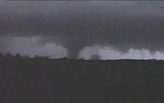 On February 10, 2009 a tornado
killed eight people in Lone Grove. The National Weather Service
classified the tornado an EF-4
with winds up to 165 mph. According to the Lone Grove city manager 114 mobile homes were destroyed, and 46 people were injured.
Some news organizations were reporting that nine people had died, but this was denied by Michelann Ooten of the Oklahoma state emergency management department.
The tornado occurred at 7:30 p.m. (CST) killing 8 and leaving 14 seriously injured. Seven were killed in Lone Grove and the other was a truck driver passing through the area. Although tornadoes are not new to the area, they are very unusual in February, and many residents were caught off guard, despite the tornado sirens. According to the National Weather Service
since 1950, the state has been struck by 44 tornadoes in the month of February.
According to the United States Census Bureau
, the city has a total area of 28.1 square miles (72.8 km²), of which 28.1 square miles (72.8 km²) of it is land and 0.04 square mile (0.1035995244 km²) of it (0.11%) is water.
of 2000, there were 4,631 people, 1,673 households, and 1,345 families residing in the city. The population density
was 165.0 people per square mile (63.7/km²). There were 1,873 housing units at an average density of 66.7 per square mile (25.8/km²). The racial makeup of the city was 84.50% White, 1.86% African American, 7.90% Native American, 0.15% Asian, 0.11% Pacific Islander, 0.52% from other races
, and 4.97% from two or more races. Hispanic or Latino of any race were 1.97% of the population.
There were 1,673 households out of which 43.8% had children under the age of 18 living with them, 65.2% were married couples
living together, 11.6% had a female householder with no husband present, and 19.6% were non-families. 17.0% of all households were made up of individuals and 6.0% had someone living alone who was 65 years of age or older. The average household size was 2.76 and the average family size was 3.11.
In the city the population was spread out with 30.9% under the age of 18, 8.4% from 18 to 24, 30.2% from 25 to 44, 21.6% from 45 to 64, and 8.9% who were 65 years of age or older. The median age was 33 years. For every 100 females there were 100.5 males. For every 100 females age 18 and over, there were 93.6 males.
The median income for a household in the city was $31,846, and the median income for a family was $38,800. Males had a median income of $30,365 versus $17,598 for females. The per capita income
for the city was $13,125. About 14.0% of families and 15.0% of the population were below the poverty line, including 18.0% of those under age 18 and 18.8% of those age 65 or over.
Carter County, Oklahoma
Carter County is a county located in the U.S. state of Oklahoma. As of 2010, the population was 47,557. Its county seat is Ardmore.Carter County is part of the Ardmore, Oklahoma, Micropolitan Statistical Area.-Geography:According to the U.S...
, Oklahoma
Oklahoma
Oklahoma is a state located in the South Central region of the United States of America. With an estimated 3,751,351 residents as of the 2010 census and a land area of 68,667 square miles , Oklahoma is the 28th most populous and 20th-largest state...
, United States
United States
The United States of America is a federal constitutional republic comprising fifty states and a federal district...
. The population was 4,631 at the 2000 census
United States Census, 2000
The Twenty-second United States Census, known as Census 2000 and conducted by the Census Bureau, determined the resident population of the United States on April 1, 2000, to be 281,421,906, an increase of 13.2% over the 248,709,873 persons enumerated during the 1990 Census...
. It is part of the Micropolitan Statistical Area
Ardmore micropolitan area
The Ardmore Micropolitan Statistical Area, as defined by the United States Census Bureau, is an area consisting of two counties in South Central Oklahoma, anchored by the city of Ardmore....
of Ardmore
Ardmore, Oklahoma
Ardmore is a business, cultural and tourism city in and the county seat of Carter County, Oklahoma, United States. As of the 2010 Census, the city had a population of 24,283, while a 2007 estimate has the Ardmore micropolitan statistical area totaling 56,694 residents...
.
The city, located seven miles west of Ardmore on U.S. Route 70
U.S. Route 70
U.S. Route 70 is an east–west United States highway that runs for 2,385 miles from eastern North Carolina to east-central Arizona. As can be derived from its number, it is a major east–west highway of the Southern and Southwestern United States...
, is effectively a bedroom community of Ardmore, with many residents employed in Ardmore.
History
A former village located in the Chickasaw NationChickasaw Nation
The Chickasaw Nation is a federally recognized Native American nation, located in Oklahoma. They are one of the members of the Five Civilized Tribes. The Five Civilized Tribes were differentiated from other Indian reservations in that they had semi-autonomous constitutional governments and...
of the Indian Territory
Indian Territory
The Indian Territory, also known as the Indian Territories and the Indian Country, was land set aside within the United States for the settlement of American Indians...
near a stand of cedar trees. The town was founded and a post office was established in Lone Grove on February 4, 1885. Prior to that the community was named "Price's Store", after local general mercantile owner T. C. "Tom Cat" Price.
During the early 1900s local businesses included three grocery stores, a barbershop, a drugstore, a movie theater, a blacksmith shop, and three doctors. Numerous oil pools, including the Healdton and Hewitt fields, were discovered nearby during the 1910s and 1920s, and the Oklahoma, New Mexico and Pacific Railway reached town in 1913. (Popularly called the Ringling Railroad, the line was later acquired by the Atchison, Topeka and Santa Fe Railway and was abandoned in 1976.) During the 1920s the community grew with the addition of a two-story Masonic lodge building, a wagonyard, a restaurant, a grist mill, a cleaning and press shop, and an automobile garage and gasoline filling station.
A fire destroyed many of the Lone Grove businesses and some homes on November 15, 1899. The city's population was reported at 215 in a 1905 geological survey of the territory. The Oklahoma, New Mexico and Pacific Railway (aka Ringling Railroad for financial backer John Nicholas Ringling; and was later absorbed into the Atchison, Topeka and Santa Fe Railway
Atchison, Topeka and Santa Fe Railway
The Atchison, Topeka and Santa Fe Railway , often abbreviated as Santa Fe, was one of the larger railroads in the United States. The company was first chartered in February 1859...
) reached Lone Grove in 1913, and was active until 1976.
In the 1910s and 1920s oil pools were discovered in nearby oilfields of Healdton and Hewitt.
After stopping a car for speeding, Oklahoma Highway Patrol
Oklahoma Highway Patrol
The Oklahoma Highway Patrol is a major state law enforcement agency of the government of Oklahoma. It is a division of the Oklahoma Department of Public Safety. The Oklahoma Highway Patrol was legislatively created in 1937 due to the growing problem of motor vehicle accidents, the expansion of a...
Trooper Howard M. Crumley was murdered with his own revolver with two shots to the head, by brothers, Ray and Hubert Wilkinson, on June 28, 1970, three miles west of Lone Grove on U.S. Highway 70.
February 2009 Tornado
February 2009 tornado outbreak
The February 2009 tornado outbreak primarily affected portions of the South Central United States on February 10, as well as sections of the Northeastern United States, on February 11. During the two-day period, 15 tornadoes touched down in seven states. Oklahoma was struck by six...
killed eight people in Lone Grove. The National Weather Service
National Weather Service
The National Weather Service , once known as the Weather Bureau, is one of the six scientific agencies that make up the National Oceanic and Atmospheric Administration of the United States government...
classified the tornado an EF-4
Enhanced Fujita Scale
The Enhanced Fujita Scale rates the strength of tornadoes in the United States based on the damage they cause.Implemented in place of the Fujita scale introduced in 1971 by Ted Fujita, it began operational use on February 1, 2007. The scale has the same basic design as the original Fujita scale:...
with winds up to 165 mph. According to the Lone Grove city manager 114 mobile homes were destroyed, and 46 people were injured.
Some news organizations were reporting that nine people had died, but this was denied by Michelann Ooten of the Oklahoma state emergency management department.
The tornado occurred at 7:30 p.m. (CST) killing 8 and leaving 14 seriously injured. Seven were killed in Lone Grove and the other was a truck driver passing through the area. Although tornadoes are not new to the area, they are very unusual in February, and many residents were caught off guard, despite the tornado sirens. According to the National Weather Service
National Weather Service
The National Weather Service , once known as the Weather Bureau, is one of the six scientific agencies that make up the National Oceanic and Atmospheric Administration of the United States government...
since 1950, the state has been struck by 44 tornadoes in the month of February.
Geography
Lone Grove is located at 34°10′39"N 97°14′55"W (34.177474, -97.248666).According to the United States Census Bureau
United States Census Bureau
The United States Census Bureau is the government agency that is responsible for the United States Census. It also gathers other national demographic and economic data...
, the city has a total area of 28.1 square miles (72.8 km²), of which 28.1 square miles (72.8 km²) of it is land and 0.04 square mile (0.1035995244 km²) of it (0.11%) is water.
Demographics
As of the censusCensus
A census is the procedure of systematically acquiring and recording information about the members of a given population. It is a regularly occurring and official count of a particular population. The term is used mostly in connection with national population and housing censuses; other common...
of 2000, there were 4,631 people, 1,673 households, and 1,345 families residing in the city. The population density
Population density
Population density is a measurement of population per unit area or unit volume. It is frequently applied to living organisms, and particularly to humans...
was 165.0 people per square mile (63.7/km²). There were 1,873 housing units at an average density of 66.7 per square mile (25.8/km²). The racial makeup of the city was 84.50% White, 1.86% African American, 7.90% Native American, 0.15% Asian, 0.11% Pacific Islander, 0.52% from other races
Race (United States Census)
Race and ethnicity in the United States Census, as defined by the Federal Office of Management and Budget and the United States Census Bureau, are self-identification data items in which residents choose the race or races with which they most closely identify, and indicate whether or not they are...
, and 4.97% from two or more races. Hispanic or Latino of any race were 1.97% of the population.
There were 1,673 households out of which 43.8% had children under the age of 18 living with them, 65.2% were married couples
Marriage
Marriage is a social union or legal contract between people that creates kinship. It is an institution in which interpersonal relationships, usually intimate and sexual, are acknowledged in a variety of ways, depending on the culture or subculture in which it is found...
living together, 11.6% had a female householder with no husband present, and 19.6% were non-families. 17.0% of all households were made up of individuals and 6.0% had someone living alone who was 65 years of age or older. The average household size was 2.76 and the average family size was 3.11.
In the city the population was spread out with 30.9% under the age of 18, 8.4% from 18 to 24, 30.2% from 25 to 44, 21.6% from 45 to 64, and 8.9% who were 65 years of age or older. The median age was 33 years. For every 100 females there were 100.5 males. For every 100 females age 18 and over, there were 93.6 males.
The median income for a household in the city was $31,846, and the median income for a family was $38,800. Males had a median income of $30,365 versus $17,598 for females. The per capita income
Per capita income
Per capita income or income per person is a measure of mean income within an economic aggregate, such as a country or city. It is calculated by taking a measure of all sources of income in the aggregate and dividing it by the total population...
for the city was $13,125. About 14.0% of families and 15.0% of the population were below the poverty line, including 18.0% of those under age 18 and 18.8% of those age 65 or over.