
Port Noarlunga, South Australia
Encyclopedia
Port Noarlunga is a suburb
in the City of Onkaparinga
, South Australia
. It is a small sea-side suburb, population 2,549, about 30 km to the south of Adelaide
and was originally created as a sea port. This area is now popular as a holiday destination or for permanent residents wishing to commute to Adelaide or work locally. There is a jetty
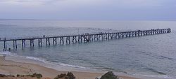
that leads nearly all the way to one of South Australia's few natural reefs. The beach is large and very long and has reasonable surfing in the South Port area whose name is taken from its location - 'South of the Port'.
The suburb is bounded to the south by the Onkaparinga River
, including a tidal estuary
. It is bounded to the west by the Gulf St Vincent and to the north and east by artificial boundaries.
was inhabited by the Kaurna tribe.
The first record of the area was provided by Captain Collet Barker
who explored the Onkaparinga River on April 15, 1831 in his search for a Gulf outlet from Lake Alexandrina. In early 1837, while camped by the Sturt River
near Marion
, South Australia's only two horses slipped their tether ropes during the night and the overseer of stock, C.W. Stuart led an expedition to recover them. Taking a botanist to record the plants encountered, the expedition searched much of present day Noarlunga before finding the horses near the Onkaparinga River. The men being on foot were however, unable to capture them. In June 1837, Colonel William Light
led an overland expedition to arrest whalers who had been abducting native women at Encounter Bay
, 100 km south of Adelaide. Cresting Tapleys Hill they named the valley Morphett Vale
after expedition member John Morphett
. They reached the southern end of the Mount Lofty Ranges
before impenetrable scrub forced them to return to Adelaide. The following year, John McLaren of the Survey Dept. divided the area south of Adelaide into three districts (B.C and D) based on the reports made by the Stuart and Light expeditions. B and C districts, the present Noarlunga District, was opened to public selection in February 1839 and by 1841 the population was estimated to be about 150. The government town of Port Noarlunga was surveyed and offered for sale on 14 April 1859.
The township was originally settled as a port for the produce from the proposed market town of Noarlunga
a few kilometres upstream. The Onkaparinga River mouth proved unsuitable to coastal ketches, so produce was barged down river to the sandhills and then taken by horse drawn rail trucks to the jetty. The current jetty was constructed in 1921 and is the second jetty to have been constructed on that site. The original jetty, 30 metres south of the current jetty, was constructed in 1855, but was destroyed in several severe storms in the early 1900s.
In the early 20th century Port Noarlunga was a popular coastal holiday destination, with the beach proving an attraction with its natural beauty and in summer amusement fairs were run, as well as row boating on the river estuary. Port Noarlunga Post Office opened around November 1909.
With the gradual incursion of urban sprawl
, and in particular immigration-fuelled expansion in the 1960s and 1970s, the township eventually became an outer suburb of Adelaide. The South Australian Housing Trust
in particular developed housing in the nearby areas of Christies Beach and O'Sullivan Beach
and with the extension of the metropolitan rail line
to adjacent Noarlunga Centre
in 1978 the township of Port Noarlunga had largely lost its attraction as a holiday destination.
It is now largely occupied by permanent residents, although it still retains much of its early village charm. The City of Onkaparinga council has assisted with maintaining this spirit of the old township, working with the State government in the late 1990s to divert through road traffic around the town centre.
 The beach and the jetty are obviously the biggest attractions to visitors. The close proximity of a diverse range of aquatic features making this area stand out from other coastal locations. A narrow reef about 400 metres offshore is approximately 1.6 km long and was formed from a consolidated Pleistocene
sand dune. The reef runs parallel to shore and has two sections, with the area separating them called The Gap.
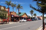
There is also a small main street (Gawler Street) that serves visitors and locals in this beach area. It has several cafes, a pub, a fish and chip shop, a surf shop and several other businesses providing services to the locals. The old "Institute" building, built in 1924, is now the community centre.
. Fishing is a popular activity from the jetty, however the reserve places a`non-fishing’ area on North Reef within 100m of reef
It is a popular scuba diving
location, with more than 200 marine plant species and over 60 fish species. There is a self guided diving trail which was established in 1994, which is marked with a series of 12 glass plaques. The plaques indicate aspects of the reef ecosystem relevant to their location.http://www.sardi.sa.gov.au/pages/fisheries/sas/postgrad/ptnoarlunga.htm
. There was a public meeting, after which a non-profit incorporated body was formed for the project.
Suburb
The word suburb mostly refers to a residential area, either existing as part of a city or as a separate residential community within commuting distance of a city . Some suburbs have a degree of administrative autonomy, and most have lower population density than inner city neighborhoods...
in the City of Onkaparinga
City of Onkaparinga
The City of Onkaparinga is a local government area located on the southern fringe of Adelaide, South Australia. It is named after the Onkaparinga River, whose name comes from Ngangkiparinga, a Kaurna word meaning "The Women's River"...
, South Australia
South Australia
South Australia is a state of Australia in the southern central part of the country. It covers some of the most arid parts of the continent; with a total land area of , it is the fourth largest of Australia's six states and two territories.South Australia shares borders with all of the mainland...
. It is a small sea-side suburb, population 2,549, about 30 km to the south of Adelaide
Adelaide
Adelaide is the capital city of South Australia and the fifth-largest city in Australia. Adelaide has an estimated population of more than 1.2 million...
and was originally created as a sea port. This area is now popular as a holiday destination or for permanent residents wishing to commute to Adelaide or work locally. There is a jetty
Jetty
A jetty is any of a variety of structures used in river, dock, and maritime works that are generally carried out in pairs from river banks, or in continuation of river channels at their outlets into deep water; or out into docks, and outside their entrances; or for forming basins along the...
that leads nearly all the way to one of South Australia's few natural reefs. The beach is large and very long and has reasonable surfing in the South Port area whose name is taken from its location - 'South of the Port'.
The suburb is bounded to the south by the Onkaparinga River
Onkaparinga River
The Onkaparinga River runs from its source between Mount Torrens and Charleston in the Mount Lofty Ranges, and flows south westerly to an estuary at Port Noarlunga. The catchment is over 500 km² in area, and is in part located in the Onkaparinga River National Park.The Onkaparinga River is the...
, including a tidal estuary
Estuary
An estuary is a partly enclosed coastal body of water with one or more rivers or streams flowing into it, and with a free connection to the open sea....
. It is bounded to the west by the Gulf St Vincent and to the north and east by artificial boundaries.
History
In pre-European times, this area along with most of the Adelaide plainsAdelaide Plains
The Adelaide Plains is the area in South Australia between the Mount Lofty Ranges on the east and Gulf St Vincent on the west. The plains are generally fertile with annual rainfall of about per year....
was inhabited by the Kaurna tribe.
The first record of the area was provided by Captain Collet Barker
Collet Barker
Collet Barker was a British military officer and explorer. He explored areas of South Australia, Western Australia and Cobourg Peninsula, Northern Territory-History:Barker was born in Hackney, he lived in Newbury as a child...
who explored the Onkaparinga River on April 15, 1831 in his search for a Gulf outlet from Lake Alexandrina. In early 1837, while camped by the Sturt River
Sturt River, Adelaide
The Sturt River is a river located in Adelaide, South Australia. Beginning in Upper Sturt in the Adelaide Hills, it flows through Coromandel Valley, the Sturt Gorge Recreation Park, Marion and Morphettville, before meeting the Patawalonga in Glenelg North. Along with Brown Hill Creek, it is one of...
near Marion
Marion, South Australia
Marion is a suburb located in the City of Marion in Adelaide around 10 km south-west from the CBD. Founded as a rural village in 1838 on the banks of the Sturt River, Marion was found to have rich soil and the population expanded rapidly...
, South Australia's only two horses slipped their tether ropes during the night and the overseer of stock, C.W. Stuart led an expedition to recover them. Taking a botanist to record the plants encountered, the expedition searched much of present day Noarlunga before finding the horses near the Onkaparinga River. The men being on foot were however, unable to capture them. In June 1837, Colonel William Light
William Light
Colonel William Light was a British military officer and the first Surveyor-General of the Colony of South Australia...
led an overland expedition to arrest whalers who had been abducting native women at Encounter Bay
Encounter Bay
Encounter Bay is located on the south central coast of South Australia, some 100 km south of Adelaide, South Australia. It is named after the encounter on 8 April 1802 between Matthew Flinders and Nicolas Baudin, both of whom were charting the Australian coastline for their respective countries...
, 100 km south of Adelaide. Cresting Tapleys Hill they named the valley Morphett Vale
Morphett Vale, South Australia
Morphett Vale is a southern suburb of Adelaide, South Australia in the City of Onkaparinga. It is the largest suburb in the state, with a population of more than 23,000 and an area of 12.76km², followed by Paralowie with nearly 10,000 fewer residents. There are approximately 1,000 businesses in...
after expedition member John Morphett
John Morphett
Sir John Morphett was a South Australian pioneer, landowner and politician.-Early life:Morphett was born in London, the second son of Nathaniel Morphett, a solicitor, and his wife Mary, née Gliddon, of Cummins, Ide, Devon, and was educated at Plymouth and Highgate Grammar Schools...
. They reached the southern end of the Mount Lofty Ranges
Mount Lofty Ranges
The Mount Lofty Ranges are the range of mountains just to the east of Adelaide in South Australia.-Location and description:The Mount Lofty Ranges stretch from the southernmost point of the Fleurieu Peninsula at Cape Jervis northwards for over before petering out north of Peterborough...
before impenetrable scrub forced them to return to Adelaide. The following year, John McLaren of the Survey Dept. divided the area south of Adelaide into three districts (B.C and D) based on the reports made by the Stuart and Light expeditions. B and C districts, the present Noarlunga District, was opened to public selection in February 1839 and by 1841 the population was estimated to be about 150. The government town of Port Noarlunga was surveyed and offered for sale on 14 April 1859.
The township was originally settled as a port for the produce from the proposed market town of Noarlunga
Old Noarlunga, South Australia
Old Noarlunga is a small town approximately 40 minutes drive south of Adelaide, South Australia. Originally settled around 1840, the town retains its village atmosphere in spite of encroaching suburbia. At the 2006 census, Old Noarlunga had a population of 1,252.-History:In 1850 the South Australia...
a few kilometres upstream. The Onkaparinga River mouth proved unsuitable to coastal ketches, so produce was barged down river to the sandhills and then taken by horse drawn rail trucks to the jetty. The current jetty was constructed in 1921 and is the second jetty to have been constructed on that site. The original jetty, 30 metres south of the current jetty, was constructed in 1855, but was destroyed in several severe storms in the early 1900s.
In the early 20th century Port Noarlunga was a popular coastal holiday destination, with the beach proving an attraction with its natural beauty and in summer amusement fairs were run, as well as row boating on the river estuary. Port Noarlunga Post Office opened around November 1909.
With the gradual incursion of urban sprawl
Urban sprawl
Urban sprawl, also known as suburban sprawl, is a multifaceted concept, which includes the spreading outwards of a city and its suburbs to its outskirts to low-density and auto-dependent development on rural land, high segregation of uses Urban sprawl, also known as suburban sprawl, is a...
, and in particular immigration-fuelled expansion in the 1960s and 1970s, the township eventually became an outer suburb of Adelaide. The South Australian Housing Trust
South Australian Housing Trust
The South Australian Housing Trust was a statutory authority established by the of the Government of South Australia responsible for providing low-cost rental housing to working people and their families.-History:...
in particular developed housing in the nearby areas of Christies Beach and O'Sullivan Beach
O'Sullivan Beach, South Australia
O'Sullivans Beach is a seaside suburb in the southern Adelaide metropolitan area, within the City of Onkaparinga. O'Sullivans Beach has a unique postcode of 5166, and is adjacent to the suburbs of Christies Beach and Noarlunga Centre to the south east, Christies Beach to the south, and Port...
and with the extension of the metropolitan rail line
Rail transport
Rail transport is a means of conveyance of passengers and goods by way of wheeled vehicles running on rail tracks. In contrast to road transport, where vehicles merely run on a prepared surface, rail vehicles are also directionally guided by the tracks they run on...
to adjacent Noarlunga Centre
Noarlunga Centre, South Australia
Noarlunga Centre is a suburb in the City of Onkaparinga in the southern suburbs of Adelaide, South Australia. The suburb is purely commercial, being dominated by the Centro Colonnades shopping centre. Thus there are no private residents. The suburb is bordered by Beach Road to the north, Dyson Road...
in 1978 the township of Port Noarlunga had largely lost its attraction as a holiday destination.
It is now largely occupied by permanent residents, although it still retains much of its early village charm. The City of Onkaparinga council has assisted with maintaining this spirit of the old township, working with the State government in the late 1990s to divert through road traffic around the town centre.
Attractions
Pleistocene
The Pleistocene is the epoch from 2,588,000 to 11,700 years BP that spans the world's recent period of repeated glaciations. The name pleistocene is derived from the Greek and ....
sand dune. The reef runs parallel to shore and has two sections, with the area separating them called The Gap.
There is also a small main street (Gawler Street) that serves visitors and locals in this beach area. It has several cafes, a pub, a fish and chip shop, a surf shop and several other businesses providing services to the locals. The old "Institute" building, built in 1924, is now the community centre.
Onkaparinga Aquatic Reserve/Underwater Trail
The Port Noarlunga Reef and Onkaparinga Estuary Aquatic Reserve was the first proclaimed reef reserve in South Australia, being established in 1971 to protect the reef life and adjacent river estuary. The boundaries of the reserve were extended in 1993 to include the adjacent limestone reef of Horseshoe Reef at Christies BeachChristies Beach, South Australia
Christies Beach is a seaside suburb in the southern Adelaide metropolitan area, within the City of Onkaparinga. The area is scenic and hence popular with photographers as Witton Bluff provides a natural vantage point over the entire suburb and beyond....
. Fishing is a popular activity from the jetty, however the reserve places a`non-fishing’ area on North Reef within 100m of reef
It is a popular scuba diving
Scuba diving
Scuba diving is a form of underwater diving in which a diver uses a scuba set to breathe underwater....
location, with more than 200 marine plant species and over 60 fish species. There is a self guided diving trail which was established in 1994, which is marked with a series of 12 glass plaques. The plaques indicate aspects of the reef ecosystem relevant to their location.http://www.sardi.sa.gov.au/pages/fisheries/sas/postgrad/ptnoarlunga.htm
Port Noarlunga Aquatic Centre
Since 1976 the Port Noarlunga Aquatic Centre has operated classes for primary school children from throughout the state. The program runs in the first and last school terms each year and provides the opportunity to try waveskiing, canoeing, fishing, snorkelling, sailing, swimming and sailboarding. About 15,000 students have access to this program each year.Onkaparinga Community Playground
In the south of the suburb there is a large community playground. This is a community built playground and as such is unique to South Australia. A$250 000 was raised from community sponsorship before the playground was built using community labour over the period of 18–23 June 2002. This project began after research by "Living Neighbourhood" in nearby Christies BeachChristies Beach, South Australia
Christies Beach is a seaside suburb in the southern Adelaide metropolitan area, within the City of Onkaparinga. The area is scenic and hence popular with photographers as Witton Bluff provides a natural vantage point over the entire suburb and beyond....
. There was a public meeting, after which a non-profit incorporated body was formed for the project.