
Supercell
Encyclopedia

Thunderstorm
A thunderstorm, also known as an electrical storm, a lightning storm, thundershower or simply a storm is a form of weather characterized by the presence of lightning and its acoustic effect on the Earth's atmosphere known as thunder. The meteorologically assigned cloud type associated with the...
that is characterized by the presence of a mesocyclone
Mesocyclone
A mesocyclone is a vortex of air, approximately 2 to 10 miles in diameter , within a convective storm....
: a deep, continuously-rotating updraft
Vertical draft
An updraft or downdraft is the vertical movement of air as a weather related phenomenon. One of two forces causes the air to move. Localized regions of warm or cool air will exhibit vertical movement. A mass of warm air will typically be less dense than the surrounding region, and so will rise...
. For this reason, these storms are sometimes referred to as rotating thunderstorms. Of the four classifications of thunderstorms (supercell, squall line
Squall line
A squall line is a line of severe thunderstorms that can form along or ahead of a cold front. In the early 20th century, the term was used as a synonym for cold front. It contains heavy precipitation, hail, frequent lightning, strong straight-line winds, and possibly tornadoes and waterspouts....
, multi-cell, and single-cell
Pulse storm
A pulse storm is a single cell thunderstorm that is usually not very strong; when it is of substantial intensity, it only produces severe weather for short periods of time...
), supercells are the overall least common and have the potential to be the most severe. Supercells are often isolated from other thunderstorms, and can dominate the local climate up to 32 kilometres (20 mi) away.
Supercells are often put into two classification types: Low-precipitation (LP) and High-precipitation (HP). LP supercells are usually found in climates that are more arid, such as the high plains of the United States, and HP supercells are most often found in moist climates. Supercells can occur anywhere in the world under the right pre-existing weather conditions, but they are most common in the Great Plains
Great Plains
The Great Plains are a broad expanse of flat land, much of it covered in prairie, steppe and grassland, which lies west of the Mississippi River and east of the Rocky Mountains in the United States and Canada. This area covers parts of the U.S...
of the United States.
Characteristics
Supercells are usually found isolated from other thunderstorms, although they can sometimes be embedded in a squall lineSquall line
A squall line is a line of severe thunderstorms that can form along or ahead of a cold front. In the early 20th century, the term was used as a synonym for cold front. It contains heavy precipitation, hail, frequent lightning, strong straight-line winds, and possibly tornadoes and waterspouts....
. Because they can last for hours, they are known as quasi-steady-state storms. Supercells have the capability to deviate from the mean wind. If they track to the right or left of the mean wind (relative to the vertical wind shear
Wind shear
Wind shear, sometimes referred to as windshear or wind gradient, is a difference in wind speed and direction over a relatively short distance in the atmosphere...
), they are said to be "right-movers" or "left-movers," respectively. Supercells can sometimes develop two separate updrafts with opposing rotations, which splits the storm into two supercells: one left-mover and one right-mover.
Supercells can be any size – large or small, low or high topped. They usually produce copious amounts of hail
Hail
Hail is a form of solid precipitation. It consists of balls or irregular lumps of ice, each of which is referred to as a hail stone. Hail stones on Earth consist mostly of water ice and measure between and in diameter, with the larger stones coming from severe thunderstorms...
, torrential rain
Rain
Rain is liquid precipitation, as opposed to non-liquid kinds of precipitation such as snow, hail and sleet. Rain requires the presence of a thick layer of the atmosphere to have temperatures above the melting point of water near and above the Earth's surface...
fall, strong wind
Wind
Wind is the flow of gases on a large scale. On Earth, wind consists of the bulk movement of air. In outer space, solar wind is the movement of gases or charged particles from the sun through space, while planetary wind is the outgassing of light chemical elements from a planet's atmosphere into space...
s, and substantial downbursts. Supercells are one of the few types of clouds that typically spawn tornado
Tornado
A tornado is a violent, dangerous, rotating column of air that is in contact with both the surface of the earth and a cumulonimbus cloud or, in rare cases, the base of a cumulus cloud. They are often referred to as a twister or a cyclone, although the word cyclone is used in meteorology in a wider...
es within the mesocyclone, although only 30% or less do so.
Geography
Supercells can occur anywhere in the world under the right weather conditions. According to some, the first storm to be identified as such was the WokinghamWokingham
Wokingham is a market town and civil parish in Berkshire in South East England about west of central London. It is about east-southeast of Reading and west of Bracknell. It spans an area of and, according to the 2001 census, has a population of 30,403...
storm over England
England
England is a country that is part of the United Kingdom. It shares land borders with Scotland to the north and Wales to the west; the Irish Sea is to the north west, the Celtic Sea to the south west, with the North Sea to the east and the English Channel to the south separating it from continental...
, which was studied by Keith Browning
Keith Browning
Keith Browning is a British meteorologist who worked at Imperial College London, the Met Office and University of Reading department of meteorology. His work with Frank Ludlam on the supercell thunderstorm at Wokingham, UK in 1962 was the first detailed study of such a storm...
and Frank Ludlam in 1962. Supercells are most frequent in the Great Plains
Great Plains
The Great Plains are a broad expanse of flat land, much of it covered in prairie, steppe and grassland, which lies west of the Mississippi River and east of the Rocky Mountains in the United States and Canada. This area covers parts of the U.S...
of the United States
United States
The United States of America is a federal constitutional republic comprising fifty states and a federal district...
and eastern Australia, but occasionally occur in many mid-latitude regions.
Anatomy of a supercell
The current conceptual model of a supercell was described in Severe Thunderstorm Evolution and Mesocyclone Structure as Related to Tornadogenesis by Leslie R. Lemon and Charles A. Doswell III. (See Lemon techniqueLemon technique
The Lemon technique is a method used by meteorologists using weather radar to determine the relative strength of thunderstorm cells in a vertically sheared environment. It is named for Leslie R. Lemon, the co-creator of the current conceptual model of a supercell. The Lemon technique is largely a...
).
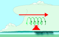
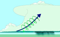
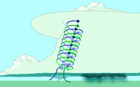
Supercells derive their rotation through tilting of horizontal vorticity (an invisible horizontal vortex
Vortex
A vortex is a spinning, often turbulent,flow of fluid. Any spiral motion with closed streamlines is vortex flow. The motion of the fluid swirling rapidly around a center is called a vortex...
) caused by wind shear
Wind shear
Wind shear, sometimes referred to as windshear or wind gradient, is a difference in wind speed and direction over a relatively short distance in the atmosphere...
. Strong updrafts lift the air turning about a horizontal axis and cause this air to turn about a vertical axis. This forms the deep rotating updraft, the mesocyclone
Mesocyclone
A mesocyclone is a vortex of air, approximately 2 to 10 miles in diameter , within a convective storm....
.
A cap or capping inversion
Capping inversion
A capping inversion is an elevated inversion layer that caps a convective boundary layer.The boundary layer is the part of the atmosphere which is closest to the ground. Normally, the sun heats the ground, which in turn heats the air just above it. Thermals form when this warm air rises into the...
is usually required to form an updraft of sufficient strength. The cap puts an inverted (cold-above-warm) layer above a normal (warm-above-cold) boundary layer
Boundary layer
In physics and fluid mechanics, a boundary layer is that layer of fluid in the immediate vicinity of a bounding surface where effects of viscosity of the fluid are considered in detail. In the Earth's atmosphere, the planetary boundary layer is the air layer near the ground affected by diurnal...
, and by preventing warm surface air from rising, allows one or both of the following:
- Air below the cap warms and/or becomes more moist
- Air above the cap cools
This creates a warmer, moister layer below a cooler layer, which is increasingly unstable (because warm air is less dense and tends to rise). When the cap weakens or moves, explosive development follows.
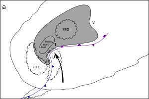
In North America, supercells usually show up on Doppler radar as starting at a point or hook shape on the southwestern side, fanning out to the northeast. The heaviest precipitation is usually on the southwest side, ending abruptly short of the rain-free updraft base or main updraft (not visible to radar). The rear flank downdraft
Rear flank downdraft
The rear flank downdraft or RFD is a region of dry air wrapping around the back of a mesocyclone in a supercell thunderstorm. These areas of descending air are thought to be essential in the production of many supercellular tornadoes...
, or RFD, carries precipitation counterclockwise around the north and northwest side of the updraft base, producing a "hook echo
Hook echo
The hook echo is one of the classical hallmarks of tornado-producing supercell thunderstorms as seen on a weather radar. The echo is produced by rain, hail, or even debris being wrapped around the supercell...
" that indicates the presence of a mesocyclone.
 |
 |
 |
Features of a supercell
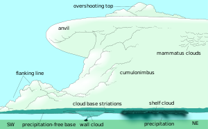
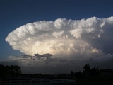
- Overshooting top
This "dome" feature appears above the anvil of the storm. It is a result of the powerful updraft. If an observer at ground level is too close to the storm, they cannot see the overshooting top.
- Anvil
Formed in the uppermost parts of thunderstorm, the anvil is cold and virtually precipitation free. Since there is so little moisture in the anvil, winds can move freely. The clouds take on their anvil shape when the rising air reaches 40,000-60,000 or more feet. The anvil's distinguishing feature is that it juts out in front of the storm like a shelf.
- Precipitation-free base
This area, typically on the southern side of the storm in North America, is relatively precipitation free. This is located beneath the main updraft, and is the main area of inflow. While no precipitation may be visible to an observer, large hail and rain may be falling from this area. It is more accurately called the main updraft area.
- Wall cloud
The wall cloud
Wall cloud
A wall cloud is a large, lowering, and rotating base of a cumulonimbus cloud that potentially forms tornadoes. It is typically beneath the rain-free base portion of a deep cumulus cloud , and indicates the area of primary and strongest updraft which condenses into cloud at altitudes lower than...
forms near the downdraft/updraft interface. This "interface" is the area between the precipitation area and the precipitation-free base. Wall clouds form when rain-cooled air from the downdraft is pulled into the updraft. This wet, cold air quickly saturates as it is lifted by the updraft, forming a cloud that seems to "descend" from the precipitation-free base. Wall clouds are common and are not exclusive to supercells: Only a few actually produce a tornado. Wall clouds that persist for more than ten minutes, wall clouds that seem to move violently up or down, and violent movements of cloud fragments (scud or fractus) near the wall cloud are indications that a tornado could form.
- Mammatus clouds
Mammatus
Mammatus cloud
Mammatus, also known as mammatocumulus , is a meteorological term applied to a cellular pattern of pouches hanging underneath the base of a cloud...
(Mamma, Mammatocumulus) are bulbous or pillow-like cloud formations extending from beneath the anvil of a thunderstorm. These clouds form as cold air in the anvil region of a storm sinks into warmer air beneath it. Mammatus are most apparent when they are lit from one side or below and are therefore at their most impressive near sunset or shortly after sunrise when the sun is low in the sky. Mammatus are not exclusive to supercells and can be associated with developed thunderstorms and cumulonimbus.
- Precipitation area
This is the area of heaviest precipitation. Between the precipitation-free base and the precipitation area, a "vaulted" or "cathedral" feature can be observed. In high precipitation supercells an area of heavy precipitation may occur beneath the main updraft area.
- Flanking line
A line of smaller cumulonimbi
Cumulonimbus cloud
Cumulonimbus is a towering vertical cloud that is very tall, dense, and involved in thunderstorms and other inclement weather. Cumulonimbus originates from Latin: Cumulus "Heap" and nimbus "rain". It is a result of atmospheric instability. These clouds can form alone, in clusters, or along a cold...
or cumulus that form in the warm rising air pulled in by the main updraft. Due to convergence and lifting along this line, landspouts sometimes occur in this region.
Radar features of a supercell
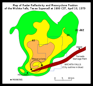
- Hook echoHook echoThe hook echo is one of the classical hallmarks of tornado-producing supercell thunderstorms as seen on a weather radar. The echo is produced by rain, hail, or even debris being wrapped around the supercell...
or Pendant
The "hook echo" is the area of confluence between the main updraft and the rear flank downdraft (RFD). This indicates the position of the mesocyclone, and likely a tornado.
- Bounded weak echo region (or BWER)
This is a region of low radar reflectivity bounded above by an area of higher radar reflectivity with an untilted updraft
Tilted updraft
A tilted updraft is a thunderstorm which is not vertically erect. This happens as a result of unidirectional wind shear, or a change in wind speed with height. In such an environment, the top of the updraft is pushed further downstream than the lower parts as a result of stronger winds pushing...
. This is evidence of a strong updraft.
- Inflow notch
A "notch" of weak reflectivity on the inflow side of the cell. This is not a V-Notch.
- V Notch
A "V" shaped notch on the leading edge of the cell, opening away from the main downdraft. This is an indication of divergent flow around a powerful updraft.
- Hail spike
This three body scatter spike
Three body scatter spike
A hail spike or three body scatter spike is an artifact on a weather radar display indicative of large hail. They are identified by a spike of weak reflectivity echoes that extend out from a thunderstorm, and away from the radar site.- Cause :...
is a region of weak echoes found radially behind the main reflectivity core at higher elevations when large hail is present.
Supercell variations
Supercell thunderstorms are sometimes classified by meteorologists and storm spottersSkywarn
SKYWARN is a program of the United States' National Weather Service . Its mission is to collect reports of localized severe weather. These reports are used to aid forecasters in issuing and verifying severe weather watches and warnings and to improve the forecasting and warning processes and the...
into three categories. However, not all supercells fit neatly into any one category, and many resemble all three at different times during the lifespan of the storm. The standard definition given above is referred to as the Classic supercell. All types of supercells can produce severe weather.
Low Precipitation (LP)
LP supercells contain a small precipitation (rain/hail) core separate from the updraft. This type of supercell may be easily identifiable with "sculpted" cloud striations in the updraft base or even a "corkscrewed" or "barber pole" appearance on the updraft, and sometimes an almost "anorexic" look compared to classic supercells. This is because they often form along dry lineDry line
A dry line separates moist air from the Gulf of Mexico and dry desert air from the south-western states . The dry line is an important factor in severe weather frequency in the Great Plains of North America...
s, thus leaving them with little available moisture despite high upper level wind shear. They usually dissipate rapidly rather than turning into classic or HP supercells, although it is still not unusual for them to do the latter, especially if they happen to collide with a much moister air mass along the way. Although these storms usually produce weak tornadoes, they have been known to produce strong ones. These storms usually produce hail less than 1.00 inch in diameter but can produce large hail even with little or no visible precipitation core, making them hazardous to storm chaser
Storm chaser
Storm chaser can refer to:*Storm chasing, the pursuit of any severe weather condition*Storm Chaser, registered US Service Mark for Warren Faidley confirmed by the US Trademark Office as the first, full-time, professional storm chasing journalist...
s and people and animals caught outside. Due to the lack of a heavy precipitation core, LP supercells can sometimes show weak radar reflectivity without clear evidence of a hook echo
Hook echo
The hook echo is one of the classical hallmarks of tornado-producing supercell thunderstorms as seen on a weather radar. The echo is produced by rain, hail, or even debris being wrapped around the supercell...
, when in fact they are producing a tornado at the time. This is where observations by storm spotter
Skywarn
SKYWARN is a program of the United States' National Weather Service . Its mission is to collect reports of localized severe weather. These reports are used to aid forecasters in issuing and verifying severe weather watches and warnings and to improve the forecasting and warning processes and the...
and storm chaser
Storm chaser
Storm chaser can refer to:*Storm chasing, the pursuit of any severe weather condition*Storm Chaser, registered US Service Mark for Warren Faidley confirmed by the US Trademark Office as the first, full-time, professional storm chasing journalist...
s may be of vital importance. Funnel cloud
Funnel cloud
A funnel cloud is a funnel-shaped cloud of condensed water droplets, associated with a rotating column of wind and extending from the base of a cloud but not reaching the ground or a water surface. A funnel cloud is usually visible as a cone-shaped or needle like protuberance from the main cloud...
s, or more rarely, weak tornado
Tornado
A tornado is a violent, dangerous, rotating column of air that is in contact with both the surface of the earth and a cumulonimbus cloud or, in rare cases, the base of a cumulus cloud. They are often referred to as a twister or a cyclone, although the word cyclone is used in meteorology in a wider...
es will sometimes form midway between the base and the top of the storm, descending from the main Cb (cumulonimbus
Cumulonimbus cloud
Cumulonimbus is a towering vertical cloud that is very tall, dense, and involved in thunderstorms and other inclement weather. Cumulonimbus originates from Latin: Cumulus "Heap" and nimbus "rain". It is a result of atmospheric instability. These clouds can form alone, in clusters, or along a cold...
) cloud. Lightning is rare compared to other supercell types, but it is not unknown and is more likely to occur as intracloud lightning rather than cloud-to-ground lightning. In North America
North America
North America is a continent wholly within the Northern Hemisphere and almost wholly within the Western Hemisphere. It is also considered a northern subcontinent of the Americas...
, these storms almost exclusively form in the semi-arid Great Plains
Great Plains
The Great Plains are a broad expanse of flat land, much of it covered in prairie, steppe and grassland, which lies west of the Mississippi River and east of the Rocky Mountains in the United States and Canada. This area covers parts of the U.S...
during the spring and summer months. Moving east and southeast, they often collide with moist air masses from the Gulf of Mexico, leading to the formation of HP supercells in areas just to the west of Interstate 35
Interstate 35
Interstate 35 is a north–south Interstate Highway in the central United States. I-35 stretches from Laredo, Texas, on the U.S.-Mexico border to Duluth, Minnesota, at Minnesota Highway 61 and 26th Avenue East. Many interstates used to have splits or spurs indicated with suffixed letters , but I-35...
before dissipating further east. LP supercells can occur as far north as Montana
Montana
Montana is a state in the Western United States. The western third of Montana contains numerous mountain ranges. Smaller, "island ranges" are found in the central third of the state, for a total of 77 named ranges of the Rocky Mountains. This geographical fact is reflected in the state's name,...
, North Dakota
North Dakota
North Dakota is a state located in the Midwestern region of the United States of America, along the Canadian border. The state is bordered by Canada to the north, Minnesota to the east, South Dakota to the south and Montana to the west. North Dakota is the 19th-largest state by area in the U.S....
and even in the provinces of Alberta
Alberta
Alberta is a province of Canada. It had an estimated population of 3.7 million in 2010 making it the most populous of Canada's three prairie provinces...
and Saskatchewan
Saskatchewan
Saskatchewan is a prairie province in Canada, which has an area of . Saskatchewan is bordered on the west by Alberta, on the north by the Northwest Territories, on the east by Manitoba, and on the south by the U.S. states of Montana and North Dakota....
in Canada
Canada
Canada is a North American country consisting of ten provinces and three territories. Located in the northern part of the continent, it extends from the Atlantic Ocean in the east to the Pacific Ocean in the west, and northward into the Arctic Ocean...
. They have also been observed by storm chasers in Australia
Australia
Australia , officially the Commonwealth of Australia, is a country in the Southern Hemisphere comprising the mainland of the Australian continent, the island of Tasmania, and numerous smaller islands in the Indian and Pacific Oceans. It is the world's sixth-largest country by total area...
.
LP supercells are quite sought after by storm chasers, because the limited amount of precipitation makes sighting tornadoes at a safe distance much less difficult than with a Classic or HP supercell. During spring and early summer, areas in which LP supercells are readily spotted include southwestern Oklahoma
Oklahoma
Oklahoma is a state located in the South Central region of the United States of America. With an estimated 3,751,351 residents as of the 2010 census and a land area of 68,667 square miles , Oklahoma is the 28th most populous and 20th-largest state...
and northwestern Texas
Texas
Texas is the second largest U.S. state by both area and population, and the largest state by area in the contiguous United States.The name, based on the Caddo word "Tejas" meaning "friends" or "allies", was applied by the Spanish to the Caddo themselves and to the region of their settlement in...
, among other parts of the western Great Plains
Great Plains
The Great Plains are a broad expanse of flat land, much of it covered in prairie, steppe and grassland, which lies west of the Mississippi River and east of the Rocky Mountains in the United States and Canada. This area covers parts of the U.S...
.

High Precipitation (HP)
The HP supercell has a much heavier precipitation core that can wrap all the way around the mesocyclone. These are especially dangerous storms, since the mesocyclone is wrapped with rain and can hide the tornado from view. These storms also cause flooding due to heavy rain, damaging downburstDownburst
A downburst is created by an area of significantly rain-cooled air that, after reaching ground level, spreads out in all directions producing strong winds. Unlike winds in a tornado, winds in a downburst are directed outwards from the point where it hits land or water...
s and weak tornadoes, although they are also known to produce strong to violent tornadoes. They have a lower potential for damaging hail than Classic and LP supercells, although damaging hail is possible. It has been observed by some spotters that they tend to produce more cloud-to-ground and intracloud lightning than the other types. Also, unlike the LP and Classic types, severe events usually occur at the front (southeast) of the storm. The HP supercell is the most common type of supercell in the United States
United States
The United States of America is a federal constitutional republic comprising fifty states and a federal district...
east of Interstate 35
Interstate 35
Interstate 35 is a north–south Interstate Highway in the central United States. I-35 stretches from Laredo, Texas, on the U.S.-Mexico border to Duluth, Minnesota, at Minnesota Highway 61 and 26th Avenue East. Many interstates used to have splits or spurs indicated with suffixed letters , but I-35...
and in the southern parts of the provinces of Ontario
Ontario
Ontario is a province of Canada, located in east-central Canada. It is Canada's most populous province and second largest in total area. It is home to the nation's most populous city, Toronto, and the nation's capital, Ottawa....
and Quebec
Quebec
Quebec or is a province in east-central Canada. It is the only Canadian province with a predominantly French-speaking population and the only one whose sole official language is French at the provincial level....
in Canada
Canada
Canada is a North American country consisting of ten provinces and three territories. Located in the northern part of the continent, it extends from the Atlantic Ocean in the east to the Pacific Ocean in the west, and northward into the Arctic Ocean...
.
Effects
Tornado
A tornado is a violent, dangerous, rotating column of air that is in contact with both the surface of the earth and a cumulonimbus cloud or, in rare cases, the base of a cumulus cloud. They are often referred to as a twister or a cyclone, although the word cyclone is used in meteorology in a wider...
es, flooding, dangerous cloud-to-ground lightning
Lightning
Lightning is an atmospheric electrostatic discharge accompanied by thunder, which typically occurs during thunderstorms, and sometimes during volcanic eruptions or dust storms...
, and heavy rain.
Severe events associated with a supercell almost always occur in the area of the updraft/downdraft interface. In the Northern Hemisphere
Northern Hemisphere
The Northern Hemisphere is the half of a planet that is north of its equator—the word hemisphere literally means “half sphere”. It is also that half of the celestial sphere north of the celestial equator...
, this is most often the rear flank (southwest side) of the precipitation area in LP and classic supercells, but sometimes the leading edge (southeast side) of HP supercells.
While tornadoes are perhaps the most dramatic of these severe events, all are dangerous. High winds caused by powerful outflow can reach over 148 km/h (92 mph) and downburst
Downburst
A downburst is created by an area of significantly rain-cooled air that, after reaching ground level, spreads out in all directions producing strong winds. Unlike winds in a tornado, winds in a downburst are directed outwards from the point where it hits land or water...
s can cause tornado-like damage. Flooding is the leading cause of death associated with severe weather.
Note that none of these severe events are exclusive to supercells, although these events are highly predictable once a supercell has formed.
Examples
The supercell is a global phenomenon, as evidenced by these examples.Asia
Some reports suggest that the deluge on 26 July 2005 in Mumbai, India was caused by a supercell when there was a cloud formation 15 kilometres (49,212.6 ft) high over the city. On this day 944 mm (37.2 in) of rain fell over the city, of which 700 mm (27.6 in) fell in just four hours. The rainfall coincided with a high tide, which exacerbated conditions.Australia
On April 14, 1999, a severe storm later classified as a supercell hit the east coast of New South Wales. It is estimated that the storm dropped 500,000 tonnes worth of hailstones during its course. At the time it was the most costly disaster in Australia's insurance history, causing an approximated A$2.3 billion worth of damage, of which A$1.7 billion was covered by insurance.On February 27, 2007 a supercell hit Canberra, dumping nearly one metre of ice in Civic. The ice was so heavy that a newly built shopping center's roof collapsed, birds were killed in the hail produced from the supercell, and people were stranded. The following day many homes in Canberra were subjected to flash flooding, caused either by storm water infrastructure's inability to cope or through mud slides from cleared land.
In 2010, on 6 March, supercell storms
2010 Victorian storms
The 2010 Victorian storms were a series of storms that passed through much of the Australian state of Victoria on 6 March and 7 March 2010. One of the most severe storms passed directly over Greater Melbourne, bringing lightning, flash flooding, very large hail and strong winds to the state's capital...
hit Melbourne
Melbourne
Melbourne is the capital and most populous city in the state of Victoria, and the second most populous city in Australia. The Melbourne City Centre is the hub of the greater metropolitan area and the Census statistical division—of which "Melbourne" is the common name. As of June 2009, the greater...
. The storms caused flash flooding in the center of the city and tennis ball-sized (10 cm (4 in)) hailstones hit cars and buildings, causing more than $220 million worth of damage, and sparking 40,000-plus insurance claims. In just 18 minutes, 19 mm (0.748031496062992 in) of rain fell, causing havoc as streets were flooded and trains, planes and cars were brought to a standstill.
That same month, on March 22, 2010
2010 Western Australian storms
The 2010 Western Australian storms were a series of storms that travelled over south-western Western Australia on 21 and 22 March 2010. One of the more intense storm cells passed directly over the capital city of Perth between 3:30pm and 5:00pm on Monday 22 March 2010...
a supercell hit Perth
Perth, Western Australia
Perth is the capital and largest city of the Australian state of Western Australia and the fourth most populous city in Australia. The Perth metropolitan area has an estimated population of almost 1,700,000....
. This storm was one of the worst in the city's history, causing six centimeter-sized (6 centimetres (2.4 in)) hail stones and torrential rain. The city had its average March rainfall in just seven minutes during the storm. Hail stones caused severe property damage, from dented cars to smashed windows. The storm itself caused more than 100 million dollars in damage.
Europe
In 2009, on the night of Monday May 25, a supercell formed over BelgiumBelgium
Belgium , officially the Kingdom of Belgium, is a federal state in Western Europe. It is a founding member of the European Union and hosts the EU's headquarters, and those of several other major international organisations such as NATO.Belgium is also a member of, or affiliated to, many...
. It was described by Belgian meteorologist Frank Deboosere as "one of the worst storms in recent years" and caused much damage in Belgium - mainly in the provinces of East Flanders (around Ghent), Flemish Brabant (around Brussels) and Antwerp. The storm occurred between about 1:00am and 4:00am local time. An incredible 30,000 lightning flashes were recorded in 2 hours - including 10,000 cloud-to-ground strikes. Hailstones up to 6 centimetres (2.4 in) across were observed in some places and wind gusts over 90 km/h (55.9 mph); in Melle near Ghent a gust of 101 km/h (62.8 mph) was reported. Trees were uprooted and blown onto several motorways. In Lillo (east of Antwerp) a loaded goods train was blown from the rail tracks.
On August 18th, 2011, the rock festival Pukkelpop
Pukkelpop
Pukkelpop is an annual music festival which takes place near the city of Hasselt, Belgium in mid-to-late August. It is held within a large enclosure of fields and woodland—between a dual carriageway called Kempische Steenweg—in the village of Kiewit, approximately 7 km north of Hasselt...
in Kiewit, Hasselt (Belgium) may have been seized by a supercell
Supercell
A supercell is a thunderstorm that is characterized by the presence of a mesocyclone: a deep, continuously-rotating updraft. For this reason, these storms are sometimes referred to as rotating thunderstorms...
with mesocyclone
Mesocyclone
A mesocyclone is a vortex of air, approximately 2 to 10 miles in diameter , within a convective storm....
around 18:15. Tornado-like winds were reported, trees of over 30 centimetres (11.8 in) diameter were felled and tents came down. Severe hail scourged the campus. Five people reportedly died and over 140 people were injured. One more died a week later. The event was suspended. Buses and trains were mobilised to bring people home.
North America
Tornado AlleyTornado Alley
Tornado Alley is a colloquial and popular media term that most often refers to the area of the United States where tornadoes are most frequent. Although an official location is not defined, the area between the Rocky Mountains and Appalachian Mountains is usually associated with it.The areas...
is a region of the United States where severe weather is common. Supercell thunderstorms can sweep through any time between March and November, but are concentrated in the spring. Tornado watches
Tornado watch
A tornado watch is issued when conditions are right for a tornado to form. Since any thunderstorm capable of producing a tornado is defined as severe, a tornado watch is also automatically a severe thunderstorm watch...
and warnings
Tornado warning
A tornado warning is an alert issued by government weather services to warn that severe thunderstorms with tornadoes may be imminent. It can be issued after a tornado or funnel cloud has been spotted by eye, or more commonly if there are radar indications of tornado formation...
are frequently necessary in the spring and summer.
Gainesville, Georgia was the site of the fifth deadliest tornado in U.S. history in 1936, where Gainesville was devastated and 203 people were killed.
The 1980 Grand Island tornado outbreak affected the city of Grand Island, Nebraska on June 3, 1980. Seven tornadoes touched down in or near the city that night, killing 5 and injuring 200.
The Elie, Manitoba tornado
Elie, Manitoba Tornado
The Elie, Manitoba Tornado was an F5 tornado that struck the town of Elie, Manitoba, Canada, on June 22, 2007. While several houses were leveled, no one was injured or killed by the tornado. Two well-built homes in the town were swept clean off of their foundations, justifying the F5...
was an F5
Fujita scale
The Fujita scale , or Fujita-Pearson scale, is a scale for rating tornado intensity, based primarily on the damage tornadoes inflict on human-built structures and vegetation...
that struck the town of Elie, Manitoba on June 22, 2007. While several houses were leveled, no one was injured or killed by the tornado.
South Africa
South Africa witnesses several supercell thunderstorms each year with the inclusion of isolated tornadoes. On most occasions these tornadoes occur in open farmlands and rarely does damage to property, as such many of the tornadoes which do occur in South Africa are not reported. The majority of supercells develop in the central, northern and north eastern parts of the country. The Free State, Gauteng and Kwazulu Natal are typically the provinces where these storms are most commonly experienced, though supercell activity is most certainly not limited to these provinces. On occasion hail reaches sizes in excess of golf balls with as mentioned above, the rare formation of tornadoes.On the 6 May 2009 a well defined hook echo was noticed on local South African radars, along with satellite imagery this supported the presence of a strong supercell storm. Reports from the area indicated heavy rains, winds and large hail.