

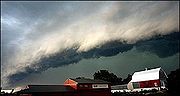
Squall line
Encyclopedia
Cold front
A cold front is defined as the leading edge of a cooler mass of air, replacing a warmer mass of air.-Development of cold front:The cooler and denser air wedges under the less-dense warmer air, lifting it...
. In the early 20th century, the term was used as a synonym for cold front
Cold front
A cold front is defined as the leading edge of a cooler mass of air, replacing a warmer mass of air.-Development of cold front:The cooler and denser air wedges under the less-dense warmer air, lifting it...
. It contains heavy precipitation
Precipitation (meteorology)
In meteorology, precipitation In meteorology, precipitation In meteorology, precipitation (also known as one of the classes of hydrometeors, which are atmospheric water phenomena is any product of the condensation of atmospheric water vapor that falls under gravity. The main forms of precipitation...
, hail
Hail
Hail is a form of solid precipitation. It consists of balls or irregular lumps of ice, each of which is referred to as a hail stone. Hail stones on Earth consist mostly of water ice and measure between and in diameter, with the larger stones coming from severe thunderstorms...
, frequent lightning
Lightning
Lightning is an atmospheric electrostatic discharge accompanied by thunder, which typically occurs during thunderstorms, and sometimes during volcanic eruptions or dust storms...
, strong straight-line wind
Wind
Wind is the flow of gases on a large scale. On Earth, wind consists of the bulk movement of air. In outer space, solar wind is the movement of gases or charged particles from the sun through space, while planetary wind is the outgassing of light chemical elements from a planet's atmosphere into space...
s, and possibly tornado
Tornado
A tornado is a violent, dangerous, rotating column of air that is in contact with both the surface of the earth and a cumulonimbus cloud or, in rare cases, the base of a cumulus cloud. They are often referred to as a twister or a cyclone, although the word cyclone is used in meteorology in a wider...
es and waterspouts. Strong straight-line winds can occur where the squall line is in the shape of a bow echo
Bow echo
A bow echo is a term describing the characteristic radar return from a mesoscale convective system that is shaped like an archer’s bow. These systems can produce severe straight-line winds and occasionally tornadoes, causing major damage.-Research:...
. Tornado
Tornado
A tornado is a violent, dangerous, rotating column of air that is in contact with both the surface of the earth and a cumulonimbus cloud or, in rare cases, the base of a cumulus cloud. They are often referred to as a twister or a cyclone, although the word cyclone is used in meteorology in a wider...
es can be found along waves within a line echo wave pattern, or LEWP, where mesoscale low pressure area
Low pressure area
A low-pressure area, or "low", is a region where the atmospheric pressure at sea level is below that of surrounding locations. Low-pressure systems form under areas of wind divergence which occur in upper levels of the troposphere. The formation process of a low-pressure area is known as...
s are present. Some bow echoes which develop within the summer
Summer
Summer is the warmest of the four temperate seasons, between spring and autumn. At the summer solstice, the days are longest and the nights are shortest, with day-length decreasing as the season progresses after the solstice...
season are known as derecho
Derecho
A derecho is a widespread and long-lived, violent convectively induced straight-line windstorm that is associated with a fast-moving band of severe thunderstorms in the form of a squall line usually taking the form of a bow echo...
s, and they move quite fast through large sections of territory. On the back edge of the rain shield associated with mature squall lines, a wake low
Wake low
A wake low, or wake depression, is a mesoscale low-pressure area which trails the mesoscale high following a squall line. Due to the subsiding warm air associated with the systems formation, clearing skies are associated with the wake low...
can be present, sometimes associated with a heat burst
Heat burst
In meteorology, a heat burst is a rare atmospheric phenomenon characterised by gusty winds and a rapid increase in temperature and decrease in dew point...
.
Theory

Jacob Bjerknes
Jacob Aall Bonnevie Bjerknes was a Norwegian-American meteorologist. -Background:Jacob Aall Bonnevie Bjerknes was born in Stockholm, Sweden. His father was the Norwegian meteorologist Vilhelm Bjerknes, one of the pioneers of modern weather forecasting. His paternal grandfather was noted...
, derived from a dense network of observation sites in Scandinavia
Scandinavia
Scandinavia is a cultural, historical and ethno-linguistic region in northern Europe that includes the three kingdoms of Denmark, Norway and Sweden, characterized by their common ethno-cultural heritage and language. Modern Norway and Sweden proper are situated on the Scandinavian Peninsula,...
during World War I
World War I
World War I , which was predominantly called the World War or the Great War from its occurrence until 1939, and the First World War or World War I thereafter, was a major war centred in Europe that began on 28 July 1914 and lasted until 11 November 1918...
. This theory proposed that the main inflow into a cyclone
Cyclone
In meteorology, a cyclone is an area of closed, circular fluid motion rotating in the same direction as the Earth. This is usually characterized by inward spiraling winds that rotate anticlockwise in the Northern Hemisphere and clockwise in the Southern Hemisphere of the Earth. Most large-scale...
was concentrated along two lines of convergence, one ahead of the low and another trailing behind the low. The trailing convergence zone was referred to as the squall line or cold front. Areas of clouds and rainfall appeared to be focused along this convergence zone. The concept of frontal zones led to the concept of air masses. The nature of the three dimensional structure of the cyclone was conceptualized after the development of the upper air network during the 1940s.
Development and movement
Organized areas of thunder storms activity reinforce pre-existing frontal zones, and they can outrun cold fronts. This outrunning occurs within the westerliesWesterlies
The Westerlies, anti-trades, or Prevailing Westerlies, are the prevailing winds in the middle latitudes between 30 and 60 degrees latitude, blowing from the high pressure area in the horse latitudes towards the poles. These prevailing winds blow from the west to the east, and steer extratropical...
in a pattern where the upper level jet splits into two streams. The resultant mesoscale convective system
Mesoscale Convective System
A mesoscale convective system is a complex of thunderstorms that becomes organized on a scale larger than the individual thunderstorms but smaller than extratropical cyclones, and normally persists for several hours or more...
(MCS) forms at the point of the upper level split in the wind pattern in the area of best low level inflow. The convection then moves east and toward the equator
Equator
An equator is the intersection of a sphere's surface with the plane perpendicular to the sphere's axis of rotation and containing the sphere's center of mass....
into the warm sector, parallel to low-level thickness lines. When the convection is strong and linear or curved, the MCS is called a squall line, with the feature placed at the leading edge of the significant wind shift and pressure rise. This feature is commonly depicted in the warm season across the United States
United States
The United States of America is a federal constitutional republic comprising fifty states and a federal district...
on surface analyses, as they lie within sharp surface troughs. If squall lines form over arid regions, a duststorm known as a haboob
Haboob
A haboob is a type of intense duststorm carried on an atmospheric gravity current. Haboobs are regularly observed in arid regions throughout the world. They have been observed in the Sahara desert , as well as across the Arabian Peninsula, throughout Kuwait, and in the most arid regions of Iraq...
may result from the high winds in their wake picking up dust from the desert floor. Squall lines are depicted on National Weather Service
National Weather Service
The National Weather Service , once known as the Weather Bureau, is one of the six scientific agencies that make up the National Oceanic and Atmospheric Administration of the United States government...
surface analyses as an alternating pattern of two red dots and a dash labelled "SQLN" or "SQUALL LINE", which are followed by mesoscale high pressure systems. Well behind mature squall lines, a wake low can develop on the back edge of the rain shield, which can lead to a heat burst due to the warming up of the descending air mass which is no longer being rain-cooled.
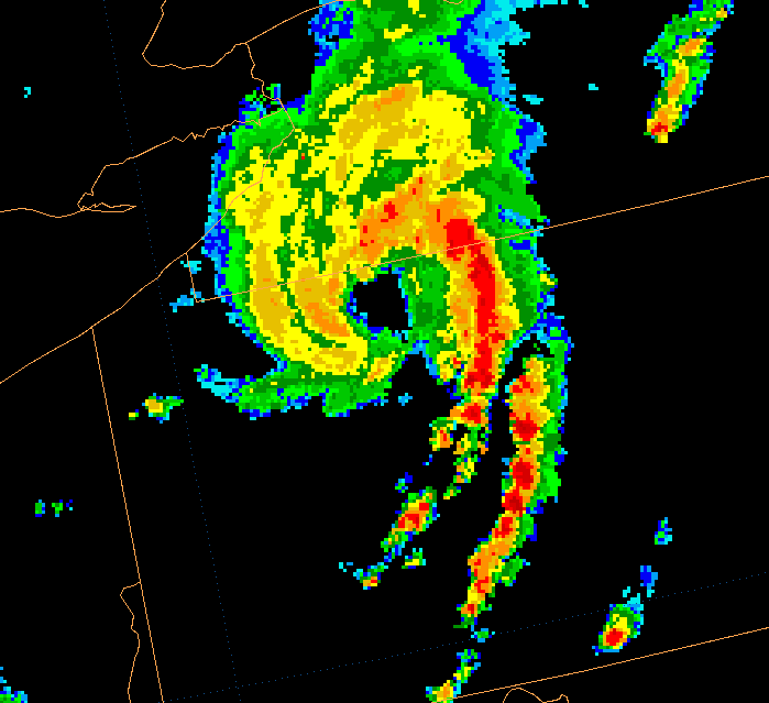
Severe weather indicators
Squall lines typically bow out due to the formation of a mesoscale high pressure system which forms within the stratiform rain area behind the initial line. This high pressure areaHigh pressure area
A high-pressure area is a region where the atmospheric pressure at the surface of the planet is greater than its surrounding environment. Winds within high-pressure areas flow outward due to the higher density air near their center and friction with land...
is formed due to strong descending motion behind the squall line, and could come in the form of a downburst
Downburst
A downburst is created by an area of significantly rain-cooled air that, after reaching ground level, spreads out in all directions producing strong winds. Unlike winds in a tornado, winds in a downburst are directed outwards from the point where it hits land or water...
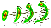
. The pressure difference between the mesoscale high and the lower pressures along the squall line cause high winds, which are strongest where the line is most bowed out. Another indication of the presence of severe weather along a squall line is its morphing into a line echo wave pattern, or LEWP. A LEWP is a special configuration in a line of convective storms that indicates the presence of a low pressure area and the possibility of damaging winds, large hail, and tornadoes. At each kink along the LEWP is a mesoscale low pressure area, which could contain a tornado. In response to very strong outflow southwest of the mesoscale low, a portion of the line bulges outward forming a bow echo. Behind this bulge lies the mesoscale high pressure area.
Polar low
Derecho
A derecho (from Spanish: "derecho" meaning "straight") is a widespread and long-lived, violent convectively induced straight-line windstorm that is associated with a fast-moving band of severe thunderstorms usually taking the form of a bow echoBow echo
A bow echo is a term describing the characteristic radar return from a mesoscale convective system that is shaped like an archer’s bow. These systems can produce severe straight-line winds and occasionally tornadoes, causing major damage.-Research:...
. Derechos blow in the direction of movement of their associated storms, similar to a gust front
Outflow boundary
An outflow boundary, also known as a gust front, is a storm-scale or mesoscale boundary separating thunderstorm-cooled air from the surrounding air; similar in effect to a cold front, with passage marked by a wind shift and usually a drop in temperature and a related pressure jump...
, except that the wind is sustained and generally increases in strength behind the "gust" front. A warm weather phenomenon, derechos occur mostly in summer, between May and August in the Northern hemisphere
Northern Hemisphere
The Northern Hemisphere is the half of a planet that is north of its equator—the word hemisphere literally means “half sphere”. It is also that half of the celestial sphere north of the celestial equator...
. They can occur at any time of the year and occur as frequently at night as in the daylight hours.
The traditional criteria that distinguish a derecho from a severe thunderstorm are sustained winds of 58 miles per hour (93.3 km/h) during the storm as opposed to gusts, high or rapidly increasing forward speed, and geographic extent (typically 250 nautical miles (463 km) in length.) In addition, they have a distinctive appearance on radar (bow echo); several unique features, such as the rear inflow notch and bookend vortex, and usually manifest two or more downbursts. Although these storms most commonly occur in North America
North America
North America is a continent wholly within the Northern Hemisphere and almost wholly within the Western Hemisphere. It is also considered a northern subcontinent of the Americas...
, derechos occur elsewhere in the world. Outside North America they may be called by different names. For example, in Bangladesh
Bangladesh
Bangladesh , officially the People's Republic of Bangladesh is a sovereign state located in South Asia. It is bordered by India on all sides except for a small border with Burma to the far southeast and by the Bay of Bengal to the south...
and adjacent portions of India
India
India , officially the Republic of India , is a country in South Asia. It is the seventh-largest country by geographical area, the second-most populous country with over 1.2 billion people, and the most populous democracy in the world...
, a type of storm known as a "Nor'wester
Nor'wester
Nor'wester has been used to describe sumeet several different types of wind.*A New Zealand wind pattern resulting in the Nor'west arch and leading to hot, dry weather on the east coast of the South Island....
" may be a progressive derecho.
See also
- Convective storm detectionConvective storm detectionConvective storm detection is the meteorological observation of deep, moist convection and consists of detection, monitoring, and short-term prediction. This term includes the minority of storms which do not produce lightning and thunder. Convective storms can produce tornadoes as well as large...
- Mesoscale convective systemMesoscale Convective SystemA mesoscale convective system is a complex of thunderstorms that becomes organized on a scale larger than the individual thunderstorms but smaller than extratropical cyclones, and normally persists for several hours or more...
- SquallSquallA squall is a sudden, sharp increase in wind speed which is usually associated with active weather, such as rain showers, thunderstorms, or heavy snow. Squalls refer to an increase in the sustained winds over a short time interval, as there may be higher gusts during a squall event...
- Surface weather analysisSurface weather analysisSurface weather analysis is a special type of weather map that provides a view of weather elements over a geographical area at a specified time based on information from ground-based weather stations...