

Protohistory of West Virginia
Encyclopedia
Protohistory
Protohistory refers to a period between prehistory and history, during which a culture or civilization has not yet developed writing, but other cultures have already noted its existence in their own writings...
period of the US state of West Virginia
West Virginia
West Virginia is a state in the Appalachian and Southeastern regions of the United States, bordered by Virginia to the southeast, Kentucky to the southwest, Ohio to the northwest, Pennsylvania to the northeast and Maryland to the east...
begins in the mid 16th century with the arrival of European trade goods originating with explorers and colonists on the eastern and southern coasts and being brought inland by native trade routes. This was a period of increased intertribal strife, with rapid population decline, the abandonment of traditional lifeways and the extinction and/or migrations of many Native American groups. By the late 17th to early 18th century actual written accounts of the area begin, with the scattered documentation and journals of early explorers of the region. These accounts frequently portray a sparsely inhabited area, possibly due to the Iroquois
Iroquois
The Iroquois , also known as the Haudenosaunee or the "People of the Longhouse", are an association of several tribes of indigenous people of North America...
wars to monopolize the European fur trade or the devastating effects of new diseases introduced by Europeans.
Archaeological cultures
During the climatic upswing of the Medieval Warm PeriodMedieval Warm Period
The Medieval Warm Period , Medieval Climate Optimum, or Medieval Climatic Anomaly was a time of warm climate in the North Atlantic region, that may also have been related to other climate events around the world during that time, including in China, New Zealand, and other countries lasting from...
(900–1200 CE) the introduction of the bow and arrow and maize led many Late Woodland period groups in Eastern and Southern North America to develop sedentary agriculture based societies and produce larger populations. With the advent of the Little Ice Age
Little Ice Age
The Little Ice Age was a period of cooling that occurred after the Medieval Warm Period . While not a true ice age, the term was introduced into the scientific literature by François E. Matthes in 1939...
(16th to the 19th century), and the adverse weather conditions it brought such as drought and colder winters, these groups began to experience severe social stress as they competed for scarcer resources such as timber, fertile farm land and game animals. When the Europeans with their technologically advanced weapons and devastating diseases arrived in the 16th century, these already unstable and severely stressed societies had already been experiencing rising intergroup warfare. Many of these groups are now only known through the archaeological record.
Fort Ancient and Monongahela
In the western part of the state (and the adjoining states of Pennsylvania, Maryland, Ohio and Kentucky) along the Ohio RiverOhio River
The Ohio River is the largest tributary, by volume, of the Mississippi River. At the confluence, the Ohio is even bigger than the Mississippi and, thus, is hydrologically the main stream of the whole river system, including the Allegheny River further upstream...
and its tributaries lived groups now known as the Fort Ancient
Fort Ancient
Fort Ancient is a name for a Native American culture that flourished from 1000-1750 CE among a people who predominantly inhabited land along the Ohio River in areas of modern-day Southern Ohio, Northern Kentucky, Southeastern Indiana and Western West Virginia. They were a maize based agricultural...
and Monongahela cultures. Late Fort Ancient (1400 to 1750) and Late Monongahela (1580 to 1635) peoples during this time began consolidating their villages into larger settlements with more defensive measures such as wooden palisade
Palisade
A palisade is a steel or wooden fence or wall of variable height, usually used as a defensive structure.- Typical construction :Typical construction consisted of small or mid sized tree trunks aligned vertically, with no spacing in between. The trunks were sharpened or pointed at the top, and were...
s. Archaeologists suggest that this means that intergroup strife had increased, with the smaller settlements amalgamating into larger entities for mutual protection. The peoples of these two very similar cultures were in contact with and influenced by Mississippian culture
Mississippian culture
The Mississippian culture was a mound-building Native American culture that flourished in what is now the Midwestern, Eastern, and Southeastern United States from approximately 800 CE to 1500 CE, varying regionally....
s to their south and west. Exotic trade items from these Mississippian regions are frequently found in excavated Fort Ancient and Monongahela villages. These items, such as shell gorget
Shell gorget
A shell gorget is a Native American art form of polished, carved shell pendants worn around the neck. The gorgets are frequently engraved, and are sometimes highlighted with pigments, or fenestrated ....
s from Eastern Tennessee, a head pot similar to those produced in the Central Mississippi Valley by the peoples of the Middle Mississippian Parkin and Nodena Phase
Nodena Phase
The Nodena Phase is an archaeological phase in eastern Arkansas and southeastern Missouri of the Late Mississippian culture which dates from about 1400–1650 CE. The Nodena Phase is known from a collection of villages along the Mississippi River between the Missouri Bootheel and Wapanocca Lake...
s, and pottery with motifs and decoration methods connected with Angel Phase
Angel Phase
The Angel Phase describes a 300-400-year cultural manifestation of the Mississippian culture of the central portions of the United States of America, as defined in the discipline of archaeology. Angel Phase archaeological sites date from c...
sites in the Lower Ohio Valley, made their way into this region through long established native trade routes. By the early 1600s articles of European manufacture also begin being deposited in the archaeological record at sites such as Lower Shawneetown and Hardin Village
Hardin Village Site
The Hardin Village Site is a Fort Ancient culture Montour Phase archaeological site located on a terrace of the Ohio River near South Shore in Greenup County, Kentucky. It is located within the Big Sandy Management Area along with the nearby Lower Shawneetown site. The site was first inhabited...
in nearby Greenup County, Kentucky
Greenup County, Kentucky
Greenup County is a county located in the U.S. state of Kentucky. It was formed in 1804. As of 2000, the population was 36,891. Its county seat is Greenup. The county is named in honor of Christopher Greenup....
and the Buffalo
Buffalo Indian Village Site
The Buffalo archeological site is located nearby Buffalo, Putnam County, West Virginia along the Kanawha River in the USA. The location is a multi-component site having Archaic village , one Middle Woodland village , and at least two overlapping Fort Ancient villages...
, Rolf Lee and Clover Site
Clover Site
The Clover Site is a Fort Ancient culture archeological site located near Lesage in Cabell County, West Virginia, United States. It is significant for its well-preserved remains of a late prehistoric/protohistoric Native American village. The sites unique assemblage has made it the type site for...
s in Putnam
Putnam County, West Virginia
As of the census of 2000, there were 51,589 people, 20,028 households, and 15,281 families residing in the county. The population density was 149 people per square mile . There were 21,621 housing units at an average density of 62 per square mile...
, Mason
Mason County, West Virginia
As of the census of 2000, there were 25,957 people, 10,587 households, and 7,569 families residing in the county. The population density was 60 people per square mile . There were 12,056 housing units at an average density of 28 per square mile...
and Cabell
Cabell County, West Virginia
As of the census of 2000, there were 96,784 people, 41,180 households, and 25,490 families residing in the county. The population density was 344 people per square mile . There were 45,615 housing units at an average density of 162 per square mile...
Countys in West Virginia, which have all produced European metal objects dated after 1550. These objects would have come from the Spanish, French and English explorers then beginning to explore the eastern seaboard and Gulf Coast of the present United States. One such expedition was the de Soto Entrada of the early 1540s. This expedition spent almost four years trekking from Florida up to the eastern Tennessee region, down through Alabama and across Mississippi to Eastern Arkansas and from there through Northern Louisiana and into Texas before doubling back to Arkansas and down the Mississippi to Mexico by way of the Gulf of Mexico
Gulf of Mexico
The Gulf of Mexico is a partially landlocked ocean basin largely surrounded by the North American continent and the island of Cuba. It is bounded on the northeast, north and northwest by the Gulf Coast of the United States, on the southwest and south by Mexico, and on the southeast by Cuba. In...
. This expedition encountered many Late Mississippian groups and left a trail of European made goods in its wake. By the time of actual European presence in the state of West Virginia these cultures were no longer there, either becoming victims of European diseases which at times had as much as a 90% death rate among Native American populations or migrating to other areas to avoid intergroup warfare such as the Iroquois
Iroquois
The Iroquois , also known as the Haudenosaunee or the "People of the Longhouse", are an association of several tribes of indigenous people of North America...
wars to control the fur trade
North American Fur Trade
The North American fur trade was the industry and activities related to the acquisition, exchange, and sale of animal furs in the North American continent. Indigenous peoples of different regions traded among themselves in the Pre-Columbian Era, but Europeans participated in the trade beginning...
. Several historic period tribes have been proposed as their descendants, including the Shawnee
Shawnee
The Shawnee, Shaawanwaki, Shaawanooki and Shaawanowi lenaweeki, are an Algonquian-speaking people native to North America. Historically they inhabited the areas of Ohio, Virginia, West Virginia, Western Maryland, Kentucky, Indiana, and Pennsylvania...
, Kanawha River Moneton, Honniasont
Honniasont
The Honniasont were a little-known indigenous people of North America originally from eastern Ohio, western Pennsylvania and West Virginia. They appear to have inhabited the upper Ohio River valley, above Louisville, Kentucky .-Language:Honniasont may have been considered an Iroquoian language...
and the Black Minqua, although no definite identifications have yet been made.
Earliest historic periods
St. Lawrence Iroquoians
The St. Lawrence Iroquoians were a prehistoric First Nations/Native American indigenous people who lived from the 14th century until about 1580 CE along the shores of the St. Lawrence River in present-day Quebec and Ontario, Canada, and New York State, United States. They spoke Laurentian...
(Laurentian
Laurentian language
Laurentian, or St. Lawrence Iroquoian, was an Iroquoian language spoken until the late 16th century along the shores of the Saint Lawrence River in present-day Quebec and Ontario, Canada. It is believed to have disappeared with the extinction of the St...
). Pendergast, James F (Journal of Canadian Studies, Winter 1998) writes, "...the Hochelagans and Stadaconans were the earliest of all the Iroquoians to encounter Europeans." Laurentian were neither Huron nor Iroquois League elements. Quoting Darren Bonaparte, Mohawk
Mohawk nation
Mohawk are the most easterly tribe of the Iroquois confederation. They call themselves Kanien'gehaga, people of the place of the flint...
community of Ahkwesáhsne
Akwesasne
The Mohawk Nation of Akwesasne is a Mohawk Nation territory that straddles the intersection of international and provincial borders on both banks of the Saint Lawrence River. Most of the land is in what is otherwise the United States...
on the St. Lawrence River, 2009, "Oral traditions of the Iroquois
Iroquois
The Iroquois , also known as the Haudenosaunee or the "People of the Longhouse", are an association of several tribes of indigenous people of North America...
confirm that our ancient ancestors were once part of a single group that migrated this way from the Ohio River
Ohio River
The Ohio River is the largest tributary, by volume, of the Mississippi River. At the confluence, the Ohio is even bigger than the Mississippi and, thus, is hydrologically the main stream of the whole river system, including the Allegheny River further upstream...
Valley before encountering an Algonquain
Algonquian peoples
The Algonquian are one of the most populous and widespread North American native language groups, with tribes originally numbering in the hundreds. Today hundreds of thousands of individuals identify with various Algonquian peoples...
people on the upper St. Lawrence that forced them to find refuge south and southeast of Lake Ontario
Lake Ontario
Lake Ontario is one of the five Great Lakes of North America. It is bounded on the north and southwest by the Canadian province of Ontario, and on the south by the American state of New York. Ontario, Canada's most populous province, was named for the lake. In the Wyandot language, ontarío means...
." By the 14th century, a distinct St. Lawrence Iroquoian culture had created fortified villages (Pendergast 1998) and introduced corn to the St. Lawrence valley. "St. Lawrence Iroquoian women had an “artistic signature” that is easily recognizable in the decorations on these vessels, bearing incised, corn ear and ladder-like motifs", according to Pointe-à-Callière, the Montréal Museum of Archaeology and History
Pointe-à-Callière Museum
Pointe-à-Callière Museum is the Montreal museum of archaeology and history located in Old Montreal, Quebec, Canada. It was founded in 1992 as part of celebrations to mark Montreal's 350th birthday...
. A matrilineal society, several families of girls and brothers from the same maternal lineage shared a longhouse. A married man moved into his wife's longhouse. Scholars suspect Laurentian included a few subdivisions, elemental or clans. In the southwest area of this region, the Neutral practiced deer husbandry by the end of the Laurentian's era (Noble 1994).
As within the Mountain State, Canadien archeological and linguistic studies have progressed since those done in the 1950s. The Five Nation Iroquois League are the result of essentially parallel contemporary in situ developments to Laurentian (Pendergast 1998). French explorer Jacques Cartier
Jacques Cartier
Jacques Cartier was a French explorer of Breton origin who claimed what is now Canada for France. He was the first European to describe and map the Gulf of Saint Lawrence and the shores of the Saint Lawrence River, which he named "The Country of Canadas", after the Iroquois names for the two big...
in 1535–1536 recorded his visit with the Laurentian at Stadacona, near present-day Quebec City
Quebec City
Quebec , also Québec, Quebec City or Québec City is the capital of the Canadian province of Quebec and is located within the Capitale-Nationale region. It is the second most populous city in Quebec after Montreal, which is about to the southwest...
, and Hochelaga on the Island of Montreal
Montreal
Montreal is a city in Canada. It is the largest city in the province of Quebec, the second-largest city in Canada and the seventh largest in North America...
. These palisaded villages had disappeared before the 1604–1607 exploration of Samuel de Champlain
Samuel de Champlain
Samuel de Champlain , "The Father of New France", was a French navigator, cartographer, draughtsman, soldier, explorer, geographer, ethnologist, diplomat, and chronicler. He founded New France and Quebec City on July 3, 1608....
(Bonaparte). He found Kanienkehaka (Mohawk) hunting and passing along the St. Lawrence valley who were another variant Iroquois group. Their Iroquois Confederacy of upstate New York origination date has been estimated from 1390 (Parker) to 1450 (Wallace) while others extend the forming to AD 1000–1100. Isaac J. Emrick writes in 2005 of Indian generalizations in the Mountain State, "In the seventeenth century, Native Americans had not yet formed the large political “tribes” known during the 18th and 19th centuries. Therefore, tribal names used in historical literature for later periods are inappropriate for the 17th century. The pitfalls of using 18th century terms are twofold. No recognizable 'tribal' groups were in the region when settlers came, so it was assumed that the land was unoccupied. Second, the subtleties of Indian language were poorly understood by contemporary Europeans. Historical literature is full of vague references to Indian names." West Virginia saw no large centralized sovereign national governments of Native American
Indigenous peoples of the Americas
The indigenous peoples of the Americas are the pre-Columbian inhabitants of North and South America, their descendants and other ethnic groups who are identified with those peoples. Indigenous peoples are known in Canada as Aboriginal peoples, and in the United States as Native Americans...
. Smaller family groups of various phratries, who did not migrate away, slowly blended with new arrivals as happens today for ethnicities in the state.
Iroquoians spread northward to as far as New York and Ontario
Ontario
Ontario is a province of Canada, located in east-central Canada. It is Canada's most populous province and second largest in total area. It is home to the nation's most populous city, Toronto, and the nation's capital, Ottawa....
beginning AD 600. This was during the height of indigenous Watson complex dominate Z-twist pottery and S-twist pottery in the state, and resultant significant amounts of net-impressed and corncob tool finished pottery appearance. The latter also found in south-western Virginia Siouan. The Encyclopedia of American History declares they were horticulturalists attracted by improved climatic conditions. Quoting the US History Encyclopedia, "The expansion also cut off the Eastern Algonquian-speaking peoples of the Northeast from the Central Algonquians of the Great Lakes basin." To quote Richard L. George of the Pennsylvania Archaeology Society, "I believe that some of the Monongahela were of Algonquin origin... Other scholars have suggested that Iroquoian speakers were interacting with Late Monongahela people, and additional evidence is presented to confirm this. I conclude that the archaeologically conceived term, Monongahela, likely encompasses speakers of several languages, including Siouan." Many areas or super cities in the United States, today, are also multilingual however from societies around the globe, some acculturating for International Trade
International trade
International trade is the exchange of capital, goods, and services across international borders or territories. In most countries, such trade represents a significant share of gross domestic product...
(Organization of American State's Foreign Trade Information System) and others soon assimilating (Diner 2008). People have seemingly always moved about and mingled for various reasons, hostile or not.
Early reports
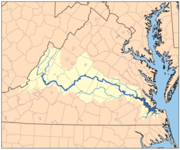
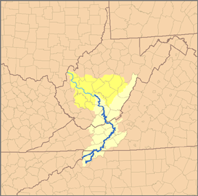
Greenbrier River
The Greenbrier River is a tributary of the New River, long, in southeastern West Virginia, USA. Via the New, Kanawha and Ohio Rivers, it is part of the watershed of the Mississippi River, draining an area of...
or Gauley River
Gauley River
The Gauley River is a river in West Virginia. It merges with the New River to form the Kanawha River, a tributary of the Ohio River. It is one of the most popular advanced whitewater runs in the Eastern United States and is the chief feature of the Gauley River National Recreation Area.-Headwaters...
valleys. The reason he did not bother to investigate is not given. A Mohetan runner met the Virginian and Siouan group to discover whether they were planning to attack or not, and was given ammunition for his European gun. This was prior to Bacon's Rebellion
Bacon's Rebellion
Bacon's Rebellion was an uprising in 1676 in the Virginia Colony in North America, led by a 29-year-old planter, Nathaniel Bacon.About a thousand Virginians rose because they resented Virginia Governor William Berkeley's friendly policies towards the Native Americans...
, the Virginian farmers uprising against their locale tribes in 1676 and when by 1653 the New York Iroquois League destroyed the Neutral Nation
Neutral Nation
The Neutrals, also known as the Attawandaron, were an Iroquoian nation of North American native people who lived near the shores of Lake Ontario and Lake Erie.-Territory:...
's trade network found later within this text.*
Canaragay
The Canaragay lived near the northerly New River (Kanawha River) watershed region in north-western North CarolinaNorth Carolina
North Carolina is a state located in the southeastern United States. The state borders South Carolina and Georgia to the south, Tennessee to the west and Virginia to the north. North Carolina contains 100 counties. Its capital is Raleigh, and its largest city is Charlotte...
area. This southern Appalachian Mountain chain or Mountain range
Mountain range
A mountain range is a single, large mass consisting of a succession of mountains or narrowly spaced mountain ridges, with or without peaks, closely related in position, direction, formation, and age; a component part of a mountain system or of a mountain chain...
divide heads a number of rivers that drain directly to the Gulf of Mexico
Gulf of Mexico
The Gulf of Mexico is a partially landlocked ocean basin largely surrounded by the North American continent and the island of Cuba. It is bounded on the northeast, north and northwest by the Gulf Coast of the United States, on the southwest and south by Mexico, and on the southeast by Cuba. In...
, directly to the Atlantic Ocean and the Ohio Valley thence to the Mississippi River
Mississippi River
The Mississippi River is the largest river system in North America. Flowing entirely in the United States, this river rises in western Minnesota and meanders slowly southwards for to the Mississippi River Delta at the Gulf of Mexico. With its many tributaries, the Mississippi's watershed drains...
which drains to the Gulf of Mexico
Gulf of Mexico
The Gulf of Mexico is a partially landlocked ocean basin largely surrounded by the North American continent and the island of Cuba. It is bounded on the northeast, north and northwest by the Gulf Coast of the United States, on the southwest and south by Mexico, and on the southeast by Cuba. In...
, geography. The west slope of the divide has the Holston River
Holston River
The Holston River is a major river system of southwestern Virginia and east Tennessee. The three major forks of the Holston rise in southwestern Virginia and have their confluence near Kingsport, Tennessee. The North Fork flows southwest from Sharon Springs in Bland County, Virginia...
. This area is now part of the Kingsport–Bristol (TN)–Bristol (VA) Metropolitan Statistical Area. John Lederer
John Lederer
John Lederer was a 17th-century German physician and an explorer of the Appalachian Mountains. He and the members of his party became the first Europeans to crest the Blue Ridge Mountains and the first to see the Shenandoah Valley and the Allegheny Mountains beyond...
, on behalf of the colonial governor of Virginia, Sir William Berkeley, made expeditions into the Appalachians in 1669 and 1670 reaching the mouth of the Kanawha River.He reported no hostilities on the Kanawha Valley from the early "Cherokee People". He settled in western Maryland and made trips to the head waters of the Potomac area. The Iroquoian stock of the Virginias, Nottoway or Mangoac and allied Meherrin and remnant Susquehanna, called themselves, Chiroenhaka according to James Mooney. In the north this linguistic grouping was called Mingo or Mengwe by the Dutch
Dutch people
The Dutch people are an ethnic group native to the Netherlands. They share a common culture and speak the Dutch language. Dutch people and their descendants are found in migrant communities worldwide, notably in Suriname, Chile, Brazil, Canada, Australia, South Africa, New Zealand, and the United...
trade or New England Algonquian
Algonquian peoples
The Algonquian are one of the most populous and widespread North American native language groups, with tribes originally numbering in the hundreds. Today hundreds of thousands of individuals identify with various Algonquian peoples...
stock (Mooney 1894:7–8). Paula W. Wallace writes, "In 1669 Iroquois Indians warned the French that if they tried to descend the Ohio River they would be in danger from the "Andastes." (Susquesahanocks: Wallace 1961:13). John Lederer's guide was a Susquehanna on his journey to the south west Virginia and North Carolina of the Early Cherokee people (Mooney 1894:32).
Ocanahonon
Ocanahonon, reported by the Powhatan to Smith in 1607, were dressed like Europeans and carried curved swords at a village ten days west beyond the mountains. Smith writes from the James RiverJames River
The James River may refer to:Rivers in the United States and their namesakes* James River * James River , North Dakota, South Dakota* James River * James River * James River...
of the reported village location, "which seemed to be a mightie River, issuing from mightie Mountains betwixt the two seas, the people cloathed at Ocamahowan" (Pendergast 1991:76). In 1622 Edward Waterhouse found warrant to mention a party of a half dozen Englishmen deserters joining Spanish to be west of Virginia. From this report, several scholars found several possible locations five days south of Jamestown. Pendergast closes his chapter, writing, "Quinn (1973: 459; 1985: 371) has suggested that the Europeans at Ocamahowan (sic) may be either the French on the St. Lawrence River or a village on the Roanoke River
Roanoke River
The Roanoke River is a river in southern Virginia and northeastern North Carolina in the United States, 410 mi long. A major river of the southeastern United States, it drains a largely rural area of the coastal plain from the eastern edge of the Appalachian Mountains southeast across the Piedmont...
" (Pendergast 1991:78). None of these scholars mention peculiarities found at local sites, such as Bentley 15Bd11 having both gun and knife parts excavated, between the Great Lakes
Great Lakes
The Great Lakes are a collection of freshwater lakes located in northeastern North America, on the Canada – United States border. Consisting of Lakes Superior, Michigan, Huron, Erie, and Ontario, they form the largest group of freshwater lakes on Earth by total surface, coming in second by volume...
and Gulf of Mexico
Gulf of Mexico
The Gulf of Mexico is a partially landlocked ocean basin largely surrounded by the North American continent and the island of Cuba. It is bounded on the northeast, north and northwest by the Gulf Coast of the United States, on the southwest and south by Mexico, and on the southeast by Cuba. In...
on the Ohio Valley. About 10–13 day's hike from Jamestown
Jamestown, Virginia
Jamestown was a settlement in the Colony of Virginia. Established by the Virginia Company of London as "James Fort" on May 14, 1607 , it was the first permanent English settlement in what is now the United States, following several earlier failed attempts, including the Lost Colony of Roanoke...
, Snidow village's (46MC1 multi-component site 1600–1650 Fuerst 2003; 1650–1690 Jones 1987) at Kegley
Kegley, West Virginia
Kegley is an unincorporated community in Mercer County, West Virginia, United States. Kegley is located along U.S. Route 19 northwest of Princeton. Kegley has a post office with ZIP code 24731....
(Bluestone River
Bluestone River
The Bluestone River is a tributary of the New River, 77 mi long, in southwestern Virginia and southern West Virginia in the United States. Via the New, Kanawha and Ohio Rivers, it is part of the watershed of the Mississippi River...
), nearby river "issuing from mightie Mountains" is of Mohetan region on the New River found to have weapons from an unidentified source. However, the trade ware found there and the greater area of "Riviere de la Ronceverte" is scientifically accepted to be of inter-tribal trade to contact areas. The James, Holston, Big Sandy, Shenandoah, Greenbrier, and Kanawha rivers leads to this general area of mountains range divide.
Rickohockans

Algonquian languages
The Algonquian languages also Algonkian) are a subfamily of Native American languages which includes most of the languages in the Algic language family. The name of the Algonquian language family is distinguished from the orthographically similar Algonquin dialect of the Ojibwe language, which is a...
phrase referred to "from beyond the mountains." Mooney identified them as ancient Cherokee and Parkman has them as a Cat Nation division called Rique. Thwaites regards them as "Riquehronnons" or "Rigueronnons".
These early Iroquois or proto-Iroquoians were from an unspecified region south of the Huronian of today's Canadien region south of Lake Erie
Lake Erie
Lake Erie is the fourth largest lake of the five Great Lakes in North America, and the tenth largest globally. It is the southernmost, shallowest, and smallest by volume of the Great Lakes and therefore also has the shortest average water residence time. It is bounded on the north by the...
of an earlier Neutralia trade network (Noble 1994*). The Iroquois League, by 1653, had destroyed the Neutral Nation
Neutral Nation
The Neutrals, also known as the Attawandaron, were an Iroquoian nation of North American native people who lived near the shores of Lake Ontario and Lake Erie.-Territory:...
's trade network. As mentioned, the Rickohockans arrived in Virginia soon after this. Alvord and Bidgood (1912) writes, "Through misunderstanding and mismanagement they (Rickohockans) were attacked, and inflicted a severe defeat upon Colonel Edward Hill and the friendly Pamunkey
Pamunkey
The Pamunkey nation are one of eleven Virginia Indian tribes recognized by the Commonwealth of Virginia. The historical tribe was part of the Powhatan paramountcy, made up of Algonquian-speaking tribes. The Powhatan paramount chiefdom was made up over 30 tribes, estimated to total about...
s, at the forks of the river of that name." Alvord and Bidgood (1912) found record in the 'Winder Papers' they retired behind the Blueridge Mountains. James Mooney guessed the Siouan Mahock and Nahyssan (Tutelo) of western Virginia assisted the 'Rechahecrian' invasion of 1656. More recently, Smith (1987:131–32) concluded these Erie became Westo in the south. Worth (1995:17) and Bowne (2006) supports Smith’s hypothesis. Although both peoples, the Rickahockans and later Westo, were characterized as very aggressive and warring, they were thought to be expelled from Lake Erie
Lake Erie
Lake Erie is the fourth largest lake of the five Great Lakes in North America, and the tenth largest globally. It is the southernmost, shallowest, and smallest by volume of the Great Lakes and therefore also has the shortest average water residence time. It is bounded on the north by the...
by the Iroquois League leaving an estimated 700–900 warriors to arrive in the early Virginia colonial trade area.
Tomahitans
Tomahitans are today considered Yuchi by some scholars. Other scholars and earlier historians considered them an ancient Cherokee from eastern Tennessee (Davis 1990:31). Although, scholars consider Yuchi had resided in the region prior to the arriving Early Cherokee. Both the Hernando de Soto Expedition in 1542 and the Captain Juan Pardo Expedition in 1568 made contact with the ancient Uchi otherwise, Chisca. During the spring of 1567, Hernando Moyano, striking out from Joara, also the Berry Site (31BK22), in western North Carolina, attacked and burned the Chisca village of Maniatique (Saltville, VirginiaSaltville, Virginia
As of the census of 2000, there were 2,204 people, 909 households, and 660 families residing in the town. The population density was 273.7 people per square mile . There were 1,003 housing units at an average density of 124.5 per square mile...
) on the upper Holston River
Holston River
The Holston River is a major river system of southwestern Virginia and east Tennessee. The three major forks of the Holston rise in southwestern Virginia and have their confluence near Kingsport, Tennessee. The North Fork flows southwest from Sharon Springs in Bland County, Virginia...
nearby the New River watershed. Joara
Joara
Joara was a large Native American settlement, a regional chiefdom of the Mississippian culture, located in what is now Burke County, North Carolina. Joara is notable as a significant archaeological and historic site. It was a place of encounter in 1540 between the Mississippian people and the...
Village was either Catawba (tribe)
Catawba (tribe)
The Catawba are a federally recognized tribe of Native Americans, known as the Catawba Indian Nation. They live in the Southeast United States, along the border between North and South Carolina near the city of Rock Hill...
(Beck 2006:abstract) or Siouan Cheraw (tribe)
Cheraw (tribe)
The Cheraw , were a tribe of Siouan-speaking Amerindians first encountered by Hernando De Soto in 1540. The name they called themselves is lost to history but the Cherokee called them Ani-suwa'ii and the Catawba Sara...
(Swanton) and possibly a Cherokee
Cherokee
The Cherokee are a Native American people historically settled in the Southeastern United States . Linguistically, they are part of the Iroquoian language family...
name researches Dr Charles Hudson. Having been pushed to northeastern Florida from the Savannah River
Savannah River
The Savannah River is a major river in the southeastern United States, forming most of the border between the states of South Carolina and Georgia. Two tributaries of the Savannah, the Tugaloo River and the Chattooga River, form the northernmost part of the border...
by the Westo
Westo
The Westo were a Native American tribe encountered in the Southeast by Europeans in the 17th century. They probably spoke an Iroquoian language. The Spanish called these people Chichimeco , and, Virginia colonists may have called the same people Richahecrian...
, beginning in 1675, the Yamasee were regularly recorded by the Spanish of the missionary provinces of Guale (central Georgia coast). It was here of the Savannah
Savannah
Savannah or savanna is a type of grassland.It can also mean:-People:* Savannah King, a Canadian freestyle swimmer* Savannah Outen, a singer who gained popularity on You Tube...
s, according to Cornstalk
Cornstalk
Cornstalk was a prominent leader of the Shawnee nation just prior to the American Revolution. His name, Hokoleskwa, translates loosely into "stalk of corn" in English, and is spelled Colesqua in some accounts...
's oratories, his ancestral Kentucky Shawnee arrived finding similar peoples. This was a few generations before the French invitation to resettle the Eastern Panhandle area (Britannica 1988). The Carolina Algonquians had been living in southern lower lands for nearly six hundred years (Outlaw 1990:85–91). In 1727, a delegation of southern Cherokee
Cherokee
The Cherokee are a Native American people historically settled in the Southeastern United States . Linguistically, they are part of the Iroquoian language family...
, close neighbors of the Muscogee (Creek), visiting Charleston, South Carolina
Charleston, South Carolina
Charleston is the second largest city in the U.S. state of South Carolina. It was made the county seat of Charleston County in 1901 when Charleston County was founded. The city's original name was Charles Towne in 1670, and it moved to its present location from a location on the west bank of the...
referred to the Tomahitans as old enemies of their allies the Yamasee
Yamasee
The Yamasee were a multiethnic confederation of Native Americans that lived in the coastal region of present-day northern coastal Georgia near the Savannah River and later in northeastern Florida.-History:...
(Green 1992, p. 26n) of the Muskogean language. As cited earlier, some Yuchi mingled with Cheskepe while others with Occhenechees, similar to Swanton's Tutelo groups known to ally with the strangers to the Blue Ridge Mountains
Blue Ridge Mountains
The Blue Ridge Mountains are a physiographic province of the larger Appalachian Mountains range. This province consists of northern and southern physiographic regions, which divide near the Roanoke River gap. The mountain range is located in the eastern United States, starting at its southern-most...
— the Rickohockans. The Tomahitan tribe did accept members of certain other tribes to live with them as subordinates as did the Shawnee— Phratry
Phratry
In ancient Greece, a phratry ατρία, "brotherhood", "kinfolk", derived from φρατήρ meaning "brother") was a social division of the Greek tribe...
absorptions.
Occhenechees
Occhenechees (Akenatzy) were the middle men of the Mountain State regional trade. According to James MooneyJames Mooney
James Mooney was an American ethnographer who lived for several years among the Cherokee. He did major studies of Southeastern Indians, as well as those on the Great Plains...
of the Bureau of American Ethnology
Bureau of American Ethnology
The Bureau of American Ethnology was established in 1879 by an act of Congress for the purpose of transferring archives, records and materials relating to the Indians of North America from the Interior Department to the Smithsonian Institution...
(Washington, D.C. 1894:54), the Occaneechi "tribal totem was a serpent." It is unknown with how many language groups this Eastern Siouan people mingled and traded. After a long visit with the Tomahitans, Gabriell Arthur was returning home and made a short stay at the village of Sarah. This was "w[h]ere ye Occhenechees weare" on May 1674. Abraham Wood writes, "when it grew prity late in ye night ye Occhenee began to worke thire plot and made an alaram by an hubbub crying out the towne was besett with in numarable company of strange Indians this puts the towne people into a sodane fright many being betweene sleepeing and wakeing, away rune ye Tomahittans and leave all behind them, and a mongst ye rest was Gabrills two pieces of gold and chaine in an Indian bagge away slipe Gabriell and ye Spanish Indian boy which he brought with him and hide themselves in ye bushes." This Abraham Wood letter does not identify the 'strange Indians'.
Monetons
Monetons traded with Tomahitans of Holston RiverHolston River
The Holston River is a major river system of southwestern Virginia and east Tennessee. The three major forks of the Holston rise in southwestern Virginia and have their confluence near Kingsport, Tennessee. The North Fork flows southwest from Sharon Springs in Bland County, Virginia...
Valley and adjoining lower Blue Ridge Mountains
Blue Ridge Mountains
The Blue Ridge Mountains are a physiographic province of the larger Appalachian Mountains range. This province consists of northern and southern physiographic regions, which divide near the Roanoke River gap. The mountain range is located in the eastern United States, starting at its southern-most...
region. Today, there is a growing consensus that Monetons were Eastern Siouan and possibly a westerly branch of Virginia
Virginia
The Commonwealth of Virginia , is a U.S. state on the Atlantic Coast of the Southern United States. Virginia is nicknamed the "Old Dominion" and sometimes the "Mother of Presidents" after the eight U.S. presidents born there...
Monacan, also known as Manachee, 1669 (Mooney 1894:28). However, this theory is moderated when looking at the archaeology of Eastern Tennessee
Tennessee
Tennessee is a U.S. state located in the Southeastern United States. It has a population of 6,346,105, making it the nation's 17th-largest state by population, and covers , making it the 36th-largest by total land area...
of the Yuchi
Yuchi
For the Chinese surname 尉迟, see Yuchi.The Yuchi, also spelled Euchee and Uchee, are a Native American Indian tribe who traditionally lived in the eastern Tennessee River valley in Tennessee in the 16th century. During the 17th century, they moved south to Alabama, Georgia and South Carolina...
(Cisca) and the late Clover Phase of West Virginia (c. 1550~1650), although the lingua franca or Virginia trade language, Occaneechi, is thought to be their primary language (Rankin 2009, WVAS). Reported by Gabriell Arthur in 1671, this acculturated multi-tribe permitted others to live with them as subordinate Siouan 'Occaneechi' . Abraham Wood in 1674 describes them, "Tomahittans keepe theire haire close cut to ye end an enime may not take an advantage to lay hold of them by it." After the Tomahitans concluded the visit with the Kanawha Valley Monetons, his host agreed to venture their explorer towards the mysterious Ohio River. An unidentified People [Calicua?] on or near the Ohio River took Gabriell Arthur captive. They were reported as traditional enemies to the Tomahitans. 'Gabriell' declared these curious people had no Europe trade metal goods, not knowing the use of guns nor metal knife among them. He gave his metal knife to their chief, telling him how much fur would trade for more items of this nature. In reciprocity as Wood writes, "[and] gave him (Gabriell) Rokahamony for his journey and soe they departed, to be short."
From CE 800 to 900, the latest Woodland hamlet farmers (i.e. Drew Tradition) were experiencing milder weather as these northerly Ohio Valley cereal grass, bean and ground vine field farmers see corn arrive. Just prior to the Woodland II period (1350–1607) of the Virginia border region (Hantman in his 'Monacan Archaeology of the Virginia Interior' , 1993, 2001), according to John Lederer recorded in 1670, the Monacan, or Algonquian called "Mandoag", had been driven by enemies from the northwest into Piedmont James River
James River
The James River may refer to:Rivers in the United States and their namesakes* James River * James River , North Dakota, South Dakota* James River * James River * James River...
region of Virginia, estimated to be about CE 1250. There they found an Hunter-gathering people who did not grow corn. Curiously, the Monacan legend has they taught the Doeg
Doeg (tribe)
The Doeg were a Native American tribe who lived in northern Virginia. They spoke an Algonquian language and may have been a branch of the Nanticoke tribe, historically based on the Eastern Shore of Maryland. The Nanticoke considered the Algonquian Lenape as "grandfathers"...
how to crop farm. The Doeg's language is suspected to be similar to Piscataway
Piscataway language
Piscataway is an extinct Algonquian language formerly spoken by the Piscataway, a dominant chiefdom on the Western Shore of Chesapeake Bay, in present-day Maryland, United States. Piscataway, also known as Conoy , is considered a dialect of Nanticoke.This designation is based on the scant evidence...
or Nanticoke
Nanticoke language
Nanticoke is an extinct Algonquian language formerly spoken in Delaware and Maryland, United States. The same language was spoken by several neighboring tribes, including the Nanticoke, which constituted the paramount chiefdom; the Choptank, the Assateague, and probably also the Piscataway and the...
.
Kanawha Indians
Kanawha canoemen moved trade along the Ohio Valley and its tributaries of the Oniasantkeronons and Siouan while Messawomeake moved trade from these including the Calicua's northerly area of the state across the Allegheny Mountains
Allegheny Mountains
The Allegheny Mountain Range , also spelled Alleghany, Allegany and, informally, the Alleghenies, is part of the vast Appalachian Mountain Range of the eastern United States and Canada...
in the Earliest Historic period, simply expressed. Local Iroquois Kaháwa' is a noun phrase meaning "boat" (canoe). It varies with Iroquois kahôwö' . Chief Cornstalk's Shawnese (Chalahgawtha
Chalahgawtha
Chalahgawtha was the name of one of the five divisions of the Shawnee, a Native American people, during the 18th century, as well as the name of the principal village of the division. The other four divisions were the Mekoche, Kispoko, Pekowi, and Hathawekela...
) word for canoe was locally "Olagashe". Shawano, Hulagî'si punhanwi, the boat is landing (Thomas Dougherty, June 1, 1890 Vinita, Indian Territory, Shawnee). Iroquois (Tuscarora, Mingoe & Canawagh) call the anglicized Kanawha River "Ka(ih)nawáˀkye" meaning "waterway" (transport-way), and "kye" is an augmentive suffix. The ih and variant h, a string of moving water as to a stream, river. kényua' switch-interactive verb meaning to row a boat or more to ferry someone across a stretch of water. The Canawagh (Kanawhas) were last reported as a band in 1774 of the St Albans area (Hanson Journal) and joined other Iroquois (Lewis) while some Kanawhan mixed with Shawnee moving to the Potomac
Potomac River
The Potomac River flows into the Chesapeake Bay, located along the mid-Atlantic coast of the United States. The river is approximately long, with a drainage area of about 14,700 square miles...
near the trade posts according to John Heckewelder (Loskiel) the primary source— Conoys, Ganawese, etc. explains Charles A. Hanna (Vol II, 1911:96, Ganeiens-gaa, Margry, i., 529; ii., 142–43,) using La Salle's letter of August 22, 1681 Fort Saint Louis (Illinois) mentioning "Ohio tribes" for extrapolation.
The proper noun, "Conoy", appears in the following century, referring to an island on the Potomac and relating the Conoy story from the 1790s (Heckewelder 1818). This is a very late singular story by Loskiel not contemporary to the 17th century nor 1876 "Canai" of Rev. William C. Reichel's Kanawhan language. Contemporary Dr Barton doubted the language of Canai as a dialect of Lenape in connection to Nanticokes (Reichel 1876:122 foote note). None of these authors were known to visit the Kanawhan region. Although, John Heckewelder by horse ride from his upstate Ohio
Ohio
Ohio is a Midwestern state in the United States. The 34th largest state by area in the U.S.,it is the 7th‑most populous with over 11.5 million residents, containing several major American cities and seven metropolitan areas with populations of 500,000 or more.The state's capital is Columbus...
mission spent a night at Belpre, Ohio
Belpre, Ohio
Belpre is a city in Washington County, Ohio, United States, along the Ohio River. It is part of the Parkersburg-Marietta-Vienna, WV-OH Metropolitan Statistical Area. The population was 6,441 at the 2010 census....
and the following night at Gallipolis, Ohio
Gallipolis, Ohio
As of the census of 2000, there were 4,180 people, 1,847 households, and 1,004 families residing in the village. The population density was 1,156.2 people per square mile . There were 2,056 housing units at an average density of 568.7 per square mile...
catching a boat to sail west down the Ohio River
Ohio River
The Ohio River is the largest tributary, by volume, of the Mississippi River. At the confluence, the Ohio is even bigger than the Mississippi and, thus, is hydrologically the main stream of the whole river system, including the Allegheny River further upstream...
into Kentucky
Kentucky
The Commonwealth of Kentucky is a state located in the East Central United States of America. As classified by the United States Census Bureau, Kentucky is a Southern state, more specifically in the East South Central region. Kentucky is one of four U.S. states constituted as a commonwealth...
waters the following morning according to his journal.
Paula W. Wallace writes, "In 1669 Iroquois Indians warned the French that if they tried to descend the Ohio River they would be in danger from the Andastes" (Susquesahanocks: Wallace 1961:13). The Maryland Accokeek Creek site (AD 1300–1650) is associated with the historic Piscataway Indians
Piscataway Indian Nation
The Piscataway Indian Nation and Tayac Territory is an unrecognized Native American tribe in Maryland that is related to the historic Piscataway tribe. At the time of European encounter, the Piscataway was one of the most populous and powerful Native polities of the Chesapeake Bay region, with a...
(Kavanagh et al. 2009) There are no archaeological sites of centuries established Piscataway of the lower Potomac Valley in the Ohio Valley nor West Virginia as associated with the c. 1800 Heckewelder story of "Conoy." According to Eugene Scheel, after a long Siouan occupation, in 1699 with some Doeg, the Piscataway moved up to the Conoy Island of the Maryland
Maryland
Maryland is a U.S. state located in the Mid Atlantic region of the United States, bordering Virginia, West Virginia, and the District of Columbia to its south and west; Pennsylvania to its north; and Delaware to its east...
region. Daniel Garrison Brinton
Daniel Garrison Brinton
Daniel Garrison Brinton was an American archaeologist and ethnologist.-Biography:Brinton was born in Thornbury Township, Chester County, Pennsylvania. After graduating from Yale University in 1858, Brinton studied at Jefferson Medical College for two years and spent the next travelling in Europe....
, based on Heckewelder, had earnestly figured kanawha meant “Long River” (Walum Olum
Walam Olum
The Walam Olum or Walum Olum, usually translated as "Red Record" or "Red Score," is purportedly a historical narrative of the Lenape Native American tribe. The document has provoked controversy as to its authenticity since its publication in the 1830s by botanist and antiquarian Constantine Samuel...
pg. 17) knowing the location of 18th century Kanawha-Lenape (Chief Bull phratry). He figured the root word could be Conoy or Ganawese from the term, "Guneu"-this long. Albert S. Gatschet in 1885 researching the language and later at Vinita Indian Territory of the Shawnee in 1890 declared the phrase Kanawha is not Algonquian
Algonquian languages
The Algonquian languages also Algonkian) are a subfamily of Native American languages which includes most of the languages in the Algic language family. The name of the Algonquian language family is distinguished from the orthographically similar Algonquin dialect of the Ojibwe language, which is a...
Shawnee
Shawnee
The Shawnee, Shaawanwaki, Shaawanooki and Shaawanowi lenaweeki, are an Algonquian-speaking people native to North America. Historically they inhabited the areas of Ohio, Virginia, West Virginia, Western Maryland, Kentucky, Indiana, and Pennsylvania...
. The state does have Algonquian phrases, perhaps from protohistoric Ouabano and ancient Telegwa or later mix Makujay
Mekoche
Mekoche was the name of one of the five divisions of the Shawnee, a Native American people, during the 18th century. The other four divisions were the Chalahgawtha, Kispoko, Pekowi, and Hathawekela. Together these divisions formed the loose confederacy that was the Shawnee tribe....
(Draper & Belue 1998:202; Pritchard 2002:274), popularly demarking locations and other streams.
White traders began establishing trading houses on the Ohio, Allegheny, and Monongahela valleys in 1717 according to University of Pittsburgh's 'Historic Pittsburgh'. Pennsylvania fur trader, Michael Bezallion, in this year made a record of his trip from Illinois
Illinois
Illinois is the fifth-most populous state of the United States of America, and is often noted for being a microcosm of the entire country. With Chicago in the northeast, small industrial cities and great agricultural productivity in central and northern Illinois, and natural resources like coal,...
country up the Ohio enroute to Philadelphia. Among other locations, it appears Logstown
Logstown
The riverside village of Logstown was a significant Native American settlement in Western Pennsylvania and the site of the 1752 signing of the treaty of friendship between the Ohio Company and the Amerindians occupying the region in the years leading up to the...
village was reported. The Iroquois established a town at Kanaugha opposite the Mouth of the Kanawha before 1748 (Jacobs 1953; Adair, Atkins Report of 1755) and the French constructed a fort nearby prior to the French and Indian War (Atkinson 1876:21) James (Jacob) Le Tort, Sr. moved his Penn permit (1720s~30s) trading house near Letart Falls from the Allegheny's Beaver Creek area fur trade by 1740. Nearby on August 12, 1749, Céloron de Blainville, a French Canadian officer and his flotilla of canoes, "encountered two canoes, loaded with packs and guided by four Englishmen." Trade artifacts are found at Orchard (46Ms61), Belldina Bottom (46MG75A), Rolfe Lee (46Ms123 period #1), and other early trace of tradeware easterly in the state from the 17th century. It is unknown how early indvidual protohistoric Colonial People were slipping into the Kanawha region trade as Bienville writes, "The English of this government come by treaty to the Belle Rivière."
To note a vary old gathering location or hunter's camp, also village and a mound archaeological site, Hudson's Trading Post Inn and canoe landing eventually appears on Madison's 1807 map opposite St Albans. Here, a Heckewelder visit might have enlighten his question about Kanawhans. "Jonas Davenport, Edmund Cartlidge, and Henry Baly were the first to penetrate as far west as the Alleghany River to trade with the Indians. They were closely followed by Gordon Howard, William Wilkins, John Burt, John Harris, Thomas Harris, David Hendricks, John Galbraith, George Croghan, and Lazarus Lowery, the last of whom first took out a license to trade with the Indians in 1730." quoting Samuel Evans, 'The First Explorers of Kentucky' , J.E. Potter & co., 1875. As seen on some of this period's colonial maps, the upper Ohio River was also viewed as an extension of the Alleghany River along the West Virginia shores. A Delaware Indian legend of ancient time, retold by Heckewelder, finally defeated the Allegheny Indians which allowed them a pass through Alleghenian to arrive on the east coast where becomes their homeland. Similar legend found in the 1988 Britannica article, King Powhatan I fought his way down New York. Migrating in the 16th century colder weather period, they arrived in the friendly Delaware territory. From there, his people moved into the Chespeake Bay region conquering the various small ancient tribes.
Oniasantkeronons
Oniasantkeronons (Hoñniasontke'roñnon, D.B. Ricky 1998) are of either the Kanawha, the Big Sandy, or the Kentucky streams; "probably the Kanawha" because the other two river have recorded Siouan names, the Kanawha does not according to Hanna. The hills or mountains adjoining southerly of the Great Kanawha were once variously called, Waseoto, Osioto, Osiata, Oseoto, and Onosiota (La Posta). Here, the 19th century regional historian G. W. Atkinson writes a chapter on Ancient Fortifications (1876:98). At the mouth of Bull creek on the Coal RiverCoal River (West Virginia)
The Coal River is a tributary of the Kanawha River in southern West Virginia. It is formed near the community of Alum Creek by the confluence of the Big and Little Coal Rivers, and flows generally northward through western Kanawha County, past the community of Upper Falls and into the Kanawha...
, 30 miles up stream of St Albans
St. Albans, West Virginia
St. Albans is a city in Kanawha County, West Virginia, United States, at the confluence of the Kanawha and Coal Rivers. The population was 11,044 at the 2010 census.St. Albans was laid out in 1816...
on the Great Kanawha, a very rare for our region square fort (ruins) was recorded for posterity. Atkinson also relates the description of ruins of a few of the other circular forts on the larger rivers having some fallen, over-growth and rotting, partially exposed posts. Similar northerly trade neighbors, Rhiierrhonons (Erie Jes. Rel. 1635), were scatterd from northern Ohio prior to the famous League (Mohawk) invasion, quoting, "by certain tribes whom we call the Nation of the Cat; they have been compelled to retire far inland to escape their enemies, who are farther to the west," (Jes. Rel. 1647–48, xxxiii, 63, 1898).
Neighboring down river of the Hoñniasontke'roñnon, the 'Shattera' of the Big Sandy Valley
Big Sandy River (Ohio River)
The Big Sandy River is a tributary of the Ohio River, approximately long, in western West Virginia and northeastern Kentucky in the United States. The river forms part of the boundary between the two states along its entire course...
(Toteroy River), migrated easterly toward the Monacan sometime after 1699 near Salem, Virginia
Salem, Virginia
Salem is an independent city in Virginia, USA, bordered by the city of Roanoke to the east but otherwise adjacent to Roanoke County. It is part of the Roanoke Metropolitan Statistical Area. The population was 24,802 according to 2010 U.S. Census...
. There is one destroyed village of Casa near Huntington
Huntington, West Virginia
Huntington is a city in Cabell and Wayne counties in the U.S. state of West Virginia, along the Ohio River. Most of the city is in Cabell County, for which it is the county seat. A small portion of the city, mainly the neighborhood of Westmoreland, is in Wayne County. Its population was 49,138 at...
on Franquelin's 1684 map. Charles Hanna writes, if Casa is not a tribe, it may mean only "cabins destroyed." The earlier phrase name, Osioto for the Scioto River in southern Ohio Allegheny Plateau, is not Shawnee (Gatschet MS. 615 Vol I 1885:19; Thomas Dougherty June 1, 1890 Vinita Shawnee).
The central Ohio Valley "Miami-Potawatomi" dispersed winter hunting pattern seems to span AD 1550–1750 (Carmean 2009; Henderson et al. 1992:269). The Little and Great Miami valleys in western Ohio Till Plains region are named for their memory. Charles A. Hanna writes in 1910, "The Scioto, too, it will be remembered, was known to the Indians of Ohio from the earliest historic period as a Deer River, the name "Scioto" itself being a modified form of Oscanoto, the Wyandot word for "deer."
Hanna points out and continues on page 118, "The reader can decide for himself, therefore, whether or not the Ouasiota Mountains and the Ouasiota country meant to the Indians of the Ohio Valley in the seventeenth century anything more than a district where deer abounded; or whether Ouasiota was synonymous with Oniasont ; and whether both were early names of the Scioto River and of the Indians who lived there."
Cartographer John Wallis, "at his Map-Warehouse" (London 1783), has the Scioto River
Scioto River
The Scioto River is a river in central and southern Ohio more than 231 miles in length. It rises in Auglaize County in west central Ohio, flows through Columbus, Ohio, where it collects its largest tributary, the Olentangy River, and meets the Ohio River at Portsmouth...
demarked as the Sikoder R and the "Lower Shanaois" village noted at its mouth. This late English created map of the newly become The United States is called "The United States of America laid down from the best authorities, agreeable to the Peace of 1783."
Mosopelea, as seen on Franquelin's map of 1684, shows tribal villages of eastern Siouan had been destroyed on the central region Ohio River
Ohio River
The Ohio River is the largest tributary, by volume, of the Mississippi River. At the confluence, the Ohio is even bigger than the Mississippi and, thus, is hydrologically the main stream of the whole river system, including the Allegheny River further upstream...
. Recent comparative study is showing a stronger connection with Mississippi Valley Siouan found in house building method at certain sites south-westerly of the state (Maslowski 2010). Regional scholars are continuing research to clear this cloudy period. On August 5, 1684, the New York Iroqouis were encouraged to take control of the Ohio Valley to establish New York trade from the lower half of the Ohio Valley, the French (Broshar, 1920:232). The first documented Albany Trade began with the 'Vielle of Albany' through 1692–94 expedition. The Virginians for some years before were trading in West Virginia (Wood 1674).
Black Mincquaas', according to Augustin Herrman map (dated 1670, printed 1673), the 'Sussquahana' and 'Sinaicus' Indians went over to their River and destroyed that Nation. This river was considered westerly the tributaries of the Potomac Valley of the Allegheny Mountain region. Van der Donck also described Black Mincquaas, "The beavers are mostly taken far inland, there being few of them near the settlements particularly by the Black Minquas, who are thus named because they wear a black badge on their breast, and not because they are really black." Herrman does not show the actual river neither the villages nor the twelve destroyed villages of Kentarentonga (Many fields Place, Iroquoian. [People, caga, haga. Bruyas]); as it is on Franquelin 1684 map. From their adjoining south, Calicua followingly moves upstream to appear on maps of Monongahela and Cheat valleys region. A "Lizard Cult" and citico gorgets appearance eclipse Calicua area cited earlier in the south-west of the state and apparently does not follow them. (Peterson map 5.1 1996-08:91; Maslowski 1973, 1978a, 1980, 1984a: Cordage Twist and Ethnicity). Dr Edward McMichael states, "There is an often quoted rule in anthropology which is well to bear in mind, that there is no necessary one-to-one correlation of race, language, and culture. This makes even more difficult the archaeologist's task in relating the historic tribes to his prehistoric cultures; and in West Virginia, where early historic data are largely lacking, the job is even more difficult, if not impossible." (McMichael 1968:57).
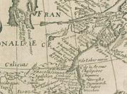
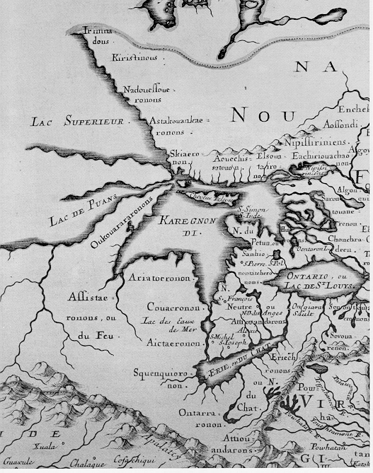
Published in 1898, the 'Proceedings of the American Antiquarian Society' declares Dr. James Smith's map 1720, gives the mitural features correctly; "The Oniasontke or Nation du Chat on the Ohio River; the Tionontatecaga who inhabit in caves to defend themselves from the great heat," of the Iroquois (Hanna's Agnie historical called "Mohawk
Mohawk nation
Mohawk are the most easterly tribe of the Iroquois confederation. They call themselves Kanien'gehaga, people of the place of the flint...
"). This region was also part of a vast proto-historic trade system with connections to the Neutral people prior to 1615–26 contact (Noble 1994). Dr Thomas McElwain (Nov 5, 2000) explains the term, "Black Mingo," as an umbrella term which differentiates the Northern Iroquois region from Southern Iroquois on the northerly or upper of the Ohio Valley, citing Tuck 1978: 29–39. Late Prehistoric tribes he writes, "...from the Neutrals on the north to the Cherokee on the south being within an area of divergent Middle Woodland complexes about which little is known [White 1978: 416]." Here he writes of the archaeological described 'blurred periods' in this region of Watson people (AD 100–800), Montaine (AD 500–1000) and Buck Garden (AD 500–1200) according to Dr McMichael (WVU:1968). From the region of Fort Ancient-influenced Monongahela complex McElwain continues, "However, there is also much evidence for in situ development into Iroquoian cultures [Fitting 1978: 55]." Canal coal pendants are found from the south west Ohio through the Ohio Valley to south western of Pennsylvania
Pennsylvania
The Commonwealth of Pennsylvania is a U.S. state that is located in the Northeastern and Mid-Atlantic regions of the United States. The state borders Delaware and Maryland to the south, West Virginia to the southwest, Ohio to the west, New York and Ontario, Canada, to the north, and New Jersey to...
protohistoric Monongahelan (Johnson 1990, Brose et al 2001:82).
Erie Populi
Erie populi is the earliest recognizable tribal grouping documented including the northerly region "Riviere de la Ronceverte" of the state. The Huron Map of 1642 shows an Allegheny Mountains river delineating the French from Virginian territory (Derek Hayes 2006:58). It is thought Bressani had used maps from 1631, Description du Pais Hurons (plate 35) and following maps to recall his tenure in New France (Heidenreich 1966:115). Francesco Bressani, Novae Franciae accurata delineatio 1657, shows the same river of the French Canadien domain adjoining the Virginia domain below the mountain line. Marcellus Zimmerman wrote in 1756 claiming a large Indian Village was stillstanding where nearby Lewisburg now stands when his Aunt settled here. David Y. Allen, Map Librarian, emeritus, at Stony Brook University, Stony Brook, New York
Stony Brook, New York
Stony Brook is a hamlet located in the Town of Brookhaven in Suffolk County, New York, which is on the North Shore of Long Island...
writes in his abstract, "Iroquois, particularly the Seneca, who had their own ideas about who should be controlling the fur trade with the western Indians... After 1680 the Iroquois attacked Indian allies of the French in the Ohio Valley and even laid siege to Fort Saint Louis." (Allen abstract 2005:5) Found on Allen's page 6, "The long path between the Genesee River
Genesee River
The Genesee River is a North American river flowing northward through the Twin Tiers of Pennsylvania and New York. The river provided the original power for the Rochester area's 19th century mills and still provides hydroelectric power for downtown Rochester....
and Lake Erie
Lake Erie
Lake Erie is the fourth largest lake of the five Great Lakes in North America, and the tenth largest globally. It is the southernmost, shallowest, and smallest by volume of the Great Lakes and therefore also has the shortest average water residence time. It is bounded on the north by the...
is annotated: “Great portage of 30 leagues by which the Senecas travel to war against the Illinois.” Northern Native American were known to take refuge in the state from these raids.
Calicua
Mosopelea
The Mosopelea, or Ofo, were a Native American tribe who historically inhabited the upper Ohio River. In reaction to Iroquois invasions, they moved south to the lower Mississippi River, finally settling in Louisiana and assimilating with the Siouan-speaking Biloxi and the Tunica people...
(Ohio Ofo
Ofo Language
The Ofo language was a language spoken by the Mosopelea tribe who lived until c. 1673 in what is now Ohio along the Ohio River, at which time they moved down the Mississippi River to Mississippi, near the Natchez, and thence to Louisiana, near the Tunica....
) peoples according to the progressing of contemporary maps. Certainly not popular history makers, what Calicuas called themselves is uncertain from little early print. It is unknown when these saw their first gun. As Isaac Emrick (WVU) writes, "The people living in the eastern portion of the Middle Ohio River Valley were not a single political entity throughout the seventeenth century. This poses a functional problem as to what to call these people." Europe's 18th century arrivals apparently had a similar problem finding a name in common of Appalachian regional Indians, those not Shawnee nor Six Nation Iroquois— guessing Cherokee?
Less often however in print, this era is sometimes called a fire-side cabin culture which associates later with 18th century long hunters. Historical Indian-trade Charles Poke's trading post dates from 1731 with these "Trade Indians", then called Cherokee
Cherokee
The Cherokee are a Native American people historically settled in the Southeastern United States . Linguistically, they are part of the Iroquoian language family...
, stemming from this earlier period called "Cherokee Falls"
Valley Falls State Park
Valley Falls State Park is a 1,145 acre day use facility sited along both banks of the Tygart Valley River. The park is located about 7 miles south of exit 137 of I-79, near Fairmont, West Virginia....
. The Calicua were reported on the Tygart Valley River
Tygart Valley River
The Tygart Valley River — also known as the Tygart River — is a principal tributary of the Monongahela River, approximately long, in east-central West Virginia, USA...
and Cheat River
Cheat River
The Cheat River is a tributary of the Monongahela River in eastern West Virginia and southwestern Pennsylvania in the United States. Via the Monongahela and Ohio rivers, it is part of the Mississippi River watershed, ultimately draining into the Gulf of Mexico.-Geography:The Cheat is formed at...
region in 1705 and 1707 of which reports are supported by several contemporary maps (Nicolas de Fer 1715 map). Archaeologically in this area, the Susquehanna site located at Moorefield
Moorefield, West Virginia
Moorefield is a town in Hardy County, West Virginia, USA. Moorefield is the county seat of Hardy County. It was originally chartered in 1777 and named for Conrad Moore, who owned the land upon which the town was laid out...
village Site 46Hy89 (1550–1630), work was stopped and if any connection is not scientifically known. Very far from Cherokee Country, "There was a company of Cherokee Indians in King's pay, being at Fort Lyttleton, and Capt. Hamilton sent some of them to search along the foot of the Allegheny Mountains..." quoting Clarence M. Busch, State Printer Of Pennsylvania, 1896 reconciling old documents. Fort Lyttelton and Fort Shirley were built in 1755–56 by the fur trader and Indian agent George Croghan
George Croghan
George Croghan was an Irish-born Pennsylvania fur trader, Onondaga Council sachem, land speculator, British Indian agent in colonial America and, until accused of treason in 1777, Pittsburgh's president judge and Committee of Safety Chairman keeping the Ohio Indians neutral...
. Christopher Gist
Christopher Gist
Christopher Gist was an accomplished American explorer, surveyor and frontiersman. He was one of the first white explorers of the Ohio Country . He is credited with providing the first detailed description of the Ohio Country to Great Britain and her colonists...
mentions these in his journal and Col Andrew Lewis (soldier)
Andrew Lewis (soldier)
Andrew Lewis was an American pioneer, surveyor, and soldier from Virginia. He served as a colonel of militia during the French and Indian War, and as a brigadier general in the American Revolutionary War...
had an estimated 60 of these Virginia
Virginia
The Commonwealth of Virginia , is a U.S. state on the Atlantic Coast of the Southern United States. Virginia is nicknamed the "Old Dominion" and sometimes the "Mother of Presidents" after the eight U.S. presidents born there...
Cherokee with him on the Big Sandy Expedition in 1756. Several different local reenactors explaining their costume have said these were not quite like Lower Cherokee (Southern Cherokee). 16th century 'Calicvaz', a northerly region on the opposite side of the mountains from Spanish Florida
Spanish Florida
Spanish Florida refers to the Spanish territory of Florida, which formed part of the Captaincy General of Cuba, the Viceroyalty of New Spain, and the Spanish Empire. Originally extending over what is now the southeastern United States, but with no defined boundaries, la Florida was a component of...
, was adjacent the uplands of the southern Appalachian Mountains
Appalachian Mountains
The Appalachian Mountains #Whether the stressed vowel is or ,#Whether the "ch" is pronounced as a fricative or an affricate , and#Whether the final vowel is the monophthong or the diphthong .), often called the Appalachians, are a system of mountains in eastern North America. The Appalachians...
east of Capas Chi, west of Apalchen and north-east of the Coosa of Georgia whom were opposite on the southerly side of mountains or adjacent the uplands (Gutiérrez 1562). There appears to be no sound historical primary documentation of early Spanish visitation into the state.
Spanish and French trade
In the northern of ChickasawChickasaw
The Chickasaw are Native American people originally from the region that would become the Southeastern United States...
country or below the confluence of the Wabash and Ohio area of the Chaouanons, Jolliet and Marquette (1673) met a band of "either Tuscarora or Cherokee— both tribes of Iroquoian origin" (Kellogg 1917:251,252). These people were described as Hiroquois fashion. They were reported as trading with Spanish to an easterly direction and had firearms, also hearing "wild cattle" bellowing nearby on a plains. The French explorers were above the 33rd degree of latitude within the northerly of Spanish trade country. In 1742, John Peter Salley, beginning on the Kanawha River, passed through this region describing the "Ohio Falls" area as a "Spanish Manor". The wild cattle are often assumed to be a smaller extinct Eastern Forest Buffalo
American Bison
The American bison , also commonly known as the American buffalo, is a North American species of bison that once roamed the grasslands of North America in massive herds...
. The last buffalo seen and killed in West Virginia was 1826 in Boone county (Wonderful West Virginia, Brooks 1976:26,27). According to Craig's Olden Time, 1847, Vol II, p. 432, a party of 23 Spaniards ascend the Ohio River
Ohio River
The Ohio River is the largest tributary, by volume, of the Mississippi River. At the confluence, the Ohio is even bigger than the Mississippi and, thus, is hydrologically the main stream of the whole river system, including the Allegheny River further upstream...
from the Mississippi in search of fabled silver. Passing Pittsburgh, they landed their canoes at Olean Point and arrived at Onondaga Lake
Onondaga Lake
Onondaga Lake is a lake in Central New York located northwest of Syracuse, New York. The southeastern end of the lake and the southwestern shore abut industrial areas and expressways; the northeastern shore and northwestern end border a series of parks and museums. Although it is near the Finger...
, New York. There they met unfavorably with the French. The Indians massacred them burning their cabins in 1669 (Collins 1878:14). These had passed along the state river shores enroute.
Above the "Neck of the Potomac", Augustin Herrman
Augustine Herman
Augustine Herman, First Lord of Bohemia Manor was a Bohemian explorer, merchant, and cartographer who lived in New Amsterdam and Cecil County, Maryland...
charted from 1659 to 1670 his published 1673 map which shows the unidentified major branching rivers leading into the Allegheny Mountains. These rivers on the map lead into the easterly valleys of the state to the Greenbrier area divide. His explorer parties evidently did not pass through the gaps of the Monongahela National Forest
Monongahela National Forest
The Monongahela National Forest is a national forest located in the Allegheny Mountains of eastern West Virginia, USA. It protects over of federally-owned land within a proclamation boundary that includes much of the Potomac Highlands Region and portions of 10 counties.The MNF includes some...
. Herrman claimed to know one thing for certain about the mountains, "and whether that same river (Black Minncquaas River) comes out into the bay of Mexico or the West Sea is not known Certain it is that the Spaniard is possessed with great store of Minneralls at the other side of these Mountains".
By 1876, documenting early United States history for the Nation's centennial establishment became a popular subject of historians of the day. George W. Atkinson, M.A. records for posterity the earliest uncovered state relics, writing in 1876, "...proving, conclusively, that over a century and a quarter in the past, the Indians had a populous town on the banks of the "La Belle Riviere". Early settlers while plowing the fields of Old Town Creek bottom near the Mouth of the Kanawha found, at different times, more than 80 gun barrels (Atkinson 1876:19). These settlers also found an anvil, hammers and other evidence of blacksmith ware disturbing now two centuries later archaeological site(s). Long before formal studies, they disinterred from the several mounds on the bottom, tomahawks, "pewter basins," and other odd artifacts which were not recorded in archaeological detail. Today, these scattered reports and relics are viewed precariously by regional scholars.
Teochanontian people were where the Neutral
Neutral Nation
The Neutrals, also known as the Attawandaron, were an Iroquoian nation of North American native people who lived near the shores of Lake Ontario and Lake Erie.-Territory:...
of 800, "in 1653 were forming a league with all the Upper Algonquians" (By Ontario. Legislative Assembly 1908:449). They were south-west of Skenchioe (a Fox village— Flat Country of The Thumb
The Thumb
The Thumb is a region and a peninsula of Michigan, so named because the Lower Peninsula is shaped like a mitten; thus the Thumb is the area that looks like the thumb of the mitten. The Thumb is generally considered to be in the Mid-Michigan area of the state, located east of Flint/Tri-Cities...
, Michigan
Michigan
Michigan is a U.S. state located in the Great Lakes Region of the United States of America. The name Michigan is the French form of the Ojibwa word mishigamaa, meaning "large water" or "large lake"....
Lower Peninsula). Neighboring the Upper Algonquians easterly and scattering from the southern shore of Lake Erie
Lake Erie
Lake Erie is the fourth largest lake of the five Great Lakes in North America, and the tenth largest globally. It is the southernmost, shallowest, and smallest by volume of the Great Lakes and therefore also has the shortest average water residence time. It is bounded on the north by the...
(Jes. Rel. 1647–48, xxxiii, 63, 1898), the Cat Nation
Erie (tribe)
The Erie were an Native American people historically living on the south shore of Lake Erie. An Iroquoian group, they lived in what is now western New York, northwestern Pennsylvania, and northern Ohio...
village, Gentaguetehronnons (Gentaguehronon, Gentaienton), was mentioned in the Relation of 1656 (vol. xlii., p. 197). From the other direction still easterly, kindred Kentaientonga villages were destroyed by Iroquois as they told to the French years afterward (Sultzman, First Nations). These pressured Erie are similar and associated with Honniasont (Black Minqua, Honniasontkeronon, Oniassontke), and Rigué (Arrigahaga, Rigueronnon, Rique, Riquehronnon). At Le Chine in 1669 at Montreal Island (The nation, Vol 56, No. 1456, 1893:384), La Salle was told to expect to find Chaouanon (Algonquian) and Honniasontkeronon (Iroquois) villages on the Ohio above the falls or above Louisville, Kentucky
Louisville, Kentucky
Louisville is the largest city in the U.S. state of Kentucky, and the county seat of Jefferson County. Since 2003, the city's borders have been coterminous with those of the county because of a city-county merger. The city's population at the 2010 census was 741,096...
(Hanna 1911:158). Nothing of the Virginian arrival to contemporary Shattera, Mohetan, Moneton and Calicuas still further upstream in the Mountain State area was mentioned from this 1669 French reference. Exploration, or trade intelligence, was seldom shared between different European nationals and factions (clique often secret, •cabal
Cabal
A cabal is a group of people united in some close design together, usually to promote their private views and/or interests in a church, state, or other community, often by intrigue...
). The Andasté (Chiroenhaka) found on maps as Calicuas territory, or appellent Allegheny area, impeded the New York Haudenosaunee and the French Canadien trade in this region at the time (Mooney 1894, Wallace 1961).
Of the Prairie Algonquians
Central Algonquian languages
The Central Algonquian languages are commonly grouped together as a subgroup of the larger Algonquian family, itself a member of the Algic family. Though this grouping is often encountered in the literature, it is an areal grouping rather than a genetic one...
of the Ohio Valley Confederacy, Evan Pritchard writes (2002) that the Shawnee were made up of many "septs." "These "septs" are the Makujay, the Piqua
Piqua
Piqua may refer to:*Pekowi, a band of the Shawnee Native American tribe and the origin of the word "Piqua"Communities in the United States:*Piqua, Kansas*Piqua, Kentucky*Piqua, OhioOther...
, and the Kispoko
Kispoko
Kispoko is the name of one of the five divisions of the Shawnee, a Native American people that existed during the 18th century. The Kispoko were the smallest of the five divisions. They lived among the Creek as early at 1650, having been driven from their Ohio country homeland by the Iroquois...
/Kispotaka of the Lenni-Lenape root. The Chalgotha/Chillicothe
Chalahgawtha
Chalahgawtha was the name of one of the five divisions of the Shawnee, a Native American people, during the 18th century, as well as the name of the principal village of the division. The other four divisions were the Mekoche, Kispoko, Pekowi, and Hathawekela...
of the Siberian root and the Telegwa/Ft. Ancient
Fort Ancient
Fort Ancient is a name for a Native American culture that flourished from 1000-1750 CE among a people who predominantly inhabited land along the Ohio River in areas of modern-day Southern Ohio, Northern Kentucky, Southeastern Indiana and Western West Virginia. They were a maize based agricultural...
of the Mound builder
Mound builder
Mound builder may refer to:* Mound builder , Native American people who built mounds* Moundbuilders , school mascot* Megapode, also known as incubator birds or mound-builders...
root."
Chaouanons
Chaouanons were earlier described as 'not at all war like, and are the nations whom the Iroquois go so far to seek, and war against without any reason;' defendable not of their barbarity (Kellogg 1917:250,251) This area of confluence of the Wabash and Ohio was described by the French, Jolliet and Marquette in 1673. Reverend Father Lamberville, Jesuit November 11, 1680, on the lower Ohio Valley region notes the Ontouagannha who were defined by Lalemant (vol. xlvii., p. 145 ut supra, note 9) as indicating the dialect applied to the ShawneeShawnee
The Shawnee, Shaawanwaki, Shaawanooki and Shaawanowi lenaweeki, are an Algonquian-speaking people native to North America. Historically they inhabited the areas of Ohio, Virginia, West Virginia, Western Maryland, Kentucky, Indiana, and Pennsylvania...
tribe (Thwaites 1899:247). Frederick Webb Hodge researched the region's Shawnee writes, "generally under their Algonquian name 'Chaouanon' "..."who preceded the Carolina band in the region of the upper Ohio r., and seem never to have crossed the Alleghanies to the eastward." Another source also with insight, quoting Aleš HrdličkaIn of The Museum of the American Indian, 1916, "During the latter part of the seventeenth century, at the outbreak of hostilities between the Five Nations and the French, the advance of the Iroquois in the south was being contested by the Shawnee, who at that time were also engaged in war with the Cherokee." Hrdlička cites in foote note, "...Shawanoes who intended to settle with the Minnisinks (Munsee of upper Delaware
Delaware
Delaware is a U.S. state located on the Atlantic Coast in the Mid-Atlantic region of the United States. It is bordered to the south and west by Maryland, and to the north by Pennsylvania...
valley), asking permission to that end. Council directed that the Shawanoes must first make peace with the Five Nations.— Council Minutes, Sept. 14, 1692." (Heye foundation, 1916:14,15).
Like the Cisca (Yuchi
Yuchi
For the Chinese surname 尉迟, see Yuchi.The Yuchi, also spelled Euchee and Uchee, are a Native American Indian tribe who traditionally lived in the eastern Tennessee River valley in Tennessee in the 16th century. During the 17th century, they moved south to Alabama, Georgia and South Carolina...
territory) in neighboring Tennessee
Tennessee
Tennessee is a U.S. state located in the Southeastern United States. It has a population of 6,346,105, making it the nation's 17th-largest state by population, and covers , making it the 36th-largest by total land area...
, this area's Shawnee Cheskepe village, which was easterly ranging the Bluegrass region
Bluegrass region
The Bluegrass Region is a geographic region in the state of Kentucky, United States. It occupies the northern part of the state and since European settlement has contained a majority of the state's population and its largest cities....
(Green River
Green River (Kentucky)
The Green River is a tributary of the Ohio River that rises in Lincoln County in south-central Kentucky. Tributaries of the Green River include the Barren River, the Nolin River, the Pond River and the Rough River...
and Kentucky River
Kentucky River
The Kentucky River is a tributary of the Ohio River, long, in the U.S. state of Kentucky. The river and its tributaries drain much of the central region of the state, with its upper course passing through the coal-mining regions of the Cumberland Mountains, and its lower course passing through the...
valleys) of Kentucky
Kentucky
The Commonwealth of Kentucky is a state located in the East Central United States of America. As classified by the United States Census Bureau, Kentucky is a Southern state, more specifically in the East South Central region. Kentucky is one of four U.S. states constituted as a commonwealth...
, originally traded with the Spanish (Johnson & Parrish 1999:3). Kentucky is Iroquois kentáke “where prairies are” (Cuoq Lex Iroq.) Shawnee village Eskippakithiki on Upper Howard Creek (Kentucky River Basin) was called by the Iroquois "kenta aki" which meaning is place of level land. A few peculiar artifacts are found in collections from the curious protohistoric period. At Madisonville village, inter-tribal traded Basque kettle parts and Clarksdale bell type associated "de Soto entrada" variety of artifacts, and other, appear to end in the "1610s" (Drooker Table 8.4; 1996, 1997a:333–335; cf. Sempowski 1994). Basque kettle parts and brass have been found similar to a few St Lawrence River early protohistoric fisherman locations. Of the Smithsonian Institution, senior linguist Ives Goddard writes the Algonquian language of 'Core Central' consists of Ojibwe–Potawatomi, Shawnee, Sauk-Fox-Kickapoo, and Miami-Illinois— 'Eastern Great Lakes' languages.
According to Hanna, some Yuchi mixed with the Shawnee and were also called Cheskepe. Some of these Yuchi, Chisca (Spanish de Soto 1542 and Pardo 1568, Uchi) or a easterly branch of greater Cisca (French 1683 Yuchi territory or northern Tennessee), had removed themselves in the protohistoric 16th century from south-western Virginia Blue Ridge Mountains
Blue Ridge Mountains
The Blue Ridge Mountains are a physiographic province of the larger Appalachian Mountains range. This province consists of northern and southern physiographic regions, which divide near the Roanoke River gap. The mountain range is located in the eastern United States, starting at its southern-most...
taking refuge across the north-eastern Cumberland Mountains
Cumberland Mountains
The Cumberland Mountains are a mountain range in the southeastern section of the Appalachian Mountains. They are located in southern West Virginia, western Virginia, eastern edges of Kentucky, and eastern middle Tennessee, including the Crab Orchard Mountains...
into Shanwan (Hanna 1911:93–95). Other Cisca mingled with Occaneechi as cited earlier called Tomahitans, early historic. This earliest historic subdivision Cheskepe of predominant Shawnee
Shawnee
The Shawnee, Shaawanwaki, Shaawanooki and Shaawanowi lenaweeki, are an Algonquian-speaking people native to North America. Historically they inhabited the areas of Ohio, Virginia, West Virginia, Western Maryland, Kentucky, Indiana, and Pennsylvania...
also hunted into the state.
It is unknown how early Chaouanon ranged the state. From Isaac Emrick's research, the Shawnee attacked the Onondaga
Onondaga (tribe)
The Onondaga are one of the original five constituent nations of the Iroquois Confederacy. Their traditional homeland is in and around Onondaga County, New York...
in the winter of 1661–62. It was also reported the Onondaga had earlier attacked the Shawnee village on the Ohio River (Ontouagannha) some eight years earlier (JR: 47:145–147). The following year, April 1663, the Susquehannock village on the upper Ohio River was attacked by Seneca
Seneca nation
The Seneca are a group of indigenous people native to North America. They were the nation located farthest to the west within the Six Nations or Iroquois League in New York before the American Revolution. While exact population figures are unknown, approximately 15,000 to 25,000 Seneca live in...
, Cayuga
Cayuga nation
The Cayuga people was one of the five original constituents of the Haudenosaunee , a confederacy of American Indians in New York. The Cayuga homeland lay in the Finger Lakes region along Cayuga Lake, between their league neighbors, the Onondaga to the east and the Seneca to the west...
, Onondaga (JR: 48:7–79, NYCD 12:431). From William M. Darlington's research "in 1726, by consent of the Iroquois, the French reconstructed the fort at Niagara
Fort Niagara
Fort Niagara is a fortification originally built to protect the interests of New France in North America. It is located near Youngstown, New York, on the eastern bank of the Niagara River at its mouth, on Lake Ontario.-Origin:...
, which they had abandoned in 1688. By 1728–29 the Shawanese were settled along the Allegheny, to which region they were drawn chiefly by the measures adopted by the Marquis Vaudreuil
Philippe de Rigaud Vaudreuil
Philippe de Rigaud, Marquis de Vaudreuil was a French politician, who was Governor-general of New France from 1703 to 1725....
in 1724." The Treaty of Camp Charlotte, 1774 finalized in 1775 by Captain John Connolly, invited a final local phratry of splinter Shawnee, Chief Cornstalk’s sister, Nonhelema clan, to live about the Mouth of the Kanawha.
Among the Cornstalk
Cornstalk
Cornstalk was a prominent leader of the Shawnee nation just prior to the American Revolution. His name, Hokoleskwa, translates loosely into "stalk of corn" in English, and is spelled Colesqua in some accounts...
oratory, still retold and noted by earlier writers, have his greater grandparents earlier living in Kentucky. This takes place before their Savannas period after a couple of seasons in the Natcheys
Plaquemine culture
The Plaquemine culture was an archaeological culture in the lower Mississippi River Valley in western Mississippi and eastern Louisiana. Good examples of this culture are the Medora Site in West Baton Rouge Parish, Louisiana, and the Anna, Emerald Mound, Winterville and Holly Bluff sites located...
area realizing not to be so similar as a few had argued back in Kentucky council. Yet, another group had also disagreed migrating toward Lake Michigan. The story is of young Kentucky warriors had mistakenly massacrued "Spiritual or Holy People" in southwest quadrant and environs of the state. This young gang's trophies were declared not Spanish by the elders upon return to Kentucky counsel. A similar story was told by other Shawnee to the 1770s surveyors at the Scioto village (Thomas Bullitt 1773 with Shawnees at Chillicothe, also similar legend explored by Joseph 2010:78). The now old Chief at the Mouth of the Kanawha explained why they passed beyond the western of the state to build their towns on the Scioto valley
Scioto River
The Scioto River is a river in central and southern Ohio more than 231 miles in length. It rises in Auglaize County in west central Ohio, flows through Columbus, Ohio, where it collects its largest tributary, the Olentangy River, and meets the Ohio River at Portsmouth...
in western Ohio
Ohio
Ohio is a Midwestern state in the United States. The 34th largest state by area in the U.S.,it is the 7th‑most populous with over 11.5 million residents, containing several major American cities and seven metropolitan areas with populations of 500,000 or more.The state's capital is Columbus...
. This policy also applied to game taking in the Mountain State. The Shawnee had a special religious respect for different lands and how it was to be used.
Lyman Copeland Draper characterizes the Ohio Indian views of the Long Knife people, "Col. James Smith, then a prisoner with the Indians, says the Indians assigned as a reason why they did not oppose Gen. Forbes in 1758, that if they had been only red coats they could have subdued them; "but they could not withstand Ash-a-le-co-a, or the Great Knife, which was the name they gave the Virginians." By local legend from the local phratry of splinter Shawnee about the Mouth of the Kanawha the wedding of Shawnee maiden Aracoma took place. It is from Cornstalk's clan further split and mixed Mingoe with whom Aracoma, West Virginia
Aracoma, West Virginia
Aracoma is an unincorporated town located in Logan, West Virginia, a city in Logan County, West Virginia, United States. Aracoma lies along West Virginia Route 10 on the Guyandotte River. Aracoma was named for Aracoma the daughter of Chief Cornstalk a shawnee Indian....
(Logan County
Logan County, West Virginia
As of the census of 2000, there were 37,710 people, 14,880 households, and 10,936 families residing in the county. The population density was 83 people per square mile . There were 16,807 housing units at an average density of 37 per square mile...
) receives its namesake. No Shawnee subdivision have been characterized as destroyed.
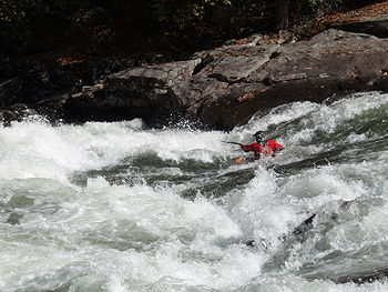
Lenape
The Lenape are an Algonquian group of Native Americans of the Northeastern Woodlands. They are also called Delaware Indians. As a result of the American Revolutionary War and later Indian removals from the eastern United States, today the main groups live in Canada, where they are enrolled in the...
, like the others westerly of the state, who traded with the Spanish before the French arrival. It was Minsis
Munsee language
Munsee is an endangered language of the Eastern Algonquian subgroup of the Algonquian language family, itself a branch of the Algic language family. Munsee is one of the two Delaware languages...
and Mohican
Mohican
-Native Americans:* Mahican , a Native American tribe who lived in and around the Hudson Valley* Mohegan, a functional confederation of several branches of Native Americans during the 16th century and the beginning of the 17th century...
who led some Shawnee from Lower Ohio Valley in 1692 to join the Minisink villagers of the Delaware (Hanna 1911:158). Soon, these provided guides followed by the Viele of Albany Expedition. The Shawnee arrived later in the century by 1697 on the Eastern Panhandle with Sauvanoos from the south east colonies (Darlington; Hanna). Batts and Fallams, 1671, briefly mentions an abandoned Mohican village ('Mohecan' as transcribed journal entry date Sept. 16, 1671, Summers 1929) on the Kanawha-New River area. Beginning in the late 18th century on modern maps, Big and Little Loup creeks are found opposite of Alloy
Alloy, West Virginia
Alloy is an unincorporated community in Fayette County, West Virginia, United States. Alloy is located along the Kanawha River and U.S. Route 60 southwest of Gauley Bridge. Alloy was originally known as Boncar until the mid 1930's...
bottom below the Kanawha Falls
Kanawha Falls, West Virginia
Kanawha Falls is an unincorporated community in Fayette County, West Virginia, United States. Kanawha Falls is located on the east bank of the Kanawha River southwest of Gauley Bridge. Kanawha Falls had a post office, which opened on March 26, 1856, and closed on November 2, 2002....
about 3 miles. It is about 2 miles upstream of Mt Carbon
Mount Carbon, West Virginia
Mount Carbon is an unincorporated census-designated place in Fayette County, West Virginia, United States. Mount Carbon is located on the south bank of the Kanawha River and West Virginia Route 61 southeast of Montgomery. Mount Carbon has a post office with ZIP code 25139. As of the 2010 census,...
of Armstrong Creek with local ancient stone wall legends occasionally heard.
Alloy 46FA189 (Woodland) in Fayette County
Fayette County, West Virginia
As of the census of 2000, there were 47,579 people, 18,945 households, and 13,128 families residing in the county. The population density was 72 people per square mile . There were 21,616 housing units at an average density of 33 per square mile...
has less than 50% Z-twist or about 1/4th Iroquois-like (Cheroenhaka) decorated pottery. About a day's hike up the Gauley River
Gauley River
The Gauley River is a river in West Virginia. It merges with the New River to form the Kanawha River, a tributary of the Ohio River. It is one of the most popular advanced whitewater runs in the Eastern United States and is the chief feature of the Gauley River National Recreation Area.-Headwaters...
in Nicholas County is the type site Buck Garden 46NI49 Woodland (?46NI49 multi-level component) with about 3/4th Z-Twist finished pottery and nearby along the river bottom is Morrison Shelter 46NI8 Woodland (?46N18 multi-level component) with much less or about 1/4th Z-twist finished pottery. Several characteristic Siouan pottery can be found from various periods to include the Page pottery and the Algonquian S-Twist finish in this area. A few Algonquian Loup villages as marked S-Twist finish will appear at times on 18th century maps on the upper Ohio Valley near Wheeling
Wheeling, West Virginia
Wheeling is a city in Ohio and Marshall counties in the U.S. state of West Virginia; it is the county seat of Ohio County. Wheeling is the principal city of the Wheeling Metropolitan Statistical Area...
and Saint Marys through to Cheshire, Ohio
Cheshire, Ohio
Cheshire is a village in Gallia County, Ohio, United States, along the Ohio River. The population was 221 at the 2000 census. It is part of the Point Pleasant, WV–OH Micropolitan Statistical Area.-Geography:Cheshire is located at ....
. As mentioned, this era begins the sometimes called fire-side cabin culture having much Acculturation
Acculturation
Acculturation explains the process of cultural and psychological change that results following meeting between cultures. The effects of acculturation can be seen at multiple levels in both interacting cultures. At the group level, acculturation often results in changes to culture, customs, and...
during the Fur Trade
Fur trade
The fur trade is a worldwide industry dealing in the acquisition and sale of animal fur. Since the establishment of world market for in the early modern period furs of boreal, polar and cold temperate mammalian animals have been the most valued...
era. There appear to be no primary source of Loup and early protohistoric Cisca mixing, closest Algonqiuan being eastern Kentucky Chaouanon and eastern Tennessee Yuchi cited earlier— Cheskepe.
Also historically scattered through this same area of Loups at times will be found a few Guyandotte, Mingoe and western Virginia Iroquois-like (Cheroenhaka) villages. Frontier political insight of the refugee or cabin culture people can be gleened from the C Gist journal of 1750, "Sunday Nov 5.—Down the River W 3 M, NW 5 M to Loggs Town; the Lands these last 8 M very rich the Bottoms above a Mile wide, but on the SE side, scarce a Mile wide, the Hills high and steep. In the Loggs Town, I found scarce any Body but a Parcel of reprobate Indian Traders, the Chiefs of the Indians being out a hunting: here I was informed that George Croghan & Andrew Montour who were sent upon an Embassy from Pensylvania to the Indians, were passed about a Week before me. The People in this Town, began to enquire my Business, and because I did not readily inform them, they began to suspect me, and said, I was come to settle the Indian's Lands and they knew I should never go Home again safe; I found this Discourse was like to be of ill Consequence to me, so I pretended to speak very slightingly of what they had said to me, and enquired for Croghan (who is a meer Idol among his Countrymen the Irish Traders) and Andrew Montour the Interpreter for Pensylvania, and told them I had a Message to deliver the Indians from the King, by Order of the President of Virginia, & for that Reason wanted to see M Montour: This made them all pretty easy (being afraid to interrupt the King's Message) and obtained me Quiet and Respect among them, otherwise I doubt not they woud have contrived some Evil against me—I immediately wrote to M Croghan, by one of the Trader's People."
Delaware Chief Bull's old town, son of Teedyuscung
Teedyuscung
Teedyuscung was known as King of the Delawares. He worked to establish a permanent Lenape home in eastern Pennsylvania in the Lehigh, Susquehanna and Delaware River valleys. Teedyuscung participated in the Treaty of Easton which resulted in the loss of any Lenape claims to all lands in Pennsylvania...
, of Burnsville Lake
Burnsville Lake
Burnsville Lake is both a recreational and flood control reservoir on Little Kanawha River located southeast of Burnsville in Braxton County, West Virginia. Burnsville Lake was authorized by the U.S. Congress in the Flood Control Act of 1938....
Wildlife Management Area in Braxton County, dates from 1754 through 1772. They migrated to the White River
White River (Indiana)
The White River is a two-forked river that flows through central and southern Indiana and is the main tributary to the Wabash River. Via the west fork, considered to be the main stem of the river by the U.S. Board on Geographic Names, the White River is long.-West Fork:The West Fork, long, is...
, 18 miles from the Wabash
Wabash River
The Wabash River is a river in the Midwestern United States that flows southwest from northwest Ohio near Fort Recovery across northern Indiana to southern Illinois, where it forms the Illinois-Indiana border before draining into the Ohio River, of which it is the largest northern tributary...
. Of these and colonial assimilation, there are still some descendants living in West Virginia
See: Eastern Algonquian languages
Eastern Algonquian languages
The Eastern Algonquian languages constitute a subgroup of the Algonquian languages. Prior to European contact, Eastern Algonquian consisted of at least seventeen languages collectively occupying the Atlantic coast of North America and adjacent inland areas, from the Canadian Maritime provinces to...
and Proto-Algonquian language
Proto-Algonquian language
Proto-Algonquian is the name given to the proto-language from which the various languages of the Algonquian family are descended. It is generally estimated to have been spoken around 2,500 to 3,000 years ago, but on the question of where it was spoken there is less agreement...
.
Tionontatacaga
Tionontatacaga (Tobacco Indians, Iroquois) trade mixing from easterly regional tributaries of Lake ErieLake Erie
Lake Erie is the fourth largest lake of the five Great Lakes in North America, and the tenth largest globally. It is the southernmost, shallowest, and smallest by volume of the Great Lakes and therefore also has the shortest average water residence time. It is bounded on the north by the...
were generally traditional Iroquois League enemies. The early historic Ohio Valley Siouans were neighbors to the north-easterly Cat Nation of Erielhoran and their trade neighbor on their eastern environs, the Neutral Nation. The prehistoric culture of the Cat Nation region was named for Charles Whittlesey, a 19th century geologist and archaeologist who began the studies of the Whittlesey Culture (AD 1000 to 1600) and founded the Western Reserve Historical Society of Ohio. From Fort Ancient people, AD 1150–1200, beans were included in Whittlesey people's corn fields. Neighboring to the west along Lake Erie's tributaries were the palisaded villages of the Sandusky culture (c. AD 1400–1500). A Late Woodland people were south of the Sandusky people and south-westerly of the Whittlesey people on the rolling hill watershed of these tributaries in Ohio. A connection of these various Prehistoric people with historic tribes remain unclear for the increasing migrations (Ohio Historical Society).
.* According to William C. Noble of the "Encyclopedia of Canada's Peoples" (1984, 1985, 1994), "The Neutral
Neutral Nation
The Neutrals, also known as the Attawandaron, were an Iroquoian nation of North American native people who lived near the shores of Lake Ontario and Lake Erie.-Territory:...
had trading and war alliances with surrounding Iroquoian-speaking peoples, particularly the Petun
Petun
The Petún , or Tionontati in their language, were an Iroquoian-speaking First Nations people closely related to the Wendat Confederacy. Their homeland was located along the southwest edge of Georgian Bay, in the area immediately to the west of the Huron territory in Southern Ontario of...
, Huron, Wenro, Kakwa
Cree language
Cree is an Algonquian language spoken by approximately 117,000 people across Canada, from the Northwest Territories and Alberta to Labrador, making it the aboriginal language with the highest number of speakers in Canada. It is also spoken in the U.S. state of Montana...
, Erie, Andasté, Massawomek and Iroquois further south." Chief Tsouharissen included a council which united some 10 "tribes" within the Neutralia empire . French Recollet friar Daillon in 1626 reported 3 large deer pens near his village, Ounontisaston. They called themselves Chonnonton, or "people of the deer." Because these ranging trademen were at peace earlier with the League and Huron, in 1615 Champlain called them, "la Nation neutre". They traded deer hides and byproducts to as far south as the Powhatan
Powhatan
The Powhatan is the name of a Virginia Indian confederation of tribes. It is estimated that there were about 14,000–21,000 of these native Powhatan people in eastern Virginia when the English settled Jamestown in 1607...
chiefdom on Chesapeake Bay
Chesapeake Bay
The Chesapeake Bay is the largest estuary in the United States. It lies off the Atlantic Ocean, surrounded by Maryland and Virginia. The Chesapeake Bay's drainage basin covers in the District of Columbia and parts of six states: New York, Pennsylvania, Delaware, Maryland, Virginia, and West...
for the prized Snow Whelk (Buccinidae
Buccinidae
Buccinidae is a very large and diverse taxonomic family of large sea snails, often known as whelks or true whelks.True whelks are mostly marine gastropod mollusks in the clade Neogastropoda...
) marine shell
Mollusca
The Mollusca , common name molluscs or mollusksSpelled mollusks in the USA, see reasons given in Rosenberg's ; for the spelling mollusc see the reasons given by , is a large phylum of invertebrate animals. There are around 85,000 recognized extant species of molluscs. Mollusca is the largest...
s. The Iroquois League in 1651 destroyed this cultural entity. Having been pushed south and pressuring the Siouan, these Wyandot mix again disseminated. Like the decades earlier of some northerly environ Yuchi
Yuchi
For the Chinese surname 尉迟, see Yuchi.The Yuchi, also spelled Euchee and Uchee, are a Native American Indian tribe who traditionally lived in the eastern Tennessee River valley in Tennessee in the 16th century. During the 17th century, they moved south to Alabama, Georgia and South Carolina...
, some Tionontatacaga joined the Shawnee and other Wyandot were known as Little Mingoe (Gist 1750–51). The Guyandotte River
Guyandotte River
The Guyandotte River is a tributary of the Ohio River, approximately 166 mi long, in southwestern West Virginia in the United States. It was named after the French term for the Wendat Native Americans...
was named in their memory.
New York trade
Leading up to the first New York trade in the Ohio Valley of 1692–94, "In a speech on August 5, 1684, Dongan urged the Iroquois to make an offensive and defensive alliance with the Ottawa, the Miami, and 'further Indians' (Ohio Valley 'Showanoes') and to open a path (through Chiroenhaka) for them to come to Albany to trade (Broshar, 1920 page 232)." Fort Henry (Virginia) had some two decades earlier established trade into the state. As mentioned in a previous section, there is evidence of "inter-tribal" trade during the protohistoric "trans-Native American" European trade from distant contact areas, Occaneechee-Yuchee. However, by these decades the Virginian Chiroenhaka trade in the Mountain State emerges, those of traditional enemies of the New England League as cited within another section here. Under the name Chaskepe in 1683, some Cisca seem to have joined with the ShawneeShawnee
The Shawnee, Shaawanwaki, Shaawanooki and Shaawanowi lenaweeki, are an Algonquian-speaking people native to North America. Historically they inhabited the areas of Ohio, Virginia, West Virginia, Western Maryland, Kentucky, Indiana, and Pennsylvania...
who relocate to Fort St. Louis
Starved Rock State Park
Starved Rock State Park is a state park in Illinois, characterized by the many canyons within its 2360 acres. Located just southwest of the village of North Utica, in Deer Park Township, LaSalle County, Illinois, along the south bank of the Illinois River, the park hosts over two million visitors...
in Illinois
Illinois
Illinois is the fifth-most populous state of the United States of America, and is often noted for being a microcosm of the entire country. With Chicago in the northeast, small industrial cities and great agricultural productivity in central and northern Illinois, and natural resources like coal,...
and lived among the French trade (Hanna). Continue quoting Helen Broshar, "Dongan in September, 1687, could say with truth, 'and as to their [the Iroquois’] Warring with the farther Indyans (Ohio Valley 'Showanoes') that is more hurtfull to us than the French they being inclined to trade with us rather than them which by their Warring is hindered'."
Nearly a century later, local stories were still being told of this period of warring and trade establishment. George Washington
George Washington
George Washington was the dominant military and political leader of the new United States of America from 1775 to 1799. He led the American victory over Great Britain in the American Revolutionary War as commander-in-chief of the Continental Army from 1775 to 1783, and presided over the writing of...
was about 15 miles below Wheeling
Wheeling, West Virginia
Wheeling is a city in Ohio and Marshall counties in the U.S. state of West Virginia; it is the county seat of Ohio County. Wheeling is the principal city of the Wheeling Metropolitan Statistical Area...
, Marshall County
Marshall County, West Virginia
As of the census of 2000, there were 35,519 people, 14,207 households, and 10,101 families residing in the county. The population density was 116 people per square mile . There were 15,814 housing units at an average density of 52 per square mile...
according to his entry on Thursday October 25, 1770. An early Cut Creek Indian town was wiped out on Cut Creek (Fish Creek) by the Six Nations (Haudenosaunee) according to the hired Crawford Indians (William Crawford (soldier)
William Crawford (soldier)
William Crawford was an American soldier and surveyor who worked as a western land agent for George Washington. Crawford fought in the French and Indian War and the American Revolutionary War...
Iroquois-like George Ck neighbors) and the two Croghan Indians (neighboring villagers) aboard with him from "White Mingos Castle" (LOC, Jackson & Twohig 1976:293,294). These western Virginia Indians with George Washington explained the geograghy of each stream they passed on the Ohio River
Ohio River
The Ohio River is the largest tributary, by volume, of the Mississippi River. At the confluence, the Ohio is even bigger than the Mississippi and, thus, is hydrologically the main stream of the whole river system, including the Allegheny River further upstream...
to and up the Great Kanawha. With some of the hired Indians, Washington spent the night of November 2, 1770 at the old hunters camp at the 10 Mile Creek before returning to the main camp at the Mouth of the Kanawha (LOC, Jackson & Twohig 1976:307,308). This was as far up the Kanawha he personally assessed in 1770. A few days before, he and some of the expedition party hunted through Old Town Creek area near the Old Shawnatown (Cook, 25). Here too, he notes, could be considered for those soldiers claim who had served with him. Croghan had ordered for a separate boat of his Indians at the beginning of the voyage. Croghan in his third boat went as far as Mingo Town. In 1769 for cargo delivery, Croghan paid "the settled Indian wages here are 4s. a day, York currency, being half a dollar" (Hanna 1911:63). Apparently not obliged to pay the Croghan Indians, Washington "paid the Pheasant and the young warrior £10 138. for their services on the trip to the Ohio," according to Jackson & Twohig (Ledger A, 329). There are at least two documented different contemporary Indians named Pheasant in the region. (Credit Line: Library of Congress
Library of Congress
The Library of Congress is the research library of the United States Congress, de facto national library of the United States, and the oldest federal cultural institution in the United States. Located in three buildings in Washington, D.C., it is the largest library in the world by shelf space and...
, Manuscript Division)
In another reference to 'far Indians', "In August, 1675, Governor Andros went to Albany and had a conference with the 'most warrlike Indyans neare a hundred miles beyound Albany which Indyans [and Associates to about four hundred miles further] applied, declaring their former Allyance, and now submitted in an Extraordinary manner'." O'Callaghan continues, "Again in the late fall of 1677 Andros dispatched two white interpreters into the west to protest against the raids of the Iroquois and far Indians on the southern colonies." William H. Egle figured the acculturating Massawomeke would be later known by the name of historic "Mohawk".
Virginia trade
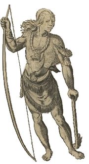
Allegheny Mountains
The Allegheny Mountain Range , also spelled Alleghany, Allegany and, informally, the Alleghenies, is part of the vast Appalachian Mountain Range of the eastern United States and Canada...
region began with Jamestown, Virginia
Jamestown, Virginia
Jamestown was a settlement in the Colony of Virginia. Established by the Virginia Company of London as "James Fort" on May 14, 1607 , it was the first permanent English settlement in what is now the United States, following several earlier failed attempts, including the Lost Colony of Roanoke...
. In the 1999 Interim Report (Mallios and Strube, 2000), the Massawomeck offered gifts of Bows and Arrows, deer and bear flesh, fish, clubs, and bear skins to John Smith during his Chesapeake Bay
Chesapeake Bay
The Chesapeake Bay is the largest estuary in the United States. It lies off the Atlantic Ocean, surrounded by Maryland and Virginia. The Chesapeake Bay's drainage basin covers in the District of Columbia and parts of six states: New York, Pennsylvania, Delaware, Maryland, Virginia, and West...
exploration in 1608. Next, the Susquesahanock came down and presented venison, tobacco pipes, baskets, targets, bows and arrows (Barbour, I:231). A rather large cashe of small and very well made dark flint Levanna, and small excellently proportioned type of Madison arrow points appear to be from some of these trade or gifts at the Jamestown archaeological site. The abstract explains these were not found strung about the site as if shot into the village. It is not mentioned the meat was either smoked or salt cured. Susquesahanock brought in more to agrarian as seen in the list. John Smith (explorer) wrote of the Susquehannock, "They can make neere 600 able and mighty men, and are pallisadoed in their Townes to defend them from the Massawomekes their mortall enimies."
A brief protohistoric account by Conway Whittle and B.L. Sams in 1916 of Susquehannock in quote, "It is said that the Sus-que-han-oughs originally occupied the headwaters of the Chesapeake Bay, but were driven out by the Cin-e-la tribe and took up their residence on the upper waters of the Potomac, which was supposed to be one of their favorite places of residence, as the remains of their villages are more numerous in this region than elsewhere in the Valley." Todays modern archaeological sites in north eastern West Virginia seems to be providing a credence to this old legend.
In the early 17th century, a situation of Messawomeake, from beyond the western slopes of the upper Allegheny Mountains
Allegheny Mountains
The Allegheny Mountain Range , also spelled Alleghany, Allegany and, informally, the Alleghenies, is part of the vast Appalachian Mountain Range of the eastern United States and Canada...
, migration to the upper Potomac area for the sake of being closer to English trade ware appears. This was battling circumstances with the Iroquois Trade middlemen the Algonquian
Algonquian languages
The Algonquian languages also Algonkian) are a subfamily of Native American languages which includes most of the languages in the Algic language family. The name of the Algonquian language family is distinguished from the orthographically similar Algonquin dialect of the Ojibwe language, which is a...
Nacotchtank
Nacotchtank
The Nacotchtank were a native Algonquian people who lived in the area of what is now Washington, D.C. during the 17th century. Their principal village was situated within the modern borders of the District of Columbia, on the eastern bank of a small river that still bears an anglicised variant of...
in 1632. Leaving French Canadian trade, they arrived and began trade with Captain Henry Fleet on the upper Chesapeake Bay. Messawomeake settled northerly tributaries of the upper Potomac Valley
Potomac River
The Potomac River flows into the Chesapeake Bay, located along the mid-Atlantic coast of the United States. The river is approximately long, with a drainage area of about 14,700 square miles...
. It appears a period of general peace followed with the Algonquian down the Potomac. Archaeology does not enough know of a connection by the Messawomeake arrival with the Susquehanna Site 46Hy89 (1550–1630). The little known Cinelas were nearby on the Upper Potomac and the Senedos occupied the north fork of the Shenandoah Valley
Shenandoah Valley
The Shenandoah Valley is both a geographic valley and cultural region of western Virginia and West Virginia in the United States. The valley is bounded to the east by the Blue Ridge Mountains, to the west by the eastern front of the Ridge-and-Valley Appalachians , to the north by the Potomac River...
until 1732 destroyed by hostile tribes from the south (Whittle and Sams 1916:372,374). A phratry of Tuscaroras had their village in Berkeley county
Berkeley County, West Virginia
Berkeley County is a county located in the Eastern Panhandle region of the U.S. state of West Virginia. As of 2010, the population is 104,169, making it the second-most populous county in West Virginia, behind Kanawha...
neighboring similar stock Massawomecks.
In the 1640s, the Virginia Colony built Fort Henry
Fort Henry (Virginia)
Fort Henry was an English frontier fort in 17th century colonial Virginia near the falls of the Appomattox River. Its exact location has been debated, but the most popular one is on a bluff about four blocks north of the corner of W. Washington and N...
was noted by historians to trade with the eastern Siouan
Siouan languages
The Western Siouan languages, also called Siouan proper or simply Siouan, are a Native American language family of North America, and the second largest indigenous language family in North America, after Algonquian...
of proto-historic West Virginia. Abraham Wood
Abraham Wood
Abraham Wood , sometimes referred to as "General" or "Colonel" Wood, was an English fur trader and explorer of 17th century colonial Virginia...
later acquired it. A fort built of particular protohistoric interest was the James River Fort of William Byrd I
William Byrd I
William Byrd I was a native of Shadwell, London, England. His father, John Byrd was a London goldsmith with ancestral roots in Cheshire, England....
established in 1676. It was still closer to Tutelo groups, elemental Swanton's Toteras of interest, and its nearby Monacan east of Roanoke
Roanoke, Virginia
Roanoke is an independent city in the Mid-Atlantic U.S. state of Virginia and is the tenth-largest city in the Commonwealth. It is located in the Roanoke Valley of the Roanoke Region of Virginia. The population within the city limits was 97,032 as of 2010...
area and Kanawhan 'Monetons
Monetons
The Moneton people were a historical Native American tribe from West Virginia'. In the late 17th century, they lived in the Kanawha Valley, near the Kanawha and New Rivers.-Name:...
' following Wood's 1674 contact. Monecaga were a westerly subset of Monacan. According to John Lederer
John Lederer
John Lederer was a 17th-century German physician and an explorer of the Appalachian Mountains. He and the members of his party became the first Europeans to crest the Blue Ridge Mountains and the first to see the Shenandoah Valley and the Allegheny Mountains beyond...
recorded in 1670, the Monacan had been driven by enemies from the northwest into James River
James River
The James River may refer to:Rivers in the United States and their namesakes* James River * James River , North Dakota, South Dakota* James River * James River * James River...
and Blue Ridge Mountains
Blue Ridge Mountains
The Blue Ridge Mountains are a physiographic province of the larger Appalachian Mountains range. This province consists of northern and southern physiographic regions, which divide near the Roanoke River gap. The mountain range is located in the eastern United States, starting at its southern-most...
region of Virginia
Virginia
The Commonwealth of Virginia , is a U.S. state on the Atlantic Coast of the Southern United States. Virginia is nicknamed the "Old Dominion" and sometimes the "Mother of Presidents" after the eight U.S. presidents born there...
about 1250. There they found a Hunter-gathering people who did not grow corn. Along with Shattera, these were among the Occane-Uchi Virginia trade through the southerly of the state.
Conclusion
Marshall University
Marshall University is a coeducational public research university in Huntington, West Virginia, United States founded in 1837, and named after John Marshall, the fourth Chief Justice of the United States....
Graduate College, as Dr Maslowski explains, "Europeans operated under a capitalist ideology while Native Americans operated under an ideology of reciprocity."
In 'The Catholic Encyclopedia' , quoting McMahon, F. (1912), "Different Indian tribes at various times had their homes within the present limits of the state: the Delawares in the Monongahela Valley; the Mohicans in the Kanawha Valley; the Conoys in the New River Valley, and the Shawnees on the south branch of the Potomac." Quoting Margaret M. Nava, "The association of Fort Ancient and Monongahela cultures with present day American Indian tribes is, at present, educated guesswork. Some scientists speculate that the Fort Ancients were somehow related to the Kanawha River Moneton and Western Shawnee and that the Monongahela may have evolved into the Arrigahaga or 'Black Minqua' , the Susquehannock or 'White Minqua' , or 'Tramontane Indians' identified as the Honniasontkeronon." Hanna defines Honniasontkeronon as an Iroquois phrase, people of the place of crook-necked squashes, or people of the place where they wear crosses. Hodge defines Hoñniasontke'roñnon as an Iroquois euphemism for 'the land of departed spirits' . Anthropologist Carol Lowery Delaney indirectly explains political correctness is of euphemism
Euphemism
A euphemism is the substitution of a mild, inoffensive, relatively uncontroversial phrase for another more frank expression that might offend or otherwise suggest something unpleasant to the audience...
which "conceals the political implications."
The question is, when did each of these peoples appear or arrise in 'the land of departed spirits' ? Answering this question is the work of a mix of regional scholars, which includes Native American
Indigenous peoples of the Americas
The indigenous peoples of the Americas are the pre-Columbian inhabitants of North and South America, their descendants and other ethnic groups who are identified with those peoples. Indigenous peoples are known in Canada as Aboriginal peoples, and in the United States as Native Americans...
scholars of linguistics among others, in and neighboring the 'Mountain State' .
Today, Wayne Gray Owl Appleton, PhD, West Virginia Division of Culture and History, summarizes Native American in West Virginia, "The contemporary community includes longtime residents who are finding new pride in their native heritage, and Native Americans who are newcomers to this area and who represent the pan-Indian community. The Native American community has struggled with oppression, imposed disruption, and insecurity since the arrival of European settlers in West Virginia. According to newspaper reports, individuals were being shipped away to Oklahoma reservations as late as the 1950s. Until 1965, it was considered technically illegal for a Native American to own property in West Virginia, though this law was seldom enforced. In spite of these hardships, vestiges of communities survived and their heritage is re-emerging with renewed pride."
External links
- "The Kanawha Valley and its Prehistoric People" by Dr. Robert F. Maslowski
- "Archeology of the Great Kanawha Navigation" by Robert F. Maslowski
- Mason County, West Virginia – An Archaeological Treasure Photos and descriptions of artifacts from protohistoric sites in West Virginia
- Images from Moorefield Village Site 46 Hy 89 Photos from a Susquehannock site
- Videos of West Virginia archeology, Division of Culture and History
- West Virginia Archeological Society Annual Meeting 2008
- Archaeology Videos by region, The Archaeology Channel