
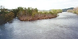
Holston River
Encyclopedia

River
A river is a natural watercourse, usually freshwater, flowing towards an ocean, a lake, a sea, or another river. In a few cases, a river simply flows into the ground or dries up completely before reaching another body of water. Small rivers may also be called by several other names, including...
system of southwestern
Southwest Virginia
Southwest Virginia, often abbreviated as SWVA, is a mountainous region of Virginia in the westernmost part of the commonwealth. Southwest Virginia has been defined alternatively as all Virginia counties on the Appalachian Plateau, all Virginia counties west of the Eastern Continental Divide, or...
Virginia
Virginia
The Commonwealth of Virginia , is a U.S. state on the Atlantic Coast of the Southern United States. Virginia is nicknamed the "Old Dominion" and sometimes the "Mother of Presidents" after the eight U.S. presidents born there...
and east Tennessee
East Tennessee
East Tennessee is a name given to approximately the eastern third of the U.S. state of Tennessee, one of the three Grand Divisions of Tennessee defined in state law. East Tennessee consists of 33 counties, 30 located within the Eastern Time Zone and three counties in the Central Time Zone, namely...
. The three major forks of the Holston (its North, Middle and South Forks) rise in southwestern Virginia and have their confluence near Kingsport, Tennessee
Kingsport, Tennessee
Kingsport is a city located mainly in Sullivan County with some western portions in Hawkins County in the US state of Tennessee. The majority of the city lies in Sullivan County...
. The North Fork flows 138 miles (222.1 km) southwest from Sharon Springs in Bland County, Virginia
Bland County, Virginia
As of the census of 2000, there were 6,871 people, 2,568 households, and 1,908 families residing in the county. The population density was 19 people per square mile . There were 3,161 housing units at an average density of 9 per square mile...
. The Middle Fork flows 56.5 miles (90.9 km) from near the western border of Wythe County, Virginia
Wythe County, Virginia
As of the census of 2000, there were 27,599 people, 11,511 households, and 8,103 families residing in the county. The population density was 60 people per square mile . There were 12,744 housing units at an average density of 28 per square mile...
, joining the South Fork in Washington County
Washington County, Virginia
As of the census of 2000, there were 51,103 people, 21,056 households, and 14,949 families residing in the county. The population density was 91 people per square mile . There were 22,985 housing units at an average density of 41 per square mile...
southeast of Abingdon
Abingdon, Virginia
Abingdon is a town in Washington County, Virginia, USA, 133 miles southwest of Roanoke. The population was 8,191 at the 2010 census. It is the county seat of Washington County and is a designated Virginia Historic Landmark...
. The South Fork rises near Sugar Grove
Sugar Grove, Virginia
Sugar Grove is a census-designated place in Smyth County, Virginia, United States. The population was 741 at the 2000 census.-Geography:Sugar Grove is located at ....
in Wythe County and flows 112 miles (180.2 km) southwest to join the North Fork at Kingsport. From there the main stem of the Holston River flows 136 miles (218.9 km) roughly southwestward, just north of Bays Mountain
Bays Mountain
Bays Mountain is a ridge of the Ridge-and-Valley Appalachians, located in eastern Tennessee. It runs southwest to northeast, from just south of Knoxville to Kingsport.Its southern segment is relatively low in elevation...
, until it reaches its confluence
Confluence
Confluence, in geography, describes the meeting of two or more bodies of water.Confluence may also refer to:* Confluence , a property of term rewriting systems...
with the French Broad River
French Broad River
The French Broad River flows from near the village of Rosman in Transylvania County, North Carolina, into the state of Tennessee. Its confluence with the Holston River at Knoxville is the beginning of the Tennessee River....
just east of downtown Knoxville, Tennessee
Knoxville, Tennessee
Founded in 1786, Knoxville is the third-largest city in the U.S. state of Tennessee, U.S.A., behind Memphis and Nashville, and is the county seat of Knox County. It is the largest city in East Tennessee, and the second-largest city in the Appalachia region...
. This confluence is considered to be the start of the Tennessee River
Tennessee River
The Tennessee River is the largest tributary of the Ohio River. It is approximately 652 miles long and is located in the southeastern United States in the Tennessee Valley. The river was once popularly known as the Cherokee River, among other names...
.
The Holston River valley is greatly developed for electrical
Electricity
Electricity is a general term encompassing a variety of phenomena resulting from the presence and flow of electric charge. These include many easily recognizable phenomena, such as lightning, static electricity, and the flow of electrical current in an electrical wire...
power generation, both with hydroelectric dam
Dam
A dam is a barrier that impounds water or underground streams. Dams generally serve the primary purpose of retaining water, while other structures such as floodgates or levees are used to manage or prevent water flow into specific land regions. Hydropower and pumped-storage hydroelectricity are...
s and coal
Coal
Coal is a combustible black or brownish-black sedimentary rock usually occurring in rock strata in layers or veins called coal beds or coal seams. The harder forms, such as anthracite coal, can be regarded as metamorphic rock because of later exposure to elevated temperature and pressure...
-fired steam plants. In its upper reaches some of these plants are controlled by private interests; in the downstream portion they are owned by the United States Government's Tennessee Valley Authority
Tennessee Valley Authority
The Tennessee Valley Authority is a federally owned corporation in the United States created by congressional charter in May 1933 to provide navigation, flood control, electricity generation, fertilizer manufacturing, and economic development in the Tennessee Valley, a region particularly affected...
. Among the dams and associated reservoirs on the South Fork Holston River are Boone Dam
Boone Dam
Boone Dam is a hydroelectric and flood control dam on the South Fork Holston River on the border between Sullivan County and Washington County in the U.S. state of Tennessee...
and Boone Reservoir
Boone Lake
Boone Lake is a reservoir in Sullivan and Washington counties in northeastern Tennessee, formed by the impoundment of the South Fork Holston River behind Boone Dam....
; Fort Patrick Henry Dam
Fort Patrick Henry Dam
Fort Patrick Henry Dam is a hydroelectric dam on the South Fork Holston River within the city of Kingsport, in Sullivan County in the U.S. state of Tennessee...
and Fort Patrick Henry Reservoir, and South Holston Dam
South Holston Dam
South Holston Dam is a hydroelectric and flood control dam on the South Fork Holston River in Sullivan County, in the U.S. state of Tennessee. It is the uppermost of three dams on the South Fork Holston owned and operated by the Tennessee Valley Authority, which built the dam in the 1940s as part...
and South Holston Reservoir
South Holston Lake
South Holston Lake is located near the cities of Abingdon, Virginia and Bristol, Virginia / Bristol, Tennessee, and is a impoundment operated by the Tennessee Valley Authority . Much of the reservoir is in Tennessee, but the Virginia portion of the reservoir offers anglers more than of water...
. Cherokee Dam
Cherokee Dam
Cherokee Dam is a hydroelectric dam located on the Holston River in Grainger County and Jefferson County, Tennessee, in the southeastern United States. The dam is operated and maintained by the Tennessee Valley Authority, which built the dam in the early 1940s to help meet urgent demands for...
on the Holston River forms Cherokee Reservoir
Cherokee Reservoir
Cherokee Reservoir, also known as Cherokee Lake, is a reservoir in Tennessee formed by the impoundment of the Holston River behind Cherokee Dam.The reservoir has a surface area of about , a flood-storage capacity of , and nearly of shoreline...
.
The river was named after Stephen Holstein, who built a cabin
Log cabin
A log cabin is a house built from logs. It is a fairly simple type of log house. A distinction should be drawn between the traditional meanings of "log cabin" and "log house." Historically most "Log cabins" were a simple one- or 1½-story structures, somewhat impermanent, and less finished or less...
on the upper reaches of the river in 1746. Holston Mountain
Holston Mountain
Holston Mountain is a mountain ridge in Upper East Tennessee and southwest Virginia, in the United States. It is in the Blue Ridge Mountains part of the Appalachian Mountains...
was named after the Holston River.
Although the Holston River is now defined as ending at the French Broad River to form the Tennessee River at its mile post 652 in Knoxville, before 1933 the terminus of the Holston River was defined as the location 51 miles (82.1 km) downstream of Knoxville at Lenoir City
Lenoir City, Tennessee
Lenoir City is a city in Loudon County, Tennessee, United States. Its population was 8,642 at the 2010 census. It is included in the Knoxville Metropolitan Area....
where the Little Tennessee River
Little Tennessee River
The Little Tennessee River is a tributary of the Tennessee River, approximately 135 miles long, in the Appalachian Mountains in the southeastern United States.-Geography:...
enters the river. That point, the confluence of the Holston and Little Tennessee rivers, was considered to be the beginning of the Tennessee River, 601 miles (967.2 km) upstream from the Ohio River
Ohio River
The Ohio River is the largest tributary, by volume, of the Mississippi River. At the confluence, the Ohio is even bigger than the Mississippi and, thus, is hydrologically the main stream of the whole river system, including the Allegheny River further upstream...
at Paducah, Kentucky
Paducah, Kentucky
Paducah is the largest city in Kentucky's Jackson Purchase Region and the county seat of McCracken County, Kentucky, United States. It is located at the confluence of the Tennessee River and the Ohio River, halfway between the metropolitan areas of St. Louis, Missouri, to the west and Nashville,...
. According to Tennessee Valley Authority historians, when the Tennessee Valley Authority was created in 1933, Congress mandated that the TVA headquarters be located on the banks of the Tennessee River. Since the TVA headquarters were to be located in downtown Knoxville on what was then the Holston River, in order to fulfill the Congressional mandate the official start of the Tennessee River was moved upstream from Lenoir City to the confluence of the Holston and French Broad rivers.
All three forks in Virginia, South Holston Lake, and the Holston River in Tennessee below the South Holston Dam offer relatively easy-to-reach recreation opportunities. The North Fork in Virginia is known as an excellent smallmouth bass
Smallmouth bass
The smallmouth bass is a species of freshwater fish in the sunfish family of the order Perciformes. It is the type species of its genus...
river (due to mercury
Mercury (element)
Mercury is a chemical element with the symbol Hg and atomic number 80. It is also known as quicksilver or hydrargyrum...
contamination, fish caught in the North Fork of the Holston below Saltville, Virginia
Saltville, Virginia
As of the census of 2000, there were 2,204 people, 909 households, and 660 families residing in the town. The population density was 273.7 people per square mile . There were 1,003 housing units at an average density of 124.5 per square mile...
should not be consumed), and both the South Fork in Virginia and the first 20 miles (32.2 km) of the Holston in Tennessee below South Holston Dam are quality brown trout
Brown trout
The brown trout and the sea trout are fish of the same species....
and rainbow trout
Rainbow trout
The rainbow trout is a species of salmonid native to tributaries of the Pacific Ocean in Asia and North America. The steelhead is a sea run rainbow trout usually returning to freshwater to spawn after 2 to 3 years at sea. In other words, rainbow trout and steelhead trout are the same species....
fisheries, with the latter wide and open enough to allow extensive fly fishing
Fly fishing
Fly fishing is an angling method in which an artificial 'fly' is used to catch fish. The fly is cast using a fly rod, reel, and specialized weighted line. Casting a nearly weightless fly or 'lure' requires casting techniques significantly different from other forms of casting...
to take place. South Holston Lake offers a variety of fishing opportunity as well, containing smallmouth bass, common carp
Common carp
The Common carp is a widespread freshwater fish of eutrophic waters in lakes and large rivers in Europe and Asia. The wild populations are considered vulnerable to extinction, but the species has also been domesticated and introduced into environments worldwide, and is often considered an invasive...
, walleye
Walleye
Walleye is a freshwater perciform fish native to most of Canada and to the northern United States. It is a North American close relative of the European pikeperch...
, pike, sunfish
Centrarchidae
The sunfishes are a family of freshwater ray-finned fish belonging to the order Perciformes. The type genus is Centrarchus . The family's 27 species includes many fishes familiar to North Americans, including the rock bass, largemouth bass, bluegill, pumpkinseed, and crappies...
, crappie
Crappie
Crappie is a genus of freshwater fish in the sunfish family of order Perciformes. The type species is P. annularis, the white crappie...
and a few trout.
See also
- List of Tennessee rivers
- List of Virginia rivers
- Watauga RiverWatauga RiverThe Watauga River is a large stream of western North Carolina and East Tennessee. It is 60 miles long with its headwaters on the slopes of Grandfather Mountain and Peak Mountain in Watauga County, North Carolina.-Hydrography:...
- Doe RiverDoe RiverThe Doe River is a naturally flowing river in northeast Tennessee that forms in Carter County near the North Carolina line, just south of Roan Mountain State Park.-Hydrography:...