
Gauley River
Encyclopedia
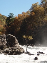
The Gauley River is a 105 miles (169 km) river in West Virginia
. It merges with the New River to form the Kanawha River
, a tributary
of the Ohio River
. It is one of the most popular advanced whitewater
runs in the Eastern United States
and is the chief feature of the Gauley River National Recreation Area
.
on Gauley Mountain in Pocahontas County
as three streams, the North, Middle, and South Forks, each of which flows across the southern extremity of Randolph County
; they converge in Webster County. The river then flows generally west-southwestwardly through Webster, Nicholas and Fayette
counties, past the towns of Camden-on-Gauley
and Summersville
, to the town of Gauley Bridge
, where it joins the New River to form the Kanawha River. Via the Kanawha and Ohio
rivers, it is part of the Mississippi River
watershed
.
, to form Summersville Lake
. The Gauley River National Recreation Area is downstream of the dam.
These releases are thanks to an act of the U.S. Congress, the first law passed in the U.S. to specifically mandate recreational whitewater dam releases. The releases bring millions of dollars annually to the local economy, as paddlers travel from all over the United States and overseas for this event.
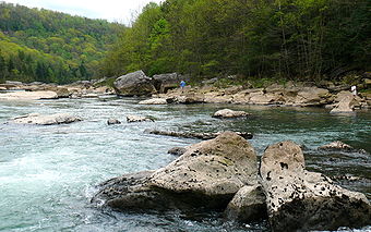
The Gauley has two commonly-run sections: the more difficult 9.8 miles (15.8 km) Upper Gauley (Class IV-V), and the easier 11 miles (17.7 km) Lower Gauley (Class III-IV, V). Portions of the 5.5 miles (8.9 km) Middle Gauley (Class III+, IV) are commonly run in conjunction with either the Upper or Lower Gauley, and it is sometimes run alone as a milder alternative.
As of 2008 the National Park Service developed a new, convenient take-out/put-in at Woods Ferry on the north side of the river (right bank). Not only does this improved public access avoid a strenuous hike and/or private landowner issues, but it conveniently divides the Gauley more closely in half between its upper class 5 section and its lower class 4 section. Backender Rapid, for example, was formerly on the tail end on the upper trip. That rapid is now technically the first class 4 rapid on the lower trip and is more consistent, difficulty-wise, with the rapids below it.
There are dozens of rapids on the Upper Gauley; the most notable are the "Big Five":
The Middle/Lower Gauley has fewer rapids and they are more spread out, but it also features big dramatic rapids that pose significant challenges. The list of Middle/Lower Gauley rapids includes:
A significant issue regarding legal access on the Gauley exists. Most of the access areas between the public put-in at the dam on the Upper Gauley and the last take-out for the Lower Gauley at Swiss are privately owned by rafting companies. Use of the popular Mason's Branch take-out has been tenuous at best through 2005 and 2006 and no good access exists for private paddlers to actually park near the river. Most have to hike their boats in or out of the gorge. Recently the National Parks Service has been hampered in its efforts to purchase and develop a public access point by a congressional mandate specifying that public access at Woods Ferry rapid (halfway down the Middle Gauley) be purchased and developed before any other area. This was largely seen as an attempt by two large and influential rafting companies with joint ownership of a developed access area to force the NPS to purchase their land. Whether or not this was the case, the situation was resolved through the development of a disused right of way on public land at Woods Ferry. Although this access point is not sufficient to service the crowds of boaters who descend upon the Gauley every year, its existence now permits the NPS to pursue other options for providing much needed public access.
on September 10, 1861, a Union victory in the American Civil War
.
 According to the Geographic Names Information System
, the Gauley River has also been known as:
West Virginia
West Virginia is a state in the Appalachian and Southeastern regions of the United States, bordered by Virginia to the southeast, Kentucky to the southwest, Ohio to the northwest, Pennsylvania to the northeast and Maryland to the east...
. It merges with the New River to form the Kanawha River
Kanawha River
The Kanawha River is a tributary of the Ohio River, approximately 97 mi long, in the U.S. state of West Virginia. The largest inland waterway in West Virginia, it has formed a significant industrial region of the state since the middle of the 19th century.It is formed at the town of Gauley...
, a tributary
Tributary
A tributary or affluent is a stream or river that flows into a main stem river or a lake. A tributary does not flow directly into a sea or ocean...
of the Ohio River
Ohio River
The Ohio River is the largest tributary, by volume, of the Mississippi River. At the confluence, the Ohio is even bigger than the Mississippi and, thus, is hydrologically the main stream of the whole river system, including the Allegheny River further upstream...
. It is one of the most popular advanced whitewater
Whitewater
Whitewater is formed in a rapid, when a river's gradient increases enough to disturb its laminar flow and create turbulence, i.e. form a bubbly, or aerated and unstable current; the frothy water appears white...
runs in the Eastern United States
United States
The United States of America is a federal constitutional republic comprising fifty states and a federal district...
and is the chief feature of the Gauley River National Recreation Area
Gauley River National Recreation Area
The Gauley River National Recreation Area, located near Summersville, West Virginia, protects a portion of the Gauley River and a segment of the Meadow River in southern West Virginia. Little of the park is accessible via roads; one must travel via the river...
.
Headwaters and course
The Gauley rises in the Monongahela National ForestMonongahela National Forest
The Monongahela National Forest is a national forest located in the Allegheny Mountains of eastern West Virginia, USA. It protects over of federally-owned land within a proclamation boundary that includes much of the Potomac Highlands Region and portions of 10 counties.The MNF includes some...
on Gauley Mountain in Pocahontas County
Pocahontas County, West Virginia
As of the census of 2000, there were 9,131 people, 835 households, and 527 families residing in the county. The population density was 10 people per square mile . There were 7,594 housing units at an average density of 8 per square mile...
as three streams, the North, Middle, and South Forks, each of which flows across the southern extremity of Randolph County
Randolph County, West Virginia
As of the census of 2000, there were 28,262 people, 11,072 households, and 7,661 families residing in the county. The population density was 27 people per square mile . There were 13,478 housing units at an average density of 13 per square mile...
; they converge in Webster County. The river then flows generally west-southwestwardly through Webster, Nicholas and Fayette
Fayette County, West Virginia
As of the census of 2000, there were 47,579 people, 18,945 households, and 13,128 families residing in the county. The population density was 72 people per square mile . There were 21,616 housing units at an average density of 33 per square mile...
counties, past the towns of Camden-on-Gauley
Camden-on-Gauley, West Virginia
Camden-on-Gauley is a town in Webster County, West Virginia, United States, along the Gauley River. The population was 157 at the 2000 census.-Geography:Camden-on-Gauley is located at ....
and Summersville
Summersville, West Virginia
Summersville is a town in Nicholas County, West Virginia, United States. The population was 3,194 at the 2000 census. It is the county seat of Nicholas County.-Geography:...
, to the town of Gauley Bridge
Gauley Bridge, West Virginia
Gauley Bridge is a town in Fayette County, West Virginia, United States. The population was 738 at the 2000 census. The Kanawha River is formed at Gauley Bridge by the confluence of the New and Gauley Rivers...
, where it joins the New River to form the Kanawha River. Via the Kanawha and Ohio
Ohio River
The Ohio River is the largest tributary, by volume, of the Mississippi River. At the confluence, the Ohio is even bigger than the Mississippi and, thus, is hydrologically the main stream of the whole river system, including the Allegheny River further upstream...
rivers, it is part of the Mississippi River
Mississippi River
The Mississippi River is the largest river system in North America. Flowing entirely in the United States, this river rises in western Minnesota and meanders slowly southwards for to the Mississippi River Delta at the Gulf of Mexico. With its many tributaries, the Mississippi's watershed drains...
watershed
Drainage basin
A drainage basin is an extent or an area of land where surface water from rain and melting snow or ice converges to a single point, usually the exit of the basin, where the waters join another waterbody, such as a river, lake, reservoir, estuary, wetland, sea, or ocean...
.
Tributaries
The Gauley's largest tributaries all flow into the main river from the east (flowing in a westerly direction) and are described as follows:- The Williams RiverWilliams River (West Virginia)The Williams River is a tributary of the Gauley River, 33 miles long, in east-central West Virginia, USA. Via the Gauley, Kanawha and Ohio Rivers, it is part of the watershed of the Mississippi River, draining an area of 132 square miles in a sparsely populated region of the southern Allegheny...
drains a segment of the Monongahela National ForestMonongahela National ForestThe Monongahela National Forest is a national forest located in the Allegheny Mountains of eastern West Virginia, USA. It protects over of federally-owned land within a proclamation boundary that includes much of the Potomac Highlands Region and portions of 10 counties.The MNF includes some...
, joining the Gauley in rural Webster County. - The Cranberry RiverCranberry River (West Virginia)The Cranberry River is a tributary of the Gauley River located in southeastern West Virginia, USA. It is a part of the Mississippi River watershed, by way of the Gauley, Kanawha, and Ohio Rivers, draining an area of ....
also flows through the Monongahela National Forest and empties into the Gauley in rural Nicholas County. - The Cherry RiverCherry River (West Virginia)The Cherry River is a tributary of the Gauley River in southeastern West Virginia, USA. Via the Gauley, Kanawha and Ohio rivers, it is part of the watershed of the Mississippi River. The Cherry River drains mostly rural and forested areas and flows for much of its length through the Monongahela...
, which initially flows through the town of RichwoodRichwood, West VirginiaRichwood is a city in Nicholas County, West Virginia, United States. The population was 2,477 at the 2000 census. A former coal and lumber boom town, the city's population once flirted with 10,000 but the closure of many underground coal mines caused many of Richwood's residents to leave the state...
, joins the Gauley near CraigsvilleCraigsville, West VirginiaCraigsville is a census-designated place in Nicholas County, West Virginia, United States. The population was 2,213 at the 2010 census.-Geography:Craigsville is located at ....
. - The Meadow RiverMeadow RiverThe Meadow River is a tributary of the Gauley River, making its headwaters in Greenbrier County and terminating in Nicholas County of West Virginia. It is named for the grassy meadows wetlands which its upper watershed drains, and from which it springs...
, which initially flows through the town of RainelleRainelle, West VirginiaRainelle is a town in Greenbrier County, West Virginia, United States. The population was 1,545 at the 2000 census.-History:Rainelle was named for the Raine family. Thomas and his brother John Raine moved there from Pennsylvania in 1906 to exploit one of the last large stands of virgin hardwoods in...
, joins the Gauley at the Fayette-Nicholas County border in the middle of the upper class 5 section.
Dams
In Nicholas County, the Gauley is impounded by the Summersville Dam, a U.S. Army Corps of Engineers damDam
A dam is a barrier that impounds water or underground streams. Dams generally serve the primary purpose of retaining water, while other structures such as floodgates or levees are used to manage or prevent water flow into specific land regions. Hydropower and pumped-storage hydroelectricity are...
, to form Summersville Lake
Summersville Lake
Summersville Lake is a reservoir located in the US state of West Virginia. The lake is formed by a rock-fill dam on the Gauley River, south of Summersville in Nicholas County...
. The Gauley River National Recreation Area is downstream of the dam.
Whitewater paddling
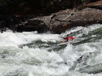
The Gauley is run year-round by recreational boaters and from spring to fall by commercial rafting companies. During the majority of the year, boating is dependent on water level, which fluctuates dramatically depending on rainfall and the level of Summersville Lake. However, starting the Friday after Labor Day, the Army Corps of Engineers provides a series of twenty-two controlled releases for the express purpose of downriver recreation. These releases are collectively known as "Gauley Season" and are scheduled on six successive weekends, the first five of which are four-day weekends (Friday through Monday) and the last of which is just Saturday and Sunday. Typical release levels during "Gauley Season" range from 2,400 to 2,800 ft³/s (68 to 79 m³/s).These releases are thanks to an act of the U.S. Congress, the first law passed in the U.S. to specifically mandate recreational whitewater dam releases. The releases bring millions of dollars annually to the local economy, as paddlers travel from all over the United States and overseas for this event.
The Gauley has two commonly-run sections: the more difficult 9.8 miles (15.8 km) Upper Gauley (Class IV-V), and the easier 11 miles (17.7 km) Lower Gauley (Class III-IV, V). Portions of the 5.5 miles (8.9 km) Middle Gauley (Class III+, IV) are commonly run in conjunction with either the Upper or Lower Gauley, and it is sometimes run alone as a milder alternative.
As of 2008 the National Park Service developed a new, convenient take-out/put-in at Woods Ferry on the north side of the river (right bank). Not only does this improved public access avoid a strenuous hike and/or private landowner issues, but it conveniently divides the Gauley more closely in half between its upper class 5 section and its lower class 4 section. Backender Rapid, for example, was formerly on the tail end on the upper trip. That rapid is now technically the first class 4 rapid on the lower trip and is more consistent, difficulty-wise, with the rapids below it.
There are dozens of rapids on the Upper Gauley; the most notable are the "Big Five":
- Insignificant (Class V - ironically so named because the first expedition reported "nothing significant before Pillow".)
- Pillow Rock (Class V - accessible via a steep trail from Carnifex Ferry Battleground site. Extremely powerful and intimidating rapid.)
- Lost Paddle (Class V - a long, treacherous rapid consisting of four sub-rapids: First Drop, Second Drop, Third Drop, and Tumblehome.)
- Iron Ring (Class V - so named for a large iron ring which had been anchored in a rock near the rapid by loggers many years before. The ring was cut and removed by vandals in the 1980s.)
- Sweet's Falls (Class V - named for John SweetJohn Sweet (canoer)John Sweet is an American slalom canoer who competed in the early 1980s. He won a silver medal in the mixed C-2 event at the 1981 ICF Canoe Slalom World Championships in Bala, Gwynedd, Wales.-References:*...
, a canoeist and pioneer of Gauley rafting in 1972. [formerly known as "The Devil's Backbone"])
The Middle/Lower Gauley has fewer rapids and they are more spread out, but it also features big dramatic rapids that pose significant challenges. The list of Middle/Lower Gauley rapids includes:
- Wood's Ferry (Class IV+ - a shallow rapid with large ledge pour-overs on river-left, "PJ's Hole" just right of center, and at the bottom, "Julie's Juicer", a twisting hydraulic flowing off the left side of a large rock in the center of the river.)
- Koontz's Flume (Class IV - Easily identifiable by an enormous undercut boulder clearly visible for a half mile or more upstream.)
- Canyon Doors (Class III - Named for vertical openings in the canyon wall on river right.)
- Upper and Lower Mash (Class IV - A complex boulder garden leading down to a swift flush, big breaking wave, and pinning rocks.)
- Rocky Top (Class III - A boulder strewn rapid with Little Hell Hole on river right at the bottom.)
- Heaven's Gate (Class IV - Long wave train leading to a narrow "gate" between a large rock and a dangerous pour-over at the bottom.)
- Upper and Lower Staircase (Class IV - a very long wave train rapid with interspersed pour-overs and ledge drops on the upper section, a massive curler waves on the lower part.)
- Rollercoaster (Class III - a fun wave-train rapid)
- Cliffside - (Class III - technical maneuvering at the top leads to an interesting slot against the cliff on river-left)
- Rattlesnake - (Class III - a bumpy ride.)
- Roostertail - (Class III - another fast wavetrain with a conspicuous roostertail wave near the bottom that hides a sharp rock inside.)
- Pure Screaming Hell (Class V - A long approach past consequential pourovers on the right, leading to a pair of large holes, Purgatory and Hell Hole, in addition to a very dangerous undercut sieve on the far right.)
A significant issue regarding legal access on the Gauley exists. Most of the access areas between the public put-in at the dam on the Upper Gauley and the last take-out for the Lower Gauley at Swiss are privately owned by rafting companies. Use of the popular Mason's Branch take-out has been tenuous at best through 2005 and 2006 and no good access exists for private paddlers to actually park near the river. Most have to hike their boats in or out of the gorge. Recently the National Parks Service has been hampered in its efforts to purchase and develop a public access point by a congressional mandate specifying that public access at Woods Ferry rapid (halfway down the Middle Gauley) be purchased and developed before any other area. This was largely seen as an attempt by two large and influential rafting companies with joint ownership of a developed access area to force the NPS to purchase their land. Whether or not this was the case, the situation was resolved through the development of a disused right of way on public land at Woods Ferry. Although this access point is not sufficient to service the crowds of boaters who descend upon the Gauley every year, its existence now permits the NPS to pursue other options for providing much needed public access.
History
The Gauley area was the site of the Battle of Carnifex FerryBattle of Carnifex Ferry
The Battle of Carnifex Ferry took place on September 10, 1861, in Nicholas County, Virginia , as part of the Operations in Western Virginia Campaign during the American Civil War. The battle resulted in a Union victory that contributed to the eventual Confederate withdrawal from western Virginia...
on September 10, 1861, a Union victory in the American Civil War
American Civil War
The American Civil War was a civil war fought in the United States of America. In response to the election of Abraham Lincoln as President of the United States, 11 southern slave states declared their secession from the United States and formed the Confederate States of America ; the other 25...
.
Variant names
Geographic Names Information System
The Geographic Names Information System is a database that contains name and locative information about more than two million physical and cultural features located throughout the United States of America and its territories. It is a type of gazetteer...
, the Gauley River has also been known as:
- Chin-que-ta-na
- Chinquetanacepewe
- Falling Creek
- Gaul River
- Gawly River
- Gualey River
- River of Gauls
- The Falling Creek
- The Falls Creek
- To-ke-be-lo-ke
- To-ke-bel-le-ke
- To-ke-bel-lo-ke
- Tokobelloke
External links
- A Video Tour of Each of the 49 Rapids
- Gauley River National Recreation Area
- National Whitewater River Inventory: Gauley River (Upper)
- National Whitewater River Inventory: Gauley River (Lower)
- US Army Corps of Engineers: Southern WV
- A video profile of the Gauley River
- Summersville Lake water levels and outflow
- Gauley River whitewater rafting outfitters
- Historical Documentary of Whitewater Rafting on the Gauley River