
Monetons
Encyclopedia

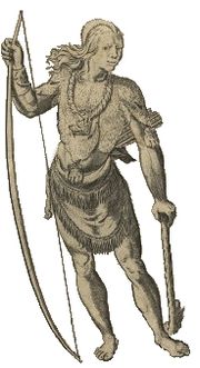
Native Americans in the United States
Native Americans in the United States are the indigenous peoples in North America within the boundaries of the present-day continental United States, parts of Alaska, and the island state of Hawaii. They are composed of numerous, distinct tribes, states, and ethnic groups, many of which survive as...
tribe from West Virginia
West Virginia
West Virginia is a state in the Appalachian and Southeastern regions of the United States, bordered by Virginia to the southeast, Kentucky to the southwest, Ohio to the northwest, Pennsylvania to the northeast and Maryland to the east...
'. In the late 17th century, they lived in the Kanawha Valley, near the Kanawha
Kanawha River
The Kanawha River is a tributary of the Ohio River, approximately 97 mi long, in the U.S. state of West Virginia. The largest inland waterway in West Virginia, it has formed a significant industrial region of the state since the middle of the 19th century.It is formed at the town of Gauley...
and New Rivers.
Name
What the Monetons called themselves is unknown. In the 1670s, Abraham WoodAbraham Wood
Abraham Wood , sometimes referred to as "General" or "Colonel" Wood, was an English fur trader and explorer of 17th century colonial Virginia...
wrote their name "Moneton" and the other variant "Monyton."
Chickamauga wars
The Chickamauga Wars were a series of raids, campaigns, ambushes, minor skirmishes, and several full-scale frontier battles which were a continuation of the Cherokee struggle against encroachment by American frontiersmen from the former British colonies...
. Points from the Blue Ridge Mountains
Blue Ridge Mountains
The Blue Ridge Mountains are a physiographic province of the larger Appalachian Mountains range. This province consists of northern and southern physiographic regions, which divide near the Roanoke River gap. The mountain range is located in the eastern United States, starting at its southern-most...
and Shenandoah River
Shenandoah River
The Shenandoah River is a tributary of the Potomac River, long with two forks approximately long each, in the U.S. states of Virginia and West Virginia...
tributary outcrops have been found near Beckley, West Virginia
Beckley, West Virginia
Beckley is a city in Raleigh County, West Virginia, United States, which was founded on April 4, 1838. The 2008 population was estimated to be 16,832 by the U.S. Census Bureau. Early in its history, the town was known as Beckleyville and Raleigh Court House...
. The eastern slopes of the southern Allegheny Mountains in today's Virginia is traditionally the Mahock
Manahoac
The Manahoac, also recorded as Mahock, were a small group of Siouan-language American Indians in northern Virginia at the time of European contact. They numbered approximately 1,000 and lived primarily along the Rappahannock River west of modern Fredericksburg and the fall line, and east of the...
, and western rim of Tutelo
Tutelo
The Tutelo were Native people living above the Fall Line in present-day Virginia and West Virginia, speaking a Siouan dialect of the Tutelo language thought to be similar to that of their neighbors, the Monacan and Manahoac nations...
and "Monasuccapanough" (1607) Siouan language groups and those of Iroquois dialects
Iroquoian languages
The Iroquoian languages are a First Nation and Native American language family.-Family division:*Ruttenber, Edward Manning. 1992 [1872]. History of the Indian tribes of Hudson's River. Hope Farm Press....
. The Monacan, "Monahassanaugh" (1607).
Kahnawáʼkye in Tuscarora (Iroquois) means "waterway", "kye" is augmentive suffix. Kaniatarowanenneh means "big waterway" in Mohawk (Iroquois).
History
James MooneyJames Mooney
James Mooney was an American ethnographer who lived for several years among the Cherokee. He did major studies of Southeastern Indians, as well as those on the Great Plains...
declared the Moneton lived in the western part of Colonial Virginia and said their name was an eastern Siouan word. Some scholars suggest Monetons were an element of Monacan and a variation of colonial spelling. The phrase Wood writes can be understood a couple of ways and having no surety.
Wood's remarks imply that some of the [sic]"Tomahittons" favored the [sic]"Occheneechees
Occaneechi
The Occaneechi are Native Americans who lived primarily on a large, long Occoneechee Island and east of the confluence of the Dan and Roanoke Rivers, near current day Clarksville, Virginia in the 17th century...
" position in Virginia's Fur Trade
Fur trade
The fur trade is a worldwide industry dealing in the acquisition and sale of animal fur. Since the establishment of world market for in the early modern period furs of boreal, polar and cold temperate mammalian animals have been the most valued...
as middlemen. A small group of Tomahitans tied Arthur, Wood's agent, to the stake to burn him under the instructions of the "Occheneechees". The King of "Tomahittons" arrived, in time, and rescued Arthur, shooting that sub-group's leader. This seems to have put a quick end to the political dispute within the Tomahitan tribe. The Tomahitan tribe did accept members of certain other tribes to live with them as subordinates. Wood's recount of Arthur's travels does yield the Moneton neighbor's of 3 days journey or about 60~90 miles away and much further away if by canoe. This distance is based on the well known explorier surveyors Christopher Gist
Christopher Gist
Christopher Gist was an accomplished American explorer, surveyor and frontiersman. He was one of the first white explorers of the Ohio Country . He is credited with providing the first detailed description of the Ohio Country to Great Britain and her colonists...
's and George Washington
George Washington
George Washington was the dominant military and political leader of the new United States of America from 1775 to 1799. He led the American victory over Great Britain in the American Revolutionary War as commander-in-chief of the Continental Army from 1775 to 1783, and presided over the writing of...
's several journals ability to travel these regions. The Moneton neighbor's shot arrows at Tomahitans on sight, but did not bother themselves to give chase. Alas, this still does not achieve the question, who were the Moneton's?
Gabriel Arthur's visit
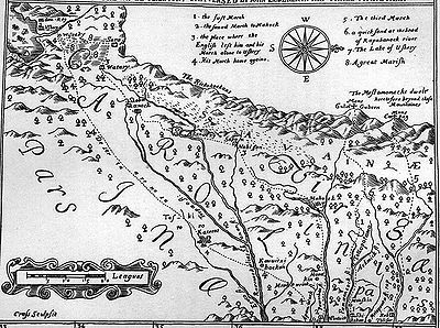
The First Explorations of the Trans-Alleghany Region by the Virginians 1650–1674
"The word Monetons, according to Mooney (letter of January 7, 1909) is Siouan. The identity of the tribe is doubtful. From location and similarity of name they may perhaps be simply the Mohetan of Fallam's journal, and belong to the Cherokee. The Mohetan told Batts and Fallam that their villages were about half-way between Peters' Mountain and the Ohio."— Clarence Walworth Alvord and Lee Bidgood, 1912. Hale & Mooney defines Siouan "Mon", "Ma" and "Man" meaning a people's land otherwise their "country" which by this definition "Mon" does not directly refer to "water", but, to the "area of". Some scholars have pointed out that unlike the other proper nouns, Wood does not capitalize in his printing "monetons" nor the variant, "monytons", another curious observation. "Mone" means water, and "ton" means large according to Robert Rankin, professor emeritus of linguistics at the University of Kansas, Siouan linguistics. Doctor Rankin compared linguistically "the Tutelo of Virginia are more closely related to the Crows of Montana than the Catawbans (of Carolinas)". From very recent study of 9,000 pottery shards from Fort Ancient sites in the Kanawha and Ohio River valleys showed that 37 percent of them bore corncob impressions similar to those produced in the Siouan villages of Virginia between 1400 and 1600 as Charleston Gazette staff writer Rick Steelhammer summarized Darla Spencer of Cultural Resources Analysts, Inc results. "I think Siouan was spoken in the Kanawha Valley," Doctor Rankin concluded at the 2009 WV Archaeology Annual Meeting.Using topographic maps, geographic landmarks and travel distances, Briceland (1987) demonstrates that Batts & Fallam reached Matewan
Matewan, West Virginia
Matewan is a town in Mingo County, West Virginia, USA at the confluence of the Tug Fork River and Mate Creek. The population was 498 at the 2000 census...
on the Tug Fork. There are no known, else discovered, archaeological village sites on this branch. However, using the same method, the local university discussions point to the Guyandotte
Guyandotte River
The Guyandotte River is a tributary of the Ohio River, approximately 166 mi long, in southwestern West Virginia in the United States. It was named after the French term for the Wendat Native Americans...
at the Logan County
Logan County, West Virginia
As of the census of 2000, there were 37,710 people, 14,880 households, and 10,936 families residing in the county. The population density was 83 people per square mile . There were 16,807 housing units at an average density of 37 per square mile...
archaeological village site being Batts & Fallam's farthest reach in exploration. The islands near Logan
Logan, West Virginia
Logan is a city in Logan County, West Virginia, United States, along the Guyandotte River. The population was 1,779 at the 2010 census. It is the county seat of Logan County.-History:...
resembles the falls of the James River
James River
The James River may refer to:Rivers in the United States and their namesakes* James River * James River , North Dakota, South Dakota* James River * James River * James River...
near Wood's Fort in Virginia
Virginia
The Commonwealth of Virginia , is a U.S. state on the Atlantic Coast of the Southern United States. Virginia is nicknamed the "Old Dominion" and sometimes the "Mother of Presidents" after the eight U.S. presidents born there...
. The gravel bar near Matewan, West Virginia
Matewan, West Virginia
Matewan is a town in Mingo County, West Virginia, USA at the confluence of the Tug Fork River and Mate Creek. The population was 498 at the 2000 census...
does not resemble these early descriptions of the village's location of Batts & Fallam. These studies, also, are speculation yet to be proven.
Other of ye inhabitance
Of the unidentified people on the Ohio Valley, Wood writes, "He (Gabriell) made signes to them the gun was ye Tomahittons which he had a disire to take with him, but ye knife and hatchet he gave to ye king. they not knowing ye use of gunns, the king received it with great shewes of thankfullness for they had not any manner of iron instrument that hee saw amongst them ". The reports of this tribe given by the Mohetan to Batts and Fallam correspond with those given to Arthur by the Moneton. Fallam called those on the Great Kanawha RiverKanawha River
The Kanawha River is a tributary of the Ohio River, approximately 97 mi long, in the U.S. state of West Virginia. The largest inland waterway in West Virginia, it has formed a significant industrial region of the state since the middle of the 19th century.It is formed at the town of Gauley...
"Mohetan" and this is perhaps an example of tribal influx. In 1671, Thomas Batts wrote, "We understand the Mohecan Indians did here formerly live. It cannot be long since we found corn stalks in the ground." Batts and Fallam, Wood's agents, are credited as having discovered Kanawha Falls
Glen Ferris, West Virginia
Glen Ferris is an unincorporated census-designated place on the western bank of the Kanawha River in Fayette County, West Virginia. It is situated approximately one mile south of the town of Gauley Bridge. The sole highway linking Glen Ferris to the area is U.S. Route 60, known also as the Midland...
. Ouabano was a band of Mohicans or Eastern Lenape
Lenape
The Lenape are an Algonquian group of Native Americans of the Northeastern Woodlands. They are also called Delaware Indians. As a result of the American Revolutionary War and later Indian removals from the eastern United States, today the main groups live in Canada, where they are enrolled in the...
who lived within the region (Hodge). Mr Batts wrote about what he saw. Earlier scholars have this site as found to be on Campbells Creek near Belle
Belle, West Virginia
Belle is a town in Kanawha County, West Virginia, along the Kanawha River. The population was 1,259 at the 2000 census. Belle was incorporated on December 13, 1958 by the Kanawha County Circuit Court...
. Continued best guess otherwise, there is the archaeological village site at Marmet
Marmet, West Virginia
Marmet is a city in Kanawha County, West Virginia, USA, along the Kanawha River.-Geography:Marmet is located at .According to the United States Census Bureau, the city has a total area of 1.5 square miles , of which, 1.4 square miles of it is land and 0.1 square miles of it is...
which is more likely Gabriel Arthur's visit with the Moneton (Maslowski et al.) and very near Belle.
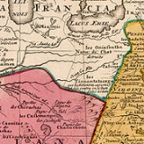
The Iroquois League, Huron Confederacy and Andaste (Sultzman) are well reported as blocking the Nation du Chat from attaining fire arms, the Andaste serving as middlemen to the French and Dutch trade. The Dutch
Netherlands
The Netherlands is a constituent country of the Kingdom of the Netherlands, located mainly in North-West Europe and with several islands in the Caribbean. Mainland Netherlands borders the North Sea to the north and west, Belgium to the south, and Germany to the east, and shares maritime borders...
had provided Andaste with fire arms, another of the League's enemy who also spoke a dialect of Iroquois
Iroquois
The Iroquois , also known as the Haudenosaunee or the "People of the Longhouse", are an association of several tribes of indigenous people of North America...
as did the "Panther People" (corrupted Nation du Chat) otherwise of the Iroquian word "Erielhonan". Their neighbor east, at that time, of the Allegheny Mountains were the late Conestoga (Quaker for Andaste), earlier called Susquehannocks (Virginian). Susquehannocks is first mentioned in the Voyages of Samuel Champlain for 1615 as he calls one of their some 20 villages "Carantouan". It rallied more than 800 warriors with two other villages, Champlain reports. "Carantouan" was nearer to the New York
New York
New York is a state in the Northeastern region of the United States. It is the nation's third most populous state. New York is bordered by New Jersey and Pennsylvania to the south, and by Connecticut, Massachusetts and Vermont to the east...
and Pennsylvania
Pennsylvania
The Commonwealth of Pennsylvania is a U.S. state that is located in the Northeastern and Mid-Atlantic regions of the United States. The state borders Delaware and Maryland to the south, West Virginia to the southwest, Ohio to the west, New York and Ontario, Canada, to the north, and New Jersey to...
border on the tributaries of the Susquehanna River
Susquehanna River
The Susquehanna River is a river located in the northeastern United States. At long, it is the longest river on the American east coast that drains into the Atlantic Ocean, and with its watershed it is the 16th largest river in the United States, and the longest river in the continental United...
on his map approaching towards the region from the Saint Lawrence Seaway
Saint Lawrence Seaway
The Saint Lawrence Seaway , , is the common name for a system of locks, canals and channels that permits ocean-going vessels to travel from the Atlantic Ocean to the North American Great Lakes, as far as Lake Superior. Legally it extends from Montreal to Lake Erie, including the Welland Canal...
. West Virginia's Grant
Grant County, West Virginia
As of the census of 2000, there were 11,299 people, 4,591 households, and 3,273 families residing in the county. The population density was 24 people per square mile . There were 6,105 housing units at an average density of 13 per square mile...
, Hampshire
Hampshire County, West Virginia
Hampshire County is a county located in the U.S. state of West Virginia. As of 2010, the population was 23,964. Its county seat is Romney, West Virginia's oldest town . Hampshire County was created by the Virginia General Assembly on December 13, 1753, from parts of Frederick and Augusta counties ...
and Hardy
Hardy County, West Virginia
As of the census of 2000, there were 12,669 people, 5,204 households, and 3,564 families residing in the county. The population density was 22 people per square mile . There were 7,115 housing units at an average density of 12 per square mile...
counties and Maryland's Allegheny county
Allegany County, Maryland
Allegany County is a county located in the northwestern part of the US state of Maryland. It is part of the Cumberland, MD-WV Metropolitan Statistical Area. As of 2010, the population was 75,087. Its county seat is Cumberland...
region (Brashler 1987) possess archaeological sites having Susquehannock Ceramics. A Susquehanna site is located at Moorefield, West Virginia
Moorefield, West Virginia
Moorefield is a town in Hardy County, West Virginia, USA. Moorefield is the county seat of Hardy County. It was originally chartered in 1777 and named for Conrad Moore, who owned the land upon which the town was laid out...
.
The tribes on the south eastern Allegheny Mountains of West Virginia in a region of the Blue Stone and Greenbrier river tributaries can be found in Batts and Fallows' September, 1671 Expedition. Penecute, an "Apomatack" Indian with seven more additional escorts who were later sent by their leadership, was hired and later a "Sepiny" Indian guide of the Sapony River (Staunton River) was hired to trek towards the "Teteras" (Toteras.) September 12, 1671, a Teteras guide was hired from a village just west of today's Salem, Virginia. It was declared while on the New River at Peters’ Falls, where the New River breaks through Peters’ Mountain, near Pearisburg, Virginia
Pearisburg, Virginia
Pearisburg is a town in Giles County, Virginia, United States. The population was 2,729 at the 2000 census. It is the county seat of Giles County.Pearisburg is part of the Blacksburg–Christiansburg–Radford Metropolitan Statistical Area....
the "Moketans had formerly lived." On the valleys near today's Lewisburg
Lewisburg, West Virginia
Lewisburg is a city in Greenbrier County, West Virginia, United States. The population was 3,830 at the 2010 census. It is the county seat of Greenbrier County.-Geography:Lewisburg is located at ....
and Beckley
Beckley, West Virginia
Beckley is a city in Raleigh County, West Virginia, United States, which was founded on April 4, 1838. The 2008 population was estimated to be 16,832 by the U.S. Census Bureau. Early in its history, the town was known as Beckleyville and Raleigh Court House...
of the West Virginia
West Virginia
West Virginia is a state in the Appalachian and Southeastern regions of the United States, bordered by Virginia to the southeast, Kentucky to the southwest, Ohio to the northwest, Pennsylvania to the northeast and Maryland to the east...
area, "One came ("Apomatack" excort) and told us they heard a Drum and a Gun go off to the northwards..." and some days later they learnt the "Mountain Indians" of the Kanawha Falls
Glen Ferris, West Virginia
Glen Ferris is an unincorporated census-designated place on the western bank of the Kanawha River in Fayette County, West Virginia. It is situated approximately one mile south of the town of Gauley Bridge. The sole highway linking Glen Ferris to the area is U.S. Route 60, known also as the Midland...
("Walnut Gather Place") area already possessed firearms, "...We have found Mehetan Indians who having intelligence of our coming were afraid it had been to fight them and had sent him to the Totera’s to inquire. We have him satisfaction to the contrary and that we came as friends, presented him with three or four shots of powder. He told us by our Interpreter, that we had [been] from the mountains half way to the place they now live at. That the next town beyond them lived on a plain level, from whence came abundance of salt. That he could inform us no further by reason that there were a great company of Indians that lived upon the great Water." It can be surmised these were the arrival of the Les Tionontatacaga or Guyandotte of which namesake is the Guyandotte River
Guyandotte River
The Guyandotte River is a tributary of the Ohio River, approximately 166 mi long, in southwestern West Virginia in the United States. It was named after the French term for the Wendat Native Americans...
in Cabell County
Cabell County, West Virginia
As of the census of 2000, there were 96,784 people, 41,180 households, and 25,490 families residing in the county. The population density was 344 people per square mile . There were 45,615 housing units at an average density of 162 per square mile...
. This journal does not identify the "Salt Village" on the Kanawha, but, that the "Mehetan" were associated with these and apparently not those further down to the Ohio River
Ohio River
The Ohio River is the largest tributary, by volume, of the Mississippi River. At the confluence, the Ohio is even bigger than the Mississippi and, thus, is hydrologically the main stream of the whole river system, including the Allegheny River further upstream...
.
Protohistory
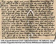
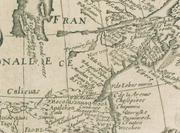
"Les Tionontatacaga" (Guyandottes), shown on Homann Johann Baptist's map of 1710, had taken refuge farther in West Virginia's hollows (after 1701) from the great heat of the Iroquois invasion, the Moneton's territory. "Les Oniassoutlea", dialect variation Oniassontke, shown on the map are otherwise Black Minqua (Dutch) of the Upper Ohio Valley and Honniasontkeronon of the Middle Ohio Valley. Honniasontkeronon "infested the country above the rapids of the Ohio River" as the Seneca told La Salle
René-Robert Cavelier, Sieur de La Salle
René-Robert Cavelier, Sieur de La Salle, or Robert de LaSalle was a French explorer. He explored the Great Lakes region of the United States and Canada, the Mississippi River, and the Gulf of Mexico...
in 1669. They were reported to be hereditary enemies to the Nation of Fire. The Shattera's (Swanton's Toteras element of Tutelo
Tutelo
The Tutelo were Native people living above the Fall Line in present-day Virginia and West Virginia, speaking a Siouan dialect of the Tutelo language thought to be similar to that of their neighbors, the Monacan and Manahoac nations...
) village is shown at Williamson
Williamson, West Virginia
Williamson is a city in Mingo County, West Virginia, USA, along the Tug Fork River. The population was 3,414 at the 2000 census. It is the county seat of Mingo County, and is the county's largest and most populous city. Williamson is home to Southern West Virginia Community and Technical College...
(Tug Fork) according to a letter written to the Lord of Trade, New York
New York
New York is a state in the Northeastern region of the United States. It is the nation's third most populous state. New York is bordered by New Jersey and Pennsylvania to the south, and by Connecticut, Massachusetts and Vermont to the east...
, dated April 13, 1699. E.B. O'Callaghan M.D. also cited this source in his "Colonial History of the State of New York", published at Albany in 1856. There is uncertainty as which stream they migrated at first to near Salem, Virginia
Salem, Virginia
Salem is an independent city in Virginia, USA, bordered by the city of Roanoke to the east but otherwise adjacent to Roanoke County. It is part of the Roanoke Metropolitan Statistical Area. The population was 24,802 according to 2010 U.S. Census...
, either their Big Sandy
Big Sandy River (Ohio River)
The Big Sandy River is a tributary of the Ohio River, approximately long, in western West Virginia and northeastern Kentucky in the United States. The river forms part of the boundary between the two states along its entire course...
(or the Logan site
Guyandotte River
The Guyandotte River is a tributary of the Ohio River, approximately 166 mi long, in southwestern West Virginia in the United States. It was named after the French term for the Wendat Native Americans...
) or the Great Kanawha
Kanawha River
The Kanawha River is a tributary of the Ohio River, approximately 97 mi long, in the U.S. state of West Virginia. The largest inland waterway in West Virginia, it has formed a significant industrial region of the state since the middle of the 19th century.It is formed at the town of Gauley...
rivers. The Big Sandy River
Big Sandy River (Ohio River)
The Big Sandy River is a tributary of the Ohio River, approximately long, in western West Virginia and northeastern Kentucky in the United States. The river forms part of the boundary between the two states along its entire course...
, a border of West Virginia
West Virginia
West Virginia is a state in the Appalachian and Southeastern regions of the United States, bordered by Virginia to the southeast, Kentucky to the southwest, Ohio to the northwest, Pennsylvania to the northeast and Maryland to the east...
and Kentucky
Kentucky
The Commonwealth of Kentucky is a state located in the East Central United States of America. As classified by the United States Census Bureau, Kentucky is a Southern state, more specifically in the East South Central region. Kentucky is one of four U.S. states constituted as a commonwealth...
, was once known as the "Toteroy River" in their memory as shown on early maps.
Anthropologist James B. Griffin
James Bennett Griffin
James Bennett Griffin was an American archaeologist. He is regarded as one of the most influential archaeologists in North America in the 20th century.-Personal life:...
in 1942 concluded, "there is not…any sound historical evidence for believing that the central Ohio Valley was the point of dispersal for the Siouan speaking tribes." Griffin's book On the Historic Location of the Tutelo and the Mohetan in the Ohio Valley is devoted in greater part to the Tutelo. Griffin devotes one paragraph of the Mohetan's east-to-west movement within the area and one sentence about Mosopolea occupation on the Ohio Valley. James Mooney, in a monograph surveying “The Siouan Tribes of the East”, lists Mohetan as one of at least nine groups clearly Siouan. The Occaneechis (Akenatzy, etc.) language was said to be much like Tutelo and a lingua franca or a Virginia trade language. Tutelos and Saponis spoke virtually the same language. The Monyton's language is thought to be similar to Occaneechis while mąnį΄ ‘water’ in Tutelo; anį΄ in Ofo & Biloxi. ithą΄ ‘big, great’ in Tutelo; same in Ofo/Biloxi (Rankin 2009).
Western Virginia "Cherokee" (contemporary "Calicuas") were reported at Cherokee Falls (today's Valley Falls
Valley Falls State Park
Valley Falls State Park is a 1,145 acre day use facility sited along both banks of the Tygart Valley River. The park is located about 7 miles south of exit 137 of I-79, near Fairmont, West Virginia....
) in 1705. Indian trader Charles Poke's trading post dates from 1731 with the remanent Calicuas of Cherokee Falls still in the region from the previous century. "The Monetons are regarded to have been a distant branch of the Cherokees (contemporary "Tomahittons"). They had a natural antipathy for the Shawnees (contemporary "Showanoes"), who were located on both sides of the Ohio in the vicinity of the mouth of the Scioto River
Scioto River
The Scioto River is a river in central and southern Ohio more than 231 miles in length. It rises in Auglaize County in west central Ohio, flows through Columbus, Ohio, where it collects its largest tributary, the Olentangy River, and meets the Ohio River at Portsmouth...
. After terminating their visit with the Monetons the Cherokees went out of their direct path of return for a few days' swing to the westward to take a "clap" at their ancient and formidable enemy, the Shawnees.", quoting the Kentucky Historical Society (1922).
In his book, "History Of The Commonwealth Of Pennsylvania
Pennsylvania
The Commonwealth of Pennsylvania is a U.S. state that is located in the Northeastern and Mid-Atlantic regions of the United States. The state borders Delaware and Maryland to the south, West Virginia to the southwest, Ohio to the west, New York and Ontario, Canada, to the north, and New Jersey to...
", (Harrisburg, 1876) state librarian of Pennsylvania, William H. Egle figured that the Massawomeke is the tribe later known by the name of "Mohawk
Mohawk nation
Mohawk are the most easterly tribe of the Iroquois confederation. They call themselves Kanien'gehaga, people of the place of the flint...
". Much earlier, however, Captain Henry Fleet arrived on the Potomac River after 1623. Later, William Claiborne
William Claiborne
William Claiborne was an English pioneer, surveyor, and an early settler in Virginia and Maryland. Claiborne became a wealthy planter, a trader, and a major figure in the politics of the colony...
, Sir John Wolstenholme
John Wolstenholme
John Wolstenholme was an English cricketer. He was a right-handed batsman and a right-arm medium-fast bowler who played for Northamptonshire....
, Clobery & Company and the Baltimores established a trading post at Kent Island
Kent Island, Maryland
Kent Island is the largest island in the Chesapeake Bay, and a historic place in Maryland. To the east, a narrow channel known as the Kent Narrows barely separates the island from the Delmarva Peninsula, and on the other side, the island is separated from Sandy Point, an area near Annapolis, by...
(1631) on the upper Chesapeake Bay
Chesapeake Bay
The Chesapeake Bay is the largest estuary in the United States. It lies off the Atlantic Ocean, surrounded by Maryland and Virginia. The Chesapeake Bay's drainage basin covers in the District of Columbia and parts of six states: New York, Pennsylvania, Delaware, Maryland, Virginia, and West...
. They hired Fleet familiar with "Anacostia Valley
Anacostia River
The Anacostia River is a river in the Mid Atlantic region of the United States. It flows from Prince George's County in Maryland into Washington, D.C., where it joins with the Washington Channel to empty into the Potomac River at Buzzard Point. It is approximately long...
Naturalls" as a guide and interpreter. Leonard Calvert
Leonard Calvert
Leonard Calvert was the 1st Proprietary Governor of Maryland. He was the second son of George Calvert, 1st Baron Baltimore, the first proprietary of the Province of Maryland...
's letter to Sir Richard Lechford, dated May 30, 1634, "The nation we trade withal at this time a-year is called the Massawomeckes. This nation cometh seven, eight, and ten days journey to us—these are those from whom Kircke (a Canadien
Canada
Canada is a North American country consisting of ten provinces and three territories. Located in the northern part of the continent, it extends from the Atlantic Ocean in the east to the Pacific Ocean in the west, and northward into the Arctic Ocean...
) had formerly all his trade of beaver." John Smith wrote of the Susquehannock, "They can make neere 600 able and mighty men, and are pallisadoed in their Townes to defend them from the Massawomekes their mortall enimies." John Lederer
John Lederer
John Lederer was a 17th-century German physician and an explorer of the Appalachian Mountains. He and the members of his party became the first Europeans to crest the Blue Ridge Mountains and the first to see the Shenandoah Valley and the Allegheny Mountains beyond...
, for colonial governor of Virginia
Virginia
The Commonwealth of Virginia , is a U.S. state on the Atlantic Coast of the Southern United States. Virginia is nicknamed the "Old Dominion" and sometimes the "Mother of Presidents" after the eight U.S. presidents born there...
Sir William Berkeley, made expeditions into the Appalachians between 1669 and 1670 and reached the Mouth of the Kanawha River. With the Cherokee Nation
Cherokee Nation
The Cherokee Nation is the largest of three Cherokee federally recognized tribes in the United States. It was established in the 20th century, and includes people descended from members of the old Cherokee Nation who relocated voluntarily from the Southeast to Indian Territory and Cherokees who...
, he reported no hostilities on the Kanawha Valley
Kanawha River
The Kanawha River is a tributary of the Ohio River, approximately 97 mi long, in the U.S. state of West Virginia. The largest inland waterway in West Virginia, it has formed a significant industrial region of the state since the middle of the 19th century.It is formed at the town of Gauley...
. He settled in the Maryland
Maryland
Maryland is a U.S. state located in the Mid Atlantic region of the United States, bordering Virginia, West Virginia, and the District of Columbia to its south and west; Pennsylvania to its north; and Delaware to its east...
area and traveled to the upper reaches of the Potomac River
Potomac River
The Potomac River flows into the Chesapeake Bay, located along the mid-Atlantic coast of the United States. The river is approximately long, with a drainage area of about 14,700 square miles...
of today's Mineral County, West Virginia
Mineral County, West Virginia
Mineral County is a county located in the U.S. state of West Virginia. It is part of the Cumberland, MD-WV Metropolitan Statistical Area. As of 2010, the population was 28,212. Its county seat is Keyser.-Ancient history:...
. This was a major trade route of the "Massawomeck". Like the other mysterious protohistoric people of the region, identifying the Massawomecks is a best educated guess due to lack of solid documentation. The Powhatan called the Iroquois the Massawomeck (Sultzman). Virginia's Native Americans said of these, "People beyond the Mountains."
Summary
"One of the big myths in West Virginia is the association of Fort Ancient sites with the Shawnee," said Robert Maslowski. "Among cultural differences between the Fort Ancient people and the Shawnee are burial practices." He added, "The Fort Ancient people lived in villages surrounded by log stockades while the Shawnee lived in non-fortified, widely dispersed sites throughout the east." The Tomahitans houses were built within log stockaded villages. The Tomahitans King, himself, clearly calls the Monetons the derivative people of the "Great Water". Growing consensus says the Monetons of West Virginia were culturally similar to Virginia's Monacan and TuteloTutelo
The Tutelo were Native people living above the Fall Line in present-day Virginia and West Virginia, speaking a Siouan dialect of the Tutelo language thought to be similar to that of their neighbors, the Monacan and Manahoac nations...
.
See also
- History of West VirginiaHistory of West VirginiaWest Virginia is one of two American states formed during the American Civil War , along with Nevada, and is the only state to form by seceding from a Confederate state...
- Prehistory of West Virginia
- Protohistory of West VirginiaProtohistory of West VirginiaThe protohistoric period of the US state of West Virginia begins in the mid 16th century with the arrival of European trade goods originating with explorers and colonists on the eastern and southern coasts and being brought inland by native trade routes...
- West Virginia WaterwaysWest Virginia WaterwaysWest Virginia waterways find their highest sources in the highland watersheds of the Allegheny Mountains. These watersheds supply drainage to the creeks often passing through deep and narrow hollows. From the hollows, rushing highland streams collect in bottom land brooks and rivers...