

Kentucky River
Encyclopedia
The Kentucky River is a tributary of the Ohio River
, 260 miles (418 km) long, in the U.S. state
of Kentucky
. The river and its tributaries drain much of the central region of the state, with its upper course passing through the coal
-mining
regions of the Cumberland Mountains
, and its lower course passing through the Bluegrass region
in the north central part of the state. Its watershed encompasses about 7000 square miles (18,129.9 km²). It supplies drinking water to about one-sixth of the population of the state.
The river is no longer navigable above Lock 4 at Frankfort
. Concrete bulkheads have been poured behind the upper lock gates of Locks 5-14 to strengthen the weakest link in the dam structures. All 14 dams are now under the management of the state-run Kentucky River Authority
. The primary importance of the locks today is to maintain a pool that allows the city of Lexington
to draw its drinking water from the river. Despite the fact that the Lexington area receives well over 40 inches (101.6 cm) of precipitation annually, the limestone
, karst
geology
of that area means that surprisingly little natural surface water is found in the region.
Beattyville
, Irvine
, Richmond
, Lancaster
, Nicholasville
, Harrodsburg
, Wilmore
, Versailles
, Lawrenceburg
, and Frankfort also draw water from the river for their municipal water supplies. It is estimated that over 700,000 people depend on the river for water.
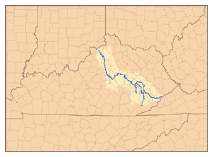 The Kentucky River is formed in eastern Kentucky at Beattyville
, in Lee County
, by the confluence of the North, Middle and South Forks at about 670 feet (204.2 m) elevation, and flows generally northwest, in a highly meander
ing course through the mountains, through the Daniel Boone National Forest
, then past Irvine
and Boonesborough
, then southwest, passing south of Lexington, then north through Frankfort
. It joins the Ohio at Carrollton
.
Approximately 15 miles (24.1 km) southwest of Boonesborough it is joined by the Red River
. Approximately 20 miles (32.2 km) southwest of Boonesborough it is joined by Silver Creek
. At High Bridge
, it is joined by the Dix River
. At Frankfort, it is joined by Benson Creek. Approximately 10 miles (16.1 km) north of Frankfort, it is joined by Elkhorn Creek
.
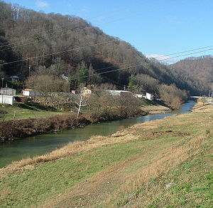
Between Clays Ferry in Madison County
and Frankfort, the river passes through the Kentucky River Palisades
, a series of dramatic steep gorges approximately 100 miles (160.9 km) in length.
It continues on till it flows into the Ohio River at Carrollton in Carroll County.
According to Robert F. Collins of the United States Forest Service
, Dr. Thomas Walker
named the river the Louisa River in 1750, after Princess Louisa, the wife of Prince William, Duke of Cumberland (Walker had just named the Cumberland River
a month or two earlier). Over time the name Louisa became Levisa and shifted to the nearby stream today called the Levisa Fork.
 The North Fork Kentucky River is approximately 168 miles (270.4 km) long. It rises on the western side of Pine Mountain, in the Appalachians
of extreme southeastern Kentucky, in eastern Letcher County
near the Virginia
state line. It flows generally northwest, in a winding course through the mountainous Cumberland Plateau
, past Hazard
and Jackson
. It receives Rockhouse Creek at Blackey
near its source. Approximately 8 miles (13 km) southeast of Hazard, it receives the Carr Fork. It receives Troublesome Creek at Haddix, southeast of Jackson. Three miles upstream from its confluence with the South Fork, it receives the Middle Fork. It joins the South Fork to form the Kentucky at Beattyville
.
in southernmost Leslie County
, approximately 16 miles (25.7 km) from the Virginia
state line, and flows north through the Cumberland Plateau
past Hyden
. At Buckhorn
, it is impounded to form the Buckhorn Lake reservoir. North of the reservoir it flows generally northwest and joins the North Fork in Lee County
, approximately 5 miles (8 km) east of the confluence of the North and South forks at Beattyville
.
, at the town of Oneida
in the Daniel Boone National Forest
, approximately 10 miles (16 km) northeast of Manchester
, by the confluence of Goose Creek and the Red Bird River
. It flows generally north in a highly meander
ing course through the mountainous Cumberland Plateau
region. It joins the North Fork to form the Kentucky at Beattyville
.
ever taken in the state of Kentucky (2 lbs, .64 oz.) was caught in the Kentucky River.
Ohio River
The Ohio River is the largest tributary, by volume, of the Mississippi River. At the confluence, the Ohio is even bigger than the Mississippi and, thus, is hydrologically the main stream of the whole river system, including the Allegheny River further upstream...
, 260 miles (418 km) long, in the U.S. state
U.S. state
A U.S. state is any one of the 50 federated states of the United States of America that share sovereignty with the federal government. Because of this shared sovereignty, an American is a citizen both of the federal entity and of his or her state of domicile. Four states use the official title of...
of Kentucky
Kentucky
The Commonwealth of Kentucky is a state located in the East Central United States of America. As classified by the United States Census Bureau, Kentucky is a Southern state, more specifically in the East South Central region. Kentucky is one of four U.S. states constituted as a commonwealth...
. The river and its tributaries drain much of the central region of the state, with its upper course passing through the coal
Coal
Coal is a combustible black or brownish-black sedimentary rock usually occurring in rock strata in layers or veins called coal beds or coal seams. The harder forms, such as anthracite coal, can be regarded as metamorphic rock because of later exposure to elevated temperature and pressure...
-mining
Mining
Mining is the extraction of valuable minerals or other geological materials from the earth, from an ore body, vein or seam. The term also includes the removal of soil. Materials recovered by mining include base metals, precious metals, iron, uranium, coal, diamonds, limestone, oil shale, rock...
regions of the Cumberland Mountains
Cumberland Mountains
The Cumberland Mountains are a mountain range in the southeastern section of the Appalachian Mountains. They are located in southern West Virginia, western Virginia, eastern edges of Kentucky, and eastern middle Tennessee, including the Crab Orchard Mountains...
, and its lower course passing through the Bluegrass region
Bluegrass region
The Bluegrass Region is a geographic region in the state of Kentucky, United States. It occupies the northern part of the state and since European settlement has contained a majority of the state's population and its largest cities....
in the north central part of the state. Its watershed encompasses about 7000 square miles (18,129.9 km²). It supplies drinking water to about one-sixth of the population of the state.
The river is no longer navigable above Lock 4 at Frankfort
Frankfort, Kentucky
Frankfort is a city in Kentucky that serves as the state capital and the county seat of Franklin County. The population was 27,741 at the 2000 census; by population it is the 5th smallest state capital in the United States...
. Concrete bulkheads have been poured behind the upper lock gates of Locks 5-14 to strengthen the weakest link in the dam structures. All 14 dams are now under the management of the state-run Kentucky River Authority
Kentucky River Authority
The Kentucky River Authority is an agency of the Commonwealth of Kentucky. Its major purpose is to operate and maintain a set of locks and dams along the course of the Kentucky River which was originally built by the U.S. Army Corps of Engineers and are now in the process of being deeded over to...
. The primary importance of the locks today is to maintain a pool that allows the city of Lexington
Lexington, Kentucky
Lexington is the second-largest city in Kentucky and the 63rd largest in the US. Known as the "Thoroughbred City" and the "Horse Capital of the World", it is located in the heart of Kentucky's Bluegrass region...
to draw its drinking water from the river. Despite the fact that the Lexington area receives well over 40 inches (101.6 cm) of precipitation annually, the limestone
Limestone
Limestone is a sedimentary rock composed largely of the minerals calcite and aragonite, which are different crystal forms of calcium carbonate . Many limestones are composed from skeletal fragments of marine organisms such as coral or foraminifera....
, karst
KARST
Kilometer-square Area Radio Synthesis Telescope is a Chinese telescope project to which FAST is a forerunner. KARST is a set of large spherical reflectors on karst landforms, which are bowlshaped limestone sinkholes named after the Kras region in Slovenia and Northern Italy. It will consist of...
geology
Geology
Geology is the science comprising the study of solid Earth, the rocks of which it is composed, and the processes by which it evolves. Geology gives insight into the history of the Earth, as it provides the primary evidence for plate tectonics, the evolutionary history of life, and past climates...
of that area means that surprisingly little natural surface water is found in the region.
Beattyville
Beattyville, Kentucky
As of the census of 2000, there were 1,193 people, 509 households, and 294 families residing in the city. The population density was 599.6 people per square mile . There were 561 housing units at an average density of 282.0 per square mile . The racial makeup of the city was 98.99% White, 0.42%...
, Irvine
Irvine, Kentucky
Irvine is a city in and county seat of Estill County, Kentucky, United States. Its population was 2,843 at the 2000 census. It is located on the Kentucky River at the junction of Kentucky Route 52 and Kentucky Route 89....
, Richmond
Richmond, Kentucky
There were 10,795 households out of which 24.4% had children under the age of 18 living with them, 35.2% were married couples living together, 12.8% had a female householder with no husband present, and 48.6% were non-families. Of all households, 34.7% were made up of individuals and 8.8% had...
, Lancaster
Lancaster, Kentucky
Lancaster is a city in Garrard County, Kentucky, in the United States. As of the 2000 census, the city population was 3,734. It is the county seat of Garrard County. Located south of Lexington, it is the site of the Kennedy House, said to have been used in Uncle Tom's Cabin. The controversial...
, Nicholasville
Nicholasville, Kentucky
Nicholasville is the 11th largest city in state of Kentucky and the county seat of Jessamine County, Kentucky, United States. The population was 19,680 at the 2000 census...
, Harrodsburg
Harrodsburg, Kentucky
Harrodsburg is a city in and the county seat of Mercer County, Kentucky, United States. The population was 8,014 at the 2000 census. It is the oldest city in Kentucky.-History:...
, Wilmore
Wilmore, Kentucky
Wilmore is a city in Jessamine County, Kentucky, United States. The population was 6,134 at the 2010 census. It is part of the Lexington–Fayette Metropolitan Statistical Area...
, Versailles
Versailles, Kentucky
As of the census of 2000, there were 7,511 people, 3,160 households, and 2,110 families residing in the city. The population density was . There were 3,330 housing units at an average density of . The racial makeup of the city was 88.18% White, 8.67% African American, 0.15% Native American, 0.35%...
, Lawrenceburg
Lawrenceburg, Kentucky
Lawrenceburg is a city in Anderson County, Kentucky, United States. The population was 10,505 at the 2010 census. It is the county seat of Anderson County...
, and Frankfort also draw water from the river for their municipal water supplies. It is estimated that over 700,000 people depend on the river for water.
Description
Beattyville, Kentucky
As of the census of 2000, there were 1,193 people, 509 households, and 294 families residing in the city. The population density was 599.6 people per square mile . There were 561 housing units at an average density of 282.0 per square mile . The racial makeup of the city was 98.99% White, 0.42%...
, in Lee County
Lee County, Kentucky
Lee County is a county located in the U.S. state of Kentucky. As of 2000, the population was 7,916. Its county seat is Beattyville. It is a prohibition or dry county.-History:...
, by the confluence of the North, Middle and South Forks at about 670 feet (204.2 m) elevation, and flows generally northwest, in a highly meander
Meander
A meander in general is a bend in a sinuous watercourse. A meander is formed when the moving water in a stream erodes the outer banks and widens its valley. A stream of any volume may assume a meandering course, alternately eroding sediments from the outside of a bend and depositing them on the...
ing course through the mountains, through the Daniel Boone National Forest
Daniel Boone National Forest
Daniel Boone National Forest is the only national forest completely within the boundary of Kentucky. Established in 1937, it was originally named the Cumberland National Forest, after the core region called the Cumberland Purchase Unit...
, then past Irvine
Irvine, Kentucky
Irvine is a city in and county seat of Estill County, Kentucky, United States. Its population was 2,843 at the 2000 census. It is located on the Kentucky River at the junction of Kentucky Route 52 and Kentucky Route 89....
and Boonesborough
Boonesborough, Kentucky
Boonesborough is an unincorporated community in Madison County, Kentucky, United States. It lies in the central part of the state along the Kentucky River. Boonesborough is part of the Richmond–Berea Micropolitan Statistical Area....
, then southwest, passing south of Lexington, then north through Frankfort
Frankfort, Kentucky
Frankfort is a city in Kentucky that serves as the state capital and the county seat of Franklin County. The population was 27,741 at the 2000 census; by population it is the 5th smallest state capital in the United States...
. It joins the Ohio at Carrollton
Carrollton, Kentucky
Carrollton is a town in Carroll County, Kentucky, at the confluence of the Ohio River and the Kentucky River. Its population was 3,846 at the 2000 census. It is the county seat of Carroll County....
.
Approximately 15 miles (24.1 km) southwest of Boonesborough it is joined by the Red River
Red River (Kentucky)
The Red River is a tributary of the Kentucky River in east-central Kentucky in the United States. Via the Kentucky and Ohio rivers, it is part of the Mississippi River watershed....
. Approximately 20 miles (32.2 km) southwest of Boonesborough it is joined by Silver Creek
Silver Creek (Kentucky)
Silver Creek is a large creek that flows for approximately through Madison County, Kentucky, in the United States.The creek's depth varies from a few inches to over at normal water levels. Its headwaters are located south of Berea. It reaches its terminus northwest of Richmond at the Kentucky...
. At High Bridge
High Bridge, Kentucky
High Bridge is a small unincorporated community in Jessamine County, Kentucky, United States. It lies along the lower reaches of the Kentucky River near the confluence of the Dix River with the Kentucky...
, it is joined by the Dix River
Dix River
The Dix River is a tributary of the Kentucky River in central Kentucky in the United States.It begins in western Rockcastle County, about west of Mount Vernon. It flows generally northwest, in a tight meandering course, passing north of Stanford and east of Danville. Northwest of Danville it is...
. At Frankfort, it is joined by Benson Creek. Approximately 10 miles (16.1 km) north of Frankfort, it is joined by Elkhorn Creek
Elkhorn Creek
Elkhorn Creek is an stream running through several counties in central Kentucky in the United States. It derives its name from the shape, as seen on a map, of its main stem with its two primary forks....
.
Between Clays Ferry in Madison County
Madison County, Kentucky
Madison County is a county located in the U.S. state of Kentucky. As of 2008, the population was 82,192. Its county seat is Richmond. The county is named for Virginia statesman James Madison, who later became the fourth President of the United States. This is also where famous pioneer Daniel...
and Frankfort, the river passes through the Kentucky River Palisades
Kentucky River Palisades
The Kentucky River Palisades are a series of steep, scenic gorges and limestone outcroppings that stretch for approximately 100 mi , along the Kentucky River in central Kentucky in the United States....
, a series of dramatic steep gorges approximately 100 miles (160.9 km) in length.
It continues on till it flows into the Ohio River at Carrollton in Carroll County.
According to Robert F. Collins of the United States Forest Service
United States Forest Service
The United States Forest Service is an agency of the United States Department of Agriculture that administers the nation's 155 national forests and 20 national grasslands, which encompass...
, Dr. Thomas Walker
Thomas Walker (explorer)
Dr. Thomas Walker was a physician and explorer from Virginia who led an expedition to what is now the region beyond the Allegheny Mountains area of British North America in the mid-18th century...
named the river the Louisa River in 1750, after Princess Louisa, the wife of Prince William, Duke of Cumberland (Walker had just named the Cumberland River
Cumberland River
The Cumberland River is a waterway in the Southern United States. It is long. It starts in Harlan County in far southeastern Kentucky between Pine and Cumberland mountains, flows through southern Kentucky, crosses into northern Tennessee, and then curves back up into western Kentucky before...
a month or two earlier). Over time the name Louisa became Levisa and shifted to the nearby stream today called the Levisa Fork.
North Fork
Appalachian Mountains
The Appalachian Mountains #Whether the stressed vowel is or ,#Whether the "ch" is pronounced as a fricative or an affricate , and#Whether the final vowel is the monophthong or the diphthong .), often called the Appalachians, are a system of mountains in eastern North America. The Appalachians...
of extreme southeastern Kentucky, in eastern Letcher County
Letcher County, Kentucky
Letcher County is a county located in the U.S. state of Kentucky. As of 2000, the population was 25,277. Its county seat is Whitesburg. The county is named for Robert P...
near the Virginia
Virginia
The Commonwealth of Virginia , is a U.S. state on the Atlantic Coast of the Southern United States. Virginia is nicknamed the "Old Dominion" and sometimes the "Mother of Presidents" after the eight U.S. presidents born there...
state line. It flows generally northwest, in a winding course through the mountainous Cumberland Plateau
Cumberland Plateau
The Cumberland Plateau is the southern part of the Appalachian Plateau. It includes much of eastern Kentucky and western West Virginia, part of Tennessee, and a small portion of northern Alabama and northwest Georgia . The terms "Allegheny Plateau" and the "Cumberland Plateau" both refer to the...
, past Hazard
Hazard, Kentucky
As of the census of 2000, there were 4,806 people, 1,946 households, and 1,266 families residing in the city. The population density was 684.6 people per square mile . There were 2,291 housing units at an average density of 326.4 per square mile...
and Jackson
Jackson, Kentucky
There were 1,005 households out of which 28.9% had children under the age of 18 living with them, 44.4% were married couples living together, 18.2% had a female householder with no husband present, and 34.2% were non-families. 31.4% of all households were made up of individuals and 12.3% had...
. It receives Rockhouse Creek at Blackey
Blackey, Kentucky
As of the census of 2000, there were 153 people, 65 households, and 49 families residing in the city. The population density was 314.6 people per square mile . There were 73 housing units at an average density of 150.1 per square mile...
near its source. Approximately 8 miles (13 km) southeast of Hazard, it receives the Carr Fork. It receives Troublesome Creek at Haddix, southeast of Jackson. Three miles upstream from its confluence with the South Fork, it receives the Middle Fork. It joins the South Fork to form the Kentucky at Beattyville
Beattyville, Kentucky
As of the census of 2000, there were 1,193 people, 509 households, and 294 families residing in the city. The population density was 599.6 people per square mile . There were 561 housing units at an average density of 282.0 per square mile . The racial makeup of the city was 98.99% White, 0.42%...
.
Middle Fork
The Middle Fork Kentucky River is a tributary of the North Fork Kentucky River, approximately 105 miles (169 km) long, in southeastern Kentucky. It rises in the Appalachian MountainsAppalachian Mountains
The Appalachian Mountains #Whether the stressed vowel is or ,#Whether the "ch" is pronounced as a fricative or an affricate , and#Whether the final vowel is the monophthong or the diphthong .), often called the Appalachians, are a system of mountains in eastern North America. The Appalachians...
in southernmost Leslie County
Leslie County, Kentucky
Leslie County is a county located in the U.S. state of Kentucky. As of 2000, the population was 12,401. Its county seat is Hyden. The county is named for Preston H. Leslie, Governor of Kentucky...
, approximately 16 miles (25.7 km) from the Virginia
Virginia
The Commonwealth of Virginia , is a U.S. state on the Atlantic Coast of the Southern United States. Virginia is nicknamed the "Old Dominion" and sometimes the "Mother of Presidents" after the eight U.S. presidents born there...
state line, and flows north through the Cumberland Plateau
Cumberland Plateau
The Cumberland Plateau is the southern part of the Appalachian Plateau. It includes much of eastern Kentucky and western West Virginia, part of Tennessee, and a small portion of northern Alabama and northwest Georgia . The terms "Allegheny Plateau" and the "Cumberland Plateau" both refer to the...
past Hyden
Hyden, Kentucky
Hyden is a city in Leslie County, Kentucky, United States. The population was 365 at the 2010 census. It is the county seat of Leslie County. It is located at the junction of U.S. Route 421 and Kentucky Route 80, along the Middle Fork of the Kentucky River....
. At Buckhorn
Buckhorn, Kentucky
As of the census of 2000, there were 144 people, 48 households, and 33 families residing in the city. The population density was 289.4 people per square mile . There were 51 housing units at an average density of 102.5 per square mile...
, it is impounded to form the Buckhorn Lake reservoir. North of the reservoir it flows generally northwest and joins the North Fork in Lee County
Lee County, Kentucky
Lee County is a county located in the U.S. state of Kentucky. As of 2000, the population was 7,916. Its county seat is Beattyville. It is a prohibition or dry county.-History:...
, approximately 5 miles (8 km) east of the confluence of the North and South forks at Beattyville
Beattyville, Kentucky
As of the census of 2000, there were 1,193 people, 509 households, and 294 families residing in the city. The population density was 599.6 people per square mile . There were 561 housing units at an average density of 282.0 per square mile . The racial makeup of the city was 98.99% White, 0.42%...
.
South Fork
The South Fork Kentucky River is approximately 45 miles (72.4 km) long. It is formed in Clay CountyClay County, Kentucky
- Demographics :As of the census of 2011, there were 21,000 people, 8,556 households, and 6,442 families residing in the county. The population density was 52 people per square mile . There were 9,439 housing units at an average density of 20 per square mile...
, at the town of Oneida
Oneida, Kentucky
Oneida is an unincorporated community in Clay County, Kentucky, United States. It is the home of Oneida Baptist Institute. Goose Creek and the Red Bird River confluence to form the South Fork of the Kentucky River just a few hundred yards from the center of the town.The major road that leads from...
in the Daniel Boone National Forest
Daniel Boone National Forest
Daniel Boone National Forest is the only national forest completely within the boundary of Kentucky. Established in 1937, it was originally named the Cumberland National Forest, after the core region called the Cumberland Purchase Unit...
, approximately 10 miles (16 km) northeast of Manchester
Manchester, Kentucky
As of the census of 2000, there were 1,738 people, 778 households, and 455 families residing in the city. The population density was 1,148.4 people per square mile . There were 844 housing units at an average density of 557.7 per square mile...
, by the confluence of Goose Creek and the Red Bird River
Red Bird River
The Red Bird River is a tributary of the South Fork Kentucky River, located in the Daniel Boone National Forest in extreme southeastern Kentucky.-Course:...
. It flows generally north in a highly meander
Meander
A meander in general is a bend in a sinuous watercourse. A meander is formed when the moving water in a stream erodes the outer banks and widens its valley. A stream of any volume may assume a meandering course, alternately eroding sediments from the outside of a bend and depositing them on the...
ing course through the mountainous Cumberland Plateau
Cumberland Plateau
The Cumberland Plateau is the southern part of the Appalachian Plateau. It includes much of eastern Kentucky and western West Virginia, part of Tennessee, and a small portion of northern Alabama and northwest Georgia . The terms "Allegheny Plateau" and the "Cumberland Plateau" both refer to the...
region. It joins the North Fork to form the Kentucky at Beattyville
Beattyville, Kentucky
As of the census of 2000, there were 1,193 people, 509 households, and 294 families residing in the city. The population density was 599.6 people per square mile . There were 561 housing units at an average density of 282.0 per square mile . The racial makeup of the city was 98.99% White, 0.42%...
.
Recreation
The largest goldeyeGoldeye
The goldeye, Hiodon alosoides, is a species of fish in the mooneye family . It occurs from as far down the Mackenzie River as Aklavik in the north to Mississippi in the south, and from Alberta in the west to Ohio south of the Great Lakes, with an isolated population south of James Bay. It is...
ever taken in the state of Kentucky (2 lbs, .64 oz.) was caught in the Kentucky River.