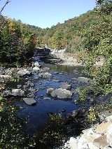
The
Tygart Valley River — also known as the
Tygart River — is a principal
tributaryA tributary or affluent is a stream or river that flows into a main stem river or a lake. A tributary does not flow directly into a sea or ocean...
of the
Monongahela RiverThe Monongahela River is a river on the Allegheny Plateau in north-central West Virginia and southwestern Pennsylvania in the United States...
, approximately 135 miles (217.3 km) long, in east-central
West VirginiaWest Virginia is a state in the Appalachian and Southeastern regions of the United States, bordered by Virginia to the southeast, Kentucky to the southwest, Ohio to the northwest, Pennsylvania to the northeast and Maryland to the east...
, USA. Via the Monongahela and
OhioThe Ohio River is the largest tributary, by volume, of the Mississippi River. At the confluence, the Ohio is even bigger than the Mississippi and, thus, is hydrologically the main stream of the whole river system, including the Allegheny River further upstream...
rivers, it is part of the
watershedA drainage basin is an extent or an area of land where surface water from rain and melting snow or ice converges to a single point, usually the exit of the basin, where the waters join another waterbody, such as a river, lake, reservoir, estuary, wetland, sea, or ocean...
of the
Mississippi RiverThe Mississippi River is the largest river system in North America. Flowing entirely in the United States, this river rises in western Minnesota and meanders slowly southwards for to the Mississippi River Delta at the Gulf of Mexico. With its many tributaries, the Mississippi's watershed drains...
, draining an area of 1329 square miles (3,442.1 km²) in the
Allegheny MountainsThe Allegheny Mountain Range , also spelled Alleghany, Allegany and, informally, the Alleghenies, is part of the vast Appalachian Mountain Range of the eastern United States and Canada...
and the unglaciated portion of the
Allegheny PlateauThe Allegheny Plateau is a large dissected plateau area in western and central New York, northern and western Pennsylvania, northern and western West Virginia, and eastern Ohio...
.
Course
The Tygart Valley River rises in the
Allegheny MountainsThe Allegheny Mountain Range , also spelled Alleghany, Allegany and, informally, the Alleghenies, is part of the vast Appalachian Mountain Range of the eastern United States and Canada...
in
Pocahontas CountyAs of the census of 2000, there were 9,131 people, 835 households, and 527 families residing in the county. The population density was 10 people per square mile . There were 7,594 housing units at an average density of 8 per square mile...
and flows generally north-northwestwardly through
RandolphAs of the census of 2000, there were 28,262 people, 11,072 households, and 7,661 families residing in the county. The population density was 27 people per square mile . There were 13,478 housing units at an average density of 13 per square mile...
,
BarbourAs of the census of 2000, there are 15,557 people, 6,123 households, and 4,365 families residing in the county. The population density is 46 people per square mile . There are 7,348 housing units at an average density of 22 per square mile...
,
TaylorAs of the census of 2000, there were 16,089 people, 6,320 households, and 4,487 families residing in the county. The population density was 93 people per square mile . There were 7,125 housing units at an average density of 41 per square mile...
and
Marion| style="float:right;"|As of the census of 2000, there were 56,598 people, 23,652 households, and 15,515 families residing in the county. The population density was 183 people per square mile . There were 26,660 housing units at an average density of 86 per square mile...
counties, past the towns of
HuttonsvilleHuttonsville is a town in Randolph County, West Virginia, United States, along the Tygart Valley River. The population was 217 at the 2000 census.-History:...
,
Mill CreekMill Creek is a town in Randolph County, West Virginia, United States, along the Tygart Valley River. The population was 662 at the 2000 census.-Geography:Mill Creek is located at ....
,
BeverlyBeverly is a small town in Randolph County, West Virginia, USA. It is situated along the Tygart Valley River and had a population of 651 at the 2000 census.-Geography:Beverly is located at ....
,
ElkinsElkins is a city in Randolph County, West Virginia, United States. The community was incorporated in 1890 and named in honor of Stephen Benton Elkins , a U.S. Senator from West Virginia. The population was 7,032 at the 2000 census. It is the county seat of Randolph County...
,
JuniorJunior is a town in Barbour County, West Virginia in the USA, along the Tygart Valley River. The population was 450 at the 2000 census.-Geography:Junior is located at ....
,
BelingtonBelington is a City in Barbour County, West Virginia, along the Tygart Valley River. The population was 1,788 as of the 2000 census.-Geography:Belington is located at ....
,
PhilippiPhilippi is a city in — and the county seat of — Barbour County, West Virginia, USA. The population was 2,870 at the 2000 census. In 1861, the city was the site of the Battle of Philippi, known as "The Philippi Races"...
,
ArdenArden is a small unincorporated community located along the Tygart Valley River in Barbour County in the north central portion of the U.S. state of West Virginia....
, and
GraftonGrafton is a city in, and county seat of, Taylor County, West Virginia, USA. The population was 5,489 at the 2000 census. The only two national cemeteries in West Virginia are located in Grafton. Mother's Day was founded in Grafton on May 10, 1908; the city is the home to the International Mother's...
, to
FairmontFairmont is a city in Marion County, West Virginia, United States. Nicknamed "The Friendly City". The population was 18,704 at the 2010 census...
, where it joins the
West Fork RiverThe West Fork River is a principal tributary of the Monongahela River, 103 miles long, in north-central West Virginia in the United States...
to form the
Monongahela RiverThe Monongahela River is a river on the Allegheny Plateau in north-central West Virginia and southwestern Pennsylvania in the United States...
. Downstream of Elkins, the Tygart Valley River passes through a
gapA mountain pass is a route through a mountain range or over a ridge. If following the lowest possible route, a pass is locally the highest point on that route...
between Rich Mountain and
Laurel MountainFor other "Laurel Mountains", see Laurel Mountain .Laurel Mountain, also called Laurel Hill, is a long ridge in north-central West Virginia, USA...
, which are considered to be part of the westernmost ridge of the Allegheny Mountains and the boundary between the Alleghenies and the Allegheny Plateau.
Along its course the river collects
Leading CreekLeading Creek is a tributary of the Tygart Valley River, long, in eastern West Virginia in the United States. Via the Tygart Valley, Monongahela and Ohio rivers, it is part of the watershed of the Mississippi River, draining an area of in the Allegheny Mountains...
at Elkins; the
Middle Fork RiverThe Middle Fork River is a tributary of the Tygart Valley River in north-central West Virginia, USA. Via the Tygart Valley, Monongahela and Ohio rivers, it is part of the watershed of the Mississippi River, draining an area of on the easternmost part of the unglaciated portion of the Allegheny...
and the
Buckhannon RiverThe Buckhannon River is a tributary of the Tygart Valley River in north-central West Virginia, USA. Via the Tygart Valley, Monongahela and Ohio rivers, it is part of the watershed of the Mississippi River, draining an area of on the unglaciated portion of the Allegheny Plateau...
(its largest tributary) in Barbour County; and Sandy Creek and Three Fork Creek in Taylor County. Just upstream of Grafton, the river was impounded by a U.S. Army Corps of Engineers
damA dam is a barrier that impounds water or underground streams. Dams generally serve the primary purpose of retaining water, while other structures such as floodgates or levees are used to manage or prevent water flow into specific land regions. Hydropower and pumped-storage hydroelectricity are...
in 1938 to form Tygart Lake.
Valley Falls State ParkValley Falls State Park is a 1,145 acre day use facility sited along both banks of the Tygart Valley River. The park is located about 7 miles south of exit 137 of I-79, near Fairmont, West Virginia....
is along the river between Grafton and Fairmont.
Flow rate
At the
United States Geological SurveyThe United States Geological Survey is a scientific agency of the United States government. The scientists of the USGS study the landscape of the United States, its natural resources, and the natural hazards that threaten it. The organization has four major science disciplines, concerning biology,...
's
stream gaugeA stream gauge, stream gage or gauging station is a location used by hydrologists or environmental scientists to monitor and test terrestrial bodies of water. Hydrometric measurements of water surface elevation and/or volumetric discharge are generally taken and observations of biota may also be...
in Philippi, the annual mean flow of the river between 1940 and 2005 was 1,922 ft³/s (54 m³/s). The river's highest flow during the period was estimated at 61,000 ft³/s (1,727 m³/s) on November 5, 1985. The lowest recorded flow was 4.9 ft³/s (0.1 m³/s) on several days in October 1953.
At an upstream gauge near the community of
DaileyDailey is an unincorporated census-designated place in Randolph County, West Virginia, United States. Dailey is located on U.S. Route 219 and U.S. Route 250 south-southwest of Beverly. Dailey has a post office with ZIP code 26259...
in Randolph County, the annual mean flow of the river between 1915 and 2005 was 358 ft³/s (10 m³/s). The highest recorded flow during the period was 19,900 ft³/s (564 m³/s) on May 17, 1996. Readings of zero were recorded for several months during autumn of the years 1930 and 1953.
History
The Tygart Valley was first settled by
EuropeanThe ethnic groups in Europe are the various ethnic groups that reside in the nations of Europe. European ethnology is the field of anthropology focusing on Europe....
s in 1753 when David Tygart (for whom the valley and river are named) and Robert Files (or Foyle) located (separately) with their families in the vicinity of present-day
BeverlyBeverly is a small town in Randolph County, West Virginia, USA. It is situated along the Tygart Valley River and had a population of 651 at the 2000 census.-Geography:Beverly is located at ....
. Although there had been no recent history of conflicts between whites and
IndiansNative Americans in the United States are the indigenous peoples in North America within the boundaries of the present-day continental United States, parts of Alaska, and the island state of Hawaii. They are composed of numerous, distinct tribes, states, and ethnic groups, many of which survive as...
in that immediate area, that summer a party of Indians traveling the
Shawnee TrailThe Shawnee Trail was the white settlers' name for an American Indian trail in what is now eastern West Virginia, USA. It was a segment of the much larger Indian trail network known as the Great Indian Warpath, which stretched from New York to Alabama. The GIW was referred to from this point north...
discovered the Files cabin and killed seven members of the family. One son escaped and alerted the Tygart family, allowing all to escape. No other white settlement was attempted in present
Randolph CountyAs of the census of 2000, there were 28,262 people, 11,072 households, and 7,661 families residing in the county. The population density was 27 people per square mile . There were 13,478 housing units at an average density of 13 per square mile...
until 1772. (It has been thought that Tygart was again among those settling then, but this is not certain).
The brothers John and Samuel Pringle, who had taken up residence along the
BuckhannonThe Buckhannon River is a tributary of the Tygart Valley River in north-central West Virginia, USA. Via the Tygart Valley, Monongahela and Ohio rivers, it is part of the watershed of the Mississippi River, draining an area of on the unglaciated portion of the Allegheny Plateau...
tributary of the Tygart (in present
Upshur CountyAs of the census of 2000, there were 23,404 people, 8,972 households, and 6,352 families residing in the county. The population density was 66 people per square mile . There were 10,751 housing units at an average density of 30 per square mile...
) in 1761, acted as their contemporary
Daniel BooneDaniel Boone was an American pioneer, explorer, and frontiersman whose frontier exploits mad']'e him one of the first folk heroes of the United States. Boone is most famous for his exploration and settlement of what is now the Commonwealth of Kentucky, which was then beyond the western borders of...
was doing in Kentucky and guided numerous immigrant settlers into the main valley of the Tygart which at that time abounded in game and fertile bottomlands. Settlers of the 1770s and '80s included the Connelly, Hadden, Jackson, Nelson, Riffle, Stalnaker, Warwick, Westfall, Whiteman and Wilson families.
Several minor actions occurred in the Valley during the
Civil WarThe American Civil War was a civil war fought in the United States of America. In response to the election of Abraham Lincoln as President of the United States, 11 southern slave states declared their secession from the United States and formed the Confederate States of America ; the other 25...
, including the Battle of Philippi, the
Battle of Laurel HillFor other "Laurel Mountains", see Laurel Mountain .Laurel Mountain, also called Laurel Hill, is a long ridge in north-central West Virginia, USA...
and the
Battle of Cheat MountainThe Battle of Cheat Mountain, also known as the Battle of Cheat Summit Fort, took place from September 12 to 15, 1861, in Pocahontas County and Randolph County, Virginia as part of the Western Virginia Campaign during the American Civil War. It was the first battle of the Civil War in which Robert...
, all in 1861.
Variant names and spellings
The
United States Board on Geographic NamesThe United States Board on Geographic Names is a United States federal body whose purpose is to establish and maintain uniform usage of geographic names throughout the U.S. government.-Overview:...
settled on "Tygart River" as the stream's name in 1902, and changed it to "Tygart Valley River" in 1950. According to the
Geographic Names Information SystemThe Geographic Names Information System is a database that contains name and locative information about more than two million physical and cultural features located throughout the United States of America and its territories. It is a type of gazetteer...
, the Tygart Valley River has also been known historically as:
- Muddy River
- Tagret Valley River
- Tigar Valley Fork
- Tigar Valley River
- Tigarts Valley River
- Tigers Valley River
- Tigert Valley River
- Tigris Valley River
|
Tygars Valley
Tygars Valley River
Tygart River
Tygart's River
Tygart's Valley River
Tygarts Valley River
Tygarts-Valley River
Tyger Valley Fork |
Tyger Valley River
Tygers Valley
Tygers Valley River
Tygerts River
Tygerts Valley River
Tygharts Valley River
Valley River |
Other sources
- Hamilton, Carolyn Fortney (2004), West Virginia's Lower Tygart Valley River: People and Places, Terra Alta, West Virginia
Terra Alta is a town in Preston County, West Virginia, United States. The population was 1,456 at the 2000 census.-History:The James S. Lakin House and Terra Alta Bank are listed on the National Register of Historic Places.-Geography:...
: Headline Books, Inc.