
List of Delaware hurricanes
Encyclopedia
Tropical cyclone
A tropical cyclone is a storm system characterized by a large low-pressure center and numerous thunderstorms that produce strong winds and heavy rain. Tropical cyclones strengthen when water evaporated from the ocean is released as the saturated air rises, resulting in condensation of water vapor...
has struck the state while maintaining hurricane intensity
Saffir-Simpson Hurricane Scale
The Saffir–Simpson Hurricane Scale , or the Saffir–Simpson Hurricane Wind Scale , classifies hurricanes — Western Hemisphere tropical cyclones that exceed the intensities of tropical depressions and tropical storms — into five categories distinguished by the intensities of their sustained winds...
, and only three storms since 1851 caused hurricane-force winds in the state.
Pacific hurricane
A Pacific hurricane or tropical storm is a tropical cyclone that develops in the northeastern part of the Pacific Ocean. For organizational purposes, the northern Pacific Ocean is divided into three regions: the eastern, , central , and western...
, such as rainfall or strong winds, as well as the effects of storms that remain offshore, such as rip currents or heavy surf. Since 1749, at least 108 tropical cyclones, some of which had become extratropical
Extratropical cyclone
Extratropical cyclones, sometimes called mid-latitude cyclones or wave cyclones, are a group of cyclones defined as synoptic scale low pressure weather systems that occur in the middle latitudes of the Earth having neither tropical nor polar characteristics, and are connected with fronts and...
, have affected the state, including 21 which passed over the state.
Pre-1900
- October 21, 1749- A hurricane is observed over DelawareDelawareDelaware is a U.S. state located on the Atlantic Coast in the Mid-Atlantic region of the United States. It is bordered to the south and west by Maryland, and to the north by Pennsylvania...
. - Fall, 1783- Nine large ships crash near Cape HenlopenCape HenlopenCape Henlopen is the southern cape of the Delaware Bay along the Atlantic coast of the United States. It lies in the state of Delaware, near the town of Lewes, Delaware...
during a hurricane, killing several people. - September 2, 1785- A hurricane causes 181 deaths in the state. Whether or not it made landfall is unknown.
- September 3–5, 1815- A tropical storm passes over extreme southeastern Delaware. Effects, if any, are unknown.
- September 3, 1821- The eye of the Norfolk and Long Island Hurricane1821 Norfolk and Long Island HurricaneThe 1821 Norfolk and Long Island Hurricane was one of four known tropical cyclones that have made landfall in New York City. Another, even more intense hurricane struck the region in pre-Columbian times and was detected by paleotempestological research...
moves directly over Cape Henlopen for 30 minutes. - August 17, 1830- A hurricane that passes to the east of the state capsizes three ships along the Delaware capes.
Lewes, Delaware
Lewes is an incorporated city in Sussex County, Delaware, USA, on the Delmarva Peninsula. According to the 2010 census, the population is 2,747, a decrease of 6.3% from 2000....
during a hurricane that parallels the East Coast of the United States
East Coast of the United States
The East Coast of the United States, also known as the Eastern Seaboard, refers to the easternmost coastal states in the United States, which touch the Atlantic Ocean and stretch up to Canada. The term includes the U.S...
.
Delaware Bay
Delaware Bay is a major estuary outlet of the Delaware River on the Northeast seaboard of the United States whose fresh water mixes for many miles with the waters of the Atlantic Ocean. It is in area. The bay is bordered by the State of New Jersey and the State of Delaware...
are caused by a hurricane offshore.
Great Havana Hurricane of 1846
The Great Havana Hurricane of 1846 was a powerful late season hurricane that caused extensive damage and up to 255 deaths as it moved across Cuba, Florida, and the eastern United States before dissipating over the Canadian Maritimes.-Meteorological history:...
crosses over northwestern Delaware, with its powerful winds toppling the steeple of a church in New Castle
New Castle, Delaware
New Castle is a city in New Castle County, Delaware, six miles south of Wilmington, situated on the Delaware River. In 1900, 3,380 people lived here; in 1910, 3,351...
. The hurricane's storm surge, which is considered the worst in 70 years, floods lowlands in the northern portion of the state.
Delmarva Peninsula
The Delmarva Peninsula is a large peninsula on the East Coast of the United States, occupied by most of Delaware and portions of Maryland and Virginia...
, though impact, if any, is unknown.
Saffir-Simpson Hurricane Scale
The Saffir–Simpson Hurricane Scale , or the Saffir–Simpson Hurricane Wind Scale , classifies hurricanes — Western Hemisphere tropical cyclones that exceed the intensities of tropical depressions and tropical storms — into five categories distinguished by the intensities of their sustained winds...
, crosses the state, causing several ship wrecks in the Chesapeake
Chesapeake Bay
The Chesapeake Bay is the largest estuary in the United States. It lies off the Atlantic Ocean, surrounded by Maryland and Virginia. The Chesapeake Bay's drainage basin covers in the District of Columbia and parts of six states: New York, Pennsylvania, Delaware, Maryland, Virginia, and West...
and Delaware Bays.
Gale of 1878
The Gale of 1878, was an intense Category 2 hurricane that caused extensive damage from Cuba to New England.-Meteorological history:A tropical storm formed off the coast of Jamaica on October 18, 1878, and moved nearly due north. On October 20, the storm reached hurricane status and on October 21,...
, which makes landfall on North Carolina
North Carolina
North Carolina is a state located in the southeastern United States. The state borders South Carolina and Georgia to the south, Tennessee to the west and Virginia to the north. North Carolina contains 100 counties. Its capital is Raleigh, and its largest city is Charlotte...
, brings hurricane-force winds to the entire state of Delaware. The storm drops over 3 inches (75 mm) of rainfall in the northern portion of the state, flooding portions of Wilmington
Wilmington, Delaware
Wilmington is the largest city in the state of Delaware, United States, and is located at the confluence of the Christina River and Brandywine Creek, near where the Christina flows into the Delaware River. It is the county seat of New Castle County and one of the major cities in the Delaware Valley...
. The winds and rain from the storm damages or destroys many houses statewide. The flooding washes out railroads, roads, and bridges, and destroys many carriages in Dover
Dover, Delaware
The city of Dover is the capital and second largest city in the U.S. state of Delaware. It is also the county seat of Kent County, and the principal city of the Dover, Delaware Metropolitan Statistical Area, which encompasses all of Kent County. It is located on the St. Jones River in the Delaware...
. Crop damage is severe, as well. The strong winds wreck four ships, in total killing 14. A 7 foot (2.1 m) storm surge in Lewes drowns four when they can't escape the rising waters. Beach erosion is severe, as well. Across Delaware, the hurricane kills 18 and causes $45,000 in damage (1878 USD, $1 million 2008 USD). It is one of only three storms to bring hurricane-force winds to the state.
North Carolina
North Carolina is a state located in the southeastern United States. The state borders South Carolina and Georgia to the south, Tennessee to the west and Virginia to the north. North Carolina contains 100 counties. Its capital is Raleigh, and its largest city is Charlotte...
, though effects, if any, are unknown.
Virginia
The Commonwealth of Virginia , is a U.S. state on the Atlantic Coast of the Southern United States. Virginia is nicknamed the "Old Dominion" and sometimes the "Mother of Presidents" after the eight U.S. presidents born there...
. The hurricane causes severe waves and a powerful storm surge, damaging life guard stations and wrecking or washing 31 vessels ashore. The death toll "would probably exceed 40", while damage totals $570,000 (1889 USD, $13.6 million 2008 USD).
North Carolina
North Carolina is a state located in the southeastern United States. The state borders South Carolina and Georgia to the south, Tennessee to the west and Virginia to the north. North Carolina contains 100 counties. Its capital is Raleigh, and its largest city is Charlotte...
through New York
New York
New York is a state in the Northeastern region of the United States. It is the nation's third most populous state. New York is bordered by New Jersey and Pennsylvania to the south, and by Connecticut, Massachusetts and Vermont to the east...
, though the storm unexpectedly executes a loop and moves out to sea.
1900-1949
- September 16, 1903- The Vegabond Hurricane1903 Vagabond hurricaneThe 1903 New Jersey hurricane, also known as the Vagabond Hurricane by The Press of Atlantic City, is the second most recent Atlantic hurricane to make first landfall in the state of New Jersey, preceding Hurricane Irene. The fourth hurricane of the season, the cyclone was first observed on...
parallels the Delmarva Peninsula coastline and makes landfall on southern New JerseyNew JerseyNew Jersey is a state in the Northeastern and Middle Atlantic regions of the United States. , its population was 8,791,894. It is bordered on the north and east by the state of New York, on the southeast and south by the Atlantic Ocean, on the west by Pennsylvania and on the southwest by Delaware...
, bringing Category 1Saffir-Simpson Hurricane ScaleThe Saffir–Simpson Hurricane Scale , or the Saffir–Simpson Hurricane Wind Scale , classifies hurricanes — Western Hemisphere tropical cyclones that exceed the intensities of tropical depressions and tropical storms — into five categories distinguished by the intensities of their sustained winds...
hurricane force winds to Delaware. It is one of only three storms to bring hurricane force winds to the state. The hurricane washes a schooner ashore, killing five. - September 15, 1904- A tropical storm becomes extratropical as it moves across the state, killing eight people when a tugboat capsizes.
- October 24, 1923- Once a tropical storm in the Caribbean SeaCaribbean SeaThe Caribbean Sea is a sea of the Atlantic Ocean located in the tropics of the Western hemisphere. It is bounded by Mexico and Central America to the west and southwest, to the north by the Greater Antilles, and to the east by the Lesser Antilles....
, an extratropical storm moves northwestward through Delaware, causing no known damage. - August 24, 1933- After making landfall on the Outer BanksOuter BanksThe Outer Banks is a 200-mile long string of narrow barrier islands off the coast of North Carolina, beginning in the southeastern corner of Virginia Beach on the east coast of the United States....
, the 1933 Chesapeake Potomac hurricane1933 Chesapeake Potomac HurricaneThe 1933 Chesapeake-Potomac Hurricane was the eighth storm and third hurricane of the very active 1933 Atlantic hurricane season. The August storm formed in the central Atlantic, where it moved west-northwest...
passes through VirginiaVirginiaThe Commonwealth of Virginia , is a U.S. state on the Atlantic Coast of the Southern United States. Virginia is nicknamed the "Old Dominion" and sometimes the "Mother of Presidents" after the eight U.S. presidents born there...
and MarylandMarylandMaryland is a U.S. state located in the Mid Atlantic region of the United States, bordering Virginia, West Virginia, and the District of Columbia to its south and west; Pennsylvania to its north; and Delaware to its east...
. Higher than normal tides washes out about 1 square mile (2.6 km²) of beaches along the Delaware coastline, while strong winds cause $150,000 in damage (1933 USD, $2.5 million 2008 USD). - September 18, 1936- A Category 2 hurricane parallels the Delmarva Peninsula, causing higher than usual tides at LewesLewes, DelawareLewes is an incorporated city in Sussex County, Delaware, USA, on the Delmarva Peninsula. According to the 2010 census, the population is 2,747, a decrease of 6.3% from 2000....
. - September 21, 1938- The New England Hurricane of 1938New England Hurricane of 1938The New England Hurricane of 1938 was the first major hurricane to strike New England since 1869...
produces moderate to heavy amounts of precipitation across the entire state. - August 20, 1939- The remnants of a hurricane that struck the Florida PanhandleFlorida PanhandleThe Florida Panhandle, an informal, unofficial term for the northwestern part of Florida, is a strip of land roughly 200 miles long and 50 to 100 miles wide , lying between Alabama on the north and the west, Georgia also on the north, and the Gulf of Mexico to the south. Its eastern boundary is...
drop heavy rainfall across the state. - October 1, 1943- A tropical storm that makes landfall on MarylandMarylandMaryland is a U.S. state located in the Mid Atlantic region of the United States, bordering Virginia, West Virginia, and the District of Columbia to its south and west; Pennsylvania to its north; and Delaware to its east...
passes over western Delaware, though effects, if any, are unknown. - August 3, 1944- A tropical storm crosses the state, causing no known effects.
- September 14, 1944- The 1944 Great Atlantic Hurricane1944 Great Atlantic HurricaneThe Great Atlantic Hurricane in 1944 was an intense Atlantic hurricane sometimes compared to the New England Hurricane of 1938.-Meteorological history:...
parallels the East Coast of the United StatesEast Coast of the United StatesThe East Coast of the United States, also known as the Eastern Seaboard, refers to the easternmost coastal states in the United States, which touch the Atlantic Ocean and stretch up to Canada. The term includes the U.S...
just offshore, causing damage to 1,800 homes and 850 other buildings. No fatalities are reported in the state.
1950–1974
- September 1, 1952- Tropical Storm Able passes a short distance to the northwest of the state. Damage, if any, is unknown.
- August 31 & September 11, 1954- Hurricanes CarolHurricane CarolHurricane Carol was among the worst tropical cyclones to affect the New England region of the United States. It developed from a tropical wave near the Bahamas on August 25, 1954, and gradually strengthened as it moved northwestward. On August 27, Carol intensified to reach winds of , but weakened...
and EdnaHurricane EdnaHurricane Edna was a deadly and destructive major hurricane that impacted the United States East Coast in September of the 1954 Atlantic hurricane season. It was one of two hurricanes to strike Massachusetts in that year, the other being Hurricane Carol...
parallel the Delmarva Peninsula offshore, causing no known damage. - October 15, 1954- Hurricane HazelHurricane HazelHurricane Hazel was the deadliest and costliest hurricane of the 1954 Atlantic hurricane season. The storm killed as many as 1,000 people in Haiti before striking the United States near the border between North and South Carolina, as a Category 4 hurricane...
passes to the west of the state, bringing wind gusts of over 100 mph (160 km/h). The hurricane causes at least one death in the state. - August, 1955- Hurricanes ConnieHurricane ConnieHurricane Connie was the first in a series of hurricanes to strike North Carolina during the 1955 Atlantic hurricane season. Connie struck as a Category 1, causing major flooding and inflicting extensive damage to the Outer Banks and inland to Raleigh....
and DianeHurricane DianeHurricane Diane was one of three hurricanes to hit North Carolina during the 1955 Atlantic hurricane season, striking an area that had been hit by Hurricane Connie five days earlier...
pass to the west of the state during the month, bringing over 8 inches (200 mm) of rain to the Delaware ValleyDelaware ValleyThe Delaware Valley is a term used to refer to the valley where the Delaware River flows, along with the surrounding communities. This includes the metropolitan area centered on the city of Philadelphia. Such educational institutions as Delaware Valley Regional High School in Alexandria Township...
and causing record-breaking flooding. - September 19, 1955- Hurricane IoneHurricane IoneHurricane Ione was a strong, Category 3 hurricane that affected North Carolina in September 1955, bringing high winds and significant rainfall. It came on the heels of Hurricanes Connie and Diane, and compounded problems already caused by the two earlier hurricanes...
makes landfall in North CarolinaNorth CarolinaNorth Carolina is a state located in the southeastern United States. The state borders South Carolina and Georgia to the south, Tennessee to the west and Virginia to the north. North Carolina contains 100 counties. Its capital is Raleigh, and its largest city is Charlotte...
, with its outer moisture producing light rainfall across the state. - September 28, 1956 – The remnants of Hurricane FlossyHurricane Flossy (1956)Hurricane Flossy originated from a tropical disturbance in the eastern Pacific Ocean and moved across Central America into the Gulf of Mexico as a tropical depression on September 21, which became a tropical storm on September 22 and a hurricane on September 23...
drop light rainfall along the coastline. - August 29, 1958- Hurricane Daisy remains offshore, though causes rough seas along the coast.
- July 30, 1960- Tropical Storm Brenda crosses over southeastern Delaware. Effects, if any, are unknown.
- September 12, 1960- Hurricane DonnaHurricane DonnaHurricane Donna in the 1960 Atlantic hurricane season was a Cape Verde-type hurricane which moved across the Leeward Islands, Puerto Rico, Hispanola, Cuba, The Bahamas, and every state on the East Coast of the United States...
passes to the east of the state, causing hurricane-force gusts, above normal tides, strong surf, and storm surge to the coastline. - September 15, 1961- An unnamed tropical storm moves across the state. Damage, if any, is unknown.
- September 21, 1961- Hurricane EstherHurricane Esther (1961)Hurricane Esther was the fifth named storm and fifth hurricane of the 1961 Atlantic hurricane season. A long-lived Category 4 Cape Verde-type hurricane, Esther spent its lifetime offshore, before moving up the East Coast of the United States...
moves northward through the western Atlantic OceanAtlantic OceanThe Atlantic Ocean is the second-largest of the world's oceanic divisions. With a total area of about , it covers approximately 20% of the Earth's surface and about 26% of its water surface area...
, causing heavy rains, rough seas, and a strong storm surge of 6 to 7 feet (2 m). The waves produces coastal flooding along the MarylandMarylandMaryland is a U.S. state located in the Mid Atlantic region of the United States, bordering Virginia, West Virginia, and the District of Columbia to its south and west; Pennsylvania to its north; and Delaware to its east...
and Delaware coastline. - October 29, 1963- Hurricane Ginny produces trace precipitation in the state.
- September 14, 1964- Tropical Storm DoraHurricane DoraHurricane Dora was the first tropical cyclone on record to make landfall over the extreme northeast coast of Florida. Dora was also the first storm to produce hurricane force winds to Jacksonville, Florida in the almost 80 years of record keeping. Dora killed five people and left over...
causes above-normal tides and light rain to Delaware.
.jpg)
- October, 1964- Moisture from Hurricane HildaHurricane HildaHurricane Hilda was the third hurricane to make landfall in the United States during the 1964 Atlantic hurricane season. Originating near Cuba, the cyclone intensified while moving through the Gulf of Mexico, and became a Category 4 hurricane in the Gulf of Mexico before striking Louisiana in...
produces light amounts of precipitation across the state. - October 17, 1964- The remnants of Hurricane Isbell drop light rainfall throughout the state.
- September 16, 1967- Hurricane DoriaHurricane Doria (1967)Hurricane Doria was an unusual and erratic hurricane that existed during September 1967. The fourth named storm and hurricane of the 1967 Atlantic hurricane season, Doria developed on September 8 off the east coast of Florida. It meandered until attaining tropical storm status, at which point the...
makes landfall on VirginiaVirginiaThe Commonwealth of Virginia , is a U.S. state on the Atlantic Coast of the Southern United States. Virginia is nicknamed the "Old Dominion" and sometimes the "Mother of Presidents" after the eight U.S. presidents born there...
from the east, causing winds of up to 50 mph (80 km/h) with gusts of 83 mph (134 km/h) in Indian River BayIndian River BayIndian River Bay is a body of water in Sussex County, Delaware. It is part of Delaware's inland bay system, along with Little Assawoman Bay and Rehoboth Bay...
in DelawareDelawareDelaware is a U.S. state located on the Atlantic Coast in the Mid-Atlantic region of the United States. It is bordered to the south and west by Maryland, and to the north by Pennsylvania...
. The hurricane also causes tides of 6.5 feet (1.9 m) above normal. - August 20, 1969- Passing to the south of the state as a tropical depression, former Hurricane CamilleHurricane CamilleHurricane Camille was the third and strongest tropical cyclone and second hurricane during the 1969 Atlantic hurricane season. The second of three catastrophic Category 5 hurricanes to make landfall in the United States during the 20th century , which it did near the mouth of the Mississippi River...
drops moderate precipitation peaking at 3.31 inches (84 mm) in GeorgetownGeorgetown, DelawareGeorgetown is a town in Sussex County, Delaware, United States. According to 2010 census figures, the population of the town is 6,422, an increase of 38.3% over the previous decade...
. - September 9, 1969- Hurricane GerdaHurricane Gerda (1969)Hurricane Gerda was a North Atlantic tropical cyclone that formed during the 1969 Atlantic hurricane season. It was the seventh named storm, fifth hurricane and third major hurricane of the 1969 season. Gerda formed on September 6 and crossed Florida as a tropical depression...
attains major hurricane status well to the east of the state, though its outer rainbands result in light to moderate precipitation across the state. - August 28, 1971- Tropical Storm DoriaTropical Storm Doria (1971)Tropical Storm Doria was the costliest tropical cyclone in the 1971 Atlantic hurricane season. The fifth tropical storm of the season, Doria developed from a tropical wave on August 20 to the east of the Lesser Antilles, and after five days without development it attained tropical storm status to...
moves through the state, dropping rainfall of up to 5.09 inches (129 mm) in WilmingtonWilmington, DelawareWilmington is the largest city in the state of Delaware, United States, and is located at the confluence of the Christina River and Brandywine Creek, near where the Christina flows into the Delaware River. It is the county seat of New Castle County and one of the major cities in the Delaware Valley...
and causing high tides. - October 1, 1971- Hurricane Ginger makes landfall on North CarolinaNorth CarolinaNorth Carolina is a state located in the southeastern United States. The state borders South Carolina and Georgia to the south, Tennessee to the west and Virginia to the north. North Carolina contains 100 counties. Its capital is Raleigh, and its largest city is Charlotte...
, with its remnants producing light rainfall in Delaware. - June 22, 1972- Tropical Storm AgnesHurricane AgnesHurricane Agnes was the first tropical storm and first hurricane of the 1972 Atlantic hurricane season. A rare June hurricane, it made landfall on the Florida Panhandle before moving northeastward and ravaging the Mid-Atlantic region as a tropical storm...
passes to the east of the state, dropping moderate amounts of rainfall of up to 7.6 inches (193 mm) in MiddletownMiddletown, DelawareMiddletown is a town in New Castle County, Delaware, United States. According to the 2010 Census, the population of the town is 18,871.-Geography:Middletown is located at with an elevation of ....
and causing higher than normal tides. The storm causes light damage and 1 death in Delaware. - September 3, 1972- Tropical Storm CarrieTropical Storm Carrie (1972)Tropical Storm Carrie was a strong tropical storm that affected the East Coast of the United States in early September 1972. The third tropical cyclone of the 1972 Atlantic hurricane season, Carrie formed on August 29 from a complex sequence of meteorological events starting with the emergence of a...
passes well to the east of the state, with its outer rainbands dropping moderate rainfall across much of southern Delaware.
1975–1999
- September 24, 1975- Hurricane EloiseHurricane EloiseHurricane Eloise was the most destructive tropical cyclone of the 1975 Atlantic hurricane season. The fifth tropical storm, fourth hurricane, and second major hurricane of the season, Eloise formed as a tropical depression on September 13 to the east of the Virgin Islands...
becomes an extratropical frontal lowExtratropical cycloneExtratropical cyclones, sometimes called mid-latitude cyclones or wave cyclones, are a group of cyclones defined as synoptic scale low pressure weather systems that occur in the middle latitudes of the Earth having neither tropical nor polar characteristics, and are connected with fronts and...
over VirginiaVirginiaThe Commonwealth of Virginia , is a U.S. state on the Atlantic Coast of the Southern United States. Virginia is nicknamed the "Old Dominion" and sometimes the "Mother of Presidents" after the eight U.S. presidents born there...
, though its tropical moisture drops over 5 inches (125 mm) of rainfall in the northern portion of the state. - August 9, 1976- Hurricane Belle parallels the Delmarva Peninsula, prompting officials to issue hurricane warningsTropical cyclone warnings and watchesWarnings and watches are two levels of alert issued by national weather forecasting bodies to coastal areas threatened by the imminent approach of a tropical cyclone of tropical storm or hurricane intensity. They are notices to the local population and civil authorities to make appropriate...
for the Delaware coastline. The core of the hurricane passes slightly to the east of the state, and consequentially produces lighter winds and less rainfall than expected but still a powerful storm. - September 6, 1979- Tropical Storm DavidHurricane DavidHurricane David was the fourth named tropical cyclone, second hurricane, and first major hurricane of the 1979 Atlantic hurricane season. A Category 5 hurricane on the Saffir-Simpson Hurricane Scale, David was among the deadliest hurricanes in the latter half of the 20th century, killing...
passes to the west of the state, causing high tides and up to 1.96 inches (50 mm) of rain in Wilmington. The tornado outbreak caused by David extends into Delaware. One such tornado damages a few homes and injures five in New Castle CountyNew Castle County, DelawareNew Castle County is the northernmost of the three counties of the U.S. state of Delaware. As of 2010 its population was 538,479, an increase of 7.6% over the previous decade. The county seat is Wilmington. The center of population of Delaware is located in New Castle County, in the town of...
. - July 1, 1981- Tropical Storm Bret1981 Atlantic hurricane seasonThe 1981 Atlantic hurricane season officially began on June 1, 1981, and lasted until November 30, 1981. These dates conventionally delimit the period of each year when most tropical cyclones form in the Atlantic basin. The 1981 season was high in activity with 18 tropical depressions and...
moves ashore along the Delmarva PeninsulaDelmarva PeninsulaThe Delmarva Peninsula is a large peninsula on the East Coast of the United States, occupied by most of Delaware and portions of Maryland and Virginia...
and produces light rainfall in Delaware. - November 15, 1981- A subtropical storm slowly moves through the western Atlantic, causing higher than normal tides along the Delaware coastline.
- September 30, 1983- Tropical Storm Dean produces light rainfall in southeastern Delaware when it makes landfall on eastern Virginia.
- October, 1983- The remnants of Hurricane TicoHurricane Tico (1983)Hurricane Tico was among the deadliest and costliest Pacific hurricanes on record. Forming on October 11, the cyclone steadily intensified off the Pacific coast of Mexico. Three days after forming, Tico reached hurricane intensity. Early on October 19, Tico peaked as a Category 4 hurricane on...
drop light rainfall across the state.

- July 26, 1985- The outer bands of Hurricane BobHurricane Bob (1985)Hurricane Bob was a hurricane that affected the southeast United States in July 1985. The second tropical storm and first hurricane of the 1985 Atlantic hurricane season, the system developed from a tropical wave on July 21 in the eastern Gulf of Mexico. Bob began moving east, striking southwestern...
produce light rainfall of around 1 inch (25 mm) in the northern portion of the state. - August 19, 1985- The remnants of Hurricane DannyHurricane Danny (1985)Hurricane Danny was a minimal Category 1 hurricane on the Saffir-Simpson hurricane scale that made landfall in the U.S. state of Louisiana. The fourth tropical cyclone and third hurricane of the 1985 Atlantic hurricane season, Danny originated from a tropical wave that moved into the western...
drop up to 7 inches (178 mm) of rain in southeastern Delaware. - September 24, 1985- While paralleling the state, Tropical Storm Henri drops light rainfall of around 1 inch (25 mm) near the coast.
- September 27, 1985- Hurricane GloriaHurricane GloriaHurricane Gloria was a powerful Cape Verde-type hurricane that formed during the 1985 Atlantic hurricane season and prowled the Atlantic Ocean from September 16 to September 28. Gloria reached Category 4 status on the Saffir-Simpson Hurricane Scale near the Bahamas, but weakened significantly...
passes to the east of the state, causing hurricane-force wind gusts and moderate amounts of rainfall. The hurricane causes significant beach erosion along the coast. - August 18, 1986- Hurricane CharleyHurricane Charley (1986)Hurricane Charley was the costliest tropical cyclone of the 1986 Atlantic hurricane season. The third tropical storm and second hurricane of the season, Charley formed as a subtropical low on August 13 along the Florida panhandle. After moving off the coast of South Carolina, the system...
parallels the Mid-Atlantic coastline offshore, producing hurricane-force wind gusts and light rainfall in Delaware. - September, 1987- Tropical Depression Nine drops light precipitation in the state.
- August 29, 1988- Tropical Depression ChrisTropical Storm Chris (1988)Tropical Storm Chris was a weak tropical storm that made landfall in Georgia during the 1988 Atlantic hurricane season. The third storm of the season, Chris was one of five Atlantic storms in the year to make landfall on the United States coastline. Chris formed as a tropical depression in the...
produces light rainfall across Delaware, though damage, if any, is unknown. - July, 1989- Moisture from Tropical Storm AllisonTropical Storm Allison (1989)Tropical Storm Allison was a tropical cyclone that produced severe flooding in the southern United States. The second tropical cyclone and the first named storm of the 1989 Atlantic hurricane season, Allison formed on June 24 in the northwestern Gulf of Mexico. Development of Allison was a result...
produce up to 7 inches (178 mm) of rain in northern Delaware. - August 19, 1991- Hurricane BobHurricane BobHurricane Bob was one of the costliest hurricanes in New England history. The second named storm and first hurricane of the 1991 Atlantic hurricane season, Bob developed from an area of low pressure near The Bahamas on August 16. The depression steadily intensified, and became Tropical Storm Bob...
drops 1.84 inches (46.7 mm) of rainfall in the state, along with peak wind gusts of 51 mph (83 km/h). There were no reports of damage in the state. - August, 1992- The remnants of Hurricane AndrewHurricane AndrewHurricane Andrew was the third Category 5 hurricane to make landfall in the United States, after the Labor Day Hurricane of 1935 and Hurricane Camille in 1969. Andrew was the first named storm and only major hurricane of the otherwise inactive 1992 Atlantic hurricane season...
produce light rainfall in the state. - September 26, 1992- Tropical Storm DanielleTropical Storm Danielle (1992)Tropical Storm Danielle was a weak tropical storm that made landfall on Virginia in the 1992 Atlantic hurricane season. The fourth storm of the season, Danielle was one of two Atlantic storms in the year to make landfall in the United States, the other being Hurricane Andrew. It formed out of a...
moves northwestward through the state, causing severe beach erosion and washouts along the coast. It also produces over 3 inches (76 mm) of rain in the middle portion of the state. - September 1, 1993- Hurricane EmilyHurricane Emily (1993)Hurricane Emily was a Category 3 hurricane during the 1993 Atlantic hurricane season. On September 1, the storm brushed the Outer Banks of North Carolina before heading back out to sea...
passes well to the southeast of Delaware, causing trace amounts of precipitation and slightly higher than normal tides in LewesLewes, DelawareLewes is an incorporated city in Sussex County, Delaware, USA, on the Delmarva Peninsula. According to the 2010 census, the population is 2,747, a decrease of 6.3% from 2000....
.
- August 18, 1994- The remnants of Tropical Storm BerylTropical Storm Beryl (1994)Tropical Storm Beryl, was the second named storm of the 1994 Atlantic hurricane season. Beryl originated north of Puerto Rico as an upper-level low pressure system, then passed over Florida, then entered the gulf where it became a tropical depression. The storm had advisories on it for five days;...
produce light rainfall across the state. - November, 1994- The outer rainbands of Hurricane GordonHurricane Gordon (1994)Hurricane Gordon was a long-lived and erratic late-season hurricane of the 1994 Atlantic hurricane season. The twelfth and final tropical cyclone of the season, Gordon formed in the southwestern Caribbean on November 8 after two tropical waves enhanced convection around in area of disturbed...
drop light rainfall of around 1 inch (25 mm) in Delaware. - June 6, 1995- The remnants of Hurricane AllisonHurricane Allison (1995)Hurricane Allison was the first named storm and first hurricane of the 1995 Atlantic hurricane season. It was an early season hurricane that delivered heavy rains and caused minor damage, primarily across Cuba, Florida and Georgia....
cause light amounts of rainfall in the state's southeastern portion. - August 6, 1995- Moisture from the remnants of Hurricane ErinHurricane Erin (1995)Hurricane Erin was the fifth named tropical cyclone and the second hurricane of the unusually active 1995 Atlantic hurricane season. Erin began as a tropical wave off the west coast of Africa on July 22, and crossed the Atlantic ocean without ever developing. On July 31, the last day of the month,...
produces moderate amounts of precipitation of up over 3 inches (76 mm) in the state. - August 13–21, 1995- Swells and 10 foot (3 m) waves generated by Hurricane FelixHurricane Felix (1995)Hurricane Felix was the sixth named tropical cyclone and the third hurricane of the unusually active 1995 Atlantic hurricane season. Though the Cape Verde-type hurricane never made landfall, Felix stalled off the coast of North Carolina, resulting in great uncertainty over its track...
restrict beaches along the coastline. In addition, the waves cause beach erosion and minor tidal flooding. - July 13, 1996- Tropical Storm BerthaHurricane Bertha (1996)Hurricane Bertha was a strong, early season major hurricane which impacted areas from the Leeward Islands to Atlantic Canada. Bertha originated from a tropical wave which moved off the eastern coast of Africa in early July. By July 3, an area of low pressure developed along the wave...
crosses over the state with a peak wind gust of 58 mph (93 km/h) at DoverDover, DelawareThe city of Dover is the capital and second largest city in the U.S. state of Delaware. It is also the county seat of Kent County, and the principal city of the Dover, Delaware Metropolitan Statistical Area, which encompasses all of Kent County. It is located on the St. Jones River in the Delaware...
. The winds down scattered trees, signs, and power lines, leaving 3,200 homes without power for 8 hours. The storm produces moderate rainfall across the state, causing drainage problems. Prior to moving across the state, Bertha causes rough surf, resulting in 40 water rescues. Overall damage is minor, and no deaths occurred. - August 29–31, 1996- Hurricane EdouardHurricane Edouard (1996)Hurricane Edouard was the strongest hurricane in the 1996 Atlantic hurricane season, reaching winds of 145 mph on its path. Edouard remained a major hurricane for eight days, an unusually long amount of time. A Cape Verde-type hurricane, the storm formed near the coast of Africa in the middle...
causes rough surf along the Delaware coastline, closing some beaches. - October 8, 1996- The remnants of Tropical Storm JosephineTropical Storm Josephine (1996)Tropical Storm Josephine was the tenth named storm of a moderately active 1996 Atlantic hurricane season. A strong tropical storm, Josephine dumped heavy rain across most of the southeastern and eastern United States killing two people and leaving $130 million dollars in...
cause 45 mph (72 km/h) wind gusts and light rainfall of up to 2.37 inches (60 mm) in Dover. The rainfall causes river flooding, while the wind knocks down tree limbs. - July 25, 1997- Tropical Storm DannyHurricane Danny (1997)Hurricane Danny was the only hurricane to make landfall in the United States during the 1997 Atlantic hurricane season, and the second hurricane and fourth tropical storm of the season...
passes to the southeast of the state, dropping light precipitation throughout Delaware. - August 28, 1998- Strong waves and rip currents are caused by Hurricane BonnieHurricane Bonnie (1998)Hurricane Bonnie was a major hurricane that made landfall in North Carolina, United States, inflicting severe crop damage. The second named storm, first hurricane, and first major hurricane of the 1998 Atlantic hurricane season, Bonnie developed from a tropical wave that emerged off the coast of...
over the western Atlantic OceanAtlantic OceanThe Atlantic Ocean is the second-largest of the world's oceanic divisions. With a total area of about , it covers approximately 20% of the Earth's surface and about 26% of its water surface area...
. The currents drown one person and result in bathing restrictions and over 14 lifeguard rescues at Rehoboth BeachRehoboth Beach, DelawareRehoboth Beach is a city in Sussex County, Delaware, United States. According to the 2010 census, the population is 1,327, a decrease of 11.2% from 2000...
. Coastal Delaware experiences the fringe effects of the storm, including minor beach erosion, wind gusts of up to 46 mph (74 km/h), and light rainfall peaking at 1.77 inches (45 mm) in GreenwoodGreenwood, DelawareAs of the census of 2000, there were 837 people, 335 households, and 211 families residing in the town. The population density was 1,267.2 people per square mile . There were 394 housing units at an average density of 596.5 per square mile...
.

- August 29–31, 1999- The combination of swells from Hurricane DennisHurricane Dennis (1999)Hurricane Dennis was an Atlantic hurricane that affected the Bahamas and parts of the Mid-Atlantic and Northeast during the 1999 Atlantic hurricane season. The fifth tropical cyclone, fourth tropical storm, and third hurricane of the season, Dennis originated from a tropical wave that passed north...
and strong northeasterly winds produce strong rip currents along the Delaware coastline. The currents result in nearly 100 rescues and four injuries, and also forces beach closures and restrictions. The strong winds and waves cause beach erosion, as well. - September 16, 1999- Tropical Storm FloydHurricane FloydHurricane Floyd was the sixth named storm, fourth hurricane, and third major hurricane in the 1999 Atlantic hurricane season. Floyd triggered the third largest evacuation in US history when 2.6 million coastal residents of five states were ordered from their homes as it approached...
crosses over the southeastern portion of the state. The storm produces strong wind gusts of up to 64 mph (103 km/h) in Sussex CountySussex County, DelawareSussex County is a county located in the southern part of the U.S. state of Delaware. As of 2010 the population was 197,145, an increase of 25.9% over the previous decade. The county seat is Georgetown. The Seaford Micropolitan Statistical Area includes all of Sussex County.Sussex County is...
and heavy rainfall peaking at 10.58 inches (269 mm) in GreenwoodGreenwood, DelawareAs of the census of 2000, there were 837 people, 335 households, and 211 families residing in the town. The population density was 1,267.2 people per square mile . There were 394 housing units at an average density of 596.5 per square mile...
, a 24-hour state record. The flooding, which exceeds the 100-year flood return period, kills two and causes record-breaking river levels across the state. Hundreds of roads, railroad lines, and bridges are closed or destroyed, trapping dozens due to flooded vehicles. The winds uproot hundreds of trees, leaving 25,000 homes and businesses without power for 3 days. Floyd damages 171 homes, 44 severely, and destroys 33 in New Castle CountyNew Castle County, DelawareNew Castle County is the northernmost of the three counties of the U.S. state of Delaware. As of 2010 its population was 538,479, an increase of 7.6% over the previous decade. The county seat is Wilmington. The center of population of Delaware is located in New Castle County, in the town of...
. Damage is minimal near the ocean, and amounts to minor beach erosion and tidal flooding. Throughout the state, damage totals to $8.42 million (1999 USD, $10.9 million 2008 USD). In response to the damage, President Bill ClintonBill ClintonWilliam Jefferson "Bill" Clinton is an American politician who served as the 42nd President of the United States from 1993 to 2001. Inaugurated at age 46, he was the third-youngest president. He took office at the end of the Cold War, and was the first president of the baby boomer generation...
declares the state as a disaster area, which allows for federal funding to rebuild and cleanup after the storm. - October 17, 1999- Moisture from Hurricane IreneHurricane Irene (1999)Hurricane Irene was a hurricane that produced somewhat heavy damage across southern Florida during the 1999 Atlantic hurricane season. The ninth tropical storm and the sixth hurricane of the season, Irene developed in the western Caribbean Sea on October 13 from a tropical wave. It moved northward,...
produces rainfall across the state, ranging from 1 to 4 inches (25 to 100 mm). The flooding causes some drainage problems, though damage is minor.
2000s
- September 19, 2000- The remnants of Hurricane GordonHurricane Gordon (2000)Hurricane Gordon was one of two U.S. landfalling tropical storms of the 2000 Atlantic hurricane season, and was the 7th named storm and 4th hurricane of the 2000 Atlantic hurricane season. Gordon was a category 1 hurricane over the Gulf of Mexico but weakened to a tropical storm before making...
produce heavy rainfall for a few hours, resulting in rainfall totals of up to 1.82 inches (46 mm) in NewarkNewark, DelawareNewark is an American city in New Castle County, Delaware, west-southwest of Wilmington. According to the 2010 Census, the population of the city is 31,454. Newark is the home of the University of Delaware.- History :...
. The precipitation causes the Christina RiverChristina RiverThe Christina River is a tributary of the Delaware River, approximately 35 miles long, in northern Delaware in the United States, also flowing through small areas of southeastern Pennsylvania and northeastern Maryland. Near its mouth the river flows past downtown Wilmington, Delaware,...
to crest at 9.13 feet (2.78 m) above flood stage, though damage is minimal. - June 16, 2001- The subtropical remnant of what was once Tropical Storm AllisonTropical Storm AllisonTropical Storm Allison was a tropical storm that devastated southeast Texas in June of the 2001 Atlantic hurricane season. The first storm of the season, Allison lasted an unusually long period of time for a June storm, remaining tropical or subtropical for 15 days...
passes just to the southeast of the state. The storm drops moderate amounts of rainfall, peaking at 4.2 inches (107 mm) in GreenwoodGreenwood, DelawareAs of the census of 2000, there were 837 people, 335 households, and 211 families residing in the town. The population density was 1,267.2 people per square mile . There were 394 housing units at an average density of 596.5 per square mile...
, which results in drainage problems yet little damage. - September 11, 2001- Hurricane ErinHurricane Erin (2001)Hurricane Erin was the longest-lived hurricane in the 2001 Atlantic hurricane season. The sixth tropical depression, fifth tropical storm, and first hurricane, Erin developed from a tropical wave on September 1. After strengthening to a 60 mph tropical storm as it moved to the west-northwest,...
generates rough surf and rip currents along Delaware beaches, forcing restrictions and closures. - July 3, 2003- The remnants of Tropical Storm BillTropical Storm Bill (2003)Tropical Storm Bill was a tropical storm that affected the Gulf Coast of the United States in the summer of 2003. The second storm of the 2003 Atlantic hurricane season, Bill developed from a tropical wave on June 29 to the north of the Yucatán Peninsula...
cross over the state, dropping light rainfall of around 1 inch (25 mm). - September 15, 2003- Moisture from the remnants of Tropical Storm HenriTropical Storm Henri (2003)Tropical Storm Henri was weak a tropical storm that formed in the 2003 Atlantic hurricane season. The eighth storm of the season, Henri was one of six tropical cyclones to hit the United States in the year. Henri formed from a tropical wave in the Gulf of Mexico in early September, and crossed over...
produce heavy rainfall over portions of Delaware, including a peak of 9.02 inches (229 mm) in HockessinHockessin, DelawareHockessin is a census-designated place in New Castle County, Delaware, United States. The population was 12,902 at the 2000 census. The place name may be derived from the Lenape word "hòkèsa" meaning "pieces of bark" or from a misspelling of "occasion," as pronounced by the Quakers who settled...
. The flooding damages hundreds of houses, and traps motorists in submerged vehicles. Several bridges are destroyed or damaged due to rising flood waters, including the Red Clay CreekRed Clay CreekRed Clay Creek is a tributary of White Clay Creek in southeastern Pennsylvania and northern Delaware in the United States.The East and West branches both rise in West Marlborough Township, Pennsylvania, near the hamlet of Upland, and flow south through Kennett Square before uniting just north of...
which peaks at 17.27 feet (5.2 m). Damage totals $16.1 million (2003 USD, $18.9 million 2008 USD). Due to the damage, President George W. BushGeorge W. BushGeorge Walker Bush is an American politician who served as the 43rd President of the United States, from 2001 to 2009. Before that, he was the 46th Governor of Texas, having served from 1995 to 2000....
declares the state a disaster area. - September 17, 2003- Hurricane IsabelHurricane IsabelHurricane Isabel was the costliest and deadliest hurricane in the 2003 Atlantic hurricane season. The ninth named storm, fifth hurricane, and second major hurricane of the season, Isabel formed near the Cape Verde Islands from a tropical wave on September 6 in the tropical Atlantic Ocean...
passes to the southwest of the state as it makes landfall on North CarolinaNorth CarolinaNorth Carolina is a state located in the southeastern United States. The state borders South Carolina and Georgia to the south, Tennessee to the west and Virginia to the north. North Carolina contains 100 counties. Its capital is Raleigh, and its largest city is Charlotte...
. In the days preceding its landfall, Isabel produces strong waves, and upon striking land, the storm causes a 5 foot (1.5 m) storm surge along the Delaware coast. The waves and surge result in beach erosion and overwash. The outer rainbands of Isabel drop around 1 inch (25 mm) of rain, though the storm's large circulation produces strong wind gusts of up to 70 mph (112 km/h). The wind gusts knock down many trees and power lines, causing one of the worst power outages for Conectiv EnergyPepco HoldingsPepco Holdings, Inc. is a holding company incorporated in February of 2001 for the purpose of effecting the acquisition of Conectiv Power Delivery by Potomac Electric Power Company . The acquisition was completed on August 1, 2002 at which time Pepco and Conectiv became wholly owned subsidiaries...
. Damage totals to $17.8 million (2003 USD, $20.9 million 2008 USD). Due to the damage, President Bush declares the entire state a disaster area.
- August 3, 2004- Heavy surf from Hurricane AlexHurricane Alex (2004)Hurricane Alex was the first named storm, the first hurricane, and the first major hurricane of the 2004 Atlantic hurricane season. The first storm of the season, Alex formed unusually late in the season; the fifth latest since 1954. It developed from the interaction between an upper-level low and...
injures three in Rehoboth Beach. The rough waters result in rescues, as well. - August 12, 2004- The remnants of Tropical Storm BonnieTropical Storm Bonnie (2004)Tropical Storm Bonnie was a small tropical storm that made landfall on Florida in August 2004. The second storm of the 2004 Atlantic hurricane season, Bonnie developed from a tropical wave on August 3 to the east of the Lesser Antilles. After moving through the islands, its fast forward motion...
produce heavy rainfall of over 3 inches (76 mm). The rainfall leads to flooded rivers and roads, forcing the evacuation of 100 people in Delaware CityDelaware City, DelawareDelaware City is a city in New Castle County, Delaware, United States. The population was 1,695 at the 2010 census. It is a small port town on the eastern terminus of the Chesapeake and Delaware Canal and is the location of the ferry to Fort Delaware on Pea Patch Island.-Geography:Delaware City is...
. - August 30, 2004- Moisture from Hurricane GastonHurricane Gaston (2004)Hurricane Gaston was a minimal hurricane that made landfall in South Carolina on August 29, 2004. It then crossed North Carolina and Virginia before exiting to the northeast and dissipating. The storm killed nine people — eight of them directly — and caused $130 million in damage....
drops moderate amounts of rainfall, leading to minor stream and drainage flooding. - September 3, 2004- The combination of swells from Hurricane FrancesHurricane FrancesHurricane Frances was the sixth named storm, the fourth hurricane, and the third major hurricane of the 2004 Atlantic hurricane season. The system crossing the open Atlantic during mid to late August, moving to the north of the Lesser Antilles while strengthening. Its outer bands affected Puerto...
and a high pressure system causes rip currents along the Delaware coastline. - September 18, 2004- The remnants of Hurricane IvanHurricane IvanHurricane Ivan was a large, long-lived, Cape Verde-type hurricane that caused widespread damage in the Caribbean and United States. The cyclone was the ninth named storm, the sixth hurricane and the fourth major hurricane of the active 2004 Atlantic hurricane season...
produce heavy rainfall for a few hours, causing creek flooding and drainage problems. Damage is minimal. - September 28, 2004- The remnants of Hurricane JeanneHurricane JeanneHurricane Jeanne was the deadliest hurricane in the 2004 Atlantic hurricane season. It was the tenth named storm, the seventh hurricane, and the fifth major hurricane of the season, as well as the third hurricane and fourth named storm of the season to make landfall in Florida...
, combined with two cold fronts, produce heavy rainfall peaking at 8.01 inches (203 mm) in NewarkNewark, DelawareNewark is an American city in New Castle County, Delaware, west-southwest of Wilmington. According to the 2010 Census, the population of the city is 31,454. Newark is the home of the University of Delaware.- History :...
. The precipitation leads to rising rivers, including the Red Clay Creek which crests at 13.59 feet (4.14 m) The rainfall also floods roads in the northern portion of the state, resulting in trapped vehicles. The remnants of Jeanne also spawn an F2Fujita scaleThe Fujita scale , or Fujita-Pearson scale, is a scale for rating tornado intensity, based primarily on the damage tornadoes inflict on human-built structures and vegetation...
tornado in northern New Castle CountyNew Castle County, DelawareNew Castle County is the northernmost of the three counties of the U.S. state of Delaware. As of 2010 its population was 538,479, an increase of 7.6% over the previous decade. The county seat is Wilmington. The center of population of Delaware is located in New Castle County, in the town of...
. The tornado's 5 mile (8 km) path includes moving through the New Castle AirportNew Castle AirportNew Castle Airport , also known as the New Castle County Airport, is a public airport located in unincorporated New Castle County, Delaware, United States and four miles south of the central business district of the city of Wilmington....
and several buildings. The tornado damages numerous planes and buildings at the airport and injures five people. Damage totals to around $1 million (2004 USD). - July 8, 2005- The extratropical remnants of Hurricane CindyHurricane Cindy (2005)Hurricane Cindy was a tropical cyclone that briefly reached minimal hurricane strength in the Gulf of Mexico during July in the 2005 Atlantic hurricane season and made landfall in Louisiana. It was the third named storm and first hurricane of the season...
move through the state, producing heavy rainfall of up to 4.55 inches (116 mm) in DelmarDelmar, DelawareAs of the census of 2000, there were 1,407 people, 542 households, and 344 families residing in the town. The population density was 1,498.9 people per square mile . There were 595 housing units at an average density of 633.9 per square mile...
. The combination of rain and 20 to 30 mph (32 to 48 km/h) wind gusts down a few weak trees, leaving around 100 without power in New Castle County. - Mid-July, 2005- The outer rainbands of Hurricane DennisHurricane DennisHurricane Dennis was an early-forming major hurricane in the Caribbean and Gulf of Mexico during the very active 2005 Atlantic hurricane season. Dennis was the fourth named storm, second hurricane, and first major hurricane of the season...
drop light precipitation of around 1 inch (25 mm) throughout the state. - September 16, 2005- Rip currents are caused by Hurricane OpheliaHurricane Ophelia (2005)Hurricane Ophelia was the fifteenth named tropical cyclone and the eighth hurricane of the 2005 Atlantic hurricane season. It was a long-lived storm that was most remembered for its very erratic and extremely slow track off the East Coast of the United States, alternating several times between...
passing to the southeast of the state. - October 7, 2005- Tropical Storm TammyTropical Storm Tammy (2005)Tropical Storm Tammy was a short lived tropical storm during October in the 2005 Atlantic hurricane season which caused minor damage to the southeastern United States. More significant, however were its remnants which contributed to the Northeast U.S. flooding of October 2005.Tropical Storm Tammy...
contributes to the Northeast U.S. flooding of October 2005Northeast U.S. flooding of October 2005In October 2005, remnants of Tropical Storm Tammy and Subtropical Depression Twenty-Two merged with incoming continental cold fronts to produce torrential rains over interior New England, as well as over parts of New Jersey and New York. Particularly hard hit was the state of New Hampshire, which...
, which results in heavy rainfall of up to 5.3 inches (134 mm) in LincolnLincoln, DelawareLincoln is a small unincorporated community in northern Sussex County, Delaware, United States. It is part of the Seaford, Delaware Micropolitan Statistical Area. The planner that originally laid out the town planned for it to become the county seat. Lincoln lies on U.S. Route 113 between...
. The rainfall causes drainage problems and crop damage. - October 24, 2005- The combination of Hurricane WilmaHurricane WilmaHurricane Wilma was the most intense tropical cyclone ever recorded in the Atlantic basin. Wilma was the twenty-second storm , thirteenth hurricane, sixth major hurricane, and fourth Category 5 hurricane of the record-breaking 2005 season...
and a Nor'easterNor'easterA nor'easter is a type of macro-scale storm along the East Coast of the United States and Atlantic Canada, so named because the storm travels to the northeast from the south and the winds come from the northeast, especially in the coastal areas of the Northeastern United States and Atlantic Canada...
produce heavy surf, high tides, and beach erosion along the coastline. - June 14, 2006- The extratropical remnants of Tropical Storm AlbertoTropical Storm Alberto (2006)Tropical Storm Alberto was the first tropical storm of the 2006 Atlantic hurricane season. Forming on June 10 in the northwestern Caribbean, the storm moved generally to the north, reaching a maximum intensity of 70 mph before weakening and moving ashore in the Big Bend area of Florida on...
drop light rain in the southeastern portion of the state. - September 1, 2006- The combined effects of Tropical Storm ErnestoHurricane Ernesto (2006)Hurricane Ernesto was the costliest tropical cyclone of the 2006 Atlantic hurricane season. The sixth tropical storm and first hurricane of the season, Ernesto developed from a tropical wave on August 24 in the eastern Caribbean Sea...
and a large high-pressure system leave about 151,000 without power and several trees damaged from strong winds. The system also drops moderate rainfall peaking at 5.15 inches (129 mm) in Jones Crossing; one person requires assistance to be rescued from a flooded roadway. - June 4, 2007- The remnants of Tropical Storm BarryTropical Storm Barry (2007)Tropical Storm Barry was a rapidly-forming tropical cyclone that made landfall on Florida, United States, in early June 2007. The second named storm of the 2007 Atlantic hurricane season, Barry developed from a trough of low pressure in the southeastern Gulf of Mexico on June 1...
drop light rainfall in the state. - September 6, 2008- Tropical Storm HannaHurricane Hanna (2008)Hurricane Hanna was the deadliest storm of the 2008 Atlantic hurricane season. The storm was the eighth tropical cyclone and fourth hurricane of the 2008 Atlantic hurricane season. It formed east-northeast of the northern Leeward Islands on August 28...
produces heavy rain and strong winds in the state. Minor tidal flooding is reported in the Delaware Bay.
2010s
- August 27-28, 2011- Hurricane IreneHurricane Irene (2011)Hurricane Irene was a large and powerful Atlantic hurricane that left extensive flood and wind damage along its path through the Caribbean, the United States East Coast and as far north as Atlantic Canada in 2011...
brings hurricane force winds and heavy rain to the state, with a tornado in LewesLewes, DelawareLewes is an incorporated city in Sussex County, Delaware, USA, on the Delmarva Peninsula. According to the 2010 census, the population is 2,747, a decrease of 6.3% from 2000....
causing damage to about 50 homes and destroying one. Two fatalities can be attributed to the storm in the state. It is one of only three storms to produce hurricane force winds in the state.
Listed by month
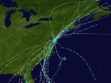
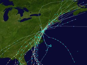
Since 1749, 108 tropical cyclones, including some that became extratropical, have affected the state. Most have occurred in September, which coincides with the peak of the Atlantic hurricane season.| Month | Number of recorded storms affecting Delaware |
|---|---|
| June | 6 |
| July | 9 |
| August | 30 |
| September | 45 |
| October | 18 |
| November | 2 |
Deadliest storms
Most tropical cyclones that impact Delaware only cause rainfall or strong waves, though a few have caused deaths in the state. Storms that caused deaths in Delaware include:| Name | Year | Number of deaths |
|---|---|---|
| Unnamed | 1785 | 181 |
| Unnamed | 1879 | "Probably exceed 40" |
| Gale of 1878 Gale of 1878 The Gale of 1878, was an intense Category 2 hurricane that caused extensive damage from Cuba to New England.-Meteorological history:A tropical storm formed off the coast of Jamaica on October 18, 1878, and moved nearly due north. On October 20, the storm reached hurricane status and on October 21,... |
1878 | 18 |
| Unnamed | 1904 | 8 |
| Vagabond Hurricane 1903 Vagabond hurricane The 1903 New Jersey hurricane, also known as the Vagabond Hurricane by The Press of Atlantic City, is the second most recent Atlantic hurricane to make first landfall in the state of New Jersey, preceding Hurricane Irene. The fourth hurricane of the season, the cyclone was first observed on... |
1903 | 5 |
| Unnamed | 1783 | "Several" |
| Floyd Hurricane Floyd Hurricane Floyd was the sixth named storm, fourth hurricane, and third major hurricane in the 1999 Atlantic hurricane season. Floyd triggered the third largest evacuation in US history when 2.6 million coastal residents of five states were ordered from their homes as it approached... |
1999 | 2 |
| Irene Hurricane Irene (2011) Hurricane Irene was a large and powerful Atlantic hurricane that left extensive flood and wind damage along its path through the Caribbean, the United States East Coast and as far north as Atlantic Canada in 2011... |
2011 | 2 |
| Hazel Hurricane Hazel Hurricane Hazel was the deadliest and costliest hurricane of the 1954 Atlantic hurricane season. The storm killed as many as 1,000 people in Haiti before striking the United States near the border between North and South Carolina, as a Category 4 hurricane... |
1954 | ≥1 |
| Agnes Hurricane Agnes Hurricane Agnes was the first tropical storm and first hurricane of the 1972 Atlantic hurricane season. A rare June hurricane, it made landfall on the Florida Panhandle before moving northeastward and ravaging the Mid-Atlantic region as a tropical storm... |
1972 | 1 |
Strongest storms
The following storms have caused hurricane-force winds in Delaware.| Name | Saffir-Simpson Saffir-Simpson Hurricane Scale The Saffir–Simpson Hurricane Scale , or the Saffir–Simpson Hurricane Wind Scale , classifies hurricanes — Western Hemisphere tropical cyclones that exceed the intensities of tropical depressions and tropical storms — into five categories distinguished by the intensities of their sustained winds... Category |
Date of closest approach | Year |
|---|---|---|---|
| Unnamed Gale of 1878 The Gale of 1878, was an intense Category 2 hurricane that caused extensive damage from Cuba to New England.-Meteorological history:A tropical storm formed off the coast of Jamaica on October 18, 1878, and moved nearly due north. On October 20, the storm reached hurricane status and on October 21,... |
1 | October 23 | 1878 |
| Unnamed 1903 Vagabond hurricane The 1903 New Jersey hurricane, also known as the Vagabond Hurricane by The Press of Atlantic City, is the second most recent Atlantic hurricane to make first landfall in the state of New Jersey, preceding Hurricane Irene. The fourth hurricane of the season, the cyclone was first observed on... |
1 | September 16 | 1903 |
| Hurricane Irene | 1 | August 28 | 2011 |
See also
- List of New Jersey hurricanes
- List of Atlantic hurricane seasons
- List of Atlantic hurricanes
- Tropical cycloneTropical cycloneA tropical cyclone is a storm system characterized by a large low-pressure center and numerous thunderstorms that produce strong winds and heavy rain. Tropical cyclones strengthen when water evaporated from the ocean is released as the saturated air rises, resulting in condensation of water vapor...
- Effects of Hurricane Isabel in DelawareEffects of Hurricane Isabel in DelawareThe effects of Hurricane Isabel in Delaware resulted in one of only twelve presidential disaster declarations for the state of Delaware. Hurricane Isabel formed from a tropical wave on September 6, 2003 in the tropical Atlantic Ocean...