
1981 Atlantic hurricane season
Encyclopedia
The 1981 Atlantic hurricane season officially began on June 1, 1981, and lasted until November 30, 1981. These dates conventionally delimit the period of each year when most tropical cyclone
s form in the Atlantic basin
. The 1981 season
was high in activity with 18 tropical depressions and twelve storms forming during the year. Nine of these systems made landfall. Cindy, Harvey, and Irene neither affected land directly nor indirectly.
Hurricane Dennis
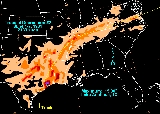
caused millions of dollars in damage in Dade County, Florida and produced the highest rainfall totals of any tropical cyclone this season. Tropical Depression Eight caused the most damage, due to flooding in Texas
at the end of August, and led to most fatalities of any tropical cyclone
this season (five). Tropical Depressions Two and Eight caused a majority of the damage and fatalities this season, with both affecting Louisiana
and Texas
. Katrina was the only named storm with associated fatalities.
 The 1981 season was high in activity with eighteen tropical depressions and twelve storms forming that year. The season began early, as Tropical Storm Arlene formed on May 6. Arlene made landfall in Cuba
, being absorbed by a low later. Tropical Depression Two moved out of the Gulf of Mexico into eastern Texas on June 5, producing localized rainfall amounts of 12 inches (304.8 mm) and numerous tornadoes over Louisiana before recurving across the Southeast United States. Tropical Storm Bret formed as a subtropical low in the open Atlantic Ocean, and made landfall in the Delmarva Peninsula.
Tropical Depression Four formed in the Gulf of Mexico on July 25, moving into Mexico the next day, and causing heavy rains in west Texas, Oklahoma, and Arkansas when its remnants moved into the United States. Tropical Storm Cindy formed on August 2 in the open Atlantic and became an extratropical cyclone
on August 5. Hurricane Dennis formed on August 7 near South America
. Dennis degenerated into a depression while making landfall in the Leeward Islands
, but regained storm strength while over Cuba
. Dennis moved near the southeast United States coastline from Florida to Virginia
, briefly becoming a hurricane. Dennis weakened into a tropical storm and was declared an extratropical cyclone
on August 22.
 Tropical Depression Seven formed in mid-August and tracked through the Windward Islands before dissipating in the eastern Caribbean Sea. Tropical Depression Eight led to a significant flooding event between San Antonio and Houston on August 30 and August 31 while recurving through Texas into Louisiana. Hurricane Emily formed on September 1 southeast of Bermuda
. Emily made a cyclonic loop as a tropical storm. Emily strengthened into a hurricane out in the North Atlantic Ocean and by September 12, was no longer identifiable. Hurricane Floyd was a Category 3 hurricane that grazed Bermuda, but no damage was reported. Hurricane Gert formed September 8, strengthened into a Category 2 hurricane, and followed the same track as Floyd, dissipating near the Azores. Hurricane Harvey became the strongest storm of the season, reaching Category 4 strength. Harvey never affected land, but ships reported tropical storm-force winds. Tropical Depression Thirteen brought gusts of tropical storm force to Bermuda in mid to late September. Hurricane Irene also stayed out at sea, reaching Category 3 strength and was extratropical in early October. The extratropical Irene made landfall in France
.
Tropical Depression Fifteen was small and well-organized as it crossed the tropical Atlantic before weakening as it moved through the northeast Caribbean and southwest North Atlantic during late September and early October. Tropical Storm Jose was a short-lived storm forming out in the open Atlantic in late October. Jose never affected land and dissipated on November 1 near the Azores. Hurricane Katrina formed in the Caribbean Sea, and made landfall in Cuba after reaching hurricane strength. Katrina was the only named storm with fatalities. The final storm of the season, Subtropical Storm Three, formed in the Atlantic Ocean on November 12 and moved north, making landfall in Nova Scotia and becoming extratropical soon after.
The season's activity was reflected with a cumulative accumulated cyclone energy
(ACE) rating of 100, which is classified as "near normal". ACE is, broadly speaking, a measure of the power of the hurricane multiplied by the length of time it existed, so storms that last a long time, as well as particularly strong hurricanes, have high ACEs. ACE is only calculated for full advisories on tropical systems at or exceeding 34 knots (39 mph, 63 km/h) or tropical storm strength. Subtropical cyclone
s are excluded from the total.
across Central America
into the Caribbean Sea
. As the disturbance tracked northeast across the western Caribbean, it became a tropical depression, then on May 7 reached tropical storm strength near the Cayman Islands
. Arlene struck eastern Cuba
on the night of May 7, and the passage over land weakened it to a depression. It restrengthened briefly over the southeastern Bahamas, but weakened again and was absorbed by another system. Reported damage was minimal.
Since Arlene, two subtropical cyclone
s have formed in May in 1997
and 2007
respectively. After Arlene, the next tropical cyclone
of tropical storm strength to form in May was Tropical Storm Arthur in 2008
, the second within a span of 27 years.
, Mexico
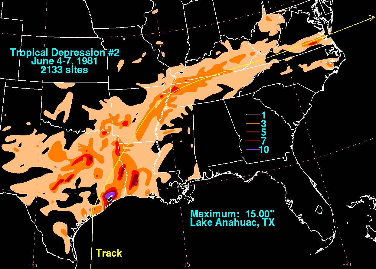
, on June 3. The system moved north-northwest, lured by a cyclone over the southern Plains. Tropical Depression Two made landfall along the upper Texas coast on June 5, spreading up to 15 inches (381 mm) of rainfall northeast of the point of landfall. A total of nine tornadoes stuck the western Gulf coast, with eight touching down in Louisiana
. Three people died; two due to flooding and one from an associated tornado. The depression quickly recurved through the Mississippi Valley, and deepened as it moved off the coast of the Mid-Atlantic states into the western subtropical Atlantic on June 7. At least US$4 million in damage was caused by this depression.
roughly 150 miles (241.4 km) off the coast of North Carolina
. The storm moved west-northwest, striking land in southern Maryland
on July 1. Bret weakened significantly just before landfall, and reported winds were below gale
force. Rainfall amounts were light, with a narrow area of over one inch of rain reported near its track and within the central Appalachians. The highest rainfall amount reported was 4.48 inches (113.8 mm) at Big Meadows, Virginia. No significant damage was reported, but one fatality was reported at Nags Head, North Carolina
due to riptides.
and Nova Scotia
. Cindy tracked east-northeast until it became extratropical on August 5 as it moved over colder water. The storm never affected land and caused no known damage.
s typically do. A tropical wave leaving the coast of Africa
on August 5 developed into Tropical Storm Dennis on the 7th near Cape Verde
. Unlike most such storms, Dennis degenerated to a tropical wave before reaching the Windward Islands
on August 12. This wave crossed the Caribbean, passing over Jamaica
before reaching the southwestern coast of Cuba
on August 15.
Once near Cuba, the wave began rapid organization, restrengthening into a tropical storm. It crossed Cuba, then moved into southern Florida
. Over Florida, steering currents weakened and the storm stalled. On August 19, Tropical Storm Dennis reemerged over water, skimming the coasts of the Carolinas before accelerating out to sea. Dennis reached hurricane strength before becoming extratropical on August 22.
Most damage associated with Dennis was from the heavy rainfall caused by its slow passage over Florida, although two tornadoes were also reported within Florida. The highest amount registered was near Homestead, Florida
, where 25.56 inches (649.2 mm) of rain was measured. Agriculture damage in Dade County, Florida was estimated at $15 million (1981 dollars). Coastal areas of the Carolinas were also affected by heavy rainfall, with spots seeing over 10 inches (254 mm), as well as minor beach erosion.
into the eastern Caribbean Sea before dissipating on August 21.
to north of Houston, Texas
. The highest rainfall amount reported was from Pine Springs in Fayette County, Texas
, where 21 inches (533.4 mm) fell in the 24 hour period ending on the morning of August 31. Five died in the town of Shiner, Texas
due to the flood. Downtown Halletsville flooded to a depth of 5 feet (1.5 m). Significant flooding occurred along the Lavaca, Guadalupe, and Colorado
rivers in Texas. The cyclone spawned 14 tornadoes as well, including one at Scholes Field in Galveston, Texas
which produced winds as high as 92 miles per hour (148.1 km/h) at 7:15 pm on August 31.
Its surface circulation remained ill-defined as it produced another round of heavy rainfall across northwest Louisiana on September 1. A large mesoscale convective system
moved in from Oklahoma and northeast Texas, dissipating what was left of this tropical depression by September 2. Paid losses by the Federal Emergency Management Agency
(FEMA) totaled nearly US$21 million (1981 dollars), with total damages exceeding US$26 million (1981 dollars).
, but no other damage was reported.
. As the depression moved northwest, it caused heavy rain. The highest rainfall reported was 5.7 inches (14.5 cm) at Antigua
. It strengthened into a tropical storm, then reached hurricane strength on the 7th.
Floyd turned to the northeast, and passed just southeast of Bermuda as a weakening hurricane. As a tropical storm, Floyd moved east across the Atlantic until losing its identity on September 12.
No damages are associated with Floyd. Although Bermuda was directly affected, the island experienced the weaker half of the storm.
. Gert passed through the eastern Leeward Islands
during the next few hours, but no significant winds were recorded. The next day, Gert's center moved across eastern Puerto Rico
where it caused moderate to heavy rainfall.
Much of the storm's circulation moved over the Dominican Republic
, causing weakening of the cyclone. Gert reached the southeastern Bahamas before turning northward. Gert continued turning, and simultaneously strengthened. On September 12, Gert passed just north of Bermuda, but only light winds were recorded on the island. The storm was weakening, and accelerated on an east-northeast path. Its circulation dissipated on September 15 in the vicinity of the Azores
.
, Harvey moved northwest. Its path began curving more to the north, and was considered a threat to Bermuda
until the continuing curve took Harvey away from the island. Harvey's track became more easterly, and the storm weakened and became extratropical as it approached the Azores. Harvey caused no reported damage, although several ships reported experiencing tropical storm force winds.
south of Nova Scotia on September 24.
became a named storm midway between the Windward Islands
and Cape Verde
on September 23, and its track mimicked that of Hurricane Harvey. The storm tracked northwest, becoming a hurricane on September 25. Its track then began curving to the east, eventually resulting in motion to the northeast.
The storm weakened and became extratropical in early October. The remaining extratropical storm moved over France
on October 3.
as the system passed by the island. The depression then recurved to the south and east of Bermuda late on October 3.
about 150 miles (241.4 km) south of the Cayman Islands
. The depression moved north, reaching tropical storm strength as it moved through the Caymans. Katrina continued to strengthen, reaching hurricane strength half a day before landfall in Cuba
. A weakening Katrina moved across eastern Cuba on November 6. After emerging over water, the storm accelerated northeast through the Bahamas. Katrina's circulation fell apart, and the storm merged with a front on November 8.
Hurricane Katrina is reported to have killed two and caused widespread flood damage in Cuba's Camagüey province
. Katrina was the only named storm responsible for fatalities in 1981.
organized into an subtropical storm on November 12 while 400 miles (643.7 km) east of Jacksonville, Florida
. After moving northeastward, it turned to the northwest, threatening the northeastern United States
as an intensifying subtropical storm that was gradually developing tropical characteristics. A high pressure system turned it to the northeast, and after peaking at 70 mi/h it became extratropical near Nova Scotia
on the 17th. The storm produced significant beach erosion and coastal flooding.
. It was the first use for all of these names since the post-1978 naming change, except for Arlene, Cindy and Irene which had been previously used in 1959, 1963, 1967, and 1971. Names that were not assigned are marked in .
.
Tropical cyclone
A tropical cyclone is a storm system characterized by a large low-pressure center and numerous thunderstorms that produce strong winds and heavy rain. Tropical cyclones strengthen when water evaporated from the ocean is released as the saturated air rises, resulting in condensation of water vapor...
s form in the Atlantic basin
Atlantic Basin
The Atlantic Basin is the Atlantic Ocean.Atlantic Basin may also refer to:* Atlantic Basin Iron Works, an ironworks that operated in Brooklyn, New York, in the early to mid-20th century...
. The 1981 season
Atlantic hurricane season
The Atlantic hurricane season is the period in a year when hurricanes usually form in the Atlantic Ocean. Tropical cyclones in the North Atlantic are called hurricanes, tropical storms, or tropical depressions. In addition, there have been several storms over the years that have not been fully...
was high in activity with 18 tropical depressions and twelve storms forming during the year. Nine of these systems made landfall. Cindy, Harvey, and Irene neither affected land directly nor indirectly.
Hurricane Dennis
Hurricane Dennis (1981)
Hurricane Dennis was the most damaging storm of the 1981 Atlantic hurricane season which took twelve and a half days to reach hurricane status. The tropical wave that later would become Dennis moved off the African coastline on August 5. By August 7 a tropical depression developed, which quickly...
caused millions of dollars in damage in Dade County, Florida and produced the highest rainfall totals of any tropical cyclone this season. Tropical Depression Eight caused the most damage, due to flooding in Texas
Texas
Texas is the second largest U.S. state by both area and population, and the largest state by area in the contiguous United States.The name, based on the Caddo word "Tejas" meaning "friends" or "allies", was applied by the Spanish to the Caddo themselves and to the region of their settlement in...
at the end of August, and led to most fatalities of any tropical cyclone
Tropical cyclone
A tropical cyclone is a storm system characterized by a large low-pressure center and numerous thunderstorms that produce strong winds and heavy rain. Tropical cyclones strengthen when water evaporated from the ocean is released as the saturated air rises, resulting in condensation of water vapor...
this season (five). Tropical Depressions Two and Eight caused a majority of the damage and fatalities this season, with both affecting Louisiana
Louisiana
Louisiana is a state located in the southern region of the United States of America. Its capital is Baton Rouge and largest city is New Orleans. Louisiana is the only state in the U.S. with political subdivisions termed parishes, which are local governments equivalent to counties...
and Texas
Texas
Texas is the second largest U.S. state by both area and population, and the largest state by area in the contiguous United States.The name, based on the Caddo word "Tejas" meaning "friends" or "allies", was applied by the Spanish to the Caddo themselves and to the region of their settlement in...
. Katrina was the only named storm with associated fatalities.
Seasonal activity
Cuba
The Republic of Cuba is an island nation in the Caribbean. The nation of Cuba consists of the main island of Cuba, the Isla de la Juventud, and several archipelagos. Havana is the largest city in Cuba and the country's capital. Santiago de Cuba is the second largest city...
, being absorbed by a low later. Tropical Depression Two moved out of the Gulf of Mexico into eastern Texas on June 5, producing localized rainfall amounts of 12 inches (304.8 mm) and numerous tornadoes over Louisiana before recurving across the Southeast United States. Tropical Storm Bret formed as a subtropical low in the open Atlantic Ocean, and made landfall in the Delmarva Peninsula.
Tropical Depression Four formed in the Gulf of Mexico on July 25, moving into Mexico the next day, and causing heavy rains in west Texas, Oklahoma, and Arkansas when its remnants moved into the United States. Tropical Storm Cindy formed on August 2 in the open Atlantic and became an extratropical cyclone
Extratropical cyclone
Extratropical cyclones, sometimes called mid-latitude cyclones or wave cyclones, are a group of cyclones defined as synoptic scale low pressure weather systems that occur in the middle latitudes of the Earth having neither tropical nor polar characteristics, and are connected with fronts and...
on August 5. Hurricane Dennis formed on August 7 near South America
South America
South America is a continent situated in the Western Hemisphere, mostly in the Southern Hemisphere, with a relatively small portion in the Northern Hemisphere. The continent is also considered a subcontinent of the Americas. It is bordered on the west by the Pacific Ocean and on the north and east...
. Dennis degenerated into a depression while making landfall in the Leeward Islands
Leeward Islands
The Leeward Islands are a group of islands in the West Indies. They are the northern islands of the Lesser Antilles chain. As a group they start east of Puerto Rico and reach southward to Dominica. They are situated where the northeastern Caribbean Sea meets the western Atlantic Ocean...
, but regained storm strength while over Cuba
Cuba
The Republic of Cuba is an island nation in the Caribbean. The nation of Cuba consists of the main island of Cuba, the Isla de la Juventud, and several archipelagos. Havana is the largest city in Cuba and the country's capital. Santiago de Cuba is the second largest city...
. Dennis moved near the southeast United States coastline from Florida to Virginia
Virginia
The Commonwealth of Virginia , is a U.S. state on the Atlantic Coast of the Southern United States. Virginia is nicknamed the "Old Dominion" and sometimes the "Mother of Presidents" after the eight U.S. presidents born there...
, briefly becoming a hurricane. Dennis weakened into a tropical storm and was declared an extratropical cyclone
Extratropical cyclone
Extratropical cyclones, sometimes called mid-latitude cyclones or wave cyclones, are a group of cyclones defined as synoptic scale low pressure weather systems that occur in the middle latitudes of the Earth having neither tropical nor polar characteristics, and are connected with fronts and...
on August 22.
Bermuda
Bermuda is a British overseas territory in the North Atlantic Ocean. Located off the east coast of the United States, its nearest landmass is Cape Hatteras, North Carolina, about to the west-northwest. It is about south of Halifax, Nova Scotia, Canada, and northeast of Miami, Florida...
. Emily made a cyclonic loop as a tropical storm. Emily strengthened into a hurricane out in the North Atlantic Ocean and by September 12, was no longer identifiable. Hurricane Floyd was a Category 3 hurricane that grazed Bermuda, but no damage was reported. Hurricane Gert formed September 8, strengthened into a Category 2 hurricane, and followed the same track as Floyd, dissipating near the Azores. Hurricane Harvey became the strongest storm of the season, reaching Category 4 strength. Harvey never affected land, but ships reported tropical storm-force winds. Tropical Depression Thirteen brought gusts of tropical storm force to Bermuda in mid to late September. Hurricane Irene also stayed out at sea, reaching Category 3 strength and was extratropical in early October. The extratropical Irene made landfall in France
France
The French Republic , The French Republic , The French Republic , (commonly known as France , is a unitary semi-presidential republic in Western Europe with several overseas territories and islands located on other continents and in the Indian, Pacific, and Atlantic oceans. Metropolitan France...
.
Tropical Depression Fifteen was small and well-organized as it crossed the tropical Atlantic before weakening as it moved through the northeast Caribbean and southwest North Atlantic during late September and early October. Tropical Storm Jose was a short-lived storm forming out in the open Atlantic in late October. Jose never affected land and dissipated on November 1 near the Azores. Hurricane Katrina formed in the Caribbean Sea, and made landfall in Cuba after reaching hurricane strength. Katrina was the only named storm with fatalities. The final storm of the season, Subtropical Storm Three, formed in the Atlantic Ocean on November 12 and moved north, making landfall in Nova Scotia and becoming extratropical soon after.
The season's activity was reflected with a cumulative accumulated cyclone energy
Accumulated cyclone energy
Accumulated cyclone energy is a measure used by the National Oceanic and Atmospheric Administration to express the activity of individual tropical cyclones and entire tropical cyclone seasons, particularly the North Atlantic hurricane season. It uses an approximation of the energy used by a...
(ACE) rating of 100, which is classified as "near normal". ACE is, broadly speaking, a measure of the power of the hurricane multiplied by the length of time it existed, so storms that last a long time, as well as particularly strong hurricanes, have high ACEs. ACE is only calculated for full advisories on tropical systems at or exceeding 34 knots (39 mph, 63 km/h) or tropical storm strength. Subtropical cyclone
Subtropical cyclone
A subtropical cyclone is a weather system that has some characteristics of a tropical and an extratropical cyclone. As early as the 1950s, meteorologists were unclear whether they should be characterized as tropical or extratropical cyclones. They were officially recognized by the National...
s are excluded from the total.
Tropical Storm Arlene
Arlene was a very unusual tropical storm in 1981. It formed on May 6, well before the beginning of the normal hurricane season. It developed out of a disturbance that moved from the Pacific OceanPacific Ocean
The Pacific Ocean is the largest of the Earth's oceanic divisions. It extends from the Arctic in the north to the Southern Ocean in the south, bounded by Asia and Australia in the west, and the Americas in the east.At 165.2 million square kilometres in area, this largest division of the World...
across Central America
Central America
Central America is the central geographic region of the Americas. It is the southernmost, isthmian portion of the North American continent, which connects with South America on the southeast. When considered part of the unified continental model, it is considered a subcontinent...
into the Caribbean Sea
Caribbean Sea
The Caribbean Sea is a sea of the Atlantic Ocean located in the tropics of the Western hemisphere. It is bounded by Mexico and Central America to the west and southwest, to the north by the Greater Antilles, and to the east by the Lesser Antilles....
. As the disturbance tracked northeast across the western Caribbean, it became a tropical depression, then on May 7 reached tropical storm strength near the Cayman Islands
Cayman Islands
The Cayman Islands is a British Overseas Territory and overseas territory of the European Union located in the western Caribbean Sea. The territory comprises the three islands of Grand Cayman, Cayman Brac, and Little Cayman, located south of Cuba and northwest of Jamaica...
. Arlene struck eastern Cuba
Cuba
The Republic of Cuba is an island nation in the Caribbean. The nation of Cuba consists of the main island of Cuba, the Isla de la Juventud, and several archipelagos. Havana is the largest city in Cuba and the country's capital. Santiago de Cuba is the second largest city...
on the night of May 7, and the passage over land weakened it to a depression. It restrengthened briefly over the southeastern Bahamas, but weakened again and was absorbed by another system. Reported damage was minimal.
Since Arlene, two subtropical cyclone
Subtropical cyclone
A subtropical cyclone is a weather system that has some characteristics of a tropical and an extratropical cyclone. As early as the 1950s, meteorologists were unclear whether they should be characterized as tropical or extratropical cyclones. They were officially recognized by the National...
s have formed in May in 1997
1997 Atlantic hurricane season
The 1997 Atlantic hurricane season is the most recent Atlantic hurricane season to feature no tropical cyclones in August. The season officially began on June 1, 1997, and lasted until November 30, 1997...
and 2007
2007 Atlantic hurricane season
The 2007 Atlantic hurricane season was an active Atlantic hurricane season that produced 17 tropical cyclones, 15 tropical storms, six hurricanes, and two major hurricanes. It officially started on June 1 and ended on November 30, dates which conventionally delimit the...
respectively. After Arlene, the next tropical cyclone
Tropical cyclone
A tropical cyclone is a storm system characterized by a large low-pressure center and numerous thunderstorms that produce strong winds and heavy rain. Tropical cyclones strengthen when water evaporated from the ocean is released as the saturated air rises, resulting in condensation of water vapor...
of tropical storm strength to form in May was Tropical Storm Arthur in 2008
Tropical Storm Arthur (2008)
Tropical Storm Arthur was the first Atlantic tropical storm that formed during the month of May since 1981. The first tropical cyclone of the 2008 Atlantic hurricane season, the storm formed on May 30 from the interaction of two tropical waves and the remnants of the eastern Pacific Tropical...
, the second within a span of 27 years.
Tropical Depression Two
A tropical depression formed in the Bay of Campeche near VeracruzVeracruz, Veracruz
Veracruz, officially known as Heroica Veracruz, is a major port city and municipality on the Gulf of Mexico in the Mexican state of Veracruz. The city is located in the central part of the state. It is located along Federal Highway 140 from the state capital Xalapa, and is the state's most...
, Mexico
Mexico
The United Mexican States , commonly known as Mexico , is a federal constitutional republic in North America. It is bordered on the north by the United States; on the south and west by the Pacific Ocean; on the southeast by Guatemala, Belize, and the Caribbean Sea; and on the east by the Gulf of...
, on June 3. The system moved north-northwest, lured by a cyclone over the southern Plains. Tropical Depression Two made landfall along the upper Texas coast on June 5, spreading up to 15 inches (381 mm) of rainfall northeast of the point of landfall. A total of nine tornadoes stuck the western Gulf coast, with eight touching down in Louisiana
Louisiana
Louisiana is a state located in the southern region of the United States of America. Its capital is Baton Rouge and largest city is New Orleans. Louisiana is the only state in the U.S. with political subdivisions termed parishes, which are local governments equivalent to counties...
. Three people died; two due to flooding and one from an associated tornado. The depression quickly recurved through the Mississippi Valley, and deepened as it moved off the coast of the Mid-Atlantic states into the western subtropical Atlantic on June 7. At least US$4 million in damage was caused by this depression.
Tropical Storm Bret
Bret formed out of a subtropical lowSubtropical cyclone
A subtropical cyclone is a weather system that has some characteristics of a tropical and an extratropical cyclone. As early as the 1950s, meteorologists were unclear whether they should be characterized as tropical or extratropical cyclones. They were officially recognized by the National...
roughly 150 miles (241.4 km) off the coast of North Carolina
North Carolina
North Carolina is a state located in the southeastern United States. The state borders South Carolina and Georgia to the south, Tennessee to the west and Virginia to the north. North Carolina contains 100 counties. Its capital is Raleigh, and its largest city is Charlotte...
. The storm moved west-northwest, striking land in southern Maryland
Maryland
Maryland is a U.S. state located in the Mid Atlantic region of the United States, bordering Virginia, West Virginia, and the District of Columbia to its south and west; Pennsylvania to its north; and Delaware to its east...
on July 1. Bret weakened significantly just before landfall, and reported winds were below gale
Gale
A gale is a very strong wind. There are conflicting definitions of how strong a wind must be to be considered a gale. The U.S. government's National Weather Service defines a gale as 34–47 knots of sustained surface winds. Forecasters typically issue gale warnings when winds of this strength are...
force. Rainfall amounts were light, with a narrow area of over one inch of rain reported near its track and within the central Appalachians. The highest rainfall amount reported was 4.48 inches (113.8 mm) at Big Meadows, Virginia. No significant damage was reported, but one fatality was reported at Nags Head, North Carolina
Nags Head, North Carolina
Nags Head is a town in Dare County, North Carolina, United States. The population was 2,700 at the 2000 census.-History:Early maps of the area show Nags Head as a promontory of land characterized by high sand dunes visible from miles at sea...
due to riptides.
Tropical Depression Four
A tropical disturbance moved across the Caribbean sea between July 20 and July 24 before moving across the Yucatán peninsula. After emerging into the south-central Gulf of Mexico, the disturbance organized into a tropical depression early on July 25. The depression moved west-northwest into northeast Mexico on July 26 before its surface circulation dissipated. Heavy rains fell across western Texas, Oklahoma, and Arkansas when the remains of this system interacted with a stationary front across the southern Plains between July 28 and July 30.Tropical Storm Cindy
A subtropical depression that developed along a cold front organized into Tropical Storm Cindy on August 2, in the open Atlantic midway between BermudaBermuda
Bermuda is a British overseas territory in the North Atlantic Ocean. Located off the east coast of the United States, its nearest landmass is Cape Hatteras, North Carolina, about to the west-northwest. It is about south of Halifax, Nova Scotia, Canada, and northeast of Miami, Florida...
and Nova Scotia
Nova Scotia
Nova Scotia is one of Canada's three Maritime provinces and is the most populous province in Atlantic Canada. The name of the province is Latin for "New Scotland," but "Nova Scotia" is the recognized, English-language name of the province. The provincial capital is Halifax. Nova Scotia is the...
. Cindy tracked east-northeast until it became extratropical on August 5 as it moved over colder water. The storm never affected land and caused no known damage.
Hurricane Dennis
Dennis began as Cape Verde-type hurricaneCape Verde-type hurricane
A Cape Verde-type hurricane is an Atlantic hurricane that develops near the Cape Verde islands, off the west coast of Africa. The average hurricane season has about two Cape Verde-type hurricanes, which are usually the largest and most intense storms of the season because they often have plenty of...
s typically do. A tropical wave leaving the coast of Africa
Africa
Africa is the world's second largest and second most populous continent, after Asia. At about 30.2 million km² including adjacent islands, it covers 6% of the Earth's total surface area and 20.4% of the total land area...
on August 5 developed into Tropical Storm Dennis on the 7th near Cape Verde
Cape Verde
The Republic of Cape Verde is an island country, spanning an archipelago of 10 islands located in the central Atlantic Ocean, 570 kilometres off the coast of Western Africa...
. Unlike most such storms, Dennis degenerated to a tropical wave before reaching the Windward Islands
Windward Islands
The Windward Islands are the southern islands of the Lesser Antilles, within the West Indies.-Name and geography:The Windward Islands are called such because they were more windward to sailing ships arriving in the New World than the Leeward Islands, given that the prevailing trade winds in the...
on August 12. This wave crossed the Caribbean, passing over Jamaica
Jamaica
Jamaica is an island nation of the Greater Antilles, in length, up to in width and 10,990 square kilometres in area. It is situated in the Caribbean Sea, about south of Cuba, and west of Hispaniola, the island harbouring the nation-states Haiti and the Dominican Republic...
before reaching the southwestern coast of Cuba
Cuba
The Republic of Cuba is an island nation in the Caribbean. The nation of Cuba consists of the main island of Cuba, the Isla de la Juventud, and several archipelagos. Havana is the largest city in Cuba and the country's capital. Santiago de Cuba is the second largest city...
on August 15.
Once near Cuba, the wave began rapid organization, restrengthening into a tropical storm. It crossed Cuba, then moved into southern Florida
Florida
Florida is a state in the southeastern United States, located on the nation's Atlantic and Gulf coasts. It is bordered to the west by the Gulf of Mexico, to the north by Alabama and Georgia and to the east by the Atlantic Ocean. With a population of 18,801,310 as measured by the 2010 census, it...
. Over Florida, steering currents weakened and the storm stalled. On August 19, Tropical Storm Dennis reemerged over water, skimming the coasts of the Carolinas before accelerating out to sea. Dennis reached hurricane strength before becoming extratropical on August 22.
Most damage associated with Dennis was from the heavy rainfall caused by its slow passage over Florida, although two tornadoes were also reported within Florida. The highest amount registered was near Homestead, Florida
Homestead, Florida
Homestead is a city in Miami-Dade County, Florida, United States nestled between Biscayne National Park to the east and Everglades National Park to the west. Homestead is primarily a Miami suburb and a major agricultural area....
, where 25.56 inches (649.2 mm) of rain was measured. Agriculture damage in Dade County, Florida was estimated at $15 million (1981 dollars). Coastal areas of the Carolinas were also affected by heavy rainfall, with spots seeing over 10 inches (254 mm), as well as minor beach erosion.
Tropical Depression Seven
This system developed across the tropical Atlantic ocean on August 18, moving westward through the Windward islandsWindward Islands
The Windward Islands are the southern islands of the Lesser Antilles, within the West Indies.-Name and geography:The Windward Islands are called such because they were more windward to sailing ships arriving in the New World than the Leeward Islands, given that the prevailing trade winds in the...
into the eastern Caribbean Sea before dissipating on August 21.
Tropical Depression Eight
This tropical depression formed in the Bay of Campeche on August 26 and moved slowly northwest, moving ashore northeast Mexico on August 29 and into the United States on August 30. As an ill-defined surface low, a large thunderstorm complex formed near its center that day, unleashing heavy rainfall in a band 50 miles (80.5 km) wide which stretched along a path 200 miles (321.9 km) long from Seguin, TexasSeguin, Texas
Seguin is a city in Guadalupe County, Texas, in the United States. It is part of the San Antonio-New Braunfels Metropolitan Statistical Area. As of the 2000 census, the city population was 22,011; the July 1, 2009 Census estimate, however, showed the population had increased to 26,842...
to north of Houston, Texas
Houston, Texas
Houston is the fourth-largest city in the United States, and the largest city in the state of Texas. According to the 2010 U.S. Census, the city had a population of 2.1 million people within an area of . Houston is the seat of Harris County and the economic center of , which is the ...
. The highest rainfall amount reported was from Pine Springs in Fayette County, Texas
Fayette County, Texas
Fayette County is a county located in the U.S. state of Texas. As of 2000, the population was 21,804. Its county seat is La Grange. Fayette is named for the Marquis de la Fayette, a French nobleman who became an American Revolutionary War hero...
, where 21 inches (533.4 mm) fell in the 24 hour period ending on the morning of August 31. Five died in the town of Shiner, Texas
Shiner, Texas
Shiner is a city in Lavaca County, Texas, United States. The town was named after Henry B. Shiner who donated for railroad right of way. As of the 2000 census, the city had a population of 2,070....
due to the flood. Downtown Halletsville flooded to a depth of 5 feet (1.5 m). Significant flooding occurred along the Lavaca, Guadalupe, and Colorado
Colorado River
The Colorado River , is a river in the Southwestern United States and northwestern Mexico, approximately long, draining a part of the arid regions on the western slope of the Rocky Mountains. The watershed of the Colorado River covers in parts of seven U.S. states and two Mexican states...
rivers in Texas. The cyclone spawned 14 tornadoes as well, including one at Scholes Field in Galveston, Texas
Galveston, Texas
Galveston is a coastal city located on Galveston Island in the U.S. state of Texas. , the city had a total population of 47,743 within an area of...
which produced winds as high as 92 miles per hour (148.1 km/h) at 7:15 pm on August 31.
Its surface circulation remained ill-defined as it produced another round of heavy rainfall across northwest Louisiana on September 1. A large mesoscale convective system
Mesoscale Convective System
A mesoscale convective system is a complex of thunderstorms that becomes organized on a scale larger than the individual thunderstorms but smaller than extratropical cyclones, and normally persists for several hours or more...
moved in from Oklahoma and northeast Texas, dissipating what was left of this tropical depression by September 2. Paid losses by the Federal Emergency Management Agency
Federal Emergency Management Agency
The Federal Emergency Management Agency is an agency of the United States Department of Homeland Security, initially created by Presidential Reorganization Plan No. 1 of 1978 and implemented by two Executive Orders...
(FEMA) totaled nearly US$21 million (1981 dollars), with total damages exceeding US$26 million (1981 dollars).
Hurricane Emily
On September 1, a subtropical storm became Tropical Storm Emily southwest of Bermuda. Emily moved northeast, crossing the island the next day, but measured winds were below tropical storm force. The storm continued generally northeast and strengthened into a hurricane. Hurricane Emily weakened over the north Atlantic and was no longer identifiable as a weather system by September 12. Hurricane Emily caused beach erosion across the East Coast of the United StatesEast Coast of the United States
The East Coast of the United States, also known as the Eastern Seaboard, refers to the easternmost coastal states in the United States, which touch the Atlantic Ocean and stretch up to Canada. The term includes the U.S...
, but no other damage was reported.
Hurricane Floyd
Floyd was first tracked as a tropical depression on September 3 when it organized east of the Leeward IslandsLeeward Islands
The Leeward Islands are a group of islands in the West Indies. They are the northern islands of the Lesser Antilles chain. As a group they start east of Puerto Rico and reach southward to Dominica. They are situated where the northeastern Caribbean Sea meets the western Atlantic Ocean...
. As the depression moved northwest, it caused heavy rain. The highest rainfall reported was 5.7 inches (14.5 cm) at Antigua
Antigua
Antigua , also known as Waladli, is an island in the West Indies, in the Leeward Islands in the Caribbean region, the main island of the country of Antigua and Barbuda. Antigua means "ancient" in Spanish and was named by Christopher Columbus after an icon in Seville Cathedral, Santa Maria de la...
. It strengthened into a tropical storm, then reached hurricane strength on the 7th.
Floyd turned to the northeast, and passed just southeast of Bermuda as a weakening hurricane. As a tropical storm, Floyd moved east across the Atlantic until losing its identity on September 12.
No damages are associated with Floyd. Although Bermuda was directly affected, the island experienced the weaker half of the storm.
Hurricane Gert
A tropical depression became Tropical Storm Gert on September 8, roughly 115 miles (185.1 km) east of GuadeloupeGuadeloupe
Guadeloupe is an archipelago located in the Leeward Islands, in the Lesser Antilles, with a land area of 1,628 square kilometres and a population of 400,000. It is the first overseas region of France, consisting of a single overseas department. As with the other overseas departments, Guadeloupe...
. Gert passed through the eastern Leeward Islands
Leeward Islands
The Leeward Islands are a group of islands in the West Indies. They are the northern islands of the Lesser Antilles chain. As a group they start east of Puerto Rico and reach southward to Dominica. They are situated where the northeastern Caribbean Sea meets the western Atlantic Ocean...
during the next few hours, but no significant winds were recorded. The next day, Gert's center moved across eastern Puerto Rico
Puerto Rico
Puerto Rico , officially the Commonwealth of Puerto Rico , is an unincorporated territory of the United States, located in the northeastern Caribbean, east of the Dominican Republic and west of both the United States Virgin Islands and the British Virgin Islands.Puerto Rico comprises an...
where it caused moderate to heavy rainfall.
Much of the storm's circulation moved over the Dominican Republic
Dominican Republic
The Dominican Republic is a nation on the island of La Hispaniola, part of the Greater Antilles archipelago in the Caribbean region. The western third of the island is occupied by the nation of Haiti, making Hispaniola one of two Caribbean islands that are shared by two countries...
, causing weakening of the cyclone. Gert reached the southeastern Bahamas before turning northward. Gert continued turning, and simultaneously strengthened. On September 12, Gert passed just north of Bermuda, but only light winds were recorded on the island. The storm was weakening, and accelerated on an east-northeast path. Its circulation dissipated on September 15 in the vicinity of the Azores
Azores
The Archipelago of the Azores is composed of nine volcanic islands situated in the middle of the North Atlantic Ocean, and is located about west from Lisbon and about east from the east coast of North America. The islands, and their economic exclusion zone, form the Autonomous Region of the...
.
Hurricane Harvey
Harvey formed in the central Atlantic, reaching hurricane strength only a few hours after first becoming a named system on September 12. From its initial position several hundred miles east of the Leeward IslandsLeeward Islands
The Leeward Islands are a group of islands in the West Indies. They are the northern islands of the Lesser Antilles chain. As a group they start east of Puerto Rico and reach southward to Dominica. They are situated where the northeastern Caribbean Sea meets the western Atlantic Ocean...
, Harvey moved northwest. Its path began curving more to the north, and was considered a threat to Bermuda
Bermuda
Bermuda is a British overseas territory in the North Atlantic Ocean. Located off the east coast of the United States, its nearest landmass is Cape Hatteras, North Carolina, about to the west-northwest. It is about south of Halifax, Nova Scotia, Canada, and northeast of Miami, Florida...
until the continuing curve took Harvey away from the island. Harvey's track became more easterly, and the storm weakened and became extratropical as it approached the Azores. Harvey caused no reported damage, although several ships reported experiencing tropical storm force winds.
Tropical Depression Thirteen
The thirteenth tropical depression developed 275 mi (442.6 km) southwest of Bermuda on September 22, and was initially expected to intensify into a tropical storm. Although it failed to further intensify, Tropical Depression Thirteen brought squalls to Bermuda with winds gusts of tropical storm force as it passed west of the island on September 23. Moving northward, the system merged with a developing extratropical cycloneExtratropical cyclone
Extratropical cyclones, sometimes called mid-latitude cyclones or wave cyclones, are a group of cyclones defined as synoptic scale low pressure weather systems that occur in the middle latitudes of the Earth having neither tropical nor polar characteristics, and are connected with fronts and...
south of Nova Scotia on September 24.
Hurricane Irene
IreneIrene
Irene is a name derived from the Greek word εἰρήνη meaning "peace". It may also be spelled or transliterated as "Irini", "Eirene", or "Eirini".It may refer to:-Mythical figures:* Eirene , one of the Horae...
became a named storm midway between the Windward Islands
Windward Islands
The Windward Islands are the southern islands of the Lesser Antilles, within the West Indies.-Name and geography:The Windward Islands are called such because they were more windward to sailing ships arriving in the New World than the Leeward Islands, given that the prevailing trade winds in the...
and Cape Verde
Cape Verde
The Republic of Cape Verde is an island country, spanning an archipelago of 10 islands located in the central Atlantic Ocean, 570 kilometres off the coast of Western Africa...
on September 23, and its track mimicked that of Hurricane Harvey. The storm tracked northwest, becoming a hurricane on September 25. Its track then began curving to the east, eventually resulting in motion to the northeast.
The storm weakened and became extratropical in early October. The remaining extratropical storm moved over France
France
The French Republic , The French Republic , The French Republic , (commonly known as France , is a unitary semi-presidential republic in Western Europe with several overseas territories and islands located on other continents and in the Indian, Pacific, and Atlantic oceans. Metropolitan France...
on October 3.
Tropical Depression Fifteen
This tropical depression formed southwest of the Cape Verde Islands on September 27, and tracked through the deep tropics before weakening as it moved over the Leeward Islands late on September 30. Heavy rains occurred at GuadeloupeGuadeloupe
Guadeloupe is an archipelago located in the Leeward Islands, in the Lesser Antilles, with a land area of 1,628 square kilometres and a population of 400,000. It is the first overseas region of France, consisting of a single overseas department. As with the other overseas departments, Guadeloupe...
as the system passed by the island. The depression then recurved to the south and east of Bermuda late on October 3.
Tropical Storm Jose
Jose was a weak and short-lived tropical storm that formed far from land on October 29. It moved generally northeast before becoming subtropical and then dissipating on November 1 near the Azores.Hurricane Katrina
A tropical depression formed on November 3 in the western Caribbean SeaCaribbean Sea
The Caribbean Sea is a sea of the Atlantic Ocean located in the tropics of the Western hemisphere. It is bounded by Mexico and Central America to the west and southwest, to the north by the Greater Antilles, and to the east by the Lesser Antilles....
about 150 miles (241.4 km) south of the Cayman Islands
Cayman Islands
The Cayman Islands is a British Overseas Territory and overseas territory of the European Union located in the western Caribbean Sea. The territory comprises the three islands of Grand Cayman, Cayman Brac, and Little Cayman, located south of Cuba and northwest of Jamaica...
. The depression moved north, reaching tropical storm strength as it moved through the Caymans. Katrina continued to strengthen, reaching hurricane strength half a day before landfall in Cuba
Cuba
The Republic of Cuba is an island nation in the Caribbean. The nation of Cuba consists of the main island of Cuba, the Isla de la Juventud, and several archipelagos. Havana is the largest city in Cuba and the country's capital. Santiago de Cuba is the second largest city...
. A weakening Katrina moved across eastern Cuba on November 6. After emerging over water, the storm accelerated northeast through the Bahamas. Katrina's circulation fell apart, and the storm merged with a front on November 8.
Hurricane Katrina is reported to have killed two and caused widespread flood damage in Cuba's Camagüey province
Camagüey Province
Camagüey is the largest of the provinces of Cuba. Its capital is Camagüey. Other towns include Florida and Nuevitas.-Geography:Camagüey is mostly low lying, with no major hills or mountain ranges passing through the province...
. Katrina was the only named storm responsible for fatalities in 1981.
Subtropical Storm Three
A frontal low over the warm waters of the Gulf StreamGulf Stream
The Gulf Stream, together with its northern extension towards Europe, the North Atlantic Drift, is a powerful, warm, and swift Atlantic ocean current that originates at the tip of Florida, and follows the eastern coastlines of the United States and Newfoundland before crossing the Atlantic Ocean...
organized into an subtropical storm on November 12 while 400 miles (643.7 km) east of Jacksonville, Florida
Jacksonville, Florida
Jacksonville is the largest city in the U.S. state of Florida in terms of both population and land area, and the largest city by area in the contiguous United States. It is the county seat of Duval County, with which the city government consolidated in 1968...
. After moving northeastward, it turned to the northwest, threatening the northeastern United States
United States
The United States of America is a federal constitutional republic comprising fifty states and a federal district...
as an intensifying subtropical storm that was gradually developing tropical characteristics. A high pressure system turned it to the northeast, and after peaking at 70 mi/h it became extratropical near Nova Scotia
Nova Scotia
Nova Scotia is one of Canada's three Maritime provinces and is the most populous province in Atlantic Canada. The name of the province is Latin for "New Scotland," but "Nova Scotia" is the recognized, English-language name of the province. The provincial capital is Halifax. Nova Scotia is the...
on the 17th. The storm produced significant beach erosion and coastal flooding.
Season summary
Storm names
The following names were used for named storms that formed in the north Atlantic in 1981. No names were retired, so it was used again in the 1987 season1987 Atlantic hurricane season
The 1987 Atlantic hurricane season was a below-average hurricane season that was limited by an ongoing El Niño. The season officially began on June 1, 1987, and lasted until November 30, 1987, although activity began on May 25 when a tropical depression developed in the east central...
. It was the first use for all of these names since the post-1978 naming change, except for Arlene, Cindy and Irene which had been previously used in 1959, 1963, 1967, and 1971. Names that were not assigned are marked in .
|
Hurricane Katrina (1981) Hurricane Katrina was the twenty-first tropical depression, eleventh named storm and seventh hurricane of the 1981 Atlantic hurricane season. During its lifetime, Katrina affected the Cayman Islands, Cuba and the Bahamas, causing the death of two people in Cuba as it passed over the island... |
Retirement
Due to lack of major damage from the storms, the WMO did not retire any names in 1981. They were used again in 19871987 Atlantic hurricane season
The 1987 Atlantic hurricane season was a below-average hurricane season that was limited by an ongoing El Niño. The season officially began on June 1, 1987, and lasted until November 30, 1987, although activity began on May 25 when a tropical depression developed in the east central...
.
See also
- List of Atlantic hurricanes
- List of Atlantic hurricane seasons
- 1981 Pacific hurricane season1981 Pacific hurricane seasonThe 1981 Pacific hurricane season was a moderately active Pacific hurricane season with six tropical cyclones directly affecting land. The season officially started on May 15 in the eastern Pacific, and on June 1 in the central Pacific, and ended on November 30; these dates conventionally delimit...
- 1981 Pacific typhoon season1981 Pacific typhoon seasonThe 1981 Pacific typhoon season has no official bounds; it ran year-round in 1981, but most tropical cyclones tend to form in the northwestern Pacific Ocean between May and November. These dates conventionally delimit the period of each year when most tropical cyclones form in the northwestern...
- 1981 North Indian Ocean cyclone season
- Southern Hemisphere tropical cyclone seasons: 1980–81, 1981–82