

Cape Henlopen
Encyclopedia
Headlands and bays
Headlands and bays are two related features of the coastal environment.- Geology and geography :Headlands and bays are often found on the same coastline. A bay is surrounded by land on three sides, whereas a headland is surrounded by water on three sides. Headlands are characterized by high,...
of the Delaware Bay
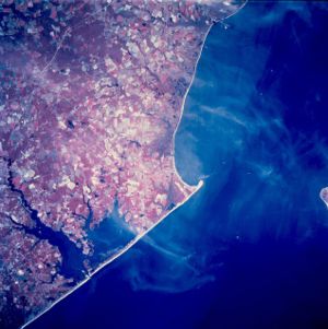
Delaware Bay
Delaware Bay is a major estuary outlet of the Delaware River on the Northeast seaboard of the United States whose fresh water mixes for many miles with the waters of the Atlantic Ocean. It is in area. The bay is bordered by the State of New Jersey and the State of Delaware...
along the Atlantic coast of the United States
United States
The United States of America is a federal constitutional republic comprising fifty states and a federal district...
. It lies in the state of Delaware
Delaware
Delaware is a U.S. state located on the Atlantic Coast in the Mid-Atlantic region of the United States. It is bordered to the south and west by Maryland, and to the north by Pennsylvania...
, near the town of Lewes, Delaware
Lewes, Delaware
Lewes is an incorporated city in Sussex County, Delaware, USA, on the Delmarva Peninsula. According to the 2010 census, the population is 2,747, a decrease of 6.3% from 2000....
. Off the coast on the bay side are two lighthouse
Lighthouse
A lighthouse is a tower, building, or other type of structure designed to emit light from a system of lamps and lenses or, in older times, from a fire, and used as an aid to navigation for maritime pilots at sea or on inland waterways....
s, called the Harbor of Refuge Light
Harbor of Refuge Light
The Harbor of Refuge Light is a lighthouse built on the ocean end of the outer Delaware Breakwater at the mouth of the Delaware Bay, just off Cape Henlopen...
and the Delaware Breakwater East End Light
Delaware Breakwater East End Light
The Delaware Breakwater East End Light is a lighthouse located on the inner Delaware Breakwater in the Delaware Bay, just off the coast of Cape Henlopen and the town of Lewes, Delaware.-Construction and Early Use :...
.
Early history
Originally spelled Cape Hinlopen, Cape Henlopen is named after Thijmen Jacobsz HinlopenThijmen Jacobsz Hinlopen
Thijmen Jacobsz Hinlopen , was one of the leaders of the Dutch merchant and whaling company of Noordsche Compagnie since 1617 and participant in the New Netherland Company, interested in furs...
who was a prominent Dutch
Netherlands
The Netherlands is a constituent country of the Kingdom of the Netherlands, located mainly in North-West Europe and with several islands in the Caribbean. Mainland Netherlands borders the North Sea to the north and west, Belgium to the south, and Germany to the east, and shares maritime borders...
trader. Cape Hinlopen was New Netherland's most southern border on the 37th parallel north
37th parallel north
The 37th parallel north is a circle of latitude that is 37 degrees north of the Earth's equatorial plane. It crosses Europe, the Mediterranean Sea, Africa, Asia, the Pacific Ocean, North America, and the Atlantic Ocean....
.
In 1620, Thijmen Jacobsz Hinlopen became Cornelis Jacobsen Mey's (the now washed out Cape Cornelius and the incorrectly spelled Cape May) business partner in the ships Blijde Boodschap (en. "Joyful Message") and Bever which focused on exploration and trade with the Indians in the Zuidt Rivier (Delaware River
Delaware River
The Delaware River is a major river on the Atlantic coast of the United States.A Dutch expedition led by Henry Hudson in 1609 first mapped the river. The river was christened the South River in the New Netherland colony that followed, in contrast to the North River, as the Hudson River was then...
) in 1620.
The area between the 38th
38th parallel north
The 38th parallel north is a circle of latitude that is 38 degrees north of the Earth's equatorial plane. It crosses Europe, the Mediterranean Sea, Asia, the Pacific Ocean, North America, and the Atlantic Ocean...
and 40th parallels
40th parallel north
The 40th parallel north is a circle of latitude that is 40 degrees north of the Earth's equatorial plane. It crosses Europe, the Mediterranean Sea, Asia, the Pacific Ocean, North America, and the Atlantic Ocean....
(i.e., the Delaware Bay area) as well as the Delaware River from north to south had previously been surveyed and charted by Cornelis Hendricksz from Monnikendam on the ship "Onrust" in 1614, 1615 and 1616. From August until November 1616, the New Netherland Company, which had an exclusive trading patent for the New Netherland
New Netherland
New Netherland, or Nieuw-Nederland in Dutch, was the 17th-century colonial province of the Republic of the Seven United Netherlands on the East Coast of North America. The claimed territories were the lands from the Delmarva Peninsula to extreme southwestern Cape Cod...
territory between 40° and 45° latitude, had tried unsuccessfully to obtain an exclusive patent from the States General of the Dutch Republic for the territory between 38° and 40° latitude.
Cornelis Jacobsz May was also unable to trade in the South River (Delaware River) at the exclusion of competing Dutch companies. Those Dutch companies came in conflict with one another but were eventually able to reach agreement in New Netherland. Discord arose again which was settled, finally, by a judgment of arbitrators at Amsterdam on December 23, 1623. The 38th and 39th parallels
39th parallel north
The 39th parallel north is a circle of latitude that is 39 degrees north of the Earth's equatorial plane. It crosses Europe, the Mediterranean Sea, Asia, the Pacific Ocean, North America, and the Atlantic Ocean....
region came under the final jurisdiction of the Dutch West India Company on behalf of the States General with the delivery of the first settlers to Governors Island
Governors Island
Governors Island is a island in Upper New York Bay, approximately one-half mile from the southern tip of Manhattan Island and separated from Brooklyn by Buttermilk Channel. It is legally part of the borough of Manhattan in New York City...
in New Netherland
New Netherland
New Netherland, or Nieuw-Nederland in Dutch, was the 17th-century colonial province of the Republic of the Seven United Netherlands on the East Coast of North America. The claimed territories were the lands from the Delmarva Peninsula to extreme southwestern Cape Cod...
in 1624. Those settlers were subsequently spread out onto Verhulsten Island (Burlington Island) in the Delaware, at Fort Orange
Fort Orange
Fort Orange was the first permanent Dutch settlement in New Netherland and was on the site of the present-day city of Albany, New York. It was a replacement for Fort Nassau, which had been built on nearby Castle Island in the Hudson River, and which served as a trading post until 1617 or 1618,...
(now Albany
Albany, New York
Albany is the capital city of the U.S. state of New York, the seat of Albany County, and the central city of New York's Capital District. Roughly north of New York City, Albany sits on the west bank of the Hudson River, about south of its confluence with the Mohawk River...
) in the Hudson River
Hudson River
The Hudson is a river that flows from north to south through eastern New York. The highest official source is at Lake Tear of the Clouds, on the slopes of Mount Marcy in the Adirondack Mountains. The river itself officially begins in Henderson Lake in Newcomb, New York...
and at the mouth of the Connecticut River
Connecticut River
The Connecticut River is the largest and longest river in New England, and also an American Heritage River. It flows roughly south, starting from the Fourth Connecticut Lake in New Hampshire. After flowing through the remaining Connecticut Lakes and Lake Francis, it defines the border between the...
in order to finalize the claim to New Netherland as a North American province according to the Law of Nations (Hugo Grotius
Hugo Grotius
Hugo Grotius , also known as Huig de Groot, Hugo Grocio or Hugo de Groot, was a jurist in the Dutch Republic. With Francisco de Vitoria and Alberico Gentili he laid the foundations for international law, based on natural law...
).
In 1782 during the American Revolutionary War
American Revolutionary War
The American Revolutionary War , the American War of Independence, or simply the Revolutionary War, began as a war between the Kingdom of Great Britain and thirteen British colonies in North America, and ended in a global war between several European great powers.The war was the result of the...
, the young Continental Navy
Continental Navy
The Continental Navy was the navy of the United States during the American Revolutionary War, and was formed in 1775. Through the efforts of the Continental Navy's patron, John Adams and vigorous Congressional support in the face of stiff opposition, the fleet cumulatively became relatively...
Lieutenant
Lieutenant
A lieutenant is a junior commissioned officer in many nations' armed forces. Typically, the rank of lieutenant in naval usage, while still a junior officer rank, is senior to the army rank...
Joshua Barney
Joshua Barney
Joshua Barney was a commodore in the United States Navy, born in Baltimore, Maryland, who served in the Revolutionary War and the War of 1812.-Revolutionary War:...
fought with a British squadron near Cape Henlopen at the Battle of Delaware Bay. Barney's force of three sloop
Sloop-of-war
In the 18th and most of the 19th centuries, a sloop-of-war was a warship with a single gun deck that carried up to eighteen guns. As the rating system covered all vessels with 20 guns and above, this meant that the term sloop-of-war actually encompassed all the unrated combat vessels including the...
s defeated a Royal Navy
Royal Navy
The Royal Navy is the naval warfare service branch of the British Armed Forces. Founded in the 16th century, it is the oldest service branch and is known as the Senior Service...
frigate
Frigate
A frigate is any of several types of warship, the term having been used for ships of various sizes and roles over the last few centuries.In the 17th century, the term was used for any warship built for speed and maneuverability, the description often used being "frigate-built"...
, sloop-of-war and a Loyalist
Loyalist
In general, a loyalist is someone who maintains loyalty to an established government, political party, or sovereign, especially during war or revolutionary change. In modern English usage, the most common application is to loyalty to the British Crown....
privateer
Privateer
A privateer is a private person or ship authorized by a government by letters of marque to attack foreign shipping during wartime. Privateering was a way of mobilizing armed ships and sailors without having to spend public money or commit naval officers...
. The battle ended with the loss of two British vessels and one American.
State Park

Sussex County, Delaware
Sussex County is a county located in the southern part of the U.S. state of Delaware. As of 2010 the population was 197,145, an increase of 25.9% over the previous decade. The county seat is Georgetown. The Seaford Micropolitan Statistical Area includes all of Sussex County.Sussex County is...
, Delaware
Delaware
Delaware is a U.S. state located on the Atlantic Coast in the Mid-Atlantic region of the United States. It is bordered to the south and west by Maryland, and to the north by Pennsylvania...
, in the United States
United States
The United States of America is a federal constitutional republic comprising fifty states and a federal district...
. William Penn
William Penn
William Penn was an English real estate entrepreneur, philosopher, and founder of the Province of Pennsylvania, the English North American colony and the future Commonwealth of Pennsylvania. He was an early champion of democracy and religious freedom, notable for his good relations and successful...
made the beaches of Cape Henlopen one of the first public land
Public land
In all modern states, some land is held by central or local governments. This is called public land. The system of tenure of public land, and the terminology used, varies between countries...
s established in what has become the United States in 1682 with the declaration that Cape Henlopen would be for "the usage of the citizens of Lewes and Sussex County." Cape Henlopen State Park has a 24-hour and year-round fishing pier as well as campgrounds. The remainder of the park is only open from sunrise to sunset, and includes a bathhouse on the Atlantic Ocean
Atlantic Ocean
The Atlantic Ocean is the second-largest of the world's oceanic divisions. With a total area of about , it covers approximately 20% of the Earth's surface and about 26% of its water surface area...
, an area for surf-fishing, a disc golf
Disc golf
Disc golf is a disc game in which individual players throw a flying disc into a basket or at a target. According to the Professional Disc Golf Association, "The object of the game is to traverse a course from beginning to end in the fewest number of throws of the disc." Of the more than 3000...
course, and bicycle lanes, walking paths, and a World War II
World War II
World War II, or the Second World War , was a global conflict lasting from 1939 to 1945, involving most of the world's nations—including all of the great powers—eventually forming two opposing military alliances: the Allies and the Axis...
-era watchtower which is open to the public. The beach at Herring Point is also a popular surfing spot.
As with all Delaware state beaches, entrance is free during the off-season but costs $4 for Delaware-tagged vehicles and $8 for out of state vehicles from 1 May to 31 October. Season passes may be purchased at a cost of $65 per in-state vehicle and $130 per out-of-state vehicle. These passes provide access to all state beaches and parks in Delaware.
Cape Henlopen school district
Cultural references
A small fishing settlement (perhaps fictional) at Henlopen was the location for "Tom Chist and the Treasure Box", one of Howard Pyle's stories in Howard Pyle's Book of Pirates.Timeline of Cape Henlopen
- 1682 William Penn designates the area as public land.
- 1767-9 Construction of the Cape Henlopen Lighthouse completed at the Great Dune - the sixth lighthouse on American soil. This construction was funded by the merchants of Philadelphia.
- 1777 the Cape Henlopen LightCape Henlopen LightCape Henlopen Light was a lighthouse in Delaware, United States, on the north side of the Great Dune on Cape Henlopen, Delaware. It was the sixth lighthouse built in the colonies.-History:...
house was gutted by fire. - 1784 the Cape Henlopen Lighthouse was repaired and returned to active duty.
- 1824 The Cape Henlopen Beacon was constructed on a 45 foot (14 m) tower about a mile (1.6 km) north of the Cape Henlopen Lighthouse.
- 1855 Construction of the Delaware Breakwater East End LighthouseLighthouseA lighthouse is a tower, building, or other type of structure designed to emit light from a system of lamps and lenses or, in older times, from a fire, and used as an aid to navigation for maritime pilots at sea or on inland waterways....
completed. - 1869 Construction of the Delaware Breakwater West End Lighthouse and stone breakwater barrier completed.
- 1885 The steel Strickland Lighthouse replaces the lighthouse on the inner breakwater.
- 1901 Construction of the 8,000 foot (2.4 km) long outer stone breakwater barrier completed.
- 1903 The Strickland Lighthouse is retired from service.
- c. 1915 to 1920 Radio Compass StationNon-directional beaconA non-directional beacon is a radio transmitter at a known location, used as an aviation or marine navigational aid. As the name implies, the signal transmitted does not include inherent directional information, in contrast to other navigational aids such as low frequency radio range, VHF...
built - 1918 6-inch gun platform built (WWI era)
- 1920 Cape Henlopen Lighthouse badly damaged by a storm.
- 1924 Cape Henlopen Lighthouse abandoned - lens removed.
- 1926 (April 13) Cape Henlopen Lighthouse collapsed due to movement of Great Dune.
- 1941 U.S. Army established Fort MilesFort MilesFort Miles was an American military installation located on Cape Henlopen near Lewes, Delaware. Although funds to build the fort were approved in 1934, it was 1941 before the fort was constructed. It was built to defend Delaware Bay and River and to protect domestic shipping from enemy fire within...
at Cape Henlopen. - 1950 The Delaware Breakwater Lighthouse demolished and the East End Lighthouse was automated.
- 1964 The U.S. Department of DefenseUnited States Department of DefenseThe United States Department of Defense is the U.S...
declared 543 acres (2.2 km²) as surplus property and the State of Delaware established Cape Henlopen State Park. - 1966 The USS Buncombe County (LST-510)USS Buncombe County (LST-510)USS Buncombe County was an built for the United States Navy during World War II. Named for Buncombe County, North Carolina, she was the only U.S. Naval vessel to bear the name....
was renamed MV Cape Henlopen and converted to a passenger and auto ferry. - 1978 The Fenwick Lighthouse is decommissioned.
- Gordon's Pond Wildlife Area established.
- 1982 The State of Delaware assumed ownership of the Fenwick lighthouse and it was electrified and returned to operation.
- 1997 The State of Delaware purchased the East End lighthouse and placed it on the National Register of Historic PlacesNational Register of Historic PlacesThe National Register of Historic Places is the United States government's official list of districts, sites, buildings, structures, and objects deemed worthy of preservation...
. - 2007 The two 300 ft (91.4 m) groins of Herring Point originally built in 1950 are cleaned up and rebuilt.
National Harbor of Refuge, outer breakwater off Cape Henlopen. All metal, built in 1926 and automated in 1973. Maintained by US Coast Guard. Visible from Cape May-Lewes Ferry.
External links
- http://delawareonline.com/article/20090704/NEWS02/907040339?GID=MynvwqPKUBEbdg8GAYVyqCa7foL042AkfJSkbTN3OCQ%3D
- http://www.lewestown.com/lewes_history/name_of_henlopen.html
- http://www.outdoorplaces.com/Destination/stateparks/delaware/cape_henlopen/
- http://www.beach-net.com/lighthousech.html
- http://www.lewestown.com/lewes_history/lighthou.html
- http://www.cafelocale.com/history/lighthouses.html
- Delaware Inner Breakwater Light - Lewes
- Video of Henlopen Point