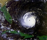
All Topics  
Hurricane Andrew

 
Hurricane Andrew

   Email Print
   Bookmark   Link


Hurricane Andrew


Hurricane Andrew is the second most powerful, and the last of three Category 5
Saffir-Simpson Hurricane Scale

The Saffir-Simpson Hurricane Scale is a classification used for most Western Hemisphere tropical cyclones that exceed the intensities of tropical depressions and tropical storms, and thereby become hurricanes....
 hurricanes that made U.S. landfall
Landfall (meteorology)

Landfall is the event of a tropical cyclone or a waterspout coming onto land after being over water. When a waterspout makes landfall it is reclassified as a tornado, which can then cause damage inland....
 during the 20th century, after the Labor Day Hurricane of 1935
Labor Day Hurricane of 1935

The Labor Day Hurricane of 1935 was the strongest tropical cyclone during the 1935 Atlantic hurricane season. The second tropical cyclone, second hurricane, and second Saffir-Simpson Hurricane Scale of the season was the most intense List of Category 5 Atlantic hurricanes that affected the United States, and it was the first of three Category...
 and Hurricane Camille
Hurricane Camille

Hurricane Camille was the third and strongest tropical cyclone and second hurricane during the 1969 Atlantic hurricane season. The second of three catastrophic-level Saffir-Simpson Hurricane Scale hurricanes to make landfall in the United States during the 20th century, which it did near the mouth of the Mississippi River on the night of Aug...
 in 1969. Andrew caused 65 deaths,

The first named storm of the 1992 Atlantic hurricane season
1992 Atlantic hurricane season

The 1992 Atlantic hurricane season officially began on June 1, 1992, and lasted until November 30, 1992. These dates conventionally delimit the period of each year when most tropical cyclones form in the Atlantic basin....
, Andrew struck the northwestern Bahamas, southern Florida
Florida

Florida is a U.S. state located in the Southeastern United States of the United States, bordering Alabama to the northwest and Georgia to the northeast....
 at Homestead
Homestead, Florida

Homestead is a city in Miami-Dade County, Florida, Florida, United States nestled between Biscayne National Park to the east and Everglades National Park to the west....
 (south of Miami
Miami, Florida

Miami is a global city in southeastern Florida, in the United States. Miami is the county seat of Miami-Dade County, Florida, the most populous county in Florida....
), and southwest Louisiana
Louisiana

The State of Louisiana is a U.S. state located in the U.S. Southern States of the United States of America. Its capital is Baton Rouge and largest city is New Orleans....
 around Morgan City
Morgan City, Louisiana

Morgan City is a city in St. Martin Parish, Louisiana and St. Mary Parish, Louisiana parishes in the U.S. state of Louisiana. The population was 12,703 at the 2000 United States Census....
 in August. Andrew caused $26.5 billion in damage ($38.1 billion in 2006 US dollars), with most of that damage cost in south Florida.


Discussion
Ask a question about 'Hurricane Andrew'
Start a new discussion about 'Hurricane Andrew'
Answer questions from other users
Full Discussion Forum


Encyclopedia


Hurricane Andrew is the second most powerful, and the last of three Category 5
Saffir-Simpson Hurricane Scale

The Saffir-Simpson Hurricane Scale is a classification used for most Western Hemisphere tropical cyclones that exceed the intensities of tropical depressions and tropical storms, and thereby become hurricanes....
 hurricanes that made U.S. landfall
Landfall (meteorology)

Landfall is the event of a tropical cyclone or a waterspout coming onto land after being over water. When a waterspout makes landfall it is reclassified as a tornado, which can then cause damage inland....
 during the 20th century, after the Labor Day Hurricane of 1935
Labor Day Hurricane of 1935

The Labor Day Hurricane of 1935 was the strongest tropical cyclone during the 1935 Atlantic hurricane season. The second tropical cyclone, second hurricane, and second Saffir-Simpson Hurricane Scale of the season was the most intense List of Category 5 Atlantic hurricanes that affected the United States, and it was the first of three Category...
 and Hurricane Camille
Hurricane Camille

Hurricane Camille was the third and strongest tropical cyclone and second hurricane during the 1969 Atlantic hurricane season. The second of three catastrophic-level Saffir-Simpson Hurricane Scale hurricanes to make landfall in the United States during the 20th century, which it did near the mouth of the Mississippi River on the night of Aug...
 in 1969. Andrew caused 65 deaths,

The first named storm of the 1992 Atlantic hurricane season
1992 Atlantic hurricane season

The 1992 Atlantic hurricane season officially began on June 1, 1992, and lasted until November 30, 1992. These dates conventionally delimit the period of each year when most tropical cyclones form in the Atlantic basin....
, Andrew struck the northwestern Bahamas, southern Florida
Florida

Florida is a U.S. state located in the Southeastern United States of the United States, bordering Alabama to the northwest and Georgia to the northeast....
 at Homestead
Homestead, Florida

Homestead is a city in Miami-Dade County, Florida, Florida, United States nestled between Biscayne National Park to the east and Everglades National Park to the west....
 (south of Miami
Miami, Florida

Miami is a global city in southeastern Florida, in the United States. Miami is the county seat of Miami-Dade County, Florida, the most populous county in Florida....
), and southwest Louisiana
Louisiana

The State of Louisiana is a U.S. state located in the U.S. Southern States of the United States of America. Its capital is Baton Rouge and largest city is New Orleans....
 around Morgan City
Morgan City, Louisiana

Morgan City is a city in St. Martin Parish, Louisiana and St. Mary Parish, Louisiana parishes in the U.S. state of Louisiana. The population was 12,703 at the 2000 United States Census....
 in August. Andrew caused $26.5 billion in damage ($38.1 billion in 2006 US dollars), with most of that damage cost in south Florida. Its central pressure ranks as fourth-lowest in U.S. landfall records and Andrew was the costliest natural disaster in U.S. history until surpassed by Hurricane Katrina
Hurricane Katrina

Hurricane Katrina of the 2005 Atlantic hurricane season was the costliest Atlantic hurricane, as well as one of the five deadliest, in the history of the United States....
 of the 2005 season
2005 Atlantic hurricane season

The 2005 Atlantic hurricane season was the most active List of Atlantic hurricane seasons in recorded history, repeatedly shattering previous records....
. It was also the first of two Category 4 or higher storms to strike the United States that year (Hurricane Iniki
Hurricane Iniki

Hurricane Iniki was the most powerful hurricane to strike the U.S. state of Hawaii and the Hawaiian Islands in recorded history. Forming during the strong El Ni?o-Southern Oscillation of 1991?1994, Iniki was one of eleven Central Pacific tropical cyclones during the 1992 Pacific hurricane season....
 in the Central Pacific struck Hawaii a couple of weeks later).

Meteorological history

Hurricaneandrew
A tropical wave
Tropical wave

Tropical waves, or easterly waves, also known as African easterly waves in the Atlantic region, are a type of atmospheric Trough , an elongated area of relatively Low pressure area, oriented north to south, which move from east to west across the tropics causing areas of cloudiness and thunderstorms....
 moved off the coast of Africa on August 14. Under the influence of a ridge
Ridge (meteorology)

A ridge is an elongated region of relatively high atmospheric pressure, the opposite of a Trough .See also* Geopotential height* Block ...
 of high pressure to its north, the wave tracked quickly westward. An area of convection
Convection

Convection in the most general terms refers to the movement of molecules within fluids . Convection is one of the major modes of heat transfer and mass transfer....
 developed along the wave axis to the south of the Cape Verde
Cape Verde

The Republic of Cape Verde , is an archipelago nation located in the Macaronesia ecoregion of the North Atlantic Ocean, off the western coast of Africa....
 islands, and on August 15 meteorologists began classifying the system with the Dvorak technique
Dvorak technique

The Dvorak technique is a widely used system to subjectively estimate tropical cyclone intensity based solely on visible and infrared Weather satellite....
. The thunderstorm activity became more concentrated, and narrow spiral rainbands
Tropical cyclone

A tropical cyclone is a storm characterized by a large low pressure system center and numerous thunderstorms that produce strong winds and flooding rain....
 developed around a developing center of circulation. Based on a Dvorak T-number of 2.0, it is estimated Tropical Depression Three developed late on August 16 about 1630 miles (2625 km) eastsoutheast of Barbados
Barbados

Barbados , situated just east of the Caribbean Sea, is an independent Continental Island-island nation in the western Atlantic Ocean. Located at roughly 13? North of the equator and 59? West of the prime meridian, it is considered a part of the Lesser Antilles....
.

Embedded within the deep easterlies, the depression tracked westnorthwestward at 20 mph (33 km/h). Initially, moderate wind shear
Wind shear

Wind shear, sometimes referred to as windshear or wind gradient, is a difference in wind wind speed and wind direction over a relatively short distance in the Earth's atmosphere....
 prevented strengthening, though a decrease in shear allowed the depression to intensify into Tropical Storm Andrew at around 1200 UTC on August 17. By early on August 18, the storm maintained concentrated convection near the center with spiral bands to its west as the winds increased to 50 mph (85 km/h). Shortly thereafter the thunderstorms decreased markedly during the diurnal minimum, and as the storm turned to the northwest increased southwesterly wind shear from an upper-level low prevented Andrew from maintaining deep convection. On August 19, a Hurricane Hunters
Hurricane Hunters

Hurricane Hunters are aircraft that fly into tropical cyclones in the North Atlantic Ocean and Northeastern Pacific Ocean for the specific purpose of directly measuring weather data in and around those storms....
 flight into the storm failed to locate a well-defined center, and the next day a flight found that the cyclone had degenerated to the extent that only a diffuse low-level circulation center remained; observations indicated the pressure rose to an unusually high 1015 mbar
Bar (unit)

The bar , decibar and the millibar are units of pressure. They are not SI units, nor are they cgs units, but they are accepted for use with the SI....
. The flight indicated Andrew maintained a vigorous circulation aloft, with winds of 80 mph (130 km/h) recorded at flight level. Subsequently, the upper-level low weakened and split into a trough
Trough (meteorology)

A trough is an elongated region of relatively low atmospheric pressure, often associated with weather fronts.Unlike fronts, there is not a universal symbol for a trough on a weather chart....
, which decreased the wind shear over the storm. Simultaneously, a strong high pressure cell developed over the southeastern United States, which built eastward and caused Andrew to turn to the west. Convection became more organized as upper-level outflow
Outflow (meteorology)

Outflow, in meteorology, is air that flows outwards from a thunderstorm. Outflow tends to indicate the "health" of a system. Large quantities of outflow at the upper levels of a thunderstorm indicate it is in good health....
 became better established. An eye
Eye (cyclone)

The eye is a region of mostly calm weather found at the center of strong tropical cyclones. The eye of a storm is a roughly circular area and typically 30?65 km in diameter....
 formed, and Andrew attained hurricane status early on August 22 while located about 650 miles (1040 km) eastsoutheast of Nassau, Bahamas
Nassau, Bahamas

Nassau is the Capital , largest city, and commercial centre of the Commonwealth of the Bahamas. The city has a population of 260,000 , nearly 80 percent of the entire population of The Bahamas ....
.

Six hours after becoming a hurricane, Andrew was predicted to make landfall
Landfall (meteorology)

Landfall is the event of a tropical cyclone or a waterspout coming onto land after being over water. When a waterspout makes landfall it is reclassified as a tornado, which can then cause damage inland....
 near Jupiter, Florida
Jupiter, Florida

.Jupiter is a town located in Palm Beach County, Florida. As of the 2000 census, the town had a total population of 39,328. As of 2006, the population had grown to 50,028, according to the University of Florida, Bureau of Economic and Business Research....
 with winds of 105 mph (165 km/h). The hurricane accelerated as it tracked due westward into an area of very favorable conditions, and late on August 22 began rapidly intensifying
Rapid deepening

Rapid deepening, also known as rapid intensification, is a meteorology condition that occurs when the minimum sea-level atmospheric pressure of a tropical cyclone decreases drastically in a short period of time....
; in a 24 hour period the pressure dropped 47 mbar
Bar (unit)

The bar , decibar and the millibar are units of pressure. They are not SI units, nor are they cgs units, but they are accepted for use with the SI....
 to a minimum pressure of 922 mbar. On August 23 the cyclone attained Category 5
List of Category 5 Atlantic hurricanes

This is a list of all recorded Atlantic hurricanes that have reached Category 5, the highest classification of tropical cyclone intensity on the Saffir-Simpson Hurricane Scale....
 status on the Saffir-Simpson Hurricane Scale
Saffir-Simpson Hurricane Scale

The Saffir-Simpson Hurricane Scale is a classification used for most Western Hemisphere tropical cyclones that exceed the intensities of tropical depressions and tropical storms, and thereby become hurricanes....
, and at 1800 UTC Hurricane Andrew reached peak winds of 175 mph (280 km/h) while located a short distance off Eleuthera
Eleuthera

See also: EleutheraeEleuthera is an island in the Bahamas, lying 50 miles east of Nassau, Bahamas. It is very long and thin—110 miles long and in places little more than a mile wide....
 island in the Bahamas. Operationally, the National Hurricane Center
National Hurricane Center

The National Hurricane Center , located at Florida International University in Miami, Florida, is the division of National Weather Service's Tropical Prediction Center responsible for tracking and predicting the likely behavior of tropical depressions, tropical storms and tropical cyclone....
 assessed its peak intensity as 150 mph (240 km/h), which was upgraded to 155 mph (250 km/h) in post-analysis; the hurricane was re-classified as a Category 5 hurricane twelve years subsequent to the hurricane. A small tropical cyclone, winds of 35 mph (55 km/h) extended out only about 90 miles (150 km) from its center. Subsequent to peaking in intensity, the hurricane underwent an eyewall replacement cycle
Eye (cyclone)

The eye is a region of mostly calm weather found at the center of strong tropical cyclones. The eye of a storm is a roughly circular area and typically 30?65 km in diameter....
, and at 2100 UTC on August 23, Hurricane Andrew struck Eleuthera with winds of 160 mph (260 km/h). The cyclone weakened further while crossing the Bahama Banks
Bahama Banks

The Bahama Banks are the submerged carbonate platforms that make up much of the Bahamas Archipelago. The term is usually applied in referring to either the Great Bahama Bank around Andros Island, or the Little Bahama Bank of Grand Bahama Island and Great Abaco, which are the largest of the platforms, and the Cay Sal Bank north of Cuba....
, and at 0100 UTC on August 24 Andrew hit the southern Berry Islands
Berry Islands

The Berry Islands are a chain of islands and a Districts of the Bahamas of the Bahamas, covering about thirty square miles of the north western part of the Out Islands....
 of the Bahamas with winds of 150 mph (240 km/h). As it crossed over the warm waters of the Gulf Stream
Gulf Stream

The Gulf Stream, together with its northern extension towards Europe, the North Atlantic Current, is a powerful, warm, and swift Atlantic Ocean ocean current that originates in the Gulf of Mexico, exits through the Straits of Florida, and follows the eastern coastlines of the United States and Newfoundland and Labrador before crossing the At...
 in the Straits of Florida
Straits of Florida

The Straits of Florida, Florida Straits, or Florida Strait is a strait located south-southeast of the North American mainland, generally accepted to be between the Gulf of Mexico and the Atlantic Ocean, and between the Florida Keys and Cuba....
, the hurricane rapidly re-intensified as the eye decreased in size and its eyewall convection deepened. At 0840 UTC on August 24, Andrew struck Elliott Key
Elliott Key

Elliott Key is the northernmost of the true Florida Keys , and the largest key north of Key Largo. It is located entirely within Biscayne National Park, in Miami-Dade County, Florida, east of Homestead, Florida, at coordinates ....
 with winds of 165 mph (270 km/h) and a pressure of 926 mbar. The hurricane continued to strengthen up to and slightly after landfall, and 25 minutes after its first Florida
Florida

Florida is a U.S. state located in the Southeastern United States of the United States, bordering Alabama to the northwest and Georgia to the northeast....
 landfall Andrew hit near Homestead
Homestead, Florida

Homestead is a city in Miami-Dade County, Florida, Florida, United States nestled between Biscayne National Park to the east and Everglades National Park to the west....
 with a slightly lower pressure and winds of 150mph.

As the eye moved onshore, the convection in the eyewall strengthened owing to increased convergence, and Hurricane Hunters reported a warmer eyewall temperature than two hours prior. However, Hurricane Andrew weakened as the eye continued further inland, and after crossing southern Florida in four hours, the eye emerged into the Gulf of Mexico
Gulf of Mexico

The Gulf of Mexico is the ninth largest body of water in the world. Considered a smaller part of the Atlantic Ocean, it is an oceanic basin largely surrounded by the North American continent and the island of Cuba....
 with winds of 135 mph (215 km/h). The eye remained well-defined as the hurricane turned to the westnorthwest, a change due to the weakening of the ridge to its north. Andrew steadily re-intensified over the Gulf of Mexico, reaching winds of 145 mph (235 km/h) by late on August 25. As the high pressure system to its north weakened, a strong mid-latitude trough
Trough (meteorology)

A trough is an elongated region of relatively low atmospheric pressure, often associated with weather fronts.Unlike fronts, there is not a universal symbol for a trough on a weather chart....
 approached the area from the northwest. This caused the hurricane to decelerate to the northwest, and winds decreased as Andrew approached the Gulf Coast of the United States
Gulf Coast of the United States

The Gulf Coast region of the United States comprises the coasts of states which border the Gulf of Mexico. The states of Texas, Louisiana, Mississippi, Alabama, and Florida are known as the Gulf States....
. At 0830 UTC on August 26 the cyclone made its final landfall in a sparsely populated area of Louisiana
Louisiana

The State of Louisiana is a U.S. state located in the U.S. Southern States of the United States of America. Its capital is Baton Rouge and largest city is New Orleans....
 about 20 miles (32 km) westsouthwest of Morgan City
Morgan City, Louisiana

Morgan City is a city in St. Martin Parish, Louisiana and St. Mary Parish, Louisiana parishes in the U.S. state of Louisiana. The population was 12,703 at the 2000 United States Census....
 with winds of 115 mph (185 km/h). Hurricane Andrew weakened rapidly as it turned to the north and northeast, and within ten hours weakened to a tropical storm. After entering Mississippi
Mississippi

Mississippi is a U.S. state located in the Deep South of the United States. Jackson, Mississippi is the state capital and largest city. The state's name comes from the Mississippi River, which flows along its western boundary, and takes its name from the Anishinaabe language word misi-ziibi ....
, the cyclone deteriorated to tropical depression status early on August 27. Accelerating northeastward, the tropical depression began merging with the approaching frontal system, and by midday on August 28 Andrew ceased to meet the qualifications of a tropical cyclone while located over the southern Appalachian Mountains
Appalachian Mountains

The Appalachian Mountains or , often called the Appalachians, are a vast mountain range in eastern North America. Definitions vary on the precise boundaries of the Appalachians....
. The remnants continued to the northeast and lost its identity within the frontal zone over the Mid-Atlantic states
Mid-Atlantic States

The Mid-Atlantic States form one of the nine geographic divisions within the United States that are officially recognized by the United States Census Bureau....
.

Statistics

Reports from private barometers helped establish that Andrew's central pressure, at landfall near Homestead, Florida
Homestead, Florida

Homestead is a city in Miami-Dade County, Florida, Florida, United States nestled between Biscayne National Park to the east and Everglades National Park to the west....
, was 27.23 inches (922 hPa
Pascal (unit)

The pascal is the SI derived unit of pressure, stress , Young's modulus and tensile strength. It is a measure of force per unit area i.e. equivalent to one newton per square meter or one joule per cubic meter....
). At the time, this was the third-lowest pressure on record for a landfalling hurricane in the United States (it is now fourth, after 2005's Hurricane Katrina
Hurricane Katrina

Hurricane Katrina of the 2005 Atlantic hurricane season was the costliest Atlantic hurricane, as well as one of the five deadliest, in the history of the United States....
).

Andrew's peak winds in South Florida were not directly measured, primarily because of the destruction or failure of measuring instruments. The Coastal Marine Automated Network (C-MAN) station at Fowey Rocks, with platform elevation of 141 ft (43 m), in its last transmission at 4:30 a.m. EDT, August 24, recorded an 8-minute average wind of 142 mph
Miles per hour

The mile per hour is a physical unit of speed, expressing the number of Mile covered per hour.It is currently the Unit of measurement used for speed limits, and speeds, on roads in the United Kingdom and United States....
 (228 km/h) with a peak gust of 169 mph
Miles per hour

The mile per hour is a physical unit of speed, expressing the number of Mile covered per hour.It is currently the Unit of measurement used for speed limits, and speeds, on roads in the United Kingdom and United States....
 (272 km/h) shortly before the equipment was destroyed. It is probable that higher winds occurred at Fowey Rocks after the station was destroyed.

Another important wind speed report came from the Kendall-Tamiami Executive Airport, located nine miles (14 km) west of the shoreline. While weather observations had been suspended at the station, the official weather observer there stayed on duty and continued to make wind speed readings. At 4:45 a.m. EDT, August 24, he noted that the wind speed indicator was "pegged" at a position a little beyond the instrument's highest value of 100 knots (115 mph
Miles per hour

The mile per hour is a physical unit of speed, expressing the number of Mile covered per hour.It is currently the Unit of measurement used for speed limits, and speeds, on roads in the United Kingdom and United States....
, 185 km/h), at a point he estimated to be around 110 knots (125 mph
Miles per hour

The mile per hour is a physical unit of speed, expressing the number of Mile covered per hour.It is currently the Unit of measurement used for speed limits, and speeds, on roads in the United Kingdom and United States....
, 205 km/h). The needle reportedly remained "fixed" at this location for 3-5 minutes before dropping to "0" when the anemometer failed. These observations were closely corroborated by two other observers. He also indicated that the weather conditions continued to worsen for an additional 30 minutes after the anemometer failed. It is probable that much stronger winds occurred at this location.

The highest recorded surface gust, within Andrew's northern eyewall, occurred at the home of a resident about a mile from the shoreline in Perrine, Florida
Perrine, Florida

Perrine, Florida was an unincorporated area community in Miami-Dade County, Florida about midway between Miami, Florida and Homestead, Florida. It is located at The community was named after Dr....
. During the peak of the storm, a gust of 212 mph
Miles per hour

The mile per hour is a physical unit of speed, expressing the number of Mile covered per hour.It is currently the Unit of measurement used for speed limits, and speeds, on roads in the United Kingdom and United States....
 (341 km/h) was observed before both the home and anemometer were destroyed. Subsequent wind-tunnel testing at Clemson University
Clemson University

Clemson University is a state university , coeducational, Land-grant_university, research university located in Clemson, South Carolina, South Carolina, United States....
 of the same type of anemometer revealed a 16.5% error. The observed value was officially corrected to be 177 mph
Miles per hour

The mile per hour is a physical unit of speed, expressing the number of Mile covered per hour.It is currently the Unit of measurement used for speed limits, and speeds, on roads in the United Kingdom and United States....
 (285 km/h).

Data collected at the Turkey Point Nuclear Generating Station
Turkey Point Nuclear Generating Station

Turkey Point Nuclear Generating Station is a twin reactor nuclear power station located on a 3,300-acre site 2 miles east of Homestead, Florida, United States, next to Biscayne National Park located about 25 miles south of Miami, Florida near the southernmost edge of Miami-Dade County....
 terminated at 5:05 EDT before winds reached maximum strength. The anemometer recorded sustained winds of 145 mph
Miles per hour

The mile per hour is a physical unit of speed, expressing the number of Mile covered per hour.It is currently the Unit of measurement used for speed limits, and speeds, on roads in the United Kingdom and United States....
 before it failed, and a barometric pressure of 922 mb was recorded (equal to the lowest observed surface pressure of 922 mb recorded in Perrine at a private home). Gusts exceeding 175 mph
Miles per hour

The mile per hour is a physical unit of speed, expressing the number of Mile covered per hour.It is currently the Unit of measurement used for speed limits, and speeds, on roads in the United Kingdom and United States....
 were also observed. The data from Turkey Point reflects shoreline measurements (not inland), as it is situated directly on the coastline.

A National Weather Service-Miami Radar image recorded on 24 August 1992 at 4:35 EDT [08:35 UTC] superimposed on a street map by the Hurricane Research Division of NOAA cleary indicates the most powerful winds within the northern eyewall (conditions greater than 48 dBZ) made landfall between SW 152 St. (Coral Reef Drive) and SW 184 St. (Eureka Drive) in the Perrine/Cutler Ridge area. dBZ readings indicate Decibels of Z (radar echo intensity/reflectivity) and help map the relative strength of storm activity within a weather system. This extremely powerful band within the northern eyewall corresponds with the exact latitude range where the highest surface wind gusts of 177 mph
Miles per hour

The mile per hour is a physical unit of speed, expressing the number of Mile covered per hour.It is currently the Unit of measurement used for speed limits, and speeds, on roads in the United Kingdom and United States....
 and lowest barometric pressure (922 mb) were recorded at a private home in Perrine and evaluated by Clemson University. This corridor is also in line with the former Burger King corporate headquarters, located on the shoreline at the terminus of 184th St. (Eureka Drive), where one of the highest storm surge levels was recorded (16.9 ft).

In 2002, The Atlantic Basin Hurricane Database Reanalysis Project examined Hurricane Andrew and this corridor of extreme winds embedded within Andrew's northern eyewall. The project concluded that Category 5 conditions on land occurred only in a small region of southern Dade (now Miami-Dade) County, specifically close to the coast in Cutler Ridge. The remaining areas affected by Andrew's initial landfall in Florida likely experienced sustained Category 4 and 3 conditions. Andrew was officially re-classified as a Category 5 storm in 2004, and the reanalysis provides a more comprehensive and detailed examination of Andrew's wind field structure upon landfall than originally assessed in 1992.

The National Hurricane Center
National Hurricane Center

The National Hurricane Center , located at Florida International University in Miami, Florida, is the division of National Weather Service's Tropical Prediction Center responsible for tracking and predicting the likely behavior of tropical depressions, tropical storms and tropical cyclone....
, then located along U.S. 1 in Coral Gables, recorded a peak gust of 164 mph
Miles per hour

The mile per hour is a physical unit of speed, expressing the number of Mile covered per hour.It is currently the Unit of measurement used for speed limits, and speeds, on roads in the United Kingdom and United States....
 (272 km/h) measured 130 ft (39.6 m) above the ground, just before 5 a.m. EDT, August 24. At 5:17 a.m. EDT, the anemometer was severely damaged and by 5:45 a.m. had been completely destroyed.

High winds occurred in other locations across Southern Florida, including peak gusts of 115 mph
Miles per hour

The mile per hour is a physical unit of speed, expressing the number of Mile covered per hour.It is currently the Unit of measurement used for speed limits, and speeds, on roads in the United Kingdom and United States....
 (185 km/h) estimated at Miami International Airport
Miami International Airport

Miami International Airport is a public airport located eight miles northwest of the central business district of Miami, Florida, in unincorporated area Miami-Dade County, Florida, United States....
 and 132 mph
Miles per hour

The mile per hour is a physical unit of speed, expressing the number of Mile covered per hour.It is currently the Unit of measurement used for speed limits, and speeds, on roads in the United Kingdom and United States....
 (212 km/h) recorded at Haulover Beach, Florida
Baker's Haulover Inlet

Baker's Haulover Inlet is a man-made channel in Miami-Dade County, Florida connecting the northern end of Biscayne Bay with the Atlantic Ocean, at coordinates ....
.

In 2002, as part of an ongoing review of historical hurricane records, National Hurricane Center experts concluded that Andrew had sustained winds of 165 mph
Miles per hour

The mile per hour is a physical unit of speed, expressing the number of Mile covered per hour.It is currently the Unit of measurement used for speed limits, and speeds, on roads in the United Kingdom and United States....
 (265 km/h) briefly before and during landfall, making it a Category 5.

Berwick, Louisiana
Berwick, Louisiana

Berwick is a town in St. Mary Parish, Louisiana, Louisiana, United States. The population was 4,418 at the 2000 United States Census. It is part of the Morgan City, Louisiana Micropolitan Statistical Area....
 reported sustained winds of 96 mph
Miles per hour

The mile per hour is a physical unit of speed, expressing the number of Mile covered per hour.It is currently the Unit of measurement used for speed limits, and speeds, on roads in the United Kingdom and United States....
 (154 km/h) with gusts to 120 mph
Miles per hour

The mile per hour is a physical unit of speed, expressing the number of Mile covered per hour.It is currently the Unit of measurement used for speed limits, and speeds, on roads in the United Kingdom and United States....
 (193 km/h). The highest gust of 173 mph (278 km/h) was reported from a drilling barge on Bayou Teche in coastal St. Mary Parish
St. Mary Parish, Louisiana

St. Mary Parish is a parish located in the U.S. state of Louisiana. The parish seat is Franklin, Louisiana. As of 2000, the population was 53,500....
, Louisiana
Louisiana

The State of Louisiana is a U.S. state located in the U.S. Southern States of the United States of America. Its capital is Baton Rouge and largest city is New Orleans....
.

Preparations

Before impact in the Bahamas predictions were for a 10 to storm surge
Storm surge

Storm surge is an offshore rise of water associated with a low pressure area weather system, typically a tropical cyclone. Storm surge is caused primarily by high winds pushing on the ocean's surface....
, rising locally to , and for 5 to of rain. Evacuations were ordered by emergency management officials, and at 5 PM local time residents throughout the region of Bahamas and Florida were warned to take precautions to protect life and property. By 11 PM local time, residents were warned that precautions to protect life and property should have been completed. A 7 to storm surge was predicted for Eastern Florida and the Florida Keys, and a 7 to storm surge was predicted for Western Florida was predicted before the storm exited Florida. Some isolated tornadoes were also predicted for South and Central Florida for August 23 and August 24. At least 1,500 National Guard
United States National Guard

The National Guard of the United States is a Military reserve force composed of U.S. state National Guard militia members or units under federally recognized active or inactive Military of the United States service for the United States ....
 troops were deployed to Florida to prevent looting. Sandbag walls were created in the South Bell Telephone Building in New Orleans. Sandbag walls were also created in the French Quarter
French Quarter

The French Quarter, also known as Vieux Carr?, is the oldest and most famous New Orleans neighborhoods in the city of New Orleans, Louisiana....
 section of New Orleans. Floodgates were also closed throughout New Orleans Levees. Sandbags for the public ran out because of the protection of major areas. Planes headed to and from New Orleans were canceled.

Impact


Bahamas

Hurricane Andrew passed through the Bahamas as a Category 5 hurricane,, with a wind gust of 138 mph (223 km/h) recorded on Eleuthera Island before the instrument failed. A storm surge
Storm surge

Storm surge is an offshore rise of water associated with a low pressure area weather system, typically a tropical cyclone. Storm surge is caused primarily by high winds pushing on the ocean's surface....
 of 23 ft (7 m) was recorded, which caused significant flooding. In the country, the hurricane caused four deaths, including one indirectly, and damage totaled $250 million (1992 USD).

Florida

Destruction Following Hurricane Andrew
As with most high-intensity storms man (Categories 4 and 5), the worst damage from Andrew is thought to have occurred not from straight-line winds but from vortices, or tornadoes or "miniwhirls" (something like embedded tornadoes). This was the conclusion of Tetsuya Theodore Fujita, a University of Chicago
University of Chicago

The University of Chicago is a private university located principally in the Hyde Park, Chicago neighborhood of Chicago. Although an older university by the same name existed prior to its founding, the modern University of Chicago credits its founding to the oil magnate John D....
 meteorologist who devised the Fujita scale
Fujita scale

The Fujita scale , or Fujita-Pearson scale, is a scale for rating tornado intensity, based on the damage tornadoes inflict on human-built structures and vegetation....
 for measuring the strength of tornadoes, after he surveyed Andrew's destruction in the Homestead area.

Looting also occurred in Florida after the storm, with at least 100 people attempting to ransack the Cutler Ridge shopping mall south of Miami. However, the deployment of 600 National Guard troops in the region restored order.

Andrew produced a 17 ft (5.2 m) storm surge
Storm surge

Storm surge is an offshore rise of water associated with a low pressure area weather system, typically a tropical cyclone. Storm surge is caused primarily by high winds pushing on the ocean's surface....
 near the landfall point in Florida. A tidal surge of was recorded at the shoreline of SW 184th Street (Eureka Drive), the former location of the Burger King world corporate headquarters on the coast of the Perrine/Cutler Ridge area (directly within the path of the northern eyewall). Storm surge destruction was minimal, though, because of Andrew not moving over Miami itself.

Rainfall was limited in Southeast Florida because of Andrew traveling through at fast speeds (between 20 and 25 mph forward speed).

Unlike most hurricanes, the vast majority of the damage in Florida was due to the winds. The agricultural loss in Florida was $1.04 billion alone.

In Dade County
Miami-Dade County, Florida

Miami-Dade County is a county located in the southeastern part of the U.S. state of Florida. The United States Census Bureau estimates that the county population was 2,387,170 in 2007, making it the most populous county in Florida and the List of the most populous counties in the United States....
 90% of homes had major roof damage. 117,000 were destroyed or had major damage.

The Turkey Point Nuclear Generating Station
Turkey Point Nuclear Generating Station

Turkey Point Nuclear Generating Station is a twin reactor nuclear power station located on a 3,300-acre site 2 miles east of Homestead, Florida, United States, next to Biscayne National Park located about 25 miles south of Miami, Florida near the southernmost edge of Miami-Dade County....
 was hit directly by Andrew. Over $90 million of damage was done, largely to a water tank and to a smokestack of one of the fossil-fueled units on-site, but the containment building
Containment building

A containment building, in its most common usage, is a steel or Reinforced concrete structure enclosing a nuclear reactor. It is designed to, in any emergency, contain the escape of radiation to a maximum pressure in the range of 60 to 200 psi ....
s were undamaged. The nuclear plant was built to withstand winds of up to 235 mph.
Andrew1992rain
Massive damage caused by Andrew at Homestead Air Force Base
Homestead Air Reserve Base

Homestead Joint Air Reserve Base , is a United States Air Force base located in South Miami-Dade County, Florida adjacent to the city of Homestead, Florida....
, very near the point of landfall on the South Florida coast, led to the closing of the base as a full active-duty base. It was later partly rebuilt and operates today as a U.S. Air Reserve base. The aircraft and squadron were relocated to Aviano Air Base
Aviano Air Base

File:Aviano F-16.JPGFile:F-16C-510th-Fighter-Squadron.jpgAviano Air Base is a NATO airbase in northeastern Italy, in Friuli-Venezia Giulia Regions of Italy....
 in Italy.

Power lines to the Florida Keys
Florida Keys

The Florida Keys are an archipelago of about 1700 islands in the southeast United States. They begin at the southeastern tip of the Florida peninsula, about south of Miami, Florida, and extend in a gentle arc south-southwest and then westward to Key West, Florida, the westernmost of the inhabited islands, and on to the uninhabited Dry Tort...
 were destroyed, leaving residents without power. However water was maintained, although it had to be boiled
Boiling

Boiling, a type of phase transition, is the rapid vaporization of a liquid, which typically occurs when a liquid is heated to its boiling point, the temperature at which the vapor pressure of the liquid is equal to the pressure exerted on the liquid by the surrounding environmental pressure....
.

There was also moderate damage to the coral reef
Coral reef

Coral reefs are aragonite structures produced by living organisms. In most reefs the predominant organisms are colonial cnidarian that secrete an exoskeleton of calcium carbonate....
 areas offshore of Florida down to depths of .

Louisiana

After hitting Florida, Andrew moved across the Gulf of Mexico and once again made landfall in south-central Louisiana
Louisiana

The State of Louisiana is a U.S. state located in the U.S. Southern States of the United States of America. Its capital is Baton Rouge and largest city is New Orleans....
. About 152,000 electricity customers lost their power because of the impact of Andrew. Four people were also killed, as a result of Andrew.

Storm tide
Storm tide

A storm tide is a tide with a high flood period caused by a storm. Storm tides can be a severe danger to the coast and the people living along the coast....
s of at least eight ft (2.4 m) inundated portions of the Louisiana coast. Andrew also produced a killer tornado
Tornado

A tornado is a violent, rotating column of air which is in contact with both the surface of the earth and a cumulonimbus cloud or, in rare cases, the base of a cumulus cloud....
 in southeastern Louisiana. The F3 tornado hit Laplace
Laplace, Louisiana

LaPlace is a census-designated place in St. John the Baptist Parish, Louisiana, Louisiana, United States, along the east bank of the Mississippi River in the New Orleans metropolitan area....
 and stayed on ground until Reserve
Reserve, Louisiana

Reserve is a census-designated place in St. John the Baptist Parish, Louisiana, Louisiana, United States, on the east bank of the Mississippi River....
, St. John the Baptist Parish
St. John the Baptist parish

St. John the Baptist parish may refer to one of a number of religious organisations:In the district of Clontarf, Dublin, Republic of Ireland:...
. The tornado caused two deaths.

Damage was done to soy bean, corn
Maize

Maize , known as corn in some countries, is a cereal domesticated in Mesoamerica and subsequently spread throughout the American continents....
, and sugar cane crops. The damage estimated done to the sugar cane was $200 million.

A Coast Guard
United States Coast Guard

The United States Coast Guard is a branch of the Military of the United States and one of seven Uniformed services of the United States. In addition to being a military branch at all times, it is unique among the armed forces in that it is also a Admiralty law agency and a Federal government of the United States regulatory agency....
 helicopter had to rescue 4 people and 2 dogs from a disabled fishing boat, south of Houma
Houma, Louisiana

Houma is the parish seat of Terrebonne Parish, Louisiana, Louisiana, United States, and the largest principal city of the Houma–Bayou Cane, Louisiana–Thibodaux, Louisiana Houma-Bayou Cane-Thibodaux metropolitan area....
.

Aftermath


Florida

Andrew's catastrophic damage spawned many rumors, including claims that hundreds or even thousands of migrant farm workers in south Dade County (now Miami-Dade County
Miami-Dade County, Florida

Miami-Dade County is a county located in the southeastern part of the U.S. state of Florida. The United States Census Bureau estimates that the county population was 2,387,170 in 2007, making it the most populous county in Florida and the List of the most populous counties in the United States....
) were killed and their deaths were not reported in official accounts. An investigation by the Miami Herald
The Miami Herald

The Miami Herald is a daily newspaper owned by The McClatchy Company headquartered in Downtown Miami Miami, Florida, Florida. It primarily serves Miami-Dade County, Florida, Broward County, Florida and Monroe County, Florida counties in the U.S....
 found no basis for such rumors. These rumors were probably based on the 1928 Okeechobee Hurricane
1928 Okeechobee Hurricane

The Okeechobee hurricane, or Hurricane San Felipe Segundo, was a deadly tropical cyclone that struck the Leeward Islands, Puerto Rico, the Bahamas, and Florida in September of the 1928 Atlantic hurricane season....
, when the deaths of migrant workers initially went uncounted, and were still debated at the time of Andrew.

The slow response of federal aid to storm victims in southern Florida led Dade County
Miami-Dade County, Florida

Miami-Dade County is a county located in the southeastern part of the U.S. state of Florida. The United States Census Bureau estimates that the county population was 2,387,170 in 2007, making it the most populous county in Florida and the List of the most populous counties in the United States....
 emergency management director Kate Hale to famously exclaim at a nationally televised news conference, "Where in the hell is the cavalry
Cavalry

The Cavalry is the second oldest of the Combat Arms, and as soldiers or warriors who fought mounted on horseback in combat, it represents the mobility and offensive power of the armed forces....
 on this one? They keep saying we're going to get supplies. For God's sake, where are they?" Almost immediately, President George H. W. Bush
George H. W. Bush

George Herbert Walker Bush served as the List of Presidents of the United States President of the United States from 1989 to 1993. Bush held a variety of political positions prior to his presidency, including Vice President of the United States in the administration of Ronald Reagan and Director of Central Intelligence under Gerald R....
 promised, "Help is on the way," and mobile kitchens and tents, along with units from the 82nd Airborne Division, began pouring in.

Insurance claims in the wake of the extreme damage caused by Andrew led to the bankruptcy and closure of 11 insurance agencies and drained an excessive amount of equity from 30 more. Nearly one million residences were no longer eligible for coverage by any insurance agency. This led the Florida Legislature to create new agencies (the Joint Underwriting Association, the Florida Windstorm Underwriting Association and the Florida Hurricane Catastrophe Fund) to restore adequate insurance coverage.

Homeowners and officials criticized developers and contractors for inadequate building practices and poor building codes. An inquiry after the storm concluded that there were probably construction flaws in some buildings, and that the state of Florida
Florida

Florida is a U.S. state located in the Southeastern United States of the United States, bordering Alabama to the northwest and Georgia to the northeast....
 did enforce some strict building codes since 1986, but they were either overlooked or ignored. However, the evidence was not sufficient enough to issue criminal charges for neglect.

The effects of Hurricane Andrew on Florida wetlands were considerable. In the Florida Everglades
Everglades

The Everglades are a tropics wetland located in the southern portion of the U.S. state of Florida, comprising the southern half of a large Drainage basin....
, 25%, 70,000 acres (280 kmē) of trees were knocked down by the storm. It took 20 days for new trees and vegetation to grow following the storms passing. Damage to marine life was moderate as the storm increased the turbidity and lowered the oxygen level in the water, threatening many fish and other marine wildlife. In addition, the storm killed 182 million fish in the basin, causing $160 million (1992 USD
United States dollar

The United States dollar is the unit of currency of the United States and was defined by the Coinage Act of 1792 to be between 371 and 416 grains of silver ....
) in lost value. In the decade after the storm, Hurricane Andrew may have contributed to the massive and sudden housing boom in Broward County, Florida
Broward County, Florida

Broward County is a county located in the U.S. state of Florida. As of 2000, the population is 1,623,018; this makes it the second most populated county in the state....
. Located just north of Miami-Dade County
Miami-Dade County, Florida

Miami-Dade County is a county located in the southeastern part of the U.S. state of Florida. The United States Census Bureau estimates that the county population was 2,387,170 in 2007, making it the most populous county in Florida and the List of the most populous counties in the United States....
, residents who had lost their homes migrated to western sections of the county that were just starting to be developed. The result was record growth in places like Miramar
Miramar, Florida

Miramar is a city in Broward County, Florida, Florida, United States. The city was named after the Miramar, Havana district of Havana, Cuba. As of 2007, the population estimated by the U.S....
, Pembroke Pines
Pembroke Pines, Florida

Pembroke Pines is a city in Broward County, Florida, Florida, United States. According to 2006 U.S. Census Bureau estimates, the city has a population of 150,064, making it the second most populous city in Broward County, the eleventh most populous in Florida, and the 157th most populous in the United States....
 and Weston
Weston, Florida

Weston is a city located in Broward County, Florida, USA. Established as a city in 1996, much of the community was developed by Arvida/JMB Realty and is located near the western developmental boundary of Broward County....
.

Louisiana

In Louisiana, the hurricane knocked down 80% of the trees in part of the Atchafalaya River
Atchafalaya River

The Atchafalaya River is a distributary of the Mississippi River and Red River rivers, approximately 170 miles long, in south central Louisiana in the United States....
 Basin
Drainage basin

A drainage basin is an extent of land where water from rain or snow melt drains downhill into a body of water, such as a river, lake, reservoir, estuary, wetland, sea or ocean....
 near the coast. Offshore, the storm killed 9.4 million fish, causing $7.8 million (1992 USD
United States dollar

The United States dollar is the unit of currency of the United States and was defined by the Coinage Act of 1792 to be between 371 and 416 grains of silver ....
) in lost value, and damaged large areas of marshland along the Louisiana
Louisiana

The State of Louisiana is a U.S. state located in the U.S. Southern States of the United States of America. Its capital is Baton Rouge and largest city is New Orleans....
 coast.

About 6,200 people had to be housed in 36 separate shelters, according to the American Red Cross
American Red Cross

The American Red Cross is a humanitarian organization that provides emergency assistance, disaster relief and education inside the United States, and is the designated U.S....
. The Salvation Army
Salvation Army

The Salvation Army, an international movement, is an evangelical part of the Christian Church. It has a quasi-military structure and it was founded in 1865 in Great Britian as the East London Christian Mission by William Booth and Catherine Booth....
 sent in 37 mobile food storage faculties, that served 40,000 meals, to help those who could get little or no food.

Federal aid, from the Pentagon, sent in four 750 kilowatt generators, 2,500 cots, and 30,000 MRE's, or prepackaged meals, to Louisiana. About 1,279 National Guard were deployed to Louisiana, to do various duties, from cooking to patrolling.

Sheriffs along the coast of Louisiana imposed a curfew from 6 p.m. to 6 a.m. local time
Central Time zone

The Central Time Zone is in the Americas and observes standard time by subtracting six hours from Coordinated Universal Time during standard time and five hours during daylight saving time ....
. Alcohol
Alcohol

In chemistry, an alcohol is any organic compound in which a hydroxyl Functional group is bound to a carbon atom of an alkyl or substituted alkyl group....
 sales were also banned immediately after the storm.

Retirement

Because of the exceptional and the widespread damage in Florida and Louisiana, the name "Andrew" was retired in 1993 and will never be used again for an Atlantic hurricane
Atlantic hurricane

North Atlantic tropical cyclones usually form in summer or autumn. Tropical cyclones can be broken down by intensity. Tropical storms have one-minute maximum sustained winds of at least 39 mph , while hurricanes have one-minute maximum sustained exceeding 74 mph ....
. The name was replaced by Alex for the 1998 season
1998 Atlantic hurricane season

The 1998 Atlantic hurricane season officially began on June 1, 1998, and lasted until November 30, 1998. These dates conventionally delimit the period of each year when most tropical cyclones form in the Atlantic basin; however, the season extended through December 1 as Hurricane Nicole remained active....
.

Further reading

Rick Gore: "Andrew aftermath" National Geographic Magazine
National Geographic Magazine

The National Geographic Magazine, later shortened to National Geographic, is the official journal of the National Geographic Society....
 April 1993

See also

  • List of Florida hurricanes
    List of Florida hurricanes

    The List of Florida hurricanes encompasses 485 Tropical cyclone or subtropical cyclones that affected the state of Florida. More storms hit Florida than any other U.S....
  • List of retired Atlantic hurricane names
  • List of Category 5 Atlantic hurricanes
    List of Category 5 Atlantic hurricanes

    This is a list of all recorded Atlantic hurricanes that have reached Category 5, the highest classification of tropical cyclone intensity on the Saffir-Simpson Hurricane Scale....
  • Timeline of the 1992 Atlantic hurricane season
    Timeline of the 1992 Atlantic hurricane season

    File:1992 Atlantic hurricane season map.pngThe 1992 Atlantic hurricane season was a below-average season that produced six named tropical cyclones. The season officially started on June 1, 1992 and finished on November 30; however, Subtropical Storm One formed outside the official timeline on April 21....
  • Hurricane Andrew, South Florida and Louisiana, August 23-26, 1992, report on the event by the NOAA
    National Oceanic and Atmospheric Administration

    The National Oceanic and Atmospheric Administration is a scientific agency within the United States Department of Commerce focused on the conditions of the oceans and the Earth's atmosphere....
     Disaster Survey Team


External links