
Hurricane Carol
Encyclopedia
Hurricane Carol was among the worst tropical cyclones to affect the New England
region of the United States
. It developed from a tropical wave
near the Bahamas on August 25, 1954, and gradually strengthened as it moved northwestward. On August 27, Carol intensified to reach winds of 105 mi/h, but weakened as its motion turned to a northwest drift. A strong trough
of low pressure turned the hurricane northeastward, and Carol intensified to attain Category 3 status on the Saffir–Simpson Hurricane Scale. The well-organized hurricane made landfall on Long Island
and Connecticut
on August 30 near peak intensity, and quickly became extratropical over land.
Carol was similar to the New England Hurricane of 1938
, as they were near the same intensity when affecting New England, in addition to both storms accelerating toward the region. Both systems hit within 40 miles (64.4 km) of each other at high tide, resulting in a substantial storm surge in Narragansett Bay. At the time, Carol was the third costliest United States hurricane, and the nineteenth costliest U.S. hurricane when adjusted for inflation, as of 2004.
developed into a tropical depression over the northeastern Bahamas on August 25. It moved to the northwest, and intensified into a tropical storm just six hours after forming. Receiving the name Carol, the storm gradually turned to the north, and strengthened under generally favorable conditions. On August 27, while located 345 miles (545 km) east of Cape Canaveral
, Florida
, Carol strengthened to attain hurricane status. With a large anticyclone
persisting across the southeastern United States
, the motion of Carol turned to a northwest drift. The hurricane continued to strengthen, and Carol reached an initial peak intensity of 105 mi/h late on August 27. After maintaining peak intensity for 30 hours and moving a distance of 77 miles (124 km), Carol weakened slightly off the coast of Georgia
.
An eastward moving deep-wave trough
intensified as it moved through the eastern United States
. This caused Carol to accelerate as it turned to the north and north-northeast. On August 30, the hurricane again strengthened to reach Category 2 status while located 180 miles (290 km) east of Savannah, Georgia
. Early on August 31, Carol passed very near Cape Hatteras
, North Carolina
with Reconnaissance Aircraft
intensity estimates between 75 mph (120 km/h) to 125 mph (200 km/h). The hurricane continued north-northeastward with a forward motion of up to 39 mph (63 km/h), and Carol intensified further to make landfall on eastern Long Island
(the eye going over the Fire Island community of Point O'Woods) as an upper Category 2 or a Category 3 hurricane. After quickly crossing the Long Island Sound
the hurricane made its final landfall on Old Saybrook, Connecticut
. Carol was a small hurricane, with the strongest winds near and to the east of the center. The eye
remained well-defined as it made landfall, unusual for New England hurricane landfalls; residents in Groton, Connecticut
reported clear skies and calm conditions as the hurricane made landfall, which was followed by an increase to hurricane-force winds 30 minutes later. Carol quickly lost tropical characteristics while crossing Connecticut and western Massachusetts
as a minimal hurricane, and late on August 31 the hurricane became extratropical over southwestern New Hampshire
. The powerful extratropical storm continued northward, and after entering Canada
it lost its identity over southern Quebec
, but not before downing trees and power lines in Montreal from wind gusts as high as 55 mph.
 While passing by North Carolina
, the strongest winds remained to the east of Hurricane Carol, though winds of 90 to 100 mph (145 to 160 km/h) were reported at Cape Hatteras
. Further inland, the hurricane produced a wind gust of 55 mph (90 km/h) in Wilmington
and 65 mph (105 km/h) in Cherry Point. The winds resulted in agricultural damage to the corn and soy bean crop. Near the coast, waves from the storm damaged fishing piers, while the winds caused minor damage to roofs and houses. Damage in the state totaled to around $228,000 (1954 USD
, $1.7 million 2006 USD). Carol passed 100 miles (160 km) to the east of Virginia
, and produced 40 mph (65 km/h) winds in Virginia Beach
. The hurricane produced 4 inches (100 mm) of rain in Norfolk
. Further to the northwest, rainfall from the system alleviated drought conditions in the Washington, D.C.
area.
On eastern Long Island
near where Carol made landfall, a pressure of 960 mbar
was recorded. Winds on the island gusted to 120 mph (195 km/h). The hurricane's storm surge covered the Montauk Highway
in Montauk
, effectively isolating eastern Long Island for a period of time. Due to the compact nature of the storm, most of Long Island was largely unaffected by the hurricane as west of Fire Island winds were only in the 30 to 40 MPH range.
Hurricane Carol struck Connecticut
shortly after high tide
, and its combination with 10 to 15 feet (3 to 4.5 m) storm surge
s from New London
eastward produced widespread tidal flooding. The heaviest rainfall associated with the passage of the storm occurred in New London, where up to 6 inches (150 mm) fell. Wind gusts in New London peaked at 110 mph (175 km/h), blowing off a portion of the roof of its city hall
. Strong winds left much of the eastern portion of the state without power. Near the coast, the combination of strong winds and the storm surge damaged or destroyed thousands of buildings. Many other homes in southeastern Connecticut were damaged by falling trees. Due to the compact nature of the storm, western Connecticut experienced little effects from Carol.
The hurricane produced a record-high wind gust of 135 mph (215 km/h) at Block Island
, while on mainland Rhode Island
, sustained winds peaked at 90 mph (145 km/h) in Warwick
with gusts to 105 mph (170 km/h). Upon making landfall around high tide, Carol produced a storm surge of up to 14.4 feet (4.4 m) in Narragansett Bay
, surpassing that of the New England Hurricane of 1938
. The resulting storm surge flooded downtown Providence
with 12 feet (3.7 m) of water. Some entire coastal communities were nearly destroyed. The winds destroyed the roofs of hundreds of buildings, forcing many to evacuate to shelters during the passage of the storm. The powerful winds also downed thousands of trees and power lines, leaving 85% of the entire state without power. More than 5,000 buildings were destroyed across the state from the winds of the storm surge flooding.
 In Massachusetts
, the hurricane produced winds between 80 to 110 mph (130 to 180 km/h) across much of the eastern part of the state, while near the coast strong storm surges were reported. The winds left much of the eastern portion of the state without power. In Boston, the spire of the historic Old North Church
was blown down. Salt water, which moved inland as far as Route 6
, killed thousands of trees; for decades after the storm the forest of white trees mixed with new growth was visible along the length of Massachusetts Route 88 between Route 6 and the Horseneck Beach area in Westport, Massachusetts
.
Carol maintained its intensity is it moved inland, and produced winds of up to at 80 mph (130 km/h) in Augusta, Maine
. Throughout the state, the winds downed hundreds of trees, some of which damaged houses, wrecked cars, destroyed one building, or fell onto power lines. In addition, one was injured by a falling tree limb. Downed power lines left several counties without power or telephone services. The winds flattened hundreds of acres of corn in North Livermore
, and throughout the state apples were torn off of trees. Damage to the apple crop amounted to $1.7 million (1954 USD, $12.7 million 2006 USD). While moving west of Maine, the hurricane dropped heavy rainfall, including a report of 2.15 inches (63 mm) in 12 hours. In Maine, the hurricane killed three people, injured at least 8, and caused damage totaling to $10 million (1954 USD, $74.9 million 2006 USD), the costliest natural disaster in the state's history. Carol lost this distinction 10 days later when Hurricane Edna
caused $15 million (1954 USD, $112 million 2006 USD) in damage in the state.
Strong winds from Hurricane Carol destroyed nearly 40% of the apple, corn, peach, and tomato crops from eastern Connecticut to Cape Cod
. The hurricane destroyed several thousand homes in New England, many of which were destroyed from the waters or the powerful winds. The hurricane also destroyed 3,500 cars and 3,000 boats. Hurricane Carol caused $460 million in damage (1954 USD, $3.45 billion 2006 USD) and 65 deaths in New England.
governor Burton M. Cross
declared a state of emergency for the state. The Small Business Administration declared six counties in Maine as disaster areas.
As there was no provision at the time for name retirement, the name Carol was used again in the 1965 season
, and was planned for use during the 1969 hurricane season before it was replaced (the replacement name would itself be associated with one of the worst Atlantic hurricanes in history – Camille
). Due to serious destruction during 1954, however, the name will never again be used for an Atlantic hurricane. Carol was the first Atlantic hurricane name in history to be retired.
New England
New England is a region in the northeastern corner of the United States consisting of the six states of Maine, New Hampshire, Vermont, Massachusetts, Rhode Island, and Connecticut...
region of the United States
United States
The United States of America is a federal constitutional republic comprising fifty states and a federal district...
. It developed from a tropical wave
Tropical wave
Tropical waves, easterly waves, or tropical easterly waves, also known as African easterly waves in the Atlantic region, are a type of atmospheric trough, an elongated area of relatively low air pressure, oriented north to south, which move from east to west across the tropics causing areas of...
near the Bahamas on August 25, 1954, and gradually strengthened as it moved northwestward. On August 27, Carol intensified to reach winds of 105 mi/h, but weakened as its motion turned to a northwest drift. A strong trough
Trough (meteorology)
A trough is an elongated region of relatively low atmospheric pressure, often associated with fronts.Unlike fronts, there is not a universal symbol for a trough on a weather chart. The weather charts in some countries or regions mark troughs by a line. In the United States, a trough may be marked...
of low pressure turned the hurricane northeastward, and Carol intensified to attain Category 3 status on the Saffir–Simpson Hurricane Scale. The well-organized hurricane made landfall on Long Island
Long Island
Long Island is an island located in the southeast part of the U.S. state of New York, just east of Manhattan. Stretching northeast into the Atlantic Ocean, Long Island contains four counties, two of which are boroughs of New York City , and two of which are mainly suburban...
and Connecticut
Connecticut
Connecticut is a state in the New England region of the northeastern United States. It is bordered by Rhode Island to the east, Massachusetts to the north, and the state of New York to the west and the south .Connecticut is named for the Connecticut River, the major U.S. river that approximately...
on August 30 near peak intensity, and quickly became extratropical over land.
Carol was similar to the New England Hurricane of 1938
New England Hurricane of 1938
The New England Hurricane of 1938 was the first major hurricane to strike New England since 1869...
, as they were near the same intensity when affecting New England, in addition to both storms accelerating toward the region. Both systems hit within 40 miles (64.4 km) of each other at high tide, resulting in a substantial storm surge in Narragansett Bay. At the time, Carol was the third costliest United States hurricane, and the nineteenth costliest U.S. hurricane when adjusted for inflation, as of 2004.
Meteorological history
A tropical waveTropical wave
Tropical waves, easterly waves, or tropical easterly waves, also known as African easterly waves in the Atlantic region, are a type of atmospheric trough, an elongated area of relatively low air pressure, oriented north to south, which move from east to west across the tropics causing areas of...
developed into a tropical depression over the northeastern Bahamas on August 25. It moved to the northwest, and intensified into a tropical storm just six hours after forming. Receiving the name Carol, the storm gradually turned to the north, and strengthened under generally favorable conditions. On August 27, while located 345 miles (545 km) east of Cape Canaveral
Cape Canaveral
Cape Canaveral, from the Spanish Cabo Cañaveral, is a headland in Brevard County, Florida, United States, near the center of the state's Atlantic coast. Known as Cape Kennedy from 1963 to 1973, it lies east of Merritt Island, separated from it by the Banana River.It is part of a region known as the...
, Florida
Florida
Florida is a state in the southeastern United States, located on the nation's Atlantic and Gulf coasts. It is bordered to the west by the Gulf of Mexico, to the north by Alabama and Georgia and to the east by the Atlantic Ocean. With a population of 18,801,310 as measured by the 2010 census, it...
, Carol strengthened to attain hurricane status. With a large anticyclone
Anticyclone
An anticyclone is a weather phenomenon defined by the United States' National Weather Service's glossary as "[a] large-scale circulation of winds around a central region of high atmospheric pressure, clockwise in the Northern Hemisphere, counterclockwise in the Southern Hemisphere"...
persisting across the southeastern United States
United States
The United States of America is a federal constitutional republic comprising fifty states and a federal district...
, the motion of Carol turned to a northwest drift. The hurricane continued to strengthen, and Carol reached an initial peak intensity of 105 mi/h late on August 27. After maintaining peak intensity for 30 hours and moving a distance of 77 miles (124 km), Carol weakened slightly off the coast of Georgia
Georgia (U.S. state)
Georgia is a state located in the southeastern United States. It was established in 1732, the last of the original Thirteen Colonies. The state is named after King George II of Great Britain. Georgia was the fourth state to ratify the United States Constitution, on January 2, 1788...
.
An eastward moving deep-wave trough
Trough (meteorology)
A trough is an elongated region of relatively low atmospheric pressure, often associated with fronts.Unlike fronts, there is not a universal symbol for a trough on a weather chart. The weather charts in some countries or regions mark troughs by a line. In the United States, a trough may be marked...
intensified as it moved through the eastern United States
United States
The United States of America is a federal constitutional republic comprising fifty states and a federal district...
. This caused Carol to accelerate as it turned to the north and north-northeast. On August 30, the hurricane again strengthened to reach Category 2 status while located 180 miles (290 km) east of Savannah, Georgia
Savannah, Georgia
Savannah is the largest city and the county seat of Chatham County, in the U.S. state of Georgia. Established in 1733, the city of Savannah was the colonial capital of the Province of Georgia and later the first state capital of Georgia. Today Savannah is an industrial center and an important...
. Early on August 31, Carol passed very near Cape Hatteras
Cape Hatteras
Cape Hatteras is a cape on the coast of North Carolina. It is the point that protrudes the farthest to the southeast along the northeast-to-southwest line of the Atlantic coast of North America...
, North Carolina
North Carolina
North Carolina is a state located in the southeastern United States. The state borders South Carolina and Georgia to the south, Tennessee to the west and Virginia to the north. North Carolina contains 100 counties. Its capital is Raleigh, and its largest city is Charlotte...
with Reconnaissance Aircraft
Hurricane Hunters
The Hurricane Hunters are aircraft that fly into tropical cyclones in the North Atlantic Ocean and Northeastern Pacific Ocean for the specific purpose of directly measuring weather data in and around those storms. In the United States, the Air Force, Navy, and NOAA units have all participated in...
intensity estimates between 75 mph (120 km/h) to 125 mph (200 km/h). The hurricane continued north-northeastward with a forward motion of up to 39 mph (63 km/h), and Carol intensified further to make landfall on eastern Long Island
Long Island
Long Island is an island located in the southeast part of the U.S. state of New York, just east of Manhattan. Stretching northeast into the Atlantic Ocean, Long Island contains four counties, two of which are boroughs of New York City , and two of which are mainly suburban...
(the eye going over the Fire Island community of Point O'Woods) as an upper Category 2 or a Category 3 hurricane. After quickly crossing the Long Island Sound
Long Island Sound
Long Island Sound is an estuary of the Atlantic Ocean, located in the United States between Connecticut to the north and Long Island, New York to the south. The mouth of the Connecticut River at Old Saybrook, Connecticut, empties into the sound. On its western end the sound is bounded by the Bronx...
the hurricane made its final landfall on Old Saybrook, Connecticut
Old Saybrook, Connecticut
Old Saybrook is a town in Middlesex County, Connecticut, United States. The population was 10,367 at the 2000 census. It contains the incorporated borough of Fenwick, as well as the census-designated places of Old Saybrook Center and Saybrook Manor.-History:...
. Carol was a small hurricane, with the strongest winds near and to the east of the center. The eye
Eye (cyclone)
The eye is a region of mostly calm weather found at the center of strong tropical cyclones. The eye of a storm is a roughly circular area and typically 30–65 km in diameter. It is surrounded by the eyewall, a ring of towering thunderstorms where the second most severe weather of a cyclone...
remained well-defined as it made landfall, unusual for New England hurricane landfalls; residents in Groton, Connecticut
Groton, Connecticut
Groton is a town located on the Thames River in New London County, Connecticut, United States. The population was 39,907 at the 2000 census....
reported clear skies and calm conditions as the hurricane made landfall, which was followed by an increase to hurricane-force winds 30 minutes later. Carol quickly lost tropical characteristics while crossing Connecticut and western Massachusetts
Massachusetts
The Commonwealth of Massachusetts is a state in the New England region of the northeastern United States of America. It is bordered by Rhode Island and Connecticut to the south, New York to the west, and Vermont and New Hampshire to the north; at its east lies the Atlantic Ocean. As of the 2010...
as a minimal hurricane, and late on August 31 the hurricane became extratropical over southwestern New Hampshire
New Hampshire
New Hampshire is a state in the New England region of the northeastern United States of America. The state was named after the southern English county of Hampshire. It is bordered by Massachusetts to the south, Vermont to the west, Maine and the Atlantic Ocean to the east, and the Canadian...
. The powerful extratropical storm continued northward, and after entering Canada
Canada
Canada is a North American country consisting of ten provinces and three territories. Located in the northern part of the continent, it extends from the Atlantic Ocean in the east to the Pacific Ocean in the west, and northward into the Arctic Ocean...
it lost its identity over southern Quebec
Quebec
Quebec or is a province in east-central Canada. It is the only Canadian province with a predominantly French-speaking population and the only one whose sole official language is French at the provincial level....
, but not before downing trees and power lines in Montreal from wind gusts as high as 55 mph.
Impact
North Carolina
North Carolina is a state located in the southeastern United States. The state borders South Carolina and Georgia to the south, Tennessee to the west and Virginia to the north. North Carolina contains 100 counties. Its capital is Raleigh, and its largest city is Charlotte...
, the strongest winds remained to the east of Hurricane Carol, though winds of 90 to 100 mph (145 to 160 km/h) were reported at Cape Hatteras
Cape Hatteras
Cape Hatteras is a cape on the coast of North Carolina. It is the point that protrudes the farthest to the southeast along the northeast-to-southwest line of the Atlantic coast of North America...
. Further inland, the hurricane produced a wind gust of 55 mph (90 km/h) in Wilmington
Wilmington, North Carolina
Wilmington is a port city in and is the county seat of New Hanover County, North Carolina, United States. The population is 106,476 according to the 2010 Census, making it the eighth most populous city in the state of North Carolina...
and 65 mph (105 km/h) in Cherry Point. The winds resulted in agricultural damage to the corn and soy bean crop. Near the coast, waves from the storm damaged fishing piers, while the winds caused minor damage to roofs and houses. Damage in the state totaled to around $228,000 (1954 USD
United States dollar
The United States dollar , also referred to as the American dollar, is the official currency of the United States of America. It is divided into 100 smaller units called cents or pennies....
, $1.7 million 2006 USD). Carol passed 100 miles (160 km) to the east of Virginia
Virginia
The Commonwealth of Virginia , is a U.S. state on the Atlantic Coast of the Southern United States. Virginia is nicknamed the "Old Dominion" and sometimes the "Mother of Presidents" after the eight U.S. presidents born there...
, and produced 40 mph (65 km/h) winds in Virginia Beach
Virginia Beach, Virginia
Virginia Beach is an independent city located in the Hampton Roads metropolitan area of Virginia, on the Atlantic Ocean at the mouth of the Chesapeake Bay...
. The hurricane produced 4 inches (100 mm) of rain in Norfolk
Norfolk, Virginia
Norfolk is an independent city in the Commonwealth of Virginia in the United States. With a population of 242,803 as of the 2010 Census, it is Virginia's second-largest city behind neighboring Virginia Beach....
. Further to the northwest, rainfall from the system alleviated drought conditions in the Washington, D.C.
Washington, D.C.
Washington, D.C., formally the District of Columbia and commonly referred to as Washington, "the District", or simply D.C., is the capital of the United States. On July 16, 1790, the United States Congress approved the creation of a permanent national capital as permitted by the U.S. Constitution....
area.
On eastern Long Island
Long Island
Long Island is an island located in the southeast part of the U.S. state of New York, just east of Manhattan. Stretching northeast into the Atlantic Ocean, Long Island contains four counties, two of which are boroughs of New York City , and two of which are mainly suburban...
near where Carol made landfall, a pressure of 960 mbar
Bar (unit)
The bar is a unit of pressure equal to 100 kilopascals, and roughly equal to the atmospheric pressure on Earth at sea level. Other units derived from the bar are the megabar , kilobar , decibar , centibar , and millibar...
was recorded. Winds on the island gusted to 120 mph (195 km/h). The hurricane's storm surge covered the Montauk Highway
Montauk Highway
Montauk Highway is one of the original through highways of Long Island, New York, extending from Jamaica, in the New York City borough of Queens to Montauk Point in Suffolk County, a distance of approximately 100 miles ....
in Montauk
Montauk, New York
Montauk [ˈmɒntɒk] is a census-designated place that roughly corresponds to the hamlet with the same name located in the town of East Hampton in Suffolk County, New York, United States on the South Shore of Long Island. As of the United States 2000 Census, the CDP population was 3,851 as of 2000...
, effectively isolating eastern Long Island for a period of time. Due to the compact nature of the storm, most of Long Island was largely unaffected by the hurricane as west of Fire Island winds were only in the 30 to 40 MPH range.
Hurricane Carol struck Connecticut
Connecticut
Connecticut is a state in the New England region of the northeastern United States. It is bordered by Rhode Island to the east, Massachusetts to the north, and the state of New York to the west and the south .Connecticut is named for the Connecticut River, the major U.S. river that approximately...
shortly after high tide
Tide
Tides are the rise and fall of sea levels caused by the combined effects of the gravitational forces exerted by the moon and the sun and the rotation of the Earth....
, and its combination with 10 to 15 feet (3 to 4.5 m) storm surge
Storm surge
A storm surge is an offshore rise of water associated with a low pressure weather system, typically tropical cyclones and strong extratropical cyclones. Storm surges are caused primarily by high winds pushing on the ocean's surface. The wind causes the water to pile up higher than the ordinary sea...
s from New London
New London, Connecticut
New London is a seaport city and a port of entry on the northeast coast of the United States.It is located at the mouth of the Thames River in New London County, southeastern Connecticut....
eastward produced widespread tidal flooding. The heaviest rainfall associated with the passage of the storm occurred in New London, where up to 6 inches (150 mm) fell. Wind gusts in New London peaked at 110 mph (175 km/h), blowing off a portion of the roof of its city hall
City hall
In local government, a city hall, town hall or a municipal building or civic centre, is the chief administrative building of a city...
. Strong winds left much of the eastern portion of the state without power. Near the coast, the combination of strong winds and the storm surge damaged or destroyed thousands of buildings. Many other homes in southeastern Connecticut were damaged by falling trees. Due to the compact nature of the storm, western Connecticut experienced little effects from Carol.
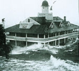
The hurricane produced a record-high wind gust of 135 mph (215 km/h) at Block Island
Block Island
Block Island is part of the U.S. state of Rhode Island and is located in the Atlantic Ocean approximately south of the coast of Rhode Island, east of Montauk Point on Long Island, and is separated from the Rhode Island mainland by Block Island Sound. The United States Census Bureau defines Block...
, while on mainland Rhode Island
Rhode Island
The state of Rhode Island and Providence Plantations, more commonly referred to as Rhode Island , is a state in the New England region of the United States. It is the smallest U.S. state by area...
, sustained winds peaked at 90 mph (145 km/h) in Warwick
Warwick, Rhode Island
Warwick is a city in Kent County, Rhode Island, United States. It is the second largest city in the state, with a population of 82,672 at the 2010 census. Its mayor has been Scott Avedisian since 2000...
with gusts to 105 mph (170 km/h). Upon making landfall around high tide, Carol produced a storm surge of up to 14.4 feet (4.4 m) in Narragansett Bay
Narragansett Bay
Narragansett Bay is a bay and estuary on the north side of Rhode Island Sound. Covering 147 mi2 , the Bay forms New England's largest estuary, which functions as an expansive natural harbor, and includes a small archipelago...
, surpassing that of the New England Hurricane of 1938
New England Hurricane of 1938
The New England Hurricane of 1938 was the first major hurricane to strike New England since 1869...
. The resulting storm surge flooded downtown Providence
Providence, Rhode Island
Providence is the capital and most populous city of Rhode Island and was one of the first cities established in the United States. Located in Providence County, it is the third largest city in the New England region...
with 12 feet (3.7 m) of water. Some entire coastal communities were nearly destroyed. The winds destroyed the roofs of hundreds of buildings, forcing many to evacuate to shelters during the passage of the storm. The powerful winds also downed thousands of trees and power lines, leaving 85% of the entire state without power. More than 5,000 buildings were destroyed across the state from the winds of the storm surge flooding.
Massachusetts
The Commonwealth of Massachusetts is a state in the New England region of the northeastern United States of America. It is bordered by Rhode Island and Connecticut to the south, New York to the west, and Vermont and New Hampshire to the north; at its east lies the Atlantic Ocean. As of the 2010...
, the hurricane produced winds between 80 to 110 mph (130 to 180 km/h) across much of the eastern part of the state, while near the coast strong storm surges were reported. The winds left much of the eastern portion of the state without power. In Boston, the spire of the historic Old North Church
Old North Church
Old North Church , at 193 Salem Street, in the North End of Boston, is the location from which the famous "One if by land, and two if by sea" signal is said to have been sent...
was blown down. Salt water, which moved inland as far as Route 6
U.S. Route 6
U.S. Route 6 , also called the Grand Army of the Republic Highway, a name that honors an American Civil War veterans association, is a main route of the U.S. Highway system, running east-northeast from Bishop, California to Provincetown, Massachusetts. Until 1964, it continued south from Bishop to...
, killed thousands of trees; for decades after the storm the forest of white trees mixed with new growth was visible along the length of Massachusetts Route 88 between Route 6 and the Horseneck Beach area in Westport, Massachusetts
Westport, Massachusetts
Westport is a town in Bristol County, Massachusetts, United States. The population was 15,532 at the 2010 census.The village of North Westport lies in the town.- History :...
.
Carol maintained its intensity is it moved inland, and produced winds of up to at 80 mph (130 km/h) in Augusta, Maine
Augusta, Maine
Augusta is the capital of the US state of Maine, county seat of Kennebec County, and center of population for Maine. The city's population was 19,136 at the 2010 census, making it the third-smallest state capital after Montpelier, Vermont and Pierre, South Dakota...
. Throughout the state, the winds downed hundreds of trees, some of which damaged houses, wrecked cars, destroyed one building, or fell onto power lines. In addition, one was injured by a falling tree limb. Downed power lines left several counties without power or telephone services. The winds flattened hundreds of acres of corn in North Livermore
Livermore, Maine
Livermore is a town in Androscoggin County, Maine, United States. The population was 2,106 at the 2000 census. It is included in both the Lewiston-Auburn, Maine Metropolitan Statistical Area and the Lewiston-Auburn, Maine Metropolitan New England City and Town Area. High schools students from...
, and throughout the state apples were torn off of trees. Damage to the apple crop amounted to $1.7 million (1954 USD, $12.7 million 2006 USD). While moving west of Maine, the hurricane dropped heavy rainfall, including a report of 2.15 inches (63 mm) in 12 hours. In Maine, the hurricane killed three people, injured at least 8, and caused damage totaling to $10 million (1954 USD, $74.9 million 2006 USD), the costliest natural disaster in the state's history. Carol lost this distinction 10 days later when Hurricane Edna
Hurricane Edna
Hurricane Edna was a deadly and destructive major hurricane that impacted the United States East Coast in September of the 1954 Atlantic hurricane season. It was one of two hurricanes to strike Massachusetts in that year, the other being Hurricane Carol...
caused $15 million (1954 USD, $112 million 2006 USD) in damage in the state.
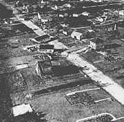
Strong winds from Hurricane Carol destroyed nearly 40% of the apple, corn, peach, and tomato crops from eastern Connecticut to Cape Cod
Cape Cod
Cape Cod, often referred to locally as simply the Cape, is a cape in the easternmost portion of the state of Massachusetts, in the Northeastern United States...
. The hurricane destroyed several thousand homes in New England, many of which were destroyed from the waters or the powerful winds. The hurricane also destroyed 3,500 cars and 3,000 boats. Hurricane Carol caused $460 million in damage (1954 USD, $3.45 billion 2006 USD) and 65 deaths in New England.
Aftermath
MaineMaine
Maine is a state in the New England region of the northeastern United States, bordered by the Atlantic Ocean to the east and south, New Hampshire to the west, and the Canadian provinces of Quebec to the northwest and New Brunswick to the northeast. Maine is both the northernmost and easternmost...
governor Burton M. Cross
Burton M. Cross
Burton Melvin Cross was a Maine Republican politician. Cross was Maine's 61st and 63rd Governor....
declared a state of emergency for the state. The Small Business Administration declared six counties in Maine as disaster areas.
As there was no provision at the time for name retirement, the name Carol was used again in the 1965 season
1965 Atlantic hurricane season
The 1965 Atlantic hurricane season officially began on June 1, 1965, and lasted until November 30, 1965. These dates conventionally delimit the period of each year when most tropical cyclones form in the Atlantic basin....
, and was planned for use during the 1969 hurricane season before it was replaced (the replacement name would itself be associated with one of the worst Atlantic hurricanes in history – Camille
Hurricane Camille
Hurricane Camille was the third and strongest tropical cyclone and second hurricane during the 1969 Atlantic hurricane season. The second of three catastrophic Category 5 hurricanes to make landfall in the United States during the 20th century , which it did near the mouth of the Mississippi River...
). Due to serious destruction during 1954, however, the name will never again be used for an Atlantic hurricane. Carol was the first Atlantic hurricane name in history to be retired.
See also
- List of Atlantic hurricanes
- List of North Carolina hurricanes