
.gif)
Hurricane Allison (1995)
Encyclopedia
Hurricane Allison was the first named storm
and first hurricane of the 1995 Atlantic hurricane season
. It was an early season hurricane that delivered heavy rains and caused minor damage, primarily across Cuba
, Florida
and Georgia
.
The storm developed on June 2, less than 48 hours after the official start of the hurricane season. It strengthened into a tropical storm early on June 3 and into a hurricane on June 4 in the Gulf of Mexico
. It would make landfall in the Big Bend
area of Florida
on June 5 before tracking northward as an extratropical system. One death was reported in Cuba
. Allison's early formation heralded the start of what would eventually become a very active 1995 hurricane season.
that moved across the eastern Caribbean Sea
in the last week of May. The wave gradually organized itself as it entered the western Caribbean Sea on June 1. The circulation continued to close up on June 2 and that evening it was declared Tropical Depression One while east of Honduras
.
The depression was in an unusually low-shear environment for early June as it began tracking northward, which allowed the system to strengthen into Tropical Storm Allison on the morning of June 3 as it tracked into the Yucatan Channel
. Despite the fact that westerly wind shear
began to increase, the warm water allowed Allison to gradually strengthen more that afternoon and evening. Late that evening, while between the Yucatan Peninsula
and Cuba
, Allison developed a circular central dense overcast and became a high-end tropical storm. As the storm emerged into the Gulf of Mexico
, the warm waters allowed Allison to strengthen further and it was upgraded to a hurricane on the morning of June 4 while travelling almost due north.
Allison remained somewhat disorganized, as no eye
was ever visible, even when Reconnaissance
flights confirmed that it was at hurricane intensity. The storm maintained itself as a minimal hurricane throughout the day on June 4 before it began to turn to the northeast, in response to southwesterly shear. Late that evening, the storm began to weaken, dropping back to tropical storm intensity as it approached the Florida
Big Bend
area. The intensity leveled off on June 5 until it made landfall that morning. Allison made its first landfall at about 10:00 am EDT (1400 UTC) near Alligator Point, Florida
as a high-end tropical storm with 70 mph (110 km/h) winds. It briefly re-emerged over Apalachee Bay
and made another landfall near St. Marks, Florida
about one hour later with 65 mph (100 km/h) winds. Operationally, Allison was considered a hurricane until it made landfall, and was considered the earliest hurricane landfall in the United States for a while.
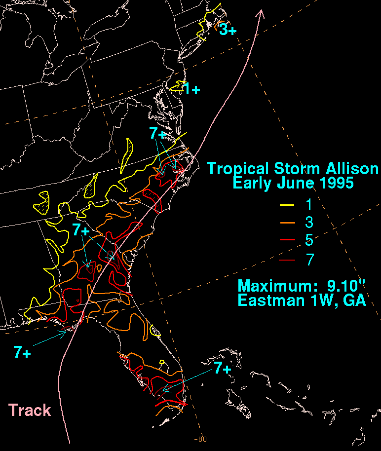
After making its final Florida landfall, Allison rapidly weakened. Tropical storm force winds continued over the eastern Florida Panhandle
until late that afternoon, as the storm moved northward into Georgia
. It weakened to a tropical depression on the evening of June 5 over southern Georgia. Early on June 6, Allison began to transition into an extratropical storm
as it interacted with a warm front
to the northeast while tracking across the Carolinas. The remnant low emerged into the Atlantic Ocean
off the coast of Cape Hatteras
that evening. It then raced across the western Atlantic, crossing the easternmost part of Nova Scotia
on June 8 and Newfoundland
on June 9. It continued northward across the Labrador Sea
, dissipating on June 11.
 Winds to tropical storm-force were reported throughout the western part of Cuba
, with a peak gust of 64 mph (102 km/h) in Havana
. Heavy rainfall of up to 18 inches (450 mm) was also reported in the area. 32 houses were damaged or destroyed due to flooding that resulted. One person was killed in western Cuba and three others were injured. The overall economic loss as a result of the storm was reported to have fairly minor.
In Florida
, Allison's winds knocked down power lines, leaving 48,000 residents without power or telephone services. Along the 150-mile (240 km) stretch of Florida's Big Bend
, 65 seaside homes were flooded and there was extensive beach erosion
as a result of the storm surge
. Three hotels and a restaurant were damaged. In Apalachicola
, three fishing boats were swamped; the storm closed a bridge linking Apalachicola with St. George Island. The highest storm surge in Florida was about 6 to 8 feet (1.8 to 2.5 m) in Wakulla
and Dixie
Counties, and 2 to 6 feet (0.6 to 1.8 m) to the east. A tornado
spawned by Allison touched down at Jacksonville Beach
, causing minor damage when it downed power lines and flipped over vehicles. Minor crop damage was also reported. There were no deaths reported as a result of Allison in Florida. Damage was estimated at $860,000 (1995 USD) in Florida, primarily as a result of the storm surge.
Most of the damage in Georgia
was as a result of several tornadoes related to Allison. The most significant of the tornadoes touched down in the town of St. Marys
. An elementary school
was destroyed and significant damage was also reported to several buildings at the Kings Bay Naval Submarine Base. Several other tornadoes also touched down but damage from them was minimal. Damage from the tornado was estimated at $800,000 (1995 USD).
Tropical cyclone
A tropical cyclone is a storm system characterized by a large low-pressure center and numerous thunderstorms that produce strong winds and heavy rain. Tropical cyclones strengthen when water evaporated from the ocean is released as the saturated air rises, resulting in condensation of water vapor...
and first hurricane of the 1995 Atlantic hurricane season
1995 Atlantic hurricane season
The 1995 Atlantic hurricane season was the third most active Atlantic hurricane season on record. It officially began on June 1, 1995, and lasted until November 30, 1995. These dates conventionally delimit the period of each year when most tropical cyclones form in the north Atlantic ocean...
. It was an early season hurricane that delivered heavy rains and caused minor damage, primarily across Cuba
Cuba
The Republic of Cuba is an island nation in the Caribbean. The nation of Cuba consists of the main island of Cuba, the Isla de la Juventud, and several archipelagos. Havana is the largest city in Cuba and the country's capital. Santiago de Cuba is the second largest city...
, Florida
Florida
Florida is a state in the southeastern United States, located on the nation's Atlantic and Gulf coasts. It is bordered to the west by the Gulf of Mexico, to the north by Alabama and Georgia and to the east by the Atlantic Ocean. With a population of 18,801,310 as measured by the 2010 census, it...
and Georgia
Georgia (U.S. state)
Georgia is a state located in the southeastern United States. It was established in 1732, the last of the original Thirteen Colonies. The state is named after King George II of Great Britain. Georgia was the fourth state to ratify the United States Constitution, on January 2, 1788...
.
The storm developed on June 2, less than 48 hours after the official start of the hurricane season. It strengthened into a tropical storm early on June 3 and into a hurricane on June 4 in the Gulf of Mexico
Gulf of Mexico
The Gulf of Mexico is a partially landlocked ocean basin largely surrounded by the North American continent and the island of Cuba. It is bounded on the northeast, north and northwest by the Gulf Coast of the United States, on the southwest and south by Mexico, and on the southeast by Cuba. In...
. It would make landfall in the Big Bend
Big Bend
-United States:* Big Bend , region of Texas** Big Bend National Park, in Texas* Big Bend, California, census-designated place* Big Bend, Butte County, California, unincorporated community* Big Bend, Placer County, California, unincorporated community...
area of Florida
Florida
Florida is a state in the southeastern United States, located on the nation's Atlantic and Gulf coasts. It is bordered to the west by the Gulf of Mexico, to the north by Alabama and Georgia and to the east by the Atlantic Ocean. With a population of 18,801,310 as measured by the 2010 census, it...
on June 5 before tracking northward as an extratropical system. One death was reported in Cuba
Cuba
The Republic of Cuba is an island nation in the Caribbean. The nation of Cuba consists of the main island of Cuba, the Isla de la Juventud, and several archipelagos. Havana is the largest city in Cuba and the country's capital. Santiago de Cuba is the second largest city...
. Allison's early formation heralded the start of what would eventually become a very active 1995 hurricane season.
Meteorological history
The origins of the system can be traced to a tropical waveTropical wave
Tropical waves, easterly waves, or tropical easterly waves, also known as African easterly waves in the Atlantic region, are a type of atmospheric trough, an elongated area of relatively low air pressure, oriented north to south, which move from east to west across the tropics causing areas of...
that moved across the eastern Caribbean Sea
Caribbean Sea
The Caribbean Sea is a sea of the Atlantic Ocean located in the tropics of the Western hemisphere. It is bounded by Mexico and Central America to the west and southwest, to the north by the Greater Antilles, and to the east by the Lesser Antilles....
in the last week of May. The wave gradually organized itself as it entered the western Caribbean Sea on June 1. The circulation continued to close up on June 2 and that evening it was declared Tropical Depression One while east of Honduras
Honduras
Honduras is a republic in Central America. It was previously known as Spanish Honduras to differentiate it from British Honduras, which became the modern-day state of Belize...
.
The depression was in an unusually low-shear environment for early June as it began tracking northward, which allowed the system to strengthen into Tropical Storm Allison on the morning of June 3 as it tracked into the Yucatan Channel
Yucatán Channel
The Yucatán Channel is a strait between Mexico and Cuba. It connects the Yucatán Basin of the Caribbean Sea with the Gulf of Mexico. The strait is across between Cape Catoche in Mexico and Cape San Antonio, Cuba and reaches a maximum depth of .-References:...
. Despite the fact that westerly wind shear
Wind shear
Wind shear, sometimes referred to as windshear or wind gradient, is a difference in wind speed and direction over a relatively short distance in the atmosphere...
began to increase, the warm water allowed Allison to gradually strengthen more that afternoon and evening. Late that evening, while between the Yucatan Peninsula
Yucatán Peninsula
The Yucatán Peninsula, in southeastern Mexico, separates the Caribbean Sea from the Gulf of Mexico, with the northern coastline on the Yucatán Channel...
and Cuba
Cuba
The Republic of Cuba is an island nation in the Caribbean. The nation of Cuba consists of the main island of Cuba, the Isla de la Juventud, and several archipelagos. Havana is the largest city in Cuba and the country's capital. Santiago de Cuba is the second largest city...
, Allison developed a circular central dense overcast and became a high-end tropical storm. As the storm emerged into the Gulf of Mexico
Gulf of Mexico
The Gulf of Mexico is a partially landlocked ocean basin largely surrounded by the North American continent and the island of Cuba. It is bounded on the northeast, north and northwest by the Gulf Coast of the United States, on the southwest and south by Mexico, and on the southeast by Cuba. In...
, the warm waters allowed Allison to strengthen further and it was upgraded to a hurricane on the morning of June 4 while travelling almost due north.
Allison remained somewhat disorganized, as no eye
Eye (cyclone)
The eye is a region of mostly calm weather found at the center of strong tropical cyclones. The eye of a storm is a roughly circular area and typically 30–65 km in diameter. It is surrounded by the eyewall, a ring of towering thunderstorms where the second most severe weather of a cyclone...
was ever visible, even when Reconnaissance
Reconnaissance
Reconnaissance is the military term for exploring beyond the area occupied by friendly forces to gain information about enemy forces or features of the environment....
flights confirmed that it was at hurricane intensity. The storm maintained itself as a minimal hurricane throughout the day on June 4 before it began to turn to the northeast, in response to southwesterly shear. Late that evening, the storm began to weaken, dropping back to tropical storm intensity as it approached the Florida
Florida
Florida is a state in the southeastern United States, located on the nation's Atlantic and Gulf coasts. It is bordered to the west by the Gulf of Mexico, to the north by Alabama and Georgia and to the east by the Atlantic Ocean. With a population of 18,801,310 as measured by the 2010 census, it...
Big Bend
Big Bend
-United States:* Big Bend , region of Texas** Big Bend National Park, in Texas* Big Bend, California, census-designated place* Big Bend, Butte County, California, unincorporated community* Big Bend, Placer County, California, unincorporated community...
area. The intensity leveled off on June 5 until it made landfall that morning. Allison made its first landfall at about 10:00 am EDT (1400 UTC) near Alligator Point, Florida
Alligator Point, Florida
Alligator Point is an unincorporated community in Franklin County, Florida, United States. It is located along US 98, south of Bald Point State Park. , on the Gulf of Mexico. Alligator Point is a small beach community made up of mostly beach homes and the...
as a high-end tropical storm with 70 mph (110 km/h) winds. It briefly re-emerged over Apalachee Bay
Apalachee Bay
Apalachee Bay is a bay in the northeastern Gulf of Mexico occupying an indentation of the Florida coast to the west of where the Florida peninsula joins the United States mainland. It is bordered by Taylor, Jefferson, Wakulla and Franklin counties. The Aucilla, Econfina, St. Marks and Ochlocknee...
and made another landfall near St. Marks, Florida
St. Marks, Florida
St. Marks is a city in Wakulla County, Florida, United States. It is part of the Tallahassee, Florida, Metropolitan Statistical Area. The population was 272 at the 2000 census. As of 2004, the population estimated by the U.S. Census Bureau is 299 .-Geography:...
about one hour later with 65 mph (100 km/h) winds. Operationally, Allison was considered a hurricane until it made landfall, and was considered the earliest hurricane landfall in the United States for a while.
After making its final Florida landfall, Allison rapidly weakened. Tropical storm force winds continued over the eastern Florida Panhandle
Florida Panhandle
The Florida Panhandle, an informal, unofficial term for the northwestern part of Florida, is a strip of land roughly 200 miles long and 50 to 100 miles wide , lying between Alabama on the north and the west, Georgia also on the north, and the Gulf of Mexico to the south. Its eastern boundary is...
until late that afternoon, as the storm moved northward into Georgia
Georgia (U.S. state)
Georgia is a state located in the southeastern United States. It was established in 1732, the last of the original Thirteen Colonies. The state is named after King George II of Great Britain. Georgia was the fourth state to ratify the United States Constitution, on January 2, 1788...
. It weakened to a tropical depression on the evening of June 5 over southern Georgia. Early on June 6, Allison began to transition into an extratropical storm
Extratropical cyclone
Extratropical cyclones, sometimes called mid-latitude cyclones or wave cyclones, are a group of cyclones defined as synoptic scale low pressure weather systems that occur in the middle latitudes of the Earth having neither tropical nor polar characteristics, and are connected with fronts and...
as it interacted with a warm front
Warm front
A warm front is a density discontinuity located at the leading edge of a homogeneous warm air mass, and is typically located on the equator-facing edge of an isotherm gradient...
to the northeast while tracking across the Carolinas. The remnant low emerged into the Atlantic Ocean
Atlantic Ocean
The Atlantic Ocean is the second-largest of the world's oceanic divisions. With a total area of about , it covers approximately 20% of the Earth's surface and about 26% of its water surface area...
off the coast of Cape Hatteras
Cape Hatteras
Cape Hatteras is a cape on the coast of North Carolina. It is the point that protrudes the farthest to the southeast along the northeast-to-southwest line of the Atlantic coast of North America...
that evening. It then raced across the western Atlantic, crossing the easternmost part of Nova Scotia
Nova Scotia
Nova Scotia is one of Canada's three Maritime provinces and is the most populous province in Atlantic Canada. The name of the province is Latin for "New Scotland," but "Nova Scotia" is the recognized, English-language name of the province. The provincial capital is Halifax. Nova Scotia is the...
on June 8 and Newfoundland
Newfoundland and Labrador
Newfoundland and Labrador is the easternmost province of Canada. Situated in the country's Atlantic region, it incorporates the island of Newfoundland and mainland Labrador with a combined area of . As of April 2011, the province's estimated population is 508,400...
on June 9. It continued northward across the Labrador Sea
Labrador Sea
The Labrador Sea is an arm of the North Atlantic Ocean between the Labrador Peninsula and Greenland. The sea is flanked by continental shelves to the southwest, northwest, and northeast. It connects to the north with Baffin Bay through the Davis Strait...
, dissipating on June 11.
Impact
Cuba
The Republic of Cuba is an island nation in the Caribbean. The nation of Cuba consists of the main island of Cuba, the Isla de la Juventud, and several archipelagos. Havana is the largest city in Cuba and the country's capital. Santiago de Cuba is the second largest city...
, with a peak gust of 64 mph (102 km/h) in Havana
Havana
Havana is the capital city, province, major port, and leading commercial centre of Cuba. The city proper has a population of 2.1 million inhabitants, and it spans a total of — making it the largest city in the Caribbean region, and the most populous...
. Heavy rainfall of up to 18 inches (450 mm) was also reported in the area. 32 houses were damaged or destroyed due to flooding that resulted. One person was killed in western Cuba and three others were injured. The overall economic loss as a result of the storm was reported to have fairly minor.
In Florida
Florida
Florida is a state in the southeastern United States, located on the nation's Atlantic and Gulf coasts. It is bordered to the west by the Gulf of Mexico, to the north by Alabama and Georgia and to the east by the Atlantic Ocean. With a population of 18,801,310 as measured by the 2010 census, it...
, Allison's winds knocked down power lines, leaving 48,000 residents without power or telephone services. Along the 150-mile (240 km) stretch of Florida's Big Bend
Big Bend
-United States:* Big Bend , region of Texas** Big Bend National Park, in Texas* Big Bend, California, census-designated place* Big Bend, Butte County, California, unincorporated community* Big Bend, Placer County, California, unincorporated community...
, 65 seaside homes were flooded and there was extensive beach erosion
Erosion
Erosion is when materials are removed from the surface and changed into something else. It only works by hydraulic actions and transport of solids in the natural environment, and leads to the deposition of these materials elsewhere...
as a result of the storm surge
Storm surge
A storm surge is an offshore rise of water associated with a low pressure weather system, typically tropical cyclones and strong extratropical cyclones. Storm surges are caused primarily by high winds pushing on the ocean's surface. The wind causes the water to pile up higher than the ordinary sea...
. Three hotels and a restaurant were damaged. In Apalachicola
Apalachicola, Florida
Apalachicola is a city in Franklin County, Florida, on US 98 about southwest of Tallahassee. The population was 2,334 at the 2000 census. The 2005 census estimated the city's population at 2,340...
, three fishing boats were swamped; the storm closed a bridge linking Apalachicola with St. George Island. The highest storm surge in Florida was about 6 to 8 feet (1.8 to 2.5 m) in Wakulla
Wakulla County, Florida
Wakulla County is a county located in the U.S. state of Florida. As of 2000, the population was 22,863. The U.S. Census Bureau 2005 estimate for the county was 28,212 people...
and Dixie
Dixie County, Florida
Dixie County is a county located in the U.S. state of Florida. As of 2000, the population was 13,827. The U.S. Census Bureau 2005 estimate for the county is 14,647 . Its county seat is Cross City, Florida.- History :...
Counties, and 2 to 6 feet (0.6 to 1.8 m) to the east. A tornado
Tornado
A tornado is a violent, dangerous, rotating column of air that is in contact with both the surface of the earth and a cumulonimbus cloud or, in rare cases, the base of a cumulus cloud. They are often referred to as a twister or a cyclone, although the word cyclone is used in meteorology in a wider...
spawned by Allison touched down at Jacksonville Beach
Jacksonville Beach, Florida
Jacksonville Beach is a city on the Atlantic coast of Duval County, Florida, east of Jacksonville. It is part of the Jacksonville Beaches community, together with Mayport, Atlantic Beach, Neptune Beach, and Ponte Vedra Beach...
, causing minor damage when it downed power lines and flipped over vehicles. Minor crop damage was also reported. There were no deaths reported as a result of Allison in Florida. Damage was estimated at $860,000 (1995 USD) in Florida, primarily as a result of the storm surge.
Most of the damage in Georgia
Georgia (U.S. state)
Georgia is a state located in the southeastern United States. It was established in 1732, the last of the original Thirteen Colonies. The state is named after King George II of Great Britain. Georgia was the fourth state to ratify the United States Constitution, on January 2, 1788...
was as a result of several tornadoes related to Allison. The most significant of the tornadoes touched down in the town of St. Marys
St. Marys, Georgia
-See also:*Cumberland Island*St. Marys Historic District*St. Marys Railroad-External links:***...
. An elementary school
Elementary school
An elementary school or primary school is an institution where children receive the first stage of compulsory education known as elementary or primary education. Elementary school is the preferred term in some countries, particularly those in North America, where the terms grade school and grammar...
was destroyed and significant damage was also reported to several buildings at the Kings Bay Naval Submarine Base. Several other tornadoes also touched down but damage from them was minimal. Damage from the tornado was estimated at $800,000 (1995 USD).
See also
- Timeline of the 1995 Atlantic hurricane seasonTimeline of the 1995 Atlantic hurricane seasonThis timeline documents all the storm formations, strengthening, weakening, landfalls, extratropical transitions, as well as dissipation during the 1995 Atlantic hurricane season. The season officially began on June 1, 1995, and ended on November 30, and no storms formed off-season...
- List of North Carolina hurricanes (1980–present)