

Outer Banks
Encyclopedia
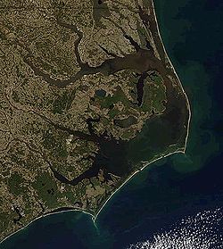
Barrier island
Barrier islands, a coastal landform and a type of barrier system, are relatively narrow strips of sand that parallel the mainland coast. They usually occur in chains, consisting of anything from a few islands to more than a dozen...
s off the coast of North Carolina
North Carolina
North Carolina is a state located in the southeastern United States. The state borders South Carolina and Georgia to the south, Tennessee to the west and Virginia to the north. North Carolina contains 100 counties. Its capital is Raleigh, and its largest city is Charlotte...
, beginning in the southeastern corner of Virginia Beach on the east coast of the United States
United States
The United States of America is a federal constitutional republic comprising fifty states and a federal district...
.
They cover approximately half the northern North Carolina coastline, separating the Currituck Sound
Currituck Sound
Currituck Sound is a protected inlet of the Atlantic Ocean in northeastern part of North Carolina. Thirty miles N-S and 3–8 miles wide, this shallow, island-filled sound is separated from the ocean by Bodie Island, part of the Outer Banks...
, Albemarle Sound
Albemarle Sound
Albemarle Sound is a large estuary on the coast of North Carolina in the United States located at the confluence of a group of rivers, including the Chowan and Roanoke. It is separated from the Atlantic Ocean by the Outer Banks, a long barrier peninsula upon which the town of Kitty Hawk is located,...
, and Pamlico Sound
Pamlico Sound
Pamlico Sound in North Carolina, is the largest lagoon along the U.S. East Coast, being long and 24 to 48 km wide. It is a body of water separated from the Atlantic Ocean by the Outer Banks, a row of low, sandy barrier islands, including Cape Hatteras. The Neuse and Pamlico rivers flow in...
from the Atlantic Ocean
Atlantic Ocean
The Atlantic Ocean is the second-largest of the world's oceanic divisions. With a total area of about , it covers approximately 20% of the Earth's surface and about 26% of its water surface area...
.
The Outer Banks is a major tourist destination and is known for its temperate climate and wide expanse of open beach
Beach
A beach is a geological landform along the shoreline of an ocean, sea, lake or river. It usually consists of loose particles which are often composed of rock, such as sand, gravel, shingle, pebbles or cobblestones...
front. The Cape Hatteras National Seashore
Cape Hatteras National Seashore
Cape Hatteras National Seashore preserves the portion of the Outer Banks of North Carolina from Bodie Island to Ocracoke Island, stretching over . Included within this section of barrier islands along N.C...
has four campgrounds where visitors may camp.
The Wright brothers
Wright brothers
The Wright brothers, Orville and Wilbur , were two Americans credited with inventing and building the world's first successful airplane and making the first controlled, powered and sustained heavier-than-air human flight, on December 17, 1903...
' first flight in a powered, heavier-than-air vehicle took place on the Outer Banks on December 17, 1903, at Kill Devil Hills
Kill Devil Hills, North Carolina
Kill Devil Hills is a town in Dare County, North Carolina, USA. The population was 5,897 at the 2000 census.Nearby Kitty Hawk is frequently cited as the location of the Wright brothers' first controlled, powered airplane flights on December 17, 1903...
near the seafront town of Kitty Hawk
Kitty Hawk, North Carolina
Kitty Hawk is a town in Dare County, North Carolina, United States. The population was 3,000 at the 2000 census. It was established in the early 18th century as Chickahawk....
. The Wright Brothers National Monument commemorates the historic flights, and First Flight Airport
First Flight Airport
First Flight Airport is a general aviation airport located in Kill Devil Hills, a town in Dare County, North Carolina, United States. The airport itself is famous for being the site of hundreds of pre-flight gliding experiments carried out by the Wright brothers...
is a small, general-aviation airfield located there.
The English Roanoke Colony
Roanoke Colony
The Roanoke Colony on Roanoke Island in Dare County, present-day North Carolina, United States was a late 16th-century attempt to establish a permanent English settlement in what later became the Virginia Colony. The enterprise was financed and organized by Sir Walter Raleigh and carried out by...
—where the first person of English descent, Virginia Dare
Virginia Dare
Virginia Dare was the first child born in the Americas to English parents, Eleanor and Ananias Dare. She was born into the short-lived Roanoke Colony in what is now North Carolina, USA. What became of Virginia and the other colonists remains a mystery...
, was born on American soil—vanished from Roanoke Island
Roanoke Island
Roanoke Island is an island in Dare County near the coast of North Carolina, United States. It was named after the historical Roanoke Carolina Algonquian people who inhabited the area in the 16th century at the time of English exploration....
in 1587. The Lost Colony
Lost Colony (play)
The Lost Colony is a historical play by Pulitzer Prize-winning playwright Paul Green about Roanoke, the first English colony in North America. The play is based on the historical accounts of Sir Walter Raleigh's failed attempts to establish a permanent settlement in the 1580s in part of what was...
, written and performed to commemorate the original colonists, is the longest running outdoor drama in the United States and its theater acts as a cultural focal point for much of the Outer Banks.
The treacherous seas off the Outer Banks and the large number of shipwreck
Shipwreck
A shipwreck is what remains of a ship that has wrecked, either sunk or beached. Whatever the cause, a sunken ship or a wrecked ship is a physical example of the event: this explains why the two concepts are often overlapping in English....
s that have occurred there have given these seas the nickname Graveyard of the Atlantic
Graveyard of the Atlantic
Graveyard of the Atlantic is a nickname of two locations known for numerous shipwrecks: the treacherous waters in the Atlantic Ocean along the Outer Banks of North Carolina and the Virginia coastline south of the entrance to the Chesapeake Bay at Cape Henry; and around Sable Island, off the coast...
. The Graveyard of the Atlantic Museum is located in Hatteras Village near the United States Coast Guard
United States Coast Guard
The United States Coast Guard is a branch of the United States Armed Forces and one of the seven U.S. uniformed services. The Coast Guard is a maritime, military, multi-mission service unique among the military branches for having a maritime law enforcement mission and a federal regulatory agency...
facility and Hatteras ferry.

Geography
The Outer Banks is a series of islands: from north to south — Bodie IslandBodie Island
Bodie Island is a long, narrow barrier peninsula that forms the northernmost portion of the Outer Banks of North Carolina. The land that is most commonly referred to as Bodie Island was at one time a true island, however the inlet separating it from the Currituck Banks peninsula in the north closed...
, Roanoke Island
Roanoke Island
Roanoke Island is an island in Dare County near the coast of North Carolina, United States. It was named after the historical Roanoke Carolina Algonquian people who inhabited the area in the 16th century at the time of English exploration....
, Hatteras Island
Hatteras Island
Hatteras Island is a barrier island located off the North Carolina coast. Dividing the Atlantic Ocean and the Pamlico Sound, it runs parallel to the coast, forming a bend at Cape Hatteras. It is part of North Carolina's Outer Banks and includes the towns of Rodanthe, Waves, Salvo, Avon, Buxton,...
, and Ocracoke Island. The Outer Banks is considered to be the areas of coastal Currituck County
Currituck County, North Carolina
-National protected areas:*Currituck National Wildlife Refuge*Mackay Island National Wildlife Refuge -Demographics:As of the census of 2010, there were 23,547 people, 6,902 households, and 5,204 families residing in the county. The population density was 70 people per square mile . There were...
, Dare County
Dare County, North Carolina
-National protected areas:* Alligator River National Wildlife Refuge * Cape Hatteras National Seashore * Fort Raleigh National Historic Site* Pea Island National Wildlife Refuge* Wright Brothers National Memorial-Demographics:...
, and Hyde County
Hyde County, North Carolina
-National protected areas:* Alligator River National Wildlife Refuge * Cape Hatteras National Seashore * Mattamuskeet National Wildlife Refuge* Pocosin Lakes National Wildlife Refuge * Swanquarter National Wildlife Refuge-Demographics:...
. Some consider the Outer Banks to stretch as far south as Cape Lookout
Cape Lookout
Cape Lookout can refer to:*Cape Lookout , in the United States*Cape Lookout , in the United States*Cape Lookout...
including portions of Carteret County
Carteret County, North Carolina
Carteret County is a county located in the U.S. state of North Carolina. As of 2010, the population was 66,469. Its county seat is Beaufort. Most of the county is part of the Crystal Coast....
and as far north as Sandbridge
Sandbridge, Virginia Beach, Virginia
thumb|250px|A view of a Sandbridge beach from a pierSandbridge, in the U.S. state of Virginia, is a coastal community of Virginia Beach, located along the coastline at the northern end of the Outer Banks. The Atlantic Ocean is to the east, the Back Bay of the Currituck Sound is to the west, and...
in Virginia Beach. Areas south of Cape Lookout in Carteret County are considered the Crystal Coast
Crystal Coast
The Crystal Coast is an 85-mile stretch of coastline in North Carolina that extends from the Cape Lookout National Seashore, which includes 56 miles of protected beaches, westward to the New River. It is also known as the Southern Outer Banks and is a popular area with tourists and second-home...
, which for tourism purposes has been coined the "Southern Outer Banks". The northern part of the Outer Banks, from Oregon Inlet
Oregon Inlet
Oregon Inlet is an inlet along North Carolina's Outer Banks. It joins the Pamlico Sound with the Atlantic Ocean and separates Bodie Island from Pea Island, which are connected by a 2.5 mile bridge that spans the inlet...
northward, is actually a part of the North America
North America
North America is a continent wholly within the Northern Hemisphere and almost wholly within the Western Hemisphere. It is also considered a northern subcontinent of the Americas...
n mainland, since the northern inlets of Bodie Island and Currituck Banks no longer exist. It is separated by the Currituck Sound
Currituck Sound
Currituck Sound is a protected inlet of the Atlantic Ocean in northeastern part of North Carolina. Thirty miles N-S and 3–8 miles wide, this shallow, island-filled sound is separated from the ocean by Bodie Island, part of the Outer Banks...
and the Intracoastal Waterway
Intracoastal Waterway
The Intracoastal Waterway is a 3,000-mile waterway along the Atlantic and Gulf coasts of the United States. Some lengths consist of natural inlets, salt-water rivers, bays, and sounds; others are artificial canals...
, which passes through the Great Dismal Swamp
Great Dismal Swamp
The Great Dismal Swamp is a marshy area on the Coastal Plain Region of southeastern Virginia and northeastern North Carolina between Norfolk, Virginia, and Elizabeth City, North Carolina in the United States. It is located in parts of southern Chesapeake and Suffolk in Virginia, as well as northern...
occupying much of the mainland west of the Outer Banks. Road access to the northern Outer Banks is cut off between Sandbridge
Sandbridge, Virginia Beach, Virginia
thumb|250px|A view of a Sandbridge beach from a pierSandbridge, in the U.S. state of Virginia, is a coastal community of Virginia Beach, located along the coastline at the northern end of the Outer Banks. The Atlantic Ocean is to the east, the Back Bay of the Currituck Sound is to the west, and...
and Corolla, North Carolina
Corolla, North Carolina
Corolla is an unincorporated community located in Poplar Branch township, Currituck County, North Carolina along the northern Outer Banks. It has a permanent population of approximately 500 people; during the summer vacation season, the population surges into the thousands...
, with communities such as Carova Beach
Carova Beach, North Carolina
Carova Beach or Carova is an unincorporated community in Currituck County in the extreme northeast corner of North Carolina, USA. The community, which is found on Currituck Banks, north of Bodie Island, can only be accessed by boat or by four-wheel drive vehicle since there are no paved roads...
accessible only by four-wheel drive
Four-wheel drive
Four-wheel drive, 4WD, or 4×4 is a four-wheeled vehicle with a drivetrain that allows all four wheels to receive torque from the engine simultaneously...
vehicles. North Carolina State Highway 12
North Carolina State Highway 12
NC 12 is a North Carolina state highway that traverses the northeastern shoreline of North Carolina, linking the islands of the Outer Banks. It is a popular route for visitors touring the Outer Banks...
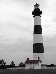
links most of the popular Outer Banks communities. The easternmost point is Cape Point at Cape Hatteras
Cape Hatteras
Cape Hatteras is a cape on the coast of North Carolina. It is the point that protrudes the farthest to the southeast along the northeast-to-southwest line of the Atlantic coast of North America...
on Hatteras Island, site of the Cape Hatteras Lighthouse.
The Outer Banks is not anchored to offshore coral reef
Coral reef
Coral reefs are underwater structures made from calcium carbonate secreted by corals. Coral reefs are colonies of tiny living animals found in marine waters that contain few nutrients. Most coral reefs are built from stony corals, which in turn consist of polyps that cluster in groups. The polyps...
s like some other barrier islands and as a consequence often suffers significant beach erosion
Erosion
Erosion is when materials are removed from the surface and changed into something else. It only works by hydraulic actions and transport of solids in the natural environment, and leads to the deposition of these materials elsewhere...
during major storms. In fact, its location jutting out into the Atlantic makes it the most hurricane-prone area north of Florida
Florida
Florida is a state in the southeastern United States, located on the nation's Atlantic and Gulf coasts. It is bordered to the west by the Gulf of Mexico, to the north by Alabama and Georgia and to the east by the Atlantic Ocean. With a population of 18,801,310 as measured by the 2010 census, it...
, for both landfalling storms and brushing storms offshore. Hatteras Island was cut in half on September 18, 2003, when Hurricane Isabel
Hurricane Isabel
Hurricane Isabel was the costliest and deadliest hurricane in the 2003 Atlantic hurricane season. The ninth named storm, fifth hurricane, and second major hurricane of the season, Isabel formed near the Cape Verde Islands from a tropical wave on September 6 in the tropical Atlantic Ocean...
washed a 2,000 foot (600 m) wide and 15 foot (5 m) deep channel called Isabel Inlet
Isabel Inlet
Isabel Inlet was an informally named inlet along the Outer Banks of North Carolina. It was created by Hurricane Isabel when it swept ashore on September 18, 2003....
through the community of Hatteras Village on the southern end of the island. The tear was subsequently repaired and restored by sand dredging by the Army Corps of Engineers. It was cut off once again in 2011 by Hurricane Irene
Hurricane Irene (2011)
Hurricane Irene was a large and powerful Atlantic hurricane that left extensive flood and wind damage along its path through the Caribbean, the United States East Coast and as far north as Atlantic Canada in 2011...
. Access to the island was largely limited to boat access only from August to late October until another temporary bridge could be built.
Vegetation
The vegetation of the Outer Banks is varied. In the northeast part of the Outer Banks from Virginia Beach southward past the North CarolinaNorth Carolina
North Carolina is a state located in the southeastern United States. The state borders South Carolina and Georgia to the south, Tennessee to the west and Virginia to the north. North Carolina contains 100 counties. Its capital is Raleigh, and its largest city is Charlotte...
border to Oregon Inlet
Oregon Inlet
Oregon Inlet is an inlet along North Carolina's Outer Banks. It joins the Pamlico Sound with the Atlantic Ocean and separates Bodie Island from Pea Island, which are connected by a 2.5 mile bridge that spans the inlet...
, the main type of vegetation are sea grasses, beach grasses and other beach plants including Opuntia humifusa on the Atlantic side and Wax Myrtles, bays, and grasses on the Sound side with areas of pine and Spanish Moss
Spanish Moss
Spanish moss is a flowering plant that grows upon larger trees, commonly the Southern Live Oak or Bald Cypress in the southeastern United States....
-covered Live Oaks
Live oak
Live oak , also known as the southern live oak, is a normally evergreen oak tree native to the southeastern United States...
. Yucca aloifolia
Yucca
Yucca is a genus of perennial shrubs and trees in the family Asparagaceae, subfamily Agavoideae. Its 40-50 species are notable for their rosettes of evergreen, tough, sword-shaped leaves and large terminal panicles of white or whitish flowers. They are native to the hot and dry parts of North...
can be found growing wild here in the northern parts of its range on the beach. Cabbage palmetto was once indigenous to the entire Outer Banks. Although its modern day natural northern range is only in the very southern Outer Banks, it is still successfully planted and grown anywhere on the Outer Banks.
From Cape Hatteras National Seashore
Cape Hatteras National Seashore
Cape Hatteras National Seashore preserves the portion of the Outer Banks of North Carolina from Bodie Island to Ocracoke Island, stretching over . Included within this section of barrier islands along N.C...
southward, the vegetation includes that of the northeastern Outer Banks. Cabbage palmetto, Sabal minor on the beach, and Yucca aloifolia which can be found in the north, although they are native and more commonly found in the southern part of the Outer Banks. Pindo palms and Windmill Palms are also planted widely throughout the Outer Banks although they are not indigenous to the area.
A wide variety of native plants can be found at the Elizabethan Gardens in Manteo
Manteo, North Carolina
Manteo is a town in Dare County, North Carolina, United States, located on Roanoke Island. The population was 1,052 at the 2000 census. It is the county seat of Dare County.-Geography:...
on Roanoke Island
Roanoke Island
Roanoke Island is an island in Dare County near the coast of North Carolina, United States. It was named after the historical Roanoke Carolina Algonquian people who inhabited the area in the 16th century at the time of English exploration....
. The gardens are open year round, 7 days a week.
Weather
The Outer Banks has unusual weather patterns due to its unique geographical location. As the islands are jutted out from the eastern seaboard into the Atlantic Gulf stream, the Outer Banks has a predisposition to be affected by hurricanes, Nor'easters (usually in the form of rain, and rarely snow or mixed precipitation), and other ocean driven storms.The Winter is typically milder than inland areas, averaging lows in the upper 30's and highs in the lower 50's, and is more frequently overcast than in the summer. However, the exposure of the Outer Banks makes it prone to higher winds, often causing wind chills to make the apparent temperature as cold as the inland areas. The Summer months average lows from the mid 70's to highs near 90, depending on the time of the summer. Spring and Fall are typically milder seasons. Fall and Winter are usually warmer than areas inland, while Spring and Summer are often slightly cooler due to the moderating affects of being surrounded by water.
Although snow is possible, averaging from 3 inches in the north to less than 1/2 inch per year in the south, there are many times when years pass between snowfalls. On very rare occasions, a nor'easter will pass far enough out to sea that the colder temperatures will be pulled further to the east, facilitating potentially significant amounts of snow. The majority of nor'easters are "born" off the coasts of the Outer Banks.
Culture
Brogue
A brogue is a strong accent, notably in Irish dialects of English. For example, in the folksong "Finnegan's Wake", the character of the song, Tim Finnegan, was said to have a "beautiful brogue so rich and sweet"....
, which sounds more like an English accent than it does an American accent. Many "bankers" have often been mistaken for being from England or Ireland when traveling to areas outside of the Outer Banks. The brogue is most distinctive the further south one travels on the Outer Banks, with it being the thickest on Ocracoke Island and Harkers Island. Locally, the accent is called "Hoi Toider", in that the term "High tider
High tider
"High Tider" or sometimes "Hoi Toider" is a nickname for a native of the rural eastern coast region of the U.S. state of North Carolina, specifically from several small townships such as Atlantic, Smyrna, Sea Level, and Harkers Island in eastern Carteret County, and from Ocracoke...
" is pronounced with a distinctive "oy" in the hard "i".
The islands are home to herds of feral horses, sometimes called "banker ponies
Banker Horse
The Banker horse is a breed of feral horse living on the islands of North Carolina's Outer Banks. It is small, hardy, and has a docile temperament...
," which according to local legend are descended from Spanish Mustangs
Mustang (horse)
A Mustang is a free-roaming horse of the North American west that first descended from horses brought to the Americas by the Spanish. Mustangs are often referred to as wild horses, but there is intense debate over terminology...
washed ashore centuries ago in shipwrecks. Colonies exist near Corolla and on Ocracoke Island.
Ocracoke
Ocracoke, North Carolina
Ocracoke is a census-designated place and unincorporated town located at the southern end of Ocracoke Island, located entirely within Hyde County, North Carolina. The population was 769 as of the 2000 census...
was the home base of pirate Edward Teach
Blackbeard
Edward Teach , better known as Blackbeard, was a notorious English pirate who operated around the West Indies and the eastern coast of the American colonies....
, better known as Blackbeard
Blackbeard
Edward Teach , better known as Blackbeard, was a notorious English pirate who operated around the West Indies and the eastern coast of the American colonies....
. It is also where the famed pirate was killed.
The Outer Banks is home to "Yaupon Holly" (Ilex vomitoria), the roasted leaves of which were brewed into a high caffeine beverage called black drink
Black drink
Black drink was the name given by colonists to a ritual beverage called Asi, brewed by Native Americans in the Southeastern United States...
by the Native Americans
Native Americans in the United States
Native Americans in the United States are the indigenous peoples in North America within the boundaries of the present-day continental United States, parts of Alaska, and the island state of Hawaii. They are composed of numerous, distinct tribes, states, and ethnic groups, many of which survive as...
. The Outer Banks may be one of the few places where it is still consumed.
Currituck Banks peninsula
- SandbridgeSandbridge, Virginia Beach, Virginiathumb|250px|A view of a Sandbridge beach from a pierSandbridge, in the U.S. state of Virginia, is a coastal community of Virginia Beach, located along the coastline at the northern end of the Outer Banks. The Atlantic Ocean is to the east, the Back Bay of the Currituck Sound is to the west, and...
- Carova BeachCarova Beach, North CarolinaCarova Beach or Carova is an unincorporated community in Currituck County in the extreme northeast corner of North Carolina, USA. The community, which is found on Currituck Banks, north of Bodie Island, can only be accessed by boat or by four-wheel drive vehicle since there are no paved roads...
- CorollaCorolla, North CarolinaCorolla is an unincorporated community located in Poplar Branch township, Currituck County, North Carolina along the northern Outer Banks. It has a permanent population of approximately 500 people; during the summer vacation season, the population surges into the thousands...
Bodie Island
- Duck
- Southern ShoresSouthern Shores, North CarolinaSouthern Shores is a town in Dare County, North Carolina, United States. The population was 2,714 at the 2010 census.-Geography:Southern Shores is located at ....
- Kitty HawkKitty Hawk, North CarolinaKitty Hawk is a town in Dare County, North Carolina, United States. The population was 3,000 at the 2000 census. It was established in the early 18th century as Chickahawk....
- Kill Devil HillsKill Devil Hills, North CarolinaKill Devil Hills is a town in Dare County, North Carolina, USA. The population was 5,897 at the 2000 census.Nearby Kitty Hawk is frequently cited as the location of the Wright brothers' first controlled, powered airplane flights on December 17, 1903...
- Nags HeadNags Head, North CarolinaNags Head is a town in Dare County, North Carolina, United States. The population was 2,700 at the 2000 census.-History:Early maps of the area show Nags Head as a promontory of land characterized by high sand dunes visible from miles at sea...
Hatteras Island
- RodantheRodanthe, North CarolinaRodanthe is an unincorporated community located in Dare County, North Carolina, on Hatteras Island, part of North Carolina's Outer Banks. Rodanthe, along with Waves and Salvo, are part of the settlement of Chicamacomico...
- WavesWaves, North CarolinaWaves is an unincorporated community in Dare County, North Carolina, USA. It is on Hatteras Island, part of North Carolina's Outer Banks. Waves, along with Rodanthe and Salvo, are part of the settlement of Chicamacomico....
- SalvoSalvo, North CarolinaSalvo is an unincorporated community located in Dare County, North Carolina, on Hatteras Island, part of North Carolina's Outer Banks. Originally part of the settlement of Chicamacomico, Salvo was originally known as Clarks or Clarksville.The name "Salvo" allegedly stems from the American Civil...
- AvonAvon, North CarolinaAvon is a a census-designated place in Dare County in the State of North Carolina in the United States of America. It is located at latitude 35°21'7" North, longitude 75°30'39" West. The village is south of Salvo and north of Buxton on Hatteras Island...
- BuxtonBuxton, North CarolinaBuxton is an unincorporated community of nearly 1,500 people on Hatteras Island near Cape Hatteras. It is located in Dare County in the U.S. state of North Carolina. North Carolina Highway 12 links the community to other Outer Banks communities such as Avon, Frisco, and Hatteras...
- FriscoFrisco, North CarolinaFrisco is a small unincorporated community on the barrier island of Hatteras Island, between the villages of Buxton and Hatteras. It is located in Dare County, North Carolina, USA, and was previously named Trent, or Trent Woods, but received a new name with the coming of the post office in 1898...
- HatterasHatteras, North CarolinaHatteras is an unincorporated community in Dare County, North Carolina, United States, on the Outer Banks island of Hatteras. North Carolina Highway 12 passes through the community linking it to Frisco and Ocracoke . It is south of the famous Cape Hatteras and the Cape Hatteras Lighthouse in Buxton...
Cape Lookout National Seashore
- Portsmouth Island (uninhabited)
- Core BanksCore Banks, North CarolinaThe Core Banks are barrier islands in North Carolina, part of the Cape Lookout National Seashore. They extend from Ocracoke Inlet to Cape Lookout, and consist of two low relief narrow islands, North Core Banks and South Core Banks, and, since September 2011, two smaller islands. New Drum Inlet,...
(uninhabited) - Shackleford BanksShackleford BanksShackleford Banks is a barrier island system on the coast of Carteret County, North Carolina. It contains a herd of feral horses, scallop, crabs and various sea animals, including summer nesting by loggerhead turtles...
(uninhabited)
Parks
- Back Bay National Wildlife RefugeBack Bay National Wildlife RefugeBack Bay National Wildlife Refuge in southeastern Virginia is located in the independent city of Virginia Beach. Established in 1938 in isolated portion of Princess Anne County, it is managed by the U.S. Fish & Wildlife Service....
- Cape Hatteras National SeashoreCape Hatteras National SeashoreCape Hatteras National Seashore preserves the portion of the Outer Banks of North Carolina from Bodie Island to Ocracoke Island, stretching over . Included within this section of barrier islands along N.C...
- Cape Lookout National SeashoreCape Lookout National SeashoreCape Lookout National Seashore preserves a 56-mile long section of the Southern Outer Banks, or Crystal Coast, of North Carolina, USA, running from Ocracoke Inlet on the northeast to Beaufort Inlet on the southeast. Three undeveloped barrier islands make up the seashore - North Core Banks, South...
- Currituck Heritage ParkCorolla, North CarolinaCorolla is an unincorporated community located in Poplar Branch township, Currituck County, North Carolina along the northern Outer Banks. It has a permanent population of approximately 500 people; during the summer vacation season, the population surges into the thousands...
- False Cape State ParkFalse Cape State ParkFalse Cape State Park is a state park in the independent city of Virginia Beach, Virginia. It is a mile-wide barrier spit between Back Bay and the Atlantic Ocean. The park adjoins the state border with North Carolina and lies shortly north of Mackay Island National Wildlife Refuge...
- Fort Macon State ParkFort Macon State ParkFort Macon State Park is a North Carolina state park in Carteret County, North Carolina, in the United States. Located on Bogue Banks near Atlantic Beach, the park opened in 1936...
- Fort Raleigh National Historic Site
- Jockey's Ridge State ParkJockey's Ridge State ParkJockey's Ridge State Park is a North Carolina state park in Dare County, North Carolina in the United States. Located in Nags Head, North Carolina, it covers 426 acres and includes the tallest active sand dune system in the eastern United States. It is the most visited park within the NC park...
- Pea Island National Wildlife RefugePea Island National Wildlife RefugePea Island National Wildlife Refuge is a National Wildlife Refuge located on the north end of North Carolina's Hatteras Island, a coastal barrier island and part of a chain of islands known as the Outer Banks, adjacent to Cape Hatteras National Seashore...
- Wright Brothers National MemorialWright Brothers National MemorialWright Brothers National Memorial, located in Kill Devil Hills, North Carolina, commemorates the first successful, sustained, powered flights in a heavier-than-air machine. From 1900 to 1903, Wilbur and Orville Wright came here from Dayton, Ohio, based on information from the U.S. Weather Bureau...
See also

- North Carolina Highway 12
- Inner BanksInner BanksThe Inner Banks is a term used by some to describe the inland coastal region of eastern North Carolina, an area on the East Coast of the United States that is 22,227 square-miles by its broadest definition...
- Crystal CoastCrystal CoastThe Crystal Coast is an 85-mile stretch of coastline in North Carolina that extends from the Cape Lookout National Seashore, which includes 56 miles of protected beaches, westward to the New River. It is also known as the Southern Outer Banks and is a popular area with tourists and second-home...
(Southern Outer Banks) - Outer Banks DaredevilsOuter Banks DaredevilsThe Outer Banks Daredevils are an amateur baseball team playing in the Coastal Plain League, a collegiate summer baseball league. The team plays its home games at the First Flight Baseball Complex in Kill Devil Hills, North Carolina. The Daredevils were one of the original teams in the Coastal...