
.gif)
Tropical Storm Alberto (2006)
Encyclopedia
Tropical Storm Alberto was the first tropical storm
of the 2006 Atlantic hurricane season
. Forming on June 10 in the northwestern Caribbean, the storm moved generally to the north, reaching a maximum intensity of 70 mph (110 km/h) before weakening and moving ashore in the Big Bend
area of Florida
on June 13. Alberto then moved through eastern Georgia
, North Carolina
, and Virginia
as a tropical depression before becoming extratropical on June 14.
Across the Western Caribbean, the storm produced heavy rainfall, causing some minor damage. In Florida, a moderate storm tide
caused coastal damage and flooding, while Alberto's outer rainbands produced several tornadoes. The storm was indirectly responsible for two drownings off the coast of Tampa Bay
. In North Carolina
, heavy rainfall caused locally severe flooding, and one child drowned in a flooded storm drain near Raleigh
. The remnants of Alberto produced strong winds and left four people missing in Atlantic Canada
. Overall, damage was minor along Alberto's path.
persisted across Central America and the western Caribbean in association with a broad, nearly stationary trough
of low pressure
. Thunderstorms increased and became more concentrated on June 8 after a tropical wave
moved into the western Caribbean, and an upper-level low to its west increased outflow
over the system. The disturbance moved slowly north-northwestward, and development
was initially inhibited by marginally favorable upper-level winds and land interaction. The system gradually organized
, and by June 10 a circulation formed with sufficiently organized convection for the National Hurricane Center
to classify it Tropical Depression One. At this point the storm was located about 140 miles (225 km) south of the western tip of Cuba
.
The depression tracked to the northwest through the Yucatán Channel
into an area of increased wind shear
, which left the center exposed and elongated. Despite its poor structure, the system maintained strong winds in its eastern semicircle. The depression intensified into Tropical Storm Alberto early on June 11 about 260 miles (420 km) southwest of the Dry Tortugas
, based on Hurricane Hunters
' reports of flight level winds of 50 mph (80 km/h) in a few convective bands. Upon becoming a tropical storm, the low-level circulation had become better defined, though forecasts predicted the wind shear would increase, preventing significant strengthening of the storm. One forecaster at the National Hurricane Center remarked the system resembled a subtropical cyclone
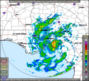
. However, deep convection developed and built westward against the wind shear as the overall organization improved. At the same time Alberto turned northeastward under the influence of an approaching trough. On June 12, the circulation abruptly reformed under the area of deepest convection, which coincided with the storm's passage over the loop current
; consequentially, Alberto quickly strengthened to reach peak winds of 70 mph (115 km/h) about 220 miles (350 km) west-northwest of Tampa, Florida
.
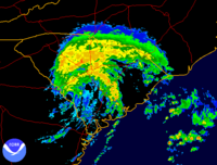
Though it was projected to track over cooler waters and stay in an area of increased shear, forecasters at the National Hurricane Center predicted Alberto would attain hurricane status and make landfall at that intensity. The storm maintained peak intensity for about 18 hours, and while accelerating northeastward, Alberto's convection diminished as the cloud pattern became elongated. On June 13, dry air became entrained in the circulation, leaving the center exposed from the convection and the wind field
greatly broadened. A partial eyewall
developed in the western semicircle of the center; however, winds were well below hurricane force. Alberto continued to weaken, and made landfall
at about on June 13 with 45 mph (75 km/h) winds in Taylor County, Florida
, about 50 miles (80 km) southeast of Tallahassee
.
 The storm maintained a well-organized structure and banding features over land, while continuing to produce winds of tropical storm force as it moved into Georgia
. Early on June 14, the storm weakened to tropical depression status while located near the city of Millen, Georgia
. Alberto began to lose tropical characteristics soon thereafter, and about six hours after weakening to a tropical depression it transitioned into an extratropical cyclone
. Late on June 14 it accelerated northeastward to emerge into the Atlantic Ocean, and on June 15, it entered the area of responsibility of the Canadian Hurricane Centre
. While over open waters, Alberto's remnants began to re-intensify; later that day, the extratropical remnant low attained winds of 65 mph (105 km/h) and a pressure of 969 mbar while a short distance south of Nova Scotia
. At this time, the low presented a well-defined comma structure. After passing near Sable Island
, the remnants of Alberto crossed the Avalon Peninsula
of Newfoundland on June 16. The extratropical storm turned to the east-northeast and later to the east as it continued its rapid forward motion, and on June 19 the remnants of Alberto merged with an approaching cold front
near the British Isles
.
 By June 12, the Cuban government had evacuated over 25,000 people in the western portion of the country due to the threat of flooding. The National Hurricane Center recommended tropical storm warnings for the Isle of Youth
and the Pinar del Río Province
early on June 10, but they were not issued by the Cuban government.
In northwestern Florida, officials issued a mandatory evacuation order a day before the storm moved ashore for about 21,000 citizens in Levy County
, Citrus County
, and Taylor County
. Several schools were closed as well, and converted into shelters. In all, about 350 coastal residents took refuge in emergency shelters. Prior to the arrival of the storm, Florida governor Jeb Bush
declared a state of emergency
for the state. A tropical storm watch was first issued for portions of the Florida Panhandle
about 43 hours prior to landfall. As Alberto was predicted to continue intensifying, the National Hurricane Center issued a hurricane warning from Longboat Key
to the mouth of the Ochlockonee River
approximately 25 hours before landfall. A tropical storm warning extended southward to Englewood
and westward to Indian Pass
. A tropical storm warning was also issued from Flagler Beach, Florida
to the mouth of the Santee River
in South Carolina
. As the storm moved inland, local National Weather Service
offices issued flood watches for portions of North Carolina
, Virginia
, and the Delmarva Peninsula
. Additionally, flood and flash flood warnings were issued for some portions of the country from South Carolina
through Virginia.
While Alberto was becoming extratropical over land, the Canadian Hurricane Centre
issued gale warnings for offshore waters of Nova Scotia
, and later for Newfoundland
. In addition, the Atlantic Storm Prediction Center issued inland wind warnings for coastal regions of Nova Scotia. Due to the prediction for precipitation, the Atlantic Storm Prediction Center posted rainfall warnings for all Atlantic coastal regions of Nova Scotia.
reported 22.72 inches (577 mm) of rain in one 24-hour period. In Cuba
, rainfall amounted to 17.52 inches (445 mm) in Pinar del Río
province, where one station recorded 4.06 inches (103 mm) in one hour. On the Isle of Youth
, precipitation accrued to 15.67 inches (398 mm) in Sumidero. Air and marine travel was disrupted between the Cuban mainland and the Isle of Youth. In Havana Province rainfall totaled 8.46 inches (215 mm) at Playa Baracoa
. Much of the precipitation fell during a fairly short time, and was beneficial, as the area had been suffering from severe drought conditions. In Pinar del Río province, the precipitation flooded 50 sq mi (130 km2 of crop land. The storm damaged about 50 houses across the country, about half of which in Havana
.
Alberto dropped light amounts of rainfall across Mexico
, with a 24-hour total peaking at 4 inches (100 mm) in Peto, Yucatán
. Light rain was also reported throughout Quintana Roo
and in eastern Campeche
.
. The highest sustained winds from the storm were officially clocked at 40 mph (65 km/h) in St. Petersburg, which also saw reports of wind gusts of up to 56 mph (90 km/h). Upon making landfall on the Florida Panhandle
, the storm produced a storm tide
which unofficially peaked at 7.3 feet (2.2 m) at Crystal River Power Plant
. The combination of high surf and the storm tide caused surge flooding along the Florida Panhandle
. Six tornadoes were spawned in the state from the outer rainbands of Alberto, none of which caused serious damage.
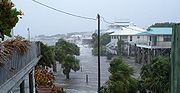 Across coastal areas, the storm surge flooding caused minor damage to dozens of homes and closed several roads. Near Homosassa
, two people who did not evacuate required water rescue. At Egmont Key State Park
, a woman fell off of a boat when a band of showers and surging currents made navigation difficult; her husband and a friend drowned after jumping in to save her without life jackets, though the woman returned safely to the boat. The rainfall caused some temporary road flooding, though precipitation was mostly beneficial in alleviating drought conditions. Moderate wind gusts caused scattered power outages and downed some trees across the northeast portion of the state. Overall, property damage in the state rose to about $390,000 (2006 USD) in total.
 While the storm moved through the state of Georgia
, moderate winds of up to 45 mph (72 km/h) occurred along the coastline. Rainfall ranged from 3–5 inches (75–125 mm) across the southeast portion of the state, with isolated higher maxima of up to 7.05 inches (179 mm) in Rincon
. Alberto produced a storm tide
of 8.53 feet (2.6 m) at Fort Pulaski National Monument
, causing some beach erosion along the coastline.
Alberto produced winds of tropical storm force along the South Carolina
coastline; the highest official wind gust was 51 mph (82 km/h) at Edisto Beach
. The storm dropped precipitation across much of the state, including a state maximum of 4.42 inches (112 mm) at Pritchardville
. Storm tide
s reached 7.81 feet (2.4 m) above the mean low-level water mark along Fripp Island, leading to some beach erosion
along portions of the coastline. While in the process of becoming extratropical, the rainbands of Alberto spawned seven confirmed tornado
es in the state, most of which rated F0
; a National Weather Service
report indicated additional tornadoes may have occurred in the state. The tornadoes caused some minor damage, though overall damage in the state was minimal.
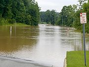
The remnants of Alberto dropped heavy precipitation across North Carolina
, including a nation-wide high of 7.16 inches (182 mm) at the Raleigh
National Weather Service Office. Some totals broke previous rainfall records, including the station at Raleigh-Durham International Airport
which broke the all-time daily precipitation record for that station. The rainfall led to flooding across the central portion of the state, with 45 flash flood warnings issued by the Raleigh National Weather Service. Police and firefighters in Wake County
performed 47 water rescues. Additionally, the Raleigh-Wake 9-1-1
center received more than 1,076 calls for help. Flash flooding occurred throughout the area, which caused the Crabtree Creek in Raleigh to crest at 23.77 feet (7.2 m); this was the second highest flood stage on record for the creek. The overflown creek flooded a few cars to their rooftops, and resulted in the closure of the Crabtree Valley Mall
. Major flooding was reported elsewhere throughout the region, which closed several roads and damaged some houses. In Franklin County
, an eight year-old boy drowned after getting sucked into a flooded drainage system; the death is considered indirect because the boy was chasing a ball into the drainage system. Near the coast, the storm produced several waterspout
s, some of which moved ashore in Dare
and Carteret counties
. Isolated reports of 60 mph (95 km/h) wind gusts resulted in downed trees and minor damage.
Rainfall from the storm extended into Virginia
, the Eastern Shore of Maryland
, and extreme southeastern Delaware
. Precipitation totaled 5.8 inches (147 mm) in Virginia Beach, which caused flash flooding in the Hampton Roads
area. The flooding closed several roads, though no major damage was reported.
district of Nova Scotia
. Sustained winds reached 51 mph (83 km/h). Rainfall from the storm was moderate, with some locations reporting 0.4 inches (10 mm) per hour; totals exceeded 2 inches (50 mm) in numerous areas. Due to wet grounds, the winds knocked down some trees and several tree limbs, and also downed some power lines, causing localized power outages. Moderate winds and rainfall affected Newfoundland
, as well. According to a press report, the storm left four sailors missing about 230 miles (370 km) south of Nova Scotia.
Tropical cyclone
A tropical cyclone is a storm system characterized by a large low-pressure center and numerous thunderstorms that produce strong winds and heavy rain. Tropical cyclones strengthen when water evaporated from the ocean is released as the saturated air rises, resulting in condensation of water vapor...
of the 2006 Atlantic hurricane season
2006 Atlantic hurricane season
The 2006 Atlantic hurricane season was significantly less active than the record previous season. It marked the first since 2001 in which no hurricanes made landfall in the United States, and was the first since 1994 that no tropical cyclones formed during October. Following the intense activity of...
. Forming on June 10 in the northwestern Caribbean, the storm moved generally to the north, reaching a maximum intensity of 70 mph (110 km/h) before weakening and moving ashore in the Big Bend
Big Bend (Florida)
The Big Bend of Florida, U.S.A., is an informal region of the state with no official surveyed boundary. It includes part of the counties of the Florida Panhandle. Geologists prefer to characterize Florida’s Big Bend as the drowned karst section of the coast that occurs between the mouth of the...
area of Florida
Florida
Florida is a state in the southeastern United States, located on the nation's Atlantic and Gulf coasts. It is bordered to the west by the Gulf of Mexico, to the north by Alabama and Georgia and to the east by the Atlantic Ocean. With a population of 18,801,310 as measured by the 2010 census, it...
on June 13. Alberto then moved through eastern Georgia
Georgia (U.S. state)
Georgia is a state located in the southeastern United States. It was established in 1732, the last of the original Thirteen Colonies. The state is named after King George II of Great Britain. Georgia was the fourth state to ratify the United States Constitution, on January 2, 1788...
, North Carolina
North Carolina
North Carolina is a state located in the southeastern United States. The state borders South Carolina and Georgia to the south, Tennessee to the west and Virginia to the north. North Carolina contains 100 counties. Its capital is Raleigh, and its largest city is Charlotte...
, and Virginia
Virginia
The Commonwealth of Virginia , is a U.S. state on the Atlantic Coast of the Southern United States. Virginia is nicknamed the "Old Dominion" and sometimes the "Mother of Presidents" after the eight U.S. presidents born there...
as a tropical depression before becoming extratropical on June 14.
Across the Western Caribbean, the storm produced heavy rainfall, causing some minor damage. In Florida, a moderate storm tide
Storm tide
A storm tide is a tide with a high flood period caused by a storm. Storm tides can be a severe danger to the coast and the people living along the coast. The water level can rise to more than 5 meters above the normal tide....
caused coastal damage and flooding, while Alberto's outer rainbands produced several tornadoes. The storm was indirectly responsible for two drownings off the coast of Tampa Bay
Tampa Bay
Tampa Bay is a large natural harbor and estuary along the Gulf of Mexico on the west central coast of Florida, comprising Hillsborough Bay, Old Tampa Bay, Middle Tampa Bay, and Lower Tampa Bay."Tampa Bay" is not the name of any municipality...
. In North Carolina
North Carolina
North Carolina is a state located in the southeastern United States. The state borders South Carolina and Georgia to the south, Tennessee to the west and Virginia to the north. North Carolina contains 100 counties. Its capital is Raleigh, and its largest city is Charlotte...
, heavy rainfall caused locally severe flooding, and one child drowned in a flooded storm drain near Raleigh
Raleigh, North Carolina
Raleigh is the capital and the second largest city in the state of North Carolina as well as the seat of Wake County. Raleigh is known as the "City of Oaks" for its many oak trees. According to the U.S. Census Bureau, the city's 2010 population was 403,892, over an area of , making Raleigh...
. The remnants of Alberto produced strong winds and left four people missing in Atlantic Canada
Atlantic Canada
Atlantic Canada is the region of Canada comprising the four provinces located on the Atlantic coast, excluding Quebec: the three Maritime provinces – New Brunswick, Prince Edward Island, and Nova Scotia – and Newfoundland and Labrador...
. Overall, damage was minor along Alberto's path.
Meteorological history
In early June 2006, an area of convectionAtmospheric convection
Atmospheric convection is the result of a parcel-environment instability, or temperature difference, layer in the atmosphere. Different lapse rates within dry and moist air lead to instability. Mixing of air during the day which expands the height of the planetary boundary layer leads to...
persisted across Central America and the western Caribbean in association with a broad, nearly stationary trough
Trough (meteorology)
A trough is an elongated region of relatively low atmospheric pressure, often associated with fronts.Unlike fronts, there is not a universal symbol for a trough on a weather chart. The weather charts in some countries or regions mark troughs by a line. In the United States, a trough may be marked...
of low pressure
Low pressure area
A low-pressure area, or "low", is a region where the atmospheric pressure at sea level is below that of surrounding locations. Low-pressure systems form under areas of wind divergence which occur in upper levels of the troposphere. The formation process of a low-pressure area is known as...
. Thunderstorms increased and became more concentrated on June 8 after a tropical wave
Tropical wave
Tropical waves, easterly waves, or tropical easterly waves, also known as African easterly waves in the Atlantic region, are a type of atmospheric trough, an elongated area of relatively low air pressure, oriented north to south, which move from east to west across the tropics causing areas of...
moved into the western Caribbean, and an upper-level low to its west increased outflow
Outflow (meteorology)
Outflow, in meteorology, is air that flows outwards from a storm system. It is associated with ridging, or anticyclonic flow. In the low levels of the troposphere, outflow radiates from thunderstorms in the form of a wedge of rain-cooled air, which is visible as a thin rope-like cloud on weather...
over the system. The disturbance moved slowly north-northwestward, and development
Tropical cyclogenesis
Tropical cyclogenesis is the term that describes the development and strengthening of a tropical cyclone in the atmosphere. The mechanisms through which tropical cyclogenesis occurs are distinctly different from those through which mid-latitude cyclogenesis occurs...
was initially inhibited by marginally favorable upper-level winds and land interaction. The system gradually organized
Tropical cyclogenesis
Tropical cyclogenesis is the term that describes the development and strengthening of a tropical cyclone in the atmosphere. The mechanisms through which tropical cyclogenesis occurs are distinctly different from those through which mid-latitude cyclogenesis occurs...
, and by June 10 a circulation formed with sufficiently organized convection for the National Hurricane Center
National Hurricane Center
The National Hurricane Center , located at Florida International University in Miami, Florida, is the division of the National Weather Service responsible for tracking and predicting weather systems within the tropics between the Prime Meridian and the 140th meridian west poleward to the 30th...
to classify it Tropical Depression One. At this point the storm was located about 140 miles (225 km) south of the western tip of Cuba
Cuba
The Republic of Cuba is an island nation in the Caribbean. The nation of Cuba consists of the main island of Cuba, the Isla de la Juventud, and several archipelagos. Havana is the largest city in Cuba and the country's capital. Santiago de Cuba is the second largest city...
.
The depression tracked to the northwest through the Yucatán Channel
Yucatán Channel
The Yucatán Channel is a strait between Mexico and Cuba. It connects the Yucatán Basin of the Caribbean Sea with the Gulf of Mexico. The strait is across between Cape Catoche in Mexico and Cape San Antonio, Cuba and reaches a maximum depth of .-References:...
into an area of increased wind shear
Wind shear
Wind shear, sometimes referred to as windshear or wind gradient, is a difference in wind speed and direction over a relatively short distance in the atmosphere...
, which left the center exposed and elongated. Despite its poor structure, the system maintained strong winds in its eastern semicircle. The depression intensified into Tropical Storm Alberto early on June 11 about 260 miles (420 km) southwest of the Dry Tortugas
Dry Tortugas
The Dry Tortugas are a small group of islands, located at the end of the Florida Keys, USA, about west of Key West, and west of the Marquesas Keys, the closest islands. Still further west is the Tortugas Bank, which is completely submerged. The first Europeans to discover the islands were the...
, based on Hurricane Hunters
Hurricane Hunters
The Hurricane Hunters are aircraft that fly into tropical cyclones in the North Atlantic Ocean and Northeastern Pacific Ocean for the specific purpose of directly measuring weather data in and around those storms. In the United States, the Air Force, Navy, and NOAA units have all participated in...
' reports of flight level winds of 50 mph (80 km/h) in a few convective bands. Upon becoming a tropical storm, the low-level circulation had become better defined, though forecasts predicted the wind shear would increase, preventing significant strengthening of the storm. One forecaster at the National Hurricane Center remarked the system resembled a subtropical cyclone
Subtropical cyclone
A subtropical cyclone is a weather system that has some characteristics of a tropical and an extratropical cyclone. As early as the 1950s, meteorologists were unclear whether they should be characterized as tropical or extratropical cyclones. They were officially recognized by the National...
. However, deep convection developed and built westward against the wind shear as the overall organization improved. At the same time Alberto turned northeastward under the influence of an approaching trough. On June 12, the circulation abruptly reformed under the area of deepest convection, which coincided with the storm's passage over the loop current
Loop Current
A parent to the Florida Current, the Loop Current is a warm ocean current in the Gulf of Mexico that flows northward between Cuba and the Yucatán peninsula, moves north into the Gulf of Mexico, loops east and south before exiting to the east through the Florida Straits and joining the Gulf Stream.A...
; consequentially, Alberto quickly strengthened to reach peak winds of 70 mph (115 km/h) about 220 miles (350 km) west-northwest of Tampa, Florida
Tampa, Florida
Tampa is a city in the U.S. state of Florida. It serves as the county seat for Hillsborough County. Tampa is located on the west coast of Florida. The population of Tampa in 2010 was 335,709....
.
Though it was projected to track over cooler waters and stay in an area of increased shear, forecasters at the National Hurricane Center predicted Alberto would attain hurricane status and make landfall at that intensity. The storm maintained peak intensity for about 18 hours, and while accelerating northeastward, Alberto's convection diminished as the cloud pattern became elongated. On June 13, dry air became entrained in the circulation, leaving the center exposed from the convection and the wind field
Radius of maximum wind
The radius of maximum wind is the distance between the center of a cyclone and its band of strongest winds. It is a parameter in atmospheric dynamics and tropical cyclone forecasting. The highest rainfall rates occur near the RMW of tropical cyclones. The extent of a cyclone's storm surge and...
greatly broadened. A partial eyewall
Eye (cyclone)
The eye is a region of mostly calm weather found at the center of strong tropical cyclones. The eye of a storm is a roughly circular area and typically 30–65 km in diameter. It is surrounded by the eyewall, a ring of towering thunderstorms where the second most severe weather of a cyclone...
developed in the western semicircle of the center; however, winds were well below hurricane force. Alberto continued to weaken, and made landfall
Landfall (meteorology)
Landfall is the event of a tropical cyclone or a waterspout coming onto land after being over water. When a waterspout makes landfall it is reclassified as a tornado, which can then cause damage inland...
at about on June 13 with 45 mph (75 km/h) winds in Taylor County, Florida
Taylor County, Florida
Taylor County is a county located in the state of Florida. As of 2000, the population was 19,256. The U.S. Census Bureau 2005 estimate for the county was 19,622 . Its county seat is Perry, Florida.- History :Taylor County was created in 1856...
, about 50 miles (80 km) southeast of Tallahassee
Tallahassee, Florida
Tallahassee is the capital of the U.S. state of Florida. It is the county seat and only incorporated municipality in Leon County, and is the 128th largest city in the United States. Tallahassee became the capital of Florida, then the Florida Territory, in 1824. In 2010, the population recorded by...
.
Georgia (U.S. state)
Georgia is a state located in the southeastern United States. It was established in 1732, the last of the original Thirteen Colonies. The state is named after King George II of Great Britain. Georgia was the fourth state to ratify the United States Constitution, on January 2, 1788...
. Early on June 14, the storm weakened to tropical depression status while located near the city of Millen, Georgia
Millen, Georgia
Millen is a city in Jenkins County, Georgia, United States. The population was 3,492 at the 2000 census, a decline of 8.3% since 1990, during a decade in which the state's population grew by 26.4%.The city, centered near the intersection of U.S...
. Alberto began to lose tropical characteristics soon thereafter, and about six hours after weakening to a tropical depression it transitioned into an extratropical cyclone
Extratropical cyclone
Extratropical cyclones, sometimes called mid-latitude cyclones or wave cyclones, are a group of cyclones defined as synoptic scale low pressure weather systems that occur in the middle latitudes of the Earth having neither tropical nor polar characteristics, and are connected with fronts and...
. Late on June 14 it accelerated northeastward to emerge into the Atlantic Ocean, and on June 15, it entered the area of responsibility of the Canadian Hurricane Centre
Canadian Hurricane Centre
The Canadian Hurricane Centre is a division of the Meteorological Service of Canada, an agency of Canada's Department of the Environment, which exists to advise Canadians on the threat of tropical cyclones such as hurricanes and tropical storms...
. While over open waters, Alberto's remnants began to re-intensify; later that day, the extratropical remnant low attained winds of 65 mph (105 km/h) and a pressure of 969 mbar while a short distance south of Nova Scotia
Nova Scotia
Nova Scotia is one of Canada's three Maritime provinces and is the most populous province in Atlantic Canada. The name of the province is Latin for "New Scotland," but "Nova Scotia" is the recognized, English-language name of the province. The provincial capital is Halifax. Nova Scotia is the...
. At this time, the low presented a well-defined comma structure. After passing near Sable Island
Sable Island
Sable Island is a small Canadian island situated 300 km southeast of mainland Nova Scotia in the Atlantic Ocean. The island is a year-round home to approximately five people...
, the remnants of Alberto crossed the Avalon Peninsula
Avalon Peninsula
The Avalon Peninsula is a large peninsula that makes up the southeast portion of the island of Newfoundland.The peninsula is home to 257,223 people, which is approximately 51% of Newfoundland's population in 2009, and is the location of the provincial capital, St. John's. It is connected to the...
of Newfoundland on June 16. The extratropical storm turned to the east-northeast and later to the east as it continued its rapid forward motion, and on June 19 the remnants of Alberto merged with an approaching cold front
Cold front
A cold front is defined as the leading edge of a cooler mass of air, replacing a warmer mass of air.-Development of cold front:The cooler and denser air wedges under the less-dense warmer air, lifting it...
near the British Isles
British Isles
The British Isles are a group of islands off the northwest coast of continental Europe that include the islands of Great Britain and Ireland and over six thousand smaller isles. There are two sovereign states located on the islands: the United Kingdom of Great Britain and Northern Ireland and...
.
Preparations
Isle of Youth
Isla de la Juventud is the second-largest Cuban island and the seventh-largest island in the West Indies . The island has an area and is 100 km south of the island of Cuba, across the Gulf of Batabanó...
and the Pinar del Río Province
Pinar del Río Province
Pinar del Río is one of the provinces of Cuba. It is at the western end of the island of Cuba.-Geography:The Pinar del Río province is Cuba's westernmost province and contains one of Cuba's three main mountain ranges, the Cordillera de Guaniguanico, divided into the easterly Sierra del Rosario and...
early on June 10, but they were not issued by the Cuban government.
In northwestern Florida, officials issued a mandatory evacuation order a day before the storm moved ashore for about 21,000 citizens in Levy County
Levy County, Florida
Levy County is a county located in the state of Florida. As of 2000, the population was 34,450. The U.S. Census Bureau 2005 estimate for the county is 37,998. Its county seat is Bronson, Florida. Levy is pronounced lee vee.- History :...
, Citrus County
Citrus County, Florida
Citrus County is a county located in the U.S. state of Florida. As of 2000, the population was 118,085. The U.S. Census Bureau 2008 estimate for the county was 141,416 . Its county seat is Inverness, Florida...
, and Taylor County
Taylor County, Florida
Taylor County is a county located in the state of Florida. As of 2000, the population was 19,256. The U.S. Census Bureau 2005 estimate for the county was 19,622 . Its county seat is Perry, Florida.- History :Taylor County was created in 1856...
. Several schools were closed as well, and converted into shelters. In all, about 350 coastal residents took refuge in emergency shelters. Prior to the arrival of the storm, Florida governor Jeb Bush
Jeb Bush
John Ellis "Jeb" Bush is an American politician who served as the 43rd Governor of Florida from 1999 to 2007. He is a prominent member of the Bush family: the second son of former President George H. W. Bush and former First Lady Barbara Bush; the younger brother of former President George W...
declared a state of emergency
State of emergency
A state of emergency is a governmental declaration that may suspend some normal functions of the executive, legislative and judicial powers, alert citizens to change their normal behaviours, or order government agencies to implement emergency preparedness plans. It can also be used as a rationale...
for the state. A tropical storm watch was first issued for portions of the Florida Panhandle
Florida Panhandle
The Florida Panhandle, an informal, unofficial term for the northwestern part of Florida, is a strip of land roughly 200 miles long and 50 to 100 miles wide , lying between Alabama on the north and the west, Georgia also on the north, and the Gulf of Mexico to the south. Its eastern boundary is...
about 43 hours prior to landfall. As Alberto was predicted to continue intensifying, the National Hurricane Center issued a hurricane warning from Longboat Key
Longboat Key, Florida
Longboat Key is a town in Manatee and Sarasota counties along the central west coast of the U.S. state of Florida, located on the barrier island of the same name. Longboat Key is south of Anna Maria Island, between Sarasota Bay and the Gulf of Mexico. It is almost equally divided between Manatee...
to the mouth of the Ochlockonee River
Ochlockonee River
The Ochlockonee River is a fast running river originating in Georgia and flowing for before terminating in Florida.- Background :The Ochlockonee originates south of the town of Sylvester in Worth County in southwest Georgia emptying into Ochlockonee Bay, then into Apalachee Bay, in Florida...
approximately 25 hours before landfall. A tropical storm warning extended southward to Englewood
Englewood, Florida
Englewood is a census-designated place in Charlotte and Sarasota counties in the U.S. state of Florida. As of the 2000 census, it had a population of 16,196.Englewood also was the original name for Vineland, Florida...
and westward to Indian Pass
Indian Pass, Florida
Indian Pass is a small area on the south coast of Gulf County, Florida, 8 miles south of Port St. Joe. It promotes itself as an uncrowded haven for sports fisherman and water enthusiasts, and for dining featuring locally caught oysters. A ferry provides access to a wildlife sanctuary on St Vincent...
. A tropical storm warning was also issued from Flagler Beach, Florida
Flagler Beach, Florida
Flagler Beach is a city in Flagler and Volusia counties in the U.S. state of Florida. The population was 4,954 at the 2000 census, with an estimated population of 5,228 in 2004.Flagler Beach is part of the Palm Coast Metropolitan Statistical Area...
to the mouth of the Santee River
Santee River
The Santee River is a river in South Carolina in the United States, long. The Santee and its tributaries provide the principal drainage and navigation for the central coastal plain of South Carolina, emptying into the Atlantic Ocean approximately from its farthest headwater on the Catawba River...
in South Carolina
South Carolina
South Carolina is a state in the Deep South of the United States that borders Georgia to the south, North Carolina to the north, and the Atlantic Ocean to the east. Originally part of the Province of Carolina, the Province of South Carolina was one of the 13 colonies that declared independence...
. As the storm moved inland, local National Weather Service
National Weather Service
The National Weather Service , once known as the Weather Bureau, is one of the six scientific agencies that make up the National Oceanic and Atmospheric Administration of the United States government...
offices issued flood watches for portions of North Carolina
North Carolina
North Carolina is a state located in the southeastern United States. The state borders South Carolina and Georgia to the south, Tennessee to the west and Virginia to the north. North Carolina contains 100 counties. Its capital is Raleigh, and its largest city is Charlotte...
, Virginia
Virginia
The Commonwealth of Virginia , is a U.S. state on the Atlantic Coast of the Southern United States. Virginia is nicknamed the "Old Dominion" and sometimes the "Mother of Presidents" after the eight U.S. presidents born there...
, and the Delmarva Peninsula
Delmarva Peninsula
The Delmarva Peninsula is a large peninsula on the East Coast of the United States, occupied by most of Delaware and portions of Maryland and Virginia...
. Additionally, flood and flash flood warnings were issued for some portions of the country from South Carolina
South Carolina
South Carolina is a state in the Deep South of the United States that borders Georgia to the south, North Carolina to the north, and the Atlantic Ocean to the east. Originally part of the Province of Carolina, the Province of South Carolina was one of the 13 colonies that declared independence...
through Virginia.
While Alberto was becoming extratropical over land, the Canadian Hurricane Centre
Canadian Hurricane Centre
The Canadian Hurricane Centre is a division of the Meteorological Service of Canada, an agency of Canada's Department of the Environment, which exists to advise Canadians on the threat of tropical cyclones such as hurricanes and tropical storms...
issued gale warnings for offshore waters of Nova Scotia
Nova Scotia
Nova Scotia is one of Canada's three Maritime provinces and is the most populous province in Atlantic Canada. The name of the province is Latin for "New Scotland," but "Nova Scotia" is the recognized, English-language name of the province. The provincial capital is Halifax. Nova Scotia is the...
, and later for Newfoundland
Newfoundland and Labrador
Newfoundland and Labrador is the easternmost province of Canada. Situated in the country's Atlantic region, it incorporates the island of Newfoundland and mainland Labrador with a combined area of . As of April 2011, the province's estimated population is 508,400...
. In addition, the Atlantic Storm Prediction Center issued inland wind warnings for coastal regions of Nova Scotia. Due to the prediction for precipitation, the Atlantic Storm Prediction Center posted rainfall warnings for all Atlantic coastal regions of Nova Scotia.
Caribbean
In its early stages of development, the tropical depression which later became Alberto produced heavy rainfall across the western Caribbean. A station on Grand CaymanGrand Cayman
Grand Cayman is the largest of the three Cayman Islands and the location of the nation's capital, George Town. In relation to the other two Cayman Islands, it is approximately 75 miles southwest of Little Cayman and 90 miles southwest of Cayman Brac.-Geography:Grand Cayman encompasses 76% of...
reported 22.72 inches (577 mm) of rain in one 24-hour period. In Cuba
Cuba
The Republic of Cuba is an island nation in the Caribbean. The nation of Cuba consists of the main island of Cuba, the Isla de la Juventud, and several archipelagos. Havana is the largest city in Cuba and the country's capital. Santiago de Cuba is the second largest city...
, rainfall amounted to 17.52 inches (445 mm) in Pinar del Río
Pinar del Río
Pinar del Río is a city in Cuba. It is the capital of Pinar del Río Province.Inhabitants of the area are called Pinareños.Neighborhoods in the city include La Conchita, La Coloma, Briones Montoto and Las Ovas.-History:...
province, where one station recorded 4.06 inches (103 mm) in one hour. On the Isle of Youth
Isle of Youth
Isla de la Juventud is the second-largest Cuban island and the seventh-largest island in the West Indies . The island has an area and is 100 km south of the island of Cuba, across the Gulf of Batabanó...
, precipitation accrued to 15.67 inches (398 mm) in Sumidero. Air and marine travel was disrupted between the Cuban mainland and the Isle of Youth. In Havana Province rainfall totaled 8.46 inches (215 mm) at Playa Baracoa
Playa Baracoa Airport
Playa Baracoa Airport is a regional airport west of Havana, Cuba that serves regional flights in Cuba.-Playa Baracoa Air Base:The airport is an inactive Cuban Revolutionary Armed Forces air base and home to Air Defense Command and VIP transport:...
. Much of the precipitation fell during a fairly short time, and was beneficial, as the area had been suffering from severe drought conditions. In Pinar del Río province, the precipitation flooded 50 sq mi (130 km2 of crop land. The storm damaged about 50 houses across the country, about half of which in Havana
Havana
Havana is the capital city, province, major port, and leading commercial centre of Cuba. The city proper has a population of 2.1 million inhabitants, and it spans a total of — making it the largest city in the Caribbean region, and the most populous...
.
Alberto dropped light amounts of rainfall across Mexico
Mexico
The United Mexican States , commonly known as Mexico , is a federal constitutional republic in North America. It is bordered on the north by the United States; on the south and west by the Pacific Ocean; on the southeast by Guatemala, Belize, and the Caribbean Sea; and on the east by the Gulf of...
, with a 24-hour total peaking at 4 inches (100 mm) in Peto, Yucatán
Peto, Yucatán
Peto is one of 106 municipalities in Yucatán state, Mexico. It has a municipal seat of the same name and is located in the centre-south portion of the Mexican state of Yucatán, 135 km to the south-east of state capital Mérida.-Communities:...
. Light rain was also reported throughout Quintana Roo
Quintana Roo
Quintana Roo officially Estado Libre y Soberano de Quintana Roo is one of the 31 states which, with the Federal District, comprise the 32 Federal Entities of Mexico. It is divided in 10 municipalities and its capital city is Chetumal....
and in eastern Campeche
Campeche
Campeche is one of the 31 states which, with the Federal District, comprise the 32 Federal Entities of Mexico. Located in Southeast Mexico, it is bordered by the states of Yucatán to the north east, Quintana Roo to the east, and Tabasco to the south west...
.
Florida
The large area of convection associated with Alberto dropped rainfall across Florida for several days. The statewide precipitation maximum reached 7.08 inches (180 mm) at a station 5 miles (8 km) east of Tarpon SpringsTarpon Springs, Florida
Tarpon Springs is a city in Pinellas County, Florida, United States. The population was 21,003 at the 2000 census. According to the U.S. Census Bureau's 2004 estimates, the city had a population of 22,554....
. The highest sustained winds from the storm were officially clocked at 40 mph (65 km/h) in St. Petersburg, which also saw reports of wind gusts of up to 56 mph (90 km/h). Upon making landfall on the Florida Panhandle
Florida Panhandle
The Florida Panhandle, an informal, unofficial term for the northwestern part of Florida, is a strip of land roughly 200 miles long and 50 to 100 miles wide , lying between Alabama on the north and the west, Georgia also on the north, and the Gulf of Mexico to the south. Its eastern boundary is...
, the storm produced a storm tide
Storm tide
A storm tide is a tide with a high flood period caused by a storm. Storm tides can be a severe danger to the coast and the people living along the coast. The water level can rise to more than 5 meters above the normal tide....
which unofficially peaked at 7.3 feet (2.2 m) at Crystal River Power Plant
Crystal River 3 Nuclear Generating Station
The Crystal River 3 Nuclear Power Plant, also simply called the Crystal River Nuclear Plant, is a nuclear power plant located in Crystal River, Florida...
. The combination of high surf and the storm tide caused surge flooding along the Florida Panhandle
Florida Panhandle
The Florida Panhandle, an informal, unofficial term for the northwestern part of Florida, is a strip of land roughly 200 miles long and 50 to 100 miles wide , lying between Alabama on the north and the west, Georgia also on the north, and the Gulf of Mexico to the south. Its eastern boundary is...
. Six tornadoes were spawned in the state from the outer rainbands of Alberto, none of which caused serious damage.
Homosassa, Florida
Homosassa is a census-designated place in Citrus County, Florida, United States. The population was 2,294 at the 2000 census.-Historic:...
, two people who did not evacuate required water rescue. At Egmont Key State Park
Egmont Key State Park
Egmont Key State Park is a Florida State Park located on Egmont Key, at the mouth of Tampa Bay, in the state of Florida, United States. It lies southwest of Fort DeSoto Park. It can only be reached by boat or ferry. The Egmont Key Lighthouse and the ruins of Fort Dade, a Spanish-American War era...
, a woman fell off of a boat when a band of showers and surging currents made navigation difficult; her husband and a friend drowned after jumping in to save her without life jackets, though the woman returned safely to the boat. The rainfall caused some temporary road flooding, though precipitation was mostly beneficial in alleviating drought conditions. Moderate wind gusts caused scattered power outages and downed some trees across the northeast portion of the state. Overall, property damage in the state rose to about $390,000 (2006 USD) in total.
Southeast United States
Georgia (U.S. state)
Georgia is a state located in the southeastern United States. It was established in 1732, the last of the original Thirteen Colonies. The state is named after King George II of Great Britain. Georgia was the fourth state to ratify the United States Constitution, on January 2, 1788...
, moderate winds of up to 45 mph (72 km/h) occurred along the coastline. Rainfall ranged from 3–5 inches (75–125 mm) across the southeast portion of the state, with isolated higher maxima of up to 7.05 inches (179 mm) in Rincon
Rincon, Georgia
Rincon is a city in Effingham County, Georgia, United States. The population was 4,376 at the 2000 census. It is part of the Savannah Metropolitan Statistical Area.-History:...
. Alberto produced a storm tide
Storm tide
A storm tide is a tide with a high flood period caused by a storm. Storm tides can be a severe danger to the coast and the people living along the coast. The water level can rise to more than 5 meters above the normal tide....
of 8.53 feet (2.6 m) at Fort Pulaski National Monument
Fort Pulaski National Monument
Fort Pulaski National Monument is located between Savannah and Tybee Island, Georgia. It preserves Fort Pulaski, notable as the place where, during the American Civil War, in 1862, the Union Army successfully tested a rifled cannon. The success of the test rendered brick fortifications obsolete....
, causing some beach erosion along the coastline.
Alberto produced winds of tropical storm force along the South Carolina
South Carolina
South Carolina is a state in the Deep South of the United States that borders Georgia to the south, North Carolina to the north, and the Atlantic Ocean to the east. Originally part of the Province of Carolina, the Province of South Carolina was one of the 13 colonies that declared independence...
coastline; the highest official wind gust was 51 mph (82 km/h) at Edisto Beach
Edisto Beach, South Carolina
Edisto Beach is a town in Colleton County, South Carolina, United States. The population was 641 at the 2000 census. The town limits include only the coastal area of Edisto Island .-History:Edisto Beach was originally settled by the Edisto Indians and was discovered...
. The storm dropped precipitation across much of the state, including a state maximum of 4.42 inches (112 mm) at Pritchardville
Pritchardville, South Carolina
Pritchardville is an unincorporated community in Beaufort County, South Carolina, United States, located between Hardeeville and Bluffton on South Carolina Highway 46. The community takes its name from nearby Pritchard Farms....
. Storm tide
Storm tide
A storm tide is a tide with a high flood period caused by a storm. Storm tides can be a severe danger to the coast and the people living along the coast. The water level can rise to more than 5 meters above the normal tide....
s reached 7.81 feet (2.4 m) above the mean low-level water mark along Fripp Island, leading to some beach erosion
Erosion
Erosion is when materials are removed from the surface and changed into something else. It only works by hydraulic actions and transport of solids in the natural environment, and leads to the deposition of these materials elsewhere...
along portions of the coastline. While in the process of becoming extratropical, the rainbands of Alberto spawned seven confirmed tornado
Tornado
A tornado is a violent, dangerous, rotating column of air that is in contact with both the surface of the earth and a cumulonimbus cloud or, in rare cases, the base of a cumulus cloud. They are often referred to as a twister or a cyclone, although the word cyclone is used in meteorology in a wider...
es in the state, most of which rated F0
Fujita scale
The Fujita scale , or Fujita-Pearson scale, is a scale for rating tornado intensity, based primarily on the damage tornadoes inflict on human-built structures and vegetation...
; a National Weather Service
National Weather Service
The National Weather Service , once known as the Weather Bureau, is one of the six scientific agencies that make up the National Oceanic and Atmospheric Administration of the United States government...
report indicated additional tornadoes may have occurred in the state. The tornadoes caused some minor damage, though overall damage in the state was minimal.
The remnants of Alberto dropped heavy precipitation across North Carolina
North Carolina
North Carolina is a state located in the southeastern United States. The state borders South Carolina and Georgia to the south, Tennessee to the west and Virginia to the north. North Carolina contains 100 counties. Its capital is Raleigh, and its largest city is Charlotte...
, including a nation-wide high of 7.16 inches (182 mm) at the Raleigh
Raleigh, North Carolina
Raleigh is the capital and the second largest city in the state of North Carolina as well as the seat of Wake County. Raleigh is known as the "City of Oaks" for its many oak trees. According to the U.S. Census Bureau, the city's 2010 population was 403,892, over an area of , making Raleigh...
National Weather Service Office. Some totals broke previous rainfall records, including the station at Raleigh-Durham International Airport
Raleigh-Durham International Airport
Raleigh-Durham International Airport is a public international airport located 4.5 miles northeast of the town of Morrisville in suburban Wake County, North Carolina, United States. The airport covers and operates three runways, providing direct service to 40 domestic and international...
which broke the all-time daily precipitation record for that station. The rainfall led to flooding across the central portion of the state, with 45 flash flood warnings issued by the Raleigh National Weather Service. Police and firefighters in Wake County
Wake County, North Carolina
Wake County is a county located in the U.S. state of North Carolina. As of the 2010 census, the population was 900,993 making it North Carolina's second most populated county...
performed 47 water rescues. Additionally, the Raleigh-Wake 9-1-1
9-1-1
9-1-1 is the emergency telephone number for the North American Numbering Plan .It is one of eight N11 codes.The use of this number is for emergency circumstances only, and to use it for any other purpose can be a crime.-History:In the earliest days of telephone technology, prior to the...
center received more than 1,076 calls for help. Flash flooding occurred throughout the area, which caused the Crabtree Creek in Raleigh to crest at 23.77 feet (7.2 m); this was the second highest flood stage on record for the creek. The overflown creek flooded a few cars to their rooftops, and resulted in the closure of the Crabtree Valley Mall
Crabtree Valley Mall
Crabtree Valley Mall is a regional mall located in Raleigh, North Carolina. At , it is the largest enclosed mall in the Triangle. Crabtree Valley contains over 220 stores and is anchored by Belk, Sears, and Macy's. Higher-end restaurants located in the mall include The Cheesecake Factory, P. F...
. Major flooding was reported elsewhere throughout the region, which closed several roads and damaged some houses. In Franklin County
Franklin County, North Carolina
-Demographics:As of the census of 2000, there were 47,260 people, 17,843 households, and 12,882 families residing in the county. The population density was 96 people per square mile . There were 20,364 housing units at an average density of 41 per square mile...
, an eight year-old boy drowned after getting sucked into a flooded drainage system; the death is considered indirect because the boy was chasing a ball into the drainage system. Near the coast, the storm produced several waterspout
Waterspout
A waterspout is an intense columnar vortex that occurs over a body of water and is connected to a cumuliform cloud. In the common form, it is a non-supercell tornado over water. While it is often weaker than most of its land counterparts, stronger versions spawned by mesocyclones do occur...
s, some of which moved ashore in Dare
Dare County, North Carolina
-National protected areas:* Alligator River National Wildlife Refuge * Cape Hatteras National Seashore * Fort Raleigh National Historic Site* Pea Island National Wildlife Refuge* Wright Brothers National Memorial-Demographics:...
and Carteret counties
Carteret County, North Carolina
Carteret County is a county located in the U.S. state of North Carolina. As of 2010, the population was 66,469. Its county seat is Beaufort. Most of the county is part of the Crystal Coast....
. Isolated reports of 60 mph (95 km/h) wind gusts resulted in downed trees and minor damage.
Rainfall from the storm extended into Virginia
Virginia
The Commonwealth of Virginia , is a U.S. state on the Atlantic Coast of the Southern United States. Virginia is nicknamed the "Old Dominion" and sometimes the "Mother of Presidents" after the eight U.S. presidents born there...
, the Eastern Shore of Maryland
Eastern Shore of Maryland
The Eastern Shore of Maryland is a territorial part of the U.S. state of Maryland that lies predominately on the east side of the Chesapeake Bay and consists of nine counties. The origin of term Eastern Shore was derived to distinguish a territorial part of the State of Maryland from the Western...
, and extreme southeastern Delaware
Delaware
Delaware is a U.S. state located on the Atlantic Coast in the Mid-Atlantic region of the United States. It is bordered to the south and west by Maryland, and to the north by Pennsylvania...
. Precipitation totaled 5.8 inches (147 mm) in Virginia Beach, which caused flash flooding in the Hampton Roads
Hampton Roads
Hampton Roads is the name for both a body of water and the Norfolk–Virginia Beach metropolitan area which surrounds it in southeastern Virginia, United States...
area. The flooding closed several roads, though no major damage was reported.
Canada
The extratropical remnant of Alberto produced strong winds across the Canadian Maritimes, including gusts of 74 mph (119 km/h) in the BarringtonBarrington, Nova Scotia
Barrington is a municipal district in western Shelburne County, Nova Scotia.Barrington forms the southernmost part of the province and contains Cape Sable, the eastern boundary between the North Atlantic Ocean and the Gulf of Maine.- Demographics :...
district of Nova Scotia
Nova Scotia
Nova Scotia is one of Canada's three Maritime provinces and is the most populous province in Atlantic Canada. The name of the province is Latin for "New Scotland," but "Nova Scotia" is the recognized, English-language name of the province. The provincial capital is Halifax. Nova Scotia is the...
. Sustained winds reached 51 mph (83 km/h). Rainfall from the storm was moderate, with some locations reporting 0.4 inches (10 mm) per hour; totals exceeded 2 inches (50 mm) in numerous areas. Due to wet grounds, the winds knocked down some trees and several tree limbs, and also downed some power lines, causing localized power outages. Moderate winds and rainfall affected Newfoundland
Newfoundland and Labrador
Newfoundland and Labrador is the easternmost province of Canada. Situated in the country's Atlantic region, it incorporates the island of Newfoundland and mainland Labrador with a combined area of . As of April 2011, the province's estimated population is 508,400...
, as well. According to a press report, the storm left four sailors missing about 230 miles (370 km) south of Nova Scotia.
See also
- List of Florida hurricanes (2000–present)
- Other tropical cyclones named Alberto
- Timeline of the 2006 Atlantic hurricane seasonTimeline of the 2006 Atlantic hurricane seasonThe 2006 Atlantic hurricane season was the first since 2001 in which no hurricanes made landfall in the United States, and the first since 1994 that no tropical cyclones formed during October. This timeline documents all the storm formations, strengthening, weakening, landfalls, extratropical...
- List of North Carolina hurricanes (1980–present)
External links
- The NHCNational Hurricane CenterThe National Hurricane Center , located at Florida International University in Miami, Florida, is the division of the National Weather Service responsible for tracking and predicting weather systems within the tropics between the Prime Meridian and the 140th meridian west poleward to the 30th...
's archive on Tropical Storm Alberto. - The HPCHydrometeorological Prediction CenterThe Hydrometeorological Prediction Center is one of nine service centers under the umbrella of the National Centers for Environmental Prediction , a part of the National Weather Service, which in turn is part of the National Oceanic and Atmospheric Administration of the U.S. government...
's rainfall page for Tropical Storm Alberto. - The Canadian Hurricane CentreCanadian Hurricane CentreThe Canadian Hurricane Centre is a division of the Meteorological Service of Canada, an agency of Canada's Department of the Environment, which exists to advise Canadians on the threat of tropical cyclones such as hurricanes and tropical storms...
's archive on Post-Tropical Storm Alberto