
.gif)
Hurricane Bonnie (1998)
Encyclopedia
Hurricane Bonnie was a major hurricane that made landfall in North Carolina
, United States
, inflicting severe crop damage. The second named storm, first hurricane, and first major hurricane of the 1998 Atlantic hurricane season
, Bonnie developed from a tropical wave
that emerged off the coast of Africa
on August 14. The wave gradually developed, and the system was designated a tropical depression on August 19. The depression began tracking towards the west-northwest, and became a tropical storm the next day. On August 22, Bonnie was upgraded to a hurricane, with a well-defined eye
. The storm peaked as a Category 3 hurricane on the Saffir-Simpson Hurricane Scale
, and around the same time, the storm slowed and turned more towards the north-northwest. A large and powerful cyclone, Bonnie moved ashore in North Carolina
early on August 27, slowing as it turned northeast. After briefly losing hurricane status, the storm moved offshore and regained Category 1-force winds, although it weakened again on entering cooler waters.
Fearing a major hurricane strike, coastal locations from Florida
to Virginia
performed extensive preparations in advance of the storm. In addition to tropical cyclone watches and warnings, about 950,000 people were evacuated from the Carolinas, and the military evacuated and relocated hundreds of aircraft and vessels from the storm's projected path. Soldiers and guardsmen were deployed throughout those regions.
Hurricane Bonnie made landfall as a borderline Category 2–Category 3 storm, with intense wind gusts of up to 104 mph (167.4 km/h) and rainfall peaking at about 11 in (279.4 mm). Reports of downed trees and powerlines, as well as structural damage such as blown-out windows and torn-off roofs, were reported. In coastal North Carolina, the storm washed ashore tens of thousands of tires that had been part of an artificial reef. Crop damage was extensive, but the storm was overall less severe than initially feared. Total damage was estimated at $1 billion (1998 USD).
emerged off the west coast of Africa
just north of Dakar
and moved westward across the Atlantic Ocean
. Initially located within cool waters, a strong high pressure area
steered the disturbance on a west–southwest track over warmer waters, and convection
started to develop. Several small centers of rotation existed within a broad circulation, and at 1200 UTC on August 19, the centers consolidated and the disturbance became sufficiently organized to be declared a tropical depression. Despite being poorly organized, winds slightly to the north of the system's center approached tropical storm strength shortly thereafter. Ship reports revealed a closed circulation, though the center was elongated in a northwest–southeast oriented manner. Upper-level winds were favorable, which suggested that intensification was likely. The cyclone began moving on a northwestward track, and just hours later the center of circulation appeared to reform close to the convection, an indication of a strengthening storm, as good outflow existed over the western side of the storm. Deep convection slowly developed closer to the center, and at 1200 UTC on August 20, the depression was upgraded into Tropical Storm Bonnie as it continued its west–northwest track around the periphery of a high pressure system over the Leeward Islands
.
Late on August 20, the first reconnaissance plane entered the storm and found a minimum central barometric pressure of 1001 mb. The storm brushed the Leeward Islands, although the main thunderstorm activity remained to the north of the storm over the open ocean. Bonnie began to organize its broad circulation early on August 21, and within the next day the storm began to intensify. The storm began to look strong on satellite images with banding features over the north and west quadrants. The Hurricane Hunters
aircraft found a minimum pressure of 987 mb and a nearly complete eyewall
early on August 22, and as a result, the tropical storm was upgraded to hurricane status. Bonnie slowed in forward speed, coinciding with previous forecasts. Later that day, storm was upgraded to a Category 2 on the Saffir-Simpson Hurricane Scale
, which occurred with a substantial 15 mb drop in 8 hours. At the same time, steering currents weakened with the dissipation of the high pressure system; this, combined with the effect of a nearby trough
, caused the storm to turn in a more north-northwestward direction around the western periphery of an anticyclone
to the east. Bonnie became a Category 3 storm, a major hurricane, at 1200 UTC the next day, reaching its peak winds of 115 mph (185.1 km/h) at the same time.
 A mid- to upper-level trough slowed the storm almost to a halt early on August 23, before a drift to the north-northwest began. The next National Hurricane Center
(NHC) advisory then reported that the eye was becoming more distinct and well-defined. This strengthening trend abated because the storm had churned up the waters over which it was passing, bringing cooler water to the surface as a result of the slow track. Another inhibiting factor may have been related to the same trough that caused the northward turn, though due to a large anticyclone situated over the hurricane, the weakening effects were not substantial. Despite wind shear
, the large and powerful circulation resisted weakening for a time. Early on August 25, the shear and the entrainment of drier air into the hurricane took its toll on Bonnie, giving it a ragged appearance on satellite imagery, and the eye briefly became cloud-filled.
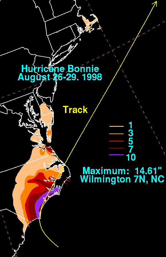
The storm accelerated somewhat by August 26, and early that day, it was moving at about 14 mph (22.5 km/h). An approaching mid-level trough steered Bonnie north-northeast, and at 2100 UTC on August 26, the eye passed east of Cape Fear, North Carolina. The hurricane once again slowed, and early the next day, it made landfall near Wilmington, North Carolina
as a strong Category 2 or weak Category 3 hurricane. Doppler
weather radar
displays estimated that maximum sustained winds had quickly weakened to below hurricane intensity, and the storm was briefly downgraded to a tropical storm. However, as the storm turned towards the east in response to the approaching trough, the center neared open waters and the winds began to re-intensify. As a result, the cyclone re-attained hurricane status at 0000 on August 28. Offshore, the center began drifting roughly eastward. Entering colder waters, hurricane status was lost at 1800 UTC that day, followed by an acceleration to the northeast. The storm began to lose deep thunderstorm activity, and was forecast to lose tropical characteristics and become an extratropical cyclone
within days. By early on August 29, little connection remained over the western semicircle, and only a band of such activity persisted to the southeast of the center. Bonnie became extratropical around 1800 UTC on August 30, to the southeast of Newfoundland.
, Barbuda
, Anguilla
, St. Maarten, Saba and St. Eustatius, though it was discontinued the next day. Shortly thereafter, a tropical storm warning was issued for the U.S. and British Virgin Islands. Tropical storm warnings and hurricane watches were put into effect for the Turks and Caicos Islands
and the southeastern Bahamas. By August 24, those tropical cyclone advisories were discontinued, and at the same time they were issued for parts of the Southeast United States. A hurricane warning was eventually posted for Murrells Inlet, South Carolina
to the North Carolina – Virginia
border. On August 27, tropical cyclone watches and warnings extended as far north as Plymouth, Massachusetts; all were discontinued early on August 29.
 Initially the storm posed a threat to Florida
, where military officials kept abreast of the situation. Heavy surf advisories were posted from central portions of the state northward to Georgia
, and the National Hurricane Center
advised that swimming and boating should be avoided. The Mayport Naval Station ordered 25 ships out to sea in advance of the approaching storm. The Salvation Army
was on standby in Jacksonville
, prepared to act when needed. Hardware stores in the state reported up to a 75% increase in the sales of emergency supplies.
Some computer forecast models initially predicted that the storm would move towards South Carolina or Georgia. Before the storm's arrival in South Carolina
, researchers at Clemson University
used Bonnie to test a new method of estimating the damage a storm is likely to cause. In the state, the South Carolina National Guard put about 1,512 men on active duty, 1,474 being of the Army National Guard. On August 25, the South Carolina Emergency Preparedness Division activated Level 1 operations, the highest of five levels. That same day, the State Governor declared a State of Emergency
, calling for mandatory evacuations of residents east of U.S. Route 17
in Horry
and Georgetown counties. Schools were closed throughout the state. Over 200,000 people were evacuated from those counties, of which 120,000 were tourists. About 6,000 sought shelter at schools in Horry County. In a survey, 12% of respondents in the state took traffic as a significant consideration in deciding if they should evacuate. On the Grand Strand
, Bonnie was the first storm where buses were provided to help people evacuate.
experienced extensive evacuations; at least 300,000 left, bringing traffic on highways from there to the mainland to a standstill. Active duty armed forces were set to support hurricane recovery missions, and four Defense Coordinating officers were notified. Defense Department emergency centers were opened starting August 21. Additionally, the U.S. Atlantic Command activated their 24-hour response cell. Soldiers, sailors, airmen, and Marines evacuated equipment, including hundreds of vessels and aircraft. The North Carolina Department of Environment and Natural Resources
closed several state parks, all three state aquarium
s, and the Division of Marine Fisheries office, with plans to reopen primarily once storm-related damage at any of the locations was properly addressed.
A study was performed on the storm in eight counties in North Carolina to determine the cost of evacuation for hurricanes, and included 1,029 households. Another study was performed regarding the actions taken during Hurricane Bonnie evacuations in the state. Tourists were interviewed, and it was found that 90% of vacationers who were threatened by the hurricane evacuated, of which 56% went home, 3% stayed in public shelters, 22% stayed with friends or relatives, 3% stayed in hotels and motels, and 16% stayed elsewhere. In total, 58% stayed within North Carolina, 12% went to Virginia, 6% relocated to South Carolina, and 24% stayed in other regions. Most of the evacuees left on August 25; 80% left with their own vehicles, and 18% used rental transportation. Officials in the state opened an estimated 100 shelters to accommodate the evacuating tourists and residents.
In Virginia, where 15 jurisdictions declared local emergencies, local governments took action to inform and protect citizens. Residents in mobile home
parks, as well as campgrounds, were advised to evacuate, and 13 jurisdictions opened shelters by August 26. State Governor Jim Gilmore
declared a State of Emergency, and as a result, the State Emergency Operations Center was activated. Beaches and piers were shut down in Virginia Beach
, Hampton
, and Gloucester
counties, where communities canceled some local events due to the threat of Bonnie. Voluntary evacuations throughout the state were issued, and some hotels reached maximum capacity as a result. Roughly 60 Navy ships were ordered to leave port at Norfolk, and ride out the storm far out to sea. The State of Virginia banned swimming along the coast. As Bonnie progressed northward, a tornado watch
was posted for much of eastern Virginia.
 While located north of the Caribbean Sea
, Bonnie dropped light rainfall in Puerto Rico
. The storm also produced heavy rainfall and gusty winds in The Bahamas
, though no significant damage was reported. Along the U.S. East Coast, two swimmers drowned in rip currents; numerous others were rescued. In the United States, Bonnie caused an estimated $1 billion in damage.
was around 2 to 3 ft (0.6096 to 0.9144 m). The highest recorded wind gust in the state was 82 mph (132 km/h) at the Cherry Grove pier, and sustained winds peaked at 76 mph (122.3 km/h) at the Myrtle Beach Pavilion. Damage was widespread in Horry County
, where downed trees and power lines and structural damage was reported. The high winds blew down several trees in Charleston County
, and tore the roof off a strip mall
in North Myrtle Beach
. A 50 year-old man died near Myrtle Beach
; he was electrocuted while checking his generator after a power outage. Along the coast, a 25 year-old man died in rip currents at Surfside Beach
. Total damage in South Carolina was estimated to be around $25 million (1998 USD).
, where gusts reached 63 mph (101.4 km/h). Rainfall was heavy as a result of the storm's slow movement, peaking at 11 in (279.4 mm) at Jacksonville
, while several totals of over 10 in (254 mm) were reported. However, because the area had been experiencing drought
conditions, the flooding was not as severe as it could have potentially been. The most significant flooding occurred near the Cape Fear River
, where high waters were reported. The highest storm surge
occurred along the beaches of Brunswick County
, mostly reaching 5 to 8 ft (1.5 to 2.4 m) above average. Elsewhere, flooding was mostly limited to locations with poor drainage and low-lying areas. Coastal flooding was not widespread, though surge in the Pungo River
flooded several local homes. Other coastal flooding was reported in various harbors and coastal cities. Part of North Carolina Highway 12 was flooded and closed on Hatteras Island
due to tidal flooding. At North Topsail Beach
, many of the protective dunes constructed after Hurricane Fran
in 1996
were destroyed, and along the Bogue Banks
, tens of thousands of tires, part of an artificial reef
, were washed ashore.
 One direct death occurred in North Carolina; a young girl was killed when a tree fell on her Currituck County
home. Throughout eastern portions of the state, trees and powerlines were downed, and there were reports of structural damage. Numerous docks
, pier
s and bulkhead
s were either damaged or destroyed, including the Iron Steamer and Indian Beach piers, which both lost large sections to the strong wind and surf. Due to the winds, the Brunswick Community Hospital lost about 3000 sq ft (278.7 m²). of roof and an air conditioner. The storm left about 500,000 people in the state without electric power. In some areas, vegetative and structural debris accumulated in piles several feet deep; it is reported that thick underbrush prevented the debris from traveling further inland. Wilmington "turned into a disaster zone", with flooded highways, and downed trees laying across roadways. Crop, particularly tobacco
, damage was extensive. According to then-governor Jim Hunt
, "You fly along and don't see much damage to the beach houses, and it's easy to think we didn't have much damage. But then you look at the tobacco in fields and you know the damage has been extensive." The crop losses accounted for much of the overall damage. Forty-seven of those who failed to evacuate in time sought shelter in the Bald Head Island lighthouse as the worst of the storm bore down. Despite the effects, Bonnie's impact was actually less than originally predicted. Overall, property damage in the state is estimated at $240 million (1998 USD), with significantly higher crop damages.
Several locations received significant physical impacts. On Wrightsville Beach, North Carolina
, Bonnie's erosion caused an inlet to migrate further south. On the northern end of the inlet, a large sand bar developed, partially due to the storm moving offshore sand. Dune sediments were lost during the storm, exposing boardwalk piling. Similarly, on Topsail Beach, North Carolina
, the storm breached 27 sand dunes, destroying 60% of the dune line. Sediment from storm washover measured 50 cm (19.7 in) thick behind the beach. Sections of many eroded dunes were re-built using truck loads of sand. Strong waves ran through the foundation of two stilted homes, both of which were later reinforced to compensate for the lost sand.
Bonnie passed just offshore of southeast Virginia, lashing the region with heavy rain and high winds. Sustained winds reached 81 mph (130.4 km/h) at Cape Henry, and gusts peaked at 104 mph (167.4 km/h). There were other reports of winds over 80 mph (128.7 km/h) along the coast. Numerous homes suffered damage in the Hampton Roads area, and near Virginia Beach
, winds blew windows out in hotels. Storm surge was generally around 2 to 4 ft (0.6096 to 1.2 m) with some higher reports, causing some coastal flooding. Rainfall was moderate to heavy, ranging from 1 to 7 in (25.4 to 177.8 mm), with the higher-end totals occurring in the Norfolk area.
Between 320,000 and 650,000 customers lost power in the state. The power outages led to decreased production in some water and sewer plants, prompting local officials to advise residents to conserve water. In the Ocean View section of Norfolk, the winds tore the roofs off two apartment complexes, and damaged siding on other structures. Along the coast, boats were ripped from their moorings.
Throughout the Tidewater region, there were estimates of thousands of downed trees, and hundreds of homes and businesses were damaged. Of these, about 40 structures were declared uninhabitable. Debris was blown several blocks inland from the coast. Among the hardest hit locations was Sandbridge, where about 12 homes were severely damaged. It is reported that the state was unprepared for the damage, expecting a strike from a weakened tropical storm. About $15.3 million (1998 USD) in damage was inflicted in the Virginia Beach and Norfolk areas. Throughout the state, insured losses totaled $95 million (1998 USD).
coast with gusts of up to 42 mph (67.6 km/h) at Ocean City
, and waves of 10 ft (3 m). No damage was reported. Light rainfall was also reported northward into Delaware
and New Jersey
. In addition, up to 0.2 in (5.1 mm) of precipitation extended into New York
. A person was caught in rip currents and drowned near Rehoboth Beach, Delaware
. Along the coast of New Jersey, Bonnie produced strong waves and rip currents, resulting in hundreds of water rescues and eight injuries. The storm was at its closest position to the state on August 28, as it passed 140 mi (225.3 km) to the east of Atlantic City, although the rough surf began several days prior, on August 23. Numerous beaches were closed, and swimming was banned in several communities, as well. The state also reported moderate wind gusts, generally peaking at 35 mph (56.3 km/h). Only minor beach erosion occurred. At Point Pleasant Beach, New Jersey
, there were reports of a drowning in the rough seas caused by the storm; however, the man was later spotted onshore with his fiance, and the two were charged with filing a false police report.
Bonnie moved well to the south of Cape Cod
, although a significant outer rain band affected southern Plymouth County, Massachusetts
. Torrential downpours produced 4 in (101.6 mm) of precipitation at Whitehorse Beach, and other locations reported over 1 in (25 mm). Winds reached 25 to 35 mph (40.2 to 56.3 km/h), although offshore the Georges Bank Buoy reported a 52 mph (83.7 km/h) gust. A man was killed when his rowboat capsized in rough surf of 1 to 2 ft (0.3048 to 0.6096 m); his companion safely swam to shore.
On the afternoon of August 29, Bonnie entered the Canadian Hurricane Centre
's area of responsibility
as a tropical storm, and passed south of Nova Scotia
and Newfoundland
. Precipitation along the coast of Nova Scotia ranged from 15 to 25 mm (0.590551181102362 to 0.984251968503937 in) and winds gusted to around 102 km/h (63.4 mph). Slightly higher gusts were reported off the coast. On Sable Island
, the storm dropped 30 mm (1.2 in) of rainfall. An offshore buoy recorded a wave height of 17.9 m (58.7 ft).
 Following the hurricane in North Carolina, 10 counties were declared federal disaster areas, while 30 counties became eligible for public and individual assistance. Shelters were opened in 11 counties, and the Raleigh-Durham International Airport
briefly canceled all flights. To remove the tens of thousands of tires that washed ashore, hundreds of inmates
from state prisons were sent to the Bouge Banks. Some of the tires were buried in sand, and could only be removed during low tide. About 700 more state prisoners were sent around the state to clear debris, and 39 inmate crews were deployed to help farmers salvage the severely damaged tobacco fields. In South Carolina, Horry County was declared a federal disaster area due to the damage. In Virginia, the cities of Chesapeake, Norfolk, Portsmouth, Suffolk, and Virginia Beach became eligible for individual and public assistance programs. After the storm's departure, a thunderstorm temporarily halted power restoration by Virginia Power company crews. Virginia Governor Jim Gilmore
allowed for over $11 million (1998 USD) in state and federal funds to help five cities recover. The storm also contributed to a 13.6% decline in home sales across the southern United States during the month of August by "discouraging potential home buyers" in coastal areas.
Both during and after Hurricane Bonnie's onslaught, analysis of the storm was extensive; it was deemed "the most observed hurricane in history." When examined with Tropical Rainfall Measuring Mission
(TRMM) satellite imagery, it was discovered that peak cloud tops surrounding the eyewall rose 59000 ft (17,983.2 m) into the atmosphere, twice as tall as Mount Everest
. This was the first time that TRMM had observed such a tropical cyclone structure, according to co-developer of the Saffir-Simpson Hurricane Scale
, Bob Simpson. The storm was also used for collection of tropical cyclone research data. For the first time in the Atlantic, a fleet of aircraft investigated the storm's upper-levels, while other aircraft flew into the low- and middle-levels. A record of over 500 parachute sensors were dropped into the storm while it was active. Each costing $600 (1998 USD), they sent storm data to research centers via Global Positioning System
.
During the storm, the Weather Channel web site experienced substantially increased traffic. Up from an average of three million views per day, 10 million page views on August 26 led to slow download times on the website. On seven major weather providers, page views increased by 123% from August 24 – August 26, compared to an equal period of time during the previous week.
North Carolina
North Carolina is a state located in the southeastern United States. The state borders South Carolina and Georgia to the south, Tennessee to the west and Virginia to the north. North Carolina contains 100 counties. Its capital is Raleigh, and its largest city is Charlotte...
, United States
United States
The United States of America is a federal constitutional republic comprising fifty states and a federal district...
, inflicting severe crop damage. The second named storm, first hurricane, and first major hurricane of the 1998 Atlantic hurricane season
1998 Atlantic hurricane season
The 1998 Atlantic hurricane season officially began on June 1, 1998, and lasted until November 30, 1998. These dates conventionally delimit the period of each year when most tropical cyclones form in the Atlantic basin; however, the season extended through December 1 as Hurricane Nicole remained...
, Bonnie developed from a tropical wave
Tropical wave
Tropical waves, easterly waves, or tropical easterly waves, also known as African easterly waves in the Atlantic region, are a type of atmospheric trough, an elongated area of relatively low air pressure, oriented north to south, which move from east to west across the tropics causing areas of...
that emerged off the coast of Africa
Africa
Africa is the world's second largest and second most populous continent, after Asia. At about 30.2 million km² including adjacent islands, it covers 6% of the Earth's total surface area and 20.4% of the total land area...
on August 14. The wave gradually developed, and the system was designated a tropical depression on August 19. The depression began tracking towards the west-northwest, and became a tropical storm the next day. On August 22, Bonnie was upgraded to a hurricane, with a well-defined eye
Eye (cyclone)
The eye is a region of mostly calm weather found at the center of strong tropical cyclones. The eye of a storm is a roughly circular area and typically 30–65 km in diameter. It is surrounded by the eyewall, a ring of towering thunderstorms where the second most severe weather of a cyclone...
. The storm peaked as a Category 3 hurricane on the Saffir-Simpson Hurricane Scale
Saffir-Simpson Hurricane Scale
The Saffir–Simpson Hurricane Scale , or the Saffir–Simpson Hurricane Wind Scale , classifies hurricanes — Western Hemisphere tropical cyclones that exceed the intensities of tropical depressions and tropical storms — into five categories distinguished by the intensities of their sustained winds...
, and around the same time, the storm slowed and turned more towards the north-northwest. A large and powerful cyclone, Bonnie moved ashore in North Carolina
North Carolina
North Carolina is a state located in the southeastern United States. The state borders South Carolina and Georgia to the south, Tennessee to the west and Virginia to the north. North Carolina contains 100 counties. Its capital is Raleigh, and its largest city is Charlotte...
early on August 27, slowing as it turned northeast. After briefly losing hurricane status, the storm moved offshore and regained Category 1-force winds, although it weakened again on entering cooler waters.
Fearing a major hurricane strike, coastal locations from Florida
Florida
Florida is a state in the southeastern United States, located on the nation's Atlantic and Gulf coasts. It is bordered to the west by the Gulf of Mexico, to the north by Alabama and Georgia and to the east by the Atlantic Ocean. With a population of 18,801,310 as measured by the 2010 census, it...
to Virginia
Virginia
The Commonwealth of Virginia , is a U.S. state on the Atlantic Coast of the Southern United States. Virginia is nicknamed the "Old Dominion" and sometimes the "Mother of Presidents" after the eight U.S. presidents born there...
performed extensive preparations in advance of the storm. In addition to tropical cyclone watches and warnings, about 950,000 people were evacuated from the Carolinas, and the military evacuated and relocated hundreds of aircraft and vessels from the storm's projected path. Soldiers and guardsmen were deployed throughout those regions.
Hurricane Bonnie made landfall as a borderline Category 2–Category 3 storm, with intense wind gusts of up to 104 mph (167.4 km/h) and rainfall peaking at about 11 in (279.4 mm). Reports of downed trees and powerlines, as well as structural damage such as blown-out windows and torn-off roofs, were reported. In coastal North Carolina, the storm washed ashore tens of thousands of tires that had been part of an artificial reef. Crop damage was extensive, but the storm was overall less severe than initially feared. Total damage was estimated at $1 billion (1998 USD).
Meteorological history
On August 14, 1998, a tropical waveTropical wave
Tropical waves, easterly waves, or tropical easterly waves, also known as African easterly waves in the Atlantic region, are a type of atmospheric trough, an elongated area of relatively low air pressure, oriented north to south, which move from east to west across the tropics causing areas of...
emerged off the west coast of Africa
Africa
Africa is the world's second largest and second most populous continent, after Asia. At about 30.2 million km² including adjacent islands, it covers 6% of the Earth's total surface area and 20.4% of the total land area...
just north of Dakar
Dakar
Dakar is the capital city and largest city of Senegal. It is located on the Cap-Vert Peninsula on the Atlantic coast and is the westernmost city on the African mainland...
and moved westward across the Atlantic Ocean
Atlantic Ocean
The Atlantic Ocean is the second-largest of the world's oceanic divisions. With a total area of about , it covers approximately 20% of the Earth's surface and about 26% of its water surface area...
. Initially located within cool waters, a strong high pressure area
High pressure area
A high-pressure area is a region where the atmospheric pressure at the surface of the planet is greater than its surrounding environment. Winds within high-pressure areas flow outward due to the higher density air near their center and friction with land...
steered the disturbance on a west–southwest track over warmer waters, and convection
Atmospheric convection
Atmospheric convection is the result of a parcel-environment instability, or temperature difference, layer in the atmosphere. Different lapse rates within dry and moist air lead to instability. Mixing of air during the day which expands the height of the planetary boundary layer leads to...
started to develop. Several small centers of rotation existed within a broad circulation, and at 1200 UTC on August 19, the centers consolidated and the disturbance became sufficiently organized to be declared a tropical depression. Despite being poorly organized, winds slightly to the north of the system's center approached tropical storm strength shortly thereafter. Ship reports revealed a closed circulation, though the center was elongated in a northwest–southeast oriented manner. Upper-level winds were favorable, which suggested that intensification was likely. The cyclone began moving on a northwestward track, and just hours later the center of circulation appeared to reform close to the convection, an indication of a strengthening storm, as good outflow existed over the western side of the storm. Deep convection slowly developed closer to the center, and at 1200 UTC on August 20, the depression was upgraded into Tropical Storm Bonnie as it continued its west–northwest track around the periphery of a high pressure system over the Leeward Islands
Leeward Islands
The Leeward Islands are a group of islands in the West Indies. They are the northern islands of the Lesser Antilles chain. As a group they start east of Puerto Rico and reach southward to Dominica. They are situated where the northeastern Caribbean Sea meets the western Atlantic Ocean...
.
Late on August 20, the first reconnaissance plane entered the storm and found a minimum central barometric pressure of 1001 mb. The storm brushed the Leeward Islands, although the main thunderstorm activity remained to the north of the storm over the open ocean. Bonnie began to organize its broad circulation early on August 21, and within the next day the storm began to intensify. The storm began to look strong on satellite images with banding features over the north and west quadrants. The Hurricane Hunters
Hurricane Hunters
The Hurricane Hunters are aircraft that fly into tropical cyclones in the North Atlantic Ocean and Northeastern Pacific Ocean for the specific purpose of directly measuring weather data in and around those storms. In the United States, the Air Force, Navy, and NOAA units have all participated in...
aircraft found a minimum pressure of 987 mb and a nearly complete eyewall
Eye (cyclone)
The eye is a region of mostly calm weather found at the center of strong tropical cyclones. The eye of a storm is a roughly circular area and typically 30–65 km in diameter. It is surrounded by the eyewall, a ring of towering thunderstorms where the second most severe weather of a cyclone...
early on August 22, and as a result, the tropical storm was upgraded to hurricane status. Bonnie slowed in forward speed, coinciding with previous forecasts. Later that day, storm was upgraded to a Category 2 on the Saffir-Simpson Hurricane Scale
Saffir-Simpson Hurricane Scale
The Saffir–Simpson Hurricane Scale , or the Saffir–Simpson Hurricane Wind Scale , classifies hurricanes — Western Hemisphere tropical cyclones that exceed the intensities of tropical depressions and tropical storms — into five categories distinguished by the intensities of their sustained winds...
, which occurred with a substantial 15 mb drop in 8 hours. At the same time, steering currents weakened with the dissipation of the high pressure system; this, combined with the effect of a nearby trough
Trough (meteorology)
A trough is an elongated region of relatively low atmospheric pressure, often associated with fronts.Unlike fronts, there is not a universal symbol for a trough on a weather chart. The weather charts in some countries or regions mark troughs by a line. In the United States, a trough may be marked...
, caused the storm to turn in a more north-northwestward direction around the western periphery of an anticyclone
Anticyclone
An anticyclone is a weather phenomenon defined by the United States' National Weather Service's glossary as "[a] large-scale circulation of winds around a central region of high atmospheric pressure, clockwise in the Northern Hemisphere, counterclockwise in the Southern Hemisphere"...
to the east. Bonnie became a Category 3 storm, a major hurricane, at 1200 UTC the next day, reaching its peak winds of 115 mph (185.1 km/h) at the same time.
National Hurricane Center
The National Hurricane Center , located at Florida International University in Miami, Florida, is the division of the National Weather Service responsible for tracking and predicting weather systems within the tropics between the Prime Meridian and the 140th meridian west poleward to the 30th...
(NHC) advisory then reported that the eye was becoming more distinct and well-defined. This strengthening trend abated because the storm had churned up the waters over which it was passing, bringing cooler water to the surface as a result of the slow track. Another inhibiting factor may have been related to the same trough that caused the northward turn, though due to a large anticyclone situated over the hurricane, the weakening effects were not substantial. Despite wind shear
Wind shear
Wind shear, sometimes referred to as windshear or wind gradient, is a difference in wind speed and direction over a relatively short distance in the atmosphere...
, the large and powerful circulation resisted weakening for a time. Early on August 25, the shear and the entrainment of drier air into the hurricane took its toll on Bonnie, giving it a ragged appearance on satellite imagery, and the eye briefly became cloud-filled.
The storm accelerated somewhat by August 26, and early that day, it was moving at about 14 mph (22.5 km/h). An approaching mid-level trough steered Bonnie north-northeast, and at 2100 UTC on August 26, the eye passed east of Cape Fear, North Carolina. The hurricane once again slowed, and early the next day, it made landfall near Wilmington, North Carolina
Wilmington, North Carolina
Wilmington is a port city in and is the county seat of New Hanover County, North Carolina, United States. The population is 106,476 according to the 2010 Census, making it the eighth most populous city in the state of North Carolina...
as a strong Category 2 or weak Category 3 hurricane. Doppler
Pulse-doppler radar
Pulse-Doppler is a 4D radar system capable of detecting both target 3D location as well as measuring radial velocity . It uses the Doppler effect to avoid overloading computers and operators as well as to reduce power consumption...
weather radar
Weather radar
Weather radar, also called weather surveillance radar and Doppler weather radar, is a type of radar used to locate precipitation, calculate its motion, estimate its type . Modern weather radars are mostly pulse-Doppler radars, capable of detecting the motion of rain droplets in addition to the...
displays estimated that maximum sustained winds had quickly weakened to below hurricane intensity, and the storm was briefly downgraded to a tropical storm. However, as the storm turned towards the east in response to the approaching trough, the center neared open waters and the winds began to re-intensify. As a result, the cyclone re-attained hurricane status at 0000 on August 28. Offshore, the center began drifting roughly eastward. Entering colder waters, hurricane status was lost at 1800 UTC that day, followed by an acceleration to the northeast. The storm began to lose deep thunderstorm activity, and was forecast to lose tropical characteristics and become an extratropical cyclone
Extratropical cyclone
Extratropical cyclones, sometimes called mid-latitude cyclones or wave cyclones, are a group of cyclones defined as synoptic scale low pressure weather systems that occur in the middle latitudes of the Earth having neither tropical nor polar characteristics, and are connected with fronts and...
within days. By early on August 29, little connection remained over the western semicircle, and only a band of such activity persisted to the southeast of the center. Bonnie became extratropical around 1800 UTC on August 30, to the southeast of Newfoundland.
Preparations
On August 20, a tropical storm watch was posted for the islands of AntiguaAntigua
Antigua , also known as Waladli, is an island in the West Indies, in the Leeward Islands in the Caribbean region, the main island of the country of Antigua and Barbuda. Antigua means "ancient" in Spanish and was named by Christopher Columbus after an icon in Seville Cathedral, Santa Maria de la...
, Barbuda
Barbuda
Barbuda is an island in the Eastern Caribbean, and forms part of the state of Antigua and Barbuda. It has a population of about 1,500, most of whom live in the town of Codrington.-Location:...
, Anguilla
Anguilla
Anguilla is a British overseas territory and overseas territory of the European Union in the Caribbean. It is one of the most northerly of the Leeward Islands in the Lesser Antilles, lying east of Puerto Rico and the Virgin Islands and directly north of Saint Martin...
, St. Maarten, Saba and St. Eustatius, though it was discontinued the next day. Shortly thereafter, a tropical storm warning was issued for the U.S. and British Virgin Islands. Tropical storm warnings and hurricane watches were put into effect for the Turks and Caicos Islands
Turks and Caicos Islands
The Turks and Caicos Islands are a British Overseas Territory and overseas territory of the European Union consisting of two groups of tropical islands in the Caribbean, the larger Caicos Islands and the smaller Turks Islands, known for tourism and as an offshore financial centre.The Turks and...
and the southeastern Bahamas. By August 24, those tropical cyclone advisories were discontinued, and at the same time they were issued for parts of the Southeast United States. A hurricane warning was eventually posted for Murrells Inlet, South Carolina
Murrells Inlet, South Carolina
Murrells Inlet is a small fishing village in Horry County, South Carolina, United States that is considered to be the "Seafood Capital of South Carolina". The population was 5,519 at the 2000 census. It was once primarily a fishing village, but has grown substantially in modern time, along with the...
to the North Carolina – Virginia
Virginia
The Commonwealth of Virginia , is a U.S. state on the Atlantic Coast of the Southern United States. Virginia is nicknamed the "Old Dominion" and sometimes the "Mother of Presidents" after the eight U.S. presidents born there...
border. On August 27, tropical cyclone watches and warnings extended as far north as Plymouth, Massachusetts; all were discontinued early on August 29.
Florida and South Carolina
Florida
Florida is a state in the southeastern United States, located on the nation's Atlantic and Gulf coasts. It is bordered to the west by the Gulf of Mexico, to the north by Alabama and Georgia and to the east by the Atlantic Ocean. With a population of 18,801,310 as measured by the 2010 census, it...
, where military officials kept abreast of the situation. Heavy surf advisories were posted from central portions of the state northward to Georgia
Georgia (U.S. state)
Georgia is a state located in the southeastern United States. It was established in 1732, the last of the original Thirteen Colonies. The state is named after King George II of Great Britain. Georgia was the fourth state to ratify the United States Constitution, on January 2, 1788...
, and the National Hurricane Center
National Hurricane Center
The National Hurricane Center , located at Florida International University in Miami, Florida, is the division of the National Weather Service responsible for tracking and predicting weather systems within the tropics between the Prime Meridian and the 140th meridian west poleward to the 30th...
advised that swimming and boating should be avoided. The Mayport Naval Station ordered 25 ships out to sea in advance of the approaching storm. The Salvation Army
Salvation Army
The Salvation Army is a Protestant Christian church known for its thrift stores and charity work. It is an international movement that currently works in over a hundred countries....
was on standby in Jacksonville
Jacksonville, Florida
Jacksonville is the largest city in the U.S. state of Florida in terms of both population and land area, and the largest city by area in the contiguous United States. It is the county seat of Duval County, with which the city government consolidated in 1968...
, prepared to act when needed. Hardware stores in the state reported up to a 75% increase in the sales of emergency supplies.
Some computer forecast models initially predicted that the storm would move towards South Carolina or Georgia. Before the storm's arrival in South Carolina
South Carolina
South Carolina is a state in the Deep South of the United States that borders Georgia to the south, North Carolina to the north, and the Atlantic Ocean to the east. Originally part of the Province of Carolina, the Province of South Carolina was one of the 13 colonies that declared independence...
, researchers at Clemson University
Clemson University
Clemson University is an American public, coeducational, land-grant, sea-grant, research university located in Clemson, South Carolina, United States....
used Bonnie to test a new method of estimating the damage a storm is likely to cause. In the state, the South Carolina National Guard put about 1,512 men on active duty, 1,474 being of the Army National Guard. On August 25, the South Carolina Emergency Preparedness Division activated Level 1 operations, the highest of five levels. That same day, the State Governor declared a State of Emergency
State of emergency
A state of emergency is a governmental declaration that may suspend some normal functions of the executive, legislative and judicial powers, alert citizens to change their normal behaviours, or order government agencies to implement emergency preparedness plans. It can also be used as a rationale...
, calling for mandatory evacuations of residents east of U.S. Route 17
U.S. Route 17
U.S. Route 17 or U.S. Highway 17 is a north–south United States highway. The highway spans the southeastern United States and is close to the Atlantic Coast for much of its length. The highway's southern terminus is at Punta Gorda, Florida, at an intersection with U.S. Route 41...
in Horry
Horry County, South Carolina
Horry County is a county located in the U.S. state of South Carolina. This name honored Revolutionary War Hero, Peter Horry. Brigadier General Horry was born in South Carolina sometime around 1743 and started his distinguished military career in 1775 as one of 20 captains the Provincial Congress...
and Georgetown counties. Schools were closed throughout the state. Over 200,000 people were evacuated from those counties, of which 120,000 were tourists. About 6,000 sought shelter at schools in Horry County. In a survey, 12% of respondents in the state took traffic as a significant consideration in deciding if they should evacuate. On the Grand Strand
Grand Strand
The Grand Strand refers to a large stretch of beaches on the East Coast of the United States extending from Little River to Georgetown in the U.S. State of South Carolina. It consists of 60+ miles along an essentially uninterrupted arc of beach land, beginning around the Little River and...
, Bonnie was the first storm where buses were provided to help people evacuate.
North Carolina and Virginia
About 815 guardsmen were called to North Carolina, where they assisted local authorities with the extensive preparations, including evacuating 750,000 state citizens. Mandatory and voluntary evacuations were ordered for part of the state. The Outer BanksOuter Banks
The Outer Banks is a 200-mile long string of narrow barrier islands off the coast of North Carolina, beginning in the southeastern corner of Virginia Beach on the east coast of the United States....
experienced extensive evacuations; at least 300,000 left, bringing traffic on highways from there to the mainland to a standstill. Active duty armed forces were set to support hurricane recovery missions, and four Defense Coordinating officers were notified. Defense Department emergency centers were opened starting August 21. Additionally, the U.S. Atlantic Command activated their 24-hour response cell. Soldiers, sailors, airmen, and Marines evacuated equipment, including hundreds of vessels and aircraft. The North Carolina Department of Environment and Natural Resources
North Carolina Department of Environment and Natural Resources
The North Carolina Department of Environment and Natural Resources is the state's leading stewardship agency for the preservation and protection of natural resources and public health.- Divisions :* Air Quality* Aquariums...
closed several state parks, all three state aquarium
Aquarium
An aquarium is a vivarium consisting of at least one transparent side in which water-dwelling plants or animals are kept. Fishkeepers use aquaria to keep fish, invertebrates, amphibians, marine mammals, turtles, and aquatic plants...
s, and the Division of Marine Fisheries office, with plans to reopen primarily once storm-related damage at any of the locations was properly addressed.
A study was performed on the storm in eight counties in North Carolina to determine the cost of evacuation for hurricanes, and included 1,029 households. Another study was performed regarding the actions taken during Hurricane Bonnie evacuations in the state. Tourists were interviewed, and it was found that 90% of vacationers who were threatened by the hurricane evacuated, of which 56% went home, 3% stayed in public shelters, 22% stayed with friends or relatives, 3% stayed in hotels and motels, and 16% stayed elsewhere. In total, 58% stayed within North Carolina, 12% went to Virginia, 6% relocated to South Carolina, and 24% stayed in other regions. Most of the evacuees left on August 25; 80% left with their own vehicles, and 18% used rental transportation. Officials in the state opened an estimated 100 shelters to accommodate the evacuating tourists and residents.
In Virginia, where 15 jurisdictions declared local emergencies, local governments took action to inform and protect citizens. Residents in mobile home
Mobile home
Mobile homes or static caravans are prefabricated homes built in factories, rather than on site, and then taken to the place where they will be occupied...
parks, as well as campgrounds, were advised to evacuate, and 13 jurisdictions opened shelters by August 26. State Governor Jim Gilmore
Jim Gilmore
James Stuart "Jim" Gilmore III is an American politician from the Commonwealth of Virginia, former 68th Governor of Virginia, and a member of the Republican Party. A native Virginian, Gilmore studied at the University of Virginia, and then served in the U.S. Army as a counterintelligence agent...
declared a State of Emergency, and as a result, the State Emergency Operations Center was activated. Beaches and piers were shut down in Virginia Beach
Virginia Beach, Virginia
Virginia Beach is an independent city located in the Hampton Roads metropolitan area of Virginia, on the Atlantic Ocean at the mouth of the Chesapeake Bay...
, Hampton
Hampton, Virginia
Hampton is an independent city that is not part of any county in Southeast Virginia. Its population is 137,436. As one of the seven major cities that compose the Hampton Roads metropolitan area, it is on the southeastern end of the Virginia Peninsula. Located on the Hampton Roads Beltway, it hosts...
, and Gloucester
Gloucester County, Virginia
Gloucester County is within the Commonwealth of Virginia in the Hampton Roads metropolitan area in the USA. Formed in 1651 in the Virginia Colony, the county was named for Henry Stuart, Duke of Gloucester, third son of King Charles I of Great Britain. Located in the Middle Peninsula region, it...
counties, where communities canceled some local events due to the threat of Bonnie. Voluntary evacuations throughout the state were issued, and some hotels reached maximum capacity as a result. Roughly 60 Navy ships were ordered to leave port at Norfolk, and ride out the storm far out to sea. The State of Virginia banned swimming along the coast. As Bonnie progressed northward, a tornado watch
Tornado watch
A tornado watch is issued when conditions are right for a tornado to form. Since any thunderstorm capable of producing a tornado is defined as severe, a tornado watch is also automatically a severe thunderstorm watch...
was posted for much of eastern Virginia.
Impact
Caribbean Sea
The Caribbean Sea is a sea of the Atlantic Ocean located in the tropics of the Western hemisphere. It is bounded by Mexico and Central America to the west and southwest, to the north by the Greater Antilles, and to the east by the Lesser Antilles....
, Bonnie dropped light rainfall in Puerto Rico
Puerto Rico
Puerto Rico , officially the Commonwealth of Puerto Rico , is an unincorporated territory of the United States, located in the northeastern Caribbean, east of the Dominican Republic and west of both the United States Virgin Islands and the British Virgin Islands.Puerto Rico comprises an...
. The storm also produced heavy rainfall and gusty winds in The Bahamas
The Bahamas
The Bahamas , officially the Commonwealth of the Bahamas, is a nation consisting of 29 islands, 661 cays, and 2,387 islets . It is located in the Atlantic Ocean north of Cuba and Hispaniola , northwest of the Turks and Caicos Islands, and southeast of the United States...
, though no significant damage was reported. Along the U.S. East Coast, two swimmers drowned in rip currents; numerous others were rescued. In the United States, Bonnie caused an estimated $1 billion in damage.
South Carolina
As the hurricane passed to the east of the state, rainfall ranged from 2 to 4 in (50.8 to 101.6 mm), and storm surgeStorm surge
A storm surge is an offshore rise of water associated with a low pressure weather system, typically tropical cyclones and strong extratropical cyclones. Storm surges are caused primarily by high winds pushing on the ocean's surface. The wind causes the water to pile up higher than the ordinary sea...
was around 2 to 3 ft (0.6096 to 0.9144 m). The highest recorded wind gust in the state was 82 mph (132 km/h) at the Cherry Grove pier, and sustained winds peaked at 76 mph (122.3 km/h) at the Myrtle Beach Pavilion. Damage was widespread in Horry County
Horry County, South Carolina
Horry County is a county located in the U.S. state of South Carolina. This name honored Revolutionary War Hero, Peter Horry. Brigadier General Horry was born in South Carolina sometime around 1743 and started his distinguished military career in 1775 as one of 20 captains the Provincial Congress...
, where downed trees and power lines and structural damage was reported. The high winds blew down several trees in Charleston County
Charleston County, South Carolina
Charleston County is a county located in the U.S. state of South Carolina. According to a 2005 U.S. Census Bureau estimate, its population was 330,368. Its county seat is Charleston. It is the third-most populous county in the state . Charleston County was created in 1901 by an act of the South...
, and tore the roof off a strip mall
Strip mall
A strip mall is an open-area shopping center where the stores are arranged in a row, with a sidewalk in front. Strip malls are typically developed as a unit and have large parking lots in front...
in North Myrtle Beach
North Myrtle Beach, South Carolina
North Myrtle Beach is a coastal resort city in Horry County, South Carolina, United States. It was created in 1968 from four existing municipalities north of Myrtle Beach, and serves as one of the primary tourist towns along the Grand Strand...
. A 50 year-old man died near Myrtle Beach
Myrtle Beach, South Carolina
Myrtle Beach is a coastal city on the east coast of the United States in Horry County, South Carolina. It is situated on the center of a large and continuous stretch of beach known as the Grand Strand in northeastern South Carolina. It is considered to be a major tourist destination in the...
; he was electrocuted while checking his generator after a power outage. Along the coast, a 25 year-old man died in rip currents at Surfside Beach
Surfside Beach, South Carolina
Surfside Beach is a small seaside town in Horry County, South Carolina, United States situated directly south of Myrtle Beach, South Carolina. Its nickname is "The Family Beach". The population was 4,425 at the 2000 census...
. Total damage in South Carolina was estimated to be around $25 million (1998 USD).
North Carolina
Hurricane Bonnie came ashore just at or below major hurricane intensity, bringing with it intense wind gusts of up to 98 mph (157.7 km/h) in North Carolina, though offshore at the Frying Pan Shoals Light Tower, winds reached 104 mph (167.4 km/h). The strongest winds were found in the precursor rainbands, where localized downbursts caused severe damage. Sustained winds officially peaked at 51 mph (82.1 km/h) at Elizabeth CityElizabeth City, North Carolina
Elizabeth City is a city in Pasquotank County and Camden County in the State of North Carolina. With a population of 18,683 at the 2010 census, Elizabeth City is the county seat of Pasquotank County....
, where gusts reached 63 mph (101.4 km/h). Rainfall was heavy as a result of the storm's slow movement, peaking at 11 in (279.4 mm) at Jacksonville
Jacksonville, North Carolina
Jacksonville, North Carolina, is a city in Onslow County, North Carolina, United States. As of the 2010 United States census, the population stood at 70,145, which makes Jacksonville the 14th largest city in North Carolina...
, while several totals of over 10 in (254 mm) were reported. However, because the area had been experiencing drought
Drought
A drought is an extended period of months or years when a region notes a deficiency in its water supply. Generally, this occurs when a region receives consistently below average precipitation. It can have a substantial impact on the ecosystem and agriculture of the affected region...
conditions, the flooding was not as severe as it could have potentially been. The most significant flooding occurred near the Cape Fear River
Cape Fear River
The Cape Fear River is a long blackwater river in east central North Carolina in the United States. It flows into the Atlantic Ocean near Cape Fear, from which it takes its name. The overall water quality of the river is continuously measured and monitored by and conducted by the , , and the...
, where high waters were reported. The highest storm surge
Storm surge
A storm surge is an offshore rise of water associated with a low pressure weather system, typically tropical cyclones and strong extratropical cyclones. Storm surges are caused primarily by high winds pushing on the ocean's surface. The wind causes the water to pile up higher than the ordinary sea...
occurred along the beaches of Brunswick County
Brunswick County, North Carolina
-External links:*******....
, mostly reaching 5 to 8 ft (1.5 to 2.4 m) above average. Elsewhere, flooding was mostly limited to locations with poor drainage and low-lying areas. Coastal flooding was not widespread, though surge in the Pungo River
Pungo River
The Pungo River is a river in eastern North Carolina, USA. It originally began in the Great Dismal Swamp in Washington County, North Carolina; the upper part of the river has since been supplanted by the Pungo River Canal, dug in the 1950s to improve drainage of local farmland. The river flows...
flooded several local homes. Other coastal flooding was reported in various harbors and coastal cities. Part of North Carolina Highway 12 was flooded and closed on Hatteras Island
Hatteras Island
Hatteras Island is a barrier island located off the North Carolina coast. Dividing the Atlantic Ocean and the Pamlico Sound, it runs parallel to the coast, forming a bend at Cape Hatteras. It is part of North Carolina's Outer Banks and includes the towns of Rodanthe, Waves, Salvo, Avon, Buxton,...
due to tidal flooding. At North Topsail Beach
North Topsail Beach, North Carolina
North Topsail Beach is a town in Onslow County, North Carolina, United States. The 2008 estimated population was 955. It is located on Topsail Island.North Topsail Beach is part of the Jacksonville, North Carolina Metropolitan Statistical Area.-Geography:...
, many of the protective dunes constructed after Hurricane Fran
Hurricane Fran
Hurricane Fran was a powerful Cape Verde-type hurricane of the 1996 Atlantic hurricane season that made landfall near Cape Fear in North Carolina at Category 3 strength. Throughout the eastern United States, early statistics on Fran reported 27 deaths and $3.2 billion in damage...
in 1996
1996 Atlantic hurricane season
The 1996 Atlantic hurricane season was the first season since 1965 in which all tropical cyclones reached tropical storm status. It officially began on June 1, 1996, and lasted until November 30, 1996...
were destroyed, and along the Bogue Banks
Bogue Banks
Bogue Banks form a barrier island off the mainland of North Carolina in Carteret County. The island, separated from the mainland by Bogue Sound, runs east to west, with the ocean beaches facing due south...
, tens of thousands of tires, part of an artificial reef
Reef
In nautical terminology, a reef is a rock, sandbar, or other feature lying beneath the surface of the water ....
, were washed ashore.
Currituck County, North Carolina
-National protected areas:*Currituck National Wildlife Refuge*Mackay Island National Wildlife Refuge -Demographics:As of the census of 2010, there were 23,547 people, 6,902 households, and 5,204 families residing in the county. The population density was 70 people per square mile . There were...
home. Throughout eastern portions of the state, trees and powerlines were downed, and there were reports of structural damage. Numerous docks
Dock (maritime)
A dock is a human-made structure or group of structures involved in the handling of boats or ships, usually on or close to a shore.However, the exact meaning varies among different variants of the English language...
, pier
Pier
A pier is a raised structure, including bridge and building supports and walkways, over water, typically supported by widely spread piles or pillars...
s and bulkhead
Bulkhead
Bulkhead may refer to:* Bulkhead, a compartment of a building for preventing spread of fires, see Compartmentalization * Bulkhead , a retaining wall used as a form of coastal management, akin to a seawall, or as a structural device such as a bulkhead partition* Bulkhead , a wall within the hull of...
s were either damaged or destroyed, including the Iron Steamer and Indian Beach piers, which both lost large sections to the strong wind and surf. Due to the winds, the Brunswick Community Hospital lost about 3000 sq ft (278.7 m²). of roof and an air conditioner. The storm left about 500,000 people in the state without electric power. In some areas, vegetative and structural debris accumulated in piles several feet deep; it is reported that thick underbrush prevented the debris from traveling further inland. Wilmington "turned into a disaster zone", with flooded highways, and downed trees laying across roadways. Crop, particularly tobacco
Tobacco
Tobacco is an agricultural product processed from the leaves of plants in the genus Nicotiana. It can be consumed, used as a pesticide and, in the form of nicotine tartrate, used in some medicines...
, damage was extensive. According to then-governor Jim Hunt
Jim Hunt
James Baxter Hunt Jr. is an American politician who was the 69th and 71st Governor of the state of North Carolina . He is the longest-serving governor in the state's history.-Early life:...
, "You fly along and don't see much damage to the beach houses, and it's easy to think we didn't have much damage. But then you look at the tobacco in fields and you know the damage has been extensive." The crop losses accounted for much of the overall damage. Forty-seven of those who failed to evacuate in time sought shelter in the Bald Head Island lighthouse as the worst of the storm bore down. Despite the effects, Bonnie's impact was actually less than originally predicted. Overall, property damage in the state is estimated at $240 million (1998 USD), with significantly higher crop damages.
Several locations received significant physical impacts. On Wrightsville Beach, North Carolina
Wrightsville Beach, North Carolina
Wrightsville Beach is a town in New Hanover County, North Carolina, United States. Wrightsville Beach is just east of Wilmington and is part of the Wilmington Metropolitan Statistical Area. The population was 2,593 at the 2000 census...
, Bonnie's erosion caused an inlet to migrate further south. On the northern end of the inlet, a large sand bar developed, partially due to the storm moving offshore sand. Dune sediments were lost during the storm, exposing boardwalk piling. Similarly, on Topsail Beach, North Carolina
Topsail Beach, North Carolina
Topsail Beach is a town in Pender County, North Carolina, United States. The population was 581 at the 2008 census. It is part of the Wilmington Metropolitan Statistical Area.-Geography:Topsail Beach is located at ....
, the storm breached 27 sand dunes, destroying 60% of the dune line. Sediment from storm washover measured 50 cm (19.7 in) thick behind the beach. Sections of many eroded dunes were re-built using truck loads of sand. Strong waves ran through the foundation of two stilted homes, both of which were later reinforced to compensate for the lost sand.
Virginia
Bonnie passed just offshore of southeast Virginia, lashing the region with heavy rain and high winds. Sustained winds reached 81 mph (130.4 km/h) at Cape Henry, and gusts peaked at 104 mph (167.4 km/h). There were other reports of winds over 80 mph (128.7 km/h) along the coast. Numerous homes suffered damage in the Hampton Roads area, and near Virginia Beach
Virginia Beach, Virginia
Virginia Beach is an independent city located in the Hampton Roads metropolitan area of Virginia, on the Atlantic Ocean at the mouth of the Chesapeake Bay...
, winds blew windows out in hotels. Storm surge was generally around 2 to 4 ft (0.6096 to 1.2 m) with some higher reports, causing some coastal flooding. Rainfall was moderate to heavy, ranging from 1 to 7 in (25.4 to 177.8 mm), with the higher-end totals occurring in the Norfolk area.
Between 320,000 and 650,000 customers lost power in the state. The power outages led to decreased production in some water and sewer plants, prompting local officials to advise residents to conserve water. In the Ocean View section of Norfolk, the winds tore the roofs off two apartment complexes, and damaged siding on other structures. Along the coast, boats were ripped from their moorings.
Throughout the Tidewater region, there were estimates of thousands of downed trees, and hundreds of homes and businesses were damaged. Of these, about 40 structures were declared uninhabitable. Debris was blown several blocks inland from the coast. Among the hardest hit locations was Sandbridge, where about 12 homes were severely damaged. It is reported that the state was unprepared for the damage, expecting a strike from a weakened tropical storm. About $15.3 million (1998 USD) in damage was inflicted in the Virginia Beach and Norfolk areas. Throughout the state, insured losses totaled $95 million (1998 USD).
Mid-Atlantic, New England and Atlantic Canada
As the storm moved offshore, outer rain bands affected the MarylandMaryland
Maryland is a U.S. state located in the Mid Atlantic region of the United States, bordering Virginia, West Virginia, and the District of Columbia to its south and west; Pennsylvania to its north; and Delaware to its east...
coast with gusts of up to 42 mph (67.6 km/h) at Ocean City
Ocean City, Maryland
Ocean City, sometimes known as OC, or OCMD, is an Atlantic Ocean resort town in Worcester County, Maryland, United States. Ocean City is widely known in the Mid-Atlantic region of the United States and is a frequent destination for vacationers in that area...
, and waves of 10 ft (3 m). No damage was reported. Light rainfall was also reported northward into Delaware
Delaware
Delaware is a U.S. state located on the Atlantic Coast in the Mid-Atlantic region of the United States. It is bordered to the south and west by Maryland, and to the north by Pennsylvania...
and New Jersey
New Jersey
New Jersey is a state in the Northeastern and Middle Atlantic regions of the United States. , its population was 8,791,894. It is bordered on the north and east by the state of New York, on the southeast and south by the Atlantic Ocean, on the west by Pennsylvania and on the southwest by Delaware...
. In addition, up to 0.2 in (5.1 mm) of precipitation extended into New York
New York
New York is a state in the Northeastern region of the United States. It is the nation's third most populous state. New York is bordered by New Jersey and Pennsylvania to the south, and by Connecticut, Massachusetts and Vermont to the east...
. A person was caught in rip currents and drowned near Rehoboth Beach, Delaware
Rehoboth Beach, Delaware
Rehoboth Beach is a city in Sussex County, Delaware, United States. According to the 2010 census, the population is 1,327, a decrease of 11.2% from 2000...
. Along the coast of New Jersey, Bonnie produced strong waves and rip currents, resulting in hundreds of water rescues and eight injuries. The storm was at its closest position to the state on August 28, as it passed 140 mi (225.3 km) to the east of Atlantic City, although the rough surf began several days prior, on August 23. Numerous beaches were closed, and swimming was banned in several communities, as well. The state also reported moderate wind gusts, generally peaking at 35 mph (56.3 km/h). Only minor beach erosion occurred. At Point Pleasant Beach, New Jersey
Point Pleasant Beach, New Jersey
Point Pleasant Beach is a Borough in Ocean County, New Jersey, United States. As of the 2010 United States Census, the borough population was 4,665....
, there were reports of a drowning in the rough seas caused by the storm; however, the man was later spotted onshore with his fiance, and the two were charged with filing a false police report.
Bonnie moved well to the south of Cape Cod
Cape Cod
Cape Cod, often referred to locally as simply the Cape, is a cape in the easternmost portion of the state of Massachusetts, in the Northeastern United States...
, although a significant outer rain band affected southern Plymouth County, Massachusetts
Plymouth County, Massachusetts
Plymouth County is a county located in the U.S. state of Massachusetts. As of 2010, the population was 494,919. Its county seats are Plymouth and Brockton...
. Torrential downpours produced 4 in (101.6 mm) of precipitation at Whitehorse Beach, and other locations reported over 1 in (25 mm). Winds reached 25 to 35 mph (40.2 to 56.3 km/h), although offshore the Georges Bank Buoy reported a 52 mph (83.7 km/h) gust. A man was killed when his rowboat capsized in rough surf of 1 to 2 ft (0.3048 to 0.6096 m); his companion safely swam to shore.
On the afternoon of August 29, Bonnie entered the Canadian Hurricane Centre
Canadian Hurricane Centre
The Canadian Hurricane Centre is a division of the Meteorological Service of Canada, an agency of Canada's Department of the Environment, which exists to advise Canadians on the threat of tropical cyclones such as hurricanes and tropical storms...
's area of responsibility
Area of responsibility
Area Of Responsibility is a pre-defined geographic region assigned to a Combatant commanders of the Unified Command Plan , that are used to define an area with specific geographic boundaries where they have the authority to plan and conduct operations; for which a force, or component commander...
as a tropical storm, and passed south of Nova Scotia
Nova Scotia
Nova Scotia is one of Canada's three Maritime provinces and is the most populous province in Atlantic Canada. The name of the province is Latin for "New Scotland," but "Nova Scotia" is the recognized, English-language name of the province. The provincial capital is Halifax. Nova Scotia is the...
and Newfoundland
Newfoundland and Labrador
Newfoundland and Labrador is the easternmost province of Canada. Situated in the country's Atlantic region, it incorporates the island of Newfoundland and mainland Labrador with a combined area of . As of April 2011, the province's estimated population is 508,400...
. Precipitation along the coast of Nova Scotia ranged from 15 to 25 mm (0.590551181102362 to 0.984251968503937 in) and winds gusted to around 102 km/h (63.4 mph). Slightly higher gusts were reported off the coast. On Sable Island
Sable Island
Sable Island is a small Canadian island situated 300 km southeast of mainland Nova Scotia in the Atlantic Ocean. The island is a year-round home to approximately five people...
, the storm dropped 30 mm (1.2 in) of rainfall. An offshore buoy recorded a wave height of 17.9 m (58.7 ft).
Aftermath and observation
Raleigh-Durham International Airport
Raleigh-Durham International Airport is a public international airport located 4.5 miles northeast of the town of Morrisville in suburban Wake County, North Carolina, United States. The airport covers and operates three runways, providing direct service to 40 domestic and international...
briefly canceled all flights. To remove the tens of thousands of tires that washed ashore, hundreds of inmates
Incarceration
Incarceration is the detention of a person in prison, typically as punishment for a crime .People are most commonly incarcerated upon suspicion or conviction of committing a crime, and different jurisdictions have differing laws governing the function of incarceration within a larger system of...
from state prisons were sent to the Bouge Banks. Some of the tires were buried in sand, and could only be removed during low tide. About 700 more state prisoners were sent around the state to clear debris, and 39 inmate crews were deployed to help farmers salvage the severely damaged tobacco fields. In South Carolina, Horry County was declared a federal disaster area due to the damage. In Virginia, the cities of Chesapeake, Norfolk, Portsmouth, Suffolk, and Virginia Beach became eligible for individual and public assistance programs. After the storm's departure, a thunderstorm temporarily halted power restoration by Virginia Power company crews. Virginia Governor Jim Gilmore
Jim Gilmore
James Stuart "Jim" Gilmore III is an American politician from the Commonwealth of Virginia, former 68th Governor of Virginia, and a member of the Republican Party. A native Virginian, Gilmore studied at the University of Virginia, and then served in the U.S. Army as a counterintelligence agent...
allowed for over $11 million (1998 USD) in state and federal funds to help five cities recover. The storm also contributed to a 13.6% decline in home sales across the southern United States during the month of August by "discouraging potential home buyers" in coastal areas.
Both during and after Hurricane Bonnie's onslaught, analysis of the storm was extensive; it was deemed "the most observed hurricane in history." When examined with Tropical Rainfall Measuring Mission
Tropical Rainfall Measuring Mission
The Tropical Rainfall Measuring Mission is a joint space mission between NASA and the Japan Aerospace Exploration Agency designed to monitor and study tropical rainfall. The term refers to both the mission itself and the satellite that the mission uses to collect data...
(TRMM) satellite imagery, it was discovered that peak cloud tops surrounding the eyewall rose 59000 ft (17,983.2 m) into the atmosphere, twice as tall as Mount Everest
Mount Everest
Mount Everest is the world's highest mountain, with a peak at above sea level. It is located in the Mahalangur section of the Himalayas. The international boundary runs across the precise summit point...
. This was the first time that TRMM had observed such a tropical cyclone structure, according to co-developer of the Saffir-Simpson Hurricane Scale
Saffir-Simpson Hurricane Scale
The Saffir–Simpson Hurricane Scale , or the Saffir–Simpson Hurricane Wind Scale , classifies hurricanes — Western Hemisphere tropical cyclones that exceed the intensities of tropical depressions and tropical storms — into five categories distinguished by the intensities of their sustained winds...
, Bob Simpson. The storm was also used for collection of tropical cyclone research data. For the first time in the Atlantic, a fleet of aircraft investigated the storm's upper-levels, while other aircraft flew into the low- and middle-levels. A record of over 500 parachute sensors were dropped into the storm while it was active. Each costing $600 (1998 USD), they sent storm data to research centers via Global Positioning System
Global Positioning System
The Global Positioning System is a space-based global navigation satellite system that provides location and time information in all weather, anywhere on or near the Earth, where there is an unobstructed line of sight to four or more GPS satellites...
.
During the storm, the Weather Channel web site experienced substantially increased traffic. Up from an average of three million views per day, 10 million page views on August 26 led to slow download times on the website. On seven major weather providers, page views increased by 123% from August 24 – August 26, compared to an equal period of time during the previous week.
See also
- Other storms of the same name
- List of North Carolina hurricanes (1980–present)
- List of Delaware hurricanes
- List of New Jersey hurricanes
- List of Maryland hurricanes
- List of New England hurricanes