
.gif)
Hurricane Gordon (2000)
Encyclopedia
Hurricane Gordon was one of two U.S. landfalling tropical storms of the 2000 Atlantic hurricane season
, and was the 7th named storm and 4th hurricane of the 2000 Atlantic hurricane season
. Gordon was a category 1 hurricane over the Gulf of Mexico
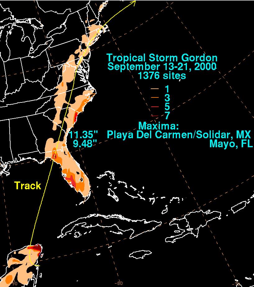
but weakened to a tropical storm before making landfall in Florida. Gordon left 24 dead and 2 missing and $10.8 million (2000 USD) in damage.
moved off the coast of Africa on September 4 and tracked westward across the Atlantic Ocean without strengthening. On September 9 and 10, the tropical wave moved though the Lesser Antilles
bringing local heavy rainfall and wind gusts reaching 35 mph (55 km/h). The wave then moved west-northwest and developed a well defined centre on September 12 in the central Caribbean. Satellite photos on September 13 indicated that the convective
pattern in the system was disorganised. However, later that day, a broad low pressure area had developed along the wave's axis based on surface observations about 118 mi (189.9 km) southeast of Cozumel
, Mexico
. Early on September 14, it was estimated from satellite imagery that the low pressure system was near tropical depression strength, even though the convection was still disorganised.
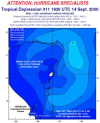
The system was upgraded to tropical depression status in the morning of September 14, based on a report from a reconnaissance aircraft
. The developing system moved slowly northwestward across the northern Yucatán Peninsula
. Later that day, the depression's centre moved inland over the Yucatán Peninsula. The depression moved slowly to the northwest across the northern part of the peninsula without emerging over water, therefore, the depression did not gain intensity. At this time, the predicted track for the system was highly uncertain due to different computer models forecasting different tracks. The official forecast predicted a northwestward movement into the western Gulf of Mexico
, but some models predicted the low to move towards northwestern Florida
, while another model predicted the low to move southwards into the Bay of Campeche
. Late on September 15 the tropical depression moved off the north coast of the Yucatán and into the Gulf of Mexico, where it showed signs of better organisation. The future track was still very uncertain, but a few models forecast for the depression to move northeastwards towards Florida, so the official forecast track was shifted slightly to the right, resulting with a more northerly track. Early on September 16, data from Hurricane Hunter aircraft indicated that the storm had strengthened to about 60 mph (95 km/h) at the surface, and the sea-level pressure had fallen to 1003 mbar (29.6 inHg), therefore, it was upgraded to Tropical Storm Gordon. At this time, the storm was moving northeastward towards the Big Bend in Florida
, continuing to slowly intensify. The official forecast track was again shifted, forecasting Gordon to track to the northeast. Early on September 17, a ship reported 75 mph (120 km/h) winds, indicating that Gordon had attained hurricane strength. Gordon reached a peak intensity of 80 mph (130 km/h), six hours later while located about 190 mi (305.8 km) southwest of Tampa
, Florida
.
 Later that day, Gordon began to weaken due to entrainment
from the south and increasing vertical wind shear
. Gordon was downgraded to a tropical storm as it neared the Florida
coast. The storm made landfall just northwest of Cedar Key, Florida
early on September 18 as a tropical storm with 60 mph (95 mph) winds. After moving inland, interaction with the land and cool, dry air further weakened the storm. Gordon weakened to a tropical depression nine hours after landfall, and six hours later, Gordon had merged with a frontal system over southeastern Georgia
and had undergone extratropical transition, as it moved to the northeast. On September 21, the system merged with a large extratropical
system over eastern Canada.
loaded up supplies on September 16 when the National Hurricane Centre issued a hurricane watch along Florida's west coast from Bonita Beach
to the Suwanee River. The hurricane watch extended northward and westward later in the day to Apalachicola. In various areas of Florida, spokesmen for the Emergency Operations Center
advised residents to prepare for the storm and monitor the track of the approaching hurricane. At Cape Canaveral
, NASA
also took precautions against the hurricane, as the storm could force NASA to move the Discovery
space shuttle off its launch pad at the seaside and into the hangar. Residents in Alabama
, Mississippi
and Louisiana
were also advised by radio to keep track of the approaching hurricane.
Hurricane warnings were initiated on September 17 for areas along the Florida coast from Anna Maria Island
to Ochlockonee River
. Tropical storm warnings were issued south of Anna Maria Island to Bonita Beach and west of Ochlockonee River to Indian Pass. Tropical storm warnings were also issued along the east coast of the United States from Titusville
in Florida to Little River Inlet in South Carolina
. The Florida Division of Emergency Management
in Tallahassee made a mandatory evacuation in Hernando County, while voluntary evacuations are called for some of the coastal areas along Florida's west coast. Anticipating that Gordon will make landfall and move inland, two tornado watches were in effect from Sarasota to Naples
, and tornado warnings were issued from Orlando
to Vero Beach. Flash flood warnings were also in effect in parts of Florida.
and Shell Oil Company
evacuated offshore crews from the Gulf of Mexico
on September 16 in preparation for a possible hurricane threat from Hurricane Gordon, even though there was little effect on oil and gas production before that day. The Chevron Corporation expected the number of people working in the Gulf to reduce from 1,700 on September 16 to 450 the next day.
mainly due to flooding and landslides in mountainous regions. While drifting over the Yucatán Peninsula of Mexico, Gordon dropped heavy rainfall peaking at 9 inches (230 mm) in Cancún
. The storm also dumped heavy rainfall in western Cuba
with totals reaching 10 inches (254 mm).
. This caused the companies of Royal Dutch Shell
and Chevron
to suspend oil production. Gordon also forced the cruise liner Carnival's Sensation, consisting of 2,200 passengers and 900 crew members, to remain at sea for one day.
 Before Gordon made landfall in Florida
, one death occurred when a surfer drowned in the raging seas close to Pensacola
in Florida. During landfall, the storm brought a storm surge
to Cedar Key with waves over six feet high (over 1.8 m). The majority of the damage was to trees and power-lines, and as a result, 20,000 people in Florida lost power for over six hours. At the peak of the storm, 120,000 people were without electricity, mostly in the Tampa
metropolitan area. Numerous homes along the Florida coast between the Tampa Bay
area and Cedar Key received minor roof damage, and several roads near the coast experienced minor flooding due to the storm surge and were closed temporarily.
Many evacuations took place once Gordon crossed the Florida coast. The Emergency Operations Center
in Florida said authorities had arranged mandatory evacuations for coastal regions in the Citrus
, Franklin
, Hernando
, Levy
and Taylor
counties, while also recommending voluntary evacuations for numerous other counties. The Red Cross reported that the storm forced 500 people to seek refuge in shelters. Also, many flights were canceled at the Tampa International Airport
. About 200 national guardsmen were called to help cleanup the damage in flooded areas. Officials forced schools in six counties - Gilchrist
, Columbia
, Citrus, Taylor, Lafayette
and Suwannee
to close down for one day.
Gordon also spawned two tornadoes that touched down as it made landfall. One tornado touched down near Cape Coral, Florida
, damaging three homes, while an F0
tornado touched down near Ponce Inlet in Volusia County, Florida
, causing minimal damage, mainly to trees and roofs.
and Citrus County, Florida
, residents who were evacuated on the day when Gordon struck the coast were allowed early the next day to return to their homes after the storm passed.
2000 Atlantic hurricane season
The 2000 Atlantic hurricane season was the first season without a tropical cyclone in July since 1987. The season officially began on June 1, 2000, and lasted until November 30, 2000. The June through November dates conventionally delimit the period of each year when most tropical cyclones form in...
, and was the 7th named storm and 4th hurricane of the 2000 Atlantic hurricane season
2000 Atlantic hurricane season
The 2000 Atlantic hurricane season was the first season without a tropical cyclone in July since 1987. The season officially began on June 1, 2000, and lasted until November 30, 2000. The June through November dates conventionally delimit the period of each year when most tropical cyclones form in...
. Gordon was a category 1 hurricane over the Gulf of Mexico
Gulf of Mexico
The Gulf of Mexico is a partially landlocked ocean basin largely surrounded by the North American continent and the island of Cuba. It is bounded on the northeast, north and northwest by the Gulf Coast of the United States, on the southwest and south by Mexico, and on the southeast by Cuba. In...
but weakened to a tropical storm before making landfall in Florida. Gordon left 24 dead and 2 missing and $10.8 million (2000 USD) in damage.
Meteorological history
A tropical waveTropical wave
Tropical waves, easterly waves, or tropical easterly waves, also known as African easterly waves in the Atlantic region, are a type of atmospheric trough, an elongated area of relatively low air pressure, oriented north to south, which move from east to west across the tropics causing areas of...
moved off the coast of Africa on September 4 and tracked westward across the Atlantic Ocean without strengthening. On September 9 and 10, the tropical wave moved though the Lesser Antilles
Lesser Antilles
The Lesser Antilles are a long, partly volcanic island arc in the Western Hemisphere. Most of its islands form the eastern boundary of the Caribbean Sea with the Atlantic Ocean, with the remainder located in the southern Caribbean just north of South America...
bringing local heavy rainfall and wind gusts reaching 35 mph (55 km/h). The wave then moved west-northwest and developed a well defined centre on September 12 in the central Caribbean. Satellite photos on September 13 indicated that the convective
Convection
Convection is the movement of molecules within fluids and rheids. It cannot take place in solids, since neither bulk current flows nor significant diffusion can take place in solids....
pattern in the system was disorganised. However, later that day, a broad low pressure area had developed along the wave's axis based on surface observations about 118 mi (189.9 km) southeast of Cozumel
Cozumel
Cozumel is an island in the Caribbean Sea off the eastern coast of Mexico's Yucatan Peninsula, opposite Playa del Carmen, and close to the Yucatan Channel. Cozumel is one of the ten municipalities of the state of Quintana Roo...
, Mexico
Mexico
The United Mexican States , commonly known as Mexico , is a federal constitutional republic in North America. It is bordered on the north by the United States; on the south and west by the Pacific Ocean; on the southeast by Guatemala, Belize, and the Caribbean Sea; and on the east by the Gulf of...
. Early on September 14, it was estimated from satellite imagery that the low pressure system was near tropical depression strength, even though the convection was still disorganised.
The system was upgraded to tropical depression status in the morning of September 14, based on a report from a reconnaissance aircraft
Reconnaissance aircraft
A reconnaissance aircraft is a manned military aircraft designed, or adapted, to carry out aerial reconnaissance.-History:The majority of World War I aircraft were reconnaissance designs...
. The developing system moved slowly northwestward across the northern Yucatán Peninsula
Yucatán Peninsula
The Yucatán Peninsula, in southeastern Mexico, separates the Caribbean Sea from the Gulf of Mexico, with the northern coastline on the Yucatán Channel...
. Later that day, the depression's centre moved inland over the Yucatán Peninsula. The depression moved slowly to the northwest across the northern part of the peninsula without emerging over water, therefore, the depression did not gain intensity. At this time, the predicted track for the system was highly uncertain due to different computer models forecasting different tracks. The official forecast predicted a northwestward movement into the western Gulf of Mexico
Gulf of Mexico
The Gulf of Mexico is a partially landlocked ocean basin largely surrounded by the North American continent and the island of Cuba. It is bounded on the northeast, north and northwest by the Gulf Coast of the United States, on the southwest and south by Mexico, and on the southeast by Cuba. In...
, but some models predicted the low to move towards northwestern Florida
Florida
Florida is a state in the southeastern United States, located on the nation's Atlantic and Gulf coasts. It is bordered to the west by the Gulf of Mexico, to the north by Alabama and Georgia and to the east by the Atlantic Ocean. With a population of 18,801,310 as measured by the 2010 census, it...
, while another model predicted the low to move southwards into the Bay of Campeche
Bay of Campeche
The Bay of Campeche is the southern bight of the Gulf of Mexico. It is surrounded on three sides by the Mexican states of Campeche, Tabasco and Veracruz. It was named by Francisco Hernández de Córdoba and Antonio de Alaminos during their expedition in 1517...
. Late on September 15 the tropical depression moved off the north coast of the Yucatán and into the Gulf of Mexico, where it showed signs of better organisation. The future track was still very uncertain, but a few models forecast for the depression to move northeastwards towards Florida, so the official forecast track was shifted slightly to the right, resulting with a more northerly track. Early on September 16, data from Hurricane Hunter aircraft indicated that the storm had strengthened to about 60 mph (95 km/h) at the surface, and the sea-level pressure had fallen to 1003 mbar (29.6 inHg), therefore, it was upgraded to Tropical Storm Gordon. At this time, the storm was moving northeastward towards the Big Bend in Florida
Big Bend (Florida)
The Big Bend of Florida, U.S.A., is an informal region of the state with no official surveyed boundary. It includes part of the counties of the Florida Panhandle. Geologists prefer to characterize Florida’s Big Bend as the drowned karst section of the coast that occurs between the mouth of the...
, continuing to slowly intensify. The official forecast track was again shifted, forecasting Gordon to track to the northeast. Early on September 17, a ship reported 75 mph (120 km/h) winds, indicating that Gordon had attained hurricane strength. Gordon reached a peak intensity of 80 mph (130 km/h), six hours later while located about 190 mi (305.8 km) southwest of Tampa
Tâmpa
Tâmpa may refer to several villages in Romania:* Tâmpa, a village in Băcia Commune, Hunedoara County* Tâmpa, a village in Miercurea Nirajului, Mureş County* Tâmpa, a mountain in Braşov city...
, Florida
Florida
Florida is a state in the southeastern United States, located on the nation's Atlantic and Gulf coasts. It is bordered to the west by the Gulf of Mexico, to the north by Alabama and Georgia and to the east by the Atlantic Ocean. With a population of 18,801,310 as measured by the 2010 census, it...
.
Entrainment (meteorology)
Entrainment is a phenomenon of the atmosphere which occurs when a turbulent flow captures a non-turbulent flow. It is typically used to refer to the capture of a wind flow of high moisture content, or in the case of tropical cyclones, the capture of drier air....
from the south and increasing vertical wind shear
Wind shear
Wind shear, sometimes referred to as windshear or wind gradient, is a difference in wind speed and direction over a relatively short distance in the atmosphere...
. Gordon was downgraded to a tropical storm as it neared the Florida
Florida
Florida is a state in the southeastern United States, located on the nation's Atlantic and Gulf coasts. It is bordered to the west by the Gulf of Mexico, to the north by Alabama and Georgia and to the east by the Atlantic Ocean. With a population of 18,801,310 as measured by the 2010 census, it...
coast. The storm made landfall just northwest of Cedar Key, Florida
Cedar Key, Florida
Cedar Key is a city in Levy County, Florida, United States. The population was 790 at the 2000 census. According to the U.S Census estimates of 2005, the city had a population of 958. The Cedar Keys are a cluster of islands close to the mainland. Most of the developed area of the city has been on...
early on September 18 as a tropical storm with 60 mph (95 mph) winds. After moving inland, interaction with the land and cool, dry air further weakened the storm. Gordon weakened to a tropical depression nine hours after landfall, and six hours later, Gordon had merged with a frontal system over southeastern Georgia
Georgia (U.S. state)
Georgia is a state located in the southeastern United States. It was established in 1732, the last of the original Thirteen Colonies. The state is named after King George II of Great Britain. Georgia was the fourth state to ratify the United States Constitution, on January 2, 1788...
and had undergone extratropical transition, as it moved to the northeast. On September 21, the system merged with a large extratropical
Extratropical cyclone
Extratropical cyclones, sometimes called mid-latitude cyclones or wave cyclones, are a group of cyclones defined as synoptic scale low pressure weather systems that occur in the middle latitudes of the Earth having neither tropical nor polar characteristics, and are connected with fronts and...
system over eastern Canada.
Florida
Residents in FloridaFlorida
Florida is a state in the southeastern United States, located on the nation's Atlantic and Gulf coasts. It is bordered to the west by the Gulf of Mexico, to the north by Alabama and Georgia and to the east by the Atlantic Ocean. With a population of 18,801,310 as measured by the 2010 census, it...
loaded up supplies on September 16 when the National Hurricane Centre issued a hurricane watch along Florida's west coast from Bonita Beach
Bonita Springs, Florida
Bonita Springs is a city in Lee County, Florida, United States. The population was 43,914 at the 2010 census. It is part of the Cape Coral–Fort Myers Metropolitan Statistical Area. The city is located on the southwest coast of the state....
to the Suwanee River. The hurricane watch extended northward and westward later in the day to Apalachicola. In various areas of Florida, spokesmen for the Emergency Operations Center
Emergency operations center
An emergency operations center, or EOC, is a central command and control facility responsible for carrying out the principles of emergency preparedness and emergency management, or disaster management functions at a strategic level in an emergency situation, and ensuring the continuity of operation...
advised residents to prepare for the storm and monitor the track of the approaching hurricane. At Cape Canaveral
Cape Canaveral
Cape Canaveral, from the Spanish Cabo Cañaveral, is a headland in Brevard County, Florida, United States, near the center of the state's Atlantic coast. Known as Cape Kennedy from 1963 to 1973, it lies east of Merritt Island, separated from it by the Banana River.It is part of a region known as the...
, NASA
NASA
The National Aeronautics and Space Administration is the agency of the United States government that is responsible for the nation's civilian space program and for aeronautics and aerospace research...
also took precautions against the hurricane, as the storm could force NASA to move the Discovery
Space Shuttle Discovery
Space Shuttle Discovery is one of the retired orbiters of the Space Shuttle program of NASA, the space agency of the United States, and was operational from its maiden flight, STS-41-D on August 30, 1984, until its final landing during STS-133 on March 9, 2011...
space shuttle off its launch pad at the seaside and into the hangar. Residents in Alabama
Alabama
Alabama is a state located in the southeastern region of the United States. It is bordered by Tennessee to the north, Georgia to the east, Florida and the Gulf of Mexico to the south, and Mississippi to the west. Alabama ranks 30th in total land area and ranks second in the size of its inland...
, Mississippi
Mississippi
Mississippi is a U.S. state located in the Southern United States. Jackson is the state capital and largest city. The name of the state derives from the Mississippi River, which flows along its western boundary, whose name comes from the Ojibwe word misi-ziibi...
and Louisiana
Louisiana
Louisiana is a state located in the southern region of the United States of America. Its capital is Baton Rouge and largest city is New Orleans. Louisiana is the only state in the U.S. with political subdivisions termed parishes, which are local governments equivalent to counties...
were also advised by radio to keep track of the approaching hurricane.
Hurricane warnings were initiated on September 17 for areas along the Florida coast from Anna Maria Island
Anna Maria Island
Anna Maria Island, sometimes called Anna Maria Key, is a barrier island on the coast of Manatee County, Florida in the United States. It is bounded on the west by the Gulf of Mexico, on the south by Longboat Pass , on the east by Anna Maria Sound, and on the north by Tampa Bay. Anna Maria Island...
to Ochlockonee River
Ochlockonee River
The Ochlockonee River is a fast running river originating in Georgia and flowing for before terminating in Florida.- Background :The Ochlockonee originates south of the town of Sylvester in Worth County in southwest Georgia emptying into Ochlockonee Bay, then into Apalachee Bay, in Florida...
. Tropical storm warnings were issued south of Anna Maria Island to Bonita Beach and west of Ochlockonee River to Indian Pass. Tropical storm warnings were also issued along the east coast of the United States from Titusville
Titusville, Florida
Titusville is a city in Brevard County, Florida in the United States. It is the county seat of Brevard County. Nicknamed Space City, USA, Titusville is on the Indian River, west of Merritt Island and the Kennedy Space Center and south-southwest of the Canaveral National Seashore...
in Florida to Little River Inlet in South Carolina
South Carolina
South Carolina is a state in the Deep South of the United States that borders Georgia to the south, North Carolina to the north, and the Atlantic Ocean to the east. Originally part of the Province of Carolina, the Province of South Carolina was one of the 13 colonies that declared independence...
. The Florida Division of Emergency Management
Florida Division of Emergency Management
The Florida Division of Emergency Management is charged with maintaining a comprehensive statewide program of emergency management. The division ensures that Florida is prepared to respond to emergencies, recover from them, and mitigate their impacts...
in Tallahassee made a mandatory evacuation in Hernando County, while voluntary evacuations are called for some of the coastal areas along Florida's west coast. Anticipating that Gordon will make landfall and move inland, two tornado watches were in effect from Sarasota to Naples
Naples, Florida
Naples is a city in Collier County, Florida, United States. As of July 1, 2007, the U.S. Census Bureau estimated the city's population at 21,653. Naples is a principal city of the Naples–Marco Island Metropolitan Statistical Area, which had an estimated total population of 315,839 on July 1, 2007...
, and tornado warnings were issued from Orlando
Orlando, Florida
Orlando is a city in the central region of the U.S. state of Florida. It is the county seat of Orange County, and the center of the Greater Orlando metropolitan area. According to the 2010 US Census, the city had a population of 238,300, making Orlando the 79th largest city in the United States...
to Vero Beach. Flash flood warnings were also in effect in parts of Florida.
Gulf of Mexico
Chevron CorporationChevron Corporation
Chevron Corporation is an American multinational energy corporation headquartered in San Ramon, California, United States and active in more than 180 countries. It is engaged in every aspect of the oil, gas, and geothermal energy industries, including exploration and production; refining,...
and Shell Oil Company
Shell Oil Company
Shell Oil Company is the United States-based subsidiary of Royal Dutch Shell, a multinational oil company of Anglo Dutch origins, which is amongst the largest oil companies in the world. Approximately 22,000 Shell employees are based in the U.S. The head office in the U.S. is in Houston, Texas...
evacuated offshore crews from the Gulf of Mexico
Gulf of Mexico
The Gulf of Mexico is a partially landlocked ocean basin largely surrounded by the North American continent and the island of Cuba. It is bounded on the northeast, north and northwest by the Gulf Coast of the United States, on the southwest and south by Mexico, and on the southeast by Cuba. In...
on September 16 in preparation for a possible hurricane threat from Hurricane Gordon, even though there was little effect on oil and gas production before that day. The Chevron Corporation expected the number of people working in the Gulf to reduce from 1,700 on September 16 to 450 the next day.
Latin America
As a tropical wave, Gordon killed 23 people in GuatemalaGuatemala
Guatemala is a country in Central America bordered by Mexico to the north and west, the Pacific Ocean to the southwest, Belize to the northeast, the Caribbean to the east, and Honduras and El Salvador to the southeast...
mainly due to flooding and landslides in mountainous regions. While drifting over the Yucatán Peninsula of Mexico, Gordon dropped heavy rainfall peaking at 9 inches (230 mm) in Cancún
Cancún
Cancún is a city of international tourism development certified by the UNWTO . Located on the northeast coast of Quintana Roo in southern Mexico, more than 1,700 km from Mexico City, the Project began operations in 1974 as Integrally Planned Center, a pioneer of FONATUR Cancún is a city of...
. The storm also dumped heavy rainfall in western Cuba
Cuba
The Republic of Cuba is an island nation in the Caribbean. The nation of Cuba consists of the main island of Cuba, the Isla de la Juventud, and several archipelagos. Havana is the largest city in Cuba and the country's capital. Santiago de Cuba is the second largest city...
with totals reaching 10 inches (254 mm).
Atlantic Ocean
Gordon forced the evacuation of several oil platforms in the Gulf of MexicoGulf of Mexico
The Gulf of Mexico is a partially landlocked ocean basin largely surrounded by the North American continent and the island of Cuba. It is bounded on the northeast, north and northwest by the Gulf Coast of the United States, on the southwest and south by Mexico, and on the southeast by Cuba. In...
. This caused the companies of Royal Dutch Shell
Royal Dutch Shell
Royal Dutch Shell plc , commonly known as Shell, is a global oil and gas company headquartered in The Hague, Netherlands and with its registered office in London, United Kingdom. It is the fifth-largest company in the world according to a composite measure by Forbes magazine and one of the six...
and Chevron
Chevron Corporation
Chevron Corporation is an American multinational energy corporation headquartered in San Ramon, California, United States and active in more than 180 countries. It is engaged in every aspect of the oil, gas, and geothermal energy industries, including exploration and production; refining,...
to suspend oil production. Gordon also forced the cruise liner Carnival's Sensation, consisting of 2,200 passengers and 900 crew members, to remain at sea for one day.
Florida
Florida
Florida is a state in the southeastern United States, located on the nation's Atlantic and Gulf coasts. It is bordered to the west by the Gulf of Mexico, to the north by Alabama and Georgia and to the east by the Atlantic Ocean. With a population of 18,801,310 as measured by the 2010 census, it...
, one death occurred when a surfer drowned in the raging seas close to Pensacola
Pensacola
Pensacola is a city in the western part of the U.S. state of Florida.Pensacola may also refer to:* Pensacola people, a group of Native Americans* A number of places in the Florida:** Pensacola Bay** Pensacola Regional Airport...
in Florida. During landfall, the storm brought a storm surge
Storm surge
A storm surge is an offshore rise of water associated with a low pressure weather system, typically tropical cyclones and strong extratropical cyclones. Storm surges are caused primarily by high winds pushing on the ocean's surface. The wind causes the water to pile up higher than the ordinary sea...
to Cedar Key with waves over six feet high (over 1.8 m). The majority of the damage was to trees and power-lines, and as a result, 20,000 people in Florida lost power for over six hours. At the peak of the storm, 120,000 people were without electricity, mostly in the Tampa
Tâmpa
Tâmpa may refer to several villages in Romania:* Tâmpa, a village in Băcia Commune, Hunedoara County* Tâmpa, a village in Miercurea Nirajului, Mureş County* Tâmpa, a mountain in Braşov city...
metropolitan area. Numerous homes along the Florida coast between the Tampa Bay
Tampa Bay
Tampa Bay is a large natural harbor and estuary along the Gulf of Mexico on the west central coast of Florida, comprising Hillsborough Bay, Old Tampa Bay, Middle Tampa Bay, and Lower Tampa Bay."Tampa Bay" is not the name of any municipality...
area and Cedar Key received minor roof damage, and several roads near the coast experienced minor flooding due to the storm surge and were closed temporarily.
Many evacuations took place once Gordon crossed the Florida coast. The Emergency Operations Center
Emergency operations center
An emergency operations center, or EOC, is a central command and control facility responsible for carrying out the principles of emergency preparedness and emergency management, or disaster management functions at a strategic level in an emergency situation, and ensuring the continuity of operation...
in Florida said authorities had arranged mandatory evacuations for coastal regions in the Citrus
Citrus County, Florida
Citrus County is a county located in the U.S. state of Florida. As of 2000, the population was 118,085. The U.S. Census Bureau 2008 estimate for the county was 141,416 . Its county seat is Inverness, Florida...
, Franklin
Franklin County, Florida
Franklin County is a coastal county located in the panhandle of the U.S. state of Florida. As of 2000, the population was 11,057. The U.S. Census Bureau 2005 estimate for the county is 11,177...
, Hernando
Hernando County, Florida
Hernando County is a county located in the U.S. state of Florida. As of 2000, the population was 130,802. The U.S. Census Bureau 2006 estimate for the county is 165,409 . Its county seat is Brooksville, Florida. The majority of the county's population is in Spring Hill, west portion of Hernando...
, Levy
Levy County, Florida
Levy County is a county located in the state of Florida. As of 2000, the population was 34,450. The U.S. Census Bureau 2005 estimate for the county is 37,998. Its county seat is Bronson, Florida. Levy is pronounced lee vee.- History :...
and Taylor
Taylor County, Florida
Taylor County is a county located in the state of Florida. As of 2000, the population was 19,256. The U.S. Census Bureau 2005 estimate for the county was 19,622 . Its county seat is Perry, Florida.- History :Taylor County was created in 1856...
counties, while also recommending voluntary evacuations for numerous other counties. The Red Cross reported that the storm forced 500 people to seek refuge in shelters. Also, many flights were canceled at the Tampa International Airport
Tampa International Airport
Tampa International Airport is a major public airport located six nautical miles west of the central business district of Tampa, in Hillsborough County, Florida, United States. This airport is publicly owned by Hillsborough County Aviation Authority...
. About 200 national guardsmen were called to help cleanup the damage in flooded areas. Officials forced schools in six counties - Gilchrist
Gilchrist County, Florida
Gilchrist County is a rural county located in the U.S. state of Florida. As of 2000, the population was 14,437. The U.S. Census Bureau 2005 estimate for the county is 16,402. Gilchrist County has only one traffic light in the entire county and has no road with more than one lane of traffic...
, Columbia
Columbia County, Florida
Columbia County is a county located in the U.S. state of Florida. As of 2000, the population was 56,513. The U.S. Census Bureau 2005 estimate for the county is 64,040 . Its county seat is Lake City, Florida....
, Citrus, Taylor, Lafayette
Lafayette County, Florida
Lafayette County is a county located in the state of Florida. As of 2000, the population was 7,022. It is the second least populated county in the state, having one more resident, according to the 2000 census, than Liberty County, Florida. The U.S. Census Bureau 2005 estimate for the county is...
and Suwannee
Suwannee County, Florida
Suwannee County is a county located in the state of Florida. As of 2000, the population was 34,844. The U.S. Census Bureau 2005 estimate for the county was 38,624 . Its county seat is Live Oak, Florida. Suwannee County was a dry county until August, 2011.....
to close down for one day.
Gordon also spawned two tornadoes that touched down as it made landfall. One tornado touched down near Cape Coral, Florida
Cape Coral, Florida
Cape Coral is a municipality located in Lee County, Florida, United States, on the Gulf of Mexico. Founded in 1957 and developed as a master-planned, pre-platted community, the city grew to a population of 154,305 by the year 2010. With an area of , Cape Coral is the largest city between Tampa and...
, damaging three homes, while an F0
Fujita scale
The Fujita scale , or Fujita-Pearson scale, is a scale for rating tornado intensity, based primarily on the damage tornadoes inflict on human-built structures and vegetation...
tornado touched down near Ponce Inlet in Volusia County, Florida
Volusia County, Florida
Volusia County is a county located in the state of Florida. The U.S. Census Bureau 2010 official county's population was 494,593 . Its county seat is DeLand, and its most populous city is currently Deltona....
, causing minimal damage, mainly to trees and roofs.
Carolinas
Flooding in North Carolina occurred as the storm moved up the East Coast, indirectly killing two people when a car lost control and struck a tractor trailer during the storm. Two men in a fishing boat were also reported missing. Hoffman Forest, North Carolina received 5.71 inches (145 mm) of rain. In South Carolina, there was also flooding from heavy rain. Despite the rain, Gordon did little to help a drought that had been affecting the southeastern United States.Aftermath
In Levy County, FloridaLevy County, Florida
Levy County is a county located in the state of Florida. As of 2000, the population was 34,450. The U.S. Census Bureau 2005 estimate for the county is 37,998. Its county seat is Bronson, Florida. Levy is pronounced lee vee.- History :...
and Citrus County, Florida
Citrus County, Florida
Citrus County is a county located in the U.S. state of Florida. As of 2000, the population was 118,085. The U.S. Census Bureau 2008 estimate for the county was 141,416 . Its county seat is Inverness, Florida...
, residents who were evacuated on the day when Gordon struck the coast were allowed early the next day to return to their homes after the storm passed.
See also
- Other storms of the same name
- List of North Carolina hurricanes (1980–present)
- Timeline of the 2000 Atlantic hurricane seasonTimeline of the 2000 Atlantic hurricane seasonThe Timeline of the 2000 Atlantic hurricane season documents all the storm formations, strengthening, weakening, landfalls, extratropical transitions, as well as dissipation...