
.gif)
Tropical Storm Barry (2007)
Encyclopedia
Tropical Storm Barry was a rapidly-forming tropical cyclone
that made landfall
on Florida
, United States
, in early June 2007. The second named storm
of the 2007 Atlantic hurricane season
, Barry developed from a trough
of low pressure in the southeastern Gulf of Mexico
on June 1. It tracked rapidly northeastward, reaching peak winds of 60 mph (95 km/h) before weakening and making landfall near Tampa Bay
as a tropical depression. Barry quickly lost tropical characteristics after wind shear
removed much of the convection, and early on June 3 it completed the transition into an extratropical cyclone
. The extratropical remnants tracked up the East Coast of the United States
, and were absorbed by a larger extratropical cyclone on June 5.
The precursor trough produced heavy rainfall across the western Caribbean Sea, which on Cuba
unofficially reached over 7.8 inches (200 mm). Outer rainbands in Pinar del Río Province
injured three and damaged 55 houses. In Florida
, Barry dropped a moderate amount of precipitation across the drought-ridden state; rainfall peaked at 6.99 inches (178 mm). The rain caused some flooding and wet roads, which led to two indirect traffic fatalities. Rough seas killed one Florida surfer in Pinellas County
. In Florida and Georgia
, the precipitation assisted firefighters in combating severe wildfires. Overall damage from the storm was minor.
over the Yucatán Peninsula
produced a small area of convection
over the Yucatán Channel
. Convection increased in association with the trough, and the next day a broad envelop of cyclonic turning developed within the system. By May 30, the moisture from the trough extended from Nicaragua
through the southeastern Gulf of Mexico
, with the greatest area of convection near Cuba
. A westward moving tropical wave
spawned a broad area of low pressure on May 30, and by May 31 a circulation developed within the system to the southeast of Cozumel
, Mexico. The low moved north-northeastward, and gradually became better organized despite high amounts of vertical wind shear
. The deep convection became more concentrated near the center, and it is estimated the system developed into a tropical depression at 1200 UTC on June 1 just to the northwest of the western tip of Cuba
. Operationally, it was not classified until eleven hours later.
 The depression developed a large area of squalls, and organized enough to warrant a Hurricane Hunters
flight into the area. The plane reported flight level winds of 60 mi/h and a pressure of 1000 mbar
near the increasingly well-defined low-level circulation. Initially it maintained characteristics of both a tropical and subtropical cyclone
, although deep convection continued to organize near the center; based on the observations, the National Hurricane Center
initiated advisories on Tropical Storm Barry at 2100 UTC on June 1 while the storm was centered about 235 miles (375 km) west of Key West, Florida
. Embedded within the southwesterly flow ahead of an approaching mid-level trough, it tracked quickly northward, and early on June 2 attained peak winds of 60 mph (95 km/h).
Shortly after reaching peak intensity, strong wind shear removed most of the deep convection; the cloud pattern consisted of an exposed yet well-defined center surrounded by a curved convective band extending from Cuba along the eastern Gulf of Mexico. The center became elongated and weakened as it accelerated northeastward, and at 1400 UTC on June 2 Barry made landfall
near Tampa, Florida
, as a weakening tropical depression. As it continued inland, it rapidly lost tropical characteristics, and later that day the National Hurricane Center discontinued advisories on Barry while it was located over northeastern Florida. The extratropical
remnants strengthened as the system continued northeastward, and on June 3 it moved ashore along South Carolina
. Spiral bands developed to the north of the system as it moved up the coast, and a large plume of moisture extended well ahead of the low-level circulation. Late on June 4, the extratropical remnant entered New England
, and late on June 5 the remnants of Barry were absorbed by a larger extratropical cyclone near the border between the U.S. state
of Maine
and the Canadian province
of Quebec
.
 Coinciding with its classification as a tropical storm, the National Hurricane Center
issued a tropical storm warning
for the west coast of Florida
from Bonita Beach through Keaton Beach, with a tropical storm watch declared from Keaton Beach northward to Saint Marks. An inland tropical storm warning was also issued for non-coastal and non-tidal areas of Charlotte
, Citrus
, DeSoto
, Hardee
, Hernando
, Highlands
, Lee
, Levy
, Manatee
, Pasco
, Pinellas
, Polk
, Sarasota
, and Sumter
counties. The passage of the storm resulted in an increased threat for rip currents, with officials recommending that swimmers stay out of the water until the storm leaves the area. A tornado watch was also posted for the southern portion of the state, though was dropped after the storm weakened.
After becoming an extratropical cyclone, local National Weather Service
offices issued flood watches for portions of South Carolina
, much of eastern North Carolina
, southeastern Virginia
, and southeastern Maryland
. Later, flood and flash flood
watches were issued for southeast Pennsylvania
, northern Delaware
, northern New Jersey
, east-central New York
, and southern New England
. Wind and lake wind advisories were posted in parts of Georgia.
, the precursor trough produced about 2.76 inches (70 mm) of rainfall in about ten hours.
The precursor system dropped heavy rainfall across western Cuba, peaking at 12.0 inches (305 mm) in Sancti Spíritus Province
. Several other locations recorded over 4 inches (100 mm) of precipitation, which caused flooding along rivers and low-lying areas. The city of Guane
was isolated after flooding cut off communications. In total, more than 2,000 people were evacuated due to the threat for flooding. Additionally, the precursor disturbance spawned four tornadoes in Pinar del Río Province; the tornadoes injured three people and damaged fifty-five houses, of which four collapsed.
, peaking at 6.99 inches (178 mm) at Palm Beach International Airport
; several other locations reported over 3 inches (75 mm). The rainfall alleviated persistent drought conditions and assisted in combating severe wildfires
across the state. In Brevard County
, the rainfall closed a portion of Eau Gallie Boulevard after a large sinkhole developed. Several other roads across the area were flooded, and on Interstate 95
near Lake Worth
, a sinkhole closed two lanes of traffic. Wet roads caused several traffic accidents across the state; in both Brevard and Volusia
counties, a motorist was killed from an accident. On Interstate 4
, a tractor trailer led to disruptions near Orlando
after it crashed into a guardrail.
The storm produced heavy surf along the western coastline, as well as a storm tide
of 4.78 feet (1.46 m) at Clearwater Beach
. The wave action caused minor beach erosion, with 50–60 feet (15–18 m) of sand washed away at Bradenton Beach
. The increased ocean action caused minor flooding along several roads in the Tampa Bay
area, which trapped some automobile travelers. At Indian Shores
, a woman died after sustaining injuries from the rough surf.
High winds across the state included a report of 47 mph (76 km/h) near the state's southeastern coastline. The winds downed some trees and resulted in power outages, and one person in Carrolwood
was injured after a tree fell onto a house. The storm spawned several tornadoes in the southern portion of the state, some of which damaged fences and power lines. One possible tornado in Goulds
left about 2,000 people without power after it knocked down a power line. Another tornado near Miami
damaged a few homes and trees.
peaked at 8 inches (203 mm) in Mount Vernon
. The precipitation assisted firefighters in combating wildfires in the southern portion of the state, which gave thousands of workers a brief respite after they had fought the fires daily for over a month. The rainfall caused some minor flooding, and in Savannah
a few minor traffic accidents occurred. Gusty winds blew down trees and power lines, and along the coast, rough surf was reported. Heavy rainfall from the storm spread across much of the East Coast of the United States
. State totals peaked at 6.12 inches (155 mm) near Hardeeville, South Carolina
, 3.73 inches (95 mm) in Fuquay-Varina, North Carolina
, and 3.75 inches (95 mm) near Pennington Gap, Virginia
. High winds also occurred in South Carolina.
The extratropical remnants of Barry produced gusty winds alone the Atlantic coastline which peaked at 60 mph (97 km/h) near Charleston, South Carolina
. Around 200 houses in Craven County, North Carolina
, were without power after winds downed a power line. In North Carolina, adverse conditions from the storm delayed an elimination baseball game between the East Carolina University
and Western Carolina University
teams. In southeastern Virginia
, the remnants of Barry caused over 60 traffic accidents, which resulted in 10 injuries. Rough seas off of Cape Fear left a sailboat containing three people requiring rescue from the Coast Guard
. Rainfall extended into the Mid-Atlantic states
through New England
, with 4.50 inches (113 mm) reported at Absecon, New Jersey
, 3.91 inches (99 mm) recorded near Central Park, New York
, and 3.19 inches (81 mm) at Taunton, Massachusetts
. The remnants of Tropical Storm Barry contributed to heavy rainfall and flooding in the Finger Lakes
region of New York State. Roads and several driveways were washed out. Flash flood
ing was also reported in southeast New York, and high wind gusts caused sporadic tree damage. In New Jersey, northeast onshore flow associated with the remnants of Barry produced high tides and minor coastal flooding.
Tropical cyclone
A tropical cyclone is a storm system characterized by a large low-pressure center and numerous thunderstorms that produce strong winds and heavy rain. Tropical cyclones strengthen when water evaporated from the ocean is released as the saturated air rises, resulting in condensation of water vapor...
that made landfall
Landfall (meteorology)
Landfall is the event of a tropical cyclone or a waterspout coming onto land after being over water. When a waterspout makes landfall it is reclassified as a tornado, which can then cause damage inland...
on Florida
Florida
Florida is a state in the southeastern United States, located on the nation's Atlantic and Gulf coasts. It is bordered to the west by the Gulf of Mexico, to the north by Alabama and Georgia and to the east by the Atlantic Ocean. With a population of 18,801,310 as measured by the 2010 census, it...
, United States
United States
The United States of America is a federal constitutional republic comprising fifty states and a federal district...
, in early June 2007. The second named storm
Tropical cyclone
A tropical cyclone is a storm system characterized by a large low-pressure center and numerous thunderstorms that produce strong winds and heavy rain. Tropical cyclones strengthen when water evaporated from the ocean is released as the saturated air rises, resulting in condensation of water vapor...
of the 2007 Atlantic hurricane season
2007 Atlantic hurricane season
The 2007 Atlantic hurricane season was an active Atlantic hurricane season that produced 17 tropical cyclones, 15 tropical storms, six hurricanes, and two major hurricanes. It officially started on June 1 and ended on November 30, dates which conventionally delimit the...
, Barry developed from a trough
Trough (meteorology)
A trough is an elongated region of relatively low atmospheric pressure, often associated with fronts.Unlike fronts, there is not a universal symbol for a trough on a weather chart. The weather charts in some countries or regions mark troughs by a line. In the United States, a trough may be marked...
of low pressure in the southeastern Gulf of Mexico
Gulf of Mexico
The Gulf of Mexico is a partially landlocked ocean basin largely surrounded by the North American continent and the island of Cuba. It is bounded on the northeast, north and northwest by the Gulf Coast of the United States, on the southwest and south by Mexico, and on the southeast by Cuba. In...
on June 1. It tracked rapidly northeastward, reaching peak winds of 60 mph (95 km/h) before weakening and making landfall near Tampa Bay
Tampa Bay
Tampa Bay is a large natural harbor and estuary along the Gulf of Mexico on the west central coast of Florida, comprising Hillsborough Bay, Old Tampa Bay, Middle Tampa Bay, and Lower Tampa Bay."Tampa Bay" is not the name of any municipality...
as a tropical depression. Barry quickly lost tropical characteristics after wind shear
Wind shear
Wind shear, sometimes referred to as windshear or wind gradient, is a difference in wind speed and direction over a relatively short distance in the atmosphere...
removed much of the convection, and early on June 3 it completed the transition into an extratropical cyclone
Extratropical cyclone
Extratropical cyclones, sometimes called mid-latitude cyclones or wave cyclones, are a group of cyclones defined as synoptic scale low pressure weather systems that occur in the middle latitudes of the Earth having neither tropical nor polar characteristics, and are connected with fronts and...
. The extratropical remnants tracked up the East Coast of the United States
East Coast of the United States
The East Coast of the United States, also known as the Eastern Seaboard, refers to the easternmost coastal states in the United States, which touch the Atlantic Ocean and stretch up to Canada. The term includes the U.S...
, and were absorbed by a larger extratropical cyclone on June 5.
The precursor trough produced heavy rainfall across the western Caribbean Sea, which on Cuba
Cuba
The Republic of Cuba is an island nation in the Caribbean. The nation of Cuba consists of the main island of Cuba, the Isla de la Juventud, and several archipelagos. Havana is the largest city in Cuba and the country's capital. Santiago de Cuba is the second largest city...
unofficially reached over 7.8 inches (200 mm). Outer rainbands in Pinar del Río Province
Pinar del Río Province
Pinar del Río is one of the provinces of Cuba. It is at the western end of the island of Cuba.-Geography:The Pinar del Río province is Cuba's westernmost province and contains one of Cuba's three main mountain ranges, the Cordillera de Guaniguanico, divided into the easterly Sierra del Rosario and...
injured three and damaged 55 houses. In Florida
Florida
Florida is a state in the southeastern United States, located on the nation's Atlantic and Gulf coasts. It is bordered to the west by the Gulf of Mexico, to the north by Alabama and Georgia and to the east by the Atlantic Ocean. With a population of 18,801,310 as measured by the 2010 census, it...
, Barry dropped a moderate amount of precipitation across the drought-ridden state; rainfall peaked at 6.99 inches (178 mm). The rain caused some flooding and wet roads, which led to two indirect traffic fatalities. Rough seas killed one Florida surfer in Pinellas County
Pinellas County, Florida
Pinellas County is a county located in the state of Florida. Its county seat is Clearwater, Florida, and its largest city is St. Petersburg. This county is contained entirely within the telephone area code 727, except for some sections of Oldsmar, which have the area code 813...
. In Florida and Georgia
Georgia (U.S. state)
Georgia is a state located in the southeastern United States. It was established in 1732, the last of the original Thirteen Colonies. The state is named after King George II of Great Britain. Georgia was the fourth state to ratify the United States Constitution, on January 2, 1788...
, the precipitation assisted firefighters in combating severe wildfires. Overall damage from the storm was minor.
Meteorological history
By late on May 29, a weak troughTrough (meteorology)
A trough is an elongated region of relatively low atmospheric pressure, often associated with fronts.Unlike fronts, there is not a universal symbol for a trough on a weather chart. The weather charts in some countries or regions mark troughs by a line. In the United States, a trough may be marked...
over the Yucatán Peninsula
Yucatán Peninsula
The Yucatán Peninsula, in southeastern Mexico, separates the Caribbean Sea from the Gulf of Mexico, with the northern coastline on the Yucatán Channel...
produced a small area of convection
Convection
Convection is the movement of molecules within fluids and rheids. It cannot take place in solids, since neither bulk current flows nor significant diffusion can take place in solids....
over the Yucatán Channel
Yucatán Channel
The Yucatán Channel is a strait between Mexico and Cuba. It connects the Yucatán Basin of the Caribbean Sea with the Gulf of Mexico. The strait is across between Cape Catoche in Mexico and Cape San Antonio, Cuba and reaches a maximum depth of .-References:...
. Convection increased in association with the trough, and the next day a broad envelop of cyclonic turning developed within the system. By May 30, the moisture from the trough extended from Nicaragua
Nicaragua
Nicaragua is the largest country in the Central American American isthmus, bordered by Honduras to the north and Costa Rica to the south. The country is situated between 11 and 14 degrees north of the Equator in the Northern Hemisphere, which places it entirely within the tropics. The Pacific Ocean...
through the southeastern Gulf of Mexico
Gulf of Mexico
The Gulf of Mexico is a partially landlocked ocean basin largely surrounded by the North American continent and the island of Cuba. It is bounded on the northeast, north and northwest by the Gulf Coast of the United States, on the southwest and south by Mexico, and on the southeast by Cuba. In...
, with the greatest area of convection near Cuba
Cuba
The Republic of Cuba is an island nation in the Caribbean. The nation of Cuba consists of the main island of Cuba, the Isla de la Juventud, and several archipelagos. Havana is the largest city in Cuba and the country's capital. Santiago de Cuba is the second largest city...
. A westward moving tropical wave
Tropical wave
Tropical waves, easterly waves, or tropical easterly waves, also known as African easterly waves in the Atlantic region, are a type of atmospheric trough, an elongated area of relatively low air pressure, oriented north to south, which move from east to west across the tropics causing areas of...
spawned a broad area of low pressure on May 30, and by May 31 a circulation developed within the system to the southeast of Cozumel
Cozumel
Cozumel is an island in the Caribbean Sea off the eastern coast of Mexico's Yucatan Peninsula, opposite Playa del Carmen, and close to the Yucatan Channel. Cozumel is one of the ten municipalities of the state of Quintana Roo...
, Mexico. The low moved north-northeastward, and gradually became better organized despite high amounts of vertical wind shear
Wind shear
Wind shear, sometimes referred to as windshear or wind gradient, is a difference in wind speed and direction over a relatively short distance in the atmosphere...
. The deep convection became more concentrated near the center, and it is estimated the system developed into a tropical depression at 1200 UTC on June 1 just to the northwest of the western tip of Cuba
Cuba
The Republic of Cuba is an island nation in the Caribbean. The nation of Cuba consists of the main island of Cuba, the Isla de la Juventud, and several archipelagos. Havana is the largest city in Cuba and the country's capital. Santiago de Cuba is the second largest city...
. Operationally, it was not classified until eleven hours later.
Hurricane Hunters
The Hurricane Hunters are aircraft that fly into tropical cyclones in the North Atlantic Ocean and Northeastern Pacific Ocean for the specific purpose of directly measuring weather data in and around those storms. In the United States, the Air Force, Navy, and NOAA units have all participated in...
flight into the area. The plane reported flight level winds of 60 mi/h and a pressure of 1000 mbar
Bar (unit)
The bar is a unit of pressure equal to 100 kilopascals, and roughly equal to the atmospheric pressure on Earth at sea level. Other units derived from the bar are the megabar , kilobar , decibar , centibar , and millibar...
near the increasingly well-defined low-level circulation. Initially it maintained characteristics of both a tropical and subtropical cyclone
Subtropical cyclone
A subtropical cyclone is a weather system that has some characteristics of a tropical and an extratropical cyclone. As early as the 1950s, meteorologists were unclear whether they should be characterized as tropical or extratropical cyclones. They were officially recognized by the National...
, although deep convection continued to organize near the center; based on the observations, the National Hurricane Center
National Hurricane Center
The National Hurricane Center , located at Florida International University in Miami, Florida, is the division of the National Weather Service responsible for tracking and predicting weather systems within the tropics between the Prime Meridian and the 140th meridian west poleward to the 30th...
initiated advisories on Tropical Storm Barry at 2100 UTC on June 1 while the storm was centered about 235 miles (375 km) west of Key West, Florida
Key West, Florida
Key West is a city in Monroe County, Florida, United States. The city encompasses the island of Key West, the part of Stock Island north of U.S. 1 , Sigsbee Park , Fleming Key , and Sunset Key...
. Embedded within the southwesterly flow ahead of an approaching mid-level trough, it tracked quickly northward, and early on June 2 attained peak winds of 60 mph (95 km/h).
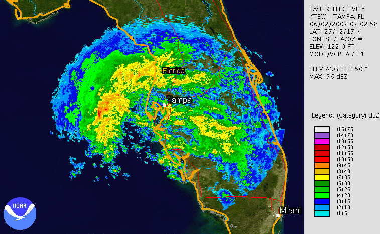
Shortly after reaching peak intensity, strong wind shear removed most of the deep convection; the cloud pattern consisted of an exposed yet well-defined center surrounded by a curved convective band extending from Cuba along the eastern Gulf of Mexico. The center became elongated and weakened as it accelerated northeastward, and at 1400 UTC on June 2 Barry made landfall
Landfall (meteorology)
Landfall is the event of a tropical cyclone or a waterspout coming onto land after being over water. When a waterspout makes landfall it is reclassified as a tornado, which can then cause damage inland...
near Tampa, Florida
Tampa, Florida
Tampa is a city in the U.S. state of Florida. It serves as the county seat for Hillsborough County. Tampa is located on the west coast of Florida. The population of Tampa in 2010 was 335,709....
, as a weakening tropical depression. As it continued inland, it rapidly lost tropical characteristics, and later that day the National Hurricane Center discontinued advisories on Barry while it was located over northeastern Florida. The extratropical
Extratropical cyclone
Extratropical cyclones, sometimes called mid-latitude cyclones or wave cyclones, are a group of cyclones defined as synoptic scale low pressure weather systems that occur in the middle latitudes of the Earth having neither tropical nor polar characteristics, and are connected with fronts and...
remnants strengthened as the system continued northeastward, and on June 3 it moved ashore along South Carolina
South Carolina
South Carolina is a state in the Deep South of the United States that borders Georgia to the south, North Carolina to the north, and the Atlantic Ocean to the east. Originally part of the Province of Carolina, the Province of South Carolina was one of the 13 colonies that declared independence...
. Spiral bands developed to the north of the system as it moved up the coast, and a large plume of moisture extended well ahead of the low-level circulation. Late on June 4, the extratropical remnant entered New England
New England
New England is a region in the northeastern corner of the United States consisting of the six states of Maine, New Hampshire, Vermont, Massachusetts, Rhode Island, and Connecticut...
, and late on June 5 the remnants of Barry were absorbed by a larger extratropical cyclone near the border between the U.S. state
U.S. state
A U.S. state is any one of the 50 federated states of the United States of America that share sovereignty with the federal government. Because of this shared sovereignty, an American is a citizen both of the federal entity and of his or her state of domicile. Four states use the official title of...
of Maine
Maine
Maine is a state in the New England region of the northeastern United States, bordered by the Atlantic Ocean to the east and south, New Hampshire to the west, and the Canadian provinces of Quebec to the northwest and New Brunswick to the northeast. Maine is both the northernmost and easternmost...
and the Canadian province
Provinces and territories of Canada
The provinces and territories of Canada combine to make up the world's second-largest country by area. There are ten provinces and three territories...
of Quebec
Quebec
Quebec or is a province in east-central Canada. It is the only Canadian province with a predominantly French-speaking population and the only one whose sole official language is French at the provincial level....
.
Preparations
National Hurricane Center
The National Hurricane Center , located at Florida International University in Miami, Florida, is the division of the National Weather Service responsible for tracking and predicting weather systems within the tropics between the Prime Meridian and the 140th meridian west poleward to the 30th...
issued a tropical storm warning
Tropical cyclone warnings and watches
Warnings and watches are two levels of alert issued by national weather forecasting bodies to coastal areas threatened by the imminent approach of a tropical cyclone of tropical storm or hurricane intensity. They are notices to the local population and civil authorities to make appropriate...
for the west coast of Florida
Florida
Florida is a state in the southeastern United States, located on the nation's Atlantic and Gulf coasts. It is bordered to the west by the Gulf of Mexico, to the north by Alabama and Georgia and to the east by the Atlantic Ocean. With a population of 18,801,310 as measured by the 2010 census, it...
from Bonita Beach through Keaton Beach, with a tropical storm watch declared from Keaton Beach northward to Saint Marks. An inland tropical storm warning was also issued for non-coastal and non-tidal areas of Charlotte
Charlotte County, Florida
Charlotte County is a county located in the U.S. state of Florida. As of 2000, the population was 141,627. In 2005, the population of the MSA was 154,030.The U.S. Census Bureau 2007 estimate for the county was 152,814...
, Citrus
Citrus County, Florida
Citrus County is a county located in the U.S. state of Florida. As of 2000, the population was 118,085. The U.S. Census Bureau 2008 estimate for the county was 141,416 . Its county seat is Inverness, Florida...
, DeSoto
DeSoto County, Florida
DeSoto County is a county located in the U.S. state of Florida. As of 2000, the population was 32,209. The U.S. Census Bureau 2005 estimate for the county is 35,406 . Its county seat is Arcadia, Florida. The county comprises the Arcadia, Florida Micropolitan Statistical Area.- History :DeSoto...
, Hardee
Hardee County, Florida
Hardee County is a county located in the U.S. state of Florida. As of 2000, the population was 26,938. The U.S. Census Bureau 2005 estimate for the county is 28,286 . Its county seat is Wauchula, Florida. The county comprises the Wauchula, Florida, Micropolitan Statistical Area.- History :It...
, Hernando
Hernando County, Florida
Hernando County is a county located in the U.S. state of Florida. As of 2000, the population was 130,802. The U.S. Census Bureau 2006 estimate for the county is 165,409 . Its county seat is Brooksville, Florida. The majority of the county's population is in Spring Hill, west portion of Hernando...
, Highlands
Highlands County, Florida
Highlands County is a county located in the U.S. state of Florida. The U.S. Census Bureau 2006 estimate for the population was 97,346. Its county seat is Sebring, Florida. The county comprises the Sebring, Florida, Micropolitan Statistical Area.- History :...
, Lee
Lee County, Florida
Lee County is a county located in the U.S. state of Florida. Located in southwest Florida, the principal cities in the county are Fort Myers and Cape Coral...
, Levy
Levy County, Florida
Levy County is a county located in the state of Florida. As of 2000, the population was 34,450. The U.S. Census Bureau 2005 estimate for the county is 37,998. Its county seat is Bronson, Florida. Levy is pronounced lee vee.- History :...
, Manatee
Manatee County, Florida
Manatee County is a county in the state of Florida. According to the 2010 census by the U.S. Census Bureau there are 322,833 people living in Manatee Country.Manatee County is part of the North Port-Bradenton-Sarasota Metropolitan Statistical Area...
, Pasco
Pasco County, Florida
Pasco County is a county located in the U.S. state of Florida. As of 2000, the population was 344,765. The July 1, 2007 census estimate according to the U.S. Census Bureau for the county is 462,715. Its county seat is Dade City, Florida which is in the northeast part of the county - somewhat...
, Pinellas
Pinellas County, Florida
Pinellas County is a county located in the state of Florida. Its county seat is Clearwater, Florida, and its largest city is St. Petersburg. This county is contained entirely within the telephone area code 727, except for some sections of Oldsmar, which have the area code 813...
, Polk
Polk County, Florida
Polk County is located in central Florida between the Tampa Bay and Greater Orlando metropolitan areas. The county was established by the state government in 1861 on the eve of the American Civil War and named after former United States president James K. Polk. The county seat is Bartow and its...
, Sarasota
Sarasota County, Florida
Sarasota County is a county located in the U.S. state of Florida. The U.S. Census Bureau 2008 estimate for the county was 372,057. Its county seat is Sarasota, Florida....
, and Sumter
Sumter County, Florida
Sumter County is a county located in the state of Florida, United States. As of the 2000 Census, the population was 53,345. The 2006 Census estimate puts its population at 68,768 . Its county seat is Bushnell, Florida and the largest incorporated municipality is Wildwood, Florida. The Villages,...
counties. The passage of the storm resulted in an increased threat for rip currents, with officials recommending that swimmers stay out of the water until the storm leaves the area. A tornado watch was also posted for the southern portion of the state, though was dropped after the storm weakened.
After becoming an extratropical cyclone, local National Weather Service
National Weather Service
The National Weather Service , once known as the Weather Bureau, is one of the six scientific agencies that make up the National Oceanic and Atmospheric Administration of the United States government...
offices issued flood watches for portions of South Carolina
South Carolina
South Carolina is a state in the Deep South of the United States that borders Georgia to the south, North Carolina to the north, and the Atlantic Ocean to the east. Originally part of the Province of Carolina, the Province of South Carolina was one of the 13 colonies that declared independence...
, much of eastern North Carolina
North Carolina
North Carolina is a state located in the southeastern United States. The state borders South Carolina and Georgia to the south, Tennessee to the west and Virginia to the north. North Carolina contains 100 counties. Its capital is Raleigh, and its largest city is Charlotte...
, southeastern Virginia
Virginia
The Commonwealth of Virginia , is a U.S. state on the Atlantic Coast of the Southern United States. Virginia is nicknamed the "Old Dominion" and sometimes the "Mother of Presidents" after the eight U.S. presidents born there...
, and southeastern Maryland
Maryland
Maryland is a U.S. state located in the Mid Atlantic region of the United States, bordering Virginia, West Virginia, and the District of Columbia to its south and west; Pennsylvania to its north; and Delaware to its east...
. Later, flood and flash flood
Flash flood
A flash flood is a rapid flooding of geomorphic low-lying areas—washes, rivers, dry lakes and basins. It may be caused by heavy rain associated with a storm, hurricane, or tropical storm or meltwater from ice or snow flowing over ice sheets or snowfields...
watches were issued for southeast Pennsylvania
Pennsylvania
The Commonwealth of Pennsylvania is a U.S. state that is located in the Northeastern and Mid-Atlantic regions of the United States. The state borders Delaware and Maryland to the south, West Virginia to the southwest, Ohio to the west, New York and Ontario, Canada, to the north, and New Jersey to...
, northern Delaware
Delaware
Delaware is a U.S. state located on the Atlantic Coast in the Mid-Atlantic region of the United States. It is bordered to the south and west by Maryland, and to the north by Pennsylvania...
, northern New Jersey
New Jersey
New Jersey is a state in the Northeastern and Middle Atlantic regions of the United States. , its population was 8,791,894. It is bordered on the north and east by the state of New York, on the southeast and south by the Atlantic Ocean, on the west by Pennsylvania and on the southwest by Delaware...
, east-central New York
New York
New York is a state in the Northeastern region of the United States. It is the nation's third most populous state. New York is bordered by New Jersey and Pennsylvania to the south, and by Connecticut, Massachusetts and Vermont to the east...
, and southern New England
New England
New England is a region in the northeastern corner of the United States consisting of the six states of Maine, New Hampshire, Vermont, Massachusetts, Rhode Island, and Connecticut...
. Wind and lake wind advisories were posted in parts of Georgia.
Caribbean
In El SalvadorEl Salvador
El Salvador or simply Salvador is the smallest and the most densely populated country in Central America. The country's capital city and largest city is San Salvador; Santa Ana and San Miguel are also important cultural and commercial centers in the country and in all of Central America...
, the precursor trough produced about 2.76 inches (70 mm) of rainfall in about ten hours.
The precursor system dropped heavy rainfall across western Cuba, peaking at 12.0 inches (305 mm) in Sancti Spíritus Province
Sancti Spíritus Province
Sancti Spíritus is one of the provinces of Cuba. Its capital is the identically named Sancti Spíritus. Another major city is Trinidad.The southern coast of the province is flat, but the western portion of Sancti Spíritus province is mountainous. The southeast has numerous mangroves and swamps...
. Several other locations recorded over 4 inches (100 mm) of precipitation, which caused flooding along rivers and low-lying areas. The city of Guane
Guane
Guane is a municipality and city in the Pinar del Río Province of Cuba.The municipality is divided into the barrios of Cabo de San Antonio y La Fe, Catalina, Cortés, Hato de Guane, Isabel Rubio , Juan Gómez, La Grifa, Las Martinas, Los Acostas, Manuel Lazo , Portales, Pueblo, Punta de la Sierra,...
was isolated after flooding cut off communications. In total, more than 2,000 people were evacuated due to the threat for flooding. Additionally, the precursor disturbance spawned four tornadoes in Pinar del Río Province; the tornadoes injured three people and damaged fifty-five houses, of which four collapsed.
Florida
Barry dropped moderate to heavy rainfall across FloridaFlorida
Florida is a state in the southeastern United States, located on the nation's Atlantic and Gulf coasts. It is bordered to the west by the Gulf of Mexico, to the north by Alabama and Georgia and to the east by the Atlantic Ocean. With a population of 18,801,310 as measured by the 2010 census, it...
, peaking at 6.99 inches (178 mm) at Palm Beach International Airport
Palm Beach International Airport
Palm Beach International Airport is a public airport located 3 nautical miles west of Palm Beach, Florida, in West Palm Beach, Florida, and serves Palm Beach County. The airport is operated and maintained by Palm Beach County Department of Airports. Road access to the airport is available...
; several other locations reported over 3 inches (75 mm). The rainfall alleviated persistent drought conditions and assisted in combating severe wildfires
Bugaboo scrub fire
The Bugaboo Scrub Fire was a wildfire that raged from April to June 2007 and ultimately become the largest fire in the history of both Georgia and Florida. The Bugaboo, which was not actually named until it had blazed for nearly a month, started in the Okefenokee Swamp, most of which is located in...
across the state. In Brevard County
Brevard County, Florida
Brevard County is a county located in the U.S. state of Florida, along the coast of the Atlantic Ocean. As of 2007 U.S. Census Bureau estimates, the population is 536,521, making it the 10th most populous county in the state. Influenced by the presence of the John F. Kennedy Space Center, Brevard...
, the rainfall closed a portion of Eau Gallie Boulevard after a large sinkhole developed. Several other roads across the area were flooded, and on Interstate 95
Interstate 95 in Florida
Interstate 95 is the main Interstate Highway on the east coast of the United States; it serves the Atlantic coast of Florida. It begins at a partial interchange with U.S. Highway 1 just south of downtown Miami, and heads north past Daytona Beach and Jacksonville to the Georgia state line at the St...
near Lake Worth
Lake Worth, Florida
Lake Worth is a city in Palm Beach County, Florida, which takes its name from the body of water along its eastern border, originally called "Lake Worth", and now generally known as the Lake Worth Lagoon. The lake itself was named for General William J. Worth, who led U.S. forces during the last...
, a sinkhole closed two lanes of traffic. Wet roads caused several traffic accidents across the state; in both Brevard and Volusia
Volusia County, Florida
Volusia County is a county located in the state of Florida. The U.S. Census Bureau 2010 official county's population was 494,593 . Its county seat is DeLand, and its most populous city is currently Deltona....
counties, a motorist was killed from an accident. On Interstate 4
Interstate 4
Interstate 4 is a intrastate Highway located entirely within the state of Florida, United States. It goes from Interstate 275 in Tampa, Florida to Interstate 95 at Daytona Beach, Florida . It also has the Florida Department of Transportation designation of State Road 400, but only a small...
, a tractor trailer led to disruptions near Orlando
Orlando, Florida
Orlando is a city in the central region of the U.S. state of Florida. It is the county seat of Orange County, and the center of the Greater Orlando metropolitan area. According to the 2010 US Census, the city had a population of 238,300, making Orlando the 79th largest city in the United States...
after it crashed into a guardrail.
| Location | Peak | |
|---|---|---|
| inch | mm | |
| West Palm Beach, Florida West Palm Beach, Florida West Palm Beach, is a city located on the Atlantic coast in southeastern Florida and is the most populous city in and county seat of Palm Beach County, the third most populous county in Florida with a 2010 population of 1,320,134. The city is also the oldest incorporated municipality in South Florida... |
6.99 | 178 |
| Mount Vernon, Georgia Mount Vernon, Georgia Mount Vernon is a city in Montgomery County, Georgia, United States. The population was 2,082 at the 2000 census. It is home to the Baptist-affiliated Brewton-Parker College.Mount Vernon is part of the Vidalia Micropolitan Statistical Area.-Geography:... |
8.00 | 203 |
| Near Hardeeville, South Carolina Hardeeville, South Carolina Hardeeville is a city in Jasper County, South Carolina, United States. The population was 2,952 at the 2010 census, a 64 percent increase from its recorded population of 1,793 from the 2000 Census... |
6.12 | 156 |
| Fuquay-Varina, North Carolina Fuquay-Varina, North Carolina Fuquay-Varina is a town in Wake County, North Carolina, United States. The population was 7,898 at the 2000 census. In 2009, the population was estimated to be 17,910. The town is a 30-minute drive south of Raleigh, the capital of North Carolina... |
3.73 | 94.7 |
| Pennington Gap, Virginia Pennington Gap, Virginia Pennington Gap is the most populous town in Lee County, Virginia, United States. The population was 1,781 at the 2000 census.The Lee Regional Medical Center is in Pennington Gap, and the United States Penitentiary, Lee is nearby.-Geography:... |
3.75 | 95.3 |
| Frostburg, Maryland Frostburg, Maryland Frostburg is a city in Allegany County, Maryland, United States located at the head of the Georges Creek Valley. It is part of the Cumberland, MD-WV Metropolitan Statistical Area. The population was 7,873 at the 2000 census... |
1.70 | 43.2 |
| Dover, Delaware Dover, Delaware The city of Dover is the capital and second largest city in the U.S. state of Delaware. It is also the county seat of Kent County, and the principal city of the Dover, Delaware Metropolitan Statistical Area, which encompasses all of Kent County. It is located on the St. Jones River in the Delaware... |
1.54 | 39.1 |
| Philadelphia, Pennsylvania Philadelphia, Pennsylvania Philadelphia is the largest city in the Commonwealth of Pennsylvania and the county seat of Philadelphia County, with which it is coterminous. The city is located in the Northeastern United States along the Delaware and Schuylkill rivers. It is the fifth-most-populous city in the United States,... |
1.66 | 42.2 |
| Absecon, New Jersey Absecon, New Jersey Absecon is a city in Atlantic County, New Jersey, United States. As of the 2010 United States Census, the city population was 8,411.What is now the City of Absecon was originally incorporated as a town by an Act of the New Jersey Legislature on February 29, 1872, from portions of Egg Harbor... |
4.50 | 114 |
| Central Park, New York Central Park Central Park is a public park in the center of Manhattan in New York City, United States. The park initially opened in 1857, on of city-owned land. In 1858, Frederick Law Olmsted and Calvert Vaux won a design competition to improve and expand the park with a plan they entitled the Greensward Plan... |
3.91 | 99.3 |
| Berlin, Connecticut Berlin, Connecticut Berlin is a town in Hartford County, Connecticut, United States. The population was 19,866 at the 2010 census. It was incorporated in 1785. The geographic center of Connecticut is located in the town. Berlin is residential and industrial, and served by the Amtrak station of the same name... |
2.90 | 73.7 |
| Taunton, Massachusetts Taunton, Massachusetts Taunton is a city in Bristol County, Massachusetts, United States. It is the seat of Bristol County and the hub of the Greater Taunton Area. The city is located south of Boston, east of Providence, north of Fall River and west of Plymouth. The City of Taunton is situated on the Taunton River... |
3.19 | 81.0 |
| Burrillville, Rhode Island Burrillville, Rhode Island Burrillville is a town in Providence County, Rhode Island, United States. It was incorporated as an independent municipality on November 17, 1806 when the Rhode Island General Assembly authorized the residents of then North Glocester to elect its own officers. The population was 15,955 at the 2010... |
3.10 | 78.7 |
| Newmarket, New Hampshire Newmarket, New Hampshire Newmarket is a town in Rockingham County, New Hampshire, United States. The population was 8,936 at the 2010 census. Some residents are students and employees at the nearby University of New Hampshire in Durham.... |
2.75 | 69.9 |
| Saco, Maine Saco, Maine Saco is a city in York County, Maine, United States. The population was 18,482 at the 2010 census. It is home to Ferry Beach State Park, Funtown Splashtown USA, Thornton Academy, as well as General Dynamics Armament Systems , a subsidiary of the defense contractor General Dynamics... |
2.64 | 67.1 |
The storm produced heavy surf along the western coastline, as well as a storm tide
Storm tide
A storm tide is a tide with a high flood period caused by a storm. Storm tides can be a severe danger to the coast and the people living along the coast. The water level can rise to more than 5 meters above the normal tide....
of 4.78 feet (1.46 m) at Clearwater Beach
Clearwater, Florida
Clearwater is a city located in Pinellas County, Florida, US, nearly due west of Tampa and northwest of St. Petersburg. In the west of Clearwater lies the Gulf of Mexico and in the east lies Tampa Bay. As of the 2000 census, the city had a total population of 108,787. It is the county seat of...
. The wave action caused minor beach erosion, with 50–60 feet (15–18 m) of sand washed away at Bradenton Beach
Bradenton, Florida
Bradenton is a city in Manatee County, Florida, United States. The U.S. Census Bureau estimated the city's 2007 population to be 53,471. Bradenton is the largest Principal City of the Bradenton-Sarasota-Venice, Florida Metropolitan Statistical Area, which had a 2007 estimated population of 682,833...
. The increased ocean action caused minor flooding along several roads in the Tampa Bay
Tampa Bay
Tampa Bay is a large natural harbor and estuary along the Gulf of Mexico on the west central coast of Florida, comprising Hillsborough Bay, Old Tampa Bay, Middle Tampa Bay, and Lower Tampa Bay."Tampa Bay" is not the name of any municipality...
area, which trapped some automobile travelers. At Indian Shores
Indian Shores, Florida
Indian Shores is a town in Pinellas County, Florida, United States. The town is a beach-front community situated on a barrier island west of Seminole, Florida. The population was 1,705 at the 2000 census. As of 2004, the population estimated by the U.S. Census Bureau is 1,792....
, a woman died after sustaining injuries from the rough surf.
High winds across the state included a report of 47 mph (76 km/h) near the state's southeastern coastline. The winds downed some trees and resulted in power outages, and one person in Carrolwood
Carrollwood, Florida
Carrollwood is an unincorporated community in Hillsborough County, Florida, United States. Although a separate community, it is a part of the census-designated place of Greater Carrollwood. The ZIP code for the community is 33618...
was injured after a tree fell onto a house. The storm spawned several tornadoes in the southern portion of the state, some of which damaged fences and power lines. One possible tornado in Goulds
Goulds, Florida
Goulds is a census-designated place in Miami-Dade County, Florida, United States. The area was originally populated as the result of a stop on the Florida East Coast Railroad. The railroad depot was located near the current Southwest 216th Street. The community was named after its operator, Lyman...
left about 2,000 people without power after it knocked down a power line. Another tornado near Miami
Miami, Florida
Miami is a city located on the Atlantic coast in southeastern Florida and the county seat of Miami-Dade County, the most populous county in Florida and the eighth-most populous county in the United States with a population of 2,500,625...
damaged a few homes and trees.
Elsewhere
Rainfall in GeorgiaGeorgia (U.S. state)
Georgia is a state located in the southeastern United States. It was established in 1732, the last of the original Thirteen Colonies. The state is named after King George II of Great Britain. Georgia was the fourth state to ratify the United States Constitution, on January 2, 1788...
peaked at 8 inches (203 mm) in Mount Vernon
Mount Vernon, Georgia
Mount Vernon is a city in Montgomery County, Georgia, United States. The population was 2,082 at the 2000 census. It is home to the Baptist-affiliated Brewton-Parker College.Mount Vernon is part of the Vidalia Micropolitan Statistical Area.-Geography:...
. The precipitation assisted firefighters in combating wildfires in the southern portion of the state, which gave thousands of workers a brief respite after they had fought the fires daily for over a month. The rainfall caused some minor flooding, and in Savannah
Savannah, Georgia
Savannah is the largest city and the county seat of Chatham County, in the U.S. state of Georgia. Established in 1733, the city of Savannah was the colonial capital of the Province of Georgia and later the first state capital of Georgia. Today Savannah is an industrial center and an important...
a few minor traffic accidents occurred. Gusty winds blew down trees and power lines, and along the coast, rough surf was reported. Heavy rainfall from the storm spread across much of the East Coast of the United States
East Coast of the United States
The East Coast of the United States, also known as the Eastern Seaboard, refers to the easternmost coastal states in the United States, which touch the Atlantic Ocean and stretch up to Canada. The term includes the U.S...
. State totals peaked at 6.12 inches (155 mm) near Hardeeville, South Carolina
Hardeeville, South Carolina
Hardeeville is a city in Jasper County, South Carolina, United States. The population was 2,952 at the 2010 census, a 64 percent increase from its recorded population of 1,793 from the 2000 Census...
, 3.73 inches (95 mm) in Fuquay-Varina, North Carolina
Fuquay-Varina, North Carolina
Fuquay-Varina is a town in Wake County, North Carolina, United States. The population was 7,898 at the 2000 census. In 2009, the population was estimated to be 17,910. The town is a 30-minute drive south of Raleigh, the capital of North Carolina...
, and 3.75 inches (95 mm) near Pennington Gap, Virginia
Pennington Gap, Virginia
Pennington Gap is the most populous town in Lee County, Virginia, United States. The population was 1,781 at the 2000 census.The Lee Regional Medical Center is in Pennington Gap, and the United States Penitentiary, Lee is nearby.-Geography:...
. High winds also occurred in South Carolina.
The extratropical remnants of Barry produced gusty winds alone the Atlantic coastline which peaked at 60 mph (97 km/h) near Charleston, South Carolina
Charleston, South Carolina
Charleston is the second largest city in the U.S. state of South Carolina. It was made the county seat of Charleston County in 1901 when Charleston County was founded. The city's original name was Charles Towne in 1670, and it moved to its present location from a location on the west bank of the...
. Around 200 houses in Craven County, North Carolina
Craven County, North Carolina
Craven County is a county located in the U.S. state of North Carolina. The estimated population in 2006 was 94,875. Its county seat is New Bern.Craven County is part of the New Bern, North Carolina, Micropolitan Statistical Area.-History:...
, were without power after winds downed a power line. In North Carolina, adverse conditions from the storm delayed an elimination baseball game between the East Carolina University
East Carolina University
East Carolina University is a public, coeducational, engaged doctoral/research university located in Greenville, North Carolina, United States. Named East Carolina University by statute and commonly known as ECU or East Carolina, the university is the largest institution of higher learning in...
and Western Carolina University
Western Carolina University
Western Carolina University is a coeducational public university located in Cullowhee, North Carolina, United States. The university is a constituent campus of the University of North Carolina system....
teams. In southeastern Virginia
Virginia
The Commonwealth of Virginia , is a U.S. state on the Atlantic Coast of the Southern United States. Virginia is nicknamed the "Old Dominion" and sometimes the "Mother of Presidents" after the eight U.S. presidents born there...
, the remnants of Barry caused over 60 traffic accidents, which resulted in 10 injuries. Rough seas off of Cape Fear left a sailboat containing three people requiring rescue from the Coast Guard
Coast guard
A coast guard or coastguard is a national organization responsible for various services at sea. However the term implies widely different responsibilities in different countries, from being a heavily armed military force with customs and security duties to being a volunteer organization tasked with...
. Rainfall extended into the Mid-Atlantic states
Mid-Atlantic States
The Mid-Atlantic states, also called middle Atlantic states or simply the mid Atlantic, form a region of the United States generally located between New England and the South...
through New England
New England
New England is a region in the northeastern corner of the United States consisting of the six states of Maine, New Hampshire, Vermont, Massachusetts, Rhode Island, and Connecticut...
, with 4.50 inches (113 mm) reported at Absecon, New Jersey
Absecon, New Jersey
Absecon is a city in Atlantic County, New Jersey, United States. As of the 2010 United States Census, the city population was 8,411.What is now the City of Absecon was originally incorporated as a town by an Act of the New Jersey Legislature on February 29, 1872, from portions of Egg Harbor...
, 3.91 inches (99 mm) recorded near Central Park, New York
Central Park
Central Park is a public park in the center of Manhattan in New York City, United States. The park initially opened in 1857, on of city-owned land. In 1858, Frederick Law Olmsted and Calvert Vaux won a design competition to improve and expand the park with a plan they entitled the Greensward Plan...
, and 3.19 inches (81 mm) at Taunton, Massachusetts
Taunton, Massachusetts
Taunton is a city in Bristol County, Massachusetts, United States. It is the seat of Bristol County and the hub of the Greater Taunton Area. The city is located south of Boston, east of Providence, north of Fall River and west of Plymouth. The City of Taunton is situated on the Taunton River...
. The remnants of Tropical Storm Barry contributed to heavy rainfall and flooding in the Finger Lakes
Finger Lakes
The Finger Lakes are a pattern of lakes in the west-central section of Upstate New York in the United States. They are a popular tourist destination. The lakes are long and thin , each oriented roughly on a north-south axis. The two longest, Cayuga Lake and Seneca Lake, are among the deepest in...
region of New York State. Roads and several driveways were washed out. Flash flood
Flash flood
A flash flood is a rapid flooding of geomorphic low-lying areas—washes, rivers, dry lakes and basins. It may be caused by heavy rain associated with a storm, hurricane, or tropical storm or meltwater from ice or snow flowing over ice sheets or snowfields...
ing was also reported in southeast New York, and high wind gusts caused sporadic tree damage. In New Jersey, northeast onshore flow associated with the remnants of Barry produced high tides and minor coastal flooding.
See also
- List of Florida hurricanes (2000–present)
- List of New England hurricanes
- List of New Jersey hurricanes
- List of New York hurricanes
- List of North Carolina hurricanes (1980–present)
- Timeline of the 2007 Atlantic hurricane seasonTimeline of the 2007 Atlantic hurricane seasonThis timeline documents all the storm formations, strengthening, weakening, landfalls, extratropical transitions, as well as dissipation during the 2007 Atlantic hurricane season. The season officially began on June 1, 2007, and ended on November 30, although Subtropical Storm Andrea and Tropical...
- Other storms of the same name