
.gif)
Tropical Storm Bonnie (2004)
Encyclopedia
Tropical Storm Bonnie was a small tropical storm that made landfall on Florida
in August 2004. The second storm of the 2004 Atlantic hurricane season
, Bonnie developed from a tropical wave
on August 3 to the east of the Lesser Antilles
. After moving through the islands, its fast forward motion caused it to dissipate. However, it later regenerated into a tropical storm near the Yucatán Peninsula
. Bonnie attained peak winds of 65 mph (105 km/h) over the Gulf of Mexico
, turned to the northeast, and hit Florida as a 45 mph (70 km) tropical storm. The storm accelerated to the northeast and became an extratropical cyclone
to the east of New Jersey
. Bonnie was the first of five tropical systems to make landfall on Florida in the 2004 Atlantic hurricane season
, and the second of a record eight disturbances to reach tropical storm strength during the month of August.
Bonnie's impact was minimal. Throughout the Caribbean Sea
, the storm's effects consisted primarily of light rainfall, and in Florida, the precipitation caused flood
ing and minor damage. The tropical storm caused a tornado outbreak across the Southeastern United States
which killed three people and inflicted over $1 million (2004 USD
) in damage. Bonnie made landfall
in Florida the day before Hurricane Charley
struck.
. It moved westward, attaining convection
and a mid-level circulation. Convection steadily increased, and, upon the development of a low-level circulation center, the system organized into Tropical Depression Two on August 3 while 415 miles (670 km) east of Barbados
. It moved rapidly westward at speeds of up to 23 mph (37 km/h); after crossing through the Lesser Antilles on August 4, it degenerated back into a tropical wave.
The tropical wave continued to move rapidly to the west-northwest, until it reached the western Caribbean Sea. While south of Cuba
, the system slowed down to regenerate convection, and it re-developed into a tropical depression on August 8. Operationally, the system was classified a tropical wave until a day later. The depression moved through the Yucatán Channel
, and intensified into Tropical Storm Bonnie on August 9 while 70 miles (115 km) north of the Yucatán Peninsula.
Bonnie continued to the west-northwest; late on August 9, the storm presented a 9-mile (15-km) wide eyewall
, a very unusual occurrence in a small and weak tropical storm. Bonnie quickly strengthened while turning to the north, a directional shift caused by a break in the mid-level ridge
. The storm briefly weakened late on August 10; it re-strengthened again the following day to attain a peak intensity of 65 mph (105 km/h). Soon after, strong southwesterly wind shear
disrupted the storm, causing Bonnie to weaken again. On August 12, Bonnie made landfall just south of Apalachicola
as a 45 mph (70 km/h) tropical storm. It quickly weakened to a tropical depression, and accelerated northeastward through the southeastern United States. After paralleling the Georgia
, South Carolina
, and North Carolina
coastlines, Bonnie lost its tropical characteristics on August 14 to the east of New Jersey. Its remnant low continued northeastward, making landfall in Massachusetts
and Maine
and continuing into Atlantic Canada
.
declared a tropical storm warning
. Guadeloupe
, Martinique
, Dominica
, St. Maarten, Saba, St. Eustatius, Puerto Rico
and the U.S Virgin Islands
issued tropical storm watches.
Combined with the threat of Hurricane Charley, Bonnie forced the evacuation of 154 oil platforms and 32 oil rigs. The cease in production was equivalent to over 1.2 million barrels of loss in crude oil, or 0.2% of the annual oil production in the Gulf of Mexico. Natural gas
reserves were also limited. The lack of gas production due to the storms was equivalent to 7.4% of the total daily production in the Gulf of Mexico.
Early forecasts suggested that Bonnie would attain 80 mph (130 km/h) winds, or Category 1 status
. In response to the threat, 15 shelters in 7 northwestern Florida counties were put on standby. In the hours prior to landfall,2 shelters were opened, 4 were put on standby, and health and cleanup teams were deployed to the area. Parts of Gadsden
, Wakulla
, and Levy Counties
issued voluntary evacuations, and numerous schools were closed. In anticipation of the storm, Florida Governor Jeb Bush
issued a state of emergency.
, however, the depression dropped up to 9.2 inches (235 mm) of rain in 24 hours. The rainfall blocked storm drains, including those near the airport, which was forced to shut down. The rainfall caused debris to collect on roads throughout the island. Although the storm passed just 70 miles (110 km) north of the Yucatán Peninsula, the storm dropped only 0.6 inches (15 mm) of rain due to its small size.
 In Florida, Bonnie produced up to 4.1 inches (104 mm) of rainfall in Pace
, with peak wind gusts of 42 mph (68 km/h). Bonnie was accompanied by a 4 ft (1.2 m) storm surge
; moderate wave action caused slight beach erosion
. Rainfall and storm surge flooded roads, forcing the evacuation of 2,000 residents in Taylor County
. The winds downed trees and caused scattered power outages. A tornado
in Jacksonville
damaged several businesses and houses.
Bonnie triggered a tornado outbreak throughout portions of the Mid-Atlantic states. One tornado in Pender County, North Carolina
destroyed 17 homes and damaged 59 houses, causing three deaths and $1.27 million in damage (2004 USD). In Stella
, Bonnie generated a waterspout that struck a campground, damaged nine trailers, and wrecked small boats. A tornado in Richlands
damaged several houses as well. In South Carolina, tornadoes across the state damaged nine homes. A suspected tornado in Danville, Virginia
destroyed the roofs of several businesses. In South Carolina, rainfall peaking at 6.07 inches (154 mm) in Loris
caused flooding across the state. The flooding, including a one foot depth along U.S. Route 501
, washed away a road and a bridge in Greenville County
. In addition, 600 people across the state were left without electricity.
In Pennsylvania
, the remnants of the storm dropped up to 8 inches (200 mm) of rain in Tannersville
. The rainfall caused the Schuylkill River
to reach a crest peak of 12.89 ft (4 m) at Berne
. The flooding blocked several roads across eastern Pennsylvania. In addition, Bonnie produced gusty winds, leaving thousands without power. In Delaware
, the storm dropped up to 4 inches (100 mm) of rain, forcing 100 to evacuate from the floodwaters. The flooding closed part of U.S. Route 13
, and an overflown creek in New Castle County
caused moderate flooding damage to stores. In Maine, moisture from the remnants of Bonnie produced heavy rainfall, with localized totals of up to 10 inches (250 mm). The rainfall flooded or washed out roads across the eastern portion of the state. In Aroostook County
, near the town of St. Francis
, the rainfall caused a mudslide which narrowed a county road to one lane.
As an extratropical low combined with a frontal system, Bonnie continued to produce moderate rainfall in Canada, peaking at 3.5 inches (90 mm) in Edmundston, New Brunswick
. The rainfall caused basement flooding and road washouts; slick roads caused a traffic fatality in Edmundston.
. This was the first time in recorded history that two tropical storms struck Florida within 1 day. Previously, Hurricane Gordon
and Tropical Storm Helene
struck the state within five days of each other in September 2000. Originally, it was thought that two storms in the 1906 season
hit the state within 12 hours; however, the suspected tropical storm was determined to be a tropical depression in a more recent analysis. Bonnie was the first of five tropical systems to make landfall in Florida during the 2004 Atlantic hurricane season
, and the second of a record eight disturbances to reach tropical storm strength during the month of August.
Because Bonnie hit Florida immediately before Charley, damage between the two storms was often difficult to differentiate. President George W. Bush
responded to the storm by declaring much of Florida a Federal Disaster Area on August 13, 2004.
Florida
Florida is a state in the southeastern United States, located on the nation's Atlantic and Gulf coasts. It is bordered to the west by the Gulf of Mexico, to the north by Alabama and Georgia and to the east by the Atlantic Ocean. With a population of 18,801,310 as measured by the 2010 census, it...
in August 2004. The second storm of the 2004 Atlantic hurricane season
2004 Atlantic hurricane season
The 2004 Atlantic hurricane season officially began on June 1, 2004, and lasted until November 30, 2004. These dates conventionally delimit the period of each year when most tropical cyclones form in the Atlantic basin...
, Bonnie developed from a tropical wave
Tropical wave
Tropical waves, easterly waves, or tropical easterly waves, also known as African easterly waves in the Atlantic region, are a type of atmospheric trough, an elongated area of relatively low air pressure, oriented north to south, which move from east to west across the tropics causing areas of...
on August 3 to the east of the Lesser Antilles
Lesser Antilles
The Lesser Antilles are a long, partly volcanic island arc in the Western Hemisphere. Most of its islands form the eastern boundary of the Caribbean Sea with the Atlantic Ocean, with the remainder located in the southern Caribbean just north of South America...
. After moving through the islands, its fast forward motion caused it to dissipate. However, it later regenerated into a tropical storm near the Yucatán Peninsula
Yucatán Peninsula
The Yucatán Peninsula, in southeastern Mexico, separates the Caribbean Sea from the Gulf of Mexico, with the northern coastline on the Yucatán Channel...
. Bonnie attained peak winds of 65 mph (105 km/h) over the Gulf of Mexico
Gulf of Mexico
The Gulf of Mexico is a partially landlocked ocean basin largely surrounded by the North American continent and the island of Cuba. It is bounded on the northeast, north and northwest by the Gulf Coast of the United States, on the southwest and south by Mexico, and on the southeast by Cuba. In...
, turned to the northeast, and hit Florida as a 45 mph (70 km) tropical storm. The storm accelerated to the northeast and became an extratropical cyclone
Extratropical cyclone
Extratropical cyclones, sometimes called mid-latitude cyclones or wave cyclones, are a group of cyclones defined as synoptic scale low pressure weather systems that occur in the middle latitudes of the Earth having neither tropical nor polar characteristics, and are connected with fronts and...
to the east of New Jersey
New Jersey
New Jersey is a state in the Northeastern and Middle Atlantic regions of the United States. , its population was 8,791,894. It is bordered on the north and east by the state of New York, on the southeast and south by the Atlantic Ocean, on the west by Pennsylvania and on the southwest by Delaware...
. Bonnie was the first of five tropical systems to make landfall on Florida in the 2004 Atlantic hurricane season
2004 Atlantic hurricane season
The 2004 Atlantic hurricane season officially began on June 1, 2004, and lasted until November 30, 2004. These dates conventionally delimit the period of each year when most tropical cyclones form in the Atlantic basin...
, and the second of a record eight disturbances to reach tropical storm strength during the month of August.
Bonnie's impact was minimal. Throughout the Caribbean Sea
Caribbean Sea
The Caribbean Sea is a sea of the Atlantic Ocean located in the tropics of the Western hemisphere. It is bounded by Mexico and Central America to the west and southwest, to the north by the Greater Antilles, and to the east by the Lesser Antilles....
, the storm's effects consisted primarily of light rainfall, and in Florida, the precipitation caused flood
Flood
A flood is an overflow of an expanse of water that submerges land. The EU Floods directive defines a flood as a temporary covering by water of land not normally covered by water...
ing and minor damage. The tropical storm caused a tornado outbreak across the Southeastern United States
Southeastern United States
The Southeastern United States, colloquially referred to as the Southeast, is the eastern portion of the Southern United States. It is one of the most populous regions in the United States of America....
which killed three people and inflicted over $1 million (2004 USD
United States dollar
The United States dollar , also referred to as the American dollar, is the official currency of the United States of America. It is divided into 100 smaller units called cents or pennies....
) in damage. Bonnie made landfall
Landfall (meteorology)
Landfall is the event of a tropical cyclone or a waterspout coming onto land after being over water. When a waterspout makes landfall it is reclassified as a tornado, which can then cause damage inland...
in Florida the day before Hurricane Charley
Hurricane Charley
Hurricane Charley was the third named storm, the second hurricane, and the second major hurricane of the 2004 Atlantic hurricane season. Charley lasted from August 9 to August 15, and at its peak intensity it attained 150 mph winds, making it a strong Category 4 hurricane on the...
struck.
Meteorological history
The origins of Bonnie were in a tropical wave that emerged from the coast of Africa on July 29 and entered the Atlantic OceanAtlantic Ocean
The Atlantic Ocean is the second-largest of the world's oceanic divisions. With a total area of about , it covers approximately 20% of the Earth's surface and about 26% of its water surface area...
. It moved westward, attaining convection
Convection
Convection is the movement of molecules within fluids and rheids. It cannot take place in solids, since neither bulk current flows nor significant diffusion can take place in solids....
and a mid-level circulation. Convection steadily increased, and, upon the development of a low-level circulation center, the system organized into Tropical Depression Two on August 3 while 415 miles (670 km) east of Barbados
Barbados
Barbados is an island country in the Lesser Antilles. It is in length and as much as in width, amounting to . It is situated in the western area of the North Atlantic and 100 kilometres east of the Windward Islands and the Caribbean Sea; therein, it is about east of the islands of Saint...
. It moved rapidly westward at speeds of up to 23 mph (37 km/h); after crossing through the Lesser Antilles on August 4, it degenerated back into a tropical wave.
The tropical wave continued to move rapidly to the west-northwest, until it reached the western Caribbean Sea. While south of Cuba
Cuba
The Republic of Cuba is an island nation in the Caribbean. The nation of Cuba consists of the main island of Cuba, the Isla de la Juventud, and several archipelagos. Havana is the largest city in Cuba and the country's capital. Santiago de Cuba is the second largest city...
, the system slowed down to regenerate convection, and it re-developed into a tropical depression on August 8. Operationally, the system was classified a tropical wave until a day later. The depression moved through the Yucatán Channel
Yucatán Channel
The Yucatán Channel is a strait between Mexico and Cuba. It connects the Yucatán Basin of the Caribbean Sea with the Gulf of Mexico. The strait is across between Cape Catoche in Mexico and Cape San Antonio, Cuba and reaches a maximum depth of .-References:...
, and intensified into Tropical Storm Bonnie on August 9 while 70 miles (115 km) north of the Yucatán Peninsula.
Bonnie continued to the west-northwest; late on August 9, the storm presented a 9-mile (15-km) wide eyewall
Eye (cyclone)
The eye is a region of mostly calm weather found at the center of strong tropical cyclones. The eye of a storm is a roughly circular area and typically 30–65 km in diameter. It is surrounded by the eyewall, a ring of towering thunderstorms where the second most severe weather of a cyclone...
, a very unusual occurrence in a small and weak tropical storm. Bonnie quickly strengthened while turning to the north, a directional shift caused by a break in the mid-level ridge
Ridge (meteorology)
A ridge is an elongated region of relatively high atmospheric pressure, the opposite of a trough....
. The storm briefly weakened late on August 10; it re-strengthened again the following day to attain a peak intensity of 65 mph (105 km/h). Soon after, strong southwesterly wind shear
Wind shear
Wind shear, sometimes referred to as windshear or wind gradient, is a difference in wind speed and direction over a relatively short distance in the atmosphere...
disrupted the storm, causing Bonnie to weaken again. On August 12, Bonnie made landfall just south of Apalachicola
Apalachicola, Florida
Apalachicola is a city in Franklin County, Florida, on US 98 about southwest of Tallahassee. The population was 2,334 at the 2000 census. The 2005 census estimated the city's population at 2,340...
as a 45 mph (70 km/h) tropical storm. It quickly weakened to a tropical depression, and accelerated northeastward through the southeastern United States. After paralleling the Georgia
Georgia (U.S. state)
Georgia is a state located in the southeastern United States. It was established in 1732, the last of the original Thirteen Colonies. The state is named after King George II of Great Britain. Georgia was the fourth state to ratify the United States Constitution, on January 2, 1788...
, South Carolina
South Carolina
South Carolina is a state in the Deep South of the United States that borders Georgia to the south, North Carolina to the north, and the Atlantic Ocean to the east. Originally part of the Province of Carolina, the Province of South Carolina was one of the 13 colonies that declared independence...
, and North Carolina
North Carolina
North Carolina is a state located in the southeastern United States. The state borders South Carolina and Georgia to the south, Tennessee to the west and Virginia to the north. North Carolina contains 100 counties. Its capital is Raleigh, and its largest city is Charlotte...
coastlines, Bonnie lost its tropical characteristics on August 14 to the east of New Jersey. Its remnant low continued northeastward, making landfall in Massachusetts
Massachusetts
The Commonwealth of Massachusetts is a state in the New England region of the northeastern United States of America. It is bordered by Rhode Island and Connecticut to the south, New York to the west, and Vermont and New Hampshire to the north; at its east lies the Atlantic Ocean. As of the 2010...
and Maine
Maine
Maine is a state in the New England region of the northeastern United States, bordered by the Atlantic Ocean to the east and south, New Hampshire to the west, and the Canadian provinces of Quebec to the northwest and New Brunswick to the northeast. Maine is both the northernmost and easternmost...
and continuing into Atlantic Canada
Atlantic Canada
Atlantic Canada is the region of Canada comprising the four provinces located on the Atlantic coast, excluding Quebec: the three Maritime provinces – New Brunswick, Prince Edward Island, and Nova Scotia – and Newfoundland and Labrador...
.
Preparations
About 16 hours before the storm moved through the Lesser Antilles, the government of Saint LuciaSaint Lucia
Saint Lucia is an island country in the eastern Caribbean Sea on the boundary with the Atlantic Ocean. Part of the Lesser Antilles, it is located north/northeast of the island of Saint Vincent, northwest of Barbados and south of Martinique. It covers a land area of 620 km2 and has an...
declared a tropical storm warning
Tropical cyclone warnings and watches
Warnings and watches are two levels of alert issued by national weather forecasting bodies to coastal areas threatened by the imminent approach of a tropical cyclone of tropical storm or hurricane intensity. They are notices to the local population and civil authorities to make appropriate...
. Guadeloupe
Guadeloupe
Guadeloupe is an archipelago located in the Leeward Islands, in the Lesser Antilles, with a land area of 1,628 square kilometres and a population of 400,000. It is the first overseas region of France, consisting of a single overseas department. As with the other overseas departments, Guadeloupe...
, Martinique
Martinique
Martinique is an island in the eastern Caribbean Sea, with a land area of . Like Guadeloupe, it is an overseas region of France, consisting of a single overseas department. To the northwest lies Dominica, to the south St Lucia, and to the southeast Barbados...
, Dominica
Dominica
Dominica , officially the Commonwealth of Dominica, is an island nation in the Lesser Antilles region of the Caribbean Sea, south-southeast of Guadeloupe and northwest of Martinique. Its size is and the highest point in the country is Morne Diablotins, which has an elevation of . The Commonwealth...
, St. Maarten, Saba, St. Eustatius, Puerto Rico
Puerto Rico
Puerto Rico , officially the Commonwealth of Puerto Rico , is an unincorporated territory of the United States, located in the northeastern Caribbean, east of the Dominican Republic and west of both the United States Virgin Islands and the British Virgin Islands.Puerto Rico comprises an...
and the U.S Virgin Islands
United States Virgin Islands
The Virgin Islands of the United States are a group of islands in the Caribbean that are an insular area of the United States. The islands are geographically part of the Virgin Islands archipelago and are located in the Leeward Islands of the Lesser Antilles.The U.S...
issued tropical storm watches.
Combined with the threat of Hurricane Charley, Bonnie forced the evacuation of 154 oil platforms and 32 oil rigs. The cease in production was equivalent to over 1.2 million barrels of loss in crude oil, or 0.2% of the annual oil production in the Gulf of Mexico. Natural gas
Natural gas
Natural gas is a naturally occurring gas mixture consisting primarily of methane, typically with 0–20% higher hydrocarbons . It is found associated with other hydrocarbon fuel, in coal beds, as methane clathrates, and is an important fuel source and a major feedstock for fertilizers.Most natural...
reserves were also limited. The lack of gas production due to the storms was equivalent to 7.4% of the total daily production in the Gulf of Mexico.
Early forecasts suggested that Bonnie would attain 80 mph (130 km/h) winds, or Category 1 status
Saffir-Simpson Hurricane Scale
The Saffir–Simpson Hurricane Scale , or the Saffir–Simpson Hurricane Wind Scale , classifies hurricanes — Western Hemisphere tropical cyclones that exceed the intensities of tropical depressions and tropical storms — into five categories distinguished by the intensities of their sustained winds...
. In response to the threat, 15 shelters in 7 northwestern Florida counties were put on standby. In the hours prior to landfall,2 shelters were opened, 4 were put on standby, and health and cleanup teams were deployed to the area. Parts of Gadsden
Gadsden County, Florida
Gadsden County is a county located in the panhandle of the U.S. state of Florida. As of the 2000 census, the population was 45,087. The U.S. Census Bureau 2005 estimate for the county is 46,428 . Its county seat is Quincy, Florida. Gadsden County is the only predominantly African-American...
, Wakulla
Wakulla County, Florida
Wakulla County is a county located in the U.S. state of Florida. As of 2000, the population was 22,863. The U.S. Census Bureau 2005 estimate for the county was 28,212 people...
, and Levy Counties
Levy County, Florida
Levy County is a county located in the state of Florida. As of 2000, the population was 34,450. The U.S. Census Bureau 2005 estimate for the county is 37,998. Its county seat is Bronson, Florida. Levy is pronounced lee vee.- History :...
issued voluntary evacuations, and numerous schools were closed. In anticipation of the storm, Florida Governor Jeb Bush
Jeb Bush
John Ellis "Jeb" Bush is an American politician who served as the 43rd Governor of Florida from 1999 to 2007. He is a prominent member of the Bush family: the second son of former President George H. W. Bush and former First Lady Barbara Bush; the younger brother of former President George W...
issued a state of emergency.
Impact
Bonnie was a weak storm through most of its path, dropping only light rainfall and causing minimal damage. South Carolina and North Carolina experienced the worst of the storm, where a tornado outbreak killed three people and caused moderate damage.Caribbean Sea
As a tropical depression, the storm moved rapidly through the Lesser Antilles; consequently, most islands only experienced minor effects. For example, Saint Lucia received light and sporadic rain showers, accompanied by sustained winds of 20–25 mph (32–40 km/h) and gusts to 35 mph (55 km/h). In Saint Vincent and the GrenadinesSaint Vincent and the Grenadines
Saint Vincent and the Grenadines is an island country in the Lesser Antilles chain, namely in the southern portion of the Windward Islands, which lie at the southern end of the eastern border of the Caribbean Sea where the latter meets the Atlantic Ocean....
, however, the depression dropped up to 9.2 inches (235 mm) of rain in 24 hours. The rainfall blocked storm drains, including those near the airport, which was forced to shut down. The rainfall caused debris to collect on roads throughout the island. Although the storm passed just 70 miles (110 km) north of the Yucatán Peninsula, the storm dropped only 0.6 inches (15 mm) of rain due to its small size.
North America
Pace, Florida
Pace is a census-designated place in Santa Rosa County, Florida, United States. The population was 7,393 during the 2000 census. It is part of the Pensacola–Ferry Pass–Brent Metropolitan Statistical Area.According to Pace CDP Census 2010 results, the population of the area was...
, with peak wind gusts of 42 mph (68 km/h). Bonnie was accompanied by a 4 ft (1.2 m) storm surge
Storm surge
A storm surge is an offshore rise of water associated with a low pressure weather system, typically tropical cyclones and strong extratropical cyclones. Storm surges are caused primarily by high winds pushing on the ocean's surface. The wind causes the water to pile up higher than the ordinary sea...
; moderate wave action caused slight beach erosion
Coastal erosion
Coastal erosion is the wearing away of land and the removal of beach or dune sediments by wave action, tidal currents, wave currents, or drainage...
. Rainfall and storm surge flooded roads, forcing the evacuation of 2,000 residents in Taylor County
Taylor County, Florida
Taylor County is a county located in the state of Florida. As of 2000, the population was 19,256. The U.S. Census Bureau 2005 estimate for the county was 19,622 . Its county seat is Perry, Florida.- History :Taylor County was created in 1856...
. The winds downed trees and caused scattered power outages. A tornado
Tornado
A tornado is a violent, dangerous, rotating column of air that is in contact with both the surface of the earth and a cumulonimbus cloud or, in rare cases, the base of a cumulus cloud. They are often referred to as a twister or a cyclone, although the word cyclone is used in meteorology in a wider...
in Jacksonville
Jacksonville, Florida
Jacksonville is the largest city in the U.S. state of Florida in terms of both population and land area, and the largest city by area in the contiguous United States. It is the county seat of Duval County, with which the city government consolidated in 1968...
damaged several businesses and houses.
Bonnie triggered a tornado outbreak throughout portions of the Mid-Atlantic states. One tornado in Pender County, North Carolina
Pender County, North Carolina
-Demographics:As of the census of 2000, there were 41,082 people, 16,054 households, and 11,719 families residing in the county. The population density was 47 people per square mile . There were 20,798 housing units at an average density of 24 per square mile...
destroyed 17 homes and damaged 59 houses, causing three deaths and $1.27 million in damage (2004 USD). In Stella
Stella, North Carolina
Stella is an unincorporated community in Carteret County, North Carolina, United States.-External links:...
, Bonnie generated a waterspout that struck a campground, damaged nine trailers, and wrecked small boats. A tornado in Richlands
Richlands, North Carolina
Richlands is a town in Onslow County, North Carolina, United States. The 2005 estimated population was 827. It is included in the Jacksonville, North Carolina Metropolitan Statistical Area.-Geography:...
damaged several houses as well. In South Carolina, tornadoes across the state damaged nine homes. A suspected tornado in Danville, Virginia
Danville, Virginia
Danville is an independent city in Virginia, United States, bounded by Pittsylvania County, Virginia and Caswell County, North Carolina. It was the last capital of the Confederate States of America. The Bureau of Economic Analysis combines the city of Danville with Pittsylvania county for...
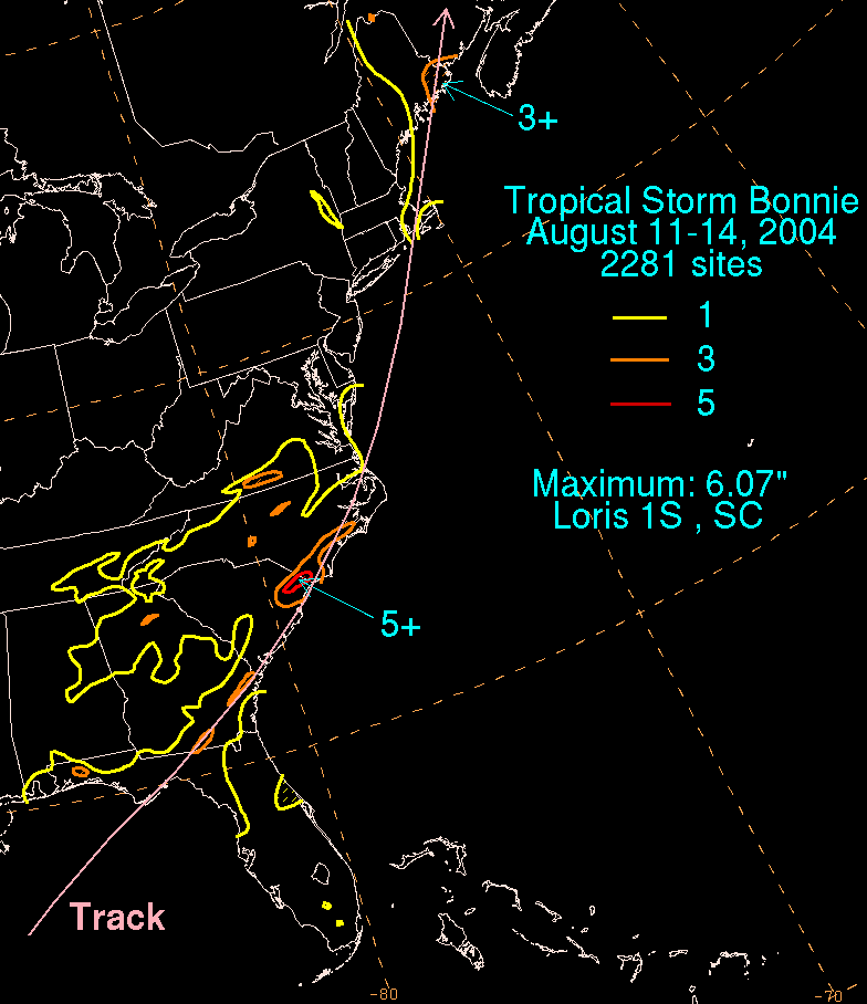
destroyed the roofs of several businesses. In South Carolina, rainfall peaking at 6.07 inches (154 mm) in Loris
Loris, South Carolina
Loris is a city in Horry County, South Carolina, United States. The population was 2,079 at the 2000 census.-Geography:Loris is located at ....
caused flooding across the state. The flooding, including a one foot depth along U.S. Route 501
U.S. Route 501
-North Carolina business loops:-Virginia business loop:-External links:*...
, washed away a road and a bridge in Greenville County
Greenville County, South Carolina
- External Links :*...
. In addition, 600 people across the state were left without electricity.
In Pennsylvania
Pennsylvania
The Commonwealth of Pennsylvania is a U.S. state that is located in the Northeastern and Mid-Atlantic regions of the United States. The state borders Delaware and Maryland to the south, West Virginia to the southwest, Ohio to the west, New York and Ontario, Canada, to the north, and New Jersey to...
, the remnants of the storm dropped up to 8 inches (200 mm) of rain in Tannersville
Tannersville, Pennsylvania
The village of Tannersville, in Pocono Township, Pennsylvania, is the site of the popular Camelback Water Beach & Ski Area. It is in the Eastern Standard time zone. Elevation is . As of 2000, the population of Tannersville was 2,784....
. The rainfall caused the Schuylkill River
Schuylkill River
The Schuylkill River is a river in Pennsylvania. It is a designated Pennsylvania Scenic River.The river is about long. Its watershed of about lies entirely within the state of Pennsylvania. The source of its eastern branch is in the Appalachian Mountains at Tuscarora Springs, near Tamaqua in...
to reach a crest peak of 12.89 ft (4 m) at Berne
Berne, Pennsylvania
Berne is a small unincorporated community in northern Berks County, Pennsylvania. The community is about 3 miles outside of Hamburg, Pennsylvania, and is served by the Hamburg Area School District. Berne sits near the Schuylkill River, south of Blue Mountain, in southeastern Tilden Township....
. The flooding blocked several roads across eastern Pennsylvania. In addition, Bonnie produced gusty winds, leaving thousands without power. In Delaware
Delaware
Delaware is a U.S. state located on the Atlantic Coast in the Mid-Atlantic region of the United States. It is bordered to the south and west by Maryland, and to the north by Pennsylvania...
, the storm dropped up to 4 inches (100 mm) of rain, forcing 100 to evacuate from the floodwaters. The flooding closed part of U.S. Route 13
U.S. Route 13
U.S. Route 13 is a north–south U.S. highway established in 1926 that runs for from Interstate 95 just north of Fayetteville, North Carolina to the northeastern suburbs of Philadelphia, Pennsylvania, in Morrisville. In all, it traverses five states in the Atlantic coastal plain region,...
, and an overflown creek in New Castle County
New Castle County, Delaware
New Castle County is the northernmost of the three counties of the U.S. state of Delaware. As of 2010 its population was 538,479, an increase of 7.6% over the previous decade. The county seat is Wilmington. The center of population of Delaware is located in New Castle County, in the town of...
caused moderate flooding damage to stores. In Maine, moisture from the remnants of Bonnie produced heavy rainfall, with localized totals of up to 10 inches (250 mm). The rainfall flooded or washed out roads across the eastern portion of the state. In Aroostook County
Aroostook County, Maine
Aroostook County is a county located in the U.S. state of Maine. In 2010, its population was 71,870. In land area, it is the largest county in the state and the largest U.S. county east of the Mississippi River. Its seat is Houlton...
, near the town of St. Francis
St. Francis, Maine
St. Francis is a town in Aroostook County, Maine, United States on the Canadian border at the junction of the St. Francis River and the Saint John River. The population was 577 at the 2000 census...
, the rainfall caused a mudslide which narrowed a county road to one lane.
As an extratropical low combined with a frontal system, Bonnie continued to produce moderate rainfall in Canada, peaking at 3.5 inches (90 mm) in Edmundston, New Brunswick
Edmundston, New Brunswick
Edmundston is a Canadian city in Madawaska County, New Brunswick.-History:During the early colonial period, the area was an important meeting place and hunting/fishing spot of the Maliseet nation. A considerable sized village was located there around the turn of the 19th century...
. The rainfall caused basement flooding and road washouts; slick roads caused a traffic fatality in Edmundston.
Aftermath and records
Twenty-two hours after Bonnie struck Florida, Hurricane Charley passed over the Dry TortugasDry Tortugas
The Dry Tortugas are a small group of islands, located at the end of the Florida Keys, USA, about west of Key West, and west of the Marquesas Keys, the closest islands. Still further west is the Tortugas Bank, which is completely submerged. The first Europeans to discover the islands were the...
. This was the first time in recorded history that two tropical storms struck Florida within 1 day. Previously, Hurricane Gordon
Hurricane Gordon (2000)
Hurricane Gordon was one of two U.S. landfalling tropical storms of the 2000 Atlantic hurricane season, and was the 7th named storm and 4th hurricane of the 2000 Atlantic hurricane season. Gordon was a category 1 hurricane over the Gulf of Mexico but weakened to a tropical storm before making...
and Tropical Storm Helene
Tropical Storm Helene (2000)
Tropical Storm Helene was a weak tropical cyclone that made landfall in the United States as a minimal tropical storm. The tropical system was the twelfth tropical cyclone and eighth tropical storm of the 2000 Atlantic hurricane season. After becoming a tropical depression east of the Windward...
struck the state within five days of each other in September 2000. Originally, it was thought that two storms in the 1906 season
1906 Atlantic hurricane season
The 1906 Atlantic hurricane season was the eleventh-deadliest Atlantic hurricane season in recorded history, with 381 deaths. The season was fairly active, with eleven storms, of which six became hurricanes and three became major hurricanes...
hit the state within 12 hours; however, the suspected tropical storm was determined to be a tropical depression in a more recent analysis. Bonnie was the first of five tropical systems to make landfall in Florida during the 2004 Atlantic hurricane season
2004 Atlantic hurricane season
The 2004 Atlantic hurricane season officially began on June 1, 2004, and lasted until November 30, 2004. These dates conventionally delimit the period of each year when most tropical cyclones form in the Atlantic basin...
, and the second of a record eight disturbances to reach tropical storm strength during the month of August.
Because Bonnie hit Florida immediately before Charley, damage between the two storms was often difficult to differentiate. President George W. Bush
George W. Bush
George Walker Bush is an American politician who served as the 43rd President of the United States, from 2001 to 2009. Before that, he was the 46th Governor of Texas, having served from 1995 to 2000....
responded to the storm by declaring much of Florida a Federal Disaster Area on August 13, 2004.
See also
- 2004 Atlantic hurricane season2004 Atlantic hurricane seasonThe 2004 Atlantic hurricane season officially began on June 1, 2004, and lasted until November 30, 2004. These dates conventionally delimit the period of each year when most tropical cyclones form in the Atlantic basin...
- List of Florida hurricanes
- Other tropical cyclones named Bonnie
- Timeline of the 2004 Atlantic hurricane seasonTimeline of the 2004 Atlantic hurricane seasonThe 2004 Atlantic hurricane season was notable as one of the deadliest and most costly Atlantic hurricane seasons on record. It officially began on June 1, 2004 and ended on November 30, although storm activity continued into December. This timeline documents tropical cyclone formations,...
- List of North Carolina hurricanes
- List of New England hurricanes
- List of New Jersey hurricanes