

Northeast U.S. flooding of October 2005
Encyclopedia
Tropical Storm Tammy (2005)
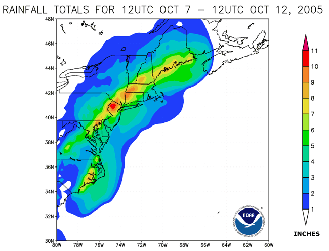
Tropical Storm Tammy was a short lived tropical storm during October in the 2005 Atlantic hurricane season which caused minor damage to the southeastern United States. More significant, however were its remnants which contributed to the Northeast U.S. flooding of October 2005.Tropical Storm Tammy...
and Subtropical Depression Twenty-Two merged with incoming continental cold fronts to produce torrential rains over interior New England
New England
New England is a region in the northeastern corner of the United States consisting of the six states of Maine, New Hampshire, Vermont, Massachusetts, Rhode Island, and Connecticut...
, as well as over parts of New Jersey
New Jersey
New Jersey is a state in the Northeastern and Middle Atlantic regions of the United States. , its population was 8,791,894. It is bordered on the north and east by the state of New York, on the southeast and south by the Atlantic Ocean, on the west by Pennsylvania and on the southwest by Delaware...
and New York
New York
New York is a state in the Northeastern region of the United States. It is the nation's third most populous state. New York is bordered by New Jersey and Pennsylvania to the south, and by Connecticut, Massachusetts and Vermont to the east...
. Particularly hard hit was the state of New Hampshire
New Hampshire
New Hampshire is a state in the New England region of the northeastern United States of America. The state was named after the southern English county of Hampshire. It is bordered by Massachusetts to the south, Vermont to the west, Maine and the Atlantic Ocean to the east, and the Canadian...
, which saw roads and bridges wiped out, several reported deaths, and whole buildings destroyed. Rain lingered over some areas for several weeks. Rainfall from both rain events totaled well over 20 inches (508 mm) in some areas.
Effects by state
Rhode Island
With 14.94 inches (379.5 mm) of rain in October 2005, T. F. Green AirportT. F. Green Airport
T. F. Green Airport , also known as Theodore Francis Green State Airport, is a public airport located in Warwick, six miles south of Providence, in Kent County, Rhode Island, USA. Dedicated in 1931, the airport was named for former Rhode Island governor and longtime senator Theodore F. Green...
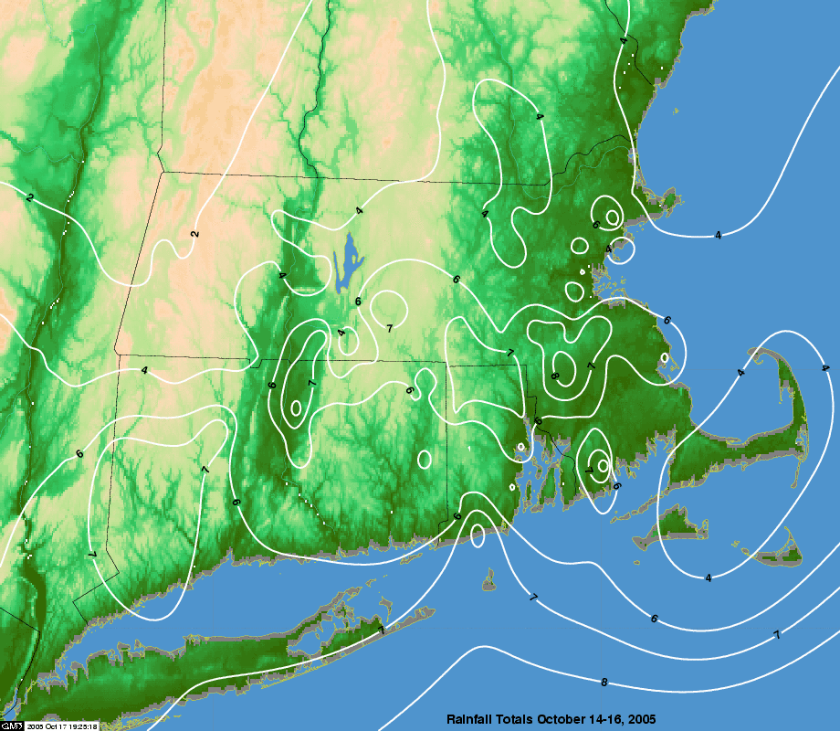
recorded its wettest month ever. During October 13–15, rainfall was heaviest in central and eastern Massachusetts and Rhode Island
Rhode Island
The state of Rhode Island and Providence Plantations, more commonly referred to as Rhode Island , is a state in the New England region of the United States. It is the smallest U.S. state by area...
. The NWS reported rainfall amounts of 4 to 7 inches (100 to 175 mm) in central and eastern Massachusetts and 7 to 9 inches (175 to 225 mm) in Rhode Island. A state of emergency was declared for the state, and thousands were without power. At least 100 residents were evacuated after swift rises in local rivers, and Red Cross shelters were set up throughout the state. The Pawtuxet River
Pawtuxet River
The Pawtuxet River is a river in the U.S. state of Rhode Island. It flows and drains a watershed of . There are four dams along the river's length.-Course:...
, at Cranston
Cranston, Rhode Island
Cranston, once known as Pawtuxet, is a city in Providence County, Rhode Island, United States. With a population of 80,387 at the 2010 census, it is the third largest city in the state. The center of population of Rhode Island is located in Cranston...
and Warwick
Warwick, Rhode Island
Warwick is a city in Kent County, Rhode Island, United States. It is the second largest city in the state, with a population of 82,672 at the 2010 census. Its mayor has been Scott Avedisian since 2000...
, recorded its second-worst flood, at a stage of 13.68 feet (4.17 m). The Blackstone River
Blackstone River
The Blackstone River is a river in the U.S. states of Massachusetts and Rhode Island. It flows approximately 48 mi and drains a watershed of approximately 540 sq. mi...
, at Woonsocket
Woonsocket, Rhode Island
Woonsocket is a city in Providence County, Rhode Island, United States. The population was 41,186 at the 2010 census, making it the sixth largest city in the state. Woonsocket lies directly south of the Massachusetts border....
, also recorded its second-worst flood, at a stage of 15.34 feet (4.68 m). The Woonasquatucket River
Woonasquatucket River
The Woonasquatucket River is a river in the U.S. state of Rhode Island. It flows approximately and drains a watershed of 130 km² ....
in Providence
Providence, Rhode Island
Providence is the capital and most populous city of Rhode Island and was one of the first cities established in the United States. Located in Providence County, it is the third largest city in the New England region...
and Central Falls
Central Falls, Rhode Island
Central Falls is a city in Providence County, Rhode Island, United States. The population was 19,376 at the 2010 census. With an area of only , it is the smallest and most densely populated city in the smallest state, and the thirty-second most densely populated incorporated place in the United...
recorded a new flood record, at 8.3 feet (2.53 m). Damage in Rhode Island totaled $1.6 million (2005 USD).
Connecticut
Thousands of homes and businesses lost power, primarily in BridgeportBridgeport, Connecticut
Bridgeport is the most populous city in the U.S. state of Connecticut. Located in Fairfield County, the city had an estimated population of 144,229 at the 2010 United States Census and is the core of the Greater Bridgeport area...
. Localized flooding was reported in certain areas of Connecticut
Connecticut
Connecticut is a state in the New England region of the northeastern United States. It is bordered by Rhode Island to the east, Massachusetts to the north, and the state of New York to the west and the south .Connecticut is named for the Connecticut River, the major U.S. river that approximately...
: one death occurred when a woman was swept away at Diana's Pool on the Natchaug River
Natchaug River
The Natchaug River is a river in Windham and Tolland Counties in Connecticut.The Natchaug River is formed in Eastford, Connecticut at the confluence of Bigelow Brook and the Still River. It then flows to the south, paralleling Connecticut Route 198. The river also runs along the western border...
, and another woman fell into the churning Connecticut River
Connecticut River
The Connecticut River is the largest and longest river in New England, and also an American Heritage River. It flows roughly south, starting from the Fourth Connecticut Lake in New Hampshire. After flowing through the remaining Connecticut Lakes and Lake Francis, it defines the border between the...
. In addition, the rains softened the soil
Soil
Soil is a natural body consisting of layers of mineral constituents of variable thicknesses, which differ from the parent materials in their morphological, physical, chemical, and mineralogical characteristics...
, creating mudslides that damaged a lengthy stretch of railroad tracks near Naugatuck
Naugatuck, Connecticut
Naugatuck is a consolidated borough and town in New Haven County, Connecticut, United States. The town spans both sides of the Naugatuck River just south of Waterbury, and includes the communities of Union City on the east side of the river, which has its own post office, Straitsville on the...
, interrupting service. Residents in low-lying areas of Shelton
Shelton, Connecticut
Shelton is a city in Fairfield County, Connecticut, United States. The population was 39,559 at the 2010 census.-Origins:Shelton was settled by the English as part of the town of Stratford, Connecticut, in 1639...
, Seymour
Seymour, Connecticut
Seymour is a town located in western New Haven County, Connecticut, United States. The town was named for Governor Thomas H. Seymour. The population was 15,454 at the 2000 census.-Geography:...
, Stratford
Stratford, Connecticut
Stratford is a town in Fairfield County, Connecticut, United States, located on Long Island Sound at the mouth of the Housatonic River. It was founded by Puritans in 1639....
, and Oxford
Oxford, Connecticut
Oxford is a town located in western New Haven County, Connecticut, United States. The population was 12,272 at the 2010 Census. There are several areas in Oxford: Quaker Farms, Riverside and Oxford Center. Oxford belongs to the Naugatuck Valley Economic Development Region and the Central...
were evacuated as heavy rains forced the Housatonic River
Housatonic River
The Housatonic River is a river, approximately long, in western Massachusetts and western Connecticut in the United States. It flows south to southeast, and drains about of southwestern New England into Long Island Sound...
out of its banks, inundating homes and businesses. It was the wettest October on record for Hartford
Hartford, Connecticut
Hartford is the capital of the U.S. state of Connecticut. The seat of Hartford County until Connecticut disbanded county government in 1960, it is the second most populous city on New England's largest river, the Connecticut River. As of the 2010 Census, Hartford's population was 124,775, making...
. Damage totaled to $6 million (2005 USD).
Massachusetts
Severe inland flooding resulted in $6.5 million in damage. In GreenfieldGreenfield, Massachusetts
Greenfield is a city in Franklin County, Massachusetts, United States. The population was 17,456 at the 2010 census. It is the county seat of Franklin County. Greenfield is home to Greenfield Community College, the Pioneer Valley Symphony Orchestra, and the Franklin County Fair...
, a trailer park
Trailer park
A trailer park is a semi-permanent or permanent area for mobile homes or travel trailers. The main reasons for living in such trailer parks are the often lower cost compared to other housing, and the ability to move to a new area more quickly and easily, for example when changing jobs to another...
was destroyed, leaving at least 70 people homeless. Officials evacuated 2,000 residents of Taunton
Taunton, Massachusetts
Taunton is a city in Bristol County, Massachusetts, United States. It is the seat of Bristol County and the hub of the Greater Taunton Area. The city is located south of Boston, east of Providence, north of Fall River and west of Plymouth. The City of Taunton is situated on the Taunton River...
when the failing Whittenton Pond Dam
Whittenton Pond Dam
Whittenton Pond Dam or Whittenton Street Dam is a private earthen dam across the Mill River in Taunton, Massachusetts.Built in 1832, the original dam was a half-mile upstream from downtown Taunton. It was 12 feet high and constructed of timber...
threatened to collapse and submerge the city under 8 feet (2.44 meters) of water. The Massachusetts National Guard
Massachusetts National Guard
The Massachusetts National Guard was founded as the Massachusetts Bay Colonial Militia on December 13, 1636, and contains the oldest units in the United States Army. It is currently headquartered in Milford, Massachusetts and commanded by Major General Joseph C...
drained the reservoir behind the 173-year wooden dam using five high-volume pumps. Once the reservoir was drained, evacuees were allowed to return to their homes, and the Army Corps of Engineers removed the old structure and replaced it with an earthen dam.
New Hampshire
The state of New HampshireNew Hampshire
New Hampshire is a state in the New England region of the northeastern United States of America. The state was named after the southern English county of Hampshire. It is bordered by Massachusetts to the south, Vermont to the west, Maine and the Atlantic Ocean to the east, and the Canadian...
was one of the hardest hit from flooding and mudslides, particularly in the southwestern part. The town of Alstead
Alstead, New Hampshire
Alstead is a town in Cheshire County, New Hampshire, United States. The population was 1,937 at the 2010 census. Alstead is home to Feuer State Forest.-History:...
was especially hard hit, as the Cold River
Cold River (Connecticut River)
The Cold River is a 22.6 mile long river located in western New Hampshire in the United States. It is a tributary of the Connecticut River, which flows to Long Island Sound....
and its tributaries substantially overflowed due to the heavy rain and water flowing downstream, inundating the community. The city of Keene
Keene, New Hampshire
Keene is a city in Cheshire County, New Hampshire, United States. The population was 23,409 at the 2010 census. It is the county seat of Cheshire County.Keene is home to Keene State College and Antioch University New England, and hosts the annual Pumpkin Fest...
received over 14 inches (35.6 cm) of rain, flooding communities near Beaver Brook and the lower Ashuelot River
Ashuelot River
The Ashuelot River is a tributary of the Connecticut River, approximately long, in southwestern New Hampshire in the United States. It drains a mountainous area of , including much of the area known as the Monadnock Region...
. More than 1,000 people were forced to evacuate their homes in the region. Seven deaths were confirmed in the state. In some areas, entire houses were washed off of their foundations. Damages totaled $15.8 million (2005 USD), primarily in Cheshire County
Cheshire County, New Hampshire
-Demographics:As of the census of 2000, there were 73,825 people, 28,299 households, and 18,790 families residing in the county. The population density was 104 people per square mile . There were 31,876 housing units at an average density of 45 per square mile...
. The storm dropped nearly 18 inches (45.7 cm) of liquid precipitation, including nearly 3 feet (914.4 mm) of snow
Snow
Snow is a form of precipitation within the Earth's atmosphere in the form of crystalline water ice, consisting of a multitude of snowflakes that fall from clouds. Since snow is composed of small ice particles, it is a granular material. It has an open and therefore soft structure, unless packed by...
on the summit of Mount Washington
Mount Washington (New Hampshire)
Mount Washington is the highest peak in the Northeastern United States at , famous for dangerously erratic weather. For 76 years, a weather observatory on the summit held the record for the highest wind gust directly measured at the Earth's surface, , on the afternoon of April 12, 1934...
, as recorded by the Mount Washington Observatory
Mount Washington Observatory
The Mount Washington Observatory is a private, non-profit scientific and educational institution organized under the laws of the state of New Hampshire. The weather observation station is located on the summit of Mount Washington in New Hampshire...
. This contributed to a record-setting month on the peak with "the world's worst weather," which recorded 28.7 inches (72.9 cm) of rain, a record for any month since 1934, and 78.9 inches (200.4 cm) of snow, a record for the month of October.
New Jersey
Flooding was reported in several parts of northern New JerseyNew Jersey
New Jersey is a state in the Northeastern and Middle Atlantic regions of the United States. , its population was 8,791,894. It is bordered on the north and east by the state of New York, on the southeast and south by the Atlantic Ocean, on the west by Pennsylvania and on the southwest by Delaware...
. Bergen
Bergen County, New Jersey
Bergen County is the most populous county of the state of New Jersey, United States. As of the 2010 United States Census, its population was 905,116. The county is part of the New York City Metropolitan Area. Its county seat is Hackensack...
and Passaic
Passaic County, New Jersey
Passaic County is a county located in the U.S. state of New Jersey. As of the 2010 Census, the population was 501,226. Its county seat is Paterson...
counties were hardest hit, as floodwaters covered several communities to varying degrees. In most places, flooding was the worst seen since 1999's Hurricane Floyd
Hurricane Floyd
Hurricane Floyd was the sixth named storm, fourth hurricane, and third major hurricane in the 1999 Atlantic hurricane season. Floyd triggered the third largest evacuation in US history when 2.6 million coastal residents of five states were ordered from their homes as it approached...
.
Several rivers, including the Pequannock River
Pequannock River
The Pequannock River is a tributary of the Pompton River, approximately 20 miles long, located in northern New Jersey in the United States....
, Passaic River
Passaic River
The Passaic River is a mature surface river, approximately 80 mi long, in northern New Jersey in the United States. The river in its upper course flows in a highly circuitous route, meandering through the swamp lowlands between the ridge hills of rural and suburban northern New Jersey,...
and Ramapo River
Ramapo River
The Ramapo River is a tributary of the Pompton River, approximately 30 mi long, in southern New York and northern New Jersey in the United States.-Course:...
, overflowed their banks. Evacuation orders were issued for parts of the towns of Bound Brook
Bound Brook, New Jersey
Bound Brook is a borough in Somerset County, New Jersey, United States. At the United States 2010 Census, the population was 10,402.Bound Brook was originally incorporated as a town by an Act of the New Jersey Legislature on March 24, 1869, within portions of Bridgewater Township...
, Lodi
Lodi, New Jersey
Lodi is a borough in Bergen County, New Jersey, United States. As of the 2010 United States Census, the borough population was 24,136. The borough of Lodi is governed under the 1923 Municipal Manager Law.Lodi owes its name to the Italian city of Lodi...
, Oakland
Oakland, New Jersey
Oakland is a borough in Bergen County, New Jersey, United States. As of the 2010 United States Census, the borough population was 12,754.Oakland was incorporated as a borough by an Act of the New Jersey Legislature on April 8, 1902, from portions of Franklin Township.-History:The Van Allen House...
and Westwood
Westwood, New Jersey
Westwood is a borough in Bergen County, New Jersey, United States. As of the 2010 United States Census, the borough population was 10,908....
during the peak of the flooding. Coastal flooding was also reported along parts of the Jersey Shore
Jersey Shore
The Jersey Shore is a term used to refer to both the Atlantic coast of the U.S. state of New Jersey and the adjacent resort and residential communities. . The New Jersey State Department of Tourism considers the Shore Region, Greater Atlantic City, and the Southern Shore to be distinct, each having...
. A statewide state of emergency
State of emergency
A state of emergency is a governmental declaration that may suspend some normal functions of the executive, legislative and judicial powers, alert citizens to change their normal behaviours, or order government agencies to implement emergency preparedness plans. It can also be used as a rationale...
was declared by Governor
Governor of New Jersey
The Office of the Governor of New Jersey is the executive branch for the U.S. state of New Jersey. The office of Governor is an elected position, for which elected officials serve four year terms. While individual politicians may serve as many terms as they can be elected to, Governors cannot be...
Richard Codey
Richard Codey
Richard James Codey is an American Democratic Party politician who served as the 53rd Governor of New Jersey from November 2004 to January 2006. He has served in the New Jersey Senate since 1981 and served as the President of the Senate from 2002 to January 2010. He represents the 27th Legislative...
.
New York
Coastal flooding was a problem on Long IslandLong Island
Long Island is an island located in the southeast part of the U.S. state of New York, just east of Manhattan. Stretching northeast into the Atlantic Ocean, Long Island contains four counties, two of which are boroughs of New York City , and two of which are mainly suburban...
, and severe beach erosion
Erosion
Erosion is when materials are removed from the surface and changed into something else. It only works by hydraulic actions and transport of solids in the natural environment, and leads to the deposition of these materials elsewhere...
was reported in many areas. It was the wettest October on record for Central Park
Central Park
Central Park is a public park in the center of Manhattan in New York City, United States. The park initially opened in 1857, on of city-owned land. In 1858, Frederick Law Olmsted and Calvert Vaux won a design competition to improve and expand the park with a plan they entitled the Greensward Plan...
.
Maine
Minor to moderate flooding occurred across the southern half of the state, in such cities as PortlandPortland, Maine
Portland is the largest city in Maine and is the county seat of Cumberland County. The 2010 city population was 66,194, growing 3 percent since the census of 2000...
, Bar Harbor
Bar Harbor, Maine
Bar Harbor is a town on Mount Desert Island in Hancock County, Maine, United States. As of the 2010 census, its population is 5,235. Bar Harbor is a famous summer colony in the Down East region of Maine. It is home to the College of the Atlantic, Jackson Laboratory and Mount Desert Island...
, and Bangor
Bangor, Maine
Bangor is a city in and the county seat of Penobscot County, Maine, United States, and the major commercial and cultural center for eastern and northern Maine...
. In Bangor, a total of 13.32 inches (338 mm) of rain was measured during the month, making it the rainiest month in history.
External links
- The HPCHydrometeorological Prediction CenterThe Hydrometeorological Prediction Center is one of nine service centers under the umbrella of the National Centers for Environmental Prediction , a part of the National Weather Service, which in turn is part of the National Oceanic and Atmospheric Administration of the U.S. government...
archive for the first event. - The HPC archive for the second event.