
1903 Vagabond hurricane
Encyclopedia
The 1903 New Jersey hurricane, also known as the Vagabond Hurricane by The Press of Atlantic City
, is the second most recent Atlantic hurricane
to make first landfall in the state
of New Jersey
, preceding Hurricane Irene. The fourth hurricane of the season, the cyclone was first observed on September 12 about 550 miles (885 km) northeast of Antigua
. It moved quickly westward, then later turned to the north-northwest, steadily strengthening to reach a peak intensity of 100 mph (155 km/h). The hurricane weakened slightly before striking near Atlantic City, New Jersey
on September 16 with winds of 80 mph (130 km/h). It weakened over Pennsylvania
and became an extratropical cyclone
over western New York
on September 17.
Rough surf and moderate winds from the hurricane capsized several ships along the East Coast of the United States
; 30 people were left missing and presumed killed from a shipwreck in Chincoteague, Virginia
. In New Jersey
, the hurricane caused heavy damage, particularly near the coast. Dozens of buildings were damaged or destroyed, and damage across the state totalled $8 million (1903 USD, $180 million 2006 USD). On Long Island
, President
Theodore Roosevelt
directly experienced the effects of the hurricane while on a yacht. The life of the president was briefly threatened by the rough conditions, though none on board the yacht suffered any problems from the hurricane.
in the Lesser Antilles
. The storm tracked quickly northwestward, followed by a turn to the west-northwest; at 1800 UTC on September 13 the storm passed about 270 miles (435 km) south of Bermuda
. Its exact track and intensity is unknown, though it is estimated the storm attained hurricane status late on September 14 about 360 miles (580 km) west-southwest of Bermuda. Under generally favorable conditions, the hurricane steadily intensified as it curved northward, and attained its peak intensity of 100 mph (155 km/h) late on September 15 while located about 110 miles (190 km) southeast of Cape Hatteras
, North Carolina
.
Operationally, the hurricane was first classified on the evening of September 15, based on ship reports. Strong winds were also reported along coastal areas of the Mid-Atlantic
, and the United States
National Weather Bureau issued storm warnings
on the morning of September 16 through September 17. The hurricane continued quickly northward, and made landfall
near Atlantic City, New Jersey
shortly before 1200 UTC on September 16 with winds of 80 mph (130 km/h). An area of convection in association with the hurricane continued north-northeastward, and operationally meteorologists estimated the center tracked into Connecticut
. However, post-analysis indicates the center of the hurricane continued northwestward, weakened into a tropical storm near Trenton
, and after crossing northeastern Pennsylvania
transitioned into an extratropical cyclone
near Syracuse, New York
. The extratropical remnant persisted for another 6 hours before losing its identity over eastern Ontario
.
 Strong winds were reported along coastal areas of North Carolina
, with sustained winds peaking at 72 mph (116 km/h) at Kitty Hawk
. Winds reached 54 mph (87 km/h) at Cape Henry
, Virginia
, and the combination of the winds and rough surf washed some boats ashore. A schooner was lost near Chincoteague
, with its crew of 30 missing and presumed killed. A squall line
destroyed the front mast
of a schooner near Cape Henry, as well. A flock of birds encountered the hurricane over eastern Virginia; hundreds of birds were killed and fell to the ground near Old Point Comfort, many of which were stripped of their feathers. The outer rainband
s of the storm produced heavy amounts of precipitation near Washington, D.C.
, canceling a baseball game between the Detroit Tigers
and the Washington Senators
.
In Ocean City, Maryland
, the hurricane was considered the worst in 40 years. Several schooners broke free from their moorings near Salisbury
and were subsequently destroyed after passing downstream. The hurricane produced 80 mph (130 km/h) winds and rough waves along the Delaware Capes. One schooner along the Delaware coastline was destroyed after hitting the rocky coastline; its crew of 5 were killed. Three barges and a steamer capsized in the Delaware Bay
, while onshore, the winds of the hurricane destroyed the roofs of 4 houses in Laurel
. The winds downed many trees and destroyed several chimneys near Lewes
.
Hurricane force winds occurred across coastal areas of South Jersey
, one of only two hurricanes to produce hurricane force winds in the state. The storm's strong surf destroyed several boats along the coastline, including 34 in Waretown
. The surf damaged or destroyed most fishing piers and oceanfront pavilions in the Atlantic City
area, with tons of debris dispersed across the beach. Strong winds from the hurricane downed all telephone and telegraph wires across the coastal region, with initial damage reports provided by trains. Additionally, the winds destroyed the roofs of an estimated 50 to 60 cottages. The strong winds, combined with heavy rainfall, resulted in one indirect fatality when a man, unable to see owing to the hurricane, drove into a train in Cape May
. At least 2 houses were destroyed in Atlantic City. Several streets were flooded, with severe transportation delays reported. Damage across the state was estimated at $8 million (1903 USD, $180 million 2006 USD); the worst of the damage occurred in Atlantic City, though moderate damage extended from Cape May northward through Asbury Park
.
In Philadelphia, Pennsylvania, strong winds from the hurricane downed several trees, and also damaged a train station along Broad Street
.
President
Theodore Roosevelt
directly experienced the effects of the hurricane while vacationing on a yacht along Long Island
. The yacht experienced gusty winds and heavy rainfall, along with rough seas. After the President was considered to be in danger, the yacht headed for land, and instead of embarking toward Ellis Island
as originally planned, the yacht approached Brooklyn Navy Yard
. No one onboard was injured. Rough waves sunk or severely damaged dozens of boats across coastal areas of New York, leaving dozens injured. Winds in New York City
reached 65 mph (105 km/h), with tropical storm force winds extending into Maine
. The outer moisture of the hurricane dropped 2.4 inches (61 mm) of rain in Central Park
, with its gusty winds causing damage to suburban houses and signs. The winds downed some trees and power lines, resulting in some power outages. The hurricane also left businesses and the stock market quiet for the day, owing to the threat of blowing debris.
The Press of Atlantic City
The Press of Atlantic City is a daily newspaper based in Pleasantville, New Jersey. It is the primary newspaper for most of southeastern New Jersey and the Jersey Shore, publishing regional editions for Atlantic County, Cumberland County, Cape May County, and southern Ocean County...
, is the second most recent Atlantic hurricane
Atlantic hurricane
North Atlantic tropical cyclones usually form in the northern hemisphere summer or fall. Tropical cyclones can be categorized by intensity. Tropical storms have one-minute maximum sustained winds of at least 39 mph , while hurricanes have one-minute maximum sustained exceeding 74 mph...
to make first landfall in the state
U.S. state
A U.S. state is any one of the 50 federated states of the United States of America that share sovereignty with the federal government. Because of this shared sovereignty, an American is a citizen both of the federal entity and of his or her state of domicile. Four states use the official title of...
of New Jersey
New Jersey
New Jersey is a state in the Northeastern and Middle Atlantic regions of the United States. , its population was 8,791,894. It is bordered on the north and east by the state of New York, on the southeast and south by the Atlantic Ocean, on the west by Pennsylvania and on the southwest by Delaware...
, preceding Hurricane Irene. The fourth hurricane of the season, the cyclone was first observed on September 12 about 550 miles (885 km) northeast of Antigua
Antigua
Antigua , also known as Waladli, is an island in the West Indies, in the Leeward Islands in the Caribbean region, the main island of the country of Antigua and Barbuda. Antigua means "ancient" in Spanish and was named by Christopher Columbus after an icon in Seville Cathedral, Santa Maria de la...
. It moved quickly westward, then later turned to the north-northwest, steadily strengthening to reach a peak intensity of 100 mph (155 km/h). The hurricane weakened slightly before striking near Atlantic City, New Jersey
Atlantic City, New Jersey
Atlantic City is a city in Atlantic County, New Jersey, United States, and a nationally renowned resort city for gambling, shopping and fine dining. The city also served as the inspiration for the American version of the board game Monopoly. Atlantic City is located on Absecon Island on the coast...
on September 16 with winds of 80 mph (130 km/h). It weakened over Pennsylvania
Pennsylvania
The Commonwealth of Pennsylvania is a U.S. state that is located in the Northeastern and Mid-Atlantic regions of the United States. The state borders Delaware and Maryland to the south, West Virginia to the southwest, Ohio to the west, New York and Ontario, Canada, to the north, and New Jersey to...
and became an extratropical cyclone
Extratropical cyclone
Extratropical cyclones, sometimes called mid-latitude cyclones or wave cyclones, are a group of cyclones defined as synoptic scale low pressure weather systems that occur in the middle latitudes of the Earth having neither tropical nor polar characteristics, and are connected with fronts and...
over western New York
New York
New York is a state in the Northeastern region of the United States. It is the nation's third most populous state. New York is bordered by New Jersey and Pennsylvania to the south, and by Connecticut, Massachusetts and Vermont to the east...
on September 17.
Rough surf and moderate winds from the hurricane capsized several ships along the East Coast of the United States
East Coast of the United States
The East Coast of the United States, also known as the Eastern Seaboard, refers to the easternmost coastal states in the United States, which touch the Atlantic Ocean and stretch up to Canada. The term includes the U.S...
; 30 people were left missing and presumed killed from a shipwreck in Chincoteague, Virginia
Chincoteague, Virginia
Chincoteague is a town on Chincoteague Island in Accomack County, Virginia, United States. The population was 4,317 at the 2000 census. The town is perhaps best known for the Chincoteague Ponies, although these are not actually on the island of Chincoteague but on nearby Assateague Island...
. In New Jersey
New Jersey
New Jersey is a state in the Northeastern and Middle Atlantic regions of the United States. , its population was 8,791,894. It is bordered on the north and east by the state of New York, on the southeast and south by the Atlantic Ocean, on the west by Pennsylvania and on the southwest by Delaware...
, the hurricane caused heavy damage, particularly near the coast. Dozens of buildings were damaged or destroyed, and damage across the state totalled $8 million (1903 USD, $180 million 2006 USD). On Long Island
Long Island
Long Island is an island located in the southeast part of the U.S. state of New York, just east of Manhattan. Stretching northeast into the Atlantic Ocean, Long Island contains four counties, two of which are boroughs of New York City , and two of which are mainly suburban...
, President
President of the United States
The President of the United States of America is the head of state and head of government of the United States. The president leads the executive branch of the federal government and is the commander-in-chief of the United States Armed Forces....
Theodore Roosevelt
Theodore Roosevelt
Theodore "Teddy" Roosevelt was the 26th President of the United States . He is noted for his exuberant personality, range of interests and achievements, and his leadership of the Progressive Movement, as well as his "cowboy" persona and robust masculinity...
directly experienced the effects of the hurricane while on a yacht. The life of the president was briefly threatened by the rough conditions, though none on board the yacht suffered any problems from the hurricane.
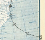
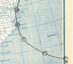
Meteorological history
The genesis of the storm is unknown; it was first observed on September 12 as a 70 mph (120 km/h) tropical storm while located about 550 miles (885 km) northeast of AntiguaAntigua
Antigua , also known as Waladli, is an island in the West Indies, in the Leeward Islands in the Caribbean region, the main island of the country of Antigua and Barbuda. Antigua means "ancient" in Spanish and was named by Christopher Columbus after an icon in Seville Cathedral, Santa Maria de la...
in the Lesser Antilles
Lesser Antilles
The Lesser Antilles are a long, partly volcanic island arc in the Western Hemisphere. Most of its islands form the eastern boundary of the Caribbean Sea with the Atlantic Ocean, with the remainder located in the southern Caribbean just north of South America...
. The storm tracked quickly northwestward, followed by a turn to the west-northwest; at 1800 UTC on September 13 the storm passed about 270 miles (435 km) south of Bermuda
Bermuda
Bermuda is a British overseas territory in the North Atlantic Ocean. Located off the east coast of the United States, its nearest landmass is Cape Hatteras, North Carolina, about to the west-northwest. It is about south of Halifax, Nova Scotia, Canada, and northeast of Miami, Florida...
. Its exact track and intensity is unknown, though it is estimated the storm attained hurricane status late on September 14 about 360 miles (580 km) west-southwest of Bermuda. Under generally favorable conditions, the hurricane steadily intensified as it curved northward, and attained its peak intensity of 100 mph (155 km/h) late on September 15 while located about 110 miles (190 km) southeast of Cape Hatteras
Cape Hatteras
Cape Hatteras is a cape on the coast of North Carolina. It is the point that protrudes the farthest to the southeast along the northeast-to-southwest line of the Atlantic coast of North America...
, North Carolina
North Carolina
North Carolina is a state located in the southeastern United States. The state borders South Carolina and Georgia to the south, Tennessee to the west and Virginia to the north. North Carolina contains 100 counties. Its capital is Raleigh, and its largest city is Charlotte...
.
Operationally, the hurricane was first classified on the evening of September 15, based on ship reports. Strong winds were also reported along coastal areas of the Mid-Atlantic
Mid-Atlantic States
The Mid-Atlantic states, also called middle Atlantic states or simply the mid Atlantic, form a region of the United States generally located between New England and the South...
, and the United States
United States
The United States of America is a federal constitutional republic comprising fifty states and a federal district...
National Weather Bureau issued storm warnings
Tropical cyclone warnings and watches
Warnings and watches are two levels of alert issued by national weather forecasting bodies to coastal areas threatened by the imminent approach of a tropical cyclone of tropical storm or hurricane intensity. They are notices to the local population and civil authorities to make appropriate...
on the morning of September 16 through September 17. The hurricane continued quickly northward, and made landfall
Landfall (meteorology)
Landfall is the event of a tropical cyclone or a waterspout coming onto land after being over water. When a waterspout makes landfall it is reclassified as a tornado, which can then cause damage inland...
near Atlantic City, New Jersey
Atlantic City, New Jersey
Atlantic City is a city in Atlantic County, New Jersey, United States, and a nationally renowned resort city for gambling, shopping and fine dining. The city also served as the inspiration for the American version of the board game Monopoly. Atlantic City is located on Absecon Island on the coast...
shortly before 1200 UTC on September 16 with winds of 80 mph (130 km/h). An area of convection in association with the hurricane continued north-northeastward, and operationally meteorologists estimated the center tracked into Connecticut
Connecticut
Connecticut is a state in the New England region of the northeastern United States. It is bordered by Rhode Island to the east, Massachusetts to the north, and the state of New York to the west and the south .Connecticut is named for the Connecticut River, the major U.S. river that approximately...
. However, post-analysis indicates the center of the hurricane continued northwestward, weakened into a tropical storm near Trenton
Trenton, New Jersey
Trenton is the capital of the U.S. state of New Jersey and the county seat of Mercer County. As of the 2010 United States Census, Trenton had a population of 84,913...
, and after crossing northeastern Pennsylvania
Pennsylvania
The Commonwealth of Pennsylvania is a U.S. state that is located in the Northeastern and Mid-Atlantic regions of the United States. The state borders Delaware and Maryland to the south, West Virginia to the southwest, Ohio to the west, New York and Ontario, Canada, to the north, and New Jersey to...
transitioned into an extratropical cyclone
Extratropical cyclone
Extratropical cyclones, sometimes called mid-latitude cyclones or wave cyclones, are a group of cyclones defined as synoptic scale low pressure weather systems that occur in the middle latitudes of the Earth having neither tropical nor polar characteristics, and are connected with fronts and...
near Syracuse, New York
Syracuse, New York
Syracuse is a city in and the county seat of Onondaga County, New York, United States, the largest U.S. city with the name "Syracuse", and the fifth most populous city in the state. At the 2010 census, the city population was 145,170, and its metropolitan area had a population of 742,603...
. The extratropical remnant persisted for another 6 hours before losing its identity over eastern Ontario
Ontario
Ontario is a province of Canada, located in east-central Canada. It is Canada's most populous province and second largest in total area. It is home to the nation's most populous city, Toronto, and the nation's capital, Ottawa....
.
Impact
North Carolina
North Carolina is a state located in the southeastern United States. The state borders South Carolina and Georgia to the south, Tennessee to the west and Virginia to the north. North Carolina contains 100 counties. Its capital is Raleigh, and its largest city is Charlotte...
, with sustained winds peaking at 72 mph (116 km/h) at Kitty Hawk
Kitty Hawk, North Carolina
Kitty Hawk is a town in Dare County, North Carolina, United States. The population was 3,000 at the 2000 census. It was established in the early 18th century as Chickahawk....
. Winds reached 54 mph (87 km/h) at Cape Henry
Cape Henry
Cape Henry is a cape on the Atlantic shore of Virginia north of Virginia Beach. It is the southern boundary of the entrance to Chesapeake Bay.Across the mouth of the bay to the north is Cape Charles...
, Virginia
Virginia
The Commonwealth of Virginia , is a U.S. state on the Atlantic Coast of the Southern United States. Virginia is nicknamed the "Old Dominion" and sometimes the "Mother of Presidents" after the eight U.S. presidents born there...
, and the combination of the winds and rough surf washed some boats ashore. A schooner was lost near Chincoteague
Chincoteague, Virginia
Chincoteague is a town on Chincoteague Island in Accomack County, Virginia, United States. The population was 4,317 at the 2000 census. The town is perhaps best known for the Chincoteague Ponies, although these are not actually on the island of Chincoteague but on nearby Assateague Island...
, with its crew of 30 missing and presumed killed. A squall line
Squall line
A squall line is a line of severe thunderstorms that can form along or ahead of a cold front. In the early 20th century, the term was used as a synonym for cold front. It contains heavy precipitation, hail, frequent lightning, strong straight-line winds, and possibly tornadoes and waterspouts....
destroyed the front mast
Mast (sailing)
The mast of a sailing vessel is a tall, vertical, or near vertical, spar, or arrangement of spars, which supports the sails. Large ships have several masts, with the size and configuration depending on the style of ship...
of a schooner near Cape Henry, as well. A flock of birds encountered the hurricane over eastern Virginia; hundreds of birds were killed and fell to the ground near Old Point Comfort, many of which were stripped of their feathers. The outer rainband
Rainband
A rainband is a cloud and precipitation structure associated with an area of rainfall which is significantly elongated. Rainbands can be stratiform or convective, and are generated by differences in temperature. When noted on weather radar imagery, this precipitation elongation is referred to as...
s of the storm produced heavy amounts of precipitation near Washington, D.C.
Washington, D.C.
Washington, D.C., formally the District of Columbia and commonly referred to as Washington, "the District", or simply D.C., is the capital of the United States. On July 16, 1790, the United States Congress approved the creation of a permanent national capital as permitted by the U.S. Constitution....
, canceling a baseball game between the Detroit Tigers
Detroit Tigers
The Detroit Tigers are a Major League Baseball team located in Detroit, Michigan. One of the American League's eight charter franchises, the club was founded in Detroit in as part of the Western League. The Tigers have won four World Series championships and have won the American League pennant...
and the Washington Senators
Minnesota Twins
The Minnesota Twins are a professional baseball team based in Minneapolis, Minnesota. They play in the Central Division of Major League Baseball's American League. The team is named after the Twin Cities area of Minneapolis and St. Paul. They played in Metropolitan Stadium from 1961 to 1981 and the...
.
In Ocean City, Maryland
Ocean City, Maryland
Ocean City, sometimes known as OC, or OCMD, is an Atlantic Ocean resort town in Worcester County, Maryland, United States. Ocean City is widely known in the Mid-Atlantic region of the United States and is a frequent destination for vacationers in that area...
, the hurricane was considered the worst in 40 years. Several schooners broke free from their moorings near Salisbury
Salisbury, Maryland
-Demographics:Salisbury is the principal city of the Salisbury-Ocean Pines CSA, a Combined Statistical Area that includes the Salisbury metropolitan area and the Ocean Pines micropolitan area , which had a combined population of 176,657 at the 2010 census.As of the census of 2000, there were...
and were subsequently destroyed after passing downstream. The hurricane produced 80 mph (130 km/h) winds and rough waves along the Delaware Capes. One schooner along the Delaware coastline was destroyed after hitting the rocky coastline; its crew of 5 were killed. Three barges and a steamer capsized in the Delaware Bay
Delaware Bay
Delaware Bay is a major estuary outlet of the Delaware River on the Northeast seaboard of the United States whose fresh water mixes for many miles with the waters of the Atlantic Ocean. It is in area. The bay is bordered by the State of New Jersey and the State of Delaware...
, while onshore, the winds of the hurricane destroyed the roofs of 4 houses in Laurel
Laurel, Delaware
As of the census of 2000, there were 3,668 people, 1,389 households, and 957 families residing in the town. The population density was 2,215.9 people per square mile . There were 1,561 housing units at an average density of 943.0 per square mile...
. The winds downed many trees and destroyed several chimneys near Lewes
Lewes, Delaware
Lewes is an incorporated city in Sussex County, Delaware, USA, on the Delmarva Peninsula. According to the 2010 census, the population is 2,747, a decrease of 6.3% from 2000....
.
Hurricane force winds occurred across coastal areas of South Jersey
South Jersey
South Jersey comprises the southern portions of the U.S. state of New Jersey between the lower Delaware River and the Atlantic Ocean. The designation is a colloquial one, reflecting not only geographical but perceived cultural differences from the northern part of the state, with no official...
, one of only two hurricanes to produce hurricane force winds in the state. The storm's strong surf destroyed several boats along the coastline, including 34 in Waretown
Waretown, New Jersey
Waretown is a census-designated place and unincorporated area located within Ocean Township, in Ocean County, New Jersey. As of the United States 2000 Census, the CDP population was 1,582. Waretown is home to Albert Music Hall and 2009 Nobel Prize winner in Physics, George E...
. The surf damaged or destroyed most fishing piers and oceanfront pavilions in the Atlantic City
Atlantic City, New Jersey
Atlantic City is a city in Atlantic County, New Jersey, United States, and a nationally renowned resort city for gambling, shopping and fine dining. The city also served as the inspiration for the American version of the board game Monopoly. Atlantic City is located on Absecon Island on the coast...
area, with tons of debris dispersed across the beach. Strong winds from the hurricane downed all telephone and telegraph wires across the coastal region, with initial damage reports provided by trains. Additionally, the winds destroyed the roofs of an estimated 50 to 60 cottages. The strong winds, combined with heavy rainfall, resulted in one indirect fatality when a man, unable to see owing to the hurricane, drove into a train in Cape May
Cape May, New Jersey
Cape May is a city at the southern tip of Cape May Peninsula in Cape May County, New Jersey, where the Delaware Bay meets the Atlantic Ocean and is one of the country's oldest vacation resort destinations. It is part of the Ocean City Metropolitan Statistical Area. As of the 2010 United States...
. At least 2 houses were destroyed in Atlantic City. Several streets were flooded, with severe transportation delays reported. Damage across the state was estimated at $8 million (1903 USD, $180 million 2006 USD); the worst of the damage occurred in Atlantic City, though moderate damage extended from Cape May northward through Asbury Park
Asbury Park, New Jersey
Asbury Park is a city in Monmouth County, New Jersey, United States, located on the Jersey Shore and part of the New York City Metropolitan Area. As of the 2010 United States Census, the city population was 16,116. The city is known for its rich musical history, including its association with...
.
In Philadelphia, Pennsylvania, strong winds from the hurricane downed several trees, and also damaged a train station along Broad Street
Broad Street (Philadelphia)
Broad Street is a major arterial street in Philadelphia, Pennsylvania, and is nearly 13 miles long.It is Pennsylvania Route 611 along its entire length with the exception of its northernmost part between Old York Road and Pennsylvania Route 309 and the southernmost part south of Interstate 95...
.
President
President of the United States
The President of the United States of America is the head of state and head of government of the United States. The president leads the executive branch of the federal government and is the commander-in-chief of the United States Armed Forces....
Theodore Roosevelt
Theodore Roosevelt
Theodore "Teddy" Roosevelt was the 26th President of the United States . He is noted for his exuberant personality, range of interests and achievements, and his leadership of the Progressive Movement, as well as his "cowboy" persona and robust masculinity...
directly experienced the effects of the hurricane while vacationing on a yacht along Long Island
Long Island
Long Island is an island located in the southeast part of the U.S. state of New York, just east of Manhattan. Stretching northeast into the Atlantic Ocean, Long Island contains four counties, two of which are boroughs of New York City , and two of which are mainly suburban...
. The yacht experienced gusty winds and heavy rainfall, along with rough seas. After the President was considered to be in danger, the yacht headed for land, and instead of embarking toward Ellis Island
Ellis Island
Ellis Island in New York Harbor was the gateway for millions of immigrants to the United States. It was the nation's busiest immigrant inspection station from 1892 until 1954. The island was greatly expanded with landfill between 1892 and 1934. Before that, the much smaller original island was the...
as originally planned, the yacht approached Brooklyn Navy Yard
Brooklyn Navy Yard
The United States Navy Yard, New York–better known as the Brooklyn Navy Yard or the New York Naval Shipyard –was an American shipyard located in Brooklyn, northeast of the Battery on the East River in Wallabout Basin, a semicircular bend of the river across from Corlear's Hook in Manhattan...
. No one onboard was injured. Rough waves sunk or severely damaged dozens of boats across coastal areas of New York, leaving dozens injured. Winds in New York City
New York City
New York is the most populous city in the United States and the center of the New York Metropolitan Area, one of the most populous metropolitan areas in the world. New York exerts a significant impact upon global commerce, finance, media, art, fashion, research, technology, education, and...
reached 65 mph (105 km/h), with tropical storm force winds extending into Maine
Maine
Maine is a state in the New England region of the northeastern United States, bordered by the Atlantic Ocean to the east and south, New Hampshire to the west, and the Canadian provinces of Quebec to the northwest and New Brunswick to the northeast. Maine is both the northernmost and easternmost...
. The outer moisture of the hurricane dropped 2.4 inches (61 mm) of rain in Central Park
Central Park
Central Park is a public park in the center of Manhattan in New York City, United States. The park initially opened in 1857, on of city-owned land. In 1858, Frederick Law Olmsted and Calvert Vaux won a design competition to improve and expand the park with a plan they entitled the Greensward Plan...
, with its gusty winds causing damage to suburban houses and signs. The winds downed some trees and power lines, resulting in some power outages. The hurricane also left businesses and the stock market quiet for the day, owing to the threat of blowing debris.
See also
- List of Atlantic hurricanes
- List of New Jersey hurricanes
- List of Delaware hurricanes
- Hurricane IreneHurricane Irene (2011)Hurricane Irene was a large and powerful Atlantic hurricane that left extensive flood and wind damage along its path through the Caribbean, the United States East Coast and as far north as Atlantic Canada in 2011...