
1995 Atlantic hurricane season
Encyclopedia
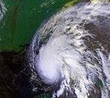
The 1995 Atlantic hurricane season was the third most active Atlantic hurricane season
on record. It officially began on June 1, 1995, and lasted until November 30, 1995. These dates conventionally delimit the period of each year when most tropical cyclone
s form in the north Atlantic ocean
. The 1995 season was extremely active, largely due to favorable conditions including a La Niña
and warm sea surface temperature
s. Nineteen named storms formed during the season, making it the third most active on record behind the 2005
and 1933
seasons and tied with 1887
, 2010
and the 2011 Atlantic hurricane season
. There were also eleven storms that reached hurricane strength, the fourth most hurricanes in one season after the 2010, 1969
, and the 2005 seasons. The most notable storms were Hurricane Luis
, Hurricane Marilyn
and Hurricane Opal
.
Totaling to $10.2 billion (1995 USD, $ USD) in damages and over 100 deaths, There were also a number of destructive hurricanes during the season such as Hurricane Erin
caused substantial damage in Florida
. Felix
caused heavy beach erosion in the northeast United States, and produced strong waves that drowned eight. Hurricane Iris
and especially Hurricanes Luis
and Marilyn
caused catastrophic damages in the Leeward Islands
and were the worst hurricanes to affect the islands since Hurricane Hugo
. Hurricane Opal
, the strongest storm of the season, caused very heavy damage along the U.S. Gulf Coast. Hurricane Roxanne
, a late-season major hurricane, caused heavy damage when it made landfall in Quintana Roo
. Another notable tropical cyclone was Allison
, which was the first Atlantic hurricane in the month of June since Alberto
in 1982.
 The Atlantic hurricane season officially began on June 1, and activity in 1995 began on the next day with the formation of Hurricane Allison
on June 2. It was a well-above average season in which 21 tropical depressions formed. 19 of the depressions attained tropical storm status, and 11 of these attained hurricane status. In addition, five tropical cyclones reached major hurricane status, which was well above the 1950-2005 average of two per season. Seven hurricane and five tropical storms made landfall, which caused a majority of the season's 158 deaths and $10.2 billion (1995 USD) in damage. Hurricane Felix
also caused damage and fatalities, but that storm never made landfall. The last storm of the season, Hurricane Tanya
, became extratropical on November 1, over four weeks before the official end of the season on November 30.
Tropical cyclogenesis
in the 1995 Atlantic hurricane season began with the development of Hurricane Allison on June 2. The month of July was very activity, with four tropical cyclones forming. A total of seven storms formed in August — Felix, Gabrielle
, Humberto
, Iris
, Jerry
, Karen, and Luis
— tying the 1933
record for most in the month; this record was broken in the 2004 Atlantic hurricane season
when eight named storms formed during August. Although September is the climatological peak of hurricane season, it was much less active with August, with four tropical cyclones developing in that month, and Marilyn
, Noel, and Opal
eventually strengthened into a hurricane. Four tropical cyclones also formed in October; notably, Hurricane Roxanne
developed in that month. The last storm of the season, Hurricane Tanya, developed later in October, and eventually became extratropical on November 1, which almost thirty days before the official end of the season on November 30.
The season's activity was reflected with a high accumulated cyclone energy
(ACE) rating of 228. ACE is, broadly speaking, a measure of the power of the hurricane multiplied by the length of time it existed, so storms that last a long time, as well as particularly strong hurricanes, have high ACEs. ACE is only calculated for full advisories on tropical systems at or exceeding 34 knots (39 mph, 63 km/h) or tropical storm strength.
on June 2, one of the earliest storm formations within a season on record. Continuing on its northwestern heading, Allison strengthened into a tropical storm on June 3, bringing steady rains and gusty winds to Cuba
. Despite upper-level winds, the storm continued to strengthen and Allison became a hurricane on June 4. Hurricane Allison then weakened to a tropical storm before landfall 23 miles (37 km) east of Carrabelle, Florida
on June 5; this made Allison the third-earliest storm to make U.S landfall. Allison moved inland and continued northeast, becoming an extratropical storm. The storm skirted the east coast, bringing gusty winds and heavy rains, before passing Nova Scotia
as it turned northwestward and dissipating west of Greenland
.
Although Allison had weakened to a tropical storm before making landfall in Florida, it brought a storm surge
of six to eight feet (1.8 to 2.4 m) and rainfall up to six inches (150 mm). At least 60 homes and businesses were damaged by the storm in Florida and several roadways were washed out. Four tornadoes touched down in the state, one of which was rated as an F1. Total damages in the state amounted to $860,000 (1995 USD, $ USD). In Georgia, several tornadoes touched down, and heavy rains triggered minor flooding. Damages in the state amounted to $800,000 (1995 USD, $ USD)).
and South Carolina
. The satellite imagery also revealed that a low-level cloud system center had become better defined just to the west of a small cluster of deep convection, and it is estimated that the frontal low transformed into Tropical Depression Two near 1800 UTC July 6. Tropical Depression Two became a named storm on July 7 off the coast of South Carolina
and was given the name Barry. The tropical storm then headed north, making landfall on the eastern tip of Nova Scotia
on July 9 and was declared extratropical the next day.
Barry brought heavy rainfall and moderate winds to Atlantic Canada
, especially in the provinces of Nova Scotia and Newfoundland. In Fourchu, Nova Scotia
winds reached 48 mph (77.2 km/h), which was the only reported of tropical storm force winds over land. A majority of precipitation produced by Barry occurred in Nova Scotia, which peaked at 4.3 inches (109.2 mm). Minor street flooding was reported following the heavy rainfall. After becoming extratropical, Barry dropped 2.5 inches (63.5 mm) of rain in Labrador
.
. However, Chantal re-curved to the north and did not directly affect the Bahamas. After the storm turned northward, it threatened Bermuda
, which prompted a tropical storm watch for the island on July 16; it was cancelled on July 18 as the storm passed well northwest of the island.
By early on July 17, Chantal nearly attained hurricane status, although it began to gradually weaken later that day. Chantal was declared extratropical on July 20 after it affected American shipping lines. Although Chantal remained well offshore, the storm managed to drop heavy rainfall in Nova Scotia
and Newfoundland
. Precipitation in Newfoundland was limited to the southern half of the island, and rainfall peaked at 3 inches (76.2 mm) on the Burin Peninsula
. Further west in Nova Scotia, heavier precipitation was reported, peaking at 4.84 inches (122.9 mm) near Barrington
.
in the Gulf of Mexico developed an upper-level circulation. By July 28, the system organized enough to be classified as Tropical Depression Four. Despite favorable conditions, the depression tracked westward without significantly intensifying. As the depression curved west-northwestward, it began to strengthen, and was upgraded to Tropical Storm Dean while located only 70 miles (110 km) from the Texas
coastline on July 30. Dean made landfall early on the July 31 near Freeport
with an intensity of 45 mph (75 km/h) and a central pressure of 999 mbar (hPa; 29.5 inHg). Only four hours after landfall, Dean weakened back to a tropical depression. The storm continued to slowly weaken as it moved northwestward, and dissipating on August 2 near the Texas/Oklahoma
border.
Dean dropped heavy rainfall amounting to nearly 17 inches (430 mm) in Monroe City
. The rainfall resulted in moderate localized damage and the evacuation of 20 families in Chambers County, but the storm caused no injuries or deaths. Despite the flooding, property damage estimates were only $500,000 (1995 USD, $ USD).
, where the system nearly developed into a tropical cyclone. By July 31, the system was classified as Tropical Storm Erin while just west of the Turks and Caicos Islands. Despite affects from wind shear, Erin continued to strengthen as it moved northwestward, and was upgraded to a hurricane later on July 31. Further intensification occurred, and Erin reached winds of 85 mi/h before making landfall near Vero Beach, Florida
on August 1. The storm emerged over the Gulf of Mexico after weakening back to a tropical storm, though it quickly re-strengthened into a hurricane. Shortly before making landfall near Pensacola Beach, Florida
on August 3, Erin managed to briefly intensify into a Category 2 hurricane. After moving inland, Erin slowly weakened as it tracked across the Southern United States
and Midwestern United States
. By August 6, Erin merged with a frontal system over West Virginia
.
Erin was the first hurricane to strike the United States since Hurricane Andrew
in 1992. In Jamaica
, the outerbands of Erin produced heavy rainfall on the island, which caused a plane crash, killing five people; two other fatalities occurred when two people were struck by lightning. Although many islands in the Bahamas experience high winds and heavy rainfall, damage associated with Erin was fairly minor. Offshore of Florida, nine people drowned, three of which occurred after a cruise ship sunk. Over land, high winds produced by Erin damaged over 2,000 houses, most of which were in the Florida Panhandle
. In addition, the storm left over 1 million people without electricity. Several tornadoes were spawned in the state, which also caused some damage. Over 100 houses were also damaged in Alabama. The pecan crop in Baldwin County
lost 50 to 75 percent of its total portion. Similar damage also occurred in Mississippi
, although to a lesser degree. Elsewhere, some areas affected by Erin experienced heavy rainfall. Overall, Erin caused 13 fatalities and $700 million (1995 USD) in damage.
, Veracruz
, Mexico, which prevented the depression from strengthening into a tropical storm. The depression slowly weakened inland and dissipated late on August 7.
The depression and the precursor tropical wave dropped heavy rainfall in some areas of Mexico. Precipitation from the system that eventually became Tropical Depression Six peaked at 14.45 inches (367 mm) in Escuintla, Chiapas
. However, rainfall from the depression itself peaked at 12 inches (304.8 mm) in Tlaxco
, Puebla
. Some localized flooding may have occurred near the path of the depression. However, no damage or fatalities were reported.
, and strengthened into Tropical Storm Felix later that day. Further intensification was slow, with Felix reaching hurricane status on August 11. Due to warm sea surface temperatures and light wind shear, Felix began to rapidly strengthen as it was curving northwestward. Late on August 12, Felix peaked with winds of 140 mph (220 km/h), making it the first Category 4 hurricane
since Hurricane Andrew in 1992. Felix quickly weakened back to a Category 1 hurricane after an eyewall replacement cycle
and an increase in wind shear.
The storm posed a significant threat to Bermuda, and warranted a hurricane warning between August 14 and August 15. During the latter date, Felix passed only 75 miles (121 km) to the southwest of the island. As it tracked west-northwestward, preparations were occurring as Felix also posed a threat to the United States. However, the storm curved northward and then east-northeastward while remaining offshore. Felix briefly threatened Bermuda again, but weakened to a tropical storm and turned back to the northeast on August 20. It accelerated east-northeastward, and passed a short distance offshore of Newfoundland, where it transitioned into an extratropical storm on August 22.
Large waves in Puerto Rico
caused minor coastal flooding in Cataño
. On Bermuda, the storm produced near-hurricane force winds, which downed trees and power lines, and left 20,000 people without power. Rough surf was also reported on Bermuda, which damaged a few boats and hotels. In addition, the passage of Felix postponed Bermuda's 1995 independence referendum. In the United States, Felix generated large waves from northeast Florida to Maine
. In New York
, two houses were washed away in The Hamptons, while 20 to 30 houses in North Carolina experience minor damage from rough seas. While passing southeast of Newfoundland, Felix produced moderate rainfall and large waves across the island, although damage was minimal. Overall, Felix caused eight deaths due to drowning along the coasts of North Carolina
and New Jersey
, and $132,000 (1995 USD) in damage.
, Mexico two hours later, which prevented further strengthening. Gabrielle rapidly weakened inland, and dissipated early on August 12.
Gabrielle dropped heavy rainfall in Mexico, especially around its landfall location, where some areas possibly experiencing more than 24 inches (609.6 mm) of precipitation. Though according to the Hydrometeorological Prediction Center
, rainfall peaked at 19.44 inches (493.8 mm). Further north, Gabrielle dropped light to moderate rainfall in Texas. Gabrielle caused six fatalities in Mexico, though the damage figure is unknown.
. Damage reports were sparse, but four deaths were reported on Martinique
due to mud slides.
On August 30, Iris began its second Fujiwhara interaction, this time with Tropical Storm Karen which it absorbed on September 3. The storm quickly became extratropical, and its motion accelerated. On September 7, Iris reached western Europe
as an extratropical storm with wind speeds still at 75 mi/h.
as a minimal tropical storm with winds of 40 mph (55 km/h). Jerry slowly weakened, and as downgraded to a tropical depression late on August 24. After drifting across the Florida, Jerry briefly emerged over the Gulf of Mexico
, but then headed northward and back inland. Jerry meandered over Georgia
, and eventually dissipated on August 28.
Jerry dropped heavy rainfall in Florida, especially in the southern portion of the state. Although the storm struck the east coast of the state, much of the damage in Florida occurred in Collier County
, which is in the southwestern part of that state. In that county, 340 houses were damaged and 12 others were destroyed due to flooding. Other nearby counties also reported flood damage, albeit less severe. Agricultural damage was also reported in southwest Florida. Heavy rainfall also occurred in Georgia, with some areas experiencing over 12 inches (300 mm) of rain. However, no significant flood damage occurred due to dry conditions preceding the rainfall. The remnants of Jerry produced heavy precipitation in North
and South Carolina
. In both states, many roads were flooded and numerous buildings and houses were damaged, especially in the Charlotte
and Raleigh
areas. Overall, there eight fatalities and $40 million (1995 USD) in damage associated with Jerry.
moved off of Africa
on August 23 and gradually developed a broad low pressure area
. It gradually organized, and developed into twelfth tropical depression of the season on August 26. Located in an environment of little wind shear
, the convection slowly organized, and on August 28 it intensified into Tropical Storm Karen.
After tracking steadily west-northwestward, the wake from nearby Hurricane Humberto turned Karen northward, and shortly thereafter began to encounter wind shear from the outflow of Hurricane Iris
. Despite this, the storm strengthened slightly to attain peak winds of 50 mph (80 km/h). Due to its Fujiwhara effect
with Iris, Karen steadily weakened while revolving around the larger circulation of Iris. On September 2, the storm degenerated into a tropical depression, and the next day Karen was absorbed by Iris a short distance to the east of Bermuda
. Karen never affected land; the highest strike probability for the storm was for Bermuda and Halifax, Nova Scotia
, both of which were assessed to have a 2% chance of being passed by Karen within 65 miles.
since Hurricane Hugo
, Luis formed on August 29, becoming the fourth concurrent named storm in the north Atlantic ocean
. Luis would intensify as it traveled across the Atlantic, and satellite estimates placed it at Category 5 intensity on September 3. By late September 4 and 5, Luis had reached the Leeward Islands
, the center passed 20 miles north of Sint Maarten/Saint Martin as it caused very extensive damage totaling $1.8 billion USD on the small island. It would eventually head north and become a strong extratropical storm over Newfoundland.
Luis is officially reported to have killed 16 with numerous missing in the Leeward Islands and 1 in Newfoundland. Damage was substantial, with upwards of half the structures reported damaged on the northern Lesser Antilles
. Estimated total damage was $2.5 billion (1995 USD). RMS Queen Elizabeth 2
, en route to New York early in the morning of September 11, encountered an 87 foot (29 m) rogue wave generated by Hurricane Luis. Damage to the ship was somewhat minor, and no passengers or crew were injured. Luis affected the Leeward Islands only a week after Hurricane Iris and only ten days before Hurricane Marilyn
.
, Marilyn weakened and became extratropical on September 22.
Marilyn is directly responsible for eight deaths, most due to drowning on boats or offshore. Ten thousand people were left homeless on the island of St. Thomas, and estimated damages were set at $1.5 billion (1995 USD), making it the most destructive hurricane to hit the Virgin Islands since Hurricane Hugo
in 1989.
on September 22, and within three days began to develop organized convection. After a low-level circulation formed, the system developed into Tropical Depression Sixteen late on September 26. Despite the presence of wind shear, the depression strengthened into Tropical Storm Noel on September 27. Moving northwestward, it gradually intensified to hurricane status by September 28, with peak winds of 75 mph (120 km/h). After remaining a hurricane for 42 hours, during which it turned to the northeast, Noel weakened to tropical storm strength due to increased wind shear.
Although forecast to weaken to a tropical depression, Noel maintained minimal tropical storm force as it curved to the northwest. Following a decrease in shear, Noel regained hurricane status on October 5 about 950 miles (1,528.9 km) west-southwest of the Azores
. It turned to the east, and the return of unfavorable conditions caused weakening back to tropical storm status by October 6. A day later, Noel weakened below tropical storm force as it transitioned to an extratropical cyclone. The remnants lasted until late on October 7 until they were absorbed by a cold front. The hurricane never affected land.
, becoming a tropical depression on September 27 while 80 miles (128.7 km) south-southeast of Cozumel
. The depression slowly moved over the Yucatan for the next several days, eventually emerging over the Bay of Campeche
where it was officially upgraded to tropical storm strength. It rapidly intensified and began moving north across the Gulf of Mexico. Opal reached Category 4 hurricane
status, with sustained winds of 152 mi/h, but weakened to a minimal Category 3 hurricane by the time of landfall at Pensacola Beach, Florida
on October 4.
Opal killed 59 people: 31 from flooding in Guatemala, 19 in Mexico from flooding, and 9 in the United States. The United States deaths include one in Florida by a tornado
, and the other eight from falling trees in Alabama
, Georgia
, and North Carolina
. No deaths were reported from storm surge
, which is unusual due to the storm's strength and the location of landfall. Opal caused $3 billion ($6 billion in 2008 USD) in damage, making it the eighteenth costliest U.S. hurricane when adjusted for inflation, as of the completion of the 2004 hurricane season. It was not until Hurricane Olga
in 2001
that a storm received another 'O' name; it would be repeated for the 2003
, 2004
, 2005
, 2007
, 2008
, 2010
and 2011
seasons.
The storm prompted a tropical storm watch for several islands, but it dissipated without causing any impact. Pablo was the first storm to be assigned a name beginning with 'P' since storm naming began in the Atlantic
in 1950.
. The system quickly organized into Tropical Depression Nineteen on October 7. The depression brushed Central America before curving northward, where it strengthened into Tropical Storm Roxanne on October 9. Roxanne posed a threat to Cuba and the Cayman Islands
, which briefly prompted the issuance of a tropical storm warning and a hurricane watch. However, a high pressure system forced Roxanne to tracked generally westward, which prevented it from significantly affecting the aforementioned islands. After becoming a hurricane on October 10, Roxanne began to rapidly strengthen. Later that day, the storm peaked as a minimal Category 3 hurricane, with winds of 115 mph (185 km/h).
By 0200 UTC on October 11, Roxanne made landfall just north of Tulum, Quintana Roo
on the Yucatan Peninsula with winds of 115 mph (185 km/h). The storm significantly weakened inland, and emerged into the Bay of Campeche
as a tropical storm. Several short wave troughs and ridges caused Roxanne to track aimlessly through the southern Gulf of Mexico. By October 14, it re-strengthened into a hurricane. After nearing making another landfall in the Yucatan Peninsula while heading southeastward, Roxanne weakened to a tropical storm on October 17 as it doubled back to the northwest. A cold front forced Roxanne westward on October 19, while it had weakened to a tropical depression. It curved abruptly southward, and dissipated just offshore of Veracruz on October 21.
Due to its erratic movement, Roxanne dropped heavy rainfall in many areas of southern Mexico, and some areas reported over 25 inches (640 mm) of precipitation. Extensive flooding occurred as a result, which destroyed crops, washed out roads, and damaged at least 40,000 homes. In addition, significant coastal flooding also occurred, as storm surge for nearly a week caused water to travel inland for hundreds of yards. High winds also occurred over the Yucatan Peninsula, with one station reporting hurricane force winds on October 11. Overall, Roxanne caused $1.5 billion (1995 USD) in damage and 29 fatalities. However, not all damage could be distinguished from Hurricane Opal. Roxanne was the first named storm in the Atlantic to begin with the letter "R". It wouldn't be until Hurricane Rita
in 2005
, Hurricane Richard in 2010
, and Hurricane Rina in 2011
that a storm received an 'R' name again.
Sebastien began weakening as it tracked southwestward and was downgraded to a tropical depression on October 24. As it tracked through the Lesser Antilles, Sebastien made landfall on Anguilla
. Minor damage was reported, and the remnants of Sebastien dropped light rainfall in Puerto Rico. Sebastien was the first of four storms to be assigned a name beginning with 'S' Atlantic basin since 1950; the other three were Hurricane Stan
in 2005, Hurricane Shary in 2010 and Tropical Storm Sean
in 2011.
in 1950. Tanya formed on October 27 in the Central Atlantic. The cyclone initially displayed subtropical characteristics, including comma-shaped convection and winds extending well out from the center. It became more tropical on the 29th as it formed a small eye near the center, indicating it had become a hurricane. A cold front pushed the storm northward, then northeastward. Tanya became extratropical as it neared the Azores
on November 2, and quickly crossed through the islands. The extratropical storm continued northeastward, eventually being absorbed by a non-tropical low pressure system on November 3.
Tanya was the first tropical cyclone to affect the Azores since Hurricane Charley
in 1992. In the Azores, Tanya tore roofs off houses and downed trees, and light posts flew through houses and buildings. Only one death (by drowning) was reported, as well as several injuries. The Red Cross and the Portuguese government spent over $6 million (1995 USD) in repairs. The islands of Faial
, Pico, Terceira and São Jorge were hardest hit, where the storm sank or damaged numerous boats. The storm also severely disrupted electricity and telecommunications, damaged several houses and caused moderate crop damage.
Tanya was the only Atlantic tropical cyclone name that began with "T" until Tropical Storm Tammy
in 2005
and Hurricane Tomas
in 2010
.
. This is the same list used for the 1989 season
except Humberto, which replaced Hugo
. Storms were named Humberto, Luis, Marilyn, Noel, Opal, Pablo, Roxanne, Sebastien, and Tanya for the first time in 1995. Names that were not assigned are marked in (Van and Wendy were the only two in the season).
retired four names in the spring of 1996: Luis, Marilyn, Opal, and Roxanne. They were replaced in the 2001 season
by Lorenzo, Michelle
, Olga, and Rebekah. The name Michelle
, however, was retired after 2001 and replaced with Melissa for the 2007 season
. The 1995 season was tied with the 1955 season
and 2004 season
for the most storm names retired after a single season until the 2005 season
, when five names were retired.
Atlantic hurricane season
The Atlantic hurricane season is the period in a year when hurricanes usually form in the Atlantic Ocean. Tropical cyclones in the North Atlantic are called hurricanes, tropical storms, or tropical depressions. In addition, there have been several storms over the years that have not been fully...
on record. It officially began on June 1, 1995, and lasted until November 30, 1995. These dates conventionally delimit the period of each year when most tropical cyclone
Tropical cyclone
A tropical cyclone is a storm system characterized by a large low-pressure center and numerous thunderstorms that produce strong winds and heavy rain. Tropical cyclones strengthen when water evaporated from the ocean is released as the saturated air rises, resulting in condensation of water vapor...
s form in the north Atlantic ocean
Atlantic Ocean
The Atlantic Ocean is the second-largest of the world's oceanic divisions. With a total area of about , it covers approximately 20% of the Earth's surface and about 26% of its water surface area...
. The 1995 season was extremely active, largely due to favorable conditions including a La Niña
La Niña
La Niña is a coupled ocean-atmosphere phenomenon that is the counterpart of El Niño as part of the broader El Niño-Southern Oscillation climate pattern. During a period of La Niña, the sea surface temperature across the equatorial Eastern Central Pacific Ocean will be lower than normal by 3–5 °C...
and warm sea surface temperature
Sea surface temperature
Sea surface temperature is the water temperature close to the oceans surface. The exact meaning of surface varies according to the measurement method used, but it is between and below the sea surface. Air masses in the Earth's atmosphere are highly modified by sea surface temperatures within a...
s. Nineteen named storms formed during the season, making it the third most active on record behind the 2005
2005 Atlantic hurricane season
The 2005 Atlantic hurricane season was the most active Atlantic hurricane season in recorded history, repeatedly shattering numerous records. The impact of the season was widespread and ruinous with an estimated 3,913 deaths and record damage of about $159.2 billion...
and 1933
1933 Atlantic hurricane season
The 1933 Atlantic hurricane season was the second most active Atlantic hurricane season on record, with 21 storms forming during that year in the northwest Atlantic Ocean. The season ran through the summer and the first half of fall in 1933, and was surpassed in total number of tropical cyclones by...
seasons and tied with 1887
1887 Atlantic hurricane season
Another May storm formed south of Jamaica on May 17, way outside of the season and moved generally northward. It crossed Cuba on the 19th as a tropical storm, and moved out to sea. Two peaked at twice, once on May 18 and May 20. Two dissipated on the 21st in the Atlantic Ocean...
, 2010
2010 Atlantic hurricane season
The 2010 Atlantic hurricane season was the third most active Atlantic hurricane season on record, tying with the 1887 Atlantic hurricane season, 1995 Atlantic hurricane season and the 2011 Atlantic hurricane season. It had the most number of named storms since the 2005 season and also ties with the...
and the 2011 Atlantic hurricane season
2011 Atlantic hurricane season
The 2011 Atlantic hurricane season is tied for the third most active season on record with 1887, 1995 and 2010. It began on June 1, 2011, and ended on November 30, 2011, however these dates conventionally delimit the period of each year when most tropical cyclones develop in the Atlantic basin...
. There were also eleven storms that reached hurricane strength, the fourth most hurricanes in one season after the 2010, 1969
1969 Atlantic hurricane season
The 1969 Atlantic hurricane season officially began on June 1, 1969, and lasted until November 30, 1969. These dates conventionally delimit the period of each year when most tropical cyclones form in the Atlantic basin. The season was among the most active on record, with 18 tropical cyclones, 12...
, and the 2005 seasons. The most notable storms were Hurricane Luis
Hurricane Luis
Hurricane Luis was one of the deadliest and most destructive hurricanes of the 1995 Atlantic hurricane season, with maximum sustained winds of 140 mph . The storm was the twelfth tropical storm, sixth hurricane, and second major hurricane of the season...
, Hurricane Marilyn
Hurricane Marilyn
Hurricane Marilyn was the fifteenth tropical depression and thirteenth named storm of the unusually busy 1995 Atlantic hurricane season, following closely on the heels of Hurricane Luis. Hurricane Marilyn was the most powerful storm to hit the Virgin Islands since Hurricane Hugo of 1989.Marilyn...
and Hurricane Opal
Hurricane Opal
Hurricane Opal was a Category 4 hurricane that formed in the Gulf of Mexico in September 1995.Opal was the ninth hurricane and the strongest of the abnormally active 1995 Atlantic hurricane season...
.
Totaling to $10.2 billion (1995 USD, $ USD) in damages and over 100 deaths, There were also a number of destructive hurricanes during the season such as Hurricane Erin
Hurricane Erin (1995)
Hurricane Erin was the fifth named tropical cyclone and the second hurricane of the unusually active 1995 Atlantic hurricane season. Erin began as a tropical wave off the west coast of Africa on July 22, and crossed the Atlantic ocean without ever developing. On July 31, the last day of the month,...
caused substantial damage in Florida
Florida
Florida is a state in the southeastern United States, located on the nation's Atlantic and Gulf coasts. It is bordered to the west by the Gulf of Mexico, to the north by Alabama and Georgia and to the east by the Atlantic Ocean. With a population of 18,801,310 as measured by the 2010 census, it...
. Felix
Hurricane Felix (1995)
Hurricane Felix was the sixth named tropical cyclone and the third hurricane of the unusually active 1995 Atlantic hurricane season. Though the Cape Verde-type hurricane never made landfall, Felix stalled off the coast of North Carolina, resulting in great uncertainty over its track...
caused heavy beach erosion in the northeast United States, and produced strong waves that drowned eight. Hurricane Iris
Hurricane Iris (1995)
Hurricane Iris was the ninth named tropical cyclone and fifth hurricane of an active 1995 Atlantic hurricane season. Iris was one of four storms to form nearly simultaneously in the Atlantic during the 1995 season. Forming on August 22, Iris slowly drifted across the Leeward Islands as a tropical...
and especially Hurricanes Luis
Hurricane Luis
Hurricane Luis was one of the deadliest and most destructive hurricanes of the 1995 Atlantic hurricane season, with maximum sustained winds of 140 mph . The storm was the twelfth tropical storm, sixth hurricane, and second major hurricane of the season...
and Marilyn
Hurricane Marilyn
Hurricane Marilyn was the fifteenth tropical depression and thirteenth named storm of the unusually busy 1995 Atlantic hurricane season, following closely on the heels of Hurricane Luis. Hurricane Marilyn was the most powerful storm to hit the Virgin Islands since Hurricane Hugo of 1989.Marilyn...
caused catastrophic damages in the Leeward Islands
Leeward Islands
The Leeward Islands are a group of islands in the West Indies. They are the northern islands of the Lesser Antilles chain. As a group they start east of Puerto Rico and reach southward to Dominica. They are situated where the northeastern Caribbean Sea meets the western Atlantic Ocean...
and were the worst hurricanes to affect the islands since Hurricane Hugo
Hurricane Hugo
Hurricane Hugo was a classical, destructive and rare Cape Verde-type hurricane which struck the Caribbean islands of Guadeloupe, Montserrat, St. Croix, Puerto Rico and the USA mainland in South Carolina as a Category 4 hurricane during September of the 1989 Atlantic hurricane season...
. Hurricane Opal
Hurricane Opal
Hurricane Opal was a Category 4 hurricane that formed in the Gulf of Mexico in September 1995.Opal was the ninth hurricane and the strongest of the abnormally active 1995 Atlantic hurricane season...
, the strongest storm of the season, caused very heavy damage along the U.S. Gulf Coast. Hurricane Roxanne
Hurricane Roxanne
Hurricane Roxanne caused extensive flooding in Mexico due to its erratic movement. The seventeenth storm, tenth hurricane, and the fifth and final major hurricane of the very active 1995 Atlantic hurricane season, Roxanne developed in the southwestern Caribbean Sea from an area of low pressure on...
, a late-season major hurricane, caused heavy damage when it made landfall in Quintana Roo
Quintana Roo
Quintana Roo officially Estado Libre y Soberano de Quintana Roo is one of the 31 states which, with the Federal District, comprise the 32 Federal Entities of Mexico. It is divided in 10 municipalities and its capital city is Chetumal....
. Another notable tropical cyclone was Allison
Hurricane Allison (1995)
Hurricane Allison was the first named storm and first hurricane of the 1995 Atlantic hurricane season. It was an early season hurricane that delivered heavy rains and caused minor damage, primarily across Cuba, Florida and Georgia....
, which was the first Atlantic hurricane in the month of June since Alberto
Hurricane Alberto (1982)
Hurricane Alberto caused the worst flooding in western Cuba in 32 years. The first tropical storm and hurricane of the 1982 Atlantic hurricane season, Alberto developed from a tropical disturbance on June 2 in the southern Gulf of Mexico...
in 1982.
Seasonal activity
Hurricane Allison (1995)
Hurricane Allison was the first named storm and first hurricane of the 1995 Atlantic hurricane season. It was an early season hurricane that delivered heavy rains and caused minor damage, primarily across Cuba, Florida and Georgia....
on June 2. It was a well-above average season in which 21 tropical depressions formed. 19 of the depressions attained tropical storm status, and 11 of these attained hurricane status. In addition, five tropical cyclones reached major hurricane status, which was well above the 1950-2005 average of two per season. Seven hurricane and five tropical storms made landfall, which caused a majority of the season's 158 deaths and $10.2 billion (1995 USD) in damage. Hurricane Felix
Hurricane Felix (1995)
Hurricane Felix was the sixth named tropical cyclone and the third hurricane of the unusually active 1995 Atlantic hurricane season. Though the Cape Verde-type hurricane never made landfall, Felix stalled off the coast of North Carolina, resulting in great uncertainty over its track...
also caused damage and fatalities, but that storm never made landfall. The last storm of the season, Hurricane Tanya
Hurricane Tanya (1995)
Hurricane Tanya was the final storm of the very active 1995 Atlantic hurricane season. The twenty-first tropical cyclone, nineteenth named storm, and eleventh hurricane of the season, Tanya developed from a tropical wave while well north of the Lesser Antilles on October 26. The system headed...
, became extratropical on November 1, over four weeks before the official end of the season on November 30.
Tropical cyclogenesis
Tropical cyclogenesis
Tropical cyclogenesis is the term that describes the development and strengthening of a tropical cyclone in the atmosphere. The mechanisms through which tropical cyclogenesis occurs are distinctly different from those through which mid-latitude cyclogenesis occurs...
in the 1995 Atlantic hurricane season began with the development of Hurricane Allison on June 2. The month of July was very activity, with four tropical cyclones forming. A total of seven storms formed in August — Felix, Gabrielle
Tropical Storm Gabrielle (1995)
Tropical Storm Gabrielle was a short-lived storm in the Gulf of Mexico in the 1995 Atlantic hurricane season that had an erratic path across the western Gulf. It was the seventh named storm of the season. Gabrielle formed on August 9, 1995 east of the Mexican state of Tamaulipas. It slowly...
, Humberto
Hurricane Humberto (1995)
Hurricane Humberto was the eighth named storm and fourth hurricane of the busy 1995 Atlantic hurricane season. This was the first time that the name "Humberto" was used as it replaced Hugo...
, Iris
Hurricane Iris (1995)
Hurricane Iris was the ninth named tropical cyclone and fifth hurricane of an active 1995 Atlantic hurricane season. Iris was one of four storms to form nearly simultaneously in the Atlantic during the 1995 season. Forming on August 22, Iris slowly drifted across the Leeward Islands as a tropical...
, Jerry
Tropical Storm Jerry (1995)
Tropical Storm Jerry was a tropical storm that caused severe flooding throughout the southeast United States in August of the 1995 Atlantic hurricane season...
, Karen, and Luis
Hurricane Luis
Hurricane Luis was one of the deadliest and most destructive hurricanes of the 1995 Atlantic hurricane season, with maximum sustained winds of 140 mph . The storm was the twelfth tropical storm, sixth hurricane, and second major hurricane of the season...
— tying the 1933
1933 Atlantic hurricane season
The 1933 Atlantic hurricane season was the second most active Atlantic hurricane season on record, with 21 storms forming during that year in the northwest Atlantic Ocean. The season ran through the summer and the first half of fall in 1933, and was surpassed in total number of tropical cyclones by...
record for most in the month; this record was broken in the 2004 Atlantic hurricane season
2004 Atlantic hurricane season
The 2004 Atlantic hurricane season officially began on June 1, 2004, and lasted until November 30, 2004. These dates conventionally delimit the period of each year when most tropical cyclones form in the Atlantic basin...
when eight named storms formed during August. Although September is the climatological peak of hurricane season, it was much less active with August, with four tropical cyclones developing in that month, and Marilyn
Hurricane Marilyn
Hurricane Marilyn was the fifteenth tropical depression and thirteenth named storm of the unusually busy 1995 Atlantic hurricane season, following closely on the heels of Hurricane Luis. Hurricane Marilyn was the most powerful storm to hit the Virgin Islands since Hurricane Hugo of 1989.Marilyn...
, Noel, and Opal
Hurricane Opal
Hurricane Opal was a Category 4 hurricane that formed in the Gulf of Mexico in September 1995.Opal was the ninth hurricane and the strongest of the abnormally active 1995 Atlantic hurricane season...
eventually strengthened into a hurricane. Four tropical cyclones also formed in October; notably, Hurricane Roxanne
Hurricane Roxanne
Hurricane Roxanne caused extensive flooding in Mexico due to its erratic movement. The seventeenth storm, tenth hurricane, and the fifth and final major hurricane of the very active 1995 Atlantic hurricane season, Roxanne developed in the southwestern Caribbean Sea from an area of low pressure on...
developed in that month. The last storm of the season, Hurricane Tanya, developed later in October, and eventually became extratropical on November 1, which almost thirty days before the official end of the season on November 30.
The season's activity was reflected with a high accumulated cyclone energy
Accumulated cyclone energy
Accumulated cyclone energy is a measure used by the National Oceanic and Atmospheric Administration to express the activity of individual tropical cyclones and entire tropical cyclone seasons, particularly the North Atlantic hurricane season. It uses an approximation of the energy used by a...
(ACE) rating of 228. ACE is, broadly speaking, a measure of the power of the hurricane multiplied by the length of time it existed, so storms that last a long time, as well as particularly strong hurricanes, have high ACEs. ACE is only calculated for full advisories on tropical systems at or exceeding 34 knots (39 mph, 63 km/h) or tropical storm strength.
Hurricane Allison
Allison formed from a tropical depression that was detected southeast of CubaCuba
The Republic of Cuba is an island nation in the Caribbean. The nation of Cuba consists of the main island of Cuba, the Isla de la Juventud, and several archipelagos. Havana is the largest city in Cuba and the country's capital. Santiago de Cuba is the second largest city...
on June 2, one of the earliest storm formations within a season on record. Continuing on its northwestern heading, Allison strengthened into a tropical storm on June 3, bringing steady rains and gusty winds to Cuba
Cuba
The Republic of Cuba is an island nation in the Caribbean. The nation of Cuba consists of the main island of Cuba, the Isla de la Juventud, and several archipelagos. Havana is the largest city in Cuba and the country's capital. Santiago de Cuba is the second largest city...
. Despite upper-level winds, the storm continued to strengthen and Allison became a hurricane on June 4. Hurricane Allison then weakened to a tropical storm before landfall 23 miles (37 km) east of Carrabelle, Florida
Carrabelle, Florida
Carrabelle is a city in Franklin County, Florida, United States. The population was 1,303 at the 2000 census. According to the U.S Census estimates of 2009, the city had a population of 1,231.-Location:...
on June 5; this made Allison the third-earliest storm to make U.S landfall. Allison moved inland and continued northeast, becoming an extratropical storm. The storm skirted the east coast, bringing gusty winds and heavy rains, before passing Nova Scotia
Nova Scotia
Nova Scotia is one of Canada's three Maritime provinces and is the most populous province in Atlantic Canada. The name of the province is Latin for "New Scotland," but "Nova Scotia" is the recognized, English-language name of the province. The provincial capital is Halifax. Nova Scotia is the...
as it turned northwestward and dissipating west of Greenland
Greenland
Greenland is an autonomous country within the Kingdom of Denmark, located between the Arctic and Atlantic Oceans, east of the Canadian Arctic Archipelago. Though physiographically a part of the continent of North America, Greenland has been politically and culturally associated with Europe for...
.
Although Allison had weakened to a tropical storm before making landfall in Florida, it brought a storm surge
Storm surge
A storm surge is an offshore rise of water associated with a low pressure weather system, typically tropical cyclones and strong extratropical cyclones. Storm surges are caused primarily by high winds pushing on the ocean's surface. The wind causes the water to pile up higher than the ordinary sea...
of six to eight feet (1.8 to 2.4 m) and rainfall up to six inches (150 mm). At least 60 homes and businesses were damaged by the storm in Florida and several roadways were washed out. Four tornadoes touched down in the state, one of which was rated as an F1. Total damages in the state amounted to $860,000 (1995 USD, $ USD). In Georgia, several tornadoes touched down, and heavy rains triggered minor flooding. Damages in the state amounted to $800,000 (1995 USD, $ USD)).
Tropical Storm Barry
The National Hurricane Center surface analysis found a weak 1019 mbar (hPa; 30.09 inHg) frontal low between BermudaBermuda
Bermuda is a British overseas territory in the North Atlantic Ocean. Located off the east coast of the United States, its nearest landmass is Cape Hatteras, North Carolina, about to the west-northwest. It is about south of Halifax, Nova Scotia, Canada, and northeast of Miami, Florida...
and South Carolina
South Carolina
South Carolina is a state in the Deep South of the United States that borders Georgia to the south, North Carolina to the north, and the Atlantic Ocean to the east. Originally part of the Province of Carolina, the Province of South Carolina was one of the 13 colonies that declared independence...
. The satellite imagery also revealed that a low-level cloud system center had become better defined just to the west of a small cluster of deep convection, and it is estimated that the frontal low transformed into Tropical Depression Two near 1800 UTC July 6. Tropical Depression Two became a named storm on July 7 off the coast of South Carolina
South Carolina
South Carolina is a state in the Deep South of the United States that borders Georgia to the south, North Carolina to the north, and the Atlantic Ocean to the east. Originally part of the Province of Carolina, the Province of South Carolina was one of the 13 colonies that declared independence...
and was given the name Barry. The tropical storm then headed north, making landfall on the eastern tip of Nova Scotia
Nova Scotia
Nova Scotia is one of Canada's three Maritime provinces and is the most populous province in Atlantic Canada. The name of the province is Latin for "New Scotland," but "Nova Scotia" is the recognized, English-language name of the province. The provincial capital is Halifax. Nova Scotia is the...
on July 9 and was declared extratropical the next day.
Barry brought heavy rainfall and moderate winds to Atlantic Canada
Atlantic Canada
Atlantic Canada is the region of Canada comprising the four provinces located on the Atlantic coast, excluding Quebec: the three Maritime provinces – New Brunswick, Prince Edward Island, and Nova Scotia – and Newfoundland and Labrador...
, especially in the provinces of Nova Scotia and Newfoundland. In Fourchu, Nova Scotia
Fourchu, Nova Scotia
Fourchu is a small community located on Nova Scotia Route 247 in Richmond County on Cape Breton Island.-References:*...
winds reached 48 mph (77.2 km/h), which was the only reported of tropical storm force winds over land. A majority of precipitation produced by Barry occurred in Nova Scotia, which peaked at 4.3 inches (109.2 mm). Minor street flooding was reported following the heavy rainfall. After becoming extratropical, Barry dropped 2.5 inches (63.5 mm) of rain in Labrador
Labrador
Labrador is the distinct, northerly region of the Canadian province of Newfoundland and Labrador. It comprises the mainland portion of the province, separated from the island of Newfoundland by the Strait of Belle Isle...
.
Tropical Storm Chantal
Chantal originated from a tropical wave that moved off the coast of Africa on July 5. The wave developed a circulation and was declared a tropical depression on July 12. The depression quickly strengthened into Tropical Storm Chantal. Initially, Chantal threatened the Bahamas, and the Government of the Bahamas issued a tropical storm watches and warnings, which were in effect for southeast and central islands as well as the Turks and Caicos IslandsTurks and Caicos Islands
The Turks and Caicos Islands are a British Overseas Territory and overseas territory of the European Union consisting of two groups of tropical islands in the Caribbean, the larger Caicos Islands and the smaller Turks Islands, known for tourism and as an offshore financial centre.The Turks and...
. However, Chantal re-curved to the north and did not directly affect the Bahamas. After the storm turned northward, it threatened Bermuda
Bermuda
Bermuda is a British overseas territory in the North Atlantic Ocean. Located off the east coast of the United States, its nearest landmass is Cape Hatteras, North Carolina, about to the west-northwest. It is about south of Halifax, Nova Scotia, Canada, and northeast of Miami, Florida...
, which prompted a tropical storm watch for the island on July 16; it was cancelled on July 18 as the storm passed well northwest of the island.
By early on July 17, Chantal nearly attained hurricane status, although it began to gradually weaken later that day. Chantal was declared extratropical on July 20 after it affected American shipping lines. Although Chantal remained well offshore, the storm managed to drop heavy rainfall in Nova Scotia
Nova Scotia
Nova Scotia is one of Canada's three Maritime provinces and is the most populous province in Atlantic Canada. The name of the province is Latin for "New Scotland," but "Nova Scotia" is the recognized, English-language name of the province. The provincial capital is Halifax. Nova Scotia is the...
and Newfoundland
Newfoundland and Labrador
Newfoundland and Labrador is the easternmost province of Canada. Situated in the country's Atlantic region, it incorporates the island of Newfoundland and mainland Labrador with a combined area of . As of April 2011, the province's estimated population is 508,400...
. Precipitation in Newfoundland was limited to the southern half of the island, and rainfall peaked at 3 inches (76.2 mm) on the Burin Peninsula
Burin Peninsula
The Burin Peninsula is a Canadian peninsula located on the south coast of the island of Newfoundland in the province of Newfoundland and Labrador....
. Further west in Nova Scotia, heavier precipitation was reported, peaking at 4.84 inches (122.9 mm) near Barrington
Barrington, Nova Scotia
Barrington is a municipal district in western Shelburne County, Nova Scotia.Barrington forms the southernmost part of the province and contains Cape Sable, the eastern boundary between the North Atlantic Ocean and the Gulf of Maine.- Demographics :...
.
Tropical Storm Dean
A stationary frontStationary front
A stationary front is a boundary between two different air masses, neither of which is strong enough to replace the other. On a weather map, this is shown by an inter-playing series of blue spikes pointing one direction and red domes pointing the other. They tend to remain essentially in the same...
in the Gulf of Mexico developed an upper-level circulation. By July 28, the system organized enough to be classified as Tropical Depression Four. Despite favorable conditions, the depression tracked westward without significantly intensifying. As the depression curved west-northwestward, it began to strengthen, and was upgraded to Tropical Storm Dean while located only 70 miles (110 km) from the Texas
Texas
Texas is the second largest U.S. state by both area and population, and the largest state by area in the contiguous United States.The name, based on the Caddo word "Tejas" meaning "friends" or "allies", was applied by the Spanish to the Caddo themselves and to the region of their settlement in...
coastline on July 30. Dean made landfall early on the July 31 near Freeport
Freeport, Texas
Freeport is a city in Brazoria County, Texas within the Houston–Sugar Land–Baytown metropolitan area and is situated in Southeast Texas. As of the 2000 U.S...
with an intensity of 45 mph (75 km/h) and a central pressure of 999 mbar (hPa; 29.5 inHg). Only four hours after landfall, Dean weakened back to a tropical depression. The storm continued to slowly weaken as it moved northwestward, and dissipating on August 2 near the Texas/Oklahoma
Oklahoma
Oklahoma is a state located in the South Central region of the United States of America. With an estimated 3,751,351 residents as of the 2010 census and a land area of 68,667 square miles , Oklahoma is the 28th most populous and 20th-largest state...
border.
Dean dropped heavy rainfall amounting to nearly 17 inches (430 mm) in Monroe City
Monroe City, Texas
Monroe City is an unincorporated area in Chambers County, Texas, United States.-External links:...
. The rainfall resulted in moderate localized damage and the evacuation of 20 families in Chambers County, but the storm caused no injuries or deaths. Despite the flooding, property damage estimates were only $500,000 (1995 USD, $ USD).
Hurricane Erin
A tropical wave exited the west coast of Africa on July 22 and headed toward the Leeward IslandsLeeward Islands
The Leeward Islands are a group of islands in the West Indies. They are the northern islands of the Lesser Antilles chain. As a group they start east of Puerto Rico and reach southward to Dominica. They are situated where the northeastern Caribbean Sea meets the western Atlantic Ocean...
, where the system nearly developed into a tropical cyclone. By July 31, the system was classified as Tropical Storm Erin while just west of the Turks and Caicos Islands. Despite affects from wind shear, Erin continued to strengthen as it moved northwestward, and was upgraded to a hurricane later on July 31. Further intensification occurred, and Erin reached winds of 85 mi/h before making landfall near Vero Beach, Florida
Vero Beach, Florida
Vero Beach is a city in Indian River County, Florida, USA. According to the U.S. Census Bureau's 2006 estimates, the city had a population of 16,939. It is the county seat of Indian River County...
on August 1. The storm emerged over the Gulf of Mexico after weakening back to a tropical storm, though it quickly re-strengthened into a hurricane. Shortly before making landfall near Pensacola Beach, Florida
Pensacola Beach, Florida
Pensacola Beach is an unincorporated community located on Santa Rosa Island, a barrier island, in Escambia County, Florida, United States. It is situated south of Pensacola, and Gulf Breeze connected via bridges spanning to the Fairpoint Peninsula and then to the island, on the Gulf of Mexico...
on August 3, Erin managed to briefly intensify into a Category 2 hurricane. After moving inland, Erin slowly weakened as it tracked across the Southern United States
Southern United States
The Southern United States—commonly referred to as the American South, Dixie, or simply the South—constitutes a large distinctive area in the southeastern and south-central United States...
and Midwestern United States
Midwestern United States
The Midwestern United States is one of the four U.S. geographic regions defined by the United States Census Bureau, providing an official definition of the American Midwest....
. By August 6, Erin merged with a frontal system over West Virginia
West Virginia
West Virginia is a state in the Appalachian and Southeastern regions of the United States, bordered by Virginia to the southeast, Kentucky to the southwest, Ohio to the northwest, Pennsylvania to the northeast and Maryland to the east...
.
Erin was the first hurricane to strike the United States since Hurricane Andrew
Hurricane Andrew
Hurricane Andrew was the third Category 5 hurricane to make landfall in the United States, after the Labor Day Hurricane of 1935 and Hurricane Camille in 1969. Andrew was the first named storm and only major hurricane of the otherwise inactive 1992 Atlantic hurricane season...
in 1992. In Jamaica
Jamaica
Jamaica is an island nation of the Greater Antilles, in length, up to in width and 10,990 square kilometres in area. It is situated in the Caribbean Sea, about south of Cuba, and west of Hispaniola, the island harbouring the nation-states Haiti and the Dominican Republic...
, the outerbands of Erin produced heavy rainfall on the island, which caused a plane crash, killing five people; two other fatalities occurred when two people were struck by lightning. Although many islands in the Bahamas experience high winds and heavy rainfall, damage associated with Erin was fairly minor. Offshore of Florida, nine people drowned, three of which occurred after a cruise ship sunk. Over land, high winds produced by Erin damaged over 2,000 houses, most of which were in the Florida Panhandle
Florida Panhandle
The Florida Panhandle, an informal, unofficial term for the northwestern part of Florida, is a strip of land roughly 200 miles long and 50 to 100 miles wide , lying between Alabama on the north and the west, Georgia also on the north, and the Gulf of Mexico to the south. Its eastern boundary is...
. In addition, the storm left over 1 million people without electricity. Several tornadoes were spawned in the state, which also caused some damage. Over 100 houses were also damaged in Alabama. The pecan crop in Baldwin County
Baldwin County, Alabama
-2010:Whereas according to the 2010 U.S. Census Bureau:*85.7% White*9.4% Black*0.7% Native American*0.7% Asian*0.0% Native Hawaiian or Pacific Islander*1.5% Two or more races*4.4% Hispanic or Latino -2000:...
lost 50 to 75 percent of its total portion. Similar damage also occurred in Mississippi
Mississippi
Mississippi is a U.S. state located in the Southern United States. Jackson is the state capital and largest city. The name of the state derives from the Mississippi River, which flows along its western boundary, whose name comes from the Ojibwe word misi-ziibi...
, although to a lesser degree. Elsewhere, some areas affected by Erin experienced heavy rainfall. Overall, Erin caused 13 fatalities and $700 million (1995 USD) in damage.
Tropical Depression Six
The southern part of the tropical wave that spawned Tropical Storm Erin continued into the Caribbean Sea in late July. By August 4, the system had entered into the Bay of Campeche and developed into Tropical Depression Six on the next day. The depression moved slowly over Mexico and gradually intensified on that day and August 6. Satellite intensity estimated showed the depression was likely just below the threshold of tropical storm status. However, late on August 6, the depression made landfall in Cabo RojoCabo Rojo (Mexico)
Cabo Rojo is a barrier of quartzite sand deposited adjacent to the coast of the Mexican state of Veracruz, about south of the city of Tampico, Tamaulipas. It encloses the brackish lagoon called Laguna de Tamiahua...
, Veracruz
Veracruz
Veracruz, formally Veracruz de Ignacio de la Llave officially Estado Libre y Soberano de Veracruz de Ignacio de la Llave , is one of the 31 states that, along with the Federal District, comprise the 32 federative entities of Mexico. It is divided in 212 municipalities and its capital city is...
, Mexico, which prevented the depression from strengthening into a tropical storm. The depression slowly weakened inland and dissipated late on August 7.
The depression and the precursor tropical wave dropped heavy rainfall in some areas of Mexico. Precipitation from the system that eventually became Tropical Depression Six peaked at 14.45 inches (367 mm) in Escuintla, Chiapas
Escuintla, Chiapas
Escuintla is a town and one of the 119 Municipalities of Chiapas, in southern Mexico.As of 2005, the municipality had a total population of 28,064. It covers an area of 206.2 km²....
. However, rainfall from the depression itself peaked at 12 inches (304.8 mm) in Tlaxco
Tlaxco (municipality)
Tlaxco is a town and municipality in Puebla in south-eastern Mexico.-References:...
, Puebla
Puebla
Puebla officially Estado Libre y Soberano de Puebla is one of the 31 states which, with the Federal District, comprise the 32 Federal Entities of Mexico. It is divided in 217 municipalities and its capital city is Puebla....
. Some localized flooding may have occurred near the path of the depression. However, no damage or fatalities were reported.
Hurricane Felix
A tropical wave existed the west coast of Africa on August 6, and quickly developed into Tropical Depression Seven on August 8. The season continued with Cape Verde-type Hurricane Felix, which was named on August 8. The depression moved west-northwestward due to a subtropical ridgeSubtropical ridge
The subtropical ridge is a significant belt of high pressure situated around the latitudes of 30°N in the Northern Hemisphere and 30°S in the Southern Hemisphere. It is characterized by mostly calm winds, which acts to reduce air quality under its axis by causing fog overnight, and haze during...
, and strengthened into Tropical Storm Felix later that day. Further intensification was slow, with Felix reaching hurricane status on August 11. Due to warm sea surface temperatures and light wind shear, Felix began to rapidly strengthen as it was curving northwestward. Late on August 12, Felix peaked with winds of 140 mph (220 km/h), making it the first Category 4 hurricane
Saffir-Simpson Hurricane Scale
The Saffir–Simpson Hurricane Scale , or the Saffir–Simpson Hurricane Wind Scale , classifies hurricanes — Western Hemisphere tropical cyclones that exceed the intensities of tropical depressions and tropical storms — into five categories distinguished by the intensities of their sustained winds...
since Hurricane Andrew in 1992. Felix quickly weakened back to a Category 1 hurricane after an eyewall replacement cycle
Eyewall replacement cycle
Eyewall replacement cycles, also called concentric eyewall cycles, naturally occur in intense tropical cyclones, generally with winds greater than 185 km/h , or major hurricanes...
and an increase in wind shear.
The storm posed a significant threat to Bermuda, and warranted a hurricane warning between August 14 and August 15. During the latter date, Felix passed only 75 miles (121 km) to the southwest of the island. As it tracked west-northwestward, preparations were occurring as Felix also posed a threat to the United States. However, the storm curved northward and then east-northeastward while remaining offshore. Felix briefly threatened Bermuda again, but weakened to a tropical storm and turned back to the northeast on August 20. It accelerated east-northeastward, and passed a short distance offshore of Newfoundland, where it transitioned into an extratropical storm on August 22.
Large waves in Puerto Rico
Puerto Rico
Puerto Rico , officially the Commonwealth of Puerto Rico , is an unincorporated territory of the United States, located in the northeastern Caribbean, east of the Dominican Republic and west of both the United States Virgin Islands and the British Virgin Islands.Puerto Rico comprises an...
caused minor coastal flooding in Cataño
Cataño, Puerto Rico
Cataño is a municipality located on northern coast of Puerto Rico bordering the Atlantic Ocean and adjacent to the north and east by San Juan; north of Bayamón and Guaynabo; east of Toa Baja and west of Guaynabo and is part of the San Juan Metropolitan Area. Cataño is spread over 7 wards and...
. On Bermuda, the storm produced near-hurricane force winds, which downed trees and power lines, and left 20,000 people without power. Rough surf was also reported on Bermuda, which damaged a few boats and hotels. In addition, the passage of Felix postponed Bermuda's 1995 independence referendum. In the United States, Felix generated large waves from northeast Florida to Maine
Maine
Maine is a state in the New England region of the northeastern United States, bordered by the Atlantic Ocean to the east and south, New Hampshire to the west, and the Canadian provinces of Quebec to the northwest and New Brunswick to the northeast. Maine is both the northernmost and easternmost...
. In New York
New York
New York is a state in the Northeastern region of the United States. It is the nation's third most populous state. New York is bordered by New Jersey and Pennsylvania to the south, and by Connecticut, Massachusetts and Vermont to the east...
, two houses were washed away in The Hamptons, while 20 to 30 houses in North Carolina experience minor damage from rough seas. While passing southeast of Newfoundland, Felix produced moderate rainfall and large waves across the island, although damage was minimal. Overall, Felix caused eight deaths due to drowning along the coasts of North Carolina
North Carolina
North Carolina is a state located in the southeastern United States. The state borders South Carolina and Georgia to the south, Tennessee to the west and Virginia to the north. North Carolina contains 100 counties. Its capital is Raleigh, and its largest city is Charlotte...
and New Jersey
New Jersey
New Jersey is a state in the Northeastern and Middle Atlantic regions of the United States. , its population was 8,791,894. It is bordered on the north and east by the state of New York, on the southeast and south by the Atlantic Ocean, on the west by Pennsylvania and on the southwest by Delaware...
, and $132,000 (1995 USD) in damage.
Tropical Storm Gabrielle
A tropical wave emerged into the Atlantic from the west coast of Africa in late July 1995, and entered the Gulf of Mexico on August 8. On the following day, the system developed a weak low-level circulation, and was declared Tropical Depression Eight while in the western Gulf of Mexico. The depression quickly intensified into Tropical Storm Gabrielle on August 10. Gabrielle continued to rapidly strengthen as it tracked toward the coast of Mexico, and nearly became a hurricane late on August 11. However, Gabrielle made landfall near La Pesca, TamaulipasTamaulipas
Tamaulipas officially Estado Libre y Soberano de Tamaulipas is one of the 31 states which, with the Federal District, comprise the 32 Federal Entities of Mexico. It is divided in 43 municipalities and its capital city is Ciudad Victoria. The capital city was named after Guadalupe Victoria, the...
, Mexico two hours later, which prevented further strengthening. Gabrielle rapidly weakened inland, and dissipated early on August 12.
Gabrielle dropped heavy rainfall in Mexico, especially around its landfall location, where some areas possibly experiencing more than 24 inches (609.6 mm) of precipitation. Though according to the Hydrometeorological Prediction Center
Hydrometeorological Prediction Center
The Hydrometeorological Prediction Center is one of nine service centers under the umbrella of the National Centers for Environmental Prediction , a part of the National Weather Service, which in turn is part of the National Oceanic and Atmospheric Administration of the U.S. government...
, rainfall peaked at 19.44 inches (493.8 mm). Further north, Gabrielle dropped light to moderate rainfall in Texas. Gabrielle caused six fatalities in Mexico, though the damage figure is unknown.
Hurricane Humberto
A tropical wave existed the west coast of Africa and entered the Atlantic in late August 1995. The system rapidly organized, and developed into Tropical Depression Nine on August 22. Because the depression was in a very favorable environment with warm sea surface temperatures and low wind shear, it quickly intensified into Tropical Storm Humberto six hours later. Further strengthening occurred as Humberto tracked westward, and the storm reached hurricane status on August 23. Eventually, Humberto peaked as a strong Category 2 hurricane and briefly had a Fujiwhara interaction with Hurricane Iris. Humberto stayed in the open ocean and was absorbed by a low pressure system on September 1 while accelerating northward.Hurricane Iris
Iris formed on August 22, twelve hours after Humberto. Unlike Humberto, Iris would approach land, which meteorologists say was probably due to its Fujiwhara interaction with Humberto. Iris weakened to tropical storm strength, and travelled up the chain of Leeward IslandsLeeward Islands
The Leeward Islands are a group of islands in the West Indies. They are the northern islands of the Lesser Antilles chain. As a group they start east of Puerto Rico and reach southward to Dominica. They are situated where the northeastern Caribbean Sea meets the western Atlantic Ocean...
. Damage reports were sparse, but four deaths were reported on Martinique
Martinique
Martinique is an island in the eastern Caribbean Sea, with a land area of . Like Guadeloupe, it is an overseas region of France, consisting of a single overseas department. To the northwest lies Dominica, to the south St Lucia, and to the southeast Barbados...
due to mud slides.
On August 30, Iris began its second Fujiwhara interaction, this time with Tropical Storm Karen which it absorbed on September 3. The storm quickly became extratropical, and its motion accelerated. On September 7, Iris reached western Europe
Europe
Europe is, by convention, one of the world's seven continents. Comprising the westernmost peninsula of Eurasia, Europe is generally 'divided' from Asia to its east by the watershed divides of the Ural and Caucasus Mountains, the Ural River, the Caspian and Black Seas, and the waterways connecting...
as an extratropical storm with wind speeds still at 75 mi/h.
Tropical Storm Jerry
A tropical wave which emerged off of Africa began convective organization in the vicinity of the Bahamas. On August 23, the system was declared Tropical Depression Eleven while located between Florida and Andros Island. The depression strengthened as it headed north-northwestward, despite only marginally favorable conditions. On the following day, the depression was upgraded to Tropical Storm Jerry, while located only 33 miles (53 km) offshore of Florida. At 1800 UTC on August 23, Jerry made landfall later near Jupiter, FloridaJupiter, Florida
Jupiter is a town located in Palm Beach County, Florida. As of the 2000 census, the town had a total population of 39,328. The estimate population for 2009 is 50,606. As of 2006, the population had grown to 50,028, according to the University of Florida, Bureau of Economic and Business Research....
as a minimal tropical storm with winds of 40 mph (55 km/h). Jerry slowly weakened, and as downgraded to a tropical depression late on August 24. After drifting across the Florida, Jerry briefly emerged over the Gulf of Mexico
Gulf of Mexico
The Gulf of Mexico is a partially landlocked ocean basin largely surrounded by the North American continent and the island of Cuba. It is bounded on the northeast, north and northwest by the Gulf Coast of the United States, on the southwest and south by Mexico, and on the southeast by Cuba. In...
, but then headed northward and back inland. Jerry meandered over Georgia
Georgia (U.S. state)
Georgia is a state located in the southeastern United States. It was established in 1732, the last of the original Thirteen Colonies. The state is named after King George II of Great Britain. Georgia was the fourth state to ratify the United States Constitution, on January 2, 1788...
, and eventually dissipated on August 28.
Jerry dropped heavy rainfall in Florida, especially in the southern portion of the state. Although the storm struck the east coast of the state, much of the damage in Florida occurred in Collier County
Collier County, Florida
Collier County is a county located in the U.S. state of Florida. As of 2000, the population was 251,377. The U.S. Census Bureau 2007 estimate for the county is 315,839...
, which is in the southwestern part of that state. In that county, 340 houses were damaged and 12 others were destroyed due to flooding. Other nearby counties also reported flood damage, albeit less severe. Agricultural damage was also reported in southwest Florida. Heavy rainfall also occurred in Georgia, with some areas experiencing over 12 inches (300 mm) of rain. However, no significant flood damage occurred due to dry conditions preceding the rainfall. The remnants of Jerry produced heavy precipitation in North
North Carolina
North Carolina is a state located in the southeastern United States. The state borders South Carolina and Georgia to the south, Tennessee to the west and Virginia to the north. North Carolina contains 100 counties. Its capital is Raleigh, and its largest city is Charlotte...
and South Carolina
South Carolina
South Carolina is a state in the Deep South of the United States that borders Georgia to the south, North Carolina to the north, and the Atlantic Ocean to the east. Originally part of the Province of Carolina, the Province of South Carolina was one of the 13 colonies that declared independence...
. In both states, many roads were flooded and numerous buildings and houses were damaged, especially in the Charlotte
Charlotte, North Carolina
Charlotte is the largest city in the U.S. state of North Carolina and the seat of Mecklenburg County. In 2010, Charlotte's population according to the US Census Bureau was 731,424, making it the 17th largest city in the United States based on population. The Charlotte metropolitan area had a 2009...
and Raleigh
Raleigh, North Carolina
Raleigh is the capital and the second largest city in the state of North Carolina as well as the seat of Wake County. Raleigh is known as the "City of Oaks" for its many oak trees. According to the U.S. Census Bureau, the city's 2010 population was 403,892, over an area of , making Raleigh...
areas. Overall, there eight fatalities and $40 million (1995 USD) in damage associated with Jerry.
Tropical Storm Karen
A tropical waveTropical wave
Tropical waves, easterly waves, or tropical easterly waves, also known as African easterly waves in the Atlantic region, are a type of atmospheric trough, an elongated area of relatively low air pressure, oriented north to south, which move from east to west across the tropics causing areas of...
moved off of Africa
Africa
Africa is the world's second largest and second most populous continent, after Asia. At about 30.2 million km² including adjacent islands, it covers 6% of the Earth's total surface area and 20.4% of the total land area...
on August 23 and gradually developed a broad low pressure area
Low pressure area
A low-pressure area, or "low", is a region where the atmospheric pressure at sea level is below that of surrounding locations. Low-pressure systems form under areas of wind divergence which occur in upper levels of the troposphere. The formation process of a low-pressure area is known as...
. It gradually organized, and developed into twelfth tropical depression of the season on August 26. Located in an environment of little wind shear
Wind shear
Wind shear, sometimes referred to as windshear or wind gradient, is a difference in wind speed and direction over a relatively short distance in the atmosphere...
, the convection slowly organized, and on August 28 it intensified into Tropical Storm Karen.
After tracking steadily west-northwestward, the wake from nearby Hurricane Humberto turned Karen northward, and shortly thereafter began to encounter wind shear from the outflow of Hurricane Iris
Hurricane Iris (1995)
Hurricane Iris was the ninth named tropical cyclone and fifth hurricane of an active 1995 Atlantic hurricane season. Iris was one of four storms to form nearly simultaneously in the Atlantic during the 1995 season. Forming on August 22, Iris slowly drifted across the Leeward Islands as a tropical...
. Despite this, the storm strengthened slightly to attain peak winds of 50 mph (80 km/h). Due to its Fujiwhara effect
Fujiwhara effect
The Fujiwhara effect or Fujiwara interaction, named after Sakuhei Fujiwhara, is a type of interaction between two nearby cyclonic vortices, causing them to appear to "orbit" each other.-Description:...
with Iris, Karen steadily weakened while revolving around the larger circulation of Iris. On September 2, the storm degenerated into a tropical depression, and the next day Karen was absorbed by Iris a short distance to the east of Bermuda
Bermuda
Bermuda is a British overseas territory in the North Atlantic Ocean. Located off the east coast of the United States, its nearest landmass is Cape Hatteras, North Carolina, about to the west-northwest. It is about south of Halifax, Nova Scotia, Canada, and northeast of Miami, Florida...
. Karen never affected land; the highest strike probability for the storm was for Bermuda and Halifax, Nova Scotia
City of Halifax
Halifax is a city in Canada, which was the capital of the province of Nova Scotia and shire town of Halifax County. It was the largest city in Atlantic Canada until it was amalgamated into Halifax Regional Municipality in 1996...
, both of which were assessed to have a 2% chance of being passed by Karen within 65 miles.
Hurricane Luis
A typical rare and most impressive Cape Verde-type hurricaneCape Verde-type hurricane
A Cape Verde-type hurricane is an Atlantic hurricane that develops near the Cape Verde islands, off the west coast of Africa. The average hurricane season has about two Cape Verde-type hurricanes, which are usually the largest and most intense storms of the season because they often have plenty of...
since Hurricane Hugo
Hurricane Hugo
Hurricane Hugo was a classical, destructive and rare Cape Verde-type hurricane which struck the Caribbean islands of Guadeloupe, Montserrat, St. Croix, Puerto Rico and the USA mainland in South Carolina as a Category 4 hurricane during September of the 1989 Atlantic hurricane season...
, Luis formed on August 29, becoming the fourth concurrent named storm in the north Atlantic ocean
Atlantic Ocean
The Atlantic Ocean is the second-largest of the world's oceanic divisions. With a total area of about , it covers approximately 20% of the Earth's surface and about 26% of its water surface area...
. Luis would intensify as it traveled across the Atlantic, and satellite estimates placed it at Category 5 intensity on September 3. By late September 4 and 5, Luis had reached the Leeward Islands
Leeward Islands
The Leeward Islands are a group of islands in the West Indies. They are the northern islands of the Lesser Antilles chain. As a group they start east of Puerto Rico and reach southward to Dominica. They are situated where the northeastern Caribbean Sea meets the western Atlantic Ocean...
, the center passed 20 miles north of Sint Maarten/Saint Martin as it caused very extensive damage totaling $1.8 billion USD on the small island. It would eventually head north and become a strong extratropical storm over Newfoundland.
Luis is officially reported to have killed 16 with numerous missing in the Leeward Islands and 1 in Newfoundland. Damage was substantial, with upwards of half the structures reported damaged on the northern Lesser Antilles
Lesser Antilles
The Lesser Antilles are a long, partly volcanic island arc in the Western Hemisphere. Most of its islands form the eastern boundary of the Caribbean Sea with the Atlantic Ocean, with the remainder located in the southern Caribbean just north of South America...
. Estimated total damage was $2.5 billion (1995 USD). RMS Queen Elizabeth 2
RMS Queen Elizabeth 2
Queen Elizabeth 2, often referred to simply as the QE2, is an ocean liner that was operated by Cunard from 1969 to 2008. Following her retirement from cruising, she is now owned by Istithmar...
, en route to New York early in the morning of September 11, encountered an 87 foot (29 m) rogue wave generated by Hurricane Luis. Damage to the ship was somewhat minor, and no passengers or crew were injured. Luis affected the Leeward Islands only a week after Hurricane Iris and only ten days before Hurricane Marilyn
Hurricane Marilyn
Hurricane Marilyn was the fifteenth tropical depression and thirteenth named storm of the unusually busy 1995 Atlantic hurricane season, following closely on the heels of Hurricane Luis. Hurricane Marilyn was the most powerful storm to hit the Virgin Islands since Hurricane Hugo of 1989.Marilyn...
.
Tropical Depression Fourteen
A tropical wave which exited the coast of Africa on September 4 and tracked westward across the Atlantic. The system gradually organized and became a tropical depression on September 9. However, the National Hurricane Center did not declare the system as Tropical Depression Fourteen until September 11, while the system was centered 950 miles (1,528.9 km) southeast of Bermuda. Although the National Hurricane Center noted the possibility of the system intensifying into a tropical storm, it was noted shortly after advisories were initiated, that "this might have been the only opportunity to name this depression". The depression moved toward the northwest and encountered strong upper-level winds which removed the convection from the low-level center on September 13.Hurricane Marilyn
Marilyn formed late in the UTC day on September 13, and reached hurricane strength soon thereafter. Marilyn struck the Lesser Antilles on September 14 at Category 1 strength, and intensified to nearly Category 3 strength by the time it reached the U.S. Virgin Islands. A Hurricane Hunter reconnaissance flight reported hail, which is unusual for tropical cyclones. After heading north past BermudaBermuda
Bermuda is a British overseas territory in the North Atlantic Ocean. Located off the east coast of the United States, its nearest landmass is Cape Hatteras, North Carolina, about to the west-northwest. It is about south of Halifax, Nova Scotia, Canada, and northeast of Miami, Florida...
, Marilyn weakened and became extratropical on September 22.
Marilyn is directly responsible for eight deaths, most due to drowning on boats or offshore. Ten thousand people were left homeless on the island of St. Thomas, and estimated damages were set at $1.5 billion (1995 USD), making it the most destructive hurricane to hit the Virgin Islands since Hurricane Hugo
Hurricane Hugo
Hurricane Hugo was a classical, destructive and rare Cape Verde-type hurricane which struck the Caribbean islands of Guadeloupe, Montserrat, St. Croix, Puerto Rico and the USA mainland in South Carolina as a Category 4 hurricane during September of the 1989 Atlantic hurricane season...
in 1989.
Hurricane Noel
A tropical wave exited AfricaAfrica
Africa is the world's second largest and second most populous continent, after Asia. At about 30.2 million km² including adjacent islands, it covers 6% of the Earth's total surface area and 20.4% of the total land area...
on September 22, and within three days began to develop organized convection. After a low-level circulation formed, the system developed into Tropical Depression Sixteen late on September 26. Despite the presence of wind shear, the depression strengthened into Tropical Storm Noel on September 27. Moving northwestward, it gradually intensified to hurricane status by September 28, with peak winds of 75 mph (120 km/h). After remaining a hurricane for 42 hours, during which it turned to the northeast, Noel weakened to tropical storm strength due to increased wind shear.
Although forecast to weaken to a tropical depression, Noel maintained minimal tropical storm force as it curved to the northwest. Following a decrease in shear, Noel regained hurricane status on October 5 about 950 miles (1,528.9 km) west-southwest of the Azores
Azores
The Archipelago of the Azores is composed of nine volcanic islands situated in the middle of the North Atlantic Ocean, and is located about west from Lisbon and about east from the east coast of North America. The islands, and their economic exclusion zone, form the Autonomous Region of the...
. It turned to the east, and the return of unfavorable conditions caused weakening back to tropical storm status by October 6. A day later, Noel weakened below tropical storm force as it transitioned to an extratropical cyclone. The remnants lasted until late on October 7 until they were absorbed by a cold front. The hurricane never affected land.
Hurricane Opal
Hurricane Opal was the strongest storm of the season, and the first to receive an 'O' name since Atlantic hurricane naming began in 1950. The tropical wave that would become Opal emerged from the west coast of Africa on September 11. The wave would stay disorganized, and did not begin strengthening until it neared the Yucatán PeninsulaYucatán Peninsula
The Yucatán Peninsula, in southeastern Mexico, separates the Caribbean Sea from the Gulf of Mexico, with the northern coastline on the Yucatán Channel...
, becoming a tropical depression on September 27 while 80 miles (128.7 km) south-southeast of Cozumel
Cozumel
Cozumel is an island in the Caribbean Sea off the eastern coast of Mexico's Yucatan Peninsula, opposite Playa del Carmen, and close to the Yucatan Channel. Cozumel is one of the ten municipalities of the state of Quintana Roo...
. The depression slowly moved over the Yucatan for the next several days, eventually emerging over the Bay of Campeche
Bay of Campeche
The Bay of Campeche is the southern bight of the Gulf of Mexico. It is surrounded on three sides by the Mexican states of Campeche, Tabasco and Veracruz. It was named by Francisco Hernández de Córdoba and Antonio de Alaminos during their expedition in 1517...
where it was officially upgraded to tropical storm strength. It rapidly intensified and began moving north across the Gulf of Mexico. Opal reached Category 4 hurricane
Saffir-Simpson Hurricane Scale
The Saffir–Simpson Hurricane Scale , or the Saffir–Simpson Hurricane Wind Scale , classifies hurricanes — Western Hemisphere tropical cyclones that exceed the intensities of tropical depressions and tropical storms — into five categories distinguished by the intensities of their sustained winds...
status, with sustained winds of 152 mi/h, but weakened to a minimal Category 3 hurricane by the time of landfall at Pensacola Beach, Florida
Pensacola Beach, Florida
Pensacola Beach is an unincorporated community located on Santa Rosa Island, a barrier island, in Escambia County, Florida, United States. It is situated south of Pensacola, and Gulf Breeze connected via bridges spanning to the Fairpoint Peninsula and then to the island, on the Gulf of Mexico...
on October 4.
Opal killed 59 people: 31 from flooding in Guatemala, 19 in Mexico from flooding, and 9 in the United States. The United States deaths include one in Florida by a tornado
Tornado
A tornado is a violent, dangerous, rotating column of air that is in contact with both the surface of the earth and a cumulonimbus cloud or, in rare cases, the base of a cumulus cloud. They are often referred to as a twister or a cyclone, although the word cyclone is used in meteorology in a wider...
, and the other eight from falling trees in Alabama
Alabama
Alabama is a state located in the southeastern region of the United States. It is bordered by Tennessee to the north, Georgia to the east, Florida and the Gulf of Mexico to the south, and Mississippi to the west. Alabama ranks 30th in total land area and ranks second in the size of its inland...
, Georgia
Georgia (U.S. state)
Georgia is a state located in the southeastern United States. It was established in 1732, the last of the original Thirteen Colonies. The state is named after King George II of Great Britain. Georgia was the fourth state to ratify the United States Constitution, on January 2, 1788...
, and North Carolina
North Carolina
North Carolina is a state located in the southeastern United States. The state borders South Carolina and Georgia to the south, Tennessee to the west and Virginia to the north. North Carolina contains 100 counties. Its capital is Raleigh, and its largest city is Charlotte...
. No deaths were reported from storm surge
Storm surge
A storm surge is an offshore rise of water associated with a low pressure weather system, typically tropical cyclones and strong extratropical cyclones. Storm surges are caused primarily by high winds pushing on the ocean's surface. The wind causes the water to pile up higher than the ordinary sea...
, which is unusual due to the storm's strength and the location of landfall. Opal caused $3 billion ($6 billion in 2008 USD) in damage, making it the eighteenth costliest U.S. hurricane when adjusted for inflation, as of the completion of the 2004 hurricane season. It was not until Hurricane Olga
Hurricane Olga (2001)
Hurricane Olga was a late season Category 1 Atlantic hurricane that formed during the 2001 Atlantic hurricane season. The fifteenth named storm, ninth and final hurricane of the 2001 season, Olga formed as a subtropical cyclone on November 24. After acquiring tropical characteristics later that...
in 2001
2001 Atlantic hurricane season
The 2001 Atlantic hurricane season was a fairly active Atlantic hurricane season that produced 17 tropical cyclones, 15 named storms, nine hurricanes, and four major hurricanes. The season officially lasted from June 1, 2001, to November 30, 2001, dates which by convention limit the period of each...
that a storm received another 'O' name; it would be repeated for the 2003
2003 Atlantic hurricane season
The 2003 Atlantic hurricane season was an active Atlantic hurricane season with tropical activity before and after the official bounds of the season – the first such occurrence in 50 years. The season produced 21 tropical cyclones, of which 16 developed into named storms; seven...
, 2004
2004 Atlantic hurricane season
The 2004 Atlantic hurricane season officially began on June 1, 2004, and lasted until November 30, 2004. These dates conventionally delimit the period of each year when most tropical cyclones form in the Atlantic basin...
, 2005
2005 Atlantic hurricane season
The 2005 Atlantic hurricane season was the most active Atlantic hurricane season in recorded history, repeatedly shattering numerous records. The impact of the season was widespread and ruinous with an estimated 3,913 deaths and record damage of about $159.2 billion...
, 2007
2007 Atlantic hurricane season
The 2007 Atlantic hurricane season was an active Atlantic hurricane season that produced 17 tropical cyclones, 15 tropical storms, six hurricanes, and two major hurricanes. It officially started on June 1 and ended on November 30, dates which conventionally delimit the...
, 2008
2008 Atlantic hurricane season
The 2008 Atlantic hurricane season was a very active hurricane season with sixteen named storms formed, including eight that became hurricanes and five that became major hurricanes. The season officially started on June 1 and ended on November 30. These dates conventionally delimit the period of...
, 2010
2010 Atlantic hurricane season
The 2010 Atlantic hurricane season was the third most active Atlantic hurricane season on record, tying with the 1887 Atlantic hurricane season, 1995 Atlantic hurricane season and the 2011 Atlantic hurricane season. It had the most number of named storms since the 2005 season and also ties with the...
and 2011
2011 Atlantic hurricane season
The 2011 Atlantic hurricane season is tied for the third most active season on record with 1887, 1995 and 2010. It began on June 1, 2011, and ended on November 30, 2011, however these dates conventionally delimit the period of each year when most tropical cyclones develop in the Atlantic basin...
seasons.
Tropical Storm Pablo
A tropical wave crossed the west coast of Africa on October 3, and quickly organized into Tropical Depression Eighteen on the following day. As the depression tracked northwestward at 21 mph (33.8 km/h), it intensified, and was upgraded to Tropical Storm Pablo on October 5. Pablo continued to slowly strengthen as it moved generally westward, and peaked as a 60 mph (96.6 km/h) tropical storm early on October 6. Pablo encountered very strong wind shear, and rapidly weakened to tropical depression status late on October 8. Shortly thereafter, Pablo dissipated shortly thereafter while approaching the southern Lesser Antilles.The storm prompted a tropical storm watch for several islands, but it dissipated without causing any impact. Pablo was the first storm to be assigned a name beginning with 'P' since storm naming began in the Atlantic
Atlantic Ocean
The Atlantic Ocean is the second-largest of the world's oceanic divisions. With a total area of about , it covers approximately 20% of the Earth's surface and about 26% of its water surface area...
in 1950.
Hurricane Roxanne
A tropical wave merged with an broad low pressure area and an upper trough near HondurasHonduras
Honduras is a republic in Central America. It was previously known as Spanish Honduras to differentiate it from British Honduras, which became the modern-day state of Belize...
. The system quickly organized into Tropical Depression Nineteen on October 7. The depression brushed Central America before curving northward, where it strengthened into Tropical Storm Roxanne on October 9. Roxanne posed a threat to Cuba and the Cayman Islands
Cayman Islands
The Cayman Islands is a British Overseas Territory and overseas territory of the European Union located in the western Caribbean Sea. The territory comprises the three islands of Grand Cayman, Cayman Brac, and Little Cayman, located south of Cuba and northwest of Jamaica...
, which briefly prompted the issuance of a tropical storm warning and a hurricane watch. However, a high pressure system forced Roxanne to tracked generally westward, which prevented it from significantly affecting the aforementioned islands. After becoming a hurricane on October 10, Roxanne began to rapidly strengthen. Later that day, the storm peaked as a minimal Category 3 hurricane, with winds of 115 mph (185 km/h).
By 0200 UTC on October 11, Roxanne made landfall just north of Tulum, Quintana Roo
Quintana Roo
Quintana Roo officially Estado Libre y Soberano de Quintana Roo is one of the 31 states which, with the Federal District, comprise the 32 Federal Entities of Mexico. It is divided in 10 municipalities and its capital city is Chetumal....
on the Yucatan Peninsula with winds of 115 mph (185 km/h). The storm significantly weakened inland, and emerged into the Bay of Campeche
Bay of Campeche
The Bay of Campeche is the southern bight of the Gulf of Mexico. It is surrounded on three sides by the Mexican states of Campeche, Tabasco and Veracruz. It was named by Francisco Hernández de Córdoba and Antonio de Alaminos during their expedition in 1517...
as a tropical storm. Several short wave troughs and ridges caused Roxanne to track aimlessly through the southern Gulf of Mexico. By October 14, it re-strengthened into a hurricane. After nearing making another landfall in the Yucatan Peninsula while heading southeastward, Roxanne weakened to a tropical storm on October 17 as it doubled back to the northwest. A cold front forced Roxanne westward on October 19, while it had weakened to a tropical depression. It curved abruptly southward, and dissipated just offshore of Veracruz on October 21.
Due to its erratic movement, Roxanne dropped heavy rainfall in many areas of southern Mexico, and some areas reported over 25 inches (640 mm) of precipitation. Extensive flooding occurred as a result, which destroyed crops, washed out roads, and damaged at least 40,000 homes. In addition, significant coastal flooding also occurred, as storm surge for nearly a week caused water to travel inland for hundreds of yards. High winds also occurred over the Yucatan Peninsula, with one station reporting hurricane force winds on October 11. Overall, Roxanne caused $1.5 billion (1995 USD) in damage and 29 fatalities. However, not all damage could be distinguished from Hurricane Opal. Roxanne was the first named storm in the Atlantic to begin with the letter "R". It wouldn't be until Hurricane Rita
Hurricane Rita
Hurricane Rita was the fourth-most intense Atlantic hurricane ever recorded and the most intense tropical cyclone ever observed in the Gulf of Mexico. Rita caused $11.3 billion in damage on the U.S. Gulf Coast in September 2005...
in 2005
2005 Atlantic hurricane season
The 2005 Atlantic hurricane season was the most active Atlantic hurricane season in recorded history, repeatedly shattering numerous records. The impact of the season was widespread and ruinous with an estimated 3,913 deaths and record damage of about $159.2 billion...
, Hurricane Richard in 2010
2010 Atlantic hurricane season
The 2010 Atlantic hurricane season was the third most active Atlantic hurricane season on record, tying with the 1887 Atlantic hurricane season, 1995 Atlantic hurricane season and the 2011 Atlantic hurricane season. It had the most number of named storms since the 2005 season and also ties with the...
, and Hurricane Rina in 2011
2011 Atlantic hurricane season
The 2011 Atlantic hurricane season is tied for the third most active season on record with 1887, 1995 and 2010. It began on June 1, 2011, and ended on November 30, 2011, however these dates conventionally delimit the period of each year when most tropical cyclones develop in the Atlantic basin...
that a storm received an 'R' name again.
Tropical Storm Sebastien
A westward moving tropical wave developed into Tropical Depression Twenty on October 20 while it was centered just east of the Lesser Antilles. The depression quickly strengthened, and was upgraded to Tropical Storm Sebastien on the following day. The storm tracked initially tracked northward, but then curved west and eventually southwestward on October 22. Despite strong wind shear, Sebastien managed to peak as a 65 mph (100 km/h).Sebastien began weakening as it tracked southwestward and was downgraded to a tropical depression on October 24. As it tracked through the Lesser Antilles, Sebastien made landfall on Anguilla
Anguilla
Anguilla is a British overseas territory and overseas territory of the European Union in the Caribbean. It is one of the most northerly of the Leeward Islands in the Lesser Antilles, lying east of Puerto Rico and the Virgin Islands and directly north of Saint Martin...
. Minor damage was reported, and the remnants of Sebastien dropped light rainfall in Puerto Rico. Sebastien was the first of four storms to be assigned a name beginning with 'S' Atlantic basin since 1950; the other three were Hurricane Stan
Hurricane Stan
Hurricane Stan was the eighteenth named tropical storm and eleventh hurricane of the 2005 Atlantic hurricane season. It was also the sixth of seven tropical cyclones to make landfall in Mexico. Stan was a relatively weak storm that only briefly reached hurricane status...
in 2005, Hurricane Shary in 2010 and Tropical Storm Sean
Tropical Storm Sean (2011)
Tropical Storm Sean was a tropical cyclone that affected the island of Bermuda in November of the 2011 Atlantic hurricane season. The nineteenth tropical system and the eighteenth named storm of the 2011 season, Sean developed from a non-tropical low pressure area on November 8. Initially...
in 2011.
Hurricane Tanya
The 1995 season ended with Hurricane Tanya, the first storm to be assigned a name beginning with 'T' since hurricane naming began in the Atlantic basinAtlantic Basin
The Atlantic Basin is the Atlantic Ocean.Atlantic Basin may also refer to:* Atlantic Basin Iron Works, an ironworks that operated in Brooklyn, New York, in the early to mid-20th century...
in 1950. Tanya formed on October 27 in the Central Atlantic. The cyclone initially displayed subtropical characteristics, including comma-shaped convection and winds extending well out from the center. It became more tropical on the 29th as it formed a small eye near the center, indicating it had become a hurricane. A cold front pushed the storm northward, then northeastward. Tanya became extratropical as it neared the Azores
Azores
The Archipelago of the Azores is composed of nine volcanic islands situated in the middle of the North Atlantic Ocean, and is located about west from Lisbon and about east from the east coast of North America. The islands, and their economic exclusion zone, form the Autonomous Region of the...
on November 2, and quickly crossed through the islands. The extratropical storm continued northeastward, eventually being absorbed by a non-tropical low pressure system on November 3.
Tanya was the first tropical cyclone to affect the Azores since Hurricane Charley
1992 Atlantic hurricane season
The 1992 Atlantic hurricane season had one of the latest dates on record for the first named storm. The season officially began on June 1, 1992, and lasted until November 30, 1992. It was the least active hurricane season in nine years due to a strong El Niño...
in 1992. In the Azores, Tanya tore roofs off houses and downed trees, and light posts flew through houses and buildings. Only one death (by drowning) was reported, as well as several injuries. The Red Cross and the Portuguese government spent over $6 million (1995 USD) in repairs. The islands of Faial
Faial Island
Faial Island , also known in English as Fayal, is a Portuguese island of the Central Group of the Azores....
, Pico, Terceira and São Jorge were hardest hit, where the storm sank or damaged numerous boats. The storm also severely disrupted electricity and telecommunications, damaged several houses and caused moderate crop damage.
Tanya was the only Atlantic tropical cyclone name that began with "T" until Tropical Storm Tammy
Tropical Storm Tammy (2005)
Tropical Storm Tammy was a short lived tropical storm during October in the 2005 Atlantic hurricane season which caused minor damage to the southeastern United States. More significant, however were its remnants which contributed to the Northeast U.S. flooding of October 2005.Tropical Storm Tammy...
in 2005
2005 Atlantic hurricane season
The 2005 Atlantic hurricane season was the most active Atlantic hurricane season in recorded history, repeatedly shattering numerous records. The impact of the season was widespread and ruinous with an estimated 3,913 deaths and record damage of about $159.2 billion...
and Hurricane Tomas
Hurricane Tomas
Hurricane Tomas was the nineteenth named storm and twelfth hurricane of the 2010 Atlantic hurricane season. Tomas developed from a tropical wave east of the Windward Islands on October 29. Quickly intensifying into a hurricane, it moved through the Windward Islands and passed very near Saint...
in 2010
2010 Atlantic hurricane season
The 2010 Atlantic hurricane season was the third most active Atlantic hurricane season on record, tying with the 1887 Atlantic hurricane season, 1995 Atlantic hurricane season and the 2011 Atlantic hurricane season. It had the most number of named storms since the 2005 season and also ties with the...
.
Storm names
The following names were used for named storms that formed in the north Atlantic in 1995. The names not retired from this list were used again in the 2001 season2001 Atlantic hurricane season
The 2001 Atlantic hurricane season was a fairly active Atlantic hurricane season that produced 17 tropical cyclones, 15 named storms, nine hurricanes, and four major hurricanes. The season officially lasted from June 1, 2001, to November 30, 2001, dates which by convention limit the period of each...
. This is the same list used for the 1989 season
1989 Atlantic hurricane season
The 1989 Atlantic hurricane season was an active season that produced fifteen tropical cyclones, eleven named storms, seven hurricanes, and two major hurricanes. The season was officially designated from June 1, 1989, to November 30, 1989, dates which conventionally...
except Humberto, which replaced Hugo
Hurricane Hugo
Hurricane Hugo was a classical, destructive and rare Cape Verde-type hurricane which struck the Caribbean islands of Guadeloupe, Montserrat, St. Croix, Puerto Rico and the USA mainland in South Carolina as a Category 4 hurricane during September of the 1989 Atlantic hurricane season...
. Storms were named Humberto, Luis, Marilyn, Noel, Opal, Pablo, Roxanne, Sebastien, and Tanya for the first time in 1995. Names that were not assigned are marked in (Van and Wendy were the only two in the season).
|
Hurricane Humberto (1995) Hurricane Humberto was the eighth named storm and fourth hurricane of the busy 1995 Atlantic hurricane season. This was the first time that the name "Humberto" was used as it replaced Hugo... Hurricane Iris (1995) Hurricane Iris was the ninth named tropical cyclone and fifth hurricane of an active 1995 Atlantic hurricane season. Iris was one of four storms to form nearly simultaneously in the Atlantic during the 1995 season. Forming on August 22, Iris slowly drifted across the Leeward Islands as a tropical... Tropical Storm Jerry (1995) Tropical Storm Jerry was a tropical storm that caused severe flooding throughout the southeast United States in August of the 1995 Atlantic hurricane season... Hurricane Luis Hurricane Luis was one of the deadliest and most destructive hurricanes of the 1995 Atlantic hurricane season, with maximum sustained winds of 140 mph . The storm was the twelfth tropical storm, sixth hurricane, and second major hurricane of the season... Hurricane Marilyn Hurricane Marilyn was the fifteenth tropical depression and thirteenth named storm of the unusually busy 1995 Atlantic hurricane season, following closely on the heels of Hurricane Luis. Hurricane Marilyn was the most powerful storm to hit the Virgin Islands since Hurricane Hugo of 1989.Marilyn... |
Hurricane Opal Hurricane Opal was a Category 4 hurricane that formed in the Gulf of Mexico in September 1995.Opal was the ninth hurricane and the strongest of the abnormally active 1995 Atlantic hurricane season... Hurricane Roxanne Hurricane Roxanne caused extensive flooding in Mexico due to its erratic movement. The seventeenth storm, tenth hurricane, and the fifth and final major hurricane of the very active 1995 Atlantic hurricane season, Roxanne developed in the southwestern Caribbean Sea from an area of low pressure on... Tropical Storm Sebastien (1995) Tropical Storm Sebastien was the twentieth cyclone of the active 1995 Atlantic hurricane season. Sebastien originated from a tropical wave that near the coast of Africa on October 13 and moved westward toward the Caribbean Sea. The wave increased in convection and became Tropical Depression Twenty... Hurricane Tanya (1995) Hurricane Tanya was the final storm of the very active 1995 Atlantic hurricane season. The twenty-first tropical cyclone, nineteenth named storm, and eleventh hurricane of the season, Tanya developed from a tropical wave while well north of the Lesser Antilles on October 26. The system headed... |
Retirement
The World Meteorological OrganizationWorld Meteorological Organization
The World Meteorological Organization is an intergovernmental organization with a membership of 189 Member States and Territories. It originated from the International Meteorological Organization , which was founded in 1873...
retired four names in the spring of 1996: Luis, Marilyn, Opal, and Roxanne. They were replaced in the 2001 season
2001 Atlantic hurricane season
The 2001 Atlantic hurricane season was a fairly active Atlantic hurricane season that produced 17 tropical cyclones, 15 named storms, nine hurricanes, and four major hurricanes. The season officially lasted from June 1, 2001, to November 30, 2001, dates which by convention limit the period of each...
by Lorenzo, Michelle
Hurricane Michelle
Hurricane Michelle was the thirteenth named storm and the strongest tropical cyclone of the 2001 Atlantic hurricane season. Michelle developed from a tropical wave that moved across the Atlantic, and formed into Tropical Depression Fifteen on the October 29. The depression slowly intensified as...
, Olga, and Rebekah. The name Michelle
Hurricane Michelle
Hurricane Michelle was the thirteenth named storm and the strongest tropical cyclone of the 2001 Atlantic hurricane season. Michelle developed from a tropical wave that moved across the Atlantic, and formed into Tropical Depression Fifteen on the October 29. The depression slowly intensified as...
, however, was retired after 2001 and replaced with Melissa for the 2007 season
2007 Atlantic hurricane season
The 2007 Atlantic hurricane season was an active Atlantic hurricane season that produced 17 tropical cyclones, 15 tropical storms, six hurricanes, and two major hurricanes. It officially started on June 1 and ended on November 30, dates which conventionally delimit the...
. The 1995 season was tied with the 1955 season
1955 Atlantic hurricane season
The 1955 Atlantic hurricane season officially began on June 15, 1955, and lasted until November 15, 1955. These dates conventionally delimit the period of each year when most tropical cyclones form in the Atlantic basin. The 1955 season was active, with twelve tropical storms forming.Three...
and 2004 season
2004 Atlantic hurricane season
The 2004 Atlantic hurricane season officially began on June 1, 2004, and lasted until November 30, 2004. These dates conventionally delimit the period of each year when most tropical cyclones form in the Atlantic basin...
for the most storm names retired after a single season until the 2005 season
2005 Atlantic hurricane season
The 2005 Atlantic hurricane season was the most active Atlantic hurricane season in recorded history, repeatedly shattering numerous records. The impact of the season was widespread and ruinous with an estimated 3,913 deaths and record damage of about $159.2 billion...
, when five names were retired.
Season effects
This is a table of all of the storms that formed in the 1995 Atlantic hurricane season. It includes their duration, names, landfall(s) – denoted by bold location names – damages, and death totals. Deaths in parentheses are additional and indirect (an example of an indirect death would be a traffic accident), but are still related to that storm. Damage and deaths include totals while the storm was extratropical or a wave or low, and all of the damage figures are in 1995 USD.See also
- List of Atlantic hurricanes
- List of Atlantic hurricane seasons
- 1995 Pacific hurricane season1995 Pacific hurricane seasonThe 1995 Pacific hurricane season was the least active Pacific hurricane season since 1979. Of the eleven tropical cyclones that formed during the season, four affected land, with the most notable storm of the season being Hurricane Ismael, which killed at least 116 people in Mexico...
- 1995 Pacific typhoon season1995 Pacific typhoon season-Typhoon Faye:On July 19, Tropical Storm Faye became the first typhoon of the season, tied for the second latest date of the first typhoon with 1977, only behind Otto of 1998. It tracked northwestward and reached a peak of 120 mph winds 2 days later. Faye turned northward, and after...
- 1995 North Indian Ocean cyclone season1995 North Indian Ocean cyclone seasonThe 1995 North Indian Ocean cyclone season had no bounds, but cyclones tend to form between April and December, with peaks in May and November. These dates conventionally delimit the period of each year when most tropical cyclones form in the northern Indian Ocean.-Season summary:Four tropical...
- 1994–95 Southern Hemisphere tropical cyclone season
- 1995–96 South-West Indian Ocean cyclone season
- 1995–96 Australian region cyclone season1995–96 Australian region cyclone season-Tropical Cyclone Dennis:*Dennis, 13 to 18 February 1996, around Cape York, Queensland-Severe Tropical Cyclone Kirsty:A strong cyclone, Kirsty crossed the coast at Pardoo Station near Port Hedland on 12 March 1996. The cyclone did considerable damage to tourist cabins and other structures...
- 1995–96 South Pacific cyclone season1995–96 South Pacific cyclone seasonThe 1995–96 South Pacific cyclone season was one of the least active tropical cyclone seasons on record, with only four tropical cyclones occurring within the South Pacific Ocean to the east of 160°E. The season officially ran from November 1, 1995 until April 30, 1996. The first storm developed on...