

Veracruz
Encyclopedia
Veracruz, formally Veracruz de Ignacio de la Llave (beɾaˈkɾuz de iɣˈnasjo ðe la ˈʎaβe) officially Estado Libre y Soberano de Veracruz de Ignacio de la Llave (Free and Sovereign State of Veracruz of Ignacio de la Llave), is one of the 31 states that, along with the Federal District
, comprise the 32 federative entities of Mexico
. It is divided in 212 municipalities
and its capital city is Xalapa-Enríquez
.
It is located in Eastern Mexico
. It is bordered by the states of Tamaulipas
to the north, San Luis Potosi
and Hidalgo to the west, Puebla
to the southwest, Oaxaca
and Chiapas
to the south and Tabasco
to the southeast. To the east, Veracruz has a significant share of coastline on the Gulf of Mexico
.
The state is noted for its mixed ethnic and large indigenous populations. Its cuisine reflects the many cultural influences that have come through the state because of the importance of the port of Veracruz.
In addition to the capital city, the state's largest cities include Veracruz
, Coatzacoalcos
, Córdoba
, Minatitlán
, Poza Rica, Boca Del Río
and Orizaba
.
(in English, literally: "True Cross
"), which was originally called the Villa Rica de la Vera Cruz. The suffix is in honor of Ignacio de la Llave y Segura Zevallos
(1818–1863), who was the governor of the Veracruz from 1861 to 1862. The state’s seal was authorized by the state legislature in 1954, adapting the one used for the port of Veracruz.
to the west and the Gulf of Mexico
to the east. Its total area is 78815 square kilometre, accounting for about 3.7% of Mexico’s total territory. It stretches about 650 km (403.9 mi) north to south, but its width varies from between 212 km (131.7 mi) to 36 km (22.4 mi), with an average of about 100 km (62.1 mi) in width. Veracruz shares common borders with the states of Tamaulipas
(to the north), Oaxaca
and Chiapas
(to the south), Tabasco
(to the southeast), and Puebla
, Hidalgo, and San Luis Potosí
(on the west). Veracruz has 690 km (428.7 mi) of coastline with the Gulf of Mexico.
, Mexico’s highest peak at 5610 m (18,405.5 ft) above sea level. The coast consists of low sandy strips interspersed with tidewater streams and lagoons. Most of the long coastline is narrow and sandy with unstable dunes, small shifting lagoons and points. The mountains are of the Sierra Madre Oriental and the Trans-Mexican Volcanic Belt
. Mountain ranges include the Sierra de Topila, Sierra de Otontepec, Sierra de Huayacocotla, Sierra de Coxquihui, Sierra de Chiconquiaco, Sierra de Jalacingo, Sierra de Axocuapan, Sierra de Huatusco, Sierra de Zongolica and the Sierra de Los Tuxtla. Major peaks include Pico de Orizaba (5700 m (18,700.8 ft)), Cofre de Perote
(4282 m (14,048.6 ft)), Cerro de Tecomates (3227 m (10,587.3 ft)), Cerro del Vigía Alta (3055 m (10,023 ft)) and Cerro de 3 Tortas (2997 m (9,832.7 ft)). The Pico de Orizaba is covered in snow year round; the Cofre de Perote is covered in winter. Major valleys include the Acultzingo, Córdoba, Maltrata, Orizaba and San Andrés.
More than 40 rivers and tributaries provide water for irrigation and hydroelectric power; they also carry rich silt down from the eroding highlands, which is deposited in the valleys and coastal areas. All of the rivers and streams that cross the state begin in the Sierra Madre Oriental or in the Central Mesa, flowing east to the Gulf of Mexico. The important ones include: Actopan River
, Acuatempan river, Río Blanco, Cazones River
, Coatzacoalcos River
, Río de La Antigua, Hueyapan River, Jamapa River
, Nautla River, Pánuco River
, Papaloapan River
, Tecolutla River, Tonalá River
, Tuxpan River
and Xoloapa River. The largest in terms of water discharge are the Pánuco, Tuxpan, Papaloapan, Coazocoalcos and Uxpanapa
. The Panuco, Tuxpan, Papaloapan and Coatzacoalcos are navigable. Two of Mexico's most polluted rivers, the Coatzacoalcos and the Río Blanco are located in the state. Much of the pollution comes from industrial sources, but the discharge of sewerage and uncontrolled garbage disposal are also major contributors. The state has very few sewage treatment plants, with only 10% of sewage being treated before discharge.
The state also has ten major waterfalls and ten major coastal lagoons. There is only one significant lake, called Lake Catemaco. Off the coast are the islands of Isla de Lobos, Isla de los Burros, Isla de Sacrificios
, Isla de Salmendina, Isla del Idolo, Isladel Toro, Isla Frijoles, Isla Juan A Ramirez, Isla Pajaros and Isla Terrón and the ocean reefs called Blanquilla, Medio, Tangüillo, Tuxpan, Gualleguilla, Gallega, Anegada de Adento Anegada de Afuera and Cabezo.
caused by the Trans-Mexican Volcanic Belt
and the Sierra Madre Oriental
, which do not permit the flow of moist Gulf air to this region.
The northern part of the state as well as the higher mountain areas, are convergence zones between lowland evergreen tropical forests and more temperate flora and fauna. It is also the northernmost occurrence of subhumid tropical forest in Mexico, although little of this remains, mostly on steep slopes. This tropical forest is situated in the northeastern coastal plain and extends into southern Tamaulipas state, on the east side of the Sierra Madre Oriental. The soils here are volcantic and shallow, but with rich organic matter. Species that predominate include Mayan breadnut (Brosimum alicastrum
), sapodilla (Manilkara zapota), rosadillo (Celtis monoica), Bursera simaruba
, Dendropanax arboreus, and Sideroxylon capiri. This ecoregion extends into the central part of the state, with vegetation changing to include mahogany (Swietenia macrophylla
), sapodilla (Manilkara zapota), Bernoullia flammea, and Astronium graveolens
.
Veracruz has been described as having one of the richest varieties of wildlife in the western hemisphere, especially of insects, including endemic insects. The state is part of Birdlife International
’s Endemic Bird Area(EBA) project due to the number of endemic birds here. Some of these include green-cheeked amazon (Amazona viridigenalis), Tamaulipas crow (Corvus imparatus), Altamira yellowthroat (Geothlypis flavovelata) and crimson-collared grosbeak (Rhodothraupis celaeno). Despite much of the deterioration of the forest areas, it is still an important stopover for migratory birds as well. Many endangered mammal species can be found here including two endemic rodents (Peromyscus ochraventer, Neotoma angustapalata) , the jaguar (Panthera onca), ocelot (Leopardus pardalis), jaguarundi (Herpailurus yaguarondi) and coati (Nasua narica) .
Most of Veracruz’s native forests
have been destroyed and replaced by scrub and secondary communities of trees. From 1900 to 1987, over 18553 square kilometre of forest had been logged, resulting in the loss of habitat and biodiversity. Much of the logging is due to commercial timber, search for tropical hardwoods and the clearing of land for local farmers, especially for cattle grazing. Only 20% of Veracruz’s original ecosystem remains, with 64% transformed by human exploitation. Despite some efforts at conservation and reclamation, exploitation continues to put pressure on remaining wild areas.
The state has 31 environmentally protected areas in 21 different municipalities. Nine are urban parks, three are national parks (Pico de Orizaba, Cofre de Perote and San José de los Molinos . The Cofre de Perote National Park is 11,700 hectares of pine and oyamel forest, which was created in 1937. The Los Tuxtlas
Biosphere Reserve covers the municipalities of Ángel R. Cabada
, Santiago Tuxtla
, San Andres Tuxtla
, Catemaco
, Soteapan
, Mecayapan
, Pajapan
and Tatahuicapan
for a total of 155122 ha (383,314.5 acre). It contains various volcanos such as San Martín and Santa Marta and rich biodiversity as it stretches from sea level to higher elevations, with 16 climate regions groups into four climate types. Forest types range from evergreen tropical rainforest to pine. 75% of species here are also found in Central America
and there is a total of 2,368 plant species. Some, such as Costus dirzoi, Daphnopsis megacarpa, Eugenia sotoesparzae, Inga sinacae
, Miconia ibarrae, Mormodes tuxtlensis and Thelypteris rachyflexuosa, are native only to this area. Wildlife includes 102 mammal species, 49 amphibian, 109 reptilian, 561 bird species and more. Species in danger of extinction include the jaguar, spider monkey
and anteater
.
The Veracruz Reef System is also considered to be a national park and is mostly off the coast of Veracruz city, Boca del Río
and Alvarado
. The area includes coral reefs, seaweed beds and other marine vegetation, covering an area of 52239 ha (129,085.3 acre). There are seventeen reefs in total, some of which jut above the surface to form small islands. This system links with the reef systesm of Campeche
and Yucatán
.
occupied the north, while the Totonac
s resided in the north-center. The Olmec
s, one of the oldest cultures in the Americas, became dominant in the southern part of Veracruz. Remains of these past civilizations can be found in archeological sites such as Pánuco, Castillo de Teayo
, El Zapotal, Las Higueras, Quiahuiztlán , El Tajín
, Cempoala
, Tres Zapotes
and San Lorenzo Tenochtitlán
.
The first major civilization in territory of the current state is that of the Olmecs, whose origin is unknown. Theories vary, including one which has a group of people with Negroid features arriving to Campeche
then north to Veracruz over 3,500 years ago. The Olmecs settled in the Coatzacoalcos River
region and it became the center of Olmec culture. The main ceremonial center here was San Lorenzo Tenochtitlán. Other major centers in the state include Tres Zapotes in the city of Veracruz and La Venta
in Tabasco. The culture reached its height about 2600 years ago, with its best-known artistic expression being the colossal stone heads. These ceremonial sites were the most complex of that early time period. For this reason, many anthropologists consider the Olmec civilization to be the mother culture of the many Mesoamerican cultures that followed it. By 300 BCE, this culture was eclipsed by other emerging civilizations in Mesoamerica.
Another major group was the Totonacas, who have survived to the present day. Their region, called Totonacapan
, is centered between the Cazones River and the Papaloapan River in the north of the state. Pre-Columbian Totonacas lived from hunting fishing and agriculture, mostly of corn, beans, chili peppers and squash. This is also the native region of the vanilla bean. Clay sculptures with smiling faces are indicative of this culture. The major site is El Tajin
, located near Papantla, but the culture reached its apogee in Cempoala (about five miles (8 km) inland from the current port of Veracruz), when it was conquered by the Aztecs. When the Spaniards arrived in 1519, the territory was still home to a population of about 250,000 people living in fifty population centers and speaking four Totonac dialects. 25,000 were living in Cempoala alone.
The Huastecas are in the far north of the Veracruz and extend into parts of Tamaulipas, Hidalgo, San Luis Potosi, Querétaro
and Puebla. The language and agricultural techniques of these people and the Maya are similar; however, only a few buildings and ceramics remain from the early Huasteca culture. This culture also reached its peak between 1200 and 1519, when it was conquered by the Spanish.
During the 15th and very early 16th century, the Aztec
s came to dominate much of the state and dividing it into tributary provinces, of Tochtepec, Cuetlaxtlan, Cempoallan, Quauhtochco, Jalapa, Misantla, and Tlatlauhquitepec. The Aztecs were interested in the area's vegetation and crops such as cedars, fruit, cotton, cacao, corn, beans and vanilla. However, the Totonacs chafed under Aztec rule, with Aztec rulers from Axayacatl
to Moctezuma II
having to send soldiers to quell rebellions. The Huastecs were subjugated more successfully by the Aztecs and relegated to the provinces of Atlan and Tochpan.
” or mixed Spanish/indigenous race began, which is a large part of Mexican cultural identity.
During Colonial Mexico Veracruz was one of the main ports of entry for African slaves that replaced the indigenous slaves of Mexico. One of the reasons for replacing the indigenous Mexicans was that millions of indigenous slaves died from smallpox brought by the Spanish. The Spanish imported between 500,000 - 1 million West African slaves into Mexico between 1535 and 1767 (miscegenation between indigenous and African population began almost immediately) New Spain A.K.A. Mejico, did not have any laws prohibiting interracial marriage hence the correct term is Afro-Mestizo which includes all 3 bloods: Indigenous, African and spanish.
The Totonacs were the first people with whom the Spanish had contact on the American mainland. The very first contact was with Captain Juan de Grijalva
on the coastline north of the present-day city of Veracruz. Still chafing under Aztec rule, Totonac ruler Tlacochcalcatl
welcomed Hernán Cortés
and promised 50,000 warriors to help defeat Tenochtitlan. The Spanish helped the Totonacs expel Aztec tribute collectors and seizing control of some Aztec outposts. The Spanish founded the port city of Veracruz on the coast, as the first municipality under the direct control of the king of Spain. Cortés then began his march inland to Tenochtitlan. During the Conquest, the rest of the Totonac peoples allied themselves with the Spanish but the Huastecs, despite also being under Aztec rule, fought against them. After the fall of Tenochtitlan, Cortés sent a regiment to subdue the Huastecs.
Much of Totonac and Huastec culture have survived the colonial period into the present day. Much of the reason for this is that the north of Veracruz is rugged with thick vegetation and relatively little of the resources the Spanish were looking for.
Much of the history of the state is involved with the port city that Cortés founded in 1519. Veracruz became the principle and oftentimes only port to export and import goods between the colony of New Spain
and Spain itself. To ensure the port’s monopoly, it came to have control over almost all of New Spain’s Gulf coastline. Gold, silver, chocolate, vanilla, chili peppers and much more were exported and European items such as sheep, cows, wheat and others were imported. From the Caribbean, slaves, pineapple and sugar cane were introduced. This made the port a highly prized target for pirates during the colonial period, with attacks and sackings frequent. This led to the building of the San Juan de Ulúa
fort and the fortification of the city overall.
Overwork and European diseases decimated the native population of the state, prompted the importation of African slaves during the colonial period, starting in the 16th century. However, these slaves became problematic as they frequently escaped plantations and formed bands that attacked travelers on highways. Efforts against these groups began in earnest in the late 16th century, but a major rebellion broke out in 1606 in the areas of Villa Rica, Nueva Veracruz, Antón Lizardo and the Rio Blanco area. However, the gravest of these occurred in the Orizaba area, where there were about 500 fugitive slaves. In 1609, a leader named Gaspar Yanga
led an insurrection against the Spanish but was defeated in battle. Guerrilla efforts continued, eventually forcing the government to sign an amnesty pact and giving the Africans the right to form their own community. This was called San Lorenzo de Zerral but today it is known as the municipality of Yanga
. This was the first time slavery was abolished in the Americas.
In the first half of the 17th century, cities such as Córdoba
, Orizaba and Xalapa
were formed or expanded to protect the trade route between Mexico City and the port of Veracruz. During this time, the Spanish and mixed-race population climbed as the indigenous population continued to fall to a fraction of pre-Conquest levels. Almost all trade in and out of New Spain had to be with Spain except for some limited trade authorized with England and other Spanish colonies. This would stay in place until 1778, when the Decreto de Libre Comerico lifted many of these restrictions on trade with Europe. This would make the port more important than it had been. Outside of the port, in other areas of the state, the economy was based on agriculture, livestock and commerce. In 1720, Xalapa organized the first trade fair, making it center for trade between inland Mexico goods and those from abroad. This would lead to its eventual status as capital of the state.
In 1746, the state was divided into the civil jurisdictions of Pánuco, Tampico, Huayacocotla, Huauchinango, Papantla, Misantla, Xalapa, Jalacingo, Veracruz, Córdoba, Orizaba, Cosamaloapan, Tuxtla and Cotaxtla.
The port city of Veracruz, and the fort on San Juan de Ulúa, where Cortés landed three hundred years earlier, was where the Spanish made their last stand in the 1824.
 During the Mexican War of Independence
, there was support for the insurgents in many parts of the state, with skirmishes erupting in various parts as early as 1811. A major conspiracy against the colonial government was discovered in the port in 1812, with rebels taking Ayahualulco
and Ixhuacán during the same year. This forced royalist troops to withdraw to Xalapa. Eventually, this city along with the port were cut off from Mexico City. Most of the state remained in rebel hands during the rest of the war although the commercial class of the port did not support the effort. In 1821, Juan de O'Donojú, the last viceroy
of New Spain, came to the port to leave for Spain. However, until 1823, Spanish troops continued to occupy San Juan de Ulúa Fort. In 1826, the city would receive the first of its four titles of “heroic city” for confronting these remaining Spanish troops.
While the last of the Spanish held on in San Juan de Ulúa, Agustín de Iturbide
had been declared the emperor of Mexico in 1822. However, his reign quickly encountered resistance from those favoring a republican form of government, including from Antonio López de Santa Anna
from his stronghold in Veracruz state. Months later, Iturbide would go into exile and Santa Anna would eventually hold nine terms as president.
The French intervened in Mexico through Veracruz for the first time in the 1838, in what became the “Pastry War
.” The port was blockaded. Efforts to defend the country were coordinated from Xalapa. The port was bombarded, but eventually a settlement was reached.
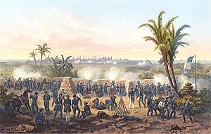
During the Mexican-American War, the port was blockaded again, this time by the Americans. Initial American attempts in 1847 to land in Alvarado were repulsed but eventually the Americans managed to land a few miles south of Veracruz, which surrendered after a 20-day siege
, defeated General Santa Anna
`s forces at the Battle of Cerro Gordo
, and marched inland through Xalapa
towards Mexico City, led by General Winfield Scott
.
The municipalities of Tuxpan and Chicontepec belonged to Puebla until 1853, when they were annexed to Veracruz to give the state its final form. In 1855, the State Government Palace was constructed. During the Reform War
, the major player was Ignacio de la Llave whose name is part of the state’s official designation. In 1858, the port became the site for the liberal government under Benito Juárez
after he was forced out of Mexico City during the Reform War. Their control of this port and its customs duties allowed liberal forces to gather resources. Conservative forces attacked the state but were repelled from both the port and Xalapa.
The Reform War wrecked Mexico’s economy and it found itself unable to pay debts it owed to Europe.As a result, Juárez cancelled Mexico's foreign debt. Spain, Britain and France, all outraged by this action, decided in October 1861 to force repayment of their loans by the occupation of the Mexican Gulf Coast. In December, Spanish troops commanded by general Manuel Gasset occupied the port of Veracruz, without any local resistance, followed a month later by French and British forces. The Spanish and the British withdrew after making deals with Juárez, but the French pushed on
to establish the reign of Maximilian I of Mexico
. However, this was short-lived and the French were expelled through Veracruz in 1866/67.
In 1863, the state was officially named Veracruz-Llave. After the French were expelled, the state government was in the port of Veracruz.In 1878, the capital was transferred to Orizaba. It was later moved to Xalapa in 1885.
By the end of the century, many infrastructure improvements, such as roads and railways (especially the Ferrocarril Interoceánico) had been completed with the major cities being Veracruz, Orizaba, Xalapa, Córdoba, Jalacingo, Chicontepec and Tantoyuca
. The discovery of oil in the north of the state attracted foreign firms, which brought machinery needed for its extraction. These companies included Huasteca Company Petroleum and El Aguila along with American and English firms. During the same time period, uprisings against the government under Porfirio Díaz
in the agricultural south of the state were brutally repressed.
ousted him from power. The major event leading up to this war in Veracruz was the cigar-makers strike of 1905, when more than 5,000 workers of the “El Valle Nacional” company walked off the job. The governor, Teodora A. Dehesa, unsuccessfully tried to negotiate a settlement. The strike went on for months until the strikers won. This victory encouraged more actions, until strikes at the factories in Rio Blanco, Nogales, Santa Rosa and Contón de Orizaba resulted in violence in 1907.
No major battle of the Mexican Revolution were fought in the state although there were skirmishes and attacks on the port. By 1914 rebel Cándido Agular occupied a number of municipalities in the state and in 1917, Venustiano Carranza
transferred the federal government here temporarily.
On April 21, 1914 an incident involving U.S. sailors in Tampico
led President Woodrow Wilson
to land American troops in Veracruz, where they remained for six months. Mexico later responded by severing diplomatic relations.
After the Revolution, agrarian reform, including the redistribution of land and the creation of ejidos took place here. The oil companies in the north of the state were nationalized and consolidated into PEMEX
in the 1930s by Lázaro Cárdenas
. In the 1950s, more road construction, such as the Mexico City- Poza Rica, Veracruz-Alvarado- Coatzacoalco and Tinajas-Ciudad Aleman-Tlacoatalpan highways were constructed. The Universidad Veracruzana
was expanded as well. In 1960, the Museum of Anthropology in Xalapa
was inaugurated as well as the Coatzacoalco-Salina Cruz
highway. The Veracruz city international airport
was opened in the 1970s.
There is about 1 million hectares of cultable land, half of which is in private hands and 43% is ejido
or communal land. The rest is occupied by human settlements. There are 3,620 ejidos parceled out to 270,000 ejido members. 52.5% of agricultural land is used for the growing of crops or used as pasture and 43.1% is forest or rainforest. Chief agricultural products include coffee, vanilla, sugarcane, tobacco, bananas, coconuts, and vegetables, but local farmers depend mainly on corn and beans. Two corn crops per year are generally produced, planted on 644,936 hectares with a production of 1,114,325 tons. The state is the leading national producer of coffee, sugarcane, corn, and rice. Coffee is grown on 152,993 hectares producing 400,575 tons. Export earnings from this crop are about 232 million USD annually. Most coffee is grown in the mountain areas of Córdoba-Huatusco, Coatepec-Teocelo-Cosautlán and Misantla-Tlapacoyan-Atzalan. Sugarcane is cultivated on 254,000 hectares, producing 16,867,958 tons annually. Veracruz is the largest producer of rice with 24,000 hectares producing 120,000 tons. Much is this crop is protected by import bans from Asia.
The state grows half of the country’s citrus fruit and grows the most kinds. This occupies 180,577 hectares and produces 2,575,140 tons annually. Varieties include oranges, tangerine
s, mandarin
s, limes and grapefruit. Most citrus is grown in the north of the state, and much of the lime crop is exported, supporting a packing and shipping industry. Veracruz is the largest mango
producer in the country, grown on 31,640 hectares producing 287,000 tons. Most of this is the manila variety, which is preferred in Mexico. 95% of this crop is consumed fresh within Mexico although exports to Canada have begun. Vanilla beans are native to the state, which is the primary producer for Mexico. Most of this crop is grown in an area known as Totonacapan in and around Papantla.
Livestock raising is an important activity. There are over 300,000 units of production most of which raise cattle, with Veracruz being the main beef producer for the country at 14% of the total. In addition to beef cattle, dairy cattle, pigs, sheep, goats, horses, domestic fowl, and bees are raised.
From the tropical forests of the inland regions come dyewoods, hardwoods, and rubber. About 20% of the state’s territory is forested, with 220,000 of temperate forest and 1,200,000 hectares of tropical forests. Logging in the state produces 128,254 m3 of wood products per year. The most exploited species include pine, oyamel, cypress and oak. Some tropical hardwoods are harvested as well.
Veracruz’s long coastline supports a large fishing industry, producing one-fifth of Mexico’s catch. Most of the country’s mojarra
, trout
, oyster
s and shrimp come from here. Other major fish catches include tilapia
, lebrancha, crab, sea bass
and huachinango .
Agroindustry focuses on the processing of coffee and sugar products, with citrus packers holding an important position as well.
The mountains contain relatively unexploited deposits of gold, silver, iron, and coal. Although Veracruz is an important source of metals such as iron and copper, a great deal of its mining involves non-metallic minerals as sulfur, silica, feldspar
, calcium
, kaolin and marble
. The state is ranked fourth in the nation for this kind of mining production. However, mining only accounts for 1.5% of economic activity for the entire state.
Veracruz was a pioneer in both the extraction and refining of petroleum products. The state has about one-fourth of Mexico’s petroleum reserves and ranks third in petroleum production. Most of this production is concentrated in the northern part of the state. Approximiately 40000000 barrels (6,359,491,800 l) of oil are produced each year and 109870000000 cubic feet (3,111,171,979.9 m³) of natural gas. Petrochemicals represent 28.1% of the state’s manufacturing and ranks first nationally. There are 22 petrochemical plants, with the most important being La Cangrejera, Jaltipan de Morelos
, Poza Rica
, Cosoleacaque
, Pajaritos and Minatitlán
.
, Minatitlán, Cosoleacaque, Poza Rica, Córdoba, Orizaba, Tuxpan and Veracruz, with over 5,000 establishments. The rest is divided among nearly 11,000 smaller establishments. There are five major industrial parks:Bruno Pagliai, Ixtac, Petroquimico Morelos, Córdoba-Amatlán and Parque 2000. The largest of these is Bruno Pagliai, which covers 300.8 hectares.
Transportation and commerce are important factors in the state, mostly linked to importing and exporting through its four deepwater ports. The focus of most of these activities is the port of Veracruz. It has the most favored position on Mexico’s Gulf coast and is extensively used for exports to the United States, Latin America and Europe. Seventy-five percent of all port activity in Mexico takes place in Veracruz. The chief exports of this state are coffee, fresh fruits, fertilizer, sugar, fish and crustaceans. Other ports include those in Tuxpan and Coatzacoalcos. Most highway, rail and air connections link to the port of Veracruz and other ports to the south. The state has 73 companies that have been classified as high-volume exporters and it is ranked sixth in the country for exports. The state contains five major food wholesale markets, 146 government sponsored markets, about 75,000 private stores and 201 supermarkets. Wholesale vendors focus on agricultural products such as wood, livestock and food products. The major focal point for international business is the World Trade Center EXPOVER in Boca del Río. Inaugurated in 1989, the center has facilities to accommodate 5,000 people in 7,000 m2, a exhibition hall of 12,000m2, a business center and parking for over 800 vehicles.
Ceramics have been made in almost all parts of Veracruz since the Olmecs. One area known for its work is Papantla which also includes life sized representations of folk dancers from the area along with more mundane items of glazed and unglazed pottery. Minatitlán is known for its production of ceramic cooking utensils which are also popular in the neighborhing municipalities of Actopan and Naolinco. San Miguel Aguasuelos and Jalcomulco are known for their white clay wares which include water jars, toys, nativity scenes, bells and more.
Traditional clothing and embroidery can be most easily found the La Huasteca area, which elaboratly decorated women's blouses can be seen, especially in the El Higo and Tlalixcoyan area. In Totonacalpan, men are still often seen in white shirts and pants with a bag to hold personal items. This dress dates back to the early colonial period and had not changed much since then. Other areas specialize in wool items such as Naranjos de Amatlán, Minatilán and the city of Veracruz where items such as dresses, skirts and jackets. These and other textils such as tablecloths and napkins are often decorated with cross-stich. Leather items include shoes, jackets, bags, wallets, belts and boots and are usually made in the La Huasteca region, Teocolo, Citlaltépetl and Naolinco.
. Another important native contribution is seafood, which is feature in many dishes such as arroz a la tumbada and caldo de mariscos (seafood soup) .
After the Conquest and during the colonial period, many other spices and ingredients were brought and have had a greater influence in the cooking here than in other parts of the country. From Europe, the Spanish brought saffron
, parsley
, thyme
, marjoram
, bay laurel
and cilantro as well Asian spices such as cloves, cinnamon
and black pepper
. The Spaniards also brought wheat, rice, almonds, olives and olive oil, garlic and capers. The latter three are essential ingredients in what is perhaps the most famous specialty of the region, huachinango a la veracruzana, red snapper in a spicy tomato sauce.Caribbean imports such as sugar cane and pineapple were adapted as well as the peanut, brought from Africa by the Portuguese via Brazil. Other African ingredients include plantain
s, yucca
and sweet potato
es.
Veracruz cuisine divides into six regions called Sotavento, Centro Norte, Centro Sur, Sierra and Costa Norte and Los Tuxtlas. The Sotovento area is in the south of the state, and the dishes here are heavily based on rice. Common dishes include arroz a la tumbada, which is rice cooked with seafood or meat and rice with fried bananas. Seafood dishes are also prominent based mostly on fish and shrimp. A common ingredient in dishes is a herb called “hoja santa” or “hierba Santa,” which is a plant of the Piperaceae
family. The Centro Norte is centered on Xalapa. Dishes here tend to be more indigenous in nature, heavily flavored with mild chili peppers. Common dishes here include Chilehuates, similar to a tamale, stuffed chile peppers, and enchiladas. Less seafood and more pork and domestic fowl are consumed. The Centro Sur area is mostly indigenous and encompasses the area of , Huatusco, Coscomatepec, Cotaxtla, Orizaba, Amatlán, Huilango y las españolas Córdoba y Fortín de las Flores, la negra Yanga and San Lorenzo de los Negros. Dishes here are similar to Centro Norte, but chayote
s appear more often as this region is a major producer of the vegetable. Meats in adobo
sauce are common as well. The Sierra and Costa Norte encompass the northern part of the state, such as the Pánuco River area and Totonacapan. This area is noted for a number of unique dishes such as frijoles en achuchutl, made with black beans, pork rind, chayotes, squash seeds and jalapeño peppers. Bocoles are a kind of filled tortilla made with corn dough, stuffed with black beans, chorizo, eggs or seafood, which are then fried in lard. Tamales are often made with banana leaves. The area is also known for its breads, especially anise –flavored rolls. The Los Tuxtlas area is centered on the communities of Santiago, San Andrés and Catemaco, which were the center of the Olmec civilization. The cuisine in this area features yucca, “chocos” (a type edible flower), fish, especially mojarra, and exotic meats such as monkey, and iguana
.
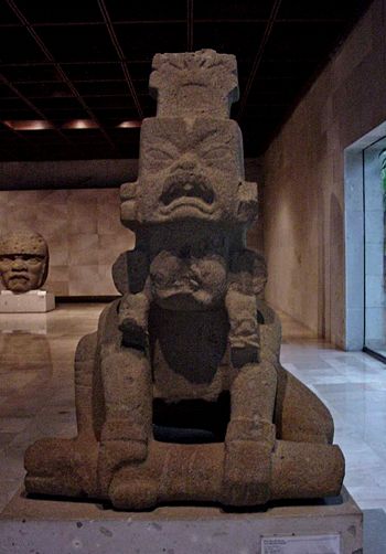 The state capital of Xalapa is also home to a number of important museums. The Museum of Anthropology contains the second most important collection of Mesoamerican artifacts in the country. It was built beginning in 1959 over six hectares. The complex is divided into to various halls and galleries by theme, focusing on the Olmec and Totonaca cultures. The Patio Olmeca contains the colossal head found in 1945 and known as El Rey (The King). Other important artifacts include giant stelae and a figure of an Olmec Jaguar-King. The Museum of Science and Technology is in Xalapa. It contains more than 400 exhibitions in eight halls: Life, Ecology, Space, Transportation, Sciences, Energy, Water and Earth. The Pinoteca Diega Rivera was established by the state in the former Monastery of San Francisco in Xalapa. Its primary function is to preserve and display of Rivera
’s works owned by the state, but it also contains early works by José María Velasco
, Jorge Cuesta
and Teodoro A. Dehesa. Near the city is the Hacienda del Lencero, which was the home and headquarters of President Antonio López de Santa Anna in the 19th century. It has been preserved and turned into a museum.
In Tuxpan is the Regional Museum of Anthropologywith more than 400 pieces from pre-Hispanic groups in the region, displayed in four halls. Most of the pieces come from the center of the state and from the Huasteca region.On the edge of the Tuxpan River.The city also has the Mexican-Cuban Museum. It contains a collection of photographs from the Cuban Revolution
as well as a statue of José Martí
.
Other museums are scattered in other parts of the state. The Salvador Ferrando
Museum is located in Tlacotalpan and contains many everyday items and art from the 16th to the 19th centuries.The Tuxteco Regional Museum in Santiago de Tuxtla contains Olmec and Totonaca artifacts including art objects, farming implements, utensils and more. In the garden area, there are giant stone sculptures from the Tres Zapotes site. The Jardín Central (Central Garden) of the municipality of Tierra Blanca
has a number of Totonaca archeological pieces on display. The Archeological Museum of Córdoba is in the city of the same name with three exhibition halls containing artifacts from the Maya, Olmec, Toltec and Huastec cultures. There is also a collection ofhistorical photographs of the city. The Veracruz State Art Museum (Museo de Arte del Estado de Veracruz) is located in Orizaba in what was the monastery associated with the Concordia Church. Its collection includes works by Diego Rivera, Ignacio Rosas and Gonzalo Argüelles. It also contains a collection of historical photographs related to Veracruz and art. The Malintzin Archeological Museum in isn the municipality of Nogales
. It is a small museum with one hall, with photographs and documents. It is located in the church where Malinche and Juan de Jaramillo were supposedly married.
in the city of Veracruz. This city’s version of the event begins with the “burning of bad humor,” which is represented in effigy. A number of Kings and Queens are coronated including categories for chileren bu the most important is the Rey Feo (Ugly King) and the Reina del Carnaval (Queen of the Carnival). The latter is accompanies by cadets from the Naval Academy during the parade. This celebration is repeated all along the Veracruz coastline with other significant festivities taking place in Alvarado
, Coatzacoalcos
, San Rafael
and Villa José Cardel
. Minatitlán
's celebration draws people from the nearby states of Oaxaca and Tabasco. Day of the Dead
is celebrated in almost all of Mexico from 31 Oct to 2 November but there are local twists in the state. In some places, it is commemorated during the months of August and September. In Papantla, boards or tables are placed on rooftops, which have been adorned with flowers, plant matter and more. In Tantoyuca, it is commemorated with costumes and music, similar to Carnival.
The Christian celebration of Candlemas is fused with traditions associated with Chalchiuhtlicua, the goddess of water, rivers, lakes and ocean. She was replaced by the Virgin of Candlemas, the protector of fishermen, making this celebration particularly important on the coast, especially in Tlacotalpan, where it is celebrated with much pomp. In Jaltipan de Morelos
, ethnic Nahuas and Popolucas dress in elaborate costumes and arrange their hair in intricate styles. In Santa María Magdalena, on 22 July, bulls are set free to roam on the streets. Corn harvest festivals are prominent in the Huasteca region in municipalities such as Chontla
, Chicontepec, and Ixhuatlán de Madero
. These generally include native dances and foods based on corn.
is a dance brought over from Spanish. Today the state has two varieties: the jarocho and the huasteco. Indigenous and folk dances in the state are most often associated with rituals and religious festivals. These include one called Los Lisceres also called the Tigres from the Los Tuxtlas region. Participants wear Olmec style masks which represent the rain god Tlalóc. Another is Los Guaguas in which the participants pay homage to the sun, and Los Santiagos, which is related to the veneration of Saint James, patron saint of Hernán Cortés. One last one is called Los Negritos (The Little Black Ones) which was created by African slaves. According to tradition, the origin of this dance lies in a story about a boy who was bitten by a snake and the rituals his family held to heal him.
However, the state’s most famous dance is as much a ritual and daredevil act as movements performed to music. The Danza de los Voladores (Dance of the Flyers) is a ceremony/ritual which has its roots in the pre-Hispanic period and presently best known as associated with the town of Papantla, Veracruz. It is believed to have originated with the Nahua, Huastec and Otomi
peoples in central Mexico, and then spread throughout most of Mesoamerica
. The ritual consists of dance and the climbing of a 30 meter pole from which four of the five participants then launch themselves tied with ropes to descend to the ground. The fifth remains on top of the pole, dancing and playing a flute and drum. According to myth, the ritual was created to ask the gods to end a severe drought
. Although the ritual did not originate with the Totonac
people, today it is most strongly associated with them, especially those in and around Papantla, as the ceremony has died off in most other places. The ceremony was named an Intangible Cultural Heritage
by UNESCO
in order to help the ritual survive and thrive in the modern world.
The state's best-known musical style is called the "son". A “son
” is a musical variation which traces its origins to Spain and developed during the 17th and 18th centuries. It is the state’s most popular musical style shows influences from the many peoples who have lived here such as indigenous groups, Portuguese, Italians, Africans, French and others. The music is generally performed by harps, violins and guitars, with an occasional wind instrument. Son huasteco (also called son huapango)
is a variety of son played in the north of the state mostly among the Totonaca. Son jarocho is the better known and more popular variety played in the south of the state.
The state has produced a number of musicians famous in the country. One of the best known is Francisco Gabilondo Soler. Gabilondo Soler is best known for creating a character known as “Cri-cri”, a singing cricket for a radio show in the first half of the 20th century. As a musician, he specialized in writing children’s songs such as “Abuelito,” “Caminito de la escuela,” “El baile de los muñecos,” “El burrito” and “La negrita Cucurumbé.” A number of his works have been translated into other languages. Another famous musician is Agustín Lara, who has had more international fame. Nicknamed “Flaco de oro” (golden skinny one), he always insisted that he was born in Tlacotalpan, Veracruz and not Mexico City as records show. Lara formed his first band in 1930 called El Son de Marabú and toured almost continuously in Mexico and abroad during his career. His most famous compositions include “Veracruz,” “Noche de Ronda” and “Solamente una vez.” Other prominent musicians include Toña “La Negra” or María Antonia del Carmen Peregino, Narcisco Serradel, Lorenzo Barcelata and María Greever.
), Natal Pesado and Ignacio Rosas.
However, most of Veracruz’s best-known artists are from the 19th and 20th centuries. In the 19th century, these include Miguel Mata Reyes, Salvador Ferrando
, José María Jara
, Enrique Guerra
and Alberto Fuster. Miguel Mata Reyes is best known for his contributions to the design of the Palacio de Bellas Artes as well a portrait of Antonio López de Santa Anna
. Salvador Ferrando was a portrait and landscape artist from the north of the state. Until recently, most of his work had been hidden in a museum named after him in the Tlacotalpan region. Much of it now is on display at the Museo de Arte de Veracruz in Orizaba. José María Jara is noted for his paintings of Veracruz customs, whose works include El Velorio, which was presented at the World’s Fair in Paris. Enrique Guerra was an important sculptor at the end of the 19th century. His best-known works are bas reliefs and include Asesinato de César, Coroliano, Thais and Crisálida. Alberto Fuster was most active at the end of the century and is noted for bringing symbolism painting to Mexico from his stay in Europe. His works include El progreso, Safo en el templo de Delfos and Nativa con loro.
There are three important artists from the 20th century, Carlos Bracho, Norberto Martínez and Teodoro Cano García
. Active in the first half of the century, sculptor Carlos Bracho’s work has been compared to that of Juan Rulfo
. His works have been done in plaster, bronze, terracotta and green onyx and include monumental works which can be found in the cities of Xalapa, Puebla
, Pachuca
and Mexico City. His best-known works are El abrazo, Cabeza verda and El campesino se apodera de la tierra. Norberto Martínez only lived 45 years but is considered one of the most prolific of Mexican painters who dedicated most of his works to social themes. A number of these are early murals such as El comercio in the Jáuregi de Xalapa market as well as an untitled work in a private home in Córdoba which deals with the fusion of the Spanish, indigenous and African races in Mexico. Later works include the three murals in the main stairwell of the School of Law at the University of Xalapa and El hombre y el conocimiento at the Universidad Veracruzana
. Teodoro Cano García is one of Mexico’s most famous muralists of the late 20th century, famous for the promotion of the Totonaca culture of his hometown of Papantla. He has created paintings, sculptures, etchings, photography and mixed media works with his murals and sculptures most acclaimed. Examples of his work can be seen in various parts of public buildings in Papantla.
Most of Veracruz’s older architecture can be found in the inland cities of Xalapa and Córdoba. Despite being the first Spanish settlement, the city of Veracruz lost most its older structures to the various invasions it has suffered. Architecture from the 16th to the 19th century includes colonial Spanish, Moorish, Neo gothic and Neoclassical. From the 20th century on, a number of names stand out. Armando Bravo Ramirez remodeled the State Government Palace and the facade of the Capillas de Animas, both in Xalapa. Other prominent names responsible for many projects in the state include Luís Gonzalez Aparicio, Bernal Lascuraín Rangel and Luis Manuel Tello Deschamps.
is one of Veracruz’s most-distinguished poets. Over his lifetime from the latter 19th to early 20th centuries, he worked as a professor, politician and journalist contributing to periodicals such as El Veracruzano, El Orden, and el Imparcial. His creative works include some of the first Romantic pieces produced in Mexico such as Oda a Victor Hugo, Ojos verdes, Gloria and Voces interiors. Other works include Poesías A Tirsa, Nox (also known as Claudia) and his last works such as Al buen cura and La mujer de nieve. He became a member of the Academia Mexicana de la Lengua
and is buried at the Rotonda de los Hombres Ilustres in Mexico City. María Enriqueta Camarillo y Roa was one of a number of women writers to gain prominence in Mexico at the end of the 19th century. While she wrote a number of works such as Jirón del mundo, Sorpresas de la vida and El Secreto, she is best known for Rosas de la infancia, with which many Mexicans learned to read.
Writers born at the end of the 19th century, such as Gregorio López y Fuentes, Manuel Maples Arce
and Jorge Mateo Cuesta Porte-Petit were often concerned with social issues. Works of this type include El Indio by López, Metropolis by Maples and a poem called Canto a un dios mineral by Cuesta. The following generation, born in the first decades of the 20th century, became known as the Generation of the 1950s. During this time Veracruz’s literary tradition consolidated and decided to break type. One example is Juan Hernández Ramírez’s writing of poetry in the Nahuatl
spoken in the La Huasteca
area of Veracruz. One important name from this generation is Emilio Carballido
who wrote about 100 plays as well as scripts for radio and television. Some of his works include Rosalba y los llaveros, Felicidad and Las visitaciones del Diablo. In 1996, he won the Premio Nacional de Literatura and in 2002 he received the Ariel de Oro for his work in cinema.
 Public education in the state is supervised by the state Direción General de Educación Popular and the Dirección General de Educación Media Superior y Superior. The current system is the result of a number of reforms which took place in the 1980s and 1990s. In the late 1990s, 302 new school campuses were created statewide and 257 schools were remodeled. These included new schools for special education, distance learning and technological institutes, giving the state one of the highest number of school campuses in the country. There are a total of 20,479 schools, with nearly 2 million students and about 85,000 teachers. 93% of schools are in the basic education category (preschool, primary and middle schools. Preschools also include those geared towards the indigenous populations, focusing on bilingual and bicultural education in both the indigenous language/culture and Spanish. One major focus of these and other schools is to eliminate illiteracy in indigenous communities. The “Medio Superior” level includes vocational high school and technical colleges. These account for 6.6% of schools in the public system. The Superior level includes teachers’ colleges and universities. There are 166 institutes at this level, with about 68,000 students studying 221 different majors. There are also 63 master’s degree programs and six PhDs. These institutions serve about 135,000 students accounting for about 19% of the college-aged population (19–24 year olds), slightly below the national average of 24%.
The major state university is the Universidad Veracruzana
, with offers 56 bachelor’s degrees, 37 masters and 5 PhDs. It is based in the capital of Xalapa and is noted for is large and varied sports programs. There are campuses in fourteen other cities. About 37% of university students attend the main public university, with a student population of 47,000 undergraduates and 2,000 postgraduates. Other important schools include Instituto Tecnologico de Veracruz in Veracruz, Universidad Anáhuac in Xalapa, Universidad de Xalapa in Xalapa, ITESM in Córdoba, Universidad Cristóbal Colón in Veracruz, the Veracruz Naval Academy and the Instituto Tecnológico del Mar.
and Europe. The state has indigenous cultural influences mixed with those from Europe, Africa and the Afro-Caribbean. These can be best seen in the music, the culinary traditions and in the people themselves.
The number of ethnic communities in the state has been calculated at 2,062. The most numerous include the Nahuas, Totonacas, Huastecas, Popolucas, Zapotecas, Chinantecas, Otomis, Mazatecas, Tepehuas, Mixtecas, Zoques, Mixe
s, Mayas and Tzotzils, all indigenous groups. The largest are Nahuas, who make up over half of the indigenous population. Most native communities can be found in 68 municipalities especially in Tehuipango
, Mixtla de Altamirano
, Astacinga
, Soledad Atzompa
, Atlahuilco
, Tequila
, Tlaquilpan, Los Reyes, Magdalena, San Andres Tenejapan, Tantoyuca, Zongolica, Chicontepec, Papantla, Ixhuatlán de Madero, Soteapan, Playa Vicente, Mecayapan y Coyutla, Benito Juárez, Coxquihi, Espinal, Filomeno Mata, Ixcatepec, Mecatlán and Zozocolco de Hidalgo. As of 1998, about 10% of the population spoke an indigenous language; however, this does not take into account all indigenous peoples. The census of 2005 counted 605,135 as speaking an indigenous language.
There are also small immigrant communities of Spaniards, Italians, Basque and Lebanese
. African slaves were imported to Mexico through the Veracruz port. At one point, they outnumbered Europeans and a significant number ran away from haciendas and plantations to form their own communities, sometimes allied with indigenous groups. One such rebellion was led by Yanga, who successfully negotiated a free African community with Spanish authorities in 1609. Like other groups, many of African descent would intermarry with other groups, with the category of “mulatto” existing in the old colonial caste system for those with African blood. Today, the vast majority of Afro Mexicans in Veracruz and other parts of the country are spread out and intermixed with the rest of the population.
With a population of 7,110,214 (2005), Veracruz is the third most populous entity in the country, after the Federal District of Mexico City and the State of Mexico. Population growth has slowed in the state in the last decades, due to lower birthrates and the exodus of migrants, mostly men. Women outnumber men. One reason for the decline in birthrates is the elevation of education levels, especially among women. Another is urbanization, with about one third of the state’s population living in urban centers, especially Veracruz, Xalapa, Coatzacoalcos, Minatitlán and Papantla. Most (90%) of the state’s communities, outside of municipal seats have fewer than 500 people and contain only 21% of the total population. The migration of men outside the state has put more women into the state's workforce. Approximately 75% of the population is under 45 years of age and 30% under the age of 14.
Life expectancy is just under the norm for the rest of the country. The overwhelming majority of people in the state are Catholic, however, there is a significant Protestant minority and a number who profess the Jewish faith.
To the north of the port city is the Sierra or Totonacalpan area of the state, home to the Totonaca people. This is home to the important pre-Hispanic city of El Tajín
and the present-day city of Papantla
. The modern city is best known as the home of the Totonac version of the “danza de voladores
”; there, the dancers spin from 80 ft (24.4 m) high poles. The area is also the native habitat of the vanilla bean.
To the south of the port is on the coast, is Catemaco. This is in a tropical area. The area’s two main features are Lake Catemaco, which is located in the crater of an extinct volcano and Isla Tanaxpillo just off the coast. This island is also called the island of the monkeys or baboons due to a group of feral monkeys that escaped and found refuge here.
Inland is the coffee-growing region in and around the cities of Coatepec and Xalapa. Orizaba is best known for the volcano nearby but also has a large waterfall called El Elefante and a Cañon (Canyon) de Río Blanco.
, Totonac
, and Huastec
cities. El Tajín, a ruined city that reached its apex between the 9th and 13th centuries ad, was designated a UNESCO World Heritage site in 1992.
El Zapotal is an archeological site which was discovered in 1971 in a region known at Mixtequlla (between the Blanco and Papaloapan Rivers). This site is noted for its clay figurines with smiling faces, part of an extremely large offering in honor of the god of death Mictlantecuhtli
.
Cempoala is an archeological site located on the coast between the modern settlements of La Antigua and Ciudad Cardel. It was occupied when Hernán Cortés arrived, and he managed to form an alliance with the Totonacs here against the Aztecs. In the center of the site, there is a large plaza surrounded by temples and the palace of the Totonac chief. The site also has a small museum.
 Quiahuiztlán is on the coast on a small mountain named Bernal. It is cut into the mountain as a series of terraces. It is located very close to where Cortés founded the initial Spanish settlement of Villa Rica de la Vera-Cruz.
The Castillo de Teayo (Teayo Castle) is really a pyramid, whose original name was Zapotitlán. It is located on the border between Huasctec and Totonaca lands. It was abandoned in the 19th century.
The largest and most important site is El Tajín
, located near the city of Papantla. The name is from the Totonac language and means “thunder,” but no one knows what the true name of this city was. It is also unknown if the Totonac built it, but since they have dominated the region for centuries, they lay claim to it.The city developed from the end of the Classic period and the beginning of the Post Classic period, between 800 and 1150 C.E. It is divided into five zones, the Plaza del Arroyo Group, the Central Zone, the Gran Xicalcoliuhqui, Tajín Chico and the Column Complex. Its signature building is the Pyramid of the Niches, named after the 365 niches built into the levels of the structure. The site has a large number of Mesoamerican ball game courts, one with details reliefs showing the beheading of a ballplayer and his role in the afterlife.
The Tres Zapotes site is located community of the same name. Covering 1.5 hectares, the main building has a square base, which is surrounded by gardens and trees. The most important find from his is Stele “C” which is on display at the Museo Nacional de Antropología
in Mexico City.
El Pital is a site in the municipality of Martínez de la Torre
. It consists of a mound with a pyramid base and stairs on the east side.The site’s culture is considered to be a link between the coastal and highland cultures of the region.
Los Idolos is a site in the municipal city of Misantla
, and was an important ceremonial site for the Totonacapan region. It consists of four rectangular patios linked by platforms and flat-topped mounds. Many of the structures are decorated with smooth river stone, thought to have come from the Misantla River.
The Centro Ceremonial Cuajilote is located on the Bobos River
. It consists of a large plaza 400 meters long lined with structures. In the center of the plaza there are three shrines, one of which contains phallic figures.
, each of which is headquartered in a prominent city, town, or village. The newest of these are the municipalities of San Rafael
and Santiago Sochiapan
which were created in 2003. These municipalities are grouped into regions called Huasteca Alta (with ten municipalities), Huasteca Baja (with 23 municipalities), Totonaca (with 15 municipalities), Nautla (with 11 municipalities), Capital (with 33 municipalities), Sotavento (with 12 municipalities), De las Montañas (with 57 municipalities), Papaloapan (with 22 municipalities), De los Tuxtlas (with four municipalities) and Olmeca (with 25 municipalities) .
The state contains 1675.3 km (1,041 mi) of railway. Most of this is conceded by the federal government to private companies, with strategic stretches maintained directly by the government. Some of the private companies include Kansas City Southern de México and Ferrosur. These lines are used almost exclusively for the transportation of freight, which in 1999 added up to 37 million tons. Three rail line serve the port of Veracruz exclusively. One is dedicated to the port of Coatzacalcos.
The ports of Veracruz are Tuxpan, Veracruz, Coatzacalcos, Pajaritos, Minatitlán-Nanchital, Tecolutla, Nautla
, Alvarado and Tlacotalpan. The first three are the ports for heavy cargo ships, with Veracruz the most important of the three. The others are small ports for small ships, fishing boats and tourism. All ports are operated privately with the exception of Pajaritos, which is operated by PEMEX
. Port traffic in Veracruz account for 10% of all commercial traffic in the country, 23.4% of the port traffic of Mexico and 21% of all port traffic in the Gulf of Mexico and Caribbean. Goods imported through the state reach 16 out of Mexico’s 31 states plus Mexico City. The port of Veracruz alone handles over 12 million tons of freight per year. Coatzacoalcos is important for its handling of petroleum products.
The state contains three major airports. “El Tajín” in Tihuatlán serving Poza Rica and “Canticas” in Minatitlán provide national service. “Heriberto Jara Corona” in the city of Veracruz provides national and international service. There are also 31 smaller regional airfields in municipalities such as Acayucán , Cazones de Herrera
, Córdoba, Cuitlahuac
, Juán Rodríguez Clara
, Ozuluama
, Platón Sánchez
, Playa Vicente
, Soconusco
, Tamalín
, Tamiahua
, Tecolutla, Temapache
, Tempoal
and Tierra Blanca.
There are 59 local newspapers and 40 magazines published in the state. These include the Diario de Xalapa, El Dictamen, El Sol del Centro and la Opinión de Minatitlán. There are 202 radio stations (57 AM, 35 FM). Most are commercial or private but some are operated by non-profits and governmental agencies. There are 22 television stations; two channels are local, and the rest are repeaters from national broadcasters. Five companies provide cable and satellite television. Telmex
controls over 75% of the telephone service in the state.
Mexico City
Mexico City is the Federal District , capital of Mexico and seat of the federal powers of the Mexican Union. It is a federal entity within Mexico which is not part of any one of the 31 Mexican states but belongs to the federation as a whole...
, comprise the 32 federative entities of Mexico
Mexico
The United Mexican States , commonly known as Mexico , is a federal constitutional republic in North America. It is bordered on the north by the United States; on the south and west by the Pacific Ocean; on the southeast by Guatemala, Belize, and the Caribbean Sea; and on the east by the Gulf of...
. It is divided in 212 municipalities
Municipalities of Veracruz
The Mexican state of Veracruz is subdivided into 212 municipalities :-External links:* *...
and its capital city is Xalapa-Enríquez
Xalapa
Xalapa-Enríquez, commonly Xalapa or Jalapa, is the capital city of the Mexican state of Veracruz and the name of the surrounding municipality. In the year 2005 census the city reported a population of 387,879 and the municipality of which it serves as municipal seat reported a population of...
.
It is located in Eastern Mexico
Eastern Mexico
The Eastern Mexico or also called East-Central Mexico , is a region of United Mexican States, formed by the states of Hidalgo, Puebla, Tlaxcala and Veracruz...
. It is bordered by the states of Tamaulipas
Tamaulipas
Tamaulipas officially Estado Libre y Soberano de Tamaulipas is one of the 31 states which, with the Federal District, comprise the 32 Federal Entities of Mexico. It is divided in 43 municipalities and its capital city is Ciudad Victoria. The capital city was named after Guadalupe Victoria, the...
to the north, San Luis Potosi
San Luis Potosí
San Luis Potosí officially Estado Libre y Soberano de San Luis Potosí is one of the 31 states which, with the Federal District, comprise the 32 Federal Entities of Mexico. It is divided in 58 municipalities and its capital city is San Luis Potosí....
and Hidalgo to the west, Puebla
Puebla
Puebla officially Estado Libre y Soberano de Puebla is one of the 31 states which, with the Federal District, comprise the 32 Federal Entities of Mexico. It is divided in 217 municipalities and its capital city is Puebla....
to the southwest, Oaxaca
Oaxaca
Oaxaca , , officially Estado Libre y Soberano de Oaxaca is one of the 31 states which, along with the Federal District, comprise the 32 federative entities of Mexico. It is divided into 571 municipalities; of which 418 are governed by the system of customs and traditions...
and Chiapas
Chiapas
Chiapas officially Estado Libre y Soberano de Chiapas is one of the 31 states that, with the Federal District, comprise the 32 Federal Entities of Mexico. It is divided in 118 municipalities and its capital city is Tuxtla Gutierrez. Other important cites in Chiapas include San Cristóbal de las...
to the south and Tabasco
Tabasco
Tabasco officially Estado Libre y Soberano de Tabasco is one of the 31 states which, with the Federal District, comprise the 32 Federal Entities of Mexico. It is divided in 17 municipalities and its capital city is Villahermosa....
to the southeast. To the east, Veracruz has a significant share of coastline on the Gulf of Mexico
Gulf of Mexico
The Gulf of Mexico is a partially landlocked ocean basin largely surrounded by the North American continent and the island of Cuba. It is bounded on the northeast, north and northwest by the Gulf Coast of the United States, on the southwest and south by Mexico, and on the southeast by Cuba. In...
.
The state is noted for its mixed ethnic and large indigenous populations. Its cuisine reflects the many cultural influences that have come through the state because of the importance of the port of Veracruz.
In addition to the capital city, the state's largest cities include Veracruz
Veracruz, Veracruz
Veracruz, officially known as Heroica Veracruz, is a major port city and municipality on the Gulf of Mexico in the Mexican state of Veracruz. The city is located in the central part of the state. It is located along Federal Highway 140 from the state capital Xalapa, and is the state's most...
, Coatzacoalcos
Coatzacoalcos
Coatzacoalcos is a major port city in the southern part of the Mexican state of Veracruz, on the Coatzacoalcos River. Coatzacoalcos comes from an indigenous word meaning "Site of the Snake" or "Where the snake hides"...
, Córdoba
Córdoba, Veracruz
Córdoba, officially known as Heroica Córdoba, is a city and the seat of the municipality of the same name in the Mexican state of Veracruz. It was founded in 1618....
, Minatitlán
Minatitlán, Veracruz
Minatitlán is a city in southeastern Mexican state of Veracruz in the Olmec region of the state and the north of the Isthmus of Tehuantepec.In 2010 the greater metropolitan area had a population of 356,020...
, Poza Rica, Boca Del Río
Boca del Río, Veracruz
Boca del Río is a city and municipality located in the center of the state of Veracruz. The small city of Boca del Río serves as the seat of the municipality. The municipality lies just south of Veracruz Municipality, and contains a part of the city and port of Veracruz, Mexico...
and Orizaba
Orizaba
Orizaba is a city and municipality in the Mexican state of Veracruz. It is located 20 km west of its sister city Córdoba, and is adjacent to Río Blanco and Ixtaczoquitlán, on Federal Highways 180 and 190. The city had a 2005 census population of 117,273 and is almost coextensive with its small...
.
Etymology
The full name of the state is Veracruz de Ignacio de la Llave. Veracruz was named after the city of VeracruzVeracruz, Veracruz
Veracruz, officially known as Heroica Veracruz, is a major port city and municipality on the Gulf of Mexico in the Mexican state of Veracruz. The city is located in the central part of the state. It is located along Federal Highway 140 from the state capital Xalapa, and is the state's most...
(in English, literally: "True Cross
True Cross
The True Cross is the name for physical remnants which, by a Christian tradition, are believed to be from the cross upon which Jesus was crucified.According to post-Nicene historians, Socrates Scholasticus and others, the Empress Helena The True Cross is the name for physical remnants which, by a...
"), which was originally called the Villa Rica de la Vera Cruz. The suffix is in honor of Ignacio de la Llave y Segura Zevallos
Ignacio de la Llave
Ignacio de la Llave y Segura Zevallos was a general and the governor of the Mexican state of Veracruz from 1861 to 1862. He was born in Orizaba, Veracruz, a nephew of Dr. Pablo de la Llave...
(1818–1863), who was the governor of the Veracruz from 1861 to 1862. The state’s seal was authorized by the state legislature in 1954, adapting the one used for the port of Veracruz.
Political geography
The state is a crescent-shaped strip of land wedged between the Sierra Madre OrientalSierra Madre Oriental
The Sierra Madre Oriental is a mountain range in northeastern Mexico.-Setting:Spanning the Sierra Madre Oriental runs from Coahuila south through Nuevo León, southwest Tamaulipas, San Luis Potosí, Querétaro, and Hidalgo to northern Puebla, where it joins with the east-west running Eje Volcánico...
to the west and the Gulf of Mexico
Gulf of Mexico
The Gulf of Mexico is a partially landlocked ocean basin largely surrounded by the North American continent and the island of Cuba. It is bounded on the northeast, north and northwest by the Gulf Coast of the United States, on the southwest and south by Mexico, and on the southeast by Cuba. In...
to the east. Its total area is 78815 square kilometre, accounting for about 3.7% of Mexico’s total territory. It stretches about 650 km (403.9 mi) north to south, but its width varies from between 212 km (131.7 mi) to 36 km (22.4 mi), with an average of about 100 km (62.1 mi) in width. Veracruz shares common borders with the states of Tamaulipas
Tamaulipas
Tamaulipas officially Estado Libre y Soberano de Tamaulipas is one of the 31 states which, with the Federal District, comprise the 32 Federal Entities of Mexico. It is divided in 43 municipalities and its capital city is Ciudad Victoria. The capital city was named after Guadalupe Victoria, the...
(to the north), Oaxaca
Oaxaca
Oaxaca , , officially Estado Libre y Soberano de Oaxaca is one of the 31 states which, along with the Federal District, comprise the 32 federative entities of Mexico. It is divided into 571 municipalities; of which 418 are governed by the system of customs and traditions...
and Chiapas
Chiapas
Chiapas officially Estado Libre y Soberano de Chiapas is one of the 31 states that, with the Federal District, comprise the 32 Federal Entities of Mexico. It is divided in 118 municipalities and its capital city is Tuxtla Gutierrez. Other important cites in Chiapas include San Cristóbal de las...
(to the south), Tabasco
Tabasco
Tabasco officially Estado Libre y Soberano de Tabasco is one of the 31 states which, with the Federal District, comprise the 32 Federal Entities of Mexico. It is divided in 17 municipalities and its capital city is Villahermosa....
(to the southeast), and Puebla
Puebla
Puebla officially Estado Libre y Soberano de Puebla is one of the 31 states which, with the Federal District, comprise the 32 Federal Entities of Mexico. It is divided in 217 municipalities and its capital city is Puebla....
, Hidalgo, and San Luis Potosí
San Luis Potosí
San Luis Potosí officially Estado Libre y Soberano de San Luis Potosí is one of the 31 states which, with the Federal District, comprise the 32 Federal Entities of Mexico. It is divided in 58 municipalities and its capital city is San Luis Potosí....
(on the west). Veracruz has 690 km (428.7 mi) of coastline with the Gulf of Mexico.
Natural geography
The natural geography can be categoried into nine regions: The Sierra de Zongolica, the Tecolutla Region, the Huayacocotla Region, the Metlac River area, the Tuxtlas Region, the Central Region, the Laguna del Castillo Region, the Pueblo Viejo-Tamiahua Region and the Laguna de Alvarado Region. The topography changes drastically, rising from the narrow coastal plains to the highlands of the eastern Sierra Madre. Elevation varies from sea level to the Pico de OrizabaPico de Orizaba
The Pico de Orizaba, or Citlaltépetl , is a stratovolcano, the highest mountain in Mexico and the third highest in North America. It rises above sea level in the eastern end of the Trans-Mexican Volcanic Belt, on the border between the states of Veracruz and Puebla...
, Mexico’s highest peak at 5610 m (18,405.5 ft) above sea level. The coast consists of low sandy strips interspersed with tidewater streams and lagoons. Most of the long coastline is narrow and sandy with unstable dunes, small shifting lagoons and points. The mountains are of the Sierra Madre Oriental and the Trans-Mexican Volcanic Belt
Trans-Mexican volcanic belt
The Trans-Mexican Volcanic Belt also known as the Transvolcanic Belt and locally as the Sierra Nevada , is a volcanic belt that extends 900 km from west to east across central-southern Mexico...
. Mountain ranges include the Sierra de Topila, Sierra de Otontepec, Sierra de Huayacocotla, Sierra de Coxquihui, Sierra de Chiconquiaco, Sierra de Jalacingo, Sierra de Axocuapan, Sierra de Huatusco, Sierra de Zongolica and the Sierra de Los Tuxtla. Major peaks include Pico de Orizaba (5700 m (18,700.8 ft)), Cofre de Perote
Cofre de Perote
Cofre de Perote, originally Naupa-Tecutépetl , is known also as Nauhcampatépetl. Both Nahuatl names mean something like 'Place of Four Mountain' or 'Mountain of the Lord of Four Places'...
(4282 m (14,048.6 ft)), Cerro de Tecomates (3227 m (10,587.3 ft)), Cerro del Vigía Alta (3055 m (10,023 ft)) and Cerro de 3 Tortas (2997 m (9,832.7 ft)). The Pico de Orizaba is covered in snow year round; the Cofre de Perote is covered in winter. Major valleys include the Acultzingo, Córdoba, Maltrata, Orizaba and San Andrés.
More than 40 rivers and tributaries provide water for irrigation and hydroelectric power; they also carry rich silt down from the eroding highlands, which is deposited in the valleys and coastal areas. All of the rivers and streams that cross the state begin in the Sierra Madre Oriental or in the Central Mesa, flowing east to the Gulf of Mexico. The important ones include: Actopan River
Actopan River
The Actopan River is a river of Mexico.-References:*Atlas of Mexico, 1975 .*The Prentice Hall American World Atlas, 1984.*Rand McNally, The New International Atlas, 1993....
, Acuatempan river, Río Blanco, Cazones River
Cazones River
-References:*Atlas of Mexico, 1975 .*The Prentice Hall American World Atlas, 1984.*Rand McNally, The New International Atlas, 1993....
, Coatzacoalcos River
Coatzacoalcos River
The Coatzacoalcos is a large river that feeds mainly the south part of the state of Veracruz; it originates in the Sierra de Niltepec and crosses the state of Oaxaca in the region of the Isthmus of Tehuantepec, flowing for toward the Gulf of Mexico. Tributaries include El Corte, Sarabia,...
, Río de La Antigua, Hueyapan River, Jamapa River
Jamapa River
The Río Jamapa is located in the Mexican state of Veracruz, forming in Citlaltépetl and pouring into the Gulf of Mexico in the municipality of Boca del Río ....
, Nautla River, Pánuco River
Pánuco River
The Pánuco River is a river in Mexico that flows from the River Moctezuma in the Valley of Mexico to the Gulf of Mexico.At its source, it serves as a channel for water-drainage for Mexico City. From there, it becomes the state border between Hidalgo and Querétaro as it moves towards San Luis...
, Papaloapan River
Papaloapan River
The Papaloapan River is one of the main rivers of the Mexican state of Veracruz. Its name is derived from the Nahuatl papalotl and apan ....
, Tecolutla River, Tonalá River
Tonalá River
-References:*Atlas of Mexico, 1975 .*The Prentice Hall American World Atlas, 1984.*Rand McNally, The New International Atlas, 1993....
, Tuxpan River
Tuxpan River
The Tuxpan River in Mexico flows into the Gulf of Mexico near the city and port of Tuxpan de Rodríguez Cano in the state of Veracruz. Its principal sources are the Vinazco, which rises in Hidalgo, and the Pantepec, which rises in Puebla, both of which enter the territory of Veracruz before the city...
and Xoloapa River. The largest in terms of water discharge are the Pánuco, Tuxpan, Papaloapan, Coazocoalcos and Uxpanapa
Uspanapa River
The Uspanapa River, also known as the Uxpanapa or Uzpanapa, is a river of Mexico. It originates in the foothills of Sierra Atravesada subrange of the Sierra Madre de Chiapas mountains in the state of Oaxaca. It flows through the Selva Zoque and the municipio of Uxpanapa in the state of Veracruz...
. The Panuco, Tuxpan, Papaloapan and Coatzacoalcos are navigable. Two of Mexico's most polluted rivers, the Coatzacoalcos and the Río Blanco are located in the state. Much of the pollution comes from industrial sources, but the discharge of sewerage and uncontrolled garbage disposal are also major contributors. The state has very few sewage treatment plants, with only 10% of sewage being treated before discharge.
The state also has ten major waterfalls and ten major coastal lagoons. There is only one significant lake, called Lake Catemaco. Off the coast are the islands of Isla de Lobos, Isla de los Burros, Isla de Sacrificios
Isla de Sacrificios
Isla de Sacrificios is an island in Gulf of Mexico waters, situated off the Gulf coastline near the port of Veracruz, in Mexico. The waters surrounding the island are part of the Sistema Arrecifal Veracruzano National Marine Park...
, Isla de Salmendina, Isla del Idolo, Isladel Toro, Isla Frijoles, Isla Juan A Ramirez, Isla Pajaros and Isla Terrón and the ocean reefs called Blanquilla, Medio, Tangüillo, Tuxpan, Gualleguilla, Gallega, Anegada de Adento Anegada de Afuera and Cabezo.
Climate
The large variation of altitude results in a large mixture of climates, from cold, snow-topped mountaintops to warm wet tropical areas on the coast. Thirty two percent of the state is classified as hot and humid, 52% as hot and semi humid, 9% is warm and humid, 6% as temperate and humid and 1% is classified as cold. Hot and humid and hot and semi-humid climates dominate from sea level to about 1000 m (3,280.8 ft) above sea level. Average annual temperature ranges from 22 to 26C with precipitation varying from 2000 mm (78.7 in) to just over 3500 mm (137.8 in) per year. Cooler and humid climates are found at elevations between 1000 m (3,280.8 ft) and 1600 m (5,249.3 ft). These have an average temperature of between 18 and 22C with precipitation varying between 2000 mm (78.7 in) and 2500 mm (98.4 in). Temperate climates are found at higher altitudes, between 1600 m (5,249.3 ft) and 2800 m (9,186.4 ft). Temperatures here vary from 12 to 18C with precipitation varying more, between 500 mm (19.7 in) and 2500 mm (98.4 in). Cold climates are found at the highest elevations, reaching up to the Cofre de Perote and the Pico de Orizaba. There is a small semi arid region around the city of Perote and the west of the Huasteca area. This is due to a rain shadowRain shadow
A rain shadow is a dry area on the lee side of a mountainous area. The mountains block the passage of rain-producing weather systems, casting a "shadow" of dryness behind them. As shown by the diagram to the right, the warm moist air is "pulled" by the prevailing winds over a mountain...
caused by the Trans-Mexican Volcanic Belt
Trans-Mexican volcanic belt
The Trans-Mexican Volcanic Belt also known as the Transvolcanic Belt and locally as the Sierra Nevada , is a volcanic belt that extends 900 km from west to east across central-southern Mexico...
and the Sierra Madre Oriental
Sierra Madre Oriental
The Sierra Madre Oriental is a mountain range in northeastern Mexico.-Setting:Spanning the Sierra Madre Oriental runs from Coahuila south through Nuevo León, southwest Tamaulipas, San Luis Potosí, Querétaro, and Hidalgo to northern Puebla, where it joins with the east-west running Eje Volcánico...
, which do not permit the flow of moist Gulf air to this region.
Ecosystems
Various types of forest cover the state, but evergreen tropical forest dominate. The state’s ecoregion is of great important for many plant and animal species. It is a center of plant endemism and has two separate endemic bird areas.The northern part of the state as well as the higher mountain areas, are convergence zones between lowland evergreen tropical forests and more temperate flora and fauna. It is also the northernmost occurrence of subhumid tropical forest in Mexico, although little of this remains, mostly on steep slopes. This tropical forest is situated in the northeastern coastal plain and extends into southern Tamaulipas state, on the east side of the Sierra Madre Oriental. The soils here are volcantic and shallow, but with rich organic matter. Species that predominate include Mayan breadnut (Brosimum alicastrum
Brosimum alicastrum
Brosimum alicastrum, the breadnut or Maya nut, is a Brosimum tree species under the Moraceae family of flowering plants, whose other genera include fig and mulberries The plant is known by a range of names in indigenous Mesoamerican and other languages, including but not limited to: ramon,ojoche,...
), sapodilla (Manilkara zapota), rosadillo (Celtis monoica), Bursera simaruba
Bursera simaruba
Bursera simaruba, commonly known as the Gumbo-limbo, is a tree species in the family Burseraceae, native to tropical regions of the Americas from the southeasternmost United States south through Mexico and the Caribbean to Brazil and Venezuela...
, Dendropanax arboreus, and Sideroxylon capiri. This ecoregion extends into the central part of the state, with vegetation changing to include mahogany (Swietenia macrophylla
Swietenia macrophylla
Swietenia macrophylla, commonly known as big leaf mahogany, is a species of plant in the Meliaceae family. It is one of two species that yields genuine mahogany timber, the other being Swietenia mahagoni....
), sapodilla (Manilkara zapota), Bernoullia flammea, and Astronium graveolens
Astronium graveolens
Astronium graveolens is a species of flowering tree in the cashew family, Anacardiaceae, that is native to Yucatán in Mexico, Central America, and South America as far south as Bolivia. Common names include Glassywood, Ronrón , and Aroeira...
.
Veracruz has been described as having one of the richest varieties of wildlife in the western hemisphere, especially of insects, including endemic insects. The state is part of Birdlife International
BirdLife International
BirdLife International is a global Partnership of conservation organisations that strives to conserve birds, their habitats and global biodiversity, working with people towards sustainability in the use of natural resources...
’s Endemic Bird Area(EBA) project due to the number of endemic birds here. Some of these include green-cheeked amazon (Amazona viridigenalis), Tamaulipas crow (Corvus imparatus), Altamira yellowthroat (Geothlypis flavovelata) and crimson-collared grosbeak (Rhodothraupis celaeno). Despite much of the deterioration of the forest areas, it is still an important stopover for migratory birds as well. Many endangered mammal species can be found here including two endemic rodents (Peromyscus ochraventer, Neotoma angustapalata) , the jaguar (Panthera onca), ocelot (Leopardus pardalis), jaguarundi (Herpailurus yaguarondi) and coati (Nasua narica) .
Most of Veracruz’s native forests
Veracruz moist forests
The Veracruz moist forests are an ecoregion, in the tropical and subtropical moist broadleaf forest biome, in eastern Mexico.-Setting:The Veracruz moist forests cover an area of , occupying a portion of Mexico's Gulf Coastal Plain between the Sierra Madre Oriental and the Gulf of Mexico...
have been destroyed and replaced by scrub and secondary communities of trees. From 1900 to 1987, over 18553 square kilometre of forest had been logged, resulting in the loss of habitat and biodiversity. Much of the logging is due to commercial timber, search for tropical hardwoods and the clearing of land for local farmers, especially for cattle grazing. Only 20% of Veracruz’s original ecosystem remains, with 64% transformed by human exploitation. Despite some efforts at conservation and reclamation, exploitation continues to put pressure on remaining wild areas.
The state has 31 environmentally protected areas in 21 different municipalities. Nine are urban parks, three are national parks (Pico de Orizaba, Cofre de Perote and San José de los Molinos . The Cofre de Perote National Park is 11,700 hectares of pine and oyamel forest, which was created in 1937. The Los Tuxtlas
Los Tuxtlas
The Los Tuxtlas region, very broadly, occupies parts of south central Veracruz, in east central Mexico. The region includes the Sierra de Los Tuxtlas and stretches from Laguna Alvarado, along the Gulf of Mexico, to Laguna del Ostión, then along the westernmost tributaries of Laguna del Ostión, to...
Biosphere Reserve covers the municipalities of Ángel R. Cabada
Ángel R. Cabada (municipality)
Ángel R. Cabada is a municipality in Veracruz, Mexico. It is located about 207 km southeast from the state capital Xalapa, and is in the Papaloapan River region between Lerdo de Tejada and San Andrés Tuxtla on the Federal Highway. The municipality of Ángel R...
, Santiago Tuxtla
Santiago Tuxtla
The municipality of Santiago Tuxtla, in the Mexican state of Veracruz, was founded in 1524.The municipality has approximately 51,000 inhabitants and occupies the northwestern slope of Volcano San Martin to the Rio San Juan...
, San Andres Tuxtla
San Andrés Tuxtla
The municipio of San Andrés Tuxtla is located in the south-central portion of the Mexican state of Veracruz. Its municipal seat is also called San Andrés Tuxtla, located 150 km from the city of Veracruz along Federal Highway 180 in the Sierra de Los Tuxtlas region.The municipality which...
, Catemaco
Catemaco
Catemaco is a municipality and city in the southeast of Mexican state of Veracruz, in the Sierra de Los Tuxtlas volcanic mountain range, along the Gulf of Mexico...
, Soteapan
Soteapan
Soteapan is a municipality and city located in the south-east zone in the State of Veracruz, about 260 km from state capital Xalapa. It has a surface of 528.07 km2...
, Mecayapan
Mecayapan
Mecayapan is a municipality and city in Veracruz, Mexico. It is located in south-east zone of the State of Veracruz, about 428 km from state capital Xalapa. It has a surface of 523.96 km2...
, Pajapan
Pajapan
Pajapan is a municipality and city in Veracruz, Mexico. It is located in south zone of the State of Veracruz, about 496 km from state capital Xalapa. It has a surface of 305.98 km2...
and Tatahuicapan
Tatahuicapan
Tatahuicapan de Juárez or Tatahuicapan is a municipality located in the south-east of the state of Veracruz in Mexico at . It was created in 1997 with an area of 208.06 km2.-Geographic Limits:...
for a total of 155122 ha (383,314.5 acre). It contains various volcanos such as San Martín and Santa Marta and rich biodiversity as it stretches from sea level to higher elevations, with 16 climate regions groups into four climate types. Forest types range from evergreen tropical rainforest to pine. 75% of species here are also found in Central America
Central America
Central America is the central geographic region of the Americas. It is the southernmost, isthmian portion of the North American continent, which connects with South America on the southeast. When considered part of the unified continental model, it is considered a subcontinent...
and there is a total of 2,368 plant species. Some, such as Costus dirzoi, Daphnopsis megacarpa, Eugenia sotoesparzae, Inga sinacae
Inga sinacae
Inga sinacae is a species of legume in the Fabaceae family.It is found only in Mexico.-References:* World Conservation Monitoring Centre 1998. . Downloaded on 19 July 2007....
, Miconia ibarrae, Mormodes tuxtlensis and Thelypteris rachyflexuosa, are native only to this area. Wildlife includes 102 mammal species, 49 amphibian, 109 reptilian, 561 bird species and more. Species in danger of extinction include the jaguar, spider monkey
Spider monkey
Spider monkeys of the genus Ateles are New World monkeys in the subfamily Atelinae, family Atelidae. Like other atelines, they are found in tropical forests of Central and South America, from southern Mexico to Brazil...
and anteater
Anteater
Anteaters, also known as antbear, are the four mammal species of the suborder Vermilingua commonly known for eating ants and termites. Together with the sloths, they compose the order Pilosa...
.
The Veracruz Reef System is also considered to be a national park and is mostly off the coast of Veracruz city, Boca del Río
Boca del Río, Veracruz
Boca del Río is a city and municipality located in the center of the state of Veracruz. The small city of Boca del Río serves as the seat of the municipality. The municipality lies just south of Veracruz Municipality, and contains a part of the city and port of Veracruz, Mexico...
and Alvarado
Alvarado, Veracruz
Alvarado is a city in the Mexican state of Veracruz. The city also serves as the municipal seat for the surrounding municipality of the same name. It is located 64 km from the city of Veracruz, Veracruz, on Federal Highways 180 and 125...
. The area includes coral reefs, seaweed beds and other marine vegetation, covering an area of 52239 ha (129,085.3 acre). There are seventeen reefs in total, some of which jut above the surface to form small islands. This system links with the reef systesm of Campeche
Campeche
Campeche is one of the 31 states which, with the Federal District, comprise the 32 Federal Entities of Mexico. Located in Southeast Mexico, it is bordered by the states of Yucatán to the north east, Quintana Roo to the east, and Tabasco to the south west...
and Yucatán
Yucatán
Yucatán officially Estado Libre y Soberano de Yucatán is one of the 31 states which, with the Federal District, comprise the 32 Federal Entities of Mexico. It is divided in 106 municipalities and its capital city is Mérida....
.
Pre-Columbian
The history of the native peoples of the state of Veracruz is complex. In the pre-Columbian period, the modern-day state of Veracruz was inhabited primarily by four indigenous cultures. The Huastecos and OtomisOtomi people
The Otomi people . Smaller Otomi populations exist in the states of Puebla, Mexico, Tlaxcala, Michoacán and Guanajuato. The Otomi language belonging to the Oto-Pamean branch of the Oto-Manguean language family is spoken in many different varieties some of which are not mutually intelligible.One of...
occupied the north, while the Totonac
Totonac
The Totonac people resided in the eastern coastal and mountainous regions of Mexico at the time of the Spanish arrival in 1519. Today they reside in the states of Veracruz, Puebla, and Hidalgo. They are one of the possible builders of the Pre-Columbian city of El Tajín, and further maintained...
s resided in the north-center. The Olmec
Olmec
The Olmec were the first major Pre-Columbian civilization in Mexico. They lived in the tropical lowlands of south-central Mexico, in the modern-day states of Veracruz and Tabasco....
s, one of the oldest cultures in the Americas, became dominant in the southern part of Veracruz. Remains of these past civilizations can be found in archeological sites such as Pánuco, Castillo de Teayo
Castillo de Teayo (Mesoamerican site)
Castillo de Teayo is a mesoamerican Prehispanic archeological site and Mesoamerican pyramid, located in the La Huasteca region in northern Veracruz, Mexico...
, El Zapotal, Las Higueras, Quiahuiztlán , El Tajín
El Tajín
El Tajín is a pre-Columbian archeological site and was the site of one of the largest and most important cities of the Classic era of Mesoamerica. The city flourished from 600 to 1200 C.E. and during this time numerous temples, palaces, Mesoamerican ballcourts and pyramids were built...
, Cempoala
Cempoala
Cempoala or Zempoala is an important Mesoamerican archaeological site located in the Úrsulo Galván Municipality, in the state of Veracruz...
, Tres Zapotes
Tres Zapotes
Tres Zapotes is a Mesoamerican archaeological site located in the south-central Gulf Lowlands of Mexico in the Papaloapan River plain. Tres Zapotes is sometimes referred to as the third major Olmec capital , although Tres Zapotes' Olmec phase constitutes only a portion of the site’s history, which...
and San Lorenzo Tenochtitlán
San Lorenzo Tenochtitlán
San Lorenzo Tenochtitlán is the collective name for three related archaeological sites -- San Lorenzo, Tenochtitlán, and Potrero Nuevo -- located in the southeast portion of the Mexican state of Veracruz. From 1200 BCE to 900 BCE, it was the major center of Olmec culture...
.
The first major civilization in territory of the current state is that of the Olmecs, whose origin is unknown. Theories vary, including one which has a group of people with Negroid features arriving to Campeche
Campeche
Campeche is one of the 31 states which, with the Federal District, comprise the 32 Federal Entities of Mexico. Located in Southeast Mexico, it is bordered by the states of Yucatán to the north east, Quintana Roo to the east, and Tabasco to the south west...
then north to Veracruz over 3,500 years ago. The Olmecs settled in the Coatzacoalcos River
Coatzacoalcos River
The Coatzacoalcos is a large river that feeds mainly the south part of the state of Veracruz; it originates in the Sierra de Niltepec and crosses the state of Oaxaca in the region of the Isthmus of Tehuantepec, flowing for toward the Gulf of Mexico. Tributaries include El Corte, Sarabia,...
region and it became the center of Olmec culture. The main ceremonial center here was San Lorenzo Tenochtitlán. Other major centers in the state include Tres Zapotes in the city of Veracruz and La Venta
La Venta
La Venta is a pre-Columbian archaeological site of the Olmec civilization located in the present-day Mexican state of Tabasco. Some of the artifacts have been moved to the museum "Parque - Museo de La Venta", which is in Villahermosa, the capital of Tabasco....
in Tabasco. The culture reached its height about 2600 years ago, with its best-known artistic expression being the colossal stone heads. These ceremonial sites were the most complex of that early time period. For this reason, many anthropologists consider the Olmec civilization to be the mother culture of the many Mesoamerican cultures that followed it. By 300 BCE, this culture was eclipsed by other emerging civilizations in Mesoamerica.
Another major group was the Totonacas, who have survived to the present day. Their region, called Totonacapan
Totonacapan
Totonacapan is the name given to a region located mainly in the northern part of the Mexican state of Veracruz. This region was originally comprised around the pre-Columbian city of El Tajín and later, during the Colonial era until our times, around the city of Papantla.Though it comprises a wide...
, is centered between the Cazones River and the Papaloapan River in the north of the state. Pre-Columbian Totonacas lived from hunting fishing and agriculture, mostly of corn, beans, chili peppers and squash. This is also the native region of the vanilla bean. Clay sculptures with smiling faces are indicative of this culture. The major site is El Tajin
El Tajín
El Tajín is a pre-Columbian archeological site and was the site of one of the largest and most important cities of the Classic era of Mesoamerica. The city flourished from 600 to 1200 C.E. and during this time numerous temples, palaces, Mesoamerican ballcourts and pyramids were built...
, located near Papantla, but the culture reached its apogee in Cempoala (about five miles (8 km) inland from the current port of Veracruz), when it was conquered by the Aztecs. When the Spaniards arrived in 1519, the territory was still home to a population of about 250,000 people living in fifty population centers and speaking four Totonac dialects. 25,000 were living in Cempoala alone.
The Huastecas are in the far north of the Veracruz and extend into parts of Tamaulipas, Hidalgo, San Luis Potosi, Querétaro
Querétaro
Querétaro officially Estado Libre y Soberano de Querétaro de Arteaga is one of the 31 states which, with the Federal District, comprise the 32 Federal Entities of Mexico. It is divided into 18 municipalities and its capital city is Santiago de Querétaro....
and Puebla. The language and agricultural techniques of these people and the Maya are similar; however, only a few buildings and ceramics remain from the early Huasteca culture. This culture also reached its peak between 1200 and 1519, when it was conquered by the Spanish.
During the 15th and very early 16th century, the Aztec
Aztec
The Aztec people were certain ethnic groups of central Mexico, particularly those groups who spoke the Nahuatl language and who dominated large parts of Mesoamerica in the 14th, 15th and 16th centuries, a period referred to as the late post-classic period in Mesoamerican chronology.Aztec is the...
s came to dominate much of the state and dividing it into tributary provinces, of Tochtepec, Cuetlaxtlan, Cempoallan, Quauhtochco, Jalapa, Misantla, and Tlatlauhquitepec. The Aztecs were interested in the area's vegetation and crops such as cedars, fruit, cotton, cacao, corn, beans and vanilla. However, the Totonacs chafed under Aztec rule, with Aztec rulers from Axayacatl
Axayacatl
Axayacatl was the sixth Aztec Emperor, a ruler of the Postclassic Mesoamerican Aztec Empire and city of Tenochtitlan, who reigned from 1469 to 1481.He is chiefly remembered for subjugating Tlatelolco, Tenochtitlan's sister city, in 1473....
to Moctezuma II
Moctezuma II
Moctezuma , also known by a number of variant spellings including Montezuma, Moteuczoma, Motecuhzoma and referred to in full by early Nahuatl texts as Motecuhzoma Xocoyotzin, was the ninth tlatoani or ruler of Tenochtitlan, reigning from 1502 to 1520...
having to send soldiers to quell rebellions. The Huastecs were subjugated more successfully by the Aztecs and relegated to the provinces of Atlan and Tochpan.
Colonial period
Veracruz is considered to be where the “mestizoMestizo
Mestizo is a term traditionally used in Latin America, Philippines and Spain for people of mixed European and Native American heritage or descent...
” or mixed Spanish/indigenous race began, which is a large part of Mexican cultural identity.
During Colonial Mexico Veracruz was one of the main ports of entry for African slaves that replaced the indigenous slaves of Mexico. One of the reasons for replacing the indigenous Mexicans was that millions of indigenous slaves died from smallpox brought by the Spanish. The Spanish imported between 500,000 - 1 million West African slaves into Mexico between 1535 and 1767 (miscegenation between indigenous and African population began almost immediately) New Spain A.K.A. Mejico, did not have any laws prohibiting interracial marriage hence the correct term is Afro-Mestizo which includes all 3 bloods: Indigenous, African and spanish.
The Totonacs were the first people with whom the Spanish had contact on the American mainland. The very first contact was with Captain Juan de Grijalva
Juan de Grijalva
Juan de Grijalva was a Spanish conquistador. Some authors said he was from the same family as Diego Velázquez.He went to Hispaniola in 1508 and to Cuba in 1511....
on the coastline north of the present-day city of Veracruz. Still chafing under Aztec rule, Totonac ruler Tlacochcalcatl
Tlacochcalcatl
Tlacochcalcatl was an Aztec military title or rank; roughly equivalent to the modern title of High General. In Aztec warfare the tlacochcalcatl was second in command only to the tlatoani and he usually lead the Aztec army into battle when the ruler was otherwise occupied...
welcomed Hernán Cortés
Hernán Cortés
Hernán Cortés de Monroy y Pizarro, 1st Marquis of the Valley of Oaxaca was a Spanish Conquistador who led an expedition that caused the fall of the Aztec Empire and brought large portions of mainland Mexico under the rule of the King of Castile in the early 16th century...
and promised 50,000 warriors to help defeat Tenochtitlan. The Spanish helped the Totonacs expel Aztec tribute collectors and seizing control of some Aztec outposts. The Spanish founded the port city of Veracruz on the coast, as the first municipality under the direct control of the king of Spain. Cortés then began his march inland to Tenochtitlan. During the Conquest, the rest of the Totonac peoples allied themselves with the Spanish but the Huastecs, despite also being under Aztec rule, fought against them. After the fall of Tenochtitlan, Cortés sent a regiment to subdue the Huastecs.
Much of Totonac and Huastec culture have survived the colonial period into the present day. Much of the reason for this is that the north of Veracruz is rugged with thick vegetation and relatively little of the resources the Spanish were looking for.
Much of the history of the state is involved with the port city that Cortés founded in 1519. Veracruz became the principle and oftentimes only port to export and import goods between the colony of New Spain
New Spain
New Spain, formally called the Viceroyalty of New Spain , was a viceroyalty of the Spanish colonial empire, comprising primarily territories in what was known then as 'América Septentrional' or North America. Its capital was Mexico City, formerly Tenochtitlan, capital of the Aztec Empire...
and Spain itself. To ensure the port’s monopoly, it came to have control over almost all of New Spain’s Gulf coastline. Gold, silver, chocolate, vanilla, chili peppers and much more were exported and European items such as sheep, cows, wheat and others were imported. From the Caribbean, slaves, pineapple and sugar cane were introduced. This made the port a highly prized target for pirates during the colonial period, with attacks and sackings frequent. This led to the building of the San Juan de Ulúa
San Juan de Ulúa
San Juan de Ulúa, also known as Castle of San Juan de Ulúa is a large complex of fortresses, prisons and one former palace on an island overlooking the seaport of Veracruz, Mexico.-History:...
fort and the fortification of the city overall.
Overwork and European diseases decimated the native population of the state, prompted the importation of African slaves during the colonial period, starting in the 16th century. However, these slaves became problematic as they frequently escaped plantations and formed bands that attacked travelers on highways. Efforts against these groups began in earnest in the late 16th century, but a major rebellion broke out in 1606 in the areas of Villa Rica, Nueva Veracruz, Antón Lizardo and the Rio Blanco area. However, the gravest of these occurred in the Orizaba area, where there were about 500 fugitive slaves. In 1609, a leader named Gaspar Yanga
Gaspar Yanga
Gaspar Yanga—often simply Yanga or Nyanga—was a leader of a slave rebellion in Mexico during the early period of Spanish colonial rule. Said to be of the Bran people and member of the royal family of Gabon, Yanga came to be the head of a band of revolting slaves near Veracruz around 1570...
led an insurrection against the Spanish but was defeated in battle. Guerrilla efforts continued, eventually forcing the government to sign an amnesty pact and giving the Africans the right to form their own community. This was called San Lorenzo de Zerral but today it is known as the municipality of Yanga
Yanga, Veracruz
Yanga is a municipality located in the south zone in the State of Veracruz, about 80 km from state capital Xalapa. It has a surface of 102.82 km2. It is located at...
. This was the first time slavery was abolished in the Americas.
In the first half of the 17th century, cities such as Córdoba
Córdoba, Veracruz
Córdoba, officially known as Heroica Córdoba, is a city and the seat of the municipality of the same name in the Mexican state of Veracruz. It was founded in 1618....
, Orizaba and Xalapa
Xalapa
Xalapa-Enríquez, commonly Xalapa or Jalapa, is the capital city of the Mexican state of Veracruz and the name of the surrounding municipality. In the year 2005 census the city reported a population of 387,879 and the municipality of which it serves as municipal seat reported a population of...
were formed or expanded to protect the trade route between Mexico City and the port of Veracruz. During this time, the Spanish and mixed-race population climbed as the indigenous population continued to fall to a fraction of pre-Conquest levels. Almost all trade in and out of New Spain had to be with Spain except for some limited trade authorized with England and other Spanish colonies. This would stay in place until 1778, when the Decreto de Libre Comerico lifted many of these restrictions on trade with Europe. This would make the port more important than it had been. Outside of the port, in other areas of the state, the economy was based on agriculture, livestock and commerce. In 1720, Xalapa organized the first trade fair, making it center for trade between inland Mexico goods and those from abroad. This would lead to its eventual status as capital of the state.
In 1746, the state was divided into the civil jurisdictions of Pánuco, Tampico, Huayacocotla, Huauchinango, Papantla, Misantla, Xalapa, Jalacingo, Veracruz, Córdoba, Orizaba, Cosamaloapan, Tuxtla and Cotaxtla.
The port city of Veracruz, and the fort on San Juan de Ulúa, where Cortés landed three hundred years earlier, was where the Spanish made their last stand in the 1824.
Independence
Mexican War of Independence
The Mexican War of Independence was an armed conflict between the people of Mexico and the Spanish colonial authorities which started on 16 September 1810. The movement, which became known as the Mexican War of Independence, was led by Mexican-born Spaniards, Mestizos and Amerindians who sought...
, there was support for the insurgents in many parts of the state, with skirmishes erupting in various parts as early as 1811. A major conspiracy against the colonial government was discovered in the port in 1812, with rebels taking Ayahualulco
Ayahualulco
Ayahualulco is a municipality in Veracruz, Mexico. It is located about 80 km from state capital Xalapa. It has a surface of 148.06 km2. It is located at ....
and Ixhuacán during the same year. This forced royalist troops to withdraw to Xalapa. Eventually, this city along with the port were cut off from Mexico City. Most of the state remained in rebel hands during the rest of the war although the commercial class of the port did not support the effort. In 1821, Juan de O'Donojú, the last viceroy
Viceroy
A viceroy is a royal official who runs a country, colony, or province in the name of and as representative of the monarch. The term derives from the Latin prefix vice-, meaning "in the place of" and the French word roi, meaning king. A viceroy's province or larger territory is called a viceroyalty...
of New Spain, came to the port to leave for Spain. However, until 1823, Spanish troops continued to occupy San Juan de Ulúa Fort. In 1826, the city would receive the first of its four titles of “heroic city” for confronting these remaining Spanish troops.
While the last of the Spanish held on in San Juan de Ulúa, Agustín de Iturbide
Agustín de Iturbide
Agustín Cosme Damián de Iturbide y Aramburu , also known as Augustine I of Mexico, was a Mexican army general who built a successful political and military coalition that was able to march into Mexico City on 27 September 1821, decisively ending the Mexican War of Independence...
had been declared the emperor of Mexico in 1822. However, his reign quickly encountered resistance from those favoring a republican form of government, including from Antonio López de Santa Anna
Antonio López de Santa Anna
Antonio de Padua María Severino López de Santa Anna y Pérez de Lebrón , often known as Santa Anna or López de Santa Anna, known as "the Napoleon of the West," was a Mexican political leader, general, and president who greatly influenced early Mexican and Spanish politics and government...
from his stronghold in Veracruz state. Months later, Iturbide would go into exile and Santa Anna would eventually hold nine terms as president.
The French intervened in Mexico through Veracruz for the first time in the 1838, in what became the “Pastry War
Pastry War
The Pastry War was an invasion of Mexico by French forces in 1838.-Background:The war arose from the widespread civil disorder that plagued the early years of the Mexican republic. In 1828, President Manuel Gómez Pedraza ejected Lorenzo de Zavala from the office of governor of the state of México...
.” The port was blockaded. Efforts to defend the country were coordinated from Xalapa. The port was bombarded, but eventually a settlement was reached.
During the Mexican-American War, the port was blockaded again, this time by the Americans. Initial American attempts in 1847 to land in Alvarado were repulsed but eventually the Americans managed to land a few miles south of Veracruz, which surrendered after a 20-day siege
Siege of Veracruz
The Battle of Veracruz was a 20-day siege of the key Mexican beachhead seaport of Veracruz, during the Mexican-American War. Lasting from 9-29 March 1847, it began with the first large-scale amphibious assault conducted by United States military forces, and ended with the surrender and occupation...
, defeated General Santa Anna
Antonio López de Santa Anna
Antonio de Padua María Severino López de Santa Anna y Pérez de Lebrón , often known as Santa Anna or López de Santa Anna, known as "the Napoleon of the West," was a Mexican political leader, general, and president who greatly influenced early Mexican and Spanish politics and government...
`s forces at the Battle of Cerro Gordo
Battle of Cerro Gordo
The Battle of Cerro Gordo, or Battle of Sierra Gordo, in the Mexican-American War saw Winfield Scott's United States troops flank and drive Santa Anna's larger Mexican army from a strong defensive position.-Battle:...
, and marched inland through Xalapa
Xalapa
Xalapa-Enríquez, commonly Xalapa or Jalapa, is the capital city of the Mexican state of Veracruz and the name of the surrounding municipality. In the year 2005 census the city reported a population of 387,879 and the municipality of which it serves as municipal seat reported a population of...
towards Mexico City, led by General Winfield Scott
Winfield Scott
Winfield Scott was a United States Army general, and unsuccessful presidential candidate of the Whig Party in 1852....
.
The municipalities of Tuxpan and Chicontepec belonged to Puebla until 1853, when they were annexed to Veracruz to give the state its final form. In 1855, the State Government Palace was constructed. During the Reform War
Reform War
The Reform War in Mexico is one of the episodes of the long struggle between Liberal and Conservative forces that dominated the country’s history in the 19th century. The Liberals wanted a federalist government, limiting traditional Catholic Church and military influence in the country...
, the major player was Ignacio de la Llave whose name is part of the state’s official designation. In 1858, the port became the site for the liberal government under Benito Juárez
Benito Juárez
Benito Juárez born Benito Pablo Juárez García, was a Mexican lawyer and politician of Zapotec origin from Oaxaca who served five terms as president of Mexico: 1858–1861 as interim, 1861–1865, 1865–1867, 1867–1871 and 1871–1872...
after he was forced out of Mexico City during the Reform War. Their control of this port and its customs duties allowed liberal forces to gather resources. Conservative forces attacked the state but were repelled from both the port and Xalapa.
The Reform War wrecked Mexico’s economy and it found itself unable to pay debts it owed to Europe.As a result, Juárez cancelled Mexico's foreign debt. Spain, Britain and France, all outraged by this action, decided in October 1861 to force repayment of their loans by the occupation of the Mexican Gulf Coast. In December, Spanish troops commanded by general Manuel Gasset occupied the port of Veracruz, without any local resistance, followed a month later by French and British forces. The Spanish and the British withdrew after making deals with Juárez, but the French pushed on
French intervention in Mexico
The French intervention in Mexico , also known as The Maximilian Affair, War of the French Intervention, and The Franco-Mexican War, was an invasion of Mexico by an expeditionary force sent by the Second French Empire, supported in the beginning by the United Kingdom and the Kingdom of Spain...
to establish the reign of Maximilian I of Mexico
Maximilian I of Mexico
Maximilian I was the only monarch of the Second Mexican Empire.After a distinguished career in the Austrian Navy, he was proclaimed Emperor of Mexico on April 10, 1864, with the backing of Napoleon III of France and a group of Mexican monarchists who sought to revive the Mexican monarchy...
. However, this was short-lived and the French were expelled through Veracruz in 1866/67.
In 1863, the state was officially named Veracruz-Llave. After the French were expelled, the state government was in the port of Veracruz.In 1878, the capital was transferred to Orizaba. It was later moved to Xalapa in 1885.
By the end of the century, many infrastructure improvements, such as roads and railways (especially the Ferrocarril Interoceánico) had been completed with the major cities being Veracruz, Orizaba, Xalapa, Córdoba, Jalacingo, Chicontepec and Tantoyuca
Tantoyuca
Tantoyuca is a city in the Mexican state of Veracruz. It is located in the state's Huasteca Alta region.It serves as the municipal seat of the surrounding municipality of Tantoyuca....
. The discovery of oil in the north of the state attracted foreign firms, which brought machinery needed for its extraction. These companies included Huasteca Company Petroleum and El Aguila along with American and English firms. During the same time period, uprisings against the government under Porfirio Díaz
Porfirio Díaz
José de la Cruz Porfirio Díaz Mori was a Mexican-American War volunteer and French intervention hero, an accomplished general and the President of Mexico continuously from 1876 to 1911, with the exception of a brief term in 1876 when he left Juan N...
in the agricultural south of the state were brutally repressed.
20th century to the present
Unrest against the Díaz regime continued until the outbreak of the Mexican RevolutionMexican Revolution
The Mexican Revolution was a major armed struggle that started in 1910, with an uprising led by Francisco I. Madero against longtime autocrat Porfirio Díaz. The Revolution was characterized by several socialist, liberal, anarchist, populist, and agrarianist movements. Over time the Revolution...
ousted him from power. The major event leading up to this war in Veracruz was the cigar-makers strike of 1905, when more than 5,000 workers of the “El Valle Nacional” company walked off the job. The governor, Teodora A. Dehesa, unsuccessfully tried to negotiate a settlement. The strike went on for months until the strikers won. This victory encouraged more actions, until strikes at the factories in Rio Blanco, Nogales, Santa Rosa and Contón de Orizaba resulted in violence in 1907.
No major battle of the Mexican Revolution were fought in the state although there were skirmishes and attacks on the port. By 1914 rebel Cándido Agular occupied a number of municipalities in the state and in 1917, Venustiano Carranza
Venustiano Carranza
Venustiano Carranza de la Garza, was one of the leaders of the Mexican Revolution. He ultimately became President of Mexico following the overthrow of the dictatorial Huerta regime in the summer of 1914 and during his administration the current constitution of Mexico was drafted...
transferred the federal government here temporarily.
On April 21, 1914 an incident involving U.S. sailors in Tampico
Tampico Affair
The Tampico Affair started off as a minor incident involving U.S. sailors and Mexican land forces loyal to General Victoriano Huerta during the guerra de las facciones phase of the Mexican Revolution...
led President Woodrow Wilson
Woodrow Wilson
Thomas Woodrow Wilson was the 28th President of the United States, from 1913 to 1921. A leader of the Progressive Movement, he served as President of Princeton University from 1902 to 1910, and then as the Governor of New Jersey from 1911 to 1913...
to land American troops in Veracruz, where they remained for six months. Mexico later responded by severing diplomatic relations.
After the Revolution, agrarian reform, including the redistribution of land and the creation of ejidos took place here. The oil companies in the north of the state were nationalized and consolidated into PEMEX
Pemex
Petróleos Mexicanos or Pemex is a Mexican state-owned petroleum company. As of 2010, with a total asset worth of $415.75 billion, it is the second non-publicly listed largest company in the world by total market value, and Latin America's second largest enterprise by annual revenue as of 2009...
in the 1930s by Lázaro Cárdenas
Lázaro Cárdenas
Lázaro Cárdenas del Río was President of Mexico from 1934 to 1940.-Early life:Lázaro Cárdenas was born on May 21, 1895 in a lower-middle class family in the village of Jiquilpan, Michoacán. He supported his family from age 16 after the death of his father...
. In the 1950s, more road construction, such as the Mexico City- Poza Rica, Veracruz-Alvarado- Coatzacoalco and Tinajas-Ciudad Aleman-Tlacoatalpan highways were constructed. The Universidad Veracruzana
Universidad Veracruzana
Universidad Veracruzana a public autonomous university located in the Mexican state of Veracruz. Established in 1944, the university is one of the most important in the south-east region of México and has a good projection in all México...
was expanded as well. In 1960, the Museum of Anthropology in Xalapa
Museo de Antropología de Xalapa
The Museo de Antropología de Xalapa is an anthropological museum in the city of Xalapa, in the state of Veracruz in eastern Mexico.The museum houses the largest collection of artifacts from Mexican Gulf Coast cultures such as the Olmec, the Huastec and the Totonac with more than 25,000 pieces...
was inaugurated as well as the Coatzacoalco-Salina Cruz
Salina Cruz
Salina Cruz is a major seaport on the Pacific coast of the Mexican state of Oaxaca. It is the state's third-largest city and is municipal seat of the municipality of the same name.It is part of the Tehuantepec District in the west of the Istmo Region....
highway. The Veracruz city international airport
General Heriberto Jara International Airport
General Heriberto Jara International Airport or Veracruz International Airport is an international airport located at Veracruz, Veracruz, Mexico. It handles national and international air traffic for the city of Veracruz.-Expansion and Renovation Works:...
was opened in the 1970s.
Agriculture
The primary sectory of the economy (agriculture, forestry and fishing) has been important since pre-Hispanic times and continues to be important both as a source of income as well as culturally. The state has abundant rainfall and extremely fertile soils, as well as a long coastline and forest containing a wide variety of trees and other plants.There is about 1 million hectares of cultable land, half of which is in private hands and 43% is ejido
Ejido
The ejido system is a process whereby the government promotes the use of communal land shared by the people of the community. This use of community land was a common practice during the time of Aztec rule in Mexico...
or communal land. The rest is occupied by human settlements. There are 3,620 ejidos parceled out to 270,000 ejido members. 52.5% of agricultural land is used for the growing of crops or used as pasture and 43.1% is forest or rainforest. Chief agricultural products include coffee, vanilla, sugarcane, tobacco, bananas, coconuts, and vegetables, but local farmers depend mainly on corn and beans. Two corn crops per year are generally produced, planted on 644,936 hectares with a production of 1,114,325 tons. The state is the leading national producer of coffee, sugarcane, corn, and rice. Coffee is grown on 152,993 hectares producing 400,575 tons. Export earnings from this crop are about 232 million USD annually. Most coffee is grown in the mountain areas of Córdoba-Huatusco, Coatepec-Teocelo-Cosautlán and Misantla-Tlapacoyan-Atzalan. Sugarcane is cultivated on 254,000 hectares, producing 16,867,958 tons annually. Veracruz is the largest producer of rice with 24,000 hectares producing 120,000 tons. Much is this crop is protected by import bans from Asia.
The state grows half of the country’s citrus fruit and grows the most kinds. This occupies 180,577 hectares and produces 2,575,140 tons annually. Varieties include oranges, tangerine
Tangerine
__notoc__The tangerine is an orange-colored citrus fruit which is closely related to the Mandarin orange . Taxonomically, it should probably be formally named as a subspecies or variety of Citrus reticulata; further work seems to be required to ascertain its correct scientific name...
s, mandarin
Mandarin orange
The orange, also known as the ' or mandarine , is a small citrus tree with fruit resembling other oranges. Mandarin oranges are usually eaten plain or in fruit salads...
s, limes and grapefruit. Most citrus is grown in the north of the state, and much of the lime crop is exported, supporting a packing and shipping industry. Veracruz is the largest mango
Mango
The mango is a fleshy stone fruit belonging to the genus Mangifera, consisting of numerous tropical fruiting trees in the flowering plant family Anacardiaceae. The mango is native to India from where it spread all over the world. It is also the most cultivated fruit of the tropical world. While...
producer in the country, grown on 31,640 hectares producing 287,000 tons. Most of this is the manila variety, which is preferred in Mexico. 95% of this crop is consumed fresh within Mexico although exports to Canada have begun. Vanilla beans are native to the state, which is the primary producer for Mexico. Most of this crop is grown in an area known as Totonacapan in and around Papantla.
Livestock raising is an important activity. There are over 300,000 units of production most of which raise cattle, with Veracruz being the main beef producer for the country at 14% of the total. In addition to beef cattle, dairy cattle, pigs, sheep, goats, horses, domestic fowl, and bees are raised.
From the tropical forests of the inland regions come dyewoods, hardwoods, and rubber. About 20% of the state’s territory is forested, with 220,000 of temperate forest and 1,200,000 hectares of tropical forests. Logging in the state produces 128,254 m3 of wood products per year. The most exploited species include pine, oyamel, cypress and oak. Some tropical hardwoods are harvested as well.
Veracruz’s long coastline supports a large fishing industry, producing one-fifth of Mexico’s catch. Most of the country’s mojarra
Mojarra
The mojarras are a family, Gerreidae, of fishes in the order Perciformes. It has seven genera.Mojarras are a common prey and bait fish in many parts of the Caribbean including the South American Coast and Caribbean islands. These species tend to be difficult to identify in the field and often...
, trout
Trout
Trout is the name for a number of species of freshwater and saltwater fish belonging to the Salmoninae subfamily of the family Salmonidae. Salmon belong to the same family as trout. Most salmon species spend almost all their lives in salt water...
, oyster
Oyster
The word oyster is used as a common name for a number of distinct groups of bivalve molluscs which live in marine or brackish habitats. The valves are highly calcified....
s and shrimp come from here. Other major fish catches include tilapia
Tilapia
Tilapia , is the common name for nearly a hundred species of cichlid fish from the tilapiine cichlid tribe. Tilapia inhabit a variety of fresh water habitats, including shallow streams, ponds, rivers and lakes. Historically, they have been of major importance in artisan fishing in Africa and the...
, lebrancha, crab, sea bass
White seabass
White seabass or white weakfish, Atractoscion nobilis, is a species of croaker occurring from Magdalena Bay, Baja California, to Juneau, Alaska. They usually travel in schools over deep rocky bottoms and in and out of kelp beds....
and huachinango .
Agroindustry focuses on the processing of coffee and sugar products, with citrus packers holding an important position as well.
Natural resources
Today, the state of Veracruz, rich in natural resources, is an important component of Mexico's economy. Approximately 35% of Mexico's water supply is found in Veracruz. There are a number of metallic and non-metallic mineral mining but the most important resource is oil.The mountains contain relatively unexploited deposits of gold, silver, iron, and coal. Although Veracruz is an important source of metals such as iron and copper, a great deal of its mining involves non-metallic minerals as sulfur, silica, feldspar
Feldspar
Feldspars are a group of rock-forming tectosilicate minerals which make up as much as 60% of the Earth's crust....
, calcium
Calcium
Calcium is the chemical element with the symbol Ca and atomic number 20. It has an atomic mass of 40.078 amu. Calcium is a soft gray alkaline earth metal, and is the fifth-most-abundant element by mass in the Earth's crust...
, kaolin and marble
Marble
Marble is a metamorphic rock composed of recrystallized carbonate minerals, most commonly calcite or dolomite.Geologists use the term "marble" to refer to metamorphosed limestone; however stonemasons use the term more broadly to encompass unmetamorphosed limestone.Marble is commonly used for...
. The state is ranked fourth in the nation for this kind of mining production. However, mining only accounts for 1.5% of economic activity for the entire state.
Veracruz was a pioneer in both the extraction and refining of petroleum products. The state has about one-fourth of Mexico’s petroleum reserves and ranks third in petroleum production. Most of this production is concentrated in the northern part of the state. Approximiately 40000000 barrels (6,359,491,800 l) of oil are produced each year and 109870000000 cubic feet (3,111,171,979.9 m³) of natural gas. Petrochemicals represent 28.1% of the state’s manufacturing and ranks first nationally. There are 22 petrochemical plants, with the most important being La Cangrejera, Jaltipan de Morelos
Jaltipan de Morelos
Jáltipan is a municipality in Veracruz, Mexico. It is located in south zone of the State of Veracruz, about 380 km from state capital Xalapa. It has a surface of 331.48 km2...
, Poza Rica
Poza Rica
Poza Rica is a city and its surrounding municipalityin the Mexican state of Veracruz. Its name means "rich pool", because it was a place known for its abundance of fish. In this century oil was discovered in the area. It has since been almost completely extracted...
, Cosoleacaque
Cosoleacaque
Cosoleacaque in Veracruz, Mexico. It is located in the south-east zone of the State of Veracruz, about 300 km from state capital Xalapa. It has a surface of 234.42 km2...
, Pajaritos and Minatitlán
Minatitlán, Veracruz
Minatitlán is a city in southeastern Mexican state of Veracruz in the Olmec region of the state and the north of the Isthmus of Tehuantepec.In 2010 the greater metropolitan area had a population of 356,020...
.
Industry, transportation and commerce
The manufacturing industry in Veracruz accounts for between 21% and one third of the state's gross domestic product, and approximately 64% of the manufacturing industry GDP is generated by the chemical and petrochemical sectors. Other products producedinclude metals, processed foods, beverages, printing and publishing, textiles and machinery. Most of the states industry takes place in the municipalities of CoatzacoalcosCoatzacoalcos
Coatzacoalcos is a major port city in the southern part of the Mexican state of Veracruz, on the Coatzacoalcos River. Coatzacoalcos comes from an indigenous word meaning "Site of the Snake" or "Where the snake hides"...
, Minatitlán, Cosoleacaque, Poza Rica, Córdoba, Orizaba, Tuxpan and Veracruz, with over 5,000 establishments. The rest is divided among nearly 11,000 smaller establishments. There are five major industrial parks:Bruno Pagliai, Ixtac, Petroquimico Morelos, Córdoba-Amatlán and Parque 2000. The largest of these is Bruno Pagliai, which covers 300.8 hectares.
Transportation and commerce are important factors in the state, mostly linked to importing and exporting through its four deepwater ports. The focus of most of these activities is the port of Veracruz. It has the most favored position on Mexico’s Gulf coast and is extensively used for exports to the United States, Latin America and Europe. Seventy-five percent of all port activity in Mexico takes place in Veracruz. The chief exports of this state are coffee, fresh fruits, fertilizer, sugar, fish and crustaceans. Other ports include those in Tuxpan and Coatzacoalcos. Most highway, rail and air connections link to the port of Veracruz and other ports to the south. The state has 73 companies that have been classified as high-volume exporters and it is ranked sixth in the country for exports. The state contains five major food wholesale markets, 146 government sponsored markets, about 75,000 private stores and 201 supermarkets. Wholesale vendors focus on agricultural products such as wood, livestock and food products. The major focal point for international business is the World Trade Center EXPOVER in Boca del Río. Inaugurated in 1989, the center has facilities to accommodate 5,000 people in 7,000 m2, a exhibition hall of 12,000m2, a business center and parking for over 800 vehicles.
Handcrafts
In the more rural and indigenous areas of the state, a number of handcrafts are still made and sold both to local buyers and to tourists. Many of these crafts are produced by communities that specialize in one or more types. Wood furniture and other items are made by the Huasteca people, mostly using cedar and palm trees. The best work comes from the towns of Ozulama and Castillo de Teayo. Teocelo and Monte Blanco are known for bamboo furniture and other items. Musical instruments of wood such as a guitar called “jarana” are constructed in the Los Tuxtlas area, especially in Catemaco, with flutes made in Papantla. Wooden masks are made in Teocelo, and items made with the wood of coffee plants are made in Misantla, Coatepec, Huastusco and Xico. Corn husks are used to make decorative figures, often religious, in Nautla and Naranjos de Amatlán. Palm fronds are woven into fans, shoes and baskets in jalcomulco, Ozulama and Tlalixcoyan.Ceramics have been made in almost all parts of Veracruz since the Olmecs. One area known for its work is Papantla which also includes life sized representations of folk dancers from the area along with more mundane items of glazed and unglazed pottery. Minatitlán is known for its production of ceramic cooking utensils which are also popular in the neighborhing municipalities of Actopan and Naolinco. San Miguel Aguasuelos and Jalcomulco are known for their white clay wares which include water jars, toys, nativity scenes, bells and more.
Traditional clothing and embroidery can be most easily found the La Huasteca area, which elaboratly decorated women's blouses can be seen, especially in the El Higo and Tlalixcoyan area. In Totonacalpan, men are still often seen in white shirts and pants with a bag to hold personal items. This dress dates back to the early colonial period and had not changed much since then. Other areas specialize in wool items such as Naranjos de Amatlán, Minatilán and the city of Veracruz where items such as dresses, skirts and jackets. These and other textils such as tablecloths and napkins are often decorated with cross-stich. Leather items include shoes, jackets, bags, wallets, belts and boots and are usually made in the La Huasteca region, Teocolo, Citlaltépetl and Naolinco.
Gastronomy
The gastronomy of the state is unique in Mexico and mixed Spanish, indigenous and other influences. From the pre-Hispanic period, the cuisine of the state was unique. The staple triumvirate of corn, beans and squash was supplemented by tropical fruits, vanilla beans and an herb called acuyo or hoja santaHoja santa
Hoja santa is an aromatic herb with a heart-shaped, velvety leaf which grows in tropic Mesoamerica. The name hoja santa means "sacred leaf" in Spanish...
. Another important native contribution is seafood, which is feature in many dishes such as arroz a la tumbada and caldo de mariscos (seafood soup) .
After the Conquest and during the colonial period, many other spices and ingredients were brought and have had a greater influence in the cooking here than in other parts of the country. From Europe, the Spanish brought saffron
Saffron
Saffron is a spice derived from the flower of Crocus sativus, commonly known as the saffron crocus. Crocus is a genus in the family Iridaceae. Each saffron crocus grows to and bears up to four flowers, each with three vivid crimson stigmas, which are each the distal end of a carpel...
, parsley
Parsley
Parsley is a species of Petroselinum in the family Apiaceae, native to the central Mediterranean region , naturalized elsewhere in Europe, and widely cultivated as an herb, a spice and a vegetable.- Description :Garden parsley is a bright green hairless biennial herbaceous plant in temperate...
, thyme
Thyme
Thyme is a culinary and medicinal herb of the genus Thymus.-History:Ancient Egyptians used thyme for embalming. The ancient Greeks used it in their baths and burnt it as incense in their temples, believing it was a source of courage...
, marjoram
Marjoram
Marjoram is a somewhat cold-sensitive perennial herb or undershrub with sweet pine and citrus flavours...
, bay laurel
Bay Laurel
The bay laurel , also known as sweet bay, bay tree, true laurel, Grecian laurel, laurel tree, or simply laurel, is an aromatic evergreen tree or large shrub with green, glossy leaves, native to the Mediterranean region. It is the source of the bay leaf used in cooking...
and cilantro as well Asian spices such as cloves, cinnamon
Cinnamon
Cinnamon is a spice obtained from the inner bark of several trees from the genus Cinnamomum that is used in both sweet and savoury foods...
and black pepper
Black pepper
Black pepper is a flowering vine in the family Piperaceae, cultivated for its fruit, which is usually dried and used as a spice and seasoning. The fruit, known as a peppercorn when dried, is approximately in diameter, dark red when fully mature, and, like all drupes, contains a single seed...
. The Spaniards also brought wheat, rice, almonds, olives and olive oil, garlic and capers. The latter three are essential ingredients in what is perhaps the most famous specialty of the region, huachinango a la veracruzana, red snapper in a spicy tomato sauce.Caribbean imports such as sugar cane and pineapple were adapted as well as the peanut, brought from Africa by the Portuguese via Brazil. Other African ingredients include plantain
Plantain
Plantain is the common name for herbaceous plants of the genus Musa. The fruit they produce is generally used for cooking, in contrast to the soft, sweet banana...
s, yucca
Yucca
Yucca is a genus of perennial shrubs and trees in the family Asparagaceae, subfamily Agavoideae. Its 40-50 species are notable for their rosettes of evergreen, tough, sword-shaped leaves and large terminal panicles of white or whitish flowers. They are native to the hot and dry parts of North...
and sweet potato
Sweet potato
The sweet potato is a dicotyledonous plant that belongs to the family Convolvulaceae. Its large, starchy, sweet-tasting, tuberous roots are an important root vegetable. The young leaves and shoots are sometimes eaten as greens. Of the approximately 50 genera and more than 1,000 species of...
es.
Veracruz cuisine divides into six regions called Sotavento, Centro Norte, Centro Sur, Sierra and Costa Norte and Los Tuxtlas. The Sotovento area is in the south of the state, and the dishes here are heavily based on rice. Common dishes include arroz a la tumbada, which is rice cooked with seafood or meat and rice with fried bananas. Seafood dishes are also prominent based mostly on fish and shrimp. A common ingredient in dishes is a herb called “hoja santa” or “hierba Santa,” which is a plant of the Piperaceae
Piperaceae
The Piperaceae, also known as the pepper family, is a large family of flowering plants. The group contains roughly 3,610 currently accepted species in five genera. The vast majority of peppers can be found within the two main genera: Piper and Peperomia .Members of the Piperaceae may be small...
family. The Centro Norte is centered on Xalapa. Dishes here tend to be more indigenous in nature, heavily flavored with mild chili peppers. Common dishes here include Chilehuates, similar to a tamale, stuffed chile peppers, and enchiladas. Less seafood and more pork and domestic fowl are consumed. The Centro Sur area is mostly indigenous and encompasses the area of , Huatusco, Coscomatepec, Cotaxtla, Orizaba, Amatlán, Huilango y las españolas Córdoba y Fortín de las Flores, la negra Yanga and San Lorenzo de los Negros. Dishes here are similar to Centro Norte, but chayote
Chayote
The chayote , also known as christophene, vegetable pear, mirliton, pear squash, christophine , chouchoute , choko , starprecianté, citrayota, citrayote , chuchu , chow chow , cho cho , sayote ,...
s appear more often as this region is a major producer of the vegetable. Meats in adobo
Adobo
Adobo is the immersion of raw food into a preparation, in the form of a stock , of different components, including paprika , oregano, salt, garlic, and vinegar — mixed according to the place of origin and the food with which it is intended to be used—primarily to preserve and enhance the flavor of...
sauce are common as well. The Sierra and Costa Norte encompass the northern part of the state, such as the Pánuco River area and Totonacapan. This area is noted for a number of unique dishes such as frijoles en achuchutl, made with black beans, pork rind, chayotes, squash seeds and jalapeño peppers. Bocoles are a kind of filled tortilla made with corn dough, stuffed with black beans, chorizo, eggs or seafood, which are then fried in lard. Tamales are often made with banana leaves. The area is also known for its breads, especially anise –flavored rolls. The Los Tuxtlas area is centered on the communities of Santiago, San Andrés and Catemaco, which were the center of the Olmec civilization. The cuisine in this area features yucca, “chocos” (a type edible flower), fish, especially mojarra, and exotic meats such as monkey, and iguana
Iguana
Iguana is a herbivorous genus of lizard native to tropical areas of Central America and the Caribbean. The genus was first described in 1768 by Austrian naturalist Josephus Nicolaus Laurenti in his book Specimen Medicum, Exhibens Synopsin Reptilium Emendatam cum Experimentis circa Venena...
.
Museums
Diego Rivera
Diego María de la Concepción Juan Nepomuceno Estanislao de la Rivera y Barrientos Acosta y Rodríguez was a prominent Mexican painter born in Guanajuato, Guanajuato, an active communist, and husband of Frida Kahlo . His large wall works in fresco helped establish the Mexican Mural Movement in...
’s works owned by the state, but it also contains early works by José María Velasco
José María Velasco Gómez
José María Velasco was a Mexican painter of the 19th century who made Mexican geography a symbol of national identity through of his paintings...
, Jorge Cuesta
Jorge Cuesta
Jorge Mateo Cuesta Porte-Petit was a Mexican chemist, writer and editor.- Biography :...
and Teodoro A. Dehesa. Near the city is the Hacienda del Lencero, which was the home and headquarters of President Antonio López de Santa Anna in the 19th century. It has been preserved and turned into a museum.
In Tuxpan is the Regional Museum of Anthropologywith more than 400 pieces from pre-Hispanic groups in the region, displayed in four halls. Most of the pieces come from the center of the state and from the Huasteca region.On the edge of the Tuxpan River.The city also has the Mexican-Cuban Museum. It contains a collection of photographs from the Cuban Revolution
Cuban Revolution
The Cuban Revolution was an armed revolt by Fidel Castro's 26th of July Movement against the regime of Cuban dictator Fulgencio Batista between 1953 and 1959. Batista was finally ousted on 1 January 1959, and was replaced by a revolutionary government led by Castro...
as well as a statue of José Martí
José Martí
José Julián Martí Pérez was a Cuban national hero and an important figure in Latin American literature. In his short life he was a poet, an essayist, a journalist, a revolutionary philosopher, a translator, a professor, a publisher, and a political theorist. He was also a part of the Cuban...
.
Other museums are scattered in other parts of the state. The Salvador Ferrando
Salvador Ferrando
Salvador Ferrando was a Mexican painter from Tlacotalpan who specialized in portraits and landscapes, mostly of the Papaloapan and Tlacotalpan regions. There is a museum named after him in his hometown, which contains a number of his works...
Museum is located in Tlacotalpan and contains many everyday items and art from the 16th to the 19th centuries.The Tuxteco Regional Museum in Santiago de Tuxtla contains Olmec and Totonaca artifacts including art objects, farming implements, utensils and more. In the garden area, there are giant stone sculptures from the Tres Zapotes site. The Jardín Central (Central Garden) of the municipality of Tierra Blanca
Tierra Blanca, Veracruz
Tierra Blanca is a city and its surrounding municipality of the same name located in the south-central part of the state of Veracruz in Mexico. At the 2005 census the city had a population of 44,171 inhabitants. The city serves as the municipal seat of the municipality, which has an area of...
has a number of Totonaca archeological pieces on display. The Archeological Museum of Córdoba is in the city of the same name with three exhibition halls containing artifacts from the Maya, Olmec, Toltec and Huastec cultures. There is also a collection ofhistorical photographs of the city. The Veracruz State Art Museum (Museo de Arte del Estado de Veracruz) is located in Orizaba in what was the monastery associated with the Concordia Church. Its collection includes works by Diego Rivera, Ignacio Rosas and Gonzalo Argüelles. It also contains a collection of historical photographs related to Veracruz and art. The Malintzin Archeological Museum in isn the municipality of Nogales
Nogales, Veracruz
Nogales is a municipality in the mountainous western region of the Mexican state of Veracruz. The municipal seat is the city of Nogales.It is situated at , at an altitude of 1280 m, and covers a total surface area of77.32 km²...
. It is a small museum with one hall, with photographs and documents. It is located in the church where Malinche and Juan de Jaramillo were supposedly married.
Fairs and festivals
The state is noted for its quantity and variety of festivals. The most important of these is CarnivalCarnival
Carnaval is a festive season which occurs immediately before Lent; the main events are usually during February. Carnaval typically involves a public celebration or parade combining some elements of a circus, mask and public street party...
in the city of Veracruz. This city’s version of the event begins with the “burning of bad humor,” which is represented in effigy. A number of Kings and Queens are coronated including categories for chileren bu the most important is the Rey Feo (Ugly King) and the Reina del Carnaval (Queen of the Carnival). The latter is accompanies by cadets from the Naval Academy during the parade. This celebration is repeated all along the Veracruz coastline with other significant festivities taking place in Alvarado
Alvarado, Veracruz
Alvarado is a city in the Mexican state of Veracruz. The city also serves as the municipal seat for the surrounding municipality of the same name. It is located 64 km from the city of Veracruz, Veracruz, on Federal Highways 180 and 125...
, Coatzacoalcos
Coatzacoalcos
Coatzacoalcos is a major port city in the southern part of the Mexican state of Veracruz, on the Coatzacoalcos River. Coatzacoalcos comes from an indigenous word meaning "Site of the Snake" or "Where the snake hides"...
, San Rafael
San Rafael, Veracruz
San Rafael is a municipality located in the north zone in the State of Veracruz, about 175 km from state capital Xalapa. It has a surface of 291.14 km2...
and Villa José Cardel
José Cardel, Veracruz
José Cardel is a city in the Mexican state of Veracruz.It serves as the municipal seat for the surrounding municipality ofLa Antigua....
. Minatitlán
Minatitlán, Veracruz
Minatitlán is a city in southeastern Mexican state of Veracruz in the Olmec region of the state and the north of the Isthmus of Tehuantepec.In 2010 the greater metropolitan area had a population of 356,020...
's celebration draws people from the nearby states of Oaxaca and Tabasco. Day of the Dead
Day of the Dead
Day of the Dead is a Mexican holiday celebrated throughout Mexico and around the world in many cultures. The holiday focuses on gatherings of family and friends to pray for and remember friends and family members who have died. It is particularly celebrated in Mexico, where it attains the quality...
is celebrated in almost all of Mexico from 31 Oct to 2 November but there are local twists in the state. In some places, it is commemorated during the months of August and September. In Papantla, boards or tables are placed on rooftops, which have been adorned with flowers, plant matter and more. In Tantoyuca, it is commemorated with costumes and music, similar to Carnival.
The Christian celebration of Candlemas is fused with traditions associated with Chalchiuhtlicua, the goddess of water, rivers, lakes and ocean. She was replaced by the Virgin of Candlemas, the protector of fishermen, making this celebration particularly important on the coast, especially in Tlacotalpan, where it is celebrated with much pomp. In Jaltipan de Morelos
Jaltipan de Morelos
Jáltipan is a municipality in Veracruz, Mexico. It is located in south zone of the State of Veracruz, about 380 km from state capital Xalapa. It has a surface of 331.48 km2...
, ethnic Nahuas and Popolucas dress in elaborate costumes and arrange their hair in intricate styles. In Santa María Magdalena, on 22 July, bulls are set free to roam on the streets. Corn harvest festivals are prominent in the Huasteca region in municipalities such as Chontla
Chontla
Chontla in Veracruz, Mexico. It is located in the north of the State of Veracruz, about 220 km from state capital Xalapa. It has a surface of 361.09 km2...
, Chicontepec, and Ixhuatlán de Madero
Ixhuatlán de Madero
Ixhuatlán de Madero is a Municipality in Veracruz, Mexico. It is located in north zone of the State of Veracruz, about 376 km from state capital Xalapa. It has a surface of 598.81 km2...
. These generally include native dances and foods based on corn.
Dance and music
The state is well-known in the country for its music and dance. The fandangoFandango
Fandango is a lively couple's dance, usually in triple metre, traditionally accompanied by guitars and castanets or hand-clapping . Fandango can both be sung and danced. Sung fandango is usually bipartite: it has an instrumental introduction followed by "variaciones"...
is a dance brought over from Spanish. Today the state has two varieties: the jarocho and the huasteco. Indigenous and folk dances in the state are most often associated with rituals and religious festivals. These include one called Los Lisceres also called the Tigres from the Los Tuxtlas region. Participants wear Olmec style masks which represent the rain god Tlalóc. Another is Los Guaguas in which the participants pay homage to the sun, and Los Santiagos, which is related to the veneration of Saint James, patron saint of Hernán Cortés. One last one is called Los Negritos (The Little Black Ones) which was created by African slaves. According to tradition, the origin of this dance lies in a story about a boy who was bitten by a snake and the rituals his family held to heal him.
However, the state’s most famous dance is as much a ritual and daredevil act as movements performed to music. The Danza de los Voladores (Dance of the Flyers) is a ceremony/ritual which has its roots in the pre-Hispanic period and presently best known as associated with the town of Papantla, Veracruz. It is believed to have originated with the Nahua, Huastec and Otomi
Otomi people
The Otomi people . Smaller Otomi populations exist in the states of Puebla, Mexico, Tlaxcala, Michoacán and Guanajuato. The Otomi language belonging to the Oto-Pamean branch of the Oto-Manguean language family is spoken in many different varieties some of which are not mutually intelligible.One of...
peoples in central Mexico, and then spread throughout most of Mesoamerica
Mesoamerica
Mesoamerica is a region and culture area in the Americas, extending approximately from central Mexico to Belize, Guatemala, El Salvador, Honduras, Nicaragua, and Costa Rica, within which a number of pre-Columbian societies flourished before the Spanish colonization of the Americas in the 15th and...
. The ritual consists of dance and the climbing of a 30 meter pole from which four of the five participants then launch themselves tied with ropes to descend to the ground. The fifth remains on top of the pole, dancing and playing a flute and drum. According to myth, the ritual was created to ask the gods to end a severe drought
Drought
A drought is an extended period of months or years when a region notes a deficiency in its water supply. Generally, this occurs when a region receives consistently below average precipitation. It can have a substantial impact on the ecosystem and agriculture of the affected region...
. Although the ritual did not originate with the Totonac
Totonac
The Totonac people resided in the eastern coastal and mountainous regions of Mexico at the time of the Spanish arrival in 1519. Today they reside in the states of Veracruz, Puebla, and Hidalgo. They are one of the possible builders of the Pre-Columbian city of El Tajín, and further maintained...
people, today it is most strongly associated with them, especially those in and around Papantla, as the ceremony has died off in most other places. The ceremony was named an Intangible Cultural Heritage
Intangible Cultural Heritage
The concept of intangible cultural heritage emerged in the 1990s, as a counterpart to the World Heritage that focuses mainly on tangible aspects of culture...
by UNESCO
UNESCO
The United Nations Educational, Scientific and Cultural Organization is a specialized agency of the United Nations...
in order to help the ritual survive and thrive in the modern world.
The state's best-known musical style is called the "son". A “son
Son (music)
The Son cubano is a style of music that originated in Cuba and gained worldwide popularity in the 1930s. Son combines the structure and elements of Spanish canción and the Spanish guitar with African rhythms and percussion instruments of Bantu and Arará origin...
” is a musical variation which traces its origins to Spain and developed during the 17th and 18th centuries. It is the state’s most popular musical style shows influences from the many peoples who have lived here such as indigenous groups, Portuguese, Italians, Africans, French and others. The music is generally performed by harps, violins and guitars, with an occasional wind instrument. Son huasteco (also called son huapango)
Huapango
Huapango is a corruption of the Nahuatl word huapanco that textually means on top of the wood platform according to the dictionary of the Real Academia Española . Today huapango refers to a musical style that originated in and is played throughout the La Huasteca region in Mexico...
is a variety of son played in the north of the state mostly among the Totonaca. Son jarocho is the better known and more popular variety played in the south of the state.
The state has produced a number of musicians famous in the country. One of the best known is Francisco Gabilondo Soler. Gabilondo Soler is best known for creating a character known as “Cri-cri”, a singing cricket for a radio show in the first half of the 20th century. As a musician, he specialized in writing children’s songs such as “Abuelito,” “Caminito de la escuela,” “El baile de los muñecos,” “El burrito” and “La negrita Cucurumbé.” A number of his works have been translated into other languages. Another famous musician is Agustín Lara, who has had more international fame. Nicknamed “Flaco de oro” (golden skinny one), he always insisted that he was born in Tlacotalpan, Veracruz and not Mexico City as records show. Lara formed his first band in 1930 called El Son de Marabú and toured almost continuously in Mexico and abroad during his career. His most famous compositions include “Veracruz,” “Noche de Ronda” and “Solamente una vez.” Other prominent musicians include Toña “La Negra” or María Antonia del Carmen Peregino, Narcisco Serradel, Lorenzo Barcelata and María Greever.
Art and architecture
During the colonial era, a movement called the “estilo veracruzano” (Veracruz style) developed mostly focusing on landscapes in the state with a certain amount on indigenous influence although the painters themselves were “criollo” or Mexico-born Spanish. These paintings focus on the mountains, valles, coasts, volcanos and other natural phenomena in the state. Most of the proponents of this were born in Veracruz itself and include José Justo Montiel (1824–1899), Gonzalo Argüelles Bringas (1877–1942), Eugenio Landecio (teacher of José María VelascoJosé María Velasco Gómez
José María Velasco was a Mexican painter of the 19th century who made Mexican geography a symbol of national identity through of his paintings...
), Natal Pesado and Ignacio Rosas.
However, most of Veracruz’s best-known artists are from the 19th and 20th centuries. In the 19th century, these include Miguel Mata Reyes, Salvador Ferrando
Salvador Ferrando
Salvador Ferrando was a Mexican painter from Tlacotalpan who specialized in portraits and landscapes, mostly of the Papaloapan and Tlacotalpan regions. There is a museum named after him in his hometown, which contains a number of his works...
, José María Jara
José María Jara
José María Jara was a Mexican painter from Orizaba, Veracruz, whose works were mostly dedicated to capturing Mexican folk customs. He was a noted student of Santiago Rebull, José Salomé Pina and José María Velasco. His best-known work is called El Velorio, which depicts a wake on the floor of a...
, Enrique Guerra
Enrique Guerra
Enrique Guerra was a Mexican sculptor from Xalapa, Veracruz. He studied painting under José María Velasco, sculpting under Miguel Noreña and was influenced by poet Rubén Darío. Over his lifetime, the artist created a large number of works, many of which were monumental in size, creating that way...
and Alberto Fuster. Miguel Mata Reyes is best known for his contributions to the design of the Palacio de Bellas Artes as well a portrait of Antonio López de Santa Anna
Antonio López de Santa Anna
Antonio de Padua María Severino López de Santa Anna y Pérez de Lebrón , often known as Santa Anna or López de Santa Anna, known as "the Napoleon of the West," was a Mexican political leader, general, and president who greatly influenced early Mexican and Spanish politics and government...
. Salvador Ferrando was a portrait and landscape artist from the north of the state. Until recently, most of his work had been hidden in a museum named after him in the Tlacotalpan region. Much of it now is on display at the Museo de Arte de Veracruz in Orizaba. José María Jara is noted for his paintings of Veracruz customs, whose works include El Velorio, which was presented at the World’s Fair in Paris. Enrique Guerra was an important sculptor at the end of the 19th century. His best-known works are bas reliefs and include Asesinato de César, Coroliano, Thais and Crisálida. Alberto Fuster was most active at the end of the century and is noted for bringing symbolism painting to Mexico from his stay in Europe. His works include El progreso, Safo en el templo de Delfos and Nativa con loro.
There are three important artists from the 20th century, Carlos Bracho, Norberto Martínez and Teodoro Cano García
Teodoro Cano García
Teodoro Cano Garcia is an artist from Papantla, Veracruz, Mexico who is best known for his mural work depicting the Totonac culture of his native region in northern Veracruz...
. Active in the first half of the century, sculptor Carlos Bracho’s work has been compared to that of Juan Rulfo
Juan Rulfo
Juan Rulfo was a Mexican author and photographer. One of Latin America's most esteemed authors, Rulfo's reputation rests on two slim books, the novel Pedro Páramo , and El Llano en llamas...
. His works have been done in plaster, bronze, terracotta and green onyx and include monumental works which can be found in the cities of Xalapa, Puebla
Puebla, Puebla
The city and municipality of Puebla is the capital of the state of Puebla, and one of the five most important colonial cities in Mexico. Being a planned city, it is located to the east of Mexico City and west of Mexico's main port, Veracruz, on the main route between the two.The city was founded...
, Pachuca
Pachuca
Pachuca, formally Pachuca de Soto is the capital of the Mexican state of Hidalgo. It is located in the south-central part of the state. Pachuca de Soto is also the name of the municipality of which the city serves as municipal seat...
and Mexico City. His best-known works are El abrazo, Cabeza verda and El campesino se apodera de la tierra. Norberto Martínez only lived 45 years but is considered one of the most prolific of Mexican painters who dedicated most of his works to social themes. A number of these are early murals such as El comercio in the Jáuregi de Xalapa market as well as an untitled work in a private home in Córdoba which deals with the fusion of the Spanish, indigenous and African races in Mexico. Later works include the three murals in the main stairwell of the School of Law at the University of Xalapa and El hombre y el conocimiento at the Universidad Veracruzana
Universidad Veracruzana
Universidad Veracruzana a public autonomous university located in the Mexican state of Veracruz. Established in 1944, the university is one of the most important in the south-east region of México and has a good projection in all México...
. Teodoro Cano García is one of Mexico’s most famous muralists of the late 20th century, famous for the promotion of the Totonaca culture of his hometown of Papantla. He has created paintings, sculptures, etchings, photography and mixed media works with his murals and sculptures most acclaimed. Examples of his work can be seen in various parts of public buildings in Papantla.
Most of Veracruz’s older architecture can be found in the inland cities of Xalapa and Córdoba. Despite being the first Spanish settlement, the city of Veracruz lost most its older structures to the various invasions it has suffered. Architecture from the 16th to the 19th century includes colonial Spanish, Moorish, Neo gothic and Neoclassical. From the 20th century on, a number of names stand out. Armando Bravo Ramirez remodeled the State Government Palace and the facade of the Capillas de Animas, both in Xalapa. Other prominent names responsible for many projects in the state include Luís Gonzalez Aparicio, Bernal Lascuraín Rangel and Luis Manuel Tello Deschamps.
Literature
The literary arts reached their peak in Veracruz starting in the 19th century and extends to the “Generation of the 1950s.” Salvador Díaz MirónSalvador Díaz Mirón
Salvador Díaz Mirón was a Mexican poet. He was born in the port city of Veracruz. His early verse, written in a passionate, romantic style, was influenced by Lord Byron and Victor Hugo. His later verse was more classical in mode. His poem, A Gloria, was influential...
is one of Veracruz’s most-distinguished poets. Over his lifetime from the latter 19th to early 20th centuries, he worked as a professor, politician and journalist contributing to periodicals such as El Veracruzano, El Orden, and el Imparcial. His creative works include some of the first Romantic pieces produced in Mexico such as Oda a Victor Hugo, Ojos verdes, Gloria and Voces interiors. Other works include Poesías A Tirsa, Nox (also known as Claudia) and his last works such as Al buen cura and La mujer de nieve. He became a member of the Academia Mexicana de la Lengua
Academia Mexicana de la Lengua
The Academia Mexicana de la Lengua is the correspondent academy in Mexico of the Royal Spanish Academy...
and is buried at the Rotonda de los Hombres Ilustres in Mexico City. María Enriqueta Camarillo y Roa was one of a number of women writers to gain prominence in Mexico at the end of the 19th century. While she wrote a number of works such as Jirón del mundo, Sorpresas de la vida and El Secreto, she is best known for Rosas de la infancia, with which many Mexicans learned to read.
Writers born at the end of the 19th century, such as Gregorio López y Fuentes, Manuel Maples Arce
Manuel Maples Arce
Manuel Maples Arce was a Mexican poet, lawyer, diplomat and writer, founder of the Stridentism movement in 1921....
and Jorge Mateo Cuesta Porte-Petit were often concerned with social issues. Works of this type include El Indio by López, Metropolis by Maples and a poem called Canto a un dios mineral by Cuesta. The following generation, born in the first decades of the 20th century, became known as the Generation of the 1950s. During this time Veracruz’s literary tradition consolidated and decided to break type. One example is Juan Hernández Ramírez’s writing of poetry in the Nahuatl
Nahuatl
Nahuatl is thought to mean "a good, clear sound" This language name has several spellings, among them náhuatl , Naoatl, Nauatl, Nahuatl, Nawatl. In a back formation from the name of the language, the ethnic group of Nahuatl speakers are called Nahua...
spoken in the La Huasteca
La Huasteca
La Huasteca is the first climbing area in Monterrey, Mexico, only 15 minutes from the city. With nearly 200 bolted routes with grades from 5.8 to 5.13C, it is the favorite place for weekend climbers. It is also known for the slippery type of limestone from which it is comprised, and which makes...
area of Veracruz. One important name from this generation is Emilio Carballido
Emilio Carballido
Emilio Carballido was a Mexican writer who earned particular renown as a playwright....
who wrote about 100 plays as well as scripts for radio and television. Some of his works include Rosalba y los llaveros, Felicidad and Las visitaciones del Diablo. In 1996, he won the Premio Nacional de Literatura and in 2002 he received the Ariel de Oro for his work in cinema.
Education
The major state university is the Universidad Veracruzana
Universidad Veracruzana
Universidad Veracruzana a public autonomous university located in the Mexican state of Veracruz. Established in 1944, the university is one of the most important in the south-east region of México and has a good projection in all México...
, with offers 56 bachelor’s degrees, 37 masters and 5 PhDs. It is based in the capital of Xalapa and is noted for is large and varied sports programs. There are campuses in fourteen other cities. About 37% of university students attend the main public university, with a student population of 47,000 undergraduates and 2,000 postgraduates. Other important schools include Instituto Tecnologico de Veracruz in Veracruz, Universidad Anáhuac in Xalapa, Universidad de Xalapa in Xalapa, ITESM in Córdoba, Universidad Cristóbal Colón in Veracruz, the Veracruz Naval Academy and the Instituto Tecnológico del Mar.
Demographics
The state of Veracruz, especially its port, has been a crossroads for various cultures since the very early colonial period. The port of Veracruz has brought cargo, sailors, seamen, and slaves from various parts of the world, especially from the CaribbeanCaribbean
The Caribbean is a crescent-shaped group of islands more than 2,000 miles long separating the Gulf of Mexico and the Caribbean Sea, to the west and south, from the Atlantic Ocean, to the east and north...
and Europe. The state has indigenous cultural influences mixed with those from Europe, Africa and the Afro-Caribbean. These can be best seen in the music, the culinary traditions and in the people themselves.
The number of ethnic communities in the state has been calculated at 2,062. The most numerous include the Nahuas, Totonacas, Huastecas, Popolucas, Zapotecas, Chinantecas, Otomis, Mazatecas, Tepehuas, Mixtecas, Zoques, Mixe
Mixe
The Mixe or Mije is an indigenous group inhabiting the eastern highlands of the Mexican state of Oaxaca. They speak the Mixe languages which are classified in the Mixe–Zoque family, and are more culturally conservative than other indigenous groups of the region, maintaining their language to this...
s, Mayas and Tzotzils, all indigenous groups. The largest are Nahuas, who make up over half of the indigenous population. Most native communities can be found in 68 municipalities especially in Tehuipango
Tehuipango
Tehuipango is a municipality located in the montane central zone in the State of Veracruz, about 110 km from state capital Xalapa. It has a surface of 111.04 km2. It is located at...
, Mixtla de Altamirano
Mixtla de Altamirano
Mixtla de Altamirano is a Municipality in Veracruz, Mexico. It is located in central zone of the State of Veracruz, about 247 km from state capital Xalapa. It has a surface of 60.87 km2. The municipality of Mixtla de Altamirano is delimited to the north by Texhuacán, to the east by Zongolica, to...
, Astacinga
Astacinga
Astacinga is a municipality in Veracruz, Mexico. It is located about 213 km from state capital Xalapa to the south. It has a surface of 69.09 km2...
, Soledad Atzompa
Soledad Atzompa
Soledad Atzompa is a municipality located in the montane central zone in the State of Veracruz, about 90 km from state capital Xalapa. It has a surface of 65.80 km2. It is located at . To the consumarse the independence, the village of Soledad Atzompa formeda municipality, it was bordering in...
, Atlahuilco
Atlahuilco
Atlahuilco is a municipality in Veracruz, Mexico. It is located about 131 km from state capital Xalapa. It has a surface of 64.98 km2. It is located at ....
, Tequila
Tequila, Veracruz
Tequila is a municipality located in the montane central zone in the State of Veracruz, about from state capital Xalapa. It has an area of . It is located at...
, Tlaquilpan, Los Reyes, Magdalena, San Andres Tenejapan, Tantoyuca, Zongolica, Chicontepec, Papantla, Ixhuatlán de Madero, Soteapan, Playa Vicente, Mecayapan y Coyutla, Benito Juárez, Coxquihi, Espinal, Filomeno Mata, Ixcatepec, Mecatlán and Zozocolco de Hidalgo. As of 1998, about 10% of the population spoke an indigenous language; however, this does not take into account all indigenous peoples. The census of 2005 counted 605,135 as speaking an indigenous language.
There are also small immigrant communities of Spaniards, Italians, Basque and Lebanese
Lebanese people
The Lebanese people are a nation and ethnic group of Levantine people originating in what is today the country of Lebanon, including those who had inhabited Mount Lebanon prior to the creation of the modern Lebanese state....
. African slaves were imported to Mexico through the Veracruz port. At one point, they outnumbered Europeans and a significant number ran away from haciendas and plantations to form their own communities, sometimes allied with indigenous groups. One such rebellion was led by Yanga, who successfully negotiated a free African community with Spanish authorities in 1609. Like other groups, many of African descent would intermarry with other groups, with the category of “mulatto” existing in the old colonial caste system for those with African blood. Today, the vast majority of Afro Mexicans in Veracruz and other parts of the country are spread out and intermixed with the rest of the population.
With a population of 7,110,214 (2005), Veracruz is the third most populous entity in the country, after the Federal District of Mexico City and the State of Mexico. Population growth has slowed in the state in the last decades, due to lower birthrates and the exodus of migrants, mostly men. Women outnumber men. One reason for the decline in birthrates is the elevation of education levels, especially among women. Another is urbanization, with about one third of the state’s population living in urban centers, especially Veracruz, Xalapa, Coatzacoalcos, Minatitlán and Papantla. Most (90%) of the state’s communities, outside of municipal seats have fewer than 500 people and contain only 21% of the total population. The migration of men outside the state has put more women into the state's workforce. Approximately 75% of the population is under 45 years of age and 30% under the age of 14.
Life expectancy is just under the norm for the rest of the country. The overwhelming majority of people in the state are Catholic, however, there is a significant Protestant minority and a number who profess the Jewish faith.
Tourism
Tourism mostly centers on the port of Veracruz but there are other destinations. There are over 1,000 hotels in the state, over half of which are small, family owned enterprises. Almost all of the four and five-star establishments are in metropolitan area of Veracruz. Many of the state major historical and cultural monuments are located in the port of Veracruz. Some of these include the Aquarium, the Museum of the City (Museo de la Ciudad), The Agustín Laura Museum, the Santiago Fortress (Baluarte de Santiago) the "Las Atarazanas" Museum and the San Juan de Ulúa Fort.To the north of the port city is the Sierra or Totonacalpan area of the state, home to the Totonaca people. This is home to the important pre-Hispanic city of El Tajín
El Tajín
El Tajín is a pre-Columbian archeological site and was the site of one of the largest and most important cities of the Classic era of Mesoamerica. The city flourished from 600 to 1200 C.E. and during this time numerous temples, palaces, Mesoamerican ballcourts and pyramids were built...
and the present-day city of Papantla
Papantla
Papantla is a city and municipality located in the north of the state of Veracruz, Mexico, in the Sierra Papanteca range and on the Gulf of Mexico. The city was founded in the 13th century by the Totonacs and has dominated the Totonacapan region of the state since then...
. The modern city is best known as the home of the Totonac version of the “danza de voladores
Danza de los Voladores de Papantla
The Danza de los Voladores is a ceremony/ritual which has its roots in the pre-Hispanic period and presently best known as associated with the town of Papantla, Veracruz. It is believed to have originated with the Nahua, Huastec and Otomi peoples in central Mexico, and then spread throughout most...
”; there, the dancers spin from 80 ft (24.4 m) high poles. The area is also the native habitat of the vanilla bean.
To the south of the port is on the coast, is Catemaco. This is in a tropical area. The area’s two main features are Lake Catemaco, which is located in the crater of an extinct volcano and Isla Tanaxpillo just off the coast. This island is also called the island of the monkeys or baboons due to a group of feral monkeys that escaped and found refuge here.
Inland is the coffee-growing region in and around the cities of Coatepec and Xalapa. Orizaba is best known for the volcano nearby but also has a large waterfall called El Elefante and a Cañon (Canyon) de Río Blanco.
Archeological sites
The state contains numerous remains of pre-Hispanic OlmecOlmec
The Olmec were the first major Pre-Columbian civilization in Mexico. They lived in the tropical lowlands of south-central Mexico, in the modern-day states of Veracruz and Tabasco....
, Totonac
Totonac
The Totonac people resided in the eastern coastal and mountainous regions of Mexico at the time of the Spanish arrival in 1519. Today they reside in the states of Veracruz, Puebla, and Hidalgo. They are one of the possible builders of the Pre-Columbian city of El Tajín, and further maintained...
, and Huastec
Huastec
The Huastec or Téenek , are an indigenous people of Mexico, historically based in the states of Hidalgo, Veracruz, San Luis Potosí and Tamaulipas concentrated along the route of the Pánuco River and along the coast of the Gulf of Mexico.There are approximately 66,000...
cities. El Tajín, a ruined city that reached its apex between the 9th and 13th centuries ad, was designated a UNESCO World Heritage site in 1992.
El Zapotal is an archeological site which was discovered in 1971 in a region known at Mixtequlla (between the Blanco and Papaloapan Rivers). This site is noted for its clay figurines with smiling faces, part of an extremely large offering in honor of the god of death Mictlantecuhtli
Mictlantecuhtli
Mictlantecuhtli , in Aztec mythology, was a god of the dead and the king of Mictlan , the lowest and northernmost section of the underworld. He was one of the principal gods of the Aztecs and was the most prominent of several gods and goddesses of death and the underworld...
.
Cempoala is an archeological site located on the coast between the modern settlements of La Antigua and Ciudad Cardel. It was occupied when Hernán Cortés arrived, and he managed to form an alliance with the Totonacs here against the Aztecs. In the center of the site, there is a large plaza surrounded by temples and the palace of the Totonac chief. The site also has a small museum.
The Castillo de Teayo (Teayo Castle) is really a pyramid, whose original name was Zapotitlán. It is located on the border between Huasctec and Totonaca lands. It was abandoned in the 19th century.
The largest and most important site is El Tajín
El Tajín
El Tajín is a pre-Columbian archeological site and was the site of one of the largest and most important cities of the Classic era of Mesoamerica. The city flourished from 600 to 1200 C.E. and during this time numerous temples, palaces, Mesoamerican ballcourts and pyramids were built...
, located near the city of Papantla. The name is from the Totonac language and means “thunder,” but no one knows what the true name of this city was. It is also unknown if the Totonac built it, but since they have dominated the region for centuries, they lay claim to it.The city developed from the end of the Classic period and the beginning of the Post Classic period, between 800 and 1150 C.E. It is divided into five zones, the Plaza del Arroyo Group, the Central Zone, the Gran Xicalcoliuhqui, Tajín Chico and the Column Complex. Its signature building is the Pyramid of the Niches, named after the 365 niches built into the levels of the structure. The site has a large number of Mesoamerican ball game courts, one with details reliefs showing the beheading of a ballplayer and his role in the afterlife.
The Tres Zapotes site is located community of the same name. Covering 1.5 hectares, the main building has a square base, which is surrounded by gardens and trees. The most important find from his is Stele “C” which is on display at the Museo Nacional de Antropología
Museo Nacional de Antropología
The Museo Nacional de Antropología is a national museum of Mexico. Located in the area between Paseo de la Reforma and Calle Mahatma Gandhi within Chapultepec Park in Mexico City, the museum contains significant archaeological and anthropological artifacts from the pre-Columbian heritage of...
in Mexico City.
El Pital is a site in the municipality of Martínez de la Torre
Martínez de la Torre, Veracruz
Martínez de la Torre is a city and its surrounding municipality of the same name located in the central part of the Mexican state of Veracruz. The city had a 2005 census population of 56,433, while the municipality had a population of 97,768. There is a total area of 815.13 km² in the municipality...
. It consists of a mound with a pyramid base and stairs on the east side.The site’s culture is considered to be a link between the coastal and highland cultures of the region.
Los Idolos is a site in the municipal city of Misantla
Misantla
Misantla is a city in the Mexican state of Veracruz, the administrative seats of the municipality of the same name. The municipality is bordered by Martínez de la Torre, Colipa and Papantla....
, and was an important ceremonial site for the Totonacapan region. It consists of four rectangular patios linked by platforms and flat-topped mounds. Many of the structures are decorated with smooth river stone, thought to have come from the Misantla River.
The Centro Ceremonial Cuajilote is located on the Bobos River
Bobos River
-References:*Atlas of Mexico, 1975 .*The Prentice Hall American World Atlas, 1984.*Rand McNally, The New International Atlas, 1993....
. It consists of a large plaza 400 meters long lined with structures. In the center of the plaza there are three shrines, one of which contains phallic figures.
Government
Veracruz became a state in 1824. Its government is headed by a governor, who is elected to a single term of six years. Members of the unicameral legislature, the State Congress, are elected to three-year terms. The state is divided into 212 local governmental units called municipios (municipalities)Municipalities of Mexico
Municipalities are the second-level administrative division in Mexico . There are 2,438 municipalities in Mexico, making the average municipality population 45,616...
, each of which is headquartered in a prominent city, town, or village. The newest of these are the municipalities of San Rafael
San Rafael, Veracruz
San Rafael is a municipality located in the north zone in the State of Veracruz, about 175 km from state capital Xalapa. It has a surface of 291.14 km2...
and Santiago Sochiapan
Santiago Sochiapan
Santiago Sochiapan is a municipality located in the south of the Papaloapan zone in the central zone of the State of Veracruz, about 240 km from state capital Xalapa. It has a surface of 40.04 km2. It is located at...
which were created in 2003. These municipalities are grouped into regions called Huasteca Alta (with ten municipalities), Huasteca Baja (with 23 municipalities), Totonaca (with 15 municipalities), Nautla (with 11 municipalities), Capital (with 33 municipalities), Sotavento (with 12 municipalities), De las Montañas (with 57 municipalities), Papaloapan (with 22 municipalities), De los Tuxtlas (with four municipalities) and Olmeca (with 25 municipalities) .
Infrastructure
The road system in the state contains 16039 km (9,966.2 mi), representing 5.1% of the roads nationwide. For each 100 square kilometre of territory, there are 22 km (13.7 mi) of roads. 3144.5 km (1,953.9 mi) are part of the federal highway system. State roads comprise 2176 km (1,352.1 mi) with the rest maintained by local authorities. There are over 3000 km (1,864.1 mi) of rural roads, but only 71.5 km (44.4 mi) are paved.The state contains 1675.3 km (1,041 mi) of railway. Most of this is conceded by the federal government to private companies, with strategic stretches maintained directly by the government. Some of the private companies include Kansas City Southern de México and Ferrosur. These lines are used almost exclusively for the transportation of freight, which in 1999 added up to 37 million tons. Three rail line serve the port of Veracruz exclusively. One is dedicated to the port of Coatzacalcos.
The ports of Veracruz are Tuxpan, Veracruz, Coatzacalcos, Pajaritos, Minatitlán-Nanchital, Tecolutla, Nautla
Nautla
Nautla is a settlement in the Mexican state of Veracruz.Nautla comes from the Nahuatl Naui, four; and from tlan, that means place; so it is known as Four Places....
, Alvarado and Tlacotalpan. The first three are the ports for heavy cargo ships, with Veracruz the most important of the three. The others are small ports for small ships, fishing boats and tourism. All ports are operated privately with the exception of Pajaritos, which is operated by PEMEX
Pemex
Petróleos Mexicanos or Pemex is a Mexican state-owned petroleum company. As of 2010, with a total asset worth of $415.75 billion, it is the second non-publicly listed largest company in the world by total market value, and Latin America's second largest enterprise by annual revenue as of 2009...
. Port traffic in Veracruz account for 10% of all commercial traffic in the country, 23.4% of the port traffic of Mexico and 21% of all port traffic in the Gulf of Mexico and Caribbean. Goods imported through the state reach 16 out of Mexico’s 31 states plus Mexico City. The port of Veracruz alone handles over 12 million tons of freight per year. Coatzacoalcos is important for its handling of petroleum products.
The state contains three major airports. “El Tajín” in Tihuatlán serving Poza Rica and “Canticas” in Minatitlán provide national service. “Heriberto Jara Corona” in the city of Veracruz provides national and international service. There are also 31 smaller regional airfields in municipalities such as Acayucán , Cazones de Herrera
Cazones de Herrera
Cazones de Herrera is a municipality in Veracruz, Mexico. It is located in the north of the State of Veracruz, about 321 km from state capital. It has a surface of 106.11 km2...
, Córdoba, Cuitlahuac
Cuitláhuac, Veracruz
Cuitláhuac is a municipality in the Mexican state of Veracruz. It is named after Cuitláhuac, the 10th tlatoani of the Aztec city of Tenochtitlan for 80 days during the year Two Flint .- External links :...
, Juán Rodríguez Clara
Juan Rodríguez Clara
Juan Rodríguez Clara is a Municipality in Veracruz, Mexico. It is located in south zone of the State of Veracruz, about 335 km from state capital Xalapa. It has a surface of 934.20 km2...
, Ozuluama
Ozuluama
Ozuluama is a city in the Mexican state of Veracruz. It is located in the state's Huasteca Alta region. It serves as the municipal seat for the surrounding municipality of Ozuluama de Mascareñas...
, Platón Sánchez
Platón Sánchez
Platón Sánchez is one of the 212 municipalities of the Mexican state of Veracruz.It is located in the state's Huasteca Alta region.The municipal seat is the town of Platón Sánchez.-Geography:...
, Playa Vicente
Playa Vicente
Playa Vicente is a municipality located in the south zone of the State of Veracruz, about 220 km from state capital Xalapa. It has a surface of 2,122.14 km2. It is located at .-Geographic Limits:...
, Soconusco
Soconusco
Soconusco is a region of the Mexican state of Chiapas, located in the extreme south of the state and separated from Guatemala by the Suchiate River. It is a region of rich lowlands and foothills. The economic center is Tapachula. Soconusco consists of 16 municipalities.The name comes from the...
, Tamalín
Tamalín
Tamalín is a municipality located in the north zone in the State of Veracruz. It has a surface of 417.85 km2. It is located at . By Decree of November 13, 1875 there was raised in municipality Tamalín's congregation that concerned to Tantima's municipality....
, Tamiahua
Tamiahua
Tamiahua is a municipality located in the north zone in the State of Veracruz. It has a surface of 985.4 km2. It is located at . The name comes from the náhuatl...
, Tecolutla, Temapache
Temapache
Temapache is a municipality located in the montane central zone in the State of Veracruz, about 90 km from state capital Xalapa. It has a surface of 65.80 km2. It is located at...
, Tempoal
Tempoal de Sánchez, Veracruz
Tempoal is a city in the Mexican state of Veracruz. Located in the state's Huasteca Alta region,It serves as the municipal seat of the surrounding municipality of municipality of Tempoal....
and Tierra Blanca.
There are 59 local newspapers and 40 magazines published in the state. These include the Diario de Xalapa, El Dictamen, El Sol del Centro and la Opinión de Minatitlán. There are 202 radio stations (57 AM, 35 FM). Most are commercial or private but some are operated by non-profits and governmental agencies. There are 22 television stations; two channels are local, and the rest are repeaters from national broadcasters. Five companies provide cable and satellite television. Telmex
Telmex
Telmex is a telecommunications company headquartered in Mexico City that provides telecommunication products and services in Mexico, Argentina, Colombia, Brazil and other countries in Latin America. In addition to traditional fixed-line telephone service, Telmex also offers Internet access, data,...
controls over 75% of the telephone service in the state.
Major communities
- AcayucanAcayucanAcayucan is one of the 212 municipalities of the Mexican state of Veracruz. It is located in the state's southeast, in the Olmeca region. The municipal seat is the city of Acayucan, Veracruz...
- AlvaradoAlvarado, VeracruzAlvarado is a city in the Mexican state of Veracruz. The city also serves as the municipal seat for the surrounding municipality of the same name. It is located 64 km from the city of Veracruz, Veracruz, on Federal Highways 180 and 125...
- Boca del RíoBoca del Río, VeracruzBoca del Río is a city and municipality located in the center of the state of Veracruz. The small city of Boca del Río serves as the seat of the municipality. The municipality lies just south of Veracruz Municipality, and contains a part of the city and port of Veracruz, Mexico...
- Camarón de TejedaCamarón de TejedaCamarón de Tejeda is a town in the Mexican state of Veracruz.It serves as the municipal seat for the surrounding municipality of the same nameIt is most famous for the 1863 Battle of Camarón at the town's Hacienda Camarón....
- CatemacoCatemacoCatemaco is a municipality and city in the southeast of Mexican state of Veracruz, in the Sierra de Los Tuxtlas volcanic mountain range, along the Gulf of Mexico...
- Coatepec
- CoatzacoalcosCoatzacoalcosCoatzacoalcos is a major port city in the southern part of the Mexican state of Veracruz, on the Coatzacoalcos River. Coatzacoalcos comes from an indigenous word meaning "Site of the Snake" or "Where the snake hides"...
- CórdobaCórdoba, VeracruzCórdoba, officially known as Heroica Córdoba, is a city and the seat of the municipality of the same name in the Mexican state of Veracruz. It was founded in 1618....
- El Jicaro, VeracruzEl Jícaro, VeracruzEl Jícaro is a small town in the municipality of Tierra Blanca, in the Mexican state of Veracruz. It stands in the Río Papaloapa basin, at the 83rd kilometer of the Veracruz–Tierra Blanca railroad.-History of El Jícaro:...
- Martínez de la Torre
- MinatitlánMinatitlán, VeracruzMinatitlán is a city in southeastern Mexican state of Veracruz in the Olmec region of the state and the north of the Isthmus of Tehuantepec.In 2010 the greater metropolitan area had a population of 356,020...
- OrizabaOrizabaOrizaba is a city and municipality in the Mexican state of Veracruz. It is located 20 km west of its sister city Córdoba, and is adjacent to Río Blanco and Ixtaczoquitlán, on Federal Highways 180 and 190. The city had a 2005 census population of 117,273 and is almost coextensive with its small...
- Papantla (Papantla de Olarte)PapantlaPapantla is a city and municipality located in the north of the state of Veracruz, Mexico, in the Sierra Papanteca range and on the Gulf of Mexico. The city was founded in the 13th century by the Totonacs and has dominated the Totonacapan region of the state since then...
- Poza Rica
- San Andrés TuxtlaSan Andrés TuxtlaThe municipio of San Andrés Tuxtla is located in the south-central portion of the Mexican state of Veracruz. Its municipal seat is also called San Andrés Tuxtla, located 150 km from the city of Veracruz along Federal Highway 180 in the Sierra de Los Tuxtlas region.The municipality which...
- Tuxpan (Túxpam/Túxpam de Rodríguez Cano)TuxpanTuxpan is both a municipality and city located in the Mexican state of Veracruz. The population of the city was 78,523 and of the municipality was 134,394 inhabitants, according to the INEGI census of 2005, residing in a total area of 1,051.89 km²...
- VeracruzVeracruz, VeracruzVeracruz, officially known as Heroica Veracruz, is a major port city and municipality on the Gulf of Mexico in the Mexican state of Veracruz. The city is located in the central part of the state. It is located along Federal Highway 140 from the state capital Xalapa, and is the state's most...
- Xalapa (Xalapa-Enríquez)XalapaXalapa-Enríquez, commonly Xalapa or Jalapa, is the capital city of the Mexican state of Veracruz and the name of the surrounding municipality. In the year 2005 census the city reported a population of 387,879 and the municipality of which it serves as municipal seat reported a population of...
See also
- Misantla TotonacMisantla TotonacMisantla Totonac is an indigenous language of Mexico which is spoken by fewer than 500 indigenous Totonacs in central Veracruz. It belongs to the Totonacan family. Misantla Totonac is highly endangered and most speakers are elderly, and the language is no longer in daily use in the communities...