
Hurricane Stan
Encyclopedia
Hurricane Stan was the eighteenth named tropical storm
and eleventh hurricane
of the 2005 Atlantic hurricane season
. It was also the sixth of seven tropical cyclones (three hurricanes, two of them major, three tropical storms and one tropical depression) to make landfall in Mexico. Stan was a relatively weak storm that only briefly reached hurricane
status. It was embedded in a larger non-tropical system of rainstorms that dropped torrential rains in the Central American countries of Guatemala
and El Salvador
and in southern Mexico, causing flooding and mudslides that led to 1,628 fatalities. Throughout the affected countries, the storm left roughly $3.9 billion in damage.
that was first identified by the National Hurricane Center
(NHC) off the west coast of Africa on September 17, 2005. Traveling westward, the wave remained weak, barely being notable. By September 22, before convection
began to increase; however, wind shear
in the region prevented this development from lasting. The system entered the Caribbean Sea
several days later, a region with more favorable conditions for cyclonic development. Intermittent convection formed around the wave as it moved west-northwestward before the development maintained itself. On October 1, the system had become sufficiently organized for the NHC to classify it as Tropical Depression Twenty, with the center of circulation situated roughly 135 mi (215 km) souhteast of Cozumel
, Mexico
.
Located to the south of a low to mid-level tropospheric
ridge
, the depression tracked towards the west-northwest. Within a few hours of being warned upon, the system further intensified into Tropical Storm Stan. This followed the development of a strong convective banding feature
to the southeast of the storm's center. Around 1000 UTC
(5 a.m. CDT) on October 2, Stan made its first landfall near Punta Hualaxtoc, Mexico, roughly 35 mi (55 km) south of Tulum, with winds of 40 mph (65 km/h). Over the following 18 hours, the weak storm traversed the southern portion of the Yucatán Peninsula
. Upon entering the Gulf of Mexico
on October 3, Stan had weakened to a tropical depression; however, convection began to redevelop over the storm's center, allowing the system to re-attain tropical storm status.
 A strong area of high pressure over the western Gulf of Mexico forced the storm to turn southwestward, back to the Mexican coastline. Increasingly deep cloud cover formed over the storm in response to a favorable environment over the Bay of Campeche
. Late on October 3, forecasters at National Hurricane Center noted a statistical rapid intensity index indicating a 49% chance of Stan undergoing rapid intensification
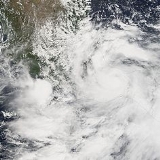
before its final landfall. This intensification did take place within 12 hours before the hurricane moved onshore. Overnight, the structure of Stan rapidly improved, with a banding eye-feature
developing within unusually deep convection with cloud-top temperatures measured at -90 C by infrared
satellites. Following this development, National Hurricane Center upgraded the storm to a Category 1 hurricane on the Saffir–Simpson Hurricane Scale. Around 1200 UTC on October 4, Stan made landfall near Punta Roca Partida, with winds of 80 mph (130 km/h). The storm also attained its lowest barometric pressure of 977 mbar (hPa; 28.85 inHg)at this time. Not long after moving over the mountainous terrain of central Mexico, Stan rapidly weakened to a tropical depression and fully dissipated early on October 5 over the state of Oaxaca
.
region on the Gulf Coast were evacuated from their homes, and incidents of mild flooding as well as wind damage (such as uprooted trees and roofs ripped off houses) were reported from coastal areas of Veracruz
, including the port of Veracruz
, Boca del Río
, San Andrés Tuxtla
, Santiago Tuxtla
, Minatitlán
and Coatzacoalcos
, as well as state capital Xalapa
further inland. The armed forces evacuated the inhabitants of a dozen or so towns on the coastal plain, between World Heritage Site
Tlacotalpan
in the west and the lakeside resort of Catemaco
in the east.
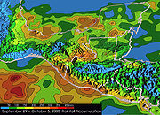
Around the time of Stan's existence, torrential rainstorms dropped upwards of 20 inches (500 mm) of rain, causing severe flash floods, mud slides, and crop damage (particularly to the coffee
crop which was close to harvest) over portions of Mexico and Central America, including Guatemala
, El Salvador
, Nicaragua
, Honduras
, and Costa Rica
. Most of the rainstorms were non-tropical in nature and impossible to relate to the hurricane; however, the impact of the larger weather system can be considered as a whole.
Hundreds more have been reported missing and are feared dead throughout the region. One estimate has the death toll above 2,000 in Guatemala
alone. The final death toll will likely never be known due to the extensive decomposition of bodies in the mud
. Note that only 80-100 of the deaths were estimated to have been as a result of Stan; the rest were not caused by Stan itself but were the result of the large system of non-tropical rains that had spawned the hurricane.
Most of the reported fatalities at this point have been as a result of the flooding and mudslides, although eight of the deaths in Nicaragua
were as a result of a boat carrying migrants from Ecuador
and Peru
that ran ashore. A large portion of the figure comes from one village alone, as a mudslide completely destroyed the village of Panabaj
in Guatemala's Sololá department.
. Flash flooding took place in several areas; however, no loss of life was reported.
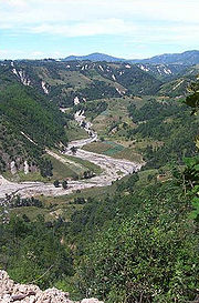
 As the system progressed inland towards the Sierra Madre del Sur
to the west of the Isthmus of Tehuantepec
, the states of Oaxaca
and Chiapas
were affected with torrential rains. Areas of Chiapas near the Guatemala
n border were hit hard, particularly the coastal border town of Tapachula
. In Tapachula the river overflowed its banks and caused tremendous damage (including the destruction of all the bridges leading in and out of the town), meaning that it was only accessible through the air. The state government reports that 33 rivers have broken their banks and that an indeterminate number of homes, upwards of 20 bridges, and other infrastructure have been smashed in the storm's wake.
Some areas in the Sierra Norte
, in the central state of Puebla
, are also flooded. Three people died in a mudslide at Xochiapulco Hill.
In addition, Pemex
had evacuated 270 employees from its oil platforms in the Gulf of Mexico, although no damage has been reported and the plants have been restarted.
The Ministry of the Interior has declared states of emergency in the worst hit municipalities of five states: Chiapas
, Hidalgo, Oaxaca
, Puebla
, and Veracruz
. According to Mexican president Vicente Fox, Hurricane Stan wrought roughly 20 billion pesos ($1.9 billion USD) in damage throughout the country.
 On October 11, 2005 at least 1,500 people were confirmed to have died, and up to 3000 were believed missing. Many communities were overwhelmed, and the worst single incident appears to have occurred in Panabaj
, an impoverished Maya
village in the highlands near Lake Atitlán in Sololá department. This volcanic lake was so overwhelmed by the torential rains that many of the small, mayan villages covering the shores experienced landslides from above. Some of the towns were so overwhelmed by the slides that the mayor has declared them graveyards, and all people who are missing are counted as dead. Piedra Grande, a hamlet
in the municipality of San Pedro Sacatepéquez
, was also destroyed. Floods and mudslides have obliterated the community of about 1,400 people, and it is feared that most or all of the population of the community lost their lives. The government has stated that they do not know what is going on in the southwest of the country, and particularly in the San Marcos department because a vital bridge
was destroyed at El Palmar, Quetzaltenango
, cutting the region off from the rest of the country. There were reported petrol shortages, including in Quetzaltenango
.
, located near the capital San Salvador
, on October 1, 2005 compounded the problems, which led to even more destructive floods and mudslides from Stan.
A state of emergency
was declared. According to the director of El Salvador's National Emergency Centre, 300 communities were affected by the floods, with over 54,000 people forced to flee their homes. A state of emergency has also been called for in Guatemala
by President
Óscar Berger
where 36,559 people were reported in emergency shelters. Some looting
has also been reported, a scene reminiscent of Hurricane Katrina
five weeks previous.
A spokesman for the Salvadoran Red Cross said that "the emergency is bigger than the rescue capacity, we have floods everywhere, bridges about to collapse, landslides and dozens of roads blocked by mudslides". The Pan-American Highway
has been cut off by mudslides leading into the capital, San Salvador
, as well as several other roads. 72 deaths have been confirmed in El Salvador.
retired the name Stan from the circulating list of Atlantic hurricane names. For the 2011 season, Stan was replaced by Sean
.
Tropical cyclone
A tropical cyclone is a storm system characterized by a large low-pressure center and numerous thunderstorms that produce strong winds and heavy rain. Tropical cyclones strengthen when water evaporated from the ocean is released as the saturated air rises, resulting in condensation of water vapor...
and eleventh hurricane
Tropical cyclone
A tropical cyclone is a storm system characterized by a large low-pressure center and numerous thunderstorms that produce strong winds and heavy rain. Tropical cyclones strengthen when water evaporated from the ocean is released as the saturated air rises, resulting in condensation of water vapor...
of the 2005 Atlantic hurricane season
2005 Atlantic hurricane season
The 2005 Atlantic hurricane season was the most active Atlantic hurricane season in recorded history, repeatedly shattering numerous records. The impact of the season was widespread and ruinous with an estimated 3,913 deaths and record damage of about $159.2 billion...
. It was also the sixth of seven tropical cyclones (three hurricanes, two of them major, three tropical storms and one tropical depression) to make landfall in Mexico. Stan was a relatively weak storm that only briefly reached hurricane
Saffir-Simpson Hurricane Scale
The Saffir–Simpson Hurricane Scale , or the Saffir–Simpson Hurricane Wind Scale , classifies hurricanes — Western Hemisphere tropical cyclones that exceed the intensities of tropical depressions and tropical storms — into five categories distinguished by the intensities of their sustained winds...
status. It was embedded in a larger non-tropical system of rainstorms that dropped torrential rains in the Central American countries of Guatemala
Guatemala
Guatemala is a country in Central America bordered by Mexico to the north and west, the Pacific Ocean to the southwest, Belize to the northeast, the Caribbean to the east, and Honduras and El Salvador to the southeast...
and El Salvador
El Salvador
El Salvador or simply Salvador is the smallest and the most densely populated country in Central America. The country's capital city and largest city is San Salvador; Santa Ana and San Miguel are also important cultural and commercial centers in the country and in all of Central America...
and in southern Mexico, causing flooding and mudslides that led to 1,628 fatalities. Throughout the affected countries, the storm left roughly $3.9 billion in damage.
Meteorological history
Hurricane Stan originated from a tropical waveTropical wave
Tropical waves, easterly waves, or tropical easterly waves, also known as African easterly waves in the Atlantic region, are a type of atmospheric trough, an elongated area of relatively low air pressure, oriented north to south, which move from east to west across the tropics causing areas of...
that was first identified by the National Hurricane Center
National Hurricane Center
The National Hurricane Center , located at Florida International University in Miami, Florida, is the division of the National Weather Service responsible for tracking and predicting weather systems within the tropics between the Prime Meridian and the 140th meridian west poleward to the 30th...
(NHC) off the west coast of Africa on September 17, 2005. Traveling westward, the wave remained weak, barely being notable. By September 22, before convection
Atmospheric convection
Atmospheric convection is the result of a parcel-environment instability, or temperature difference, layer in the atmosphere. Different lapse rates within dry and moist air lead to instability. Mixing of air during the day which expands the height of the planetary boundary layer leads to...
began to increase; however, wind shear
Wind shear
Wind shear, sometimes referred to as windshear or wind gradient, is a difference in wind speed and direction over a relatively short distance in the atmosphere...
in the region prevented this development from lasting. The system entered the Caribbean Sea
Caribbean Sea
The Caribbean Sea is a sea of the Atlantic Ocean located in the tropics of the Western hemisphere. It is bounded by Mexico and Central America to the west and southwest, to the north by the Greater Antilles, and to the east by the Lesser Antilles....
several days later, a region with more favorable conditions for cyclonic development. Intermittent convection formed around the wave as it moved west-northwestward before the development maintained itself. On October 1, the system had become sufficiently organized for the NHC to classify it as Tropical Depression Twenty, with the center of circulation situated roughly 135 mi (215 km) souhteast of Cozumel
Cozumel
Cozumel is an island in the Caribbean Sea off the eastern coast of Mexico's Yucatan Peninsula, opposite Playa del Carmen, and close to the Yucatan Channel. Cozumel is one of the ten municipalities of the state of Quintana Roo...
, Mexico
Mexico
The United Mexican States , commonly known as Mexico , is a federal constitutional republic in North America. It is bordered on the north by the United States; on the south and west by the Pacific Ocean; on the southeast by Guatemala, Belize, and the Caribbean Sea; and on the east by the Gulf of...
.
Located to the south of a low to mid-level tropospheric
Troposphere
The troposphere is the lowest portion of Earth's atmosphere. It contains approximately 80% of the atmosphere's mass and 99% of its water vapor and aerosols....
ridge
Ridge (meteorology)
A ridge is an elongated region of relatively high atmospheric pressure, the opposite of a trough....
, the depression tracked towards the west-northwest. Within a few hours of being warned upon, the system further intensified into Tropical Storm Stan. This followed the development of a strong convective banding feature
Rainband
A rainband is a cloud and precipitation structure associated with an area of rainfall which is significantly elongated. Rainbands can be stratiform or convective, and are generated by differences in temperature. When noted on weather radar imagery, this precipitation elongation is referred to as...
to the southeast of the storm's center. Around 1000 UTC
Coordinated Universal Time
Coordinated Universal Time is the primary time standard by which the world regulates clocks and time. It is one of several closely related successors to Greenwich Mean Time. Computer servers, online services and other entities that rely on having a universally accepted time use UTC for that purpose...
(5 a.m. CDT) on October 2, Stan made its first landfall near Punta Hualaxtoc, Mexico, roughly 35 mi (55 km) south of Tulum, with winds of 40 mph (65 km/h). Over the following 18 hours, the weak storm traversed the southern portion of the Yucatán Peninsula
Yucatán Peninsula
The Yucatán Peninsula, in southeastern Mexico, separates the Caribbean Sea from the Gulf of Mexico, with the northern coastline on the Yucatán Channel...
. Upon entering the Gulf of Mexico
Gulf of Mexico
The Gulf of Mexico is a partially landlocked ocean basin largely surrounded by the North American continent and the island of Cuba. It is bounded on the northeast, north and northwest by the Gulf Coast of the United States, on the southwest and south by Mexico, and on the southeast by Cuba. In...
on October 3, Stan had weakened to a tropical depression; however, convection began to redevelop over the storm's center, allowing the system to re-attain tropical storm status.
Bay of Campeche
The Bay of Campeche is the southern bight of the Gulf of Mexico. It is surrounded on three sides by the Mexican states of Campeche, Tabasco and Veracruz. It was named by Francisco Hernández de Córdoba and Antonio de Alaminos during their expedition in 1517...
. Late on October 3, forecasters at National Hurricane Center noted a statistical rapid intensity index indicating a 49% chance of Stan undergoing rapid intensification
Rapid deepening
Rapid deepening, also known as rapid intensification, is a meteorological condition that occurs when the minimum sea-level atmospheric pressure of a tropical cyclone decreases drastically in a short period of time. The National Weather Service describes rapid deepening as a decrease of...
before its final landfall. This intensification did take place within 12 hours before the hurricane moved onshore. Overnight, the structure of Stan rapidly improved, with a banding eye-feature
Eye (cyclone)
The eye is a region of mostly calm weather found at the center of strong tropical cyclones. The eye of a storm is a roughly circular area and typically 30–65 km in diameter. It is surrounded by the eyewall, a ring of towering thunderstorms where the second most severe weather of a cyclone...
developing within unusually deep convection with cloud-top temperatures measured at -90 C by infrared
Infrared
Infrared light is electromagnetic radiation with a wavelength longer than that of visible light, measured from the nominal edge of visible red light at 0.74 micrometres , and extending conventionally to 300 µm...
satellites. Following this development, National Hurricane Center upgraded the storm to a Category 1 hurricane on the Saffir–Simpson Hurricane Scale. Around 1200 UTC on October 4, Stan made landfall near Punta Roca Partida, with winds of 80 mph (130 km/h). The storm also attained its lowest barometric pressure of 977 mbar (hPa; 28.85 inHg)at this time. Not long after moving over the mountainous terrain of central Mexico, Stan rapidly weakened to a tropical depression and fully dissipated early on October 5 over the state of Oaxaca
Oaxaca
Oaxaca , , officially Estado Libre y Soberano de Oaxaca is one of the 31 states which, along with the Federal District, comprise the 32 federative entities of Mexico. It is divided into 571 municipalities; of which 418 are governed by the system of customs and traditions...
.
Preparations
Some 100,000 inhabitants of the Sierra de los TuxtlasSierra de los Tuxtlas
The Sierra de Los Tuxtlas are a volcanic belt and mountain range along the southeastern Veracruz Gulf coast in southcentral Mexico....
region on the Gulf Coast were evacuated from their homes, and incidents of mild flooding as well as wind damage (such as uprooted trees and roofs ripped off houses) were reported from coastal areas of Veracruz
Veracruz
Veracruz, formally Veracruz de Ignacio de la Llave officially Estado Libre y Soberano de Veracruz de Ignacio de la Llave , is one of the 31 states that, along with the Federal District, comprise the 32 federative entities of Mexico. It is divided in 212 municipalities and its capital city is...
, including the port of Veracruz
Veracruz, Veracruz
Veracruz, officially known as Heroica Veracruz, is a major port city and municipality on the Gulf of Mexico in the Mexican state of Veracruz. The city is located in the central part of the state. It is located along Federal Highway 140 from the state capital Xalapa, and is the state's most...
, Boca del Río
Boca del Río, Veracruz
Boca del Río is a city and municipality located in the center of the state of Veracruz. The small city of Boca del Río serves as the seat of the municipality. The municipality lies just south of Veracruz Municipality, and contains a part of the city and port of Veracruz, Mexico...
, San Andrés Tuxtla
San Andrés Tuxtla
The municipio of San Andrés Tuxtla is located in the south-central portion of the Mexican state of Veracruz. Its municipal seat is also called San Andrés Tuxtla, located 150 km from the city of Veracruz along Federal Highway 180 in the Sierra de Los Tuxtlas region.The municipality which...
, Santiago Tuxtla
Santiago Tuxtla
The municipality of Santiago Tuxtla, in the Mexican state of Veracruz, was founded in 1524.The municipality has approximately 51,000 inhabitants and occupies the northwestern slope of Volcano San Martin to the Rio San Juan...
, Minatitlán
Minatitlán, Veracruz
Minatitlán is a city in southeastern Mexican state of Veracruz in the Olmec region of the state and the north of the Isthmus of Tehuantepec.In 2010 the greater metropolitan area had a population of 356,020...
and Coatzacoalcos
Coatzacoalcos
Coatzacoalcos is a major port city in the southern part of the Mexican state of Veracruz, on the Coatzacoalcos River. Coatzacoalcos comes from an indigenous word meaning "Site of the Snake" or "Where the snake hides"...
, as well as state capital Xalapa
Xalapa
Xalapa-Enríquez, commonly Xalapa or Jalapa, is the capital city of the Mexican state of Veracruz and the name of the surrounding municipality. In the year 2005 census the city reported a population of 387,879 and the municipality of which it serves as municipal seat reported a population of...
further inland. The armed forces evacuated the inhabitants of a dozen or so towns on the coastal plain, between World Heritage Site
World Heritage Site
A UNESCO World Heritage Site is a place that is listed by the UNESCO as of special cultural or physical significance...
Tlacotalpan
Tlacotalpan
The city of Tlacotalpan is located in the eastern coastal region of the Mexican state of Veracruz. Although the area had been inhabited since pre-Columbian times, the modern-day settlement was founded as a river port on the banks of the Río Papaloapan in the mid-16th century...
in the west and the lakeside resort of Catemaco
Catemaco
Catemaco is a municipality and city in the southeast of Mexican state of Veracruz, in the Sierra de Los Tuxtlas volcanic mountain range, along the Gulf of Mexico...
in the east.
Impact
| Country | Fatalities | Damage (USD) |
| Costa Rica Costa Rica Costa Rica , officially the Republic of Costa Rica is a multilingual, multiethnic and multicultural country in Central America, bordered by Nicaragua to the north, Panama to the southeast, the Pacific Ocean to the west and the Caribbean Sea to the east.... |
1 | $20 million |
| El Salvador El Salvador El Salvador or simply Salvador is the smallest and the most densely populated country in Central America. The country's capital city and largest city is San Salvador; Santa Ana and San Miguel are also important cultural and commercial centers in the country and in all of Central America... |
69 | $355.7 million |
| Guatemala Guatemala Guatemala is a country in Central America bordered by Mexico to the north and west, the Pacific Ocean to the southwest, Belize to the northeast, the Caribbean to the east, and Honduras and El Salvador to the southeast... |
1,513 | $988.3 million |
| Honduras Honduras Honduras is a republic in Central America. It was previously known as Spanish Honduras to differentiate it from British Honduras, which became the modern-day state of Belize... |
6 | $100 million |
| Mexico Mexico The United Mexican States , commonly known as Mexico , is a federal constitutional republic in North America. It is bordered on the north by the United States; on the south and west by the Pacific Ocean; on the southeast by Guatemala, Belize, and the Caribbean Sea; and on the east by the Gulf of... |
36 | $2.5 billion |
| Nicaragua Nicaragua Nicaragua is the largest country in the Central American American isthmus, bordered by Honduras to the north and Costa Rica to the south. The country is situated between 11 and 14 degrees north of the Equator in the Northern Hemisphere, which places it entirely within the tropics. The Pacific Ocean... |
3 | Unknown |
| Total | 1,628 | $3.964 billion |
Around the time of Stan's existence, torrential rainstorms dropped upwards of 20 inches (500 mm) of rain, causing severe flash floods, mud slides, and crop damage (particularly to the coffee
Coffee
Coffee is a brewed beverage with a dark,init brooo acidic flavor prepared from the roasted seeds of the coffee plant, colloquially called coffee beans. The beans are found in coffee cherries, which grow on trees cultivated in over 70 countries, primarily in equatorial Latin America, Southeast Asia,...
crop which was close to harvest) over portions of Mexico and Central America, including Guatemala
Guatemala
Guatemala is a country in Central America bordered by Mexico to the north and west, the Pacific Ocean to the southwest, Belize to the northeast, the Caribbean to the east, and Honduras and El Salvador to the southeast...
, El Salvador
El Salvador
El Salvador or simply Salvador is the smallest and the most densely populated country in Central America. The country's capital city and largest city is San Salvador; Santa Ana and San Miguel are also important cultural and commercial centers in the country and in all of Central America...
, Nicaragua
Nicaragua
Nicaragua is the largest country in the Central American American isthmus, bordered by Honduras to the north and Costa Rica to the south. The country is situated between 11 and 14 degrees north of the Equator in the Northern Hemisphere, which places it entirely within the tropics. The Pacific Ocean...
, Honduras
Honduras
Honduras is a republic in Central America. It was previously known as Spanish Honduras to differentiate it from British Honduras, which became the modern-day state of Belize...
, and Costa Rica
Costa Rica
Costa Rica , officially the Republic of Costa Rica is a multilingual, multiethnic and multicultural country in Central America, bordered by Nicaragua to the north, Panama to the southeast, the Pacific Ocean to the west and the Caribbean Sea to the east....
. Most of the rainstorms were non-tropical in nature and impossible to relate to the hurricane; however, the impact of the larger weather system can be considered as a whole.
Hundreds more have been reported missing and are feared dead throughout the region. One estimate has the death toll above 2,000 in Guatemala
Guatemala
Guatemala is a country in Central America bordered by Mexico to the north and west, the Pacific Ocean to the southwest, Belize to the northeast, the Caribbean to the east, and Honduras and El Salvador to the southeast...
alone. The final death toll will likely never be known due to the extensive decomposition of bodies in the mud
Mud
Mud is a mixture of water and some combination of soil, silt, and clay. Ancient mud deposits harden over geological time to form sedimentary rock such as shale or mudstone . When geological deposits of mud are formed in estuaries the resultant layers are termed bay muds...
. Note that only 80-100 of the deaths were estimated to have been as a result of Stan; the rest were not caused by Stan itself but were the result of the large system of non-tropical rains that had spawned the hurricane.
Most of the reported fatalities at this point have been as a result of the flooding and mudslides, although eight of the deaths in Nicaragua
Nicaragua
Nicaragua is the largest country in the Central American American isthmus, bordered by Honduras to the north and Costa Rica to the south. The country is situated between 11 and 14 degrees north of the Equator in the Northern Hemisphere, which places it entirely within the tropics. The Pacific Ocean...
were as a result of a boat carrying migrants from Ecuador
Ecuador
Ecuador , officially the Republic of Ecuador is a representative democratic republic in South America, bordered by Colombia on the north, Peru on the east and south, and by the Pacific Ocean to the west. It is one of only two countries in South America, along with Chile, that do not have a border...
and Peru
Peru
Peru , officially the Republic of Peru , is a country in western South America. It is bordered on the north by Ecuador and Colombia, on the east by Brazil, on the southeast by Bolivia, on the south by Chile, and on the west by the Pacific Ocean....
that ran ashore. A large portion of the figure comes from one village alone, as a mudslide completely destroyed the village of Panabaj
Panabaj
Panabaj, located on the edge of Lake Atitlán in the western highlands of Guatemala, is a small village within the municipality of Santiago Atitlán, bordering the city of Santiago Atitlán proper, in the department of Sololá...
in Guatemala's Sololá department.
Mexico
As a tropical storm, Stan brought torrential rainfall and gusty winds to parts of the Yucatan PeninsulaYucatán Peninsula
The Yucatán Peninsula, in southeastern Mexico, separates the Caribbean Sea from the Gulf of Mexico, with the northern coastline on the Yucatán Channel...
. Flash flooding took place in several areas; however, no loss of life was reported.
Sierra Madre del Sur
The Sierra Madre del Sur is a mountain range in southern Mexico, extending from southern Michoacán east through Guerrero, to the Istmo de Tehuantepec in eastern Oaxaca.-Geography:...
to the west of the Isthmus of Tehuantepec
Isthmus of Tehuantepec
The Isthmus of Tehuantepec is an isthmus in Mexico. It represents the shortest distance between the Gulf of Mexico and the Pacific Ocean, and prior to the opening of the Panama Canal was a major shipping route known simply as the Tehuantepec Route...
, the states of Oaxaca
Oaxaca
Oaxaca , , officially Estado Libre y Soberano de Oaxaca is one of the 31 states which, along with the Federal District, comprise the 32 federative entities of Mexico. It is divided into 571 municipalities; of which 418 are governed by the system of customs and traditions...
and Chiapas
Chiapas
Chiapas officially Estado Libre y Soberano de Chiapas is one of the 31 states that, with the Federal District, comprise the 32 Federal Entities of Mexico. It is divided in 118 municipalities and its capital city is Tuxtla Gutierrez. Other important cites in Chiapas include San Cristóbal de las...
were affected with torrential rains. Areas of Chiapas near the Guatemala
Guatemala
Guatemala is a country in Central America bordered by Mexico to the north and west, the Pacific Ocean to the southwest, Belize to the northeast, the Caribbean to the east, and Honduras and El Salvador to the southeast...
n border were hit hard, particularly the coastal border town of Tapachula
Tapachula
Tapachula is a town and with a hot, humid climate in the Mexican state of Chiapas. It is located in southern part of the state on the Soconusco coastal plain, near the border with Guatemala, at 14.91° N 92.27° W...
. In Tapachula the river overflowed its banks and caused tremendous damage (including the destruction of all the bridges leading in and out of the town), meaning that it was only accessible through the air. The state government reports that 33 rivers have broken their banks and that an indeterminate number of homes, upwards of 20 bridges, and other infrastructure have been smashed in the storm's wake.
Some areas in the Sierra Norte
Sierra Norte de Puebla
The Sierra Norte de Puebla – known simply as the Sierra Norte by locals – is a mountain range that makes up the southern end of the Sierra Madre Oriental in central Mexico.-Mountain range:...
, in the central state of Puebla
Puebla
Puebla officially Estado Libre y Soberano de Puebla is one of the 31 states which, with the Federal District, comprise the 32 Federal Entities of Mexico. It is divided in 217 municipalities and its capital city is Puebla....
, are also flooded. Three people died in a mudslide at Xochiapulco Hill.
In addition, Pemex
Pemex
Petróleos Mexicanos or Pemex is a Mexican state-owned petroleum company. As of 2010, with a total asset worth of $415.75 billion, it is the second non-publicly listed largest company in the world by total market value, and Latin America's second largest enterprise by annual revenue as of 2009...
had evacuated 270 employees from its oil platforms in the Gulf of Mexico, although no damage has been reported and the plants have been restarted.
The Ministry of the Interior has declared states of emergency in the worst hit municipalities of five states: Chiapas
Chiapas
Chiapas officially Estado Libre y Soberano de Chiapas is one of the 31 states that, with the Federal District, comprise the 32 Federal Entities of Mexico. It is divided in 118 municipalities and its capital city is Tuxtla Gutierrez. Other important cites in Chiapas include San Cristóbal de las...
, Hidalgo, Oaxaca
Oaxaca
Oaxaca , , officially Estado Libre y Soberano de Oaxaca is one of the 31 states which, along with the Federal District, comprise the 32 federative entities of Mexico. It is divided into 571 municipalities; of which 418 are governed by the system of customs and traditions...
, Puebla
Puebla
Puebla officially Estado Libre y Soberano de Puebla is one of the 31 states which, with the Federal District, comprise the 32 Federal Entities of Mexico. It is divided in 217 municipalities and its capital city is Puebla....
, and Veracruz
Veracruz
Veracruz, formally Veracruz de Ignacio de la Llave officially Estado Libre y Soberano de Veracruz de Ignacio de la Llave , is one of the 31 states that, along with the Federal District, comprise the 32 federative entities of Mexico. It is divided in 212 municipalities and its capital city is...
. According to Mexican president Vicente Fox, Hurricane Stan wrought roughly 20 billion pesos ($1.9 billion USD) in damage throughout the country.
Honduras
Throughout Honduras, heavy rains produced by Hurricane Stan resulted in six fatalities and roughly $100 million in losses.Guatemala
Panabaj
Panabaj, located on the edge of Lake Atitlán in the western highlands of Guatemala, is a small village within the municipality of Santiago Atitlán, bordering the city of Santiago Atitlán proper, in the department of Sololá...
, an impoverished Maya
Maya peoples
The Maya people constitute a diverse range of the Native American people of southern Mexico and northern Central America. The overarching term "Maya" is a collective designation to include the peoples of the region who share some degree of cultural and linguistic heritage; however, the term...
village in the highlands near Lake Atitlán in Sololá department. This volcanic lake was so overwhelmed by the torential rains that many of the small, mayan villages covering the shores experienced landslides from above. Some of the towns were so overwhelmed by the slides that the mayor has declared them graveyards, and all people who are missing are counted as dead. Piedra Grande, a hamlet
Hamlet (place)
A hamlet is usually a rural settlement which is too small to be considered a village, though sometimes the word is used for a different sort of community. Historically, when a hamlet became large enough to justify building a church, it was then classified as a village...
in the municipality of San Pedro Sacatepéquez
San Pedro Sacatepéquez
San Pedro Sacatepéquez is the name of two locations in Guatemala:*In Guatemala department:**San Pedro Sacatepéquez, Guatemala*In San Marcos department:**San Pedro Sacatepéquez, San Marcos...
, was also destroyed. Floods and mudslides have obliterated the community of about 1,400 people, and it is feared that most or all of the population of the community lost their lives. The government has stated that they do not know what is going on in the southwest of the country, and particularly in the San Marcos department because a vital bridge
Bridge
A bridge is a structure built to span physical obstacles such as a body of water, valley, or road, for the purpose of providing passage over the obstacle...
was destroyed at El Palmar, Quetzaltenango
El Palmar, Quetzaltenango
El Palmar is a municipality in the Quetzaltenango department of GuatemalaEl Palmar is mostly an agricultural municipality, with coffee being one of its main products....
, cutting the region off from the rest of the country. There were reported petrol shortages, including in Quetzaltenango
Quetzaltenango
Quetzaltenango, also commonly known by its indigenous name, Xelajú , or more commonly, Xela , is the second largest city of Guatemala. It is both the capital of Quetzaltenango Department and the municipal seat of Quetzaltenango municipality....
.
El Salvador
The eruption of the Santa Ana volcanoSanta Ana Volcano
The Santa Ana Volcano or Ilamatepec is a large stratovolcano located in the Santa Ana department of El Salvador. At 2,381 metres above sea level, it is the highest volcano in the country. It is located immediately west of Coatepeque Caldera....
, located near the capital San Salvador
San Salvador
The city of San Salvador the capital and largest city of El Salvador, which has been designated a Gamma World City. Its complete name is La Ciudad de Gran San Salvador...
, on October 1, 2005 compounded the problems, which led to even more destructive floods and mudslides from Stan.
A state of emergency
State of emergency
A state of emergency is a governmental declaration that may suspend some normal functions of the executive, legislative and judicial powers, alert citizens to change their normal behaviours, or order government agencies to implement emergency preparedness plans. It can also be used as a rationale...
was declared. According to the director of El Salvador's National Emergency Centre, 300 communities were affected by the floods, with over 54,000 people forced to flee their homes. A state of emergency has also been called for in Guatemala
Guatemala
Guatemala is a country in Central America bordered by Mexico to the north and west, the Pacific Ocean to the southwest, Belize to the northeast, the Caribbean to the east, and Honduras and El Salvador to the southeast...
by President
President of Guatemala
The title of President of Guatemala has been the usual title of the leader of Guatemala since 1839, when that title was assumed by Mariano Rivera Paz...
Óscar Berger
Óscar Berger
Óscar José Rafael Berger Perdomo, born on 11 August 1946 in Guatemala City, is a former President of Guatemala.-Early years:Of Belgian descent, Berger was born to an upper class family with large sugar and coffee holdings...
where 36,559 people were reported in emergency shelters. Some looting
Looting
Looting —also referred to as sacking, plundering, despoiling, despoliation, and pillaging—is the indiscriminate taking of goods by force as part of a military or political victory, or during a catastrophe, such as during war, natural disaster, or rioting...
has also been reported, a scene reminiscent of Hurricane Katrina
Hurricane Katrina
Hurricane Katrina of the 2005 Atlantic hurricane season was a powerful Atlantic hurricane. It is the costliest natural disaster, as well as one of the five deadliest hurricanes, in the history of the United States. Among recorded Atlantic hurricanes, it was the sixth strongest overall...
five weeks previous.
A spokesman for the Salvadoran Red Cross said that "the emergency is bigger than the rescue capacity, we have floods everywhere, bridges about to collapse, landslides and dozens of roads blocked by mudslides". The Pan-American Highway
Pan-American Highway
The Pan-American Highway is a network of roads measuring about in total length. Except for an rainforest break, called the Darién Gap, the road links the mainland nations of the Americas in a connected highway system. According to Guinness World Records, the Pan-American Highway is the world's...
has been cut off by mudslides leading into the capital, San Salvador
San Salvador
The city of San Salvador the capital and largest city of El Salvador, which has been designated a Gamma World City. Its complete name is La Ciudad de Gran San Salvador...
, as well as several other roads. 72 deaths have been confirmed in El Salvador.
Retirement
Following the severe damage and extensive loss of life in Stan's wake, the World Meteorological OrganizationWorld Meteorological Organization
The World Meteorological Organization is an intergovernmental organization with a membership of 189 Member States and Territories. It originated from the International Meteorological Organization , which was founded in 1873...
retired the name Stan from the circulating list of Atlantic hurricane names. For the 2011 season, Stan was replaced by Sean
Tropical Storm Sean (2011)
Tropical Storm Sean was a tropical cyclone that affected the island of Bermuda in November of the 2011 Atlantic hurricane season. The nineteenth tropical system and the eighteenth named storm of the 2011 season, Sean developed from a non-tropical low pressure area on November 8. Initially...
.
See also
- List of tropical cyclones
- List of Atlantic hurricanes
- List of 2005 Atlantic hurricane season storms
- Hurricane MitchHurricane MitchHurricane Mitch was the most powerful hurricane and the most destructive of the 1998 Atlantic hurricane season, with maximum sustained winds of 180 mph . The storm was the thirteenth tropical storm, ninth hurricane, and third major hurricane of the season. Along with Hurricane Georges, Mitch...
- Timeline of the 2005 Atlantic hurricane seasonTimeline of the 2005 Atlantic hurricane seasonThe timeline of the 2005 Atlantic hurricane season documents the formations, strengthenings, weakenings, landfalls, extratropical transitions, and dissipations of the season's tropical and subtropical storms. The 2005 Atlantic hurricane season was the most active Atlantic hurricane season in...
External links
- NHC's archive of Hurricane Stan
- NHC's Tropical Weather Summary through November 2005
- NCDC's Atlantic hurricane season 2005 summary
- Cordinadora Para La Reduccion De Desastres En Guatemala (Conred) Guatemala's Disaster Reduction Institute(in Spanish).
- USAID (US government) information on hurricane/flood relief and recovery efforts
- Al Jazeera: Hundreds die in Guatemala mudslide
- BBC: Guatemala storm deaths increase