
2008 Atlantic hurricane season
Encyclopedia
The 2008 Atlantic hurricane season was a very active hurricane season
with sixteen named storms formed, including eight that became hurricanes and five that became major hurricanes. The season officially started on June 1 and ended on November 30. These dates conventionally delimit the period of each year when most tropical cyclones form in the Atlantic basin
. However, the formation of Tropical Storm Arthur
caused the season to start two days early. This season is the third most costly on record, behind only the 2004
and 2005
seasons, with over $47.5 billion in damage (2008 USD
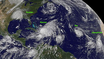
). It was the fourth busiest year since 1944 and the only year on record in which a major hurricane existed in every month from July through November in the North Atlantic. Bertha became the longest lived July tropical cyclone on record for the basin, the first of several long-lived systems during 2008. The season was devastating for Haiti
, where over 800 people were killed by four consecutive tropical cyclones (Fay, Gustav, Hanna, and Ike), especially Hanna, in August and September. Ike was also the most destructive storm of the season, as well as the strongest, devastating Cuba
as a major hurricane and later making landfall near Galveston, Texas
at Category 2 (nearly Category 3) intensity.
One very unusual feat was a streak of tropical cyclones affecting land, starting with the first storm of the season, Arthur, and then every single storm that formed affected land in some way as a tropical cyclone, whether it'd be landfall, or outer effects such as rain and waves with Cristobal, until Tropical Storm Laura in late September. The unprecedented number of storms with impact led to one of the more deadlier and among the most destructive seasons in the history of the Atlantic basin, especially with Hurricane Ike, as its overall damages made it the third costliest hurricane in the Atlantic.
Forecasts of hurricane activity
are issued before each hurricane season by noted hurricane experts Dr. Philip J. Klotzbach, Dr. William M. Gray
, and their associates at Colorado State University
; and separately by NOAA
forecasters.
Dr. Klotzbach's team (formerly led by Dr. Gray) defined the average number of storms per season (1950 to 2000) as 9.6 tropical storms, 5.9 hurricanes, and 2.3 major hurricanes (storms reaching at least Category 3 strength in the Saffir-Simpson Hurricane Scale
). A normal season, as defined by NOAA, has 9 to 12 named storms, with 5 to 7 of those reaching hurricane strength, and 1 to 3 major hurricanes.
issued a new forecast, anticipating a well above average hurricane season of 15 named storms, 8 hurricanes, and 4 intense hurricanes. The National Oceanic and Atmospheric Administration
(NOAA) predicted an above average season with 12 to 16 storms, 6 to 9 hurricanes, and 2 to 5 major hurricanes on May 22.
(UKMO) issued a forecast of 15 tropical storms in the July to November period with a 70% chance that the number would be in the range 10 to 20. However, actual predictions of the number of tropical storms, hurricanes, and major hurricanes were not given. On August 5, following the intense start, the CSU called for 17 storms, 9 hurricanes, and 5 major hurricanes, slightly higher than their prior forecast of 15 storms. On August 7, in response to the season's strong start, NOAA reaffirmed its pre-season outlook of above-average activity. The organization increased its expected probability of such a season to 85% from 65% in its May forecast.
The 2008 hurricane season saw the first occurrence of major hurricanes in the months of July through November. Four storms formed before the start of August, and the season also had the earliest known date for three storms to be active on the same day: Hurricane Bertha
, and Tropical Storms Cristobal
and Dolly
were all active on July 20. This season was also one of only nine Atlantic seasons on record to have a major hurricane form before August. This is also the first year four or more Category 4 storms have formed in a single year since 2005, which had 5, and was one of only 7 Atlantic seasons to feature a major hurricane in November.
The season was devastating for Haiti
, where over 800 people were killed by four consecutive tropical cyclones (Fay, Gustav, Hanna, and Ike) in August and September. Hurricane Ike
was the most destructive storm of the season, as well as the strongest, devastating Cuba
as a major hurricane and later making landfall near Galveston, Texas
at Category 2 (nearly Category 3) intensity. It caused a particularly devastating storm surge along the western Gulf Coast of the United States
due to in part to its large size. Hurricane Hanna
was the deadliest storm of the season, killing 537 people, mostly in Haiti. Hurricane Gustav
was another very destructive storm, causing up to $6.61 billion in damage to Haiti
, Jamaica
, the Cayman Islands
, Cuba
, and the U.S.
Hurricane Dolly
caused up to $1.35 billion in damage to south Texas and northeastern Mexico. Hurricane Bertha
was an early season Cape Verde-type hurricane
that became the longest lived pre-August North Atlantic tropical cyclone on record, though it caused few deaths and only minor damage.
Other notable storms in the year included Tropical Storm Arthur
, which marked the first recorded time the Atlantic saw a named storm form in May in consecutive years, Tropical Storm Fay
, which became the first Atlantic tropical cyclone to make landfall in the same U.S. state on 4 separate occasions; Tropical Storm Marco
, the smallest Atlantic tropical cyclone recorded since 1988, Hurricane Omar
, a powerful late-season major hurricane which caused moderate damage to the ABC islands, Puerto Rico
, and the Virgin Islands
in mid-October; and Hurricane Paloma, which became the second strongest November hurricane in recorded history and caused about $900 million in damage to the Cayman Islands
and Cuba
. The only storm of the season to not reach tropical storm status, Tropical Depression Sixteen
, caused significant flooding in Central America which killed more than 75 people and caused at least $150 million in damages.
Overall, the season's activity was reflected with a total cumulative accumulated cyclone energy
(ACE) rating of 146. ACE is, broadly speaking, a measure of the power of the hurricane multiplied by the length of time it existed, so storms that last a long time, as well as particularly strong hurricanes, have high ACEs. ACE is only calculated for full advisories on tropical systems at or exceeding 34 knots (39 mph, 63 km/h) or tropical storm strength. Subtropical cyclone
s are excluded from the total.
coast early on May 31, developing out of the interaction between a tropical wave
and the remnants of Tropical Storm Alma
, and made landfall on Belize later that day. The system traversed the Yucatán Peninsula
slowly and dissipated inland early on June 2. When Arthur made landfall on Belize
it caused an estimated US$78 million worth of damage and killed 9 people, 5 of them directly.
Arthur is the first reported tropical storm to form in May since Tropical Storm Arlene in 1981. Other systems have formed, but were subtropical (such as Andrea
in 2007). Given Arthur's very short lifespan, Jeff Masters questions whether it would have been reported and named in the years prior to today's technology. The formation of Arthur also marks the first time that a named storm formed in May for two consecutive years.
emerged off the coast of Africa
. By early the next day, a surface low developed and the wave became better organized. The National Hurricane Center
upgraded the system to Tropical Depression Two in the morning hours of July 3 after the system was able to maintain convection
over its center for at least 12 hours. The depression organized further and developed two distinct bands of convection. Six hours after becoming a depression, it was upgraded to Tropical Storm Bertha, the second named storm of the season. The National Hurricane Center noted that this tropical cyclone was remarkably forecast up to a week in advance by many global computer models
.
After a bout of strengthening on July 6, Bertha was upgraded to a hurricane early on July 7 as satellite and microwave imagery indicated an eye
feature had formed. It continued to strengthen that morning. Rapid intensification continued that afternoon and Bertha strengthened into a major hurricane with 125 mph (205 km/h) winds and a well-defined eye. The strengthening trend abated early on July 8, due to wind shear, and Bertha rapidly weakened back to a Category 1 hurricane that afternoon.
Bertha again began to rapidly intensify on July 9 as a new eye had formed and the system became more symmetrical. The NHC upgraded Bertha to a Category 2 with winds of 105 mph (170 km/h) and stated that Bertha could intensify further to major hurricane status again, but instead weakened into an 85 mph (135 km/h) Category 1 hurricane. On July 12, Bertha slowed in movement, becoming almost stationary and by July 13 this slow movement weakened the storm to tropical storm strength. The storm brought rain and tropical storm-force winds to Bermuda
on July 14, but no damage was reported. After slowly meandering to the east and then the southeast, Bertha regained hurricane strength on the 18th as it began accelerating towards the northeast. As it moved over cooler waters, it weakened slightly to a tropical storm late on July 19. It finally became extratropical on July 20 southwest of Iceland
. Bertha is the longest-lived pre-August Atlantic tropical cyclone
on record.
formed on July 15. The system slowly developed into a Tropical Depression on July 18 while located 65 mi (104.6 km) to the south-southeast of Charleston, South Carolina
. The depression gradually became better organized and was upgraded to Tropical Storm Cristobal the next day while located 225 mi (362.1 km) to the southwest of Cape Hatteras, North Carolina. Cristobal paralleled the North Carolina
coastline for the next two days with minimal to no impact as most of the convection and wind was located on the eastern half of the storm. However, there was some heavy rainfall amounting up to 5 in (127 mm) in localized areas of southern North Carolina. On July 20, Cristobal began to move away from the coastline and began to intensify as it passed over the Gulf Stream
. Cristobal peaked the next day with winds of 65 mph (104.6 km/h). As Cristobal moved closer to Nova Scotia
, it began to lose its tropical characteristics. By July 23, Cristobal had transitioned into an extratropical cyclone.
in the third week of July. Despite producing strong convection and tropical storm-force sustained winds, it failed to develop a low-level circulation until July 20. That morning, reconnaissance aircraft found a low-level circulation and the system was declared Tropical Storm Dolly. This marked the fastest start of a hurricane season since 2005
.
It made landfall early on July 21 as a weak and disorganized tropical storm near Cancun, and emerged over the Gulf of Mexico
later that morning. 17 deaths were reported in Guatemala
from landslides caused by heavy rain on the fringes of Dolly.
On July 22 at 4 p.m. CDT, it strengthened into the second hurricane of the season. It steadily strengthened that night into the morning of July 23 and reached Category 2 intensity. Dolly then weakened some before it made landfall at 1 p.m. CDT (1800 UTC) on South Padre Island
as a Category 1 hurricane. Dolly caused no deaths in Texas; it did, however, become the most damaging hurricane to affect Texas
since 2005's Hurricane Rita
, with US$1.05 billion dollars in damage. It was also the most destructive hurricane to make landfall in Texas since 1983's Alicia
, and was the fourth costliest Texas hurricane in history, behind Hurricane Rita
, Hurricane Alicia
, and Hurricane Ike
later in the season. The remnant low caused flash flooding and two deaths in New Mexico
before dissipating late on July 27.
in early August as troughing aloft dug into the northeast Gulf of Mexico. This energy aloft helped to organize a surface low along the shearline early on August 2, which slowly organized over the following day. It strengthened into Tropical Depression Five before gaining intensity and being named Tropical Storm Edouard on August 3. The storm made landfall in Southeast Texas
near Port Arthur
on the morning of August 5 as a strong tropical storm. As it moved inland, the system weakened into a tropical depression by afternoon. The depression dissipated late on August 6 while inland over Texas
.
in mid-August. It produced heavy rain across the Leeward Islands
and into Puerto Rico
before tracking westward, while unable to develop a low-level circulation despite producing tropical storm-force winds. On August 15, a closed circulation was found and the system was declared Tropical Storm Fay. Later that day Fay produced heavy rains on the island of Hispaniola
prompting a major flash flood threat. Fay crossed Hispaniola, Cuba, and hit south Florida beginning late on August 18, slowly tracking northeastward across the peninsula. Significant flooding resulted in much of eastern Florida, along with some wind damage. After crossing into the Atlantic, Fay turned westward again and crossed northern Florida on August 22. As it zigzagged from water to land, it became the first storm in recorded history to make landfall in Florida four times. Fay weakened into a tropical depression along the north coast of the Gulf of Mexico
. Fay eventually became extratropical on the morning of August 27 while located over Tennessee
. Fay was responsible for 36 deaths and at least $560 million in damage (2008 USD).
where it encountered more favorable conditions, and became a tropical depression on the morning of August 25, west of the Windward Islands
. It rapidly intensified into Tropical Storm Gustav early that afternoon and into Hurricane Gustav early on August 26. Striking southwest Haiti
, it weakened into a tropical storm on the evening of August 27 due to land interaction and slowed down considerably. It re-organized further south into a strong tropical storm once again on August 28 before speeding up and hitting Jamaica
. Gustav killed 92 people in Haiti
, the Dominican Republic
, and Jamaica
. It then was upgraded to a hurricane again during the late afternoon of August 29. On the morning of August 30, Gustav was upgraded to a major Category 3 hurricane. After intensification slowed for a few hours, another round of rapid intensification occurred and Gustav was upgraded to a Category 4 hurricane during a hurricane hunter flight around 1 p.m. EDT (1700 UTC), with 145 mph (215 km/h) winds. Continuing to intensify, it became a 155 mph storm that afternoon before landfall. Soon after Gustav made landfall in Cuba
, firstly on the island of Isla de la Juventud and later on the mainland near Los Palacios in Pinar del Río Province
, causing catastrophic damage, although it was difficult to estimate it; damage was later estimated at 3 billion dollars (2008 USD). It then emerged into the Gulf of Mexico
on August 30, weakening into a Category 3 hurricane with 115 mph (185 km/h) winds. However, the hurricane was still large, and early the next day, it made landfall on Louisiana
. At 8 a.m. CDT September 1 the storm weakened to Category 2 just before landfall. On September 4, Gustav was absorbed by a cold front
while over the Ozarks. Gustav is responsible for 153 deaths and at least $6.6 billion in damage.
. It was upgraded to a tropical storm later that day and named Hanna. On September 1, while Hanna was moving very near to the island of Mayaguana
in the Bahamas
, it was upgraded to Category 1 hurricane status. Hanna meandered around the southeastern Bahamas, weakening to a tropical storm while also dumping heavy rain on already-devastated Haiti
. Hanna made landfall around Myrtle Beach, SC late on September 5, and quickly northeastward near the east coast of the United States
as a tropical storm. Hanna transitioned into an extratropical cyclone as it moved offshore from Massachusetts
early on September 7. At least 537 deaths were blamed on Hanna, primarily in Haiti.
A tropical disturbance developed off the coast of Africa
near the end of August. It tracked south of Cape Verde
and slowly developed. On September 1 it became Tropical Depression Nine while west of the Cape Verde islands and intensified into a tropical storm later that day, when it was given the name Ike. Ike developed an eye late on September 3 as it underwent explosive intensification, as it strengthened from a tropical storm to a Category 4 hurricane in twelve hours with an estimated pressure drop of 43 millibars (1.3 inHg), from 991 to 948 mbar (29.3 to 28 inHg); and a 24 hour pressure drop of 61 millibars (1.8 inHg), from 996 to 935 mbar (29.4 to 27.6 inHg). Ike weakened back to a Category 2 hurricane before re-intensifying back to Category 4. It ripped across Great Inagua Island and Grand Turk Island
, where 80% of the buildings on Grand Turk were severely damaged or completely destroyed. It weakened into a strong Category 3 and then re-strengthened once again at Category 4 late in the afternoon of September 7 as it headed for landfall on the northeastern coastline of Cuba that evening. In addition, the storm killed at least 74 people in Haiti
and 2 people in the Dominican Republic
.
As Ike crossed Cuba on September 8 it weakened to a Category 1 hurricane and emerged into the Caribbean Sea
, where it moved along or just off of the southern coast of Cuba. Ike killed 7 people as it traversed nearly the entirety of Cuba. It crossed into the Gulf of Mexico on September 9 and ballooned in size. Ike maintained a double eyewall structure across most of the Gulf of Mexico and continued to expand in size. It made landfall on Galveston Island
on September 13 as a strong Category 2 hurricane, but its large size brought storm surge of over 12 feet (3.7 m) from Galveston Island eastward into southern Louisiana
. The Bolivar Peninsula was worst affected by the surge, while Galveston Island (where waves topped the seawall
) and the Port Arthur
areas also saw extensive damage. Power was knocked out to most of the Houston
area and windows were blown out of skyscrapers in downtown Houston
. As Ike moved inland, it brought extensive flooding and wind damage throughout the Midwest and as far north as Pennsylvania
. It became extratropical on September 14.
Damage from Ike is estimated at $37.6 billion (2008 USD) of which $29.6 billion was in the US, the third most destructive U.S. hurricane on record, behind Katrina
in 2005 and Andrew
in 1992. At least 195 fatalities have been blamed on Ike, of which 112 were in the United States. It was the most destructive hurricane in Texas history. Ike was an extremely large and powerful storm. At one point, the diameter of Ike's tropical storm and hurricane force winds were 600 and 240 miles (965 and 390 km), respectively, making Ike the largest Atlantic hurricane ever recorded. Ike also had the highest Integrated Kinetic Energy (IKE) of any Atlantic storm. IKE is a measure of storm surge destructive potential, similar to the Saffir-Simpson Hurricane Scale
, though it is more complex and in many ways more accurate. On a scale that ranges from 1 to 6, with 6 being highest destructive potential, Ike earned a 5.6.
Ike lastly travelled through the US into southern Ontario, Canada, where record amounts of rainfall were recorded in several years. It was noted as the second most active tropical storm to reach the Canadian mainland since Hazel
in 1954 which also traveled through southern Ontario. The storm then dissipated as it reached southern Québec on September 14th.
near the end of August. It tracked south of Cape Verde
and slowly developed. On September 2 it became Tropical Depression Ten while south-southeast of the southernmost Cape Verde islands. The depression was upgraded to a tropical storm later the same day as it passed to the south of the Cape Verde islands. Strong wind shear weakened the system over the next few days, and it dissipated on September 6 without coming near any land. On September 7 the ex-Josephine disturbance regained some organization and regeneration seemed possible, but the low became exposed again and the NHC discontinued their statement about regeneration possibilities. The remnant lingered on for a few days, with a report on September 11 that it might regenerate, but dissipated without further action.
As Josephine passed to the south of the Cape Verde
islands on September 2, outer rain bands produced minor rainfall, totaling around 0.55 inches (14 mm). There were no reports of damage or flooding from the rain and overall effects were minor. Several days after the low dissipated, the remnant moisture from Josephine brought showers and thunderstorms to St. Croix where up to 1 in (25.4 mm) of rain fell. The heavy rains led to minor street flooding and some urban flooding. No known damage was caused by the flood.
in the third week of September. It meandered around Puerto Rico
and Hispaniola
, dumping torrential rains across the islands causing a significant amount of damage, despite never developing a closed circulation. By September 24, it began to track northward away from the islands and into the open Atlantic water, and it became a tropical storm on September 25, thus being named Kyle. Kyle was upgraded to a hurricane during the afternoon of September 27. It continued northward and maintained hurricane strength until landfall near Yarmouth, Nova Scotia
in Canada
late on September 28. A few hours later, Kyle became extratropical as the cold waters of the Bay of Fundy
took effect. In general, Maritimers
were spared the anticipated damage.
. As it entered warmer waters, it slowly gained tropical characteristics and was declared Subtropical Storm Laura early on September 29. It became fully tropical the next day and was reclassified as Tropical Storm Laura. On October 1 it became "post-tropical" as it moved over cooler waters.
on October 6. It rapidly intensified into Tropical Storm Marco with 65 mph (100 km/h) winds that afternoon. Marco made landfall near Veracruz, Mexico
the next morning at the same intensity. Marco dissipated that night as the small circulation moved inland. At one point, tropical storm-force winds were estimated to extend only 10 miles (16.1 km) from the center, which makes it the smallest tropical cyclone on record.
moving westward over the Atlantic Ocean
. Initially there was little convection
, until October 8 when thunderstorms increased. Three days later, Dvorak classifications began
, and following the development of convective banding features
on October 12, the NHC reported the low developed into a tropical depression around 0600 UTC
; at the time, it was located about 795 mi (1,280 km) west of the Cape Verde Islands. Operationally, the NHC did not begin issuing advisories on the depression until it had become a tropical storm later on October 12, when satellite passes indicated sustained winds of 40 mph (65 km/h); as such, it was named Nana.
The newly upgraded storm tracked west-northwestward in response to a ridge
to its north. Little intensification took place due to increasing wind shear
on the western side of the cyclone. The storm attained its lowest pressure of 1004 mbar (hPa; 29.65 inHg) around 0000 UTC on October 13. Within 12 hours of its peak intensity, Nana weakened to a tropical depression as shear continued to displace convection from the center
. Upon weakening to a depression, it accelerated northwestward. After a brief burst of convection early on October 14, Nana degenerated into a non-convective remnant low pressure area. The remnants persisted until 1200 UTC on October 15, when it dissipated 945 mi (1,520 km) east-northeast of the Leeward Islands
.
was in an area unfavorable for development in the second week of October. While drifting across the region, upper-level winds diminished enough for the tropical disturbance to strengthen and to develop into Tropical Depression Fifteen on October 13. It strengthened to Tropical Storm Omar the next day. Omar quickly strengthened into a 70 mph (110 km/h) storm that afternoon, and became a hurricane that night. It remained a hurricane through that night and it changed little in intensity through the next day, but that evening Omar intensified quickly and became a 115 mph Category 3 storm, and became a 125 mph (205 km/h) storm the next morning. In a discussion supplied by the National Hurricane Center, it stated that Omar may have peaked as a minimal Category 4 early that morning. This was later confirmed in November in their Running Best Track. However, wind shear and dry air quickly weakened Omar to a minimal hurricane that afternoon as it raced towards the northeast and soon it dropped to tropical storm strength. It then degenerated to a remnant low the next day. Omar caused at least $60 million in damage to the Lesser Antilles (2008 USD), and killed two people, both in Puerto Rico.
. It organized enough to become Tropical Depression Sixteen on October 14. Because the depression hugged the Honduras
coast it preventing much strengthening. The disorganized center made landfall in Punta Patuca
, Honduras
on October 15. It dissipated inland that evening. Its remnants however became nearly stationary in the area between northern Costa Rica
and southeastern Mexico
and continued to produce locally heavy rains for several days. However, it did not regenerate. This storm caused about $150 million in damage (2008 USD), and killed at least 75 people.
without showing tropical development for several days at the beginning of November. Finally, on November 5 the low pressure system organized and became Tropical Depression Seventeen just east of Nicaragua
. The next day it strengthened to become Tropical Storm Paloma then later, Hurricane Paloma. The following days proved to be a rarity in terms of tropical cyclone intensity in the month of November. This was seen when Paloma was upgraded to a Category 2, then later a Category 3 major hurricane, making it the first P named storm to reach major hurricane status in the Atlantic Basin. Paloma continued to strengthen and peaked with winds of 145 mph, making it the second strongest November hurricane behind 1999's Lenny
, by the afternoon of the 8th, but Paloma weakened rapidly before making landfall as a Category 2 hurricane on the evening of November 8 near Santa Cruz del Sur
, Cuba
. On November 9, Paloma was downgraded to a tropical storm and then a depression. Later that evening, the storm finally met its demise as it transformed into a remnant low. Paloma caused up to $300 million (2008 USD) in damage to Cuba, and $15 million in damage to the Cayman Islands. In the spring of 2009 the WMO retired the name Paloma, making it the first retired P named storm in the Atlantic Basin.
list except for Ike and Laura, which replaced Isidore
and Lili
, respectively. The names Ike, Omar and Paloma were used for Atlantic storms the first time this year; the name Laura was previously used in 1971. Names that were not used are marked in .
's Regional Association IV Hurricane Committee, the WMO retired the names Gustav
, Ike
, and Paloma from its rotating name lists. The names were replaced with Gonzalo, Isaias, and Paulette.
Atlantic hurricane season
The Atlantic hurricane season is the period in a year when hurricanes usually form in the Atlantic Ocean. Tropical cyclones in the North Atlantic are called hurricanes, tropical storms, or tropical depressions. In addition, there have been several storms over the years that have not been fully...
with sixteen named storms formed, including eight that became hurricanes and five that became major hurricanes. The season officially started on June 1 and ended on November 30. These dates conventionally delimit the period of each year when most tropical cyclones form in the Atlantic basin
Atlantic Basin
The Atlantic Basin is the Atlantic Ocean.Atlantic Basin may also refer to:* Atlantic Basin Iron Works, an ironworks that operated in Brooklyn, New York, in the early to mid-20th century...
. However, the formation of Tropical Storm Arthur
Tropical Storm Arthur (2008)
Tropical Storm Arthur was the first Atlantic tropical storm that formed during the month of May since 1981. The first tropical cyclone of the 2008 Atlantic hurricane season, the storm formed on May 30 from the interaction of two tropical waves and the remnants of the eastern Pacific Tropical...
caused the season to start two days early. This season is the third most costly on record, behind only the 2004
2004 Atlantic hurricane season
The 2004 Atlantic hurricane season officially began on June 1, 2004, and lasted until November 30, 2004. These dates conventionally delimit the period of each year when most tropical cyclones form in the Atlantic basin...
and 2005
2005 Atlantic hurricane season
The 2005 Atlantic hurricane season was the most active Atlantic hurricane season in recorded history, repeatedly shattering numerous records. The impact of the season was widespread and ruinous with an estimated 3,913 deaths and record damage of about $159.2 billion...
seasons, with over $47.5 billion in damage (2008 USD
United States dollar
The United States dollar , also referred to as the American dollar, is the official currency of the United States of America. It is divided into 100 smaller units called cents or pennies....
). It was the fourth busiest year since 1944 and the only year on record in which a major hurricane existed in every month from July through November in the North Atlantic. Bertha became the longest lived July tropical cyclone on record for the basin, the first of several long-lived systems during 2008. The season was devastating for Haiti
Haiti
Haiti , officially the Republic of Haiti , is a Caribbean country. It occupies the western, smaller portion of the island of Hispaniola, in the Greater Antillean archipelago, which it shares with the Dominican Republic. Ayiti was the indigenous Taíno or Amerindian name for the island...
, where over 800 people were killed by four consecutive tropical cyclones (Fay, Gustav, Hanna, and Ike), especially Hanna, in August and September. Ike was also the most destructive storm of the season, as well as the strongest, devastating Cuba
Cuba
The Republic of Cuba is an island nation in the Caribbean. The nation of Cuba consists of the main island of Cuba, the Isla de la Juventud, and several archipelagos. Havana is the largest city in Cuba and the country's capital. Santiago de Cuba is the second largest city...
as a major hurricane and later making landfall near Galveston, Texas
Galveston, Texas
Galveston is a coastal city located on Galveston Island in the U.S. state of Texas. , the city had a total population of 47,743 within an area of...
at Category 2 (nearly Category 3) intensity.
One very unusual feat was a streak of tropical cyclones affecting land, starting with the first storm of the season, Arthur, and then every single storm that formed affected land in some way as a tropical cyclone, whether it'd be landfall, or outer effects such as rain and waves with Cristobal, until Tropical Storm Laura in late September. The unprecedented number of storms with impact led to one of the more deadlier and among the most destructive seasons in the history of the Atlantic basin, especially with Hurricane Ike, as its overall damages made it the third costliest hurricane in the Atlantic.
Seasonal forecasts
| Source | Date | Named storms |
Hurricanes | Major hurricanes |
|||
| CSU Colorado State University Colorado State University is a public research university located in Fort Collins, Colorado. The university is the state's land grant university, and the flagship university of the Colorado State University System.The enrollment is approximately 29,932 students, including resident and... |
Average (1950–2000) | 9.6 | 5.9 | 2.3 | |||
| NOAA National Oceanic and Atmospheric Administration The National Oceanic and Atmospheric Administration , pronounced , like "noah", is a scientific agency within the United States Department of Commerce focused on the conditions of the oceans and the atmosphere... |
Average (1950–2005) | 11.0 | 6.2 | 2.7 | |||
| Record high activity | 28 2005 Atlantic hurricane season The 2005 Atlantic hurricane season was the most active Atlantic hurricane season in recorded history, repeatedly shattering numerous records. The impact of the season was widespread and ruinous with an estimated 3,913 deaths and record damage of about $159.2 billion... |
15 2005 Atlantic hurricane season The 2005 Atlantic hurricane season was the most active Atlantic hurricane season in recorded history, repeatedly shattering numerous records. The impact of the season was widespread and ruinous with an estimated 3,913 deaths and record damage of about $159.2 billion... |
8 1950 Atlantic hurricane season The 1950 Atlantic hurricane season was the first year in which tropical cyclones were given official names in the Atlantic basin. Names were taken from the Joint Army/Navy Phonetic Alphabet, with the first named storm being designated "Able", the second "Baker", and so on. It was an active season... |
||||
| Record low activity | 4 1983 Atlantic hurricane season The 1983 Atlantic hurricane season was the least active Atlantic hurricane season in 53 years, with only four tropical storms forming. The season officially began on June 1, 1983, and lasted until November 30, 1983. These dates conventionally delimit the period of each year when most storms... |
2 1982 Atlantic hurricane season The 1982 Atlantic hurricane season officially began on June 1, 1982 and lasted until November 30, 1982, and was a below average season. These dates conventionally delimit the period of each year when most tropical cyclones form in the Atlantic basin... |
0 1994 Atlantic hurricane season The 1994 Atlantic hurricane seasonofficially began June 1, 1994, and officially ended November 30, 1994. These dates conventionally delimit the period of each year when most tropical cyclones form in the Atlantic basin.... |
||||
| –––––––––––––––––––––––––––––––––––––––––– | |||||||
| CSU | December 7, 2007 | 13 | 7 | 3 | |||
| CSU | April 9, 2008 | 15 | 8 | 4 | |||
| NOAA | May 22, 2008 | 12–16 | 6–9 | 2–5 | |||
| CSU | June 3, 2008 | 15 | 8 | 4 | |||
| UKMO Met Office The Met Office , is the United Kingdom's national weather service, and a trading fund of the Department for Business, Innovation and Skills... |
June 18, 2008 | 15* | N/A | N/A | |||
| CSU | August 5, 2008 | 17 | 9 | 5 | |||
| NOAA | August 7, 2008 | 14-18 | 7-10 | 3-6 | |||
| Actual activity | 16 | 8 | 5 | ||||
| –––––––––––––––––––––––––––––––––––––––––– | |||||||
| * July-November only: 15 storms observed in this period. | |||||||
Forecasts of hurricane activity
Tropical cyclone seasonal forecasting
Tropical cyclone seasonal forecasting is the process of predicting the number of tropical cyclones in one of the world's seven tropical cyclone basins during a particular tropical cyclone season. In the north Atlantic Ocean, one of the most widely publicized annual predictions comes from the...
are issued before each hurricane season by noted hurricane experts Dr. Philip J. Klotzbach, Dr. William M. Gray
William M. Gray
William M. "Bill" Gray is Emeritus Professor of Atmospheric Science at Colorado State University , and head of the Tropical Meteorology Project at CSU's Department of Atmospheric Sciences. He is a pioneer in the science of forecasting hurricanes and one of the world's leading experts on tropical...
, and their associates at Colorado State University
Colorado State University
Colorado State University is a public research university located in Fort Collins, Colorado. The university is the state's land grant university, and the flagship university of the Colorado State University System.The enrollment is approximately 29,932 students, including resident and...
; and separately by NOAA
National Oceanic and Atmospheric Administration
The National Oceanic and Atmospheric Administration , pronounced , like "noah", is a scientific agency within the United States Department of Commerce focused on the conditions of the oceans and the atmosphere...
forecasters.
Dr. Klotzbach's team (formerly led by Dr. Gray) defined the average number of storms per season (1950 to 2000) as 9.6 tropical storms, 5.9 hurricanes, and 2.3 major hurricanes (storms reaching at least Category 3 strength in the Saffir-Simpson Hurricane Scale
Saffir-Simpson Hurricane Scale
The Saffir–Simpson Hurricane Scale , or the Saffir–Simpson Hurricane Wind Scale , classifies hurricanes — Western Hemisphere tropical cyclones that exceed the intensities of tropical depressions and tropical storms — into five categories distinguished by the intensities of their sustained winds...
). A normal season, as defined by NOAA, has 9 to 12 named storms, with 5 to 7 of those reaching hurricane strength, and 1 to 3 major hurricanes.
Pre-season forecasts
On December 7, 2007, Klotzbach's team issued its first extended-range forecast for the 2008 season, predicting above-average activity (13 named storms, 7 hurricanes, 3 of Category 3 or higher). On April 9, 2008, the CSUColorado State University
Colorado State University is a public research university located in Fort Collins, Colorado. The university is the state's land grant university, and the flagship university of the Colorado State University System.The enrollment is approximately 29,932 students, including resident and...
issued a new forecast, anticipating a well above average hurricane season of 15 named storms, 8 hurricanes, and 4 intense hurricanes. The National Oceanic and Atmospheric Administration
National Oceanic and Atmospheric Administration
The National Oceanic and Atmospheric Administration , pronounced , like "noah", is a scientific agency within the United States Department of Commerce focused on the conditions of the oceans and the atmosphere...
(NOAA) predicted an above average season with 12 to 16 storms, 6 to 9 hurricanes, and 2 to 5 major hurricanes on May 22.
Midseason outlooks
The CSU kept their April 9 forecast on June 3 with 15 storms, 8 hurricanes, and 4 major hurricanes. On June 18 the UK Met OfficeMet Office
The Met Office , is the United Kingdom's national weather service, and a trading fund of the Department for Business, Innovation and Skills...
(UKMO) issued a forecast of 15 tropical storms in the July to November period with a 70% chance that the number would be in the range 10 to 20. However, actual predictions of the number of tropical storms, hurricanes, and major hurricanes were not given. On August 5, following the intense start, the CSU called for 17 storms, 9 hurricanes, and 5 major hurricanes, slightly higher than their prior forecast of 15 storms. On August 7, in response to the season's strong start, NOAA reaffirmed its pre-season outlook of above-average activity. The organization increased its expected probability of such a season to 85% from 65% in its May forecast.
Season summary
The 2008 hurricane season saw the first occurrence of major hurricanes in the months of July through November. Four storms formed before the start of August, and the season also had the earliest known date for three storms to be active on the same day: Hurricane Bertha
Hurricane Bertha (2008)
Hurricane Bertha was a rare early season Cape Verde-type hurricane. It is both the longest-lived July Atlantic tropical cyclone on record, and the easternmost forming July tropical storm on record. The second named storm of the 2008 Atlantic hurricane season, Bertha developed from a tropical wave...
, and Tropical Storms Cristobal
Tropical Storm Cristobal (2008)
Tropical Storm Cristobal was the third named storm of the 2008 Atlantic hurricane season. It formed on July 19 from a trough of low pressure off the Southeast U.S. Coast. In a marginally favorable environment, it attained minimal tropical storm status later that day. The storm remained offshore,...
and Dolly
Hurricane Dolly (2008)
Hurricane Dolly was a tropical cyclone that made landfall in extreme southern Texas in July 2008. Dolly was the fourth tropical cyclone and second hurricane to form during the 2008 Atlantic hurricane season. It was the first U.S. landfalling hurricane of the 2008 season. Dolly developed on July 20...
were all active on July 20. This season was also one of only nine Atlantic seasons on record to have a major hurricane form before August. This is also the first year four or more Category 4 storms have formed in a single year since 2005, which had 5, and was one of only 7 Atlantic seasons to feature a major hurricane in November.
The season was devastating for Haiti
Haiti
Haiti , officially the Republic of Haiti , is a Caribbean country. It occupies the western, smaller portion of the island of Hispaniola, in the Greater Antillean archipelago, which it shares with the Dominican Republic. Ayiti was the indigenous Taíno or Amerindian name for the island...
, where over 800 people were killed by four consecutive tropical cyclones (Fay, Gustav, Hanna, and Ike) in August and September. Hurricane Ike
Hurricane Ike
Hurricane Ike was the second-costliest hurricane ever to make landfall in the United States, the costliest hurricane ever to impact Cuba and the second most active hurricane to reach the Canadian mainland in the Great Lakes Region after Hurricane Hazel in 1954...
was the most destructive storm of the season, as well as the strongest, devastating Cuba
Cuba
The Republic of Cuba is an island nation in the Caribbean. The nation of Cuba consists of the main island of Cuba, the Isla de la Juventud, and several archipelagos. Havana is the largest city in Cuba and the country's capital. Santiago de Cuba is the second largest city...
as a major hurricane and later making landfall near Galveston, Texas
Galveston, Texas
Galveston is a coastal city located on Galveston Island in the U.S. state of Texas. , the city had a total population of 47,743 within an area of...
at Category 2 (nearly Category 3) intensity. It caused a particularly devastating storm surge along the western Gulf Coast of the United States
United States
The United States of America is a federal constitutional republic comprising fifty states and a federal district...
due to in part to its large size. Hurricane Hanna
Hurricane Hanna (2008)
Hurricane Hanna was the deadliest storm of the 2008 Atlantic hurricane season. The storm was the eighth tropical cyclone and fourth hurricane of the 2008 Atlantic hurricane season. It formed east-northeast of the northern Leeward Islands on August 28...
was the deadliest storm of the season, killing 537 people, mostly in Haiti. Hurricane Gustav
Hurricane Gustav
The name Gustav has been used for five tropical cyclones in the Atlantic Ocean:* 1984's Tropical Storm Gustav - Spent most of its existence as a tropical depression hovering over Bermuda, no major damage was reported....
was another very destructive storm, causing up to $6.61 billion in damage to Haiti
Haiti
Haiti , officially the Republic of Haiti , is a Caribbean country. It occupies the western, smaller portion of the island of Hispaniola, in the Greater Antillean archipelago, which it shares with the Dominican Republic. Ayiti was the indigenous Taíno or Amerindian name for the island...
, Jamaica
Jamaica
Jamaica is an island nation of the Greater Antilles, in length, up to in width and 10,990 square kilometres in area. It is situated in the Caribbean Sea, about south of Cuba, and west of Hispaniola, the island harbouring the nation-states Haiti and the Dominican Republic...
, the Cayman Islands
Cayman Islands
The Cayman Islands is a British Overseas Territory and overseas territory of the European Union located in the western Caribbean Sea. The territory comprises the three islands of Grand Cayman, Cayman Brac, and Little Cayman, located south of Cuba and northwest of Jamaica...
, Cuba
Cuba
The Republic of Cuba is an island nation in the Caribbean. The nation of Cuba consists of the main island of Cuba, the Isla de la Juventud, and several archipelagos. Havana is the largest city in Cuba and the country's capital. Santiago de Cuba is the second largest city...
, and the U.S.
United States
The United States of America is a federal constitutional republic comprising fifty states and a federal district...
Hurricane Dolly
Hurricane Dolly (2008)
Hurricane Dolly was a tropical cyclone that made landfall in extreme southern Texas in July 2008. Dolly was the fourth tropical cyclone and second hurricane to form during the 2008 Atlantic hurricane season. It was the first U.S. landfalling hurricane of the 2008 season. Dolly developed on July 20...
caused up to $1.35 billion in damage to south Texas and northeastern Mexico. Hurricane Bertha
Hurricane Bertha (2008)
Hurricane Bertha was a rare early season Cape Verde-type hurricane. It is both the longest-lived July Atlantic tropical cyclone on record, and the easternmost forming July tropical storm on record. The second named storm of the 2008 Atlantic hurricane season, Bertha developed from a tropical wave...
was an early season Cape Verde-type hurricane
Cape Verde-type hurricane
A Cape Verde-type hurricane is an Atlantic hurricane that develops near the Cape Verde islands, off the west coast of Africa. The average hurricane season has about two Cape Verde-type hurricanes, which are usually the largest and most intense storms of the season because they often have plenty of...
that became the longest lived pre-August North Atlantic tropical cyclone on record, though it caused few deaths and only minor damage.
Other notable storms in the year included Tropical Storm Arthur
Tropical Storm Arthur (2008)
Tropical Storm Arthur was the first Atlantic tropical storm that formed during the month of May since 1981. The first tropical cyclone of the 2008 Atlantic hurricane season, the storm formed on May 30 from the interaction of two tropical waves and the remnants of the eastern Pacific Tropical...
, which marked the first recorded time the Atlantic saw a named storm form in May in consecutive years, Tropical Storm Fay
Tropical Storm Fay (2008)
Tropical Storm Fay was a tropical storm and the sixth named storm of the 2008 Atlantic hurricane season. Fay formed from a vigorous tropical wave on August 15 over the Dominican Republic...
, which became the first Atlantic tropical cyclone to make landfall in the same U.S. state on 4 separate occasions; Tropical Storm Marco
Tropical Storm Marco (2008)
Tropical Storm Marco was the smallest known tropical cyclone on record. The thirteenth named storm of the 2008 Atlantic hurricane season, Marco developed out of a broad area of low pressure over the northwestern Caribbean during late September 2008. Influenced by a tropical wave on October 4,...
, the smallest Atlantic tropical cyclone recorded since 1988, Hurricane Omar
Hurricane Omar (2008)
Hurricane Omar was a strong hurricane that took an unusual southwest to northeast track through the eastern Caribbean Sea during October, 2008. Forming out of a tropical disturbance on October 13, Omar initially moved slowly in the eastern Caribbean Sea. By October 15, Omar began to...
, a powerful late-season major hurricane which caused moderate damage to the ABC islands, Puerto Rico
Puerto Rico
Puerto Rico , officially the Commonwealth of Puerto Rico , is an unincorporated territory of the United States, located in the northeastern Caribbean, east of the Dominican Republic and west of both the United States Virgin Islands and the British Virgin Islands.Puerto Rico comprises an...
, and the Virgin Islands
Virgin Islands
The Virgin Islands are the western island group of the Leeward Islands, which are the northern part of the Lesser Antilles, which form the border between the Caribbean Sea and the Atlantic Ocean...
in mid-October; and Hurricane Paloma, which became the second strongest November hurricane in recorded history and caused about $900 million in damage to the Cayman Islands
Cayman Islands
The Cayman Islands is a British Overseas Territory and overseas territory of the European Union located in the western Caribbean Sea. The territory comprises the three islands of Grand Cayman, Cayman Brac, and Little Cayman, located south of Cuba and northwest of Jamaica...
and Cuba
Cuba
The Republic of Cuba is an island nation in the Caribbean. The nation of Cuba consists of the main island of Cuba, the Isla de la Juventud, and several archipelagos. Havana is the largest city in Cuba and the country's capital. Santiago de Cuba is the second largest city...
. The only storm of the season to not reach tropical storm status, Tropical Depression Sixteen
Tropical Depression Sixteen (2008)
Tropical Depression Sixteen was the only tropical cyclone not to intensify into a tropical storm during the 2008 Atlantic hurricane season. The sixteenth tropical cyclone of the season, Tropical Depression Sixteen developed partially from a tropical wave in the western Caribbean Sea on October 14...
, caused significant flooding in Central America which killed more than 75 people and caused at least $150 million in damages.
Overall, the season's activity was reflected with a total cumulative accumulated cyclone energy
Accumulated cyclone energy
Accumulated cyclone energy is a measure used by the National Oceanic and Atmospheric Administration to express the activity of individual tropical cyclones and entire tropical cyclone seasons, particularly the North Atlantic hurricane season. It uses an approximation of the energy used by a...
(ACE) rating of 146. ACE is, broadly speaking, a measure of the power of the hurricane multiplied by the length of time it existed, so storms that last a long time, as well as particularly strong hurricanes, have high ACEs. ACE is only calculated for full advisories on tropical systems at or exceeding 34 knots (39 mph, 63 km/h) or tropical storm strength. Subtropical cyclone
Subtropical cyclone
A subtropical cyclone is a weather system that has some characteristics of a tropical and an extratropical cyclone. As early as the 1950s, meteorologists were unclear whether they should be characterized as tropical or extratropical cyclones. They were officially recognized by the National...
s are excluded from the total.
Tropical Storm Arthur
Tropical Storm Arthur formed near the BelizeBelize
Belize is a constitutional monarchy and the northernmost country in Central America. Belize has a diverse society, comprising many cultures and languages. Even though Kriol and Spanish are spoken among the population, Belize is the only country in Central America where English is the official...
coast early on May 31, developing out of the interaction between a tropical wave
Tropical wave
Tropical waves, easterly waves, or tropical easterly waves, also known as African easterly waves in the Atlantic region, are a type of atmospheric trough, an elongated area of relatively low air pressure, oriented north to south, which move from east to west across the tropics causing areas of...
and the remnants of Tropical Storm Alma
Tropical Storm Alma
Tropical Storm Alma of the 2008 Pacific hurricane season was the easternmost forming Pacific tropical cyclone on record and the first tropical storm on record to strike the Pacific coast of Nicaragua. In the spring of 2009, the WMO retired the name Alma and replaced it with Amanda for use in the...
, and made landfall on Belize later that day. The system traversed the Yucatán Peninsula
Yucatán Peninsula
The Yucatán Peninsula, in southeastern Mexico, separates the Caribbean Sea from the Gulf of Mexico, with the northern coastline on the Yucatán Channel...
slowly and dissipated inland early on June 2. When Arthur made landfall on Belize
Belize
Belize is a constitutional monarchy and the northernmost country in Central America. Belize has a diverse society, comprising many cultures and languages. Even though Kriol and Spanish are spoken among the population, Belize is the only country in Central America where English is the official...
it caused an estimated US$78 million worth of damage and killed 9 people, 5 of them directly.
Arthur is the first reported tropical storm to form in May since Tropical Storm Arlene in 1981. Other systems have formed, but were subtropical (such as Andrea
Subtropical Storm Andrea (2007)
Subtropical Storm Andrea was the first named storm and first subtropical cyclone of the 2007 Atlantic hurricane season. It developed out of a previously non-tropical low on May 9 about 150 miles northeast of Daytona Beach, Florida, three weeks before the official start of the season...
in 2007). Given Arthur's very short lifespan, Jeff Masters questions whether it would have been reported and named in the years prior to today's technology. The formation of Arthur also marks the first time that a named storm formed in May for two consecutive years.
Hurricane Bertha
Early on July 1, a weak tropical waveTropical wave
Tropical waves, easterly waves, or tropical easterly waves, also known as African easterly waves in the Atlantic region, are a type of atmospheric trough, an elongated area of relatively low air pressure, oriented north to south, which move from east to west across the tropics causing areas of...
emerged off the coast of Africa
Africa
Africa is the world's second largest and second most populous continent, after Asia. At about 30.2 million km² including adjacent islands, it covers 6% of the Earth's total surface area and 20.4% of the total land area...
. By early the next day, a surface low developed and the wave became better organized. The National Hurricane Center
National Hurricane Center
The National Hurricane Center , located at Florida International University in Miami, Florida, is the division of the National Weather Service responsible for tracking and predicting weather systems within the tropics between the Prime Meridian and the 140th meridian west poleward to the 30th...
upgraded the system to Tropical Depression Two in the morning hours of July 3 after the system was able to maintain convection
Convection
Convection is the movement of molecules within fluids and rheids. It cannot take place in solids, since neither bulk current flows nor significant diffusion can take place in solids....
over its center for at least 12 hours. The depression organized further and developed two distinct bands of convection. Six hours after becoming a depression, it was upgraded to Tropical Storm Bertha, the second named storm of the season. The National Hurricane Center noted that this tropical cyclone was remarkably forecast up to a week in advance by many global computer models
Numerical weather prediction
Numerical weather prediction uses mathematical models of the atmosphere and oceans to predict the weather based on current weather conditions. Though first attempted in the 1920s, it was not until the advent of computer simulation in the 1950s that numerical weather predictions produced realistic...
.
After a bout of strengthening on July 6, Bertha was upgraded to a hurricane early on July 7 as satellite and microwave imagery indicated an eye
Eye (cyclone)
The eye is a region of mostly calm weather found at the center of strong tropical cyclones. The eye of a storm is a roughly circular area and typically 30–65 km in diameter. It is surrounded by the eyewall, a ring of towering thunderstorms where the second most severe weather of a cyclone...
feature had formed. It continued to strengthen that morning. Rapid intensification continued that afternoon and Bertha strengthened into a major hurricane with 125 mph (205 km/h) winds and a well-defined eye. The strengthening trend abated early on July 8, due to wind shear, and Bertha rapidly weakened back to a Category 1 hurricane that afternoon.
Bertha again began to rapidly intensify on July 9 as a new eye had formed and the system became more symmetrical. The NHC upgraded Bertha to a Category 2 with winds of 105 mph (170 km/h) and stated that Bertha could intensify further to major hurricane status again, but instead weakened into an 85 mph (135 km/h) Category 1 hurricane. On July 12, Bertha slowed in movement, becoming almost stationary and by July 13 this slow movement weakened the storm to tropical storm strength. The storm brought rain and tropical storm-force winds to Bermuda
Bermuda
Bermuda is a British overseas territory in the North Atlantic Ocean. Located off the east coast of the United States, its nearest landmass is Cape Hatteras, North Carolina, about to the west-northwest. It is about south of Halifax, Nova Scotia, Canada, and northeast of Miami, Florida...
on July 14, but no damage was reported. After slowly meandering to the east and then the southeast, Bertha regained hurricane strength on the 18th as it began accelerating towards the northeast. As it moved over cooler waters, it weakened slightly to a tropical storm late on July 19. It finally became extratropical on July 20 southwest of Iceland
Iceland
Iceland , described as the Republic of Iceland, is a Nordic and European island country in the North Atlantic Ocean, on the Mid-Atlantic Ridge. Iceland also refers to the main island of the country, which contains almost all the population and almost all the land area. The country has a population...
. Bertha is the longest-lived pre-August Atlantic tropical cyclone
Tropical cyclone
A tropical cyclone is a storm system characterized by a large low-pressure center and numerous thunderstorms that produce strong winds and heavy rain. Tropical cyclones strengthen when water evaporated from the ocean is released as the saturated air rises, resulting in condensation of water vapor...
on record.
Tropical Storm Cristobal
A tropical disturbance located off the east coast central FloridaFlorida
Florida is a state in the southeastern United States, located on the nation's Atlantic and Gulf coasts. It is bordered to the west by the Gulf of Mexico, to the north by Alabama and Georgia and to the east by the Atlantic Ocean. With a population of 18,801,310 as measured by the 2010 census, it...
formed on July 15. The system slowly developed into a Tropical Depression on July 18 while located 65 mi (104.6 km) to the south-southeast of Charleston, South Carolina
Charleston, South Carolina
Charleston is the second largest city in the U.S. state of South Carolina. It was made the county seat of Charleston County in 1901 when Charleston County was founded. The city's original name was Charles Towne in 1670, and it moved to its present location from a location on the west bank of the...
. The depression gradually became better organized and was upgraded to Tropical Storm Cristobal the next day while located 225 mi (362.1 km) to the southwest of Cape Hatteras, North Carolina. Cristobal paralleled the North Carolina
North Carolina
North Carolina is a state located in the southeastern United States. The state borders South Carolina and Georgia to the south, Tennessee to the west and Virginia to the north. North Carolina contains 100 counties. Its capital is Raleigh, and its largest city is Charlotte...
coastline for the next two days with minimal to no impact as most of the convection and wind was located on the eastern half of the storm. However, there was some heavy rainfall amounting up to 5 in (127 mm) in localized areas of southern North Carolina. On July 20, Cristobal began to move away from the coastline and began to intensify as it passed over the Gulf Stream
Gulf Stream
The Gulf Stream, together with its northern extension towards Europe, the North Atlantic Drift, is a powerful, warm, and swift Atlantic ocean current that originates at the tip of Florida, and follows the eastern coastlines of the United States and Newfoundland before crossing the Atlantic Ocean...
. Cristobal peaked the next day with winds of 65 mph (104.6 km/h). As Cristobal moved closer to Nova Scotia
Nova Scotia
Nova Scotia is one of Canada's three Maritime provinces and is the most populous province in Atlantic Canada. The name of the province is Latin for "New Scotland," but "Nova Scotia" is the recognized, English-language name of the province. The provincial capital is Halifax. Nova Scotia is the...
, it began to lose its tropical characteristics. By July 23, Cristobal had transitioned into an extratropical cyclone.
Hurricane Dolly
A strong tropical wave tracked across the Caribbean SeaCaribbean Sea
The Caribbean Sea is a sea of the Atlantic Ocean located in the tropics of the Western hemisphere. It is bounded by Mexico and Central America to the west and southwest, to the north by the Greater Antilles, and to the east by the Lesser Antilles....
in the third week of July. Despite producing strong convection and tropical storm-force sustained winds, it failed to develop a low-level circulation until July 20. That morning, reconnaissance aircraft found a low-level circulation and the system was declared Tropical Storm Dolly. This marked the fastest start of a hurricane season since 2005
2005 Atlantic hurricane season
The 2005 Atlantic hurricane season was the most active Atlantic hurricane season in recorded history, repeatedly shattering numerous records. The impact of the season was widespread and ruinous with an estimated 3,913 deaths and record damage of about $159.2 billion...
.
It made landfall early on July 21 as a weak and disorganized tropical storm near Cancun, and emerged over the Gulf of Mexico
Gulf of Mexico
The Gulf of Mexico is a partially landlocked ocean basin largely surrounded by the North American continent and the island of Cuba. It is bounded on the northeast, north and northwest by the Gulf Coast of the United States, on the southwest and south by Mexico, and on the southeast by Cuba. In...
later that morning. 17 deaths were reported in Guatemala
Guatemala
Guatemala is a country in Central America bordered by Mexico to the north and west, the Pacific Ocean to the southwest, Belize to the northeast, the Caribbean to the east, and Honduras and El Salvador to the southeast...
from landslides caused by heavy rain on the fringes of Dolly.
On July 22 at 4 p.m. CDT, it strengthened into the second hurricane of the season. It steadily strengthened that night into the morning of July 23 and reached Category 2 intensity. Dolly then weakened some before it made landfall at 1 p.m. CDT (1800 UTC) on South Padre Island
South Padre Island, Texas
South Padre Island is a town in Cameron County, Texas, United States. It is part of the Brownsville–Harlingen Metropolitan Statistical Area. It may be included as part of the Brownsville–Harlingen–Raymondville and the Matamoros–Brownsville metropolitan areas. The population was 2,816 at the...
as a Category 1 hurricane. Dolly caused no deaths in Texas; it did, however, become the most damaging hurricane to affect Texas
Texas
Texas is the second largest U.S. state by both area and population, and the largest state by area in the contiguous United States.The name, based on the Caddo word "Tejas" meaning "friends" or "allies", was applied by the Spanish to the Caddo themselves and to the region of their settlement in...
since 2005's Hurricane Rita
Hurricane Rita
Hurricane Rita was the fourth-most intense Atlantic hurricane ever recorded and the most intense tropical cyclone ever observed in the Gulf of Mexico. Rita caused $11.3 billion in damage on the U.S. Gulf Coast in September 2005...
, with US$1.05 billion dollars in damage. It was also the most destructive hurricane to make landfall in Texas since 1983's Alicia
Hurricane Alicia
Hurricane Alicia was the costliest tropical cyclone in the Atlantic since Hurricane Agnes in 1972. Alicia was the third depression, the first tropical storm, and the only major hurricane of the 1983 Atlantic hurricane season...
, and was the fourth costliest Texas hurricane in history, behind Hurricane Rita
Hurricane Rita
Hurricane Rita was the fourth-most intense Atlantic hurricane ever recorded and the most intense tropical cyclone ever observed in the Gulf of Mexico. Rita caused $11.3 billion in damage on the U.S. Gulf Coast in September 2005...
, Hurricane Alicia
Hurricane Alicia
Hurricane Alicia was the costliest tropical cyclone in the Atlantic since Hurricane Agnes in 1972. Alicia was the third depression, the first tropical storm, and the only major hurricane of the 1983 Atlantic hurricane season...
, and Hurricane Ike
Hurricane Ike
Hurricane Ike was the second-costliest hurricane ever to make landfall in the United States, the costliest hurricane ever to impact Cuba and the second most active hurricane to reach the Canadian mainland in the Great Lakes Region after Hurricane Hazel in 1954...
later in the season. The remnant low caused flash flooding and two deaths in New Mexico
New Mexico
New Mexico is a state located in the southwest and western regions of the United States. New Mexico is also usually considered one of the Mountain States. With a population density of 16 per square mile, New Mexico is the sixth-most sparsely inhabited U.S...
before dissipating late on July 27.
Tropical Storm Edouard
A shear line stalled in the northeastern Gulf of MexicoGulf of Mexico
The Gulf of Mexico is a partially landlocked ocean basin largely surrounded by the North American continent and the island of Cuba. It is bounded on the northeast, north and northwest by the Gulf Coast of the United States, on the southwest and south by Mexico, and on the southeast by Cuba. In...
in early August as troughing aloft dug into the northeast Gulf of Mexico. This energy aloft helped to organize a surface low along the shearline early on August 2, which slowly organized over the following day. It strengthened into Tropical Depression Five before gaining intensity and being named Tropical Storm Edouard on August 3. The storm made landfall in Southeast Texas
Southeast Texas
Southeast Texas is a subregion of East Texas located in the southeast corner of the U.S. state of Texas. The subregion is geographically centered around the Houston–Sugar Land–Baytown and Beaumont–Port Arthur metropolitan areas...
near Port Arthur
Port Arthur, Texas
-Demographics:As of the 2000 census, there were 57,755 people, 21,839 households, and 14,675 families residing in the city. The population density was 696.5 people per square mile . There were 24,713 housing units at an average density of 298.0 per square mile...
on the morning of August 5 as a strong tropical storm. As it moved inland, the system weakened into a tropical depression by afternoon. The depression dissipated late on August 6 while inland over Texas
Texas
Texas is the second largest U.S. state by both area and population, and the largest state by area in the contiguous United States.The name, based on the Caddo word "Tejas" meaning "friends" or "allies", was applied by the Spanish to the Caddo themselves and to the region of their settlement in...
.
Tropical Storm Fay
A vigorous tropical wave tracked into the northeastern CaribbeanCaribbean
The Caribbean is a crescent-shaped group of islands more than 2,000 miles long separating the Gulf of Mexico and the Caribbean Sea, to the west and south, from the Atlantic Ocean, to the east and north...
in mid-August. It produced heavy rain across the Leeward Islands
Leeward Islands
The Leeward Islands are a group of islands in the West Indies. They are the northern islands of the Lesser Antilles chain. As a group they start east of Puerto Rico and reach southward to Dominica. They are situated where the northeastern Caribbean Sea meets the western Atlantic Ocean...
and into Puerto Rico
Puerto Rico
Puerto Rico , officially the Commonwealth of Puerto Rico , is an unincorporated territory of the United States, located in the northeastern Caribbean, east of the Dominican Republic and west of both the United States Virgin Islands and the British Virgin Islands.Puerto Rico comprises an...
before tracking westward, while unable to develop a low-level circulation despite producing tropical storm-force winds. On August 15, a closed circulation was found and the system was declared Tropical Storm Fay. Later that day Fay produced heavy rains on the island of Hispaniola
Hispaniola
Hispaniola is a major island in the Caribbean, containing the two sovereign states of the Dominican Republic and Haiti. The island is located between the islands of Cuba to the west and Puerto Rico to the east, within the hurricane belt...
prompting a major flash flood threat. Fay crossed Hispaniola, Cuba, and hit south Florida beginning late on August 18, slowly tracking northeastward across the peninsula. Significant flooding resulted in much of eastern Florida, along with some wind damage. After crossing into the Atlantic, Fay turned westward again and crossed northern Florida on August 22. As it zigzagged from water to land, it became the first storm in recorded history to make landfall in Florida four times. Fay weakened into a tropical depression along the north coast of the Gulf of Mexico
Gulf of Mexico
The Gulf of Mexico is a partially landlocked ocean basin largely surrounded by the North American continent and the island of Cuba. It is bounded on the northeast, north and northwest by the Gulf Coast of the United States, on the southwest and south by Mexico, and on the southeast by Cuba. In...
. Fay eventually became extratropical on the morning of August 27 while located over Tennessee
Tennessee
Tennessee is a U.S. state located in the Southeastern United States. It has a population of 6,346,105, making it the nation's 17th-largest state by population, and covers , making it the 36th-largest by total land area...
. Fay was responsible for 36 deaths and at least $560 million in damage (2008 USD).
Hurricane Gustav
A disturbance developed in the deep tropical Atlantic in the fourth week of August. It tracked westward into the Caribbean SeaCaribbean Sea
The Caribbean Sea is a sea of the Atlantic Ocean located in the tropics of the Western hemisphere. It is bounded by Mexico and Central America to the west and southwest, to the north by the Greater Antilles, and to the east by the Lesser Antilles....
where it encountered more favorable conditions, and became a tropical depression on the morning of August 25, west of the Windward Islands
Windward Islands
The Windward Islands are the southern islands of the Lesser Antilles, within the West Indies.-Name and geography:The Windward Islands are called such because they were more windward to sailing ships arriving in the New World than the Leeward Islands, given that the prevailing trade winds in the...
. It rapidly intensified into Tropical Storm Gustav early that afternoon and into Hurricane Gustav early on August 26. Striking southwest Haiti
Haiti
Haiti , officially the Republic of Haiti , is a Caribbean country. It occupies the western, smaller portion of the island of Hispaniola, in the Greater Antillean archipelago, which it shares with the Dominican Republic. Ayiti was the indigenous Taíno or Amerindian name for the island...
, it weakened into a tropical storm on the evening of August 27 due to land interaction and slowed down considerably. It re-organized further south into a strong tropical storm once again on August 28 before speeding up and hitting Jamaica
Jamaica
Jamaica is an island nation of the Greater Antilles, in length, up to in width and 10,990 square kilometres in area. It is situated in the Caribbean Sea, about south of Cuba, and west of Hispaniola, the island harbouring the nation-states Haiti and the Dominican Republic...
. Gustav killed 92 people in Haiti
Haiti
Haiti , officially the Republic of Haiti , is a Caribbean country. It occupies the western, smaller portion of the island of Hispaniola, in the Greater Antillean archipelago, which it shares with the Dominican Republic. Ayiti was the indigenous Taíno or Amerindian name for the island...
, the Dominican Republic
Dominican Republic
The Dominican Republic is a nation on the island of La Hispaniola, part of the Greater Antilles archipelago in the Caribbean region. The western third of the island is occupied by the nation of Haiti, making Hispaniola one of two Caribbean islands that are shared by two countries...
, and Jamaica
Jamaica
Jamaica is an island nation of the Greater Antilles, in length, up to in width and 10,990 square kilometres in area. It is situated in the Caribbean Sea, about south of Cuba, and west of Hispaniola, the island harbouring the nation-states Haiti and the Dominican Republic...
. It then was upgraded to a hurricane again during the late afternoon of August 29. On the morning of August 30, Gustav was upgraded to a major Category 3 hurricane. After intensification slowed for a few hours, another round of rapid intensification occurred and Gustav was upgraded to a Category 4 hurricane during a hurricane hunter flight around 1 p.m. EDT (1700 UTC), with 145 mph (215 km/h) winds. Continuing to intensify, it became a 155 mph storm that afternoon before landfall. Soon after Gustav made landfall in Cuba
Cuba
The Republic of Cuba is an island nation in the Caribbean. The nation of Cuba consists of the main island of Cuba, the Isla de la Juventud, and several archipelagos. Havana is the largest city in Cuba and the country's capital. Santiago de Cuba is the second largest city...
, firstly on the island of Isla de la Juventud and later on the mainland near Los Palacios in Pinar del Río Province
Pinar del Río Province
Pinar del Río is one of the provinces of Cuba. It is at the western end of the island of Cuba.-Geography:The Pinar del Río province is Cuba's westernmost province and contains one of Cuba's three main mountain ranges, the Cordillera de Guaniguanico, divided into the easterly Sierra del Rosario and...
, causing catastrophic damage, although it was difficult to estimate it; damage was later estimated at 3 billion dollars (2008 USD). It then emerged into the Gulf of Mexico
Gulf of Mexico
The Gulf of Mexico is a partially landlocked ocean basin largely surrounded by the North American continent and the island of Cuba. It is bounded on the northeast, north and northwest by the Gulf Coast of the United States, on the southwest and south by Mexico, and on the southeast by Cuba. In...
on August 30, weakening into a Category 3 hurricane with 115 mph (185 km/h) winds. However, the hurricane was still large, and early the next day, it made landfall on Louisiana
Louisiana
Louisiana is a state located in the southern region of the United States of America. Its capital is Baton Rouge and largest city is New Orleans. Louisiana is the only state in the U.S. with political subdivisions termed parishes, which are local governments equivalent to counties...
. At 8 a.m. CDT September 1 the storm weakened to Category 2 just before landfall. On September 4, Gustav was absorbed by a cold front
Cold front
A cold front is defined as the leading edge of a cooler mass of air, replacing a warmer mass of air.-Development of cold front:The cooler and denser air wedges under the less-dense warmer air, lifting it...
while over the Ozarks. Gustav is responsible for 153 deaths and at least $6.6 billion in damage.
Hurricane Hanna
Tropical Depression Eight formed on August 28 from a low pressure area east-northeast of the northern Leeward IslandsLeeward Islands
The Leeward Islands are a group of islands in the West Indies. They are the northern islands of the Lesser Antilles chain. As a group they start east of Puerto Rico and reach southward to Dominica. They are situated where the northeastern Caribbean Sea meets the western Atlantic Ocean...
. It was upgraded to a tropical storm later that day and named Hanna. On September 1, while Hanna was moving very near to the island of Mayaguana
Mayaguana
Mayaguana is the most easterly island and district of the Bahamas. It is one of only a few Bahamian islands which retain their Lucayan names. The population of Mayaguana in the 2000 census was 259, amounting to an estimate 312 in 2010...
in the Bahamas
The Bahamas
The Bahamas , officially the Commonwealth of the Bahamas, is a nation consisting of 29 islands, 661 cays, and 2,387 islets . It is located in the Atlantic Ocean north of Cuba and Hispaniola , northwest of the Turks and Caicos Islands, and southeast of the United States...
, it was upgraded to Category 1 hurricane status. Hanna meandered around the southeastern Bahamas, weakening to a tropical storm while also dumping heavy rain on already-devastated Haiti
Haiti
Haiti , officially the Republic of Haiti , is a Caribbean country. It occupies the western, smaller portion of the island of Hispaniola, in the Greater Antillean archipelago, which it shares with the Dominican Republic. Ayiti was the indigenous Taíno or Amerindian name for the island...
. Hanna made landfall around Myrtle Beach, SC late on September 5, and quickly northeastward near the east coast of the United States
East Coast of the United States
The East Coast of the United States, also known as the Eastern Seaboard, refers to the easternmost coastal states in the United States, which touch the Atlantic Ocean and stretch up to Canada. The term includes the U.S...
as a tropical storm. Hanna transitioned into an extratropical cyclone as it moved offshore from Massachusetts
Massachusetts
The Commonwealth of Massachusetts is a state in the New England region of the northeastern United States of America. It is bordered by Rhode Island and Connecticut to the south, New York to the west, and Vermont and New Hampshire to the north; at its east lies the Atlantic Ocean. As of the 2010...
early on September 7. At least 537 deaths were blamed on Hanna, primarily in Haiti.
Hurricane Ike
A tropical disturbance developed off the coast of Africa
Africa
Africa is the world's second largest and second most populous continent, after Asia. At about 30.2 million km² including adjacent islands, it covers 6% of the Earth's total surface area and 20.4% of the total land area...
near the end of August. It tracked south of Cape Verde
Cape Verde
The Republic of Cape Verde is an island country, spanning an archipelago of 10 islands located in the central Atlantic Ocean, 570 kilometres off the coast of Western Africa...
and slowly developed. On September 1 it became Tropical Depression Nine while west of the Cape Verde islands and intensified into a tropical storm later that day, when it was given the name Ike. Ike developed an eye late on September 3 as it underwent explosive intensification, as it strengthened from a tropical storm to a Category 4 hurricane in twelve hours with an estimated pressure drop of 43 millibars (1.3 inHg), from 991 to 948 mbar (29.3 to 28 inHg); and a 24 hour pressure drop of 61 millibars (1.8 inHg), from 996 to 935 mbar (29.4 to 27.6 inHg). Ike weakened back to a Category 2 hurricane before re-intensifying back to Category 4. It ripped across Great Inagua Island and Grand Turk Island
Grand Turk Island
Grand Turk Island is an island in the Turks and Caicos Islands. It is the largest island in the Turks Islands with . It contains the territory's capital, Cockburn Town and the JAGS McCartney International Airport...
, where 80% of the buildings on Grand Turk were severely damaged or completely destroyed. It weakened into a strong Category 3 and then re-strengthened once again at Category 4 late in the afternoon of September 7 as it headed for landfall on the northeastern coastline of Cuba that evening. In addition, the storm killed at least 74 people in Haiti
Haiti
Haiti , officially the Republic of Haiti , is a Caribbean country. It occupies the western, smaller portion of the island of Hispaniola, in the Greater Antillean archipelago, which it shares with the Dominican Republic. Ayiti was the indigenous Taíno or Amerindian name for the island...
and 2 people in the Dominican Republic
Dominican Republic
The Dominican Republic is a nation on the island of La Hispaniola, part of the Greater Antilles archipelago in the Caribbean region. The western third of the island is occupied by the nation of Haiti, making Hispaniola one of two Caribbean islands that are shared by two countries...
.
As Ike crossed Cuba on September 8 it weakened to a Category 1 hurricane and emerged into the Caribbean Sea
Caribbean Sea
The Caribbean Sea is a sea of the Atlantic Ocean located in the tropics of the Western hemisphere. It is bounded by Mexico and Central America to the west and southwest, to the north by the Greater Antilles, and to the east by the Lesser Antilles....
, where it moved along or just off of the southern coast of Cuba. Ike killed 7 people as it traversed nearly the entirety of Cuba. It crossed into the Gulf of Mexico on September 9 and ballooned in size. Ike maintained a double eyewall structure across most of the Gulf of Mexico and continued to expand in size. It made landfall on Galveston Island
Galveston Island
Galveston Island is a barrier island on the Texas Gulf coast in the United States, about 50 miles southeast of Houston. The entire island, with the exception of Jamaica Beach, is within the city limits of the City of Galveston....
on September 13 as a strong Category 2 hurricane, but its large size brought storm surge of over 12 feet (3.7 m) from Galveston Island eastward into southern Louisiana
Louisiana
Louisiana is a state located in the southern region of the United States of America. Its capital is Baton Rouge and largest city is New Orleans. Louisiana is the only state in the U.S. with political subdivisions termed parishes, which are local governments equivalent to counties...
. The Bolivar Peninsula was worst affected by the surge, while Galveston Island (where waves topped the seawall
Galveston Seawall
The Galveston Seawall is a seawall in Galveston, Texas, USA that was built after the Galveston Hurricane of 1900 for protection from future hurricanes. Construction began in September, 1902, and the initial segment was completed on July 29, 1904. From 1904 to 1963, the seawall was extended from ...
) and the Port Arthur
Port Arthur, Texas
-Demographics:As of the 2000 census, there were 57,755 people, 21,839 households, and 14,675 families residing in the city. The population density was 696.5 people per square mile . There were 24,713 housing units at an average density of 298.0 per square mile...
areas also saw extensive damage. Power was knocked out to most of the Houston
Houston, Texas
Houston is the fourth-largest city in the United States, and the largest city in the state of Texas. According to the 2010 U.S. Census, the city had a population of 2.1 million people within an area of . Houston is the seat of Harris County and the economic center of , which is the ...
area and windows were blown out of skyscrapers in downtown Houston
Downtown Houston
Downtown Houston is the largest business district of Houston, Texas, United States. Downtown Houston, the city's central business district, contains the headquarters of many prominent companies. There is an extensive network of pedestrian tunnels and skywalks connecting the buildings of the district...
. As Ike moved inland, it brought extensive flooding and wind damage throughout the Midwest and as far north as Pennsylvania
Pennsylvania
The Commonwealth of Pennsylvania is a U.S. state that is located in the Northeastern and Mid-Atlantic regions of the United States. The state borders Delaware and Maryland to the south, West Virginia to the southwest, Ohio to the west, New York and Ontario, Canada, to the north, and New Jersey to...
. It became extratropical on September 14.
Damage from Ike is estimated at $37.6 billion (2008 USD) of which $29.6 billion was in the US, the third most destructive U.S. hurricane on record, behind Katrina
Hurricane Katrina
Hurricane Katrina of the 2005 Atlantic hurricane season was a powerful Atlantic hurricane. It is the costliest natural disaster, as well as one of the five deadliest hurricanes, in the history of the United States. Among recorded Atlantic hurricanes, it was the sixth strongest overall...
in 2005 and Andrew
Hurricane Andrew
Hurricane Andrew was the third Category 5 hurricane to make landfall in the United States, after the Labor Day Hurricane of 1935 and Hurricane Camille in 1969. Andrew was the first named storm and only major hurricane of the otherwise inactive 1992 Atlantic hurricane season...
in 1992. At least 195 fatalities have been blamed on Ike, of which 112 were in the United States. It was the most destructive hurricane in Texas history. Ike was an extremely large and powerful storm. At one point, the diameter of Ike's tropical storm and hurricane force winds were 600 and 240 miles (965 and 390 km), respectively, making Ike the largest Atlantic hurricane ever recorded. Ike also had the highest Integrated Kinetic Energy (IKE) of any Atlantic storm. IKE is a measure of storm surge destructive potential, similar to the Saffir-Simpson Hurricane Scale
Saffir-Simpson Hurricane Scale
The Saffir–Simpson Hurricane Scale , or the Saffir–Simpson Hurricane Wind Scale , classifies hurricanes — Western Hemisphere tropical cyclones that exceed the intensities of tropical depressions and tropical storms — into five categories distinguished by the intensities of their sustained winds...
, though it is more complex and in many ways more accurate. On a scale that ranges from 1 to 6, with 6 being highest destructive potential, Ike earned a 5.6.
Ike lastly travelled through the US into southern Ontario, Canada, where record amounts of rainfall were recorded in several years. It was noted as the second most active tropical storm to reach the Canadian mainland since Hazel
Hurricane Hazel
Hurricane Hazel was the deadliest and costliest hurricane of the 1954 Atlantic hurricane season. The storm killed as many as 1,000 people in Haiti before striking the United States near the border between North and South Carolina, as a Category 4 hurricane...
in 1954 which also traveled through southern Ontario. The storm then dissipated as it reached southern Québec on September 14th.
Tropical Storm Josephine
A tropical disturbance developed off the coast of AfricaAfrica
Africa is the world's second largest and second most populous continent, after Asia. At about 30.2 million km² including adjacent islands, it covers 6% of the Earth's total surface area and 20.4% of the total land area...
near the end of August. It tracked south of Cape Verde
Cape Verde
The Republic of Cape Verde is an island country, spanning an archipelago of 10 islands located in the central Atlantic Ocean, 570 kilometres off the coast of Western Africa...
and slowly developed. On September 2 it became Tropical Depression Ten while south-southeast of the southernmost Cape Verde islands. The depression was upgraded to a tropical storm later the same day as it passed to the south of the Cape Verde islands. Strong wind shear weakened the system over the next few days, and it dissipated on September 6 without coming near any land. On September 7 the ex-Josephine disturbance regained some organization and regeneration seemed possible, but the low became exposed again and the NHC discontinued their statement about regeneration possibilities. The remnant lingered on for a few days, with a report on September 11 that it might regenerate, but dissipated without further action.
As Josephine passed to the south of the Cape Verde
Cape Verde
The Republic of Cape Verde is an island country, spanning an archipelago of 10 islands located in the central Atlantic Ocean, 570 kilometres off the coast of Western Africa...
islands on September 2, outer rain bands produced minor rainfall, totaling around 0.55 inches (14 mm). There were no reports of damage or flooding from the rain and overall effects were minor. Several days after the low dissipated, the remnant moisture from Josephine brought showers and thunderstorms to St. Croix where up to 1 in (25.4 mm) of rain fell. The heavy rains led to minor street flooding and some urban flooding. No known damage was caused by the flood.
Hurricane Kyle
A strong tropical disturbance tracked across the northeastern Caribbean SeaCaribbean Sea
The Caribbean Sea is a sea of the Atlantic Ocean located in the tropics of the Western hemisphere. It is bounded by Mexico and Central America to the west and southwest, to the north by the Greater Antilles, and to the east by the Lesser Antilles....
in the third week of September. It meandered around Puerto Rico
Puerto Rico
Puerto Rico , officially the Commonwealth of Puerto Rico , is an unincorporated territory of the United States, located in the northeastern Caribbean, east of the Dominican Republic and west of both the United States Virgin Islands and the British Virgin Islands.Puerto Rico comprises an...
and Hispaniola
Hispaniola
Hispaniola is a major island in the Caribbean, containing the two sovereign states of the Dominican Republic and Haiti. The island is located between the islands of Cuba to the west and Puerto Rico to the east, within the hurricane belt...
, dumping torrential rains across the islands causing a significant amount of damage, despite never developing a closed circulation. By September 24, it began to track northward away from the islands and into the open Atlantic water, and it became a tropical storm on September 25, thus being named Kyle. Kyle was upgraded to a hurricane during the afternoon of September 27. It continued northward and maintained hurricane strength until landfall near Yarmouth, Nova Scotia
Yarmouth, Nova Scotia
Yarmouth is a town and fishing port located on the Gulf of Maine in rural southwestern Nova Scotia, Canada. It is the shire town of Yarmouth County. The town is located in the heart of the world's largest lobster fishing grounds and has Canada's highest lobster catch.- History :The townsite may...
in Canada
Canada
Canada is a North American country consisting of ten provinces and three territories. Located in the northern part of the continent, it extends from the Atlantic Ocean in the east to the Pacific Ocean in the west, and northward into the Arctic Ocean...
late on September 28. A few hours later, Kyle became extratropical as the cold waters of the Bay of Fundy
Bay of Fundy
The Bay of Fundy is a bay on the Atlantic coast of North America, on the northeast end of the Gulf of Maine between the Canadian provinces of New Brunswick and Nova Scotia, with a small portion touching the U.S. state of Maine...
took effect. In general, Maritimers
Maritimes
The Maritime provinces, also called the Maritimes or the Canadian Maritimes, is a region of Eastern Canada consisting of three provinces, New Brunswick, Nova Scotia, and Prince Edward Island. On the Atlantic coast, the Maritimes are a subregion of Atlantic Canada, which also includes the...
were spared the anticipated damage.
Tropical Storm Laura
In the last week of September, a very large non-tropical system over the north-central Atlantic slowly moved westward away from the AzoresAzores
The Archipelago of the Azores is composed of nine volcanic islands situated in the middle of the North Atlantic Ocean, and is located about west from Lisbon and about east from the east coast of North America. The islands, and their economic exclusion zone, form the Autonomous Region of the...
. As it entered warmer waters, it slowly gained tropical characteristics and was declared Subtropical Storm Laura early on September 29. It became fully tropical the next day and was reclassified as Tropical Storm Laura. On October 1 it became "post-tropical" as it moved over cooler waters.
Tropical Storm Marco
Tropical Depression Thirteen formed from a very small but well-organized low in the Bay of CampecheBay of Campeche
The Bay of Campeche is the southern bight of the Gulf of Mexico. It is surrounded on three sides by the Mexican states of Campeche, Tabasco and Veracruz. It was named by Francisco Hernández de Córdoba and Antonio de Alaminos during their expedition in 1517...
on October 6. It rapidly intensified into Tropical Storm Marco with 65 mph (100 km/h) winds that afternoon. Marco made landfall near Veracruz, Mexico
Veracruz, Veracruz
Veracruz, officially known as Heroica Veracruz, is a major port city and municipality on the Gulf of Mexico in the Mexican state of Veracruz. The city is located in the central part of the state. It is located along Federal Highway 140 from the state capital Xalapa, and is the state's most...
the next morning at the same intensity. Marco dissipated that night as the small circulation moved inland. At one point, tropical storm-force winds were estimated to extend only 10 miles (16.1 km) from the center, which makes it the smallest tropical cyclone on record.
Tropical Storm Nana
A tropical wave exited the coast of Africa on October 6, accompanied by a broad area of low pressureLow pressure area
A low-pressure area, or "low", is a region where the atmospheric pressure at sea level is below that of surrounding locations. Low-pressure systems form under areas of wind divergence which occur in upper levels of the troposphere. The formation process of a low-pressure area is known as...
moving westward over the Atlantic Ocean
Atlantic Ocean
The Atlantic Ocean is the second-largest of the world's oceanic divisions. With a total area of about , it covers approximately 20% of the Earth's surface and about 26% of its water surface area...
. Initially there was little convection
Atmospheric convection
Atmospheric convection is the result of a parcel-environment instability, or temperature difference, layer in the atmosphere. Different lapse rates within dry and moist air lead to instability. Mixing of air during the day which expands the height of the planetary boundary layer leads to...
, until October 8 when thunderstorms increased. Three days later, Dvorak classifications began
Dvorak technique
The Dvorak technique is a widely used system to subjectively estimate tropical cyclone intensity based solely on visible and infrared satellite images. Several agencies issue Dvorak intensity numbers for cyclones of sufficient intensity...
, and following the development of convective banding features
Rainband
A rainband is a cloud and precipitation structure associated with an area of rainfall which is significantly elongated. Rainbands can be stratiform or convective, and are generated by differences in temperature. When noted on weather radar imagery, this precipitation elongation is referred to as...
on October 12, the NHC reported the low developed into a tropical depression around 0600 UTC
Coordinated Universal Time
Coordinated Universal Time is the primary time standard by which the world regulates clocks and time. It is one of several closely related successors to Greenwich Mean Time. Computer servers, online services and other entities that rely on having a universally accepted time use UTC for that purpose...
; at the time, it was located about 795 mi (1,280 km) west of the Cape Verde Islands. Operationally, the NHC did not begin issuing advisories on the depression until it had become a tropical storm later on October 12, when satellite passes indicated sustained winds of 40 mph (65 km/h); as such, it was named Nana.
The newly upgraded storm tracked west-northwestward in response to a ridge
High pressure area
A high-pressure area is a region where the atmospheric pressure at the surface of the planet is greater than its surrounding environment. Winds within high-pressure areas flow outward due to the higher density air near their center and friction with land...
to its north. Little intensification took place due to increasing wind shear
Wind shear
Wind shear, sometimes referred to as windshear or wind gradient, is a difference in wind speed and direction over a relatively short distance in the atmosphere...
on the western side of the cyclone. The storm attained its lowest pressure of 1004 mbar (hPa; 29.65 inHg) around 0000 UTC on October 13. Within 12 hours of its peak intensity, Nana weakened to a tropical depression as shear continued to displace convection from the center
Eye (cyclone)
The eye is a region of mostly calm weather found at the center of strong tropical cyclones. The eye of a storm is a roughly circular area and typically 30–65 km in diameter. It is surrounded by the eyewall, a ring of towering thunderstorms where the second most severe weather of a cyclone...
. Upon weakening to a depression, it accelerated northwestward. After a brief burst of convection early on October 14, Nana degenerated into a non-convective remnant low pressure area. The remnants persisted until 1200 UTC on October 15, when it dissipated 945 mi (1,520 km) east-northeast of the Leeward Islands
Leeward Islands
The Leeward Islands are a group of islands in the West Indies. They are the northern islands of the Lesser Antilles chain. As a group they start east of Puerto Rico and reach southward to Dominica. They are situated where the northeastern Caribbean Sea meets the western Atlantic Ocean...
.
Hurricane Omar
A tropical disturbance in the eastern Caribbean SeaCaribbean Sea
The Caribbean Sea is a sea of the Atlantic Ocean located in the tropics of the Western hemisphere. It is bounded by Mexico and Central America to the west and southwest, to the north by the Greater Antilles, and to the east by the Lesser Antilles....
was in an area unfavorable for development in the second week of October. While drifting across the region, upper-level winds diminished enough for the tropical disturbance to strengthen and to develop into Tropical Depression Fifteen on October 13. It strengthened to Tropical Storm Omar the next day. Omar quickly strengthened into a 70 mph (110 km/h) storm that afternoon, and became a hurricane that night. It remained a hurricane through that night and it changed little in intensity through the next day, but that evening Omar intensified quickly and became a 115 mph Category 3 storm, and became a 125 mph (205 km/h) storm the next morning. In a discussion supplied by the National Hurricane Center, it stated that Omar may have peaked as a minimal Category 4 early that morning. This was later confirmed in November in their Running Best Track. However, wind shear and dry air quickly weakened Omar to a minimal hurricane that afternoon as it raced towards the northeast and soon it dropped to tropical storm strength. It then degenerated to a remnant low the next day. Omar caused at least $60 million in damage to the Lesser Antilles (2008 USD), and killed two people, both in Puerto Rico.
Tropical Depression Sixteen
A vigorous disturbance in the western Caribbean slowly developed off the east coast of NicaraguaNicaragua
Nicaragua is the largest country in the Central American American isthmus, bordered by Honduras to the north and Costa Rica to the south. The country is situated between 11 and 14 degrees north of the Equator in the Northern Hemisphere, which places it entirely within the tropics. The Pacific Ocean...
. It organized enough to become Tropical Depression Sixteen on October 14. Because the depression hugged the Honduras
Honduras
Honduras is a republic in Central America. It was previously known as Spanish Honduras to differentiate it from British Honduras, which became the modern-day state of Belize...
coast it preventing much strengthening. The disorganized center made landfall in Punta Patuca
Patuca
Patuca is a municipality in the south of the Honduran department of Olancho, east of Juticalpa and south of Catacamas. It contains the Patuca River which is the second largest in Central America.-External links:*...
, Honduras
Honduras
Honduras is a republic in Central America. It was previously known as Spanish Honduras to differentiate it from British Honduras, which became the modern-day state of Belize...
on October 15. It dissipated inland that evening. Its remnants however became nearly stationary in the area between northern Costa Rica
Costa Rica
Costa Rica , officially the Republic of Costa Rica is a multilingual, multiethnic and multicultural country in Central America, bordered by Nicaragua to the north, Panama to the southeast, the Pacific Ocean to the west and the Caribbean Sea to the east....
and southeastern Mexico
Mexico
The United Mexican States , commonly known as Mexico , is a federal constitutional republic in North America. It is bordered on the north by the United States; on the south and west by the Pacific Ocean; on the southeast by Guatemala, Belize, and the Caribbean Sea; and on the east by the Gulf of...
and continued to produce locally heavy rains for several days. However, it did not regenerate. This storm caused about $150 million in damage (2008 USD), and killed at least 75 people.
Hurricane Paloma
An area of low pressure became stationary in the Caribbean SeaCaribbean Sea
The Caribbean Sea is a sea of the Atlantic Ocean located in the tropics of the Western hemisphere. It is bounded by Mexico and Central America to the west and southwest, to the north by the Greater Antilles, and to the east by the Lesser Antilles....
without showing tropical development for several days at the beginning of November. Finally, on November 5 the low pressure system organized and became Tropical Depression Seventeen just east of Nicaragua
Nicaragua
Nicaragua is the largest country in the Central American American isthmus, bordered by Honduras to the north and Costa Rica to the south. The country is situated between 11 and 14 degrees north of the Equator in the Northern Hemisphere, which places it entirely within the tropics. The Pacific Ocean...
. The next day it strengthened to become Tropical Storm Paloma then later, Hurricane Paloma. The following days proved to be a rarity in terms of tropical cyclone intensity in the month of November. This was seen when Paloma was upgraded to a Category 2, then later a Category 3 major hurricane, making it the first P named storm to reach major hurricane status in the Atlantic Basin. Paloma continued to strengthen and peaked with winds of 145 mph, making it the second strongest November hurricane behind 1999's Lenny
Hurricane Lenny
Hurricane Lenny was the strongest November Atlantic hurricane on record. It was the twelfth tropical storm, eighth hurricane, and record-breaking fifth Category 4 hurricane in the 1999 Atlantic hurricane season. Lenny formed on November 13 in the western Caribbean Sea, and maintained an...
, by the afternoon of the 8th, but Paloma weakened rapidly before making landfall as a Category 2 hurricane on the evening of November 8 near Santa Cruz del Sur
Santa Cruz del Sur
Santa Cruz del Sur is a town and municipality in Cuba. It is located in Camagüey Province south of the provincial capital of Camagüey. It lies on the Caribbean coast....
, Cuba
Cuba
The Republic of Cuba is an island nation in the Caribbean. The nation of Cuba consists of the main island of Cuba, the Isla de la Juventud, and several archipelagos. Havana is the largest city in Cuba and the country's capital. Santiago de Cuba is the second largest city...
. On November 9, Paloma was downgraded to a tropical storm and then a depression. Later that evening, the storm finally met its demise as it transformed into a remnant low. Paloma caused up to $300 million (2008 USD) in damage to Cuba, and $15 million in damage to the Cayman Islands. In the spring of 2009 the WMO retired the name Paloma, making it the first retired P named storm in the Atlantic Basin.
Storm names
The following names were used for named storms that formed in the North Atlantic in 2008. The list was the same as the 20022002 Atlantic hurricane season
The 2002 Atlantic hurricane season was an average Atlantic hurricane season, officially starting on June 1, 2002 and ending on November 30, dates which conventionally limit the period of each year when tropical cyclones in the Atlantic Ocean tend to form...
list except for Ike and Laura, which replaced Isidore
Hurricane Isidore
Hurricane Isidore was the ninth named storm and the second hurricane in the 2002 Atlantic hurricane season. Isidore was the fifth of eight named storms to occur in September. The tropical cyclone peaked as a Category 3 hurricane, causing damage as well as four fatalities in Jamaica, Cuba, Mexico,...
and Lili
Hurricane Lili
Hurricane Lili was the deadliest and costliest hurricane of the 2002 Atlantic hurricane season for the United States. Lili was the twelfth named storm, fourth hurricane, and second major hurricane of the 2002 Atlantic hurricane season. The storm developed from a tropical disturbance in the open...
, respectively. The names Ike, Omar and Paloma were used for Atlantic storms the first time this year; the name Laura was previously used in 1971. Names that were not used are marked in .
|
Hurricane Hanna (2008) Hurricane Hanna was the deadliest storm of the 2008 Atlantic hurricane season. The storm was the eighth tropical cyclone and fourth hurricane of the 2008 Atlantic hurricane season. It formed east-northeast of the northern Leeward Islands on August 28... Hurricane Ike Hurricane Ike was the second-costliest hurricane ever to make landfall in the United States, the costliest hurricane ever to impact Cuba and the second most active hurricane to reach the Canadian mainland in the Great Lakes Region after Hurricane Hazel in 1954... Tropical Storm Josephine (2008) Tropical Storm Josephine was the tenth tropical storm of the 2008 Atlantic hurricane season. Josephine developed out of a strong tropical wave which moved off the African coast on August 31. The wave quickly became organized and was declared Tropical Depression Ten while located 170 mi ... Hurricane Kyle (2008) Hurricane Kyle was the eleventh tropical storm and sixth hurricane of the 2008 Atlantic hurricane season. It formed from a strong tropical disturbance that tracked across the northeastern Caribbean Sea in the third week of September... Tropical Storm Laura (2008) Tropical Storm Laura was a short lived tropical cyclone that developed over the north-central Atlantic Ocean in late September during the 2008 Atlantic hurricane season. The 12th named storm of the season, Laura formed out of a large extratropical area of low pressure located about 1015 miles ... Tropical Storm Marco (2008) Tropical Storm Marco was the smallest known tropical cyclone on record. The thirteenth named storm of the 2008 Atlantic hurricane season, Marco developed out of a broad area of low pressure over the northwestern Caribbean during late September 2008. Influenced by a tropical wave on October 4,... |
Hurricane Omar (2008) Hurricane Omar was a strong hurricane that took an unusual southwest to northeast track through the eastern Caribbean Sea during October, 2008. Forming out of a tropical disturbance on October 13, Omar initially moved slowly in the eastern Caribbean Sea. By October 15, Omar began to... |
Retirement
On April 22, 2009, at the 31st Session of the World Meteorological OrganizationWorld Meteorological Organization
The World Meteorological Organization is an intergovernmental organization with a membership of 189 Member States and Territories. It originated from the International Meteorological Organization , which was founded in 1873...
's Regional Association IV Hurricane Committee, the WMO retired the names Gustav
Hurricane Gustav
The name Gustav has been used for five tropical cyclones in the Atlantic Ocean:* 1984's Tropical Storm Gustav - Spent most of its existence as a tropical depression hovering over Bermuda, no major damage was reported....
, Ike
Hurricane Ike
Hurricane Ike was the second-costliest hurricane ever to make landfall in the United States, the costliest hurricane ever to impact Cuba and the second most active hurricane to reach the Canadian mainland in the Great Lakes Region after Hurricane Hazel in 1954...
, and Paloma from its rotating name lists. The names were replaced with Gonzalo, Isaias, and Paulette.
Season effects
This is a table of all of the storms that formed in the 2008 Atlantic hurricane season. It includes their duration, names, landfall(s) – denoted by bold location names – damages, and death totals. Deaths in parentheses are additional and indirect (an example of an indirect death would be a traffic accident), but were still related to that storm. Damage and deaths include totals while the storm was extratropical, a wave, or a low, and all of the damage figures are in 2008 USD.See also
- List of Atlantic hurricanes
- List of Atlantic hurricane seasons
- 2008 Pacific hurricane season2008 Pacific hurricane seasonThe 2008 Pacific hurricane season was an event in the annual cycle of tropical cyclone formation. It officially started May 15, 2008 in the eastern Pacific, started on June 1, 2008 in the central Pacific, and lasted until November 30, 2008....
- 2008 Pacific typhoon season2008 Pacific typhoon seasonThe 2008 Pacific typhoon season has no official bounds; it runs year-round in 2008, but most tropical cyclones tend to form in the northwestern Pacific Ocean between May and November...
- 2008 North Indian Ocean cyclone season2008 North Indian Ocean cyclone seasonThe 2008 North Indian cyclone season was an ongoing event in the annual cycle of tropical cyclone formation. The North Indian cyclone season has no official bounds, but cyclones tend to form between April and December, with peaks in May and November...
- South-West Indian Ocean cyclone seasons: 2007–08, 2008–09
- Australian region cyclone seasons: 2007–08, 2008–09
- South Pacific cyclone seasons: 2007–082007–08 South Pacific cyclone seasonThe 2007–08 South Pacific cyclone season was one of the least active tropical cyclone seasons on record, with only four tropical cyclones occurring within the South Pacific Ocean to the east of 160°E. The season officially ran from November 1, 2007 until April 30, 2008, although the first cyclone,...
, 2008–09