
Tulum
Encyclopedia
Yucatán Peninsula
The Yucatán Peninsula, in southeastern Mexico, separates the Caribbean Sea from the Gulf of Mexico, with the northern coastline on the Yucatán Channel...
. This architecture is recognized by a step running around the base of the building which sits on a low substructure. Doorways of this type are usually narrow with columns used as support if the building is big enough. As the walls flare out there are usually two sets of molding near the top. The room usually contains one or two small windows with an altar at the back wall, roofed by either a beam-and-rubble ceiling or being vaulted. This type of architecture resembles what can be found in the nearby Chichen Itza
Chichen Itza
Chichen Itza is a large pre-Columbian archaeological site built by the Maya civilization located in the northern center of the Yucatán Peninsula, in the Municipality of Tinúm, Yucatán state, present-day Mexico....
, just on a much smaller scale.
Tulum was protected on one side by steep sea cliffs and on the landward side by a wall that averaged about three to 5 metres (16.4 ft) in height. The wall also was about 8 m (26.2 ft) thick and 400 m (1,312.3 ft) long on the side parallel to the sea. The part of the wall that ran the width of the site was slightly shorter and only about 170 metres (557.7 ft) on both sides. Constructing this massive wall would have taken an enormous amount of energy and time, which shows how important defense was to the Maya when they chose this site. On the southwest and northwest corners there are small structures that have been identified as watch towers, showing again how well defended the city was. There are five narrow gateways in the wall with two each on the north and south sides and one on the west. Near the northern side of the wall a small cenote
Cenote
A cenote is a deep natural pit, or sinkhole, characteristic of Mexico and Central America, resulting from the collapse of limestone bedrock that exposes groundwater underneath...
provided the city with fresh water. It is this impressive wall that makes Tulum one the most well-known fortified sites of the Maya.
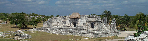
There are three major structures of interest at the Tulum site. El Castillo, the Temple of the Frescoes, and the Temple of the Descending God are the three most famous buildings. Among the more spectacular buildings here is the Temple of the Frescoes that included a lower gallery and a smaller second story gallery. The Temple of the Frescoes was used as an observatory for tracking the movements of the sun. Niched figurines of the Maya “diving god” or Venus deity decorate the facade of the temple. This “diving god” is also depicted in the Temple of the Diving God in the central precinct of the site. Above the entrance in the western wall a stucco figure of the “diving god” is still preserved, giving the temple its name. A mural can still be seen on the eastern wall that resembles that of a style that originated in highland Mexico, called the Mixteca-Puebla style, though visitors are no longer permitted to enter.
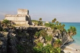
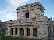
Also in the central precinct is the Castillo, which is 7.5 m (24.6 ft) tall. The Castillo was built on a previous building that was colonnaded and had a beam and mortar roof. The lintels in the upper rooms have serpent motifs carved into them. The construction of the Castillo appears to have taken place in stages. A small shrine appears to have been used as a beacon for incoming canoes. This shrine marks a break in the barrier reef that is opposite the site. Here there is a cove and landing beach in a break in the sea cliffs that would have been perfect for trading canoes coming in. This characteristic of the site may be one of the reasons the Maya founded the city of Tulum exactly here, as Tulum later became a prominent trading port during the late Postclassic.
Trading
Both coastal and land routes converged at Tulum which is apparent by the number of artifacts found in or near the site that show contacts with areas all over Central Mexico and Central America. Copper artifacts from the Mexican highlands have been found near the site, as have flint artifacts, ceramics, incense burners, and gold objects from all over the YucatánYucatán
Yucatán officially Estado Libre y Soberano de Yucatán is one of the 31 states which, with the Federal District, comprise the 32 Federal Entities of Mexico. It is divided in 106 municipalities and its capital city is Mérida....
. Salt and textiles were among some of the goods brought to Tulum by sea that would then be dispersed inland. Typical exported goods included feathers and copper objects that came from inland sources. These goods could be transported by sea to rivers such as the Río Motagua and the Río Usumacincta/Pasión system that could be taken inland giving seafaring canoes access to both the highlands and the lowlands.
The Río Motagua starts from the highlands of Guatemala and empties into the Caribbean while the Río Pasión/Ucamacincta river system also originates in the Guatemalan highlands and empties into the Gulf of Mexico. It may have been one of these seafaring canoes that Christopher Columbus first encountered off the shores of the Bay Islands of Honduras. Jade
Jade
Jade is an ornamental stone.The term jade is applied to two different metamorphic rocks that are made up of different silicate minerals:...
and obsidian
Obsidian
Obsidian is a naturally occurring volcanic glass formed as an extrusive igneous rock.It is produced when felsic lava extruded from a volcano cools rapidly with minimum crystal growth...
appear to be some of the more prestigious materials found here as the obsidian would have had to have traveled clear from Ixtepeque
Ixtepeque
Volcán Ixtepeque is a stratovolcano in southern Guatemala. It consists of several rhyolitic lava domes and basaltic cinder cones.Its name is derived from the nahuatl word for obsidian. Ixtepeque was one of the most important obsidian sources in pre-Columbian Mesoamerica....
in northern Guatemala which was nearly 700 kilometres (435 mi) away from Tulum. This huge distance coupled with the density of obsidian found at the site show that Tulum was a major center for the trading of obsidian.
Tourism
Riviera Maya
Riviera Maya, also known as the Mayan Riviera, is a tourism district following the coastal Highway 307 which parallels the Caribbean coastline of the Mexican state of Quintana Roo, located on the eastern portion of the Yucatán Peninsula...
" surrounding Cancún
Cancún
Cancún is a city of international tourism development certified by the UNWTO . Located on the northeast coast of Quintana Roo in southern Mexico, more than 1,700 km from Mexico City, the Project began operations in 1974 as Integrally Planned Center, a pioneer of FONATUR Cancún is a city of...
) has made it the most popular Maya tourist site in the Yucatan. Daily tour buses bring a constant stream of visitors to the site. The Tulum ruins are the third most-visited archaeological site in Mexico, after Teotihuacan
Teotihuacan
Teotihuacan – also written Teotihuacán, with a Spanish orthographic accent on the last syllable – is an enormous archaeological site in the Basin of Mexico, just 30 miles northeast of Mexico City, containing some of the largest pyramidal structures built in the pre-Columbian Americas...
and Chichen Itza
Chichen Itza
Chichen Itza is a large pre-Columbian archaeological site built by the Maya civilization located in the northern center of the Yucatán Peninsula, in the Municipality of Tinúm, Yucatán state, present-day Mexico....
. It is popular for the picturesque view of the Caribbean and a location just 128 km (79.5 mi) south of the popular beach resort of Cancún.
A large number of cenotes are located in the Tulum area such as Maya Blue, Naharon, Temple of Doom, Tortuga, Vacaha, Grand Cenote, Abejas, Nohoch Kiin and Carwash cenotes and cave systems.
The tourist destination is now divided into four main areas: the archaeological site, the pueblo (or town), the zona hotelera (or hotel zone) and the biosphere reserve of Sian Ka'an
Sian Ka'an
Sian Ka'an is a non profit and non governmental organization biosphere reserve formed by a group of conservationists in the municipality of Tulum in the Mexican state of Quintana Roo, whose mission is the conservation of the biodiversity...
.
In 1995, tourism came to a brief halt as the powerful Hurricane Roxanne
Hurricane Roxanne
Hurricane Roxanne caused extensive flooding in Mexico due to its erratic movement. The seventeenth storm, tenth hurricane, and the fifth and final major hurricane of the very active 1995 Atlantic hurricane season, Roxanne developed in the southwestern Caribbean Sea from an area of low pressure on...
pounded into Tulum, packing 115 mph winds. Damage was moderate.
See also
- Riviera MayaRiviera MayaRiviera Maya, also known as the Mayan Riviera, is a tourism district following the coastal Highway 307 which parallels the Caribbean coastline of the Mexican state of Quintana Roo, located on the eastern portion of the Yucatán Peninsula...
- TopoxteTopoxteTopoxte is a pre-Columbian Maya archaeological site in the Petén Basin in northern Guatemala with a long occupational history dating as far back as the Middle Preclassic. As the capital of the Ko’woj Maya, it was the largest of the few Postclassic Mesoamerican sites in the area...
- Juan Díaz (Spanish conquistador)Juan Díaz (Spanish conquistador)Juan Díaz , born in Seville, Spain, was a 16th century conquistador and the chaplain of the 1518 Grijalva expedition, the Itinerario of which he wrote....
- Juan de GrijalvaJuan de GrijalvaJuan de Grijalva was a Spanish conquistador. Some authors said he was from the same family as Diego Velázquez.He went to Hispaniola in 1508 and to Cuba in 1511....