
Hurricane Marilyn
Encyclopedia
Hurricane Marilyn was the fifteenth tropical depression and thirteenth named storm
of the unusually busy 1995 Atlantic hurricane season
, following closely on the heels of Hurricane Luis
. Hurricane Marilyn was the most powerful storm to hit the Virgin Islands
since Hurricane Hugo
of 1989
.
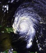
Marilyn formed late in the UTC day on September 13, and reached hurricane strength soon thereafter. Marilyn struck the Lesser Antilles
on September 14 at Category 1 strength, and intensified to nearly Category 3 strength by the time it reached the U.S. Virgin Islands. A Hurricane Hunter reconnaissance
flight reported hail
, which is unusual for tropical cyclones. After heading north past Bermuda
, Marilyn weakened and became extratropical on September 22. The remnant circulation wandered the Atlantic Ocean
from September 23 - October 1, just south of Nova Scotia
. Marilyn peaked at 115 mph (185 km/h), but was predicted to reach 125 mph (205 km/h) (maximum Category 3-status).
Marilyn is directly responsible for thirteen deaths, most due to drowning on boats or offshore.
11 000 people were left homeless on the island of St. Thomas, and estimated damages were set at $2 billion (1995 USD) in the USVI
The same area would be struck by Hurricane Bertha
the next year, while still repairing from Hurricanes Luis and Marilyn, then successively hit by Hortense
, Erika
, Georges
, José
, Lenny
and Debby
.
For the next few days, Marilyn's track took it towards the west-northwest and to the northwest, due to a weakness in the subtropical ridge. Marilyn was a Category 1
hurricane; it passed 52 mi (83.7 km) north of Barbados
and Martinique
. Marilyn passed over Dominica
, and just southwest of Guadeloupe
on September 14, bringing heavy rains and strong winds with it. Marilyn continued on its northwesterly track, making landfall in the U.S. Virgin Islands on September 15, packing winds of 110 mi/h, a strong Category 2 strength hurricane. The eyewall, east-southeast of the center of Marilyn, passed over Saint Thomas
later that day. After passing over Puerto Rico
, Marilyn entered back into the Atlantic Ocean on September 16.
 A low had formed near Marilyn, which may have enhanced outflow from the system. An eye formed in the center of Marilyn, and the storm reached a peak intensity of 949 millibars and winds of only 115 mph (185 km/h), a lower-end Category 3 hurricane. At this time, Marilyn was predicted to peak in wind speeds of 120–125 mph (190–195 km/h).
Reconnaissance data found a concentric pair of eyewall wind maxima. Marilyn started weakening rapidly, falling from peak-level winds of 141 mi/h down to 102 mph (164 km/h). The central pressure also rose up 20 mbar
s in only 10 hours. This rapid weakening was caused by westerly shear and dry air entrained in the system, a decaying eyewall, and especially cool waters upwelled from the previous powerful storm, Hurricane Luis
. As Marilyn weakened to Category 1 hurricane status and moved north-northwest, it passed about 174 mi (280 km) west of Bermuda
on September 19. As Marilyn encountered more westerly shear, it weakened to below hurricane status and made its extratropical transition on September 20, centered in the northeastern Atlantic. The remnant circulation continued to erratically move through the central Atlantic Ocean for another 10 days before being absorbed by a frontal low on September 30.
A Hurricane Hunter reconnaissance flight reported hail, which is unusual for tropical cyclones.
 Seventeen watches and/or warnings were issued in association with Marilyn. The first two were a tropical storm watch and a tropical storm warning issued on Barbados
, St. Vincent
, Grenadines, St. Lucia and Grenada on September 12 at 2200 UTC. Five hours later, a tropical storm watch was issued for Trinidad
and Tobago
. A tropical storm warning was issued for St. Lucia, St. Vincent, Grenadines
, Grenada
and Tobago at 900 UTC September 13. At 2100 UTC, a Hurricane Warning was issued for Barbados
, St. Vincent, Grenadines
, St. Lucia and a hurricane watch for Dominica
. A hurricane watch as released for Martinique on September 14. The 2100 UTC September 13 was extended for the Grenadines through St. Martin, except Guadeloupe, St. Barthelemy and French portion of St. Martin. At 1500 UTC, Puerto Rico was put under a Hurricane Watch. At 1700 UTC, Guadeloupe, St. Barthelemy, and French portion of St. Martin were put under a hurricane watch. Four hours later, Puerto Rico
, U.S. and British Virgin Islands
, and Guadeloupe were put under a hurricane warning.
Throughout the night, several watches and warnings were discontinued. At 1500 UTC September 15, Dominican Republic
from Cabrera to Cabo Engano
were put under a hurricane watch as Marilyn approached. During the night of September 16, all currently active watches and warnings were discontinued. At around the same time, a new Hurricane watch was released for Turks and Caicos and Mayaguana
, Acklins
, and the Crooked Islands of the southeastern Bahamas. This warning was discontinued within 48 hours. At 1500 UTC September 18, Bermuda
came under a Tropical Storm Watch, which was upgraded to a warning in six hours. The warning was discontinued on September 19.
The 250,000 residents of Barbados
spent the night of September 13 in shelters.
Marilyn caused tremendous damage and 16 deaths throughout the United States Virgin Islands
and Puerto Rico
. Rainfalls from Marilyn off of land were estimated from four-seven inc from September 13 and September 14.
peaked at 9.06 in (230.1 mm) in Morne Rouge, 8.94 in (227.1 mm) in Ajoupa Bouillon, 6.4 in (162.6 mm) in Saint Pierre, ranging as low as 6 in (152.4 mm) in Ducos. The highest wind gust reported was 80 mi/h in Trinite, the location of the only recorded sustained winds in Martinique, which was 58 mph (93.3 km/h).
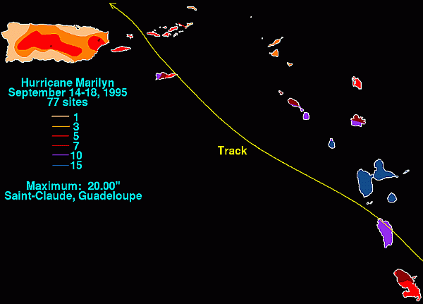
Hurricane Marilyn moved directly across the southern part of Basse-Terre Island
in the night of September 14-15 1995, bringing the highest known rainfall totals to the island from a tropical cyclone.
Rainfalls over 12-hours in Guadeloupe
were up to 20 in (508 mm) in Saint-Claude, 19.09 in (484.9 mm) in Guillard-Basse-Terre and 17.63 in (447.8 mm) in Gaba. The highest wind gust reported in Guadeloupe was 84 mph (135.2 km/h) in Marie-Galante. The next ones were near 52 mi/h in Raizet with maximal wind gust at 68 mi/h and 61 mi/h in Desirade.
Minimal pressure recorded at 989 mb (29.20 In Hg) in Basse-Terre.
Damage was moderate in the south, due to the massive amount of rainfall.
Marilyn was one of the three cyclones that affected the region in 1995 after Tropical Storm Iris
and Hurricane Luis.
 The highest wind speed left by Marilyn after passing over the island of St. Croix
was 100 mi/h. The highest rainfalls reported were 11.67 in (296.4 mm) in Annually, 9.96 in (253 mm) in Red Hook Bay and 5.25 in (133.4 mm) in Granard. The highest storm surge reported was 6.6 ft (2 m) in St. Thomas
and 6 ft (1.8 m) in St. Croix
. According to NOAA, The storm surge in the U.S. Virgin Islands reached 6 to 7 ft (2.1 m), with an isolated storm tide of 11.7 ft (3.6 m) reported on St. Croix. Rainfall totals reached about 10 in in St. Croix and St. Thomas.
The highest reported gusts were 129 mi/h in a Noncommissioned Automated Surface Observing System and 95 mi/h gusts in Sailboat Puffin at Green Cay. The highest sustained winds were 105 mi/h in a Noncommissioned Automated Surface Observing System.
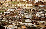
Marilyn was directly responsible for seven deaths, most due to drowning on boats or offshore. Ten thousand people were left homeless on St. Thomas, and most buildings sustained some damage.
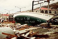
The island of St. Thomas was the hardest hit by the storm, where about 80% of the homes and businesses were damaged or destroyed, including the hospital and the water desalination plant; five people were killed. Storm surge in the Charlotte Amalie harbor beached the USCGC Point Ledge and damaged many smaller boats. Elsewhere in the territory, there was moderate to severe damage on St. Croix
and St. John
.
President Bill Clinton
declared the U.S. Virgin Islands a federal disaster area, making it available to federal aid.
International Airport, and 2.45 in (62.2 mm) at Roosevelt Roads Naval Station
. The highest gusts reported were 125 mi/h in Culebra, 60 mi/h at Roosevelt Roads Naval Station
and 50 mi/h at a non-commissioned Automated Surface Observing System. The highest recorded sustained winds was 41 mi/h at Roosevelt Roads Naval Station. Marilyn passed over the islands of Vieques
and Culebra
, where it caused much damage.
There were reports of extensive flash flooding across northern and eastern Puerto Rico
, and 12,000 people were forced to ride out the storm in shelters. One person was killed in Culebra. President Bill Clinton
declared Puerto Rico a federal disaster area, making it available to federal aid.
100 homes on Culebra Island, twenty mi (32 km) east of Puerto Rico, were destroyed by Marilyn. Another two hundred homes on the island were damaged.
was 50 mi/h. The Antigua Meteorological Service reported that the island had extensive flooding and damage to banana trees. The other damage reported was from the wind.
reported sustained winds of 45 mph and a highest gust of 60 mi/h. Antigua
reported sustained winds of just 35 mi/h, tropical depression-strength. In St. Maarten, sustained winds were 42.5 mi/h and the peak gust was 61 mi/h. Rainfalls in St. Maarten peaked at 3.35 in (85.1 mm) in an unknown location. The New York Times
reported that the British Virgin Islands
had little to no damage from Marilyn. The highest gust in Saint-Barthelemy was 59 mi/h and the highest sustained winds of 45 mi/h was reported.
 The exact figure for damages in the U.S. Virgin Islands and Puerto Rico is not available, although the American Insurance Services Group set the combined damage at $875 million USD. However, the Federal Emergency Management Agency
(FEMA) estimated the damage cost as $1 billion USD while an economic research group in the U.S. Virgin Islands estimated the damage to be at $3 billion USD. As of 1995, the estimated damages to St. Thomas were set at $1.5 billion (1995 USD).
The economic impact to the islands was severe in St. John and particularly to St. Thomas, which are heavily dependent on tourism
.
Aside from high winds and seas, one possible explanation for the storm's heavy damage may have been complacency on the part of local island populations. Marilyn followed on the heels of Luis
, a more powerful Category 4
hurricane initially predicted to pass very close to St. Thomas. This prediction prompted locals to be particularly thorough in their pre-storm preparations; however, the hurricane passed further away from the island and caused relatively moderate damage. This may have caused islanders to prematurely relax, as Marilyn was a much smaller hurricane in appearance than Luis. Another factual reason was substantial difference in wind speed forecasts measured at sea-level, Cyril King Airport on St. Thomas and those measured on homes throughout the Island hillsides & broadcast from sites off the Island, such as Puerto Rico and the US Mainland. Sea-level Airport readings showed 75-85 MPH gusting winds, whereas measurements
on hillside homes showed 100-130 MPH gusting winds, similar to Mainland wind forecasts. Some neighbors with hurricane devastated homes in St. Thomas compared wind charts of their homes'smashed wind meters indicating 120 - 140 MPH! Amazing photos of the winds devastation (sofas blown thru sliding glass doors then into pools, clothing & possessions blown out of house down the hillsides, etc.) were almost funny.
and the U.S. Virgin Islands. Officials of FEMA set up camps on the islands to give out food, water and shelter supplies.
 80% of the homes on St. Thomas were destroyed or damaged, 1/2 being uninhabitable. Also, 20-30% of businesses were destroyed. Five supply distribution sites were being operated by the Virgin Islands Territorial Emergency Management Agency (VITEMA). More than 2,100 federal agency personnel had been deployed to help out with the cleanup from Hurricane Marilyn. Four contracts were quickly accepted for immediate building repairs. Diving teams were sent to check for harbor damage and United States Navy
Seabees started working on repairing public buildings. Military and security forces included about 500 Army, Air Force, and Navy personnel, 500 National Guardsmen, and 500 federal law enforcement personnel. The airport in St. Thomas was open for flight using a mobile control tower. The St. Thomas hospital was open, but was running on generators.
The first FEMA Disaster Recovery Centers opened on 23 September on St. Thomas. A reported indicated that by 11 October 1500 loans were granted for home repair, mostly for under $2500. Over 19,000 disaster housing applications were filed with over 2800 being accepted. About 5000 of 15,000 assigned inspections were completed. Over 7800 applications for Individual and Family Grants had been received and, of the 4,000 SBA loan applications filed, 43 had been approved for a total of $744,100 - an average loan of $17,300.
In all, Marilyn caused $1.5 billion (1995 USD) in damage, killing 13 people in its path.
s to affect the Leeward Islands especially Dominica
and Guadeloupe
in a short period of time of the 1995 season, the first being Hurricane Iris
, late August and the second being Hurricane Luis
, ten days before.
Due to intense destruction, the name Marilyn was retired in the spring of 1996, and will never again be used for an Atlantic hurricane. It was replaced with the name Michelle
for the 2001 season
which was retired as well in the spring of 2002, it was replaced by Melissa for the 2007 season
.
Storm
A storm is any disturbed state of an astronomical body's atmosphere, especially affecting its surface, and strongly implying severe weather...
of the unusually busy 1995 Atlantic hurricane season
1995 Atlantic hurricane season
The 1995 Atlantic hurricane season was the third most active Atlantic hurricane season on record. It officially began on June 1, 1995, and lasted until November 30, 1995. These dates conventionally delimit the period of each year when most tropical cyclones form in the north Atlantic ocean...
, following closely on the heels of Hurricane Luis
Hurricane Luis
Hurricane Luis was one of the deadliest and most destructive hurricanes of the 1995 Atlantic hurricane season, with maximum sustained winds of 140 mph . The storm was the twelfth tropical storm, sixth hurricane, and second major hurricane of the season...
. Hurricane Marilyn was the most powerful storm to hit the Virgin Islands
Virgin Islands
The Virgin Islands are the western island group of the Leeward Islands, which are the northern part of the Lesser Antilles, which form the border between the Caribbean Sea and the Atlantic Ocean...
since Hurricane Hugo
Hurricane Hugo
Hurricane Hugo was a classical, destructive and rare Cape Verde-type hurricane which struck the Caribbean islands of Guadeloupe, Montserrat, St. Croix, Puerto Rico and the USA mainland in South Carolina as a Category 4 hurricane during September of the 1989 Atlantic hurricane season...
of 1989
1989 Atlantic hurricane season
The 1989 Atlantic hurricane season was an active season that produced fifteen tropical cyclones, eleven named storms, seven hurricanes, and two major hurricanes. The season was officially designated from June 1, 1989, to November 30, 1989, dates which conventionally...
.
Marilyn formed late in the UTC day on September 13, and reached hurricane strength soon thereafter. Marilyn struck the Lesser Antilles
Lesser Antilles
The Lesser Antilles are a long, partly volcanic island arc in the Western Hemisphere. Most of its islands form the eastern boundary of the Caribbean Sea with the Atlantic Ocean, with the remainder located in the southern Caribbean just north of South America...
on September 14 at Category 1 strength, and intensified to nearly Category 3 strength by the time it reached the U.S. Virgin Islands. A Hurricane Hunter reconnaissance
Reconnaissance
Reconnaissance is the military term for exploring beyond the area occupied by friendly forces to gain information about enemy forces or features of the environment....
flight reported hail
Hail
Hail is a form of solid precipitation. It consists of balls or irregular lumps of ice, each of which is referred to as a hail stone. Hail stones on Earth consist mostly of water ice and measure between and in diameter, with the larger stones coming from severe thunderstorms...
, which is unusual for tropical cyclones. After heading north past Bermuda
Bermuda
Bermuda is a British overseas territory in the North Atlantic Ocean. Located off the east coast of the United States, its nearest landmass is Cape Hatteras, North Carolina, about to the west-northwest. It is about south of Halifax, Nova Scotia, Canada, and northeast of Miami, Florida...
, Marilyn weakened and became extratropical on September 22. The remnant circulation wandered the Atlantic Ocean
Atlantic Ocean
The Atlantic Ocean is the second-largest of the world's oceanic divisions. With a total area of about , it covers approximately 20% of the Earth's surface and about 26% of its water surface area...
from September 23 - October 1, just south of Nova Scotia
Nova Scotia
Nova Scotia is one of Canada's three Maritime provinces and is the most populous province in Atlantic Canada. The name of the province is Latin for "New Scotland," but "Nova Scotia" is the recognized, English-language name of the province. The provincial capital is Halifax. Nova Scotia is the...
. Marilyn peaked at 115 mph (185 km/h), but was predicted to reach 125 mph (205 km/h) (maximum Category 3-status).
Marilyn is directly responsible for thirteen deaths, most due to drowning on boats or offshore.
11 000 people were left homeless on the island of St. Thomas, and estimated damages were set at $2 billion (1995 USD) in the USVI
United States Virgin Islands
The Virgin Islands of the United States are a group of islands in the Caribbean that are an insular area of the United States. The islands are geographically part of the Virgin Islands archipelago and are located in the Leeward Islands of the Lesser Antilles.The U.S...
The same area would be struck by Hurricane Bertha
Hurricane Bertha (1996)
Hurricane Bertha was a strong, early season major hurricane which impacted areas from the Leeward Islands to Atlantic Canada. Bertha originated from a tropical wave which moved off the eastern coast of Africa in early July. By July 3, an area of low pressure developed along the wave...
the next year, while still repairing from Hurricanes Luis and Marilyn, then successively hit by Hortense
Hurricane Hortense
Hurricane Hortense was the eighth tropical storm, sixth hurricane, and second Category 4 hurricane of the 1996 Atlantic hurricane season. Lasting from September 3 to September 16, Hortense brought torrential flooding as it moved through the Lesser Antilles, Puerto Rico, and Dominican Republic...
, Erika
Hurricane Erika (1997)
Hurricane Erika was the strongest and longest-lasting tropical cyclone in the 1997 Atlantic hurricane season. Erika developed from a tropical wave on September 3 and moved west-northwestward across the tropical Atlantic Ocean; it steadily intensified until it attained hurricane status on September...
, Georges
Hurricane Georges
Hurricane Georges was a very destructive, powerful and long-lived Cape Verde-type Category 4 hurricane. Georges was the seventh tropical storm, fourth hurricane, and second major hurricane of the 1998 Atlantic hurricane season...
, José
Hurricane Jose (1999)
Hurricane Jose was a Category 2 hurricane that affected the Leeward Islands between October 20 and October 25, 1999. It was the tenth named storm, and eighth hurricane of the 1999 Atlantic hurricane season. Jose formed on October 17 while east of the Windward Islands. The storm quickly...
, Lenny
Hurricane Lenny
Hurricane Lenny was the strongest November Atlantic hurricane on record. It was the twelfth tropical storm, eighth hurricane, and record-breaking fifth Category 4 hurricane in the 1999 Atlantic hurricane season. Lenny formed on November 13 in the western Caribbean Sea, and maintained an...
and Debby
Hurricane Debby (2000)
Hurricane Debby was a minimal Category 1 hurricane that formed in mid-to-late August of the year 2000. Debby formed east of the Windward Islands on August 19, 2000, becoming the seventh tropical cyclone of the 2000 Atlantic hurricane season. The storm strengthened to a hurricane the next day,...
.
Meteorological history
Marilyn's origins were from a tropical wave that formed off the African coast on September 7. Large, low-level winds were included in the wave's circulation, but little convection existed. The system continued west for a few days at about 19 mph (30.6 km/h) next to an anticyclonic aloft. On September 12, satellite pictures viewed the disorganized wave and declared it Tropical Depression Fifteen, after convection had increased. Tropical Depression Fifteen strengthened rapidly, becoming Tropical Storm Marilyn six hours later. One day after being named, Marilyn was upgraded to hurricane status, while turning on a more northwesterly track.For the next few days, Marilyn's track took it towards the west-northwest and to the northwest, due to a weakness in the subtropical ridge. Marilyn was a Category 1
Saffir-Simpson Hurricane Scale
The Saffir–Simpson Hurricane Scale , or the Saffir–Simpson Hurricane Wind Scale , classifies hurricanes — Western Hemisphere tropical cyclones that exceed the intensities of tropical depressions and tropical storms — into five categories distinguished by the intensities of their sustained winds...
hurricane; it passed 52 mi (83.7 km) north of Barbados
Barbados
Barbados is an island country in the Lesser Antilles. It is in length and as much as in width, amounting to . It is situated in the western area of the North Atlantic and 100 kilometres east of the Windward Islands and the Caribbean Sea; therein, it is about east of the islands of Saint...
and Martinique
Martinique
Martinique is an island in the eastern Caribbean Sea, with a land area of . Like Guadeloupe, it is an overseas region of France, consisting of a single overseas department. To the northwest lies Dominica, to the south St Lucia, and to the southeast Barbados...
. Marilyn passed over Dominica
Dominica
Dominica , officially the Commonwealth of Dominica, is an island nation in the Lesser Antilles region of the Caribbean Sea, south-southeast of Guadeloupe and northwest of Martinique. Its size is and the highest point in the country is Morne Diablotins, which has an elevation of . The Commonwealth...
, and just southwest of Guadeloupe
Guadeloupe
Guadeloupe is an archipelago located in the Leeward Islands, in the Lesser Antilles, with a land area of 1,628 square kilometres and a population of 400,000. It is the first overseas region of France, consisting of a single overseas department. As with the other overseas departments, Guadeloupe...
on September 14, bringing heavy rains and strong winds with it. Marilyn continued on its northwesterly track, making landfall in the U.S. Virgin Islands on September 15, packing winds of 110 mi/h, a strong Category 2 strength hurricane. The eyewall, east-southeast of the center of Marilyn, passed over Saint Thomas
Saint Thomas, U.S. Virgin Islands
Saint Thomas is an island in the Caribbean Sea and with the islands of Saint John, Saint Croix, and Water Island a county and constituent district of the United States Virgin Islands , an unincorporated territory of the United States. Located on the island is the territorial capital and port of...
later that day. After passing over Puerto Rico
Puerto Rico
Puerto Rico , officially the Commonwealth of Puerto Rico , is an unincorporated territory of the United States, located in the northeastern Caribbean, east of the Dominican Republic and west of both the United States Virgin Islands and the British Virgin Islands.Puerto Rico comprises an...
, Marilyn entered back into the Atlantic Ocean on September 16.
Reconnaissance data found a concentric pair of eyewall wind maxima. Marilyn started weakening rapidly, falling from peak-level winds of 141 mi/h down to 102 mph (164 km/h). The central pressure also rose up 20 mbar
Bar (unit)
The bar is a unit of pressure equal to 100 kilopascals, and roughly equal to the atmospheric pressure on Earth at sea level. Other units derived from the bar are the megabar , kilobar , decibar , centibar , and millibar...
s in only 10 hours. This rapid weakening was caused by westerly shear and dry air entrained in the system, a decaying eyewall, and especially cool waters upwelled from the previous powerful storm, Hurricane Luis
Hurricane Luis
Hurricane Luis was one of the deadliest and most destructive hurricanes of the 1995 Atlantic hurricane season, with maximum sustained winds of 140 mph . The storm was the twelfth tropical storm, sixth hurricane, and second major hurricane of the season...
. As Marilyn weakened to Category 1 hurricane status and moved north-northwest, it passed about 174 mi (280 km) west of Bermuda
Bermuda
Bermuda is a British overseas territory in the North Atlantic Ocean. Located off the east coast of the United States, its nearest landmass is Cape Hatteras, North Carolina, about to the west-northwest. It is about south of Halifax, Nova Scotia, Canada, and northeast of Miami, Florida...
on September 19. As Marilyn encountered more westerly shear, it weakened to below hurricane status and made its extratropical transition on September 20, centered in the northeastern Atlantic. The remnant circulation continued to erratically move through the central Atlantic Ocean for another 10 days before being absorbed by a frontal low on September 30.
A Hurricane Hunter reconnaissance flight reported hail, which is unusual for tropical cyclones.
Preparations
Barbados
Barbados is an island country in the Lesser Antilles. It is in length and as much as in width, amounting to . It is situated in the western area of the North Atlantic and 100 kilometres east of the Windward Islands and the Caribbean Sea; therein, it is about east of the islands of Saint...
, St. Vincent
Saint Vincent (island)
Saint Vincent is a volcanic island in the Caribbean. It is the largest island of the chain called Saint Vincent and the Grenadines. It is located in the Caribbean Sea, between Saint Lucia and Grenada. It is composed of partially submerged volcanic mountains...
, Grenadines, St. Lucia and Grenada on September 12 at 2200 UTC. Five hours later, a tropical storm watch was issued for Trinidad
Trinidad
Trinidad is the larger and more populous of the two major islands and numerous landforms which make up the island nation of Trinidad and Tobago. It is the southernmost island in the Caribbean and lies just off the northeastern coast of Venezuela. With an area of it is also the fifth largest in...
and Tobago
Tobago
Tobago is the smaller of the two main islands that make up the Republic of Trinidad and Tobago. It is located in the southern Caribbean, northeast of the island of Trinidad and southeast of Grenada. The island lies outside the hurricane belt...
. A tropical storm warning was issued for St. Lucia, St. Vincent, Grenadines
Grenadines
The Grenadines is a Caribbean island chain of over 600 islands in the Windward Islands.-Geographic boundaries:They are divided between the island nations of Saint Vincent and the Grenadines and Grenada. They lie between the islands of Saint Vincent in the north and Grenada in the south. Neither...
, Grenada
Grenada
Grenada is an island country and Commonwealth Realm consisting of the island of Grenada and six smaller islands at the southern end of the Grenadines in the southeastern Caribbean Sea...
and Tobago at 900 UTC September 13. At 2100 UTC, a Hurricane Warning was issued for Barbados
Barbados
Barbados is an island country in the Lesser Antilles. It is in length and as much as in width, amounting to . It is situated in the western area of the North Atlantic and 100 kilometres east of the Windward Islands and the Caribbean Sea; therein, it is about east of the islands of Saint...
, St. Vincent, Grenadines
Grenadines
The Grenadines is a Caribbean island chain of over 600 islands in the Windward Islands.-Geographic boundaries:They are divided between the island nations of Saint Vincent and the Grenadines and Grenada. They lie between the islands of Saint Vincent in the north and Grenada in the south. Neither...
, St. Lucia and a hurricane watch for Dominica
Dominica
Dominica , officially the Commonwealth of Dominica, is an island nation in the Lesser Antilles region of the Caribbean Sea, south-southeast of Guadeloupe and northwest of Martinique. Its size is and the highest point in the country is Morne Diablotins, which has an elevation of . The Commonwealth...
. A hurricane watch as released for Martinique on September 14. The 2100 UTC September 13 was extended for the Grenadines through St. Martin, except Guadeloupe, St. Barthelemy and French portion of St. Martin. At 1500 UTC, Puerto Rico was put under a Hurricane Watch. At 1700 UTC, Guadeloupe, St. Barthelemy, and French portion of St. Martin were put under a hurricane watch. Four hours later, Puerto Rico
Puerto Rico
Puerto Rico , officially the Commonwealth of Puerto Rico , is an unincorporated territory of the United States, located in the northeastern Caribbean, east of the Dominican Republic and west of both the United States Virgin Islands and the British Virgin Islands.Puerto Rico comprises an...
, U.S. and British Virgin Islands
British Virgin Islands
The Virgin Islands, often called the British Virgin Islands , is a British overseas territory and overseas territory of the European Union, located in the Caribbean to the east of Puerto Rico. The islands make up part of the Virgin Islands archipelago, the remaining islands constituting the U.S...
, and Guadeloupe were put under a hurricane warning.
Throughout the night, several watches and warnings were discontinued. At 1500 UTC September 15, Dominican Republic
Dominican Republic
The Dominican Republic is a nation on the island of La Hispaniola, part of the Greater Antilles archipelago in the Caribbean region. The western third of the island is occupied by the nation of Haiti, making Hispaniola one of two Caribbean islands that are shared by two countries...
from Cabrera to Cabo Engano
Cabo Engaño
Cabo Engaño is the easternmost point of the island of Hispaniola, on the territory of the Dominican Republic. Punta Cana International Airport, the nation's busiest, lies slightly south of the cape....
were put under a hurricane watch as Marilyn approached. During the night of September 16, all currently active watches and warnings were discontinued. At around the same time, a new Hurricane watch was released for Turks and Caicos and Mayaguana
Mayaguana
Mayaguana is the most easterly island and district of the Bahamas. It is one of only a few Bahamian islands which retain their Lucayan names. The population of Mayaguana in the 2000 census was 259, amounting to an estimate 312 in 2010...
, Acklins
Acklins
Acklins is an island and district of the Bahamas.It is one of a group of islands arranged along a large, shallow lagoon called the Bight of Acklins, of which the largest are Crooked Island in the north and Acklins in the southeast, and the smaller are Long Cay [ 8sq mi] in the northwest, and...
, and the Crooked Islands of the southeastern Bahamas. This warning was discontinued within 48 hours. At 1500 UTC September 18, Bermuda
Bermuda
Bermuda is a British overseas territory in the North Atlantic Ocean. Located off the east coast of the United States, its nearest landmass is Cape Hatteras, North Carolina, about to the west-northwest. It is about south of Halifax, Nova Scotia, Canada, and northeast of Miami, Florida...
came under a Tropical Storm Watch, which was upgraded to a warning in six hours. The warning was discontinued on September 19.
The 250,000 residents of Barbados
Barbados
Barbados is an island country in the Lesser Antilles. It is in length and as much as in width, amounting to . It is situated in the western area of the North Atlantic and 100 kilometres east of the Windward Islands and the Caribbean Sea; therein, it is about east of the islands of Saint...
spent the night of September 13 in shelters.
Impact
| County/Region | Deaths | Damage | Source |
|---|---|---|---|
| St. Thomas Saint Thomas, U.S. Virgin Islands Saint Thomas is an island in the Caribbean Sea and with the islands of Saint John, Saint Croix, and Water Island a county and constituent district of the United States Virgin Islands , an unincorporated territory of the United States. Located on the island is the territorial capital and port of... |
8 | $1.5 billion | |
| St. Croix | 1 | $350 million | |
| St. John Saint John, U.S. Virgin Islands Saint John is an island in the Caribbean Sea and a constituent district of the United States Virgin Islands , an unincorporated territory of the United States. St... |
1 | $150 million | |
| Puerto Rico Puerto Rico Puerto Rico , officially the Commonwealth of Puerto Rico , is an unincorporated territory of the United States, located in the northeastern Caribbean, east of the Dominican Republic and west of both the United States Virgin Islands and the British Virgin Islands.Puerto Rico comprises an... |
1 | $300 million | |
| Unknown | 5 | ||
| Total | 16 (8) | ~$2.3 billion |
Marilyn caused tremendous damage and 16 deaths throughout the United States Virgin Islands
United States Virgin Islands
The Virgin Islands of the United States are a group of islands in the Caribbean that are an insular area of the United States. The islands are geographically part of the Virgin Islands archipelago and are located in the Leeward Islands of the Lesser Antilles.The U.S...
and Puerto Rico
Puerto Rico
Puerto Rico , officially the Commonwealth of Puerto Rico , is an unincorporated territory of the United States, located in the northeastern Caribbean, east of the Dominican Republic and west of both the United States Virgin Islands and the British Virgin Islands.Puerto Rico comprises an...
. Rainfalls from Marilyn off of land were estimated from four-seven inc from September 13 and September 14.
Martinique
Rainfalls in MartiniqueMartinique
Martinique is an island in the eastern Caribbean Sea, with a land area of . Like Guadeloupe, it is an overseas region of France, consisting of a single overseas department. To the northwest lies Dominica, to the south St Lucia, and to the southeast Barbados...
peaked at 9.06 in (230.1 mm) in Morne Rouge, 8.94 in (227.1 mm) in Ajoupa Bouillon, 6.4 in (162.6 mm) in Saint Pierre, ranging as low as 6 in (152.4 mm) in Ducos. The highest wind gust reported was 80 mi/h in Trinite, the location of the only recorded sustained winds in Martinique, which was 58 mph (93.3 km/h).
Guadeloupe
| Wettest tropical cyclones in Guadeloupe Highest known recorded totals |
||||
|---|---|---|---|---|
| Precipitation | Storm | Measurement station |
||
| Rank | (mm) | (in) | ||
| 1 | 600 mm | 22.23 inches | Marilyn 1995 Hurricane Marilyn Hurricane Marilyn was the fifteenth tropical depression and thirteenth named storm of the unusually busy 1995 Atlantic hurricane season, following closely on the heels of Hurricane Luis. Hurricane Marilyn was the most powerful storm to hit the Virgin Islands since Hurricane Hugo of 1989.Marilyn... |
La Grande Soufrière La Grande Soufrière La Grande Soufrière, , is an active stratovolcano located on the French island of Basse-Terre, in Guadeloupe. It is the tallest mountain in the Lesser Antilles, and rises 1,467 m high.... |
| 2 | 582 mm | inches | Luis 1995 Hurricane Luis Hurricane Luis was one of the deadliest and most destructive hurricanes of the 1995 Atlantic hurricane season, with maximum sustained winds of 140 mph . The storm was the twelfth tropical storm, sixth hurricane, and second major hurricane of the season... |
Dent de l'est (Soufrière) |
| 3 | 466 mm | inches | Lenny 1999 Hurricane Lenny Hurricane Lenny was the strongest November Atlantic hurricane on record. It was the twelfth tropical storm, eighth hurricane, and record-breaking fifth Category 4 hurricane in the 1999 Atlantic hurricane season. Lenny formed on November 13 in the western Caribbean Sea, and maintained an... |
http://www.meteo.fr/temps/domtom/antilles/pack-public/cyclone/traj/traj99/special/lenny.htm |
| 4 | 389 mm | inches | Hugo 1989 Hurricane Hugo Hurricane Hugo was a classical, destructive and rare Cape Verde-type hurricane which struck the Caribbean islands of Guadeloupe, Montserrat, St. Croix, Puerto Rico and the USA mainland in South Carolina as a Category 4 hurricane during September of the 1989 Atlantic hurricane season... |
|
| 5 | 318 mm | 12.50 inches | Hortense 1996 Hurricane Hortense Hurricane Hortense was the eighth tropical storm, sixth hurricane, and second Category 4 hurricane of the 1996 Atlantic hurricane season. Lasting from September 3 to September 16, Hortense brought torrential flooding as it moved through the Lesser Antilles, Puerto Rico, and Dominican Republic... |
Maison du Volcan http://www.nhc.noaa.gov/1996hortense.html |
| 6 | 300 mm | 11.81 inches | Jeanne 2004 Hurricane Jeanne Hurricane Jeanne was the deadliest hurricane in the 2004 Atlantic hurricane season. It was the tenth named storm, the seventh hurricane, and the fifth major hurricane of the season, as well as the third hurricane and fourth named storm of the season to make landfall in Florida... |
|
| 7 | 223 mm | 8.79 inches | Cleo 1964 Hurricane Cleo Hurricane Cleo was the third named storm, first hurricane, and first major hurricane of the 1964 Atlantic hurricane season. Cleo was one of the longest-lived storms of the season... |
|
| 8 | 200 mm | 7.90 inches | Erika 2009 Tropical Storm Erika (2009) Tropical Storm Erika was a short-lived tropical cyclone that had minor impacts in the Lesser Antilles. The fifth named storm of the 2009 Atlantic hurricane season, Erika originated out of a tropical wave on September 1 near the Lesser Antilles. Although it was a disorganized system, it was... |
|
| 9 | 165.3 mm | 6.55 inches | Earl 2010 Hurricane Earl (2010) Hurricane Earl was a long-lived, powerful tropical cyclone which became the first major hurricane to threaten New England since Hurricane Bob in 1991. The fifth named storm of the 2010 season, Earl developed out of a tropical wave roughly west of the Cape Verde Islands on August 25... |
Sainte-Rose (Viard) http://www.meteo.fr/temps/domtom/antilles/pack-public/cyclone/saison2010/earl_%20gd_idn.pdf |
| 10 | 146 mm | inches | Georges 1998 Hurricane Georges Hurricane Georges was a very destructive, powerful and long-lived Cape Verde-type Category 4 hurricane. Georges was the seventh tropical storm, fourth hurricane, and second major hurricane of the 1998 Atlantic hurricane season... |
Goyave |
Hurricane Marilyn moved directly across the southern part of Basse-Terre Island
Basse-Terre Island
Basse-Terre Island is the name of the western-half of Guadeloupe proper, in the Lesser Antilles. It is separated from the other half of Guadeloupe proper, Grande-Terre, by a narrow sea channel called the Rivière Salée ....
in the night of September 14-15 1995, bringing the highest known rainfall totals to the island from a tropical cyclone.
Rainfalls over 12-hours in Guadeloupe
Guadeloupe
Guadeloupe is an archipelago located in the Leeward Islands, in the Lesser Antilles, with a land area of 1,628 square kilometres and a population of 400,000. It is the first overseas region of France, consisting of a single overseas department. As with the other overseas departments, Guadeloupe...
were up to 20 in (508 mm) in Saint-Claude, 19.09 in (484.9 mm) in Guillard-Basse-Terre and 17.63 in (447.8 mm) in Gaba. The highest wind gust reported in Guadeloupe was 84 mph (135.2 km/h) in Marie-Galante. The next ones were near 52 mi/h in Raizet with maximal wind gust at 68 mi/h and 61 mi/h in Desirade.
Minimal pressure recorded at 989 mb (29.20 In Hg) in Basse-Terre.
Damage was moderate in the south, due to the massive amount of rainfall.
Marilyn was one of the three cyclones that affected the region in 1995 after Tropical Storm Iris
Tropical Storm Iris
The name Iris was used for three tropical cyclones in the Atlantic Ocean.* * 1989's Tropical Storm Iris - failed to get very strong or threaten land due to interaction with Hurricane Hugo, but dropped heavy rain on areas already drenched by Hugo.* 1995's Hurricane Iris - moved up Leeward Islands,...
and Hurricane Luis.
U.S. Virgin Islands
Saint Croix, U.S. Virgin Islands
Saint Croix is an island in the Caribbean Sea, and a county and constituent district of the United States Virgin Islands , an unincorporated territory of the United States. Formerly the Danish West Indies, they were sold to the United States by Denmark in the Treaty of the Danish West Indies of...
was 100 mi/h. The highest rainfalls reported were 11.67 in (296.4 mm) in Annually, 9.96 in (253 mm) in Red Hook Bay and 5.25 in (133.4 mm) in Granard. The highest storm surge reported was 6.6 ft (2 m) in St. Thomas
Saint Thomas, U.S. Virgin Islands
Saint Thomas is an island in the Caribbean Sea and with the islands of Saint John, Saint Croix, and Water Island a county and constituent district of the United States Virgin Islands , an unincorporated territory of the United States. Located on the island is the territorial capital and port of...
and 6 ft (1.8 m) in St. Croix
Saint Croix, U.S. Virgin Islands
Saint Croix is an island in the Caribbean Sea, and a county and constituent district of the United States Virgin Islands , an unincorporated territory of the United States. Formerly the Danish West Indies, they were sold to the United States by Denmark in the Treaty of the Danish West Indies of...
. According to NOAA, The storm surge in the U.S. Virgin Islands reached 6 to 7 ft (2.1 m), with an isolated storm tide of 11.7 ft (3.6 m) reported on St. Croix. Rainfall totals reached about 10 in in St. Croix and St. Thomas.
The highest reported gusts were 129 mi/h in a Noncommissioned Automated Surface Observing System and 95 mi/h gusts in Sailboat Puffin at Green Cay. The highest sustained winds were 105 mi/h in a Noncommissioned Automated Surface Observing System.
Marilyn was directly responsible for seven deaths, most due to drowning on boats or offshore. Ten thousand people were left homeless on St. Thomas, and most buildings sustained some damage.
The island of St. Thomas was the hardest hit by the storm, where about 80% of the homes and businesses were damaged or destroyed, including the hospital and the water desalination plant; five people were killed. Storm surge in the Charlotte Amalie harbor beached the USCGC Point Ledge and damaged many smaller boats. Elsewhere in the territory, there was moderate to severe damage on St. Croix
Saint Croix, U.S. Virgin Islands
Saint Croix is an island in the Caribbean Sea, and a county and constituent district of the United States Virgin Islands , an unincorporated territory of the United States. Formerly the Danish West Indies, they were sold to the United States by Denmark in the Treaty of the Danish West Indies of...
and St. John
Saint John, U.S. Virgin Islands
Saint John is an island in the Caribbean Sea and a constituent district of the United States Virgin Islands , an unincorporated territory of the United States. St...
.
President Bill Clinton
Bill Clinton
William Jefferson "Bill" Clinton is an American politician who served as the 42nd President of the United States from 1993 to 2001. Inaugurated at age 46, he was the third-youngest president. He took office at the end of the Cold War, and was the first president of the baby boomer generation...
declared the U.S. Virgin Islands a federal disaster area, making it available to federal aid.
Puerto Rico
The highest rainfalls reported in Puerto Rico from Hurricane Marilyn were 5.6 in (142.2 mm) in Naguabo, 5.5 in (139.7 mm) in Luquillo Pico Del Este (Luquillo Pico Of the East), 2.52 in (64 mm) at Luis MunozInternational Airport, and 2.45 in (62.2 mm) at Roosevelt Roads Naval Station
Roosevelt Roads Naval Station
Roosevelt Roads Naval Station is a former United States military air base in the town of Ceiba, Puerto Rico. The site is run today as José Aponte de la Torre Airport, a public use airport.-History:...
. The highest gusts reported were 125 mi/h in Culebra, 60 mi/h at Roosevelt Roads Naval Station
Roosevelt Roads Naval Station
Roosevelt Roads Naval Station is a former United States military air base in the town of Ceiba, Puerto Rico. The site is run today as José Aponte de la Torre Airport, a public use airport.-History:...
and 50 mi/h at a non-commissioned Automated Surface Observing System. The highest recorded sustained winds was 41 mi/h at Roosevelt Roads Naval Station. Marilyn passed over the islands of Vieques
Vieques, Puerto Rico
Vieques , in full Isla de Vieques, is an island–municipality of Puerto Rico in the northeastern Caribbean, part of an island grouping sometimes known as the Spanish Virgin Islands...
and Culebra
Culebra, Puerto Rico
Isla Culebra is an island-municipality of Puerto Rico originally called Isla Pasaje and Isla de San Ildefonso. It is located approximately east of the Puerto Rican mainland, west of St. Thomas and north of Vieques. Culebra is spread over 5 wards and Culebra Pueblo...
, where it caused much damage.
There were reports of extensive flash flooding across northern and eastern Puerto Rico
Puerto Rico
Puerto Rico , officially the Commonwealth of Puerto Rico , is an unincorporated territory of the United States, located in the northeastern Caribbean, east of the Dominican Republic and west of both the United States Virgin Islands and the British Virgin Islands.Puerto Rico comprises an...
, and 12,000 people were forced to ride out the storm in shelters. One person was killed in Culebra. President Bill Clinton
Bill Clinton
William Jefferson "Bill" Clinton is an American politician who served as the 42nd President of the United States from 1993 to 2001. Inaugurated at age 46, he was the third-youngest president. He took office at the end of the Cold War, and was the first president of the baby boomer generation...
declared Puerto Rico a federal disaster area, making it available to federal aid.
100 homes on Culebra Island, twenty mi (32 km) east of Puerto Rico, were destroyed by Marilyn. Another two hundred homes on the island were damaged.
Antigua
The highest reported gust in AntiguaAntigua
Antigua , also known as Waladli, is an island in the West Indies, in the Leeward Islands in the Caribbean region, the main island of the country of Antigua and Barbuda. Antigua means "ancient" in Spanish and was named by Christopher Columbus after an icon in Seville Cathedral, Santa Maria de la...
was 50 mi/h. The Antigua Meteorological Service reported that the island had extensive flooding and damage to banana trees. The other damage reported was from the wind.
Other areas
BermudaBermuda
Bermuda is a British overseas territory in the North Atlantic Ocean. Located off the east coast of the United States, its nearest landmass is Cape Hatteras, North Carolina, about to the west-northwest. It is about south of Halifax, Nova Scotia, Canada, and northeast of Miami, Florida...
reported sustained winds of 45 mph and a highest gust of 60 mi/h. Antigua
Antigua
Antigua , also known as Waladli, is an island in the West Indies, in the Leeward Islands in the Caribbean region, the main island of the country of Antigua and Barbuda. Antigua means "ancient" in Spanish and was named by Christopher Columbus after an icon in Seville Cathedral, Santa Maria de la...
reported sustained winds of just 35 mi/h, tropical depression-strength. In St. Maarten, sustained winds were 42.5 mi/h and the peak gust was 61 mi/h. Rainfalls in St. Maarten peaked at 3.35 in (85.1 mm) in an unknown location. The New York Times
The New York Times
The New York Times is an American daily newspaper founded and continuously published in New York City since 1851. The New York Times has won 106 Pulitzer Prizes, the most of any news organization...
reported that the British Virgin Islands
British Virgin Islands
The Virgin Islands, often called the British Virgin Islands , is a British overseas territory and overseas territory of the European Union, located in the Caribbean to the east of Puerto Rico. The islands make up part of the Virgin Islands archipelago, the remaining islands constituting the U.S...
had little to no damage from Marilyn. The highest gust in Saint-Barthelemy was 59 mi/h and the highest sustained winds of 45 mi/h was reported.
Economic impact
Federal Emergency Management Agency
The Federal Emergency Management Agency is an agency of the United States Department of Homeland Security, initially created by Presidential Reorganization Plan No. 1 of 1978 and implemented by two Executive Orders...
(FEMA) estimated the damage cost as $1 billion USD while an economic research group in the U.S. Virgin Islands estimated the damage to be at $3 billion USD. As of 1995, the estimated damages to St. Thomas were set at $1.5 billion (1995 USD).
The economic impact to the islands was severe in St. John and particularly to St. Thomas, which are heavily dependent on tourism
Tourism
Tourism is travel for recreational, leisure or business purposes. The World Tourism Organization defines tourists as people "traveling to and staying in places outside their usual environment for not more than one consecutive year for leisure, business and other purposes".Tourism has become a...
.
Aside from high winds and seas, one possible explanation for the storm's heavy damage may have been complacency on the part of local island populations. Marilyn followed on the heels of Luis
Hurricane Luis
Hurricane Luis was one of the deadliest and most destructive hurricanes of the 1995 Atlantic hurricane season, with maximum sustained winds of 140 mph . The storm was the twelfth tropical storm, sixth hurricane, and second major hurricane of the season...
, a more powerful Category 4
Saffir-Simpson Hurricane Scale
The Saffir–Simpson Hurricane Scale , or the Saffir–Simpson Hurricane Wind Scale , classifies hurricanes — Western Hemisphere tropical cyclones that exceed the intensities of tropical depressions and tropical storms — into five categories distinguished by the intensities of their sustained winds...
hurricane initially predicted to pass very close to St. Thomas. This prediction prompted locals to be particularly thorough in their pre-storm preparations; however, the hurricane passed further away from the island and caused relatively moderate damage. This may have caused islanders to prematurely relax, as Marilyn was a much smaller hurricane in appearance than Luis. Another factual reason was substantial difference in wind speed forecasts measured at sea-level, Cyril King Airport on St. Thomas and those measured on homes throughout the Island hillsides & broadcast from sites off the Island, such as Puerto Rico and the US Mainland. Sea-level Airport readings showed 75-85 MPH gusting winds, whereas measurements
on hillside homes showed 100-130 MPH gusting winds, similar to Mainland wind forecasts. Some neighbors with hurricane devastated homes in St. Thomas compared wind charts of their homes'smashed wind meters indicating 120 - 140 MPH! Amazing photos of the winds devastation (sofas blown thru sliding glass doors then into pools, clothing & possessions blown out of house down the hillsides, etc.) were almost funny.
Puerto Rico
Relief supplies in the wake of Hurricane Marilyn were sent to Puerto RicoPuerto Rico
Puerto Rico , officially the Commonwealth of Puerto Rico , is an unincorporated territory of the United States, located in the northeastern Caribbean, east of the Dominican Republic and west of both the United States Virgin Islands and the British Virgin Islands.Puerto Rico comprises an...
and the U.S. Virgin Islands. Officials of FEMA set up camps on the islands to give out food, water and shelter supplies.
U.S. Virgin Islands
United States Navy
The United States Navy is the naval warfare service branch of the United States Armed Forces and one of the seven uniformed services of the United States. The U.S. Navy is the largest in the world; its battle fleet tonnage is greater than that of the next 13 largest navies combined. The U.S...
Seabees started working on repairing public buildings. Military and security forces included about 500 Army, Air Force, and Navy personnel, 500 National Guardsmen, and 500 federal law enforcement personnel. The airport in St. Thomas was open for flight using a mobile control tower. The St. Thomas hospital was open, but was running on generators.
The first FEMA Disaster Recovery Centers opened on 23 September on St. Thomas. A reported indicated that by 11 October 1500 loans were granted for home repair, mostly for under $2500. Over 19,000 disaster housing applications were filed with over 2800 being accepted. About 5000 of 15,000 assigned inspections were completed. Over 7800 applications for Individual and Family Grants had been received and, of the 4,000 SBA loan applications filed, 43 had been approved for a total of $744,100 - an average loan of $17,300.
In all, Marilyn caused $1.5 billion (1995 USD) in damage, killing 13 people in its path.
Record and retirement
Marilyn was the last of three tropical cycloneTropical cyclone
A tropical cyclone is a storm system characterized by a large low-pressure center and numerous thunderstorms that produce strong winds and heavy rain. Tropical cyclones strengthen when water evaporated from the ocean is released as the saturated air rises, resulting in condensation of water vapor...
s to affect the Leeward Islands especially Dominica
Dominica
Dominica , officially the Commonwealth of Dominica, is an island nation in the Lesser Antilles region of the Caribbean Sea, south-southeast of Guadeloupe and northwest of Martinique. Its size is and the highest point in the country is Morne Diablotins, which has an elevation of . The Commonwealth...
and Guadeloupe
Guadeloupe
Guadeloupe is an archipelago located in the Leeward Islands, in the Lesser Antilles, with a land area of 1,628 square kilometres and a population of 400,000. It is the first overseas region of France, consisting of a single overseas department. As with the other overseas departments, Guadeloupe...
in a short period of time of the 1995 season, the first being Hurricane Iris
Hurricane Iris (1995)
Hurricane Iris was the ninth named tropical cyclone and fifth hurricane of an active 1995 Atlantic hurricane season. Iris was one of four storms to form nearly simultaneously in the Atlantic during the 1995 season. Forming on August 22, Iris slowly drifted across the Leeward Islands as a tropical...
, late August and the second being Hurricane Luis
Hurricane Luis
Hurricane Luis was one of the deadliest and most destructive hurricanes of the 1995 Atlantic hurricane season, with maximum sustained winds of 140 mph . The storm was the twelfth tropical storm, sixth hurricane, and second major hurricane of the season...
, ten days before.
Due to intense destruction, the name Marilyn was retired in the spring of 1996, and will never again be used for an Atlantic hurricane. It was replaced with the name Michelle
Hurricane Michelle
Hurricane Michelle was the thirteenth named storm and the strongest tropical cyclone of the 2001 Atlantic hurricane season. Michelle developed from a tropical wave that moved across the Atlantic, and formed into Tropical Depression Fifteen on the October 29. The depression slowly intensified as...
for the 2001 season
2001 Atlantic hurricane season
The 2001 Atlantic hurricane season was a fairly active Atlantic hurricane season that produced 17 tropical cyclones, 15 named storms, nine hurricanes, and four major hurricanes. The season officially lasted from June 1, 2001, to November 30, 2001, dates which by convention limit the period of each...
which was retired as well in the spring of 2002, it was replaced by Melissa for the 2007 season
2007 Atlantic hurricane season
The 2007 Atlantic hurricane season was an active Atlantic hurricane season that produced 17 tropical cyclones, 15 tropical storms, six hurricanes, and two major hurricanes. It officially started on June 1 and ended on November 30, dates which conventionally delimit the...
.
See also
- List of Atlantic hurricanes
- Timeline of the 1995 Atlantic hurricane seasonTimeline of the 1995 Atlantic hurricane seasonThis timeline documents all the storm formations, strengthening, weakening, landfalls, extratropical transitions, as well as dissipation during the 1995 Atlantic hurricane season. The season officially began on June 1, 1995, and ended on November 30, and no storms formed off-season...