
.gif)
Hurricane Humberto (1995)
Encyclopedia
Hurricane Humberto was the eighth named storm
and fourth hurricane of the busy 1995 Atlantic hurricane season
. This was the first time that the name "Humberto" was used as it replaced Hugo
(it was retired in 1989). It was a Cape Verde-type hurricane
that never approached land as it tracked across the central Atlantic Ocean
.
The storm developed west of the Cape Verde
islands on August 21 and was upgraded to a tropical storm on August 22 and a hurricane on August 23. For the first several days, it followed the wave that became Iris until a Fujiwhara interaction took place about midway between Cape Verde and the Lesser Antilles
on August 25. Humberto peaked as a strong Category 2
hurricane and remained a hurricane until just before being absorbed by an extratropical cyclone
on September 1.
s that moved off the west coast of Africa
in the second half of August. When the wave came off the African coast, it already had a cyclonic rotation, although it was fairly disorganized. As the wave moved westward into open waters, it developed rapidly. Late on August 21, it had developed a low-level circulation and was declared Tropical Depression Nine. The system quickly organized itself and was quickly upgraded to Tropical Storm Humberto early on August 22. Beginning on a west-northwest track, it was clear from the outset that Humberto would not affect land, due to a weakness in the subtropical ridge
to the north which would eventually turn the storm northward. An impressive outflow pattern and solid banding quickly formed in a very favorable environment with warm sea surface temperatures and low wind shear
. Humberto quickly developed and intensified into a high-end tropical storm on the afternoon and evening of August 22. Early on August 23, the storm was upgraded to Hurricane Humberto.
Humberto continued to intensify on the morning of the 23rd as the central dense overcast became well defined, despite the lack of a well-defined eye
feature. However, the intensification was slowed somewhat by the presence of Iris
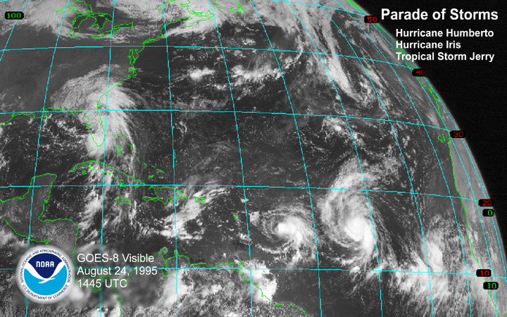
to the west, whose outflow intercepted with Humberto's outflow somewhat. Early on August 24, Humberto strengthened into a Category 2 hurricane, finally forming a well-defined eye, as it slowed down as it entered a Fujiwhara interaction with Iris. That afternoon, while still moving west-northwest, Humberto reached its peak intensity of 110 mph (175 km/h), just under Category 3 intensity.
The Fujiwhara interaction had a profound impact on the track of Humberto, which made a quick turn to the northwest, and then to the north-northwest, early on August 25. The interaction came to an end that afternoon as Humberto completed the northerly turn, while remaining a Category 2 hurricane in the tropical waters of the central Atlantic. It began to gradually weaken on August 26 due to an increase in southwesterly shear from a nearby upper-level low as it maintained a north-northwest track. The slow weakening trend continued into August 27 as the eye became intermittent in the moderate-shear environment, which was once again impacted by the outflow of Iris to the southwest. That evening, it dropped to a minimal hurricane with 75 mph (120 km/h) winds, which was later confirmed to have been the low point. Operationally, Humberto was downgraded to a tropical storm for a while on August 28, which was later confirmed to have been underestimated. As it tracked away from Iris and into a more open environment, it turned more to the north-northeast and slowly re-intensified again on August 29. Its movement was now affected by an incoming mid-latitude trough
that turned Humberto northeast early on August 30. Humberto reached its second intensity peak of 90 mph (145 km/h) at that time.
However, cooler waters eventually caught up to Humberto and it began to weaken once again early on August 31 as it tracked into the north Atlantic. That afternoon, Humberto weakened to a tropical storm as its circulation became embedded into a circulation of a nearby extratropical low in a high-shear environment. It continued to weaken that evening, and early on September 1, the tropical storm was absorbed by the larger system.
s came in contact with Humberto while it roamed the open waters. The strongest winds came from call sign DVRUK4, which reported peak winds of 70 mph (112 km/h) in the central Atlantic on August 30. Three other ships reported tropical storm-force winds.
 Humberto was the second of four tropical waves in quick succession in the tropical Atlantic that all eventually became tropical storms or hurricanes; it was preceded by the wave that became Iris, and followed by the waves that became Karen and Luis
. It was also the first of three tropical cyclones to form within a 24-hour period on August 21 and 22; Iris formed 12 hours later and Jerry formed 18 hours later. It was also the first of five named storms to form within a seven-day period; Karen formed on August 26 and Luis on August 27.
Tropical cyclone
A tropical cyclone is a storm system characterized by a large low-pressure center and numerous thunderstorms that produce strong winds and heavy rain. Tropical cyclones strengthen when water evaporated from the ocean is released as the saturated air rises, resulting in condensation of water vapor...
and fourth hurricane of the busy 1995 Atlantic hurricane season
1995 Atlantic hurricane season
The 1995 Atlantic hurricane season was the third most active Atlantic hurricane season on record. It officially began on June 1, 1995, and lasted until November 30, 1995. These dates conventionally delimit the period of each year when most tropical cyclones form in the north Atlantic ocean...
. This was the first time that the name "Humberto" was used as it replaced Hugo
Hurricane Hugo
Hurricane Hugo was a classical, destructive and rare Cape Verde-type hurricane which struck the Caribbean islands of Guadeloupe, Montserrat, St. Croix, Puerto Rico and the USA mainland in South Carolina as a Category 4 hurricane during September of the 1989 Atlantic hurricane season...
(it was retired in 1989). It was a Cape Verde-type hurricane
Cape Verde-type hurricane
A Cape Verde-type hurricane is an Atlantic hurricane that develops near the Cape Verde islands, off the west coast of Africa. The average hurricane season has about two Cape Verde-type hurricanes, which are usually the largest and most intense storms of the season because they often have plenty of...
that never approached land as it tracked across the central Atlantic Ocean
Atlantic Ocean
The Atlantic Ocean is the second-largest of the world's oceanic divisions. With a total area of about , it covers approximately 20% of the Earth's surface and about 26% of its water surface area...
.
The storm developed west of the Cape Verde
Cape Verde
The Republic of Cape Verde is an island country, spanning an archipelago of 10 islands located in the central Atlantic Ocean, 570 kilometres off the coast of Western Africa...
islands on August 21 and was upgraded to a tropical storm on August 22 and a hurricane on August 23. For the first several days, it followed the wave that became Iris until a Fujiwhara interaction took place about midway between Cape Verde and the Lesser Antilles
Lesser Antilles
The Lesser Antilles are a long, partly volcanic island arc in the Western Hemisphere. Most of its islands form the eastern boundary of the Caribbean Sea with the Atlantic Ocean, with the remainder located in the southern Caribbean just north of South America...
on August 25. Humberto peaked as a strong Category 2
Saffir-Simpson Hurricane Scale
The Saffir–Simpson Hurricane Scale , or the Saffir–Simpson Hurricane Wind Scale , classifies hurricanes — Western Hemisphere tropical cyclones that exceed the intensities of tropical depressions and tropical storms — into five categories distinguished by the intensities of their sustained winds...
hurricane and remained a hurricane until just before being absorbed by an extratropical cyclone
Extratropical cyclone
Extratropical cyclones, sometimes called mid-latitude cyclones or wave cyclones, are a group of cyclones defined as synoptic scale low pressure weather systems that occur in the middle latitudes of the Earth having neither tropical nor polar characteristics, and are connected with fronts and...
on September 1.
Meteorological history
The system originated out of one of several powerful tropical waveTropical wave
Tropical waves, easterly waves, or tropical easterly waves, also known as African easterly waves in the Atlantic region, are a type of atmospheric trough, an elongated area of relatively low air pressure, oriented north to south, which move from east to west across the tropics causing areas of...
s that moved off the west coast of Africa
Africa
Africa is the world's second largest and second most populous continent, after Asia. At about 30.2 million km² including adjacent islands, it covers 6% of the Earth's total surface area and 20.4% of the total land area...
in the second half of August. When the wave came off the African coast, it already had a cyclonic rotation, although it was fairly disorganized. As the wave moved westward into open waters, it developed rapidly. Late on August 21, it had developed a low-level circulation and was declared Tropical Depression Nine. The system quickly organized itself and was quickly upgraded to Tropical Storm Humberto early on August 22. Beginning on a west-northwest track, it was clear from the outset that Humberto would not affect land, due to a weakness in the subtropical ridge
Subtropical ridge
The subtropical ridge is a significant belt of high pressure situated around the latitudes of 30°N in the Northern Hemisphere and 30°S in the Southern Hemisphere. It is characterized by mostly calm winds, which acts to reduce air quality under its axis by causing fog overnight, and haze during...
to the north which would eventually turn the storm northward. An impressive outflow pattern and solid banding quickly formed in a very favorable environment with warm sea surface temperatures and low wind shear
Wind shear
Wind shear, sometimes referred to as windshear or wind gradient, is a difference in wind speed and direction over a relatively short distance in the atmosphere...
. Humberto quickly developed and intensified into a high-end tropical storm on the afternoon and evening of August 22. Early on August 23, the storm was upgraded to Hurricane Humberto.
Humberto continued to intensify on the morning of the 23rd as the central dense overcast became well defined, despite the lack of a well-defined eye
Eye (cyclone)
The eye is a region of mostly calm weather found at the center of strong tropical cyclones. The eye of a storm is a roughly circular area and typically 30–65 km in diameter. It is surrounded by the eyewall, a ring of towering thunderstorms where the second most severe weather of a cyclone...
feature. However, the intensification was slowed somewhat by the presence of Iris
Hurricane Iris (1995)
Hurricane Iris was the ninth named tropical cyclone and fifth hurricane of an active 1995 Atlantic hurricane season. Iris was one of four storms to form nearly simultaneously in the Atlantic during the 1995 season. Forming on August 22, Iris slowly drifted across the Leeward Islands as a tropical...
to the west, whose outflow intercepted with Humberto's outflow somewhat. Early on August 24, Humberto strengthened into a Category 2 hurricane, finally forming a well-defined eye, as it slowed down as it entered a Fujiwhara interaction with Iris. That afternoon, while still moving west-northwest, Humberto reached its peak intensity of 110 mph (175 km/h), just under Category 3 intensity.
The Fujiwhara interaction had a profound impact on the track of Humberto, which made a quick turn to the northwest, and then to the north-northwest, early on August 25. The interaction came to an end that afternoon as Humberto completed the northerly turn, while remaining a Category 2 hurricane in the tropical waters of the central Atlantic. It began to gradually weaken on August 26 due to an increase in southwesterly shear from a nearby upper-level low as it maintained a north-northwest track. The slow weakening trend continued into August 27 as the eye became intermittent in the moderate-shear environment, which was once again impacted by the outflow of Iris to the southwest. That evening, it dropped to a minimal hurricane with 75 mph (120 km/h) winds, which was later confirmed to have been the low point. Operationally, Humberto was downgraded to a tropical storm for a while on August 28, which was later confirmed to have been underestimated. As it tracked away from Iris and into a more open environment, it turned more to the north-northeast and slowly re-intensified again on August 29. Its movement was now affected by an incoming mid-latitude trough
Trough (meteorology)
A trough is an elongated region of relatively low atmospheric pressure, often associated with fronts.Unlike fronts, there is not a universal symbol for a trough on a weather chart. The weather charts in some countries or regions mark troughs by a line. In the United States, a trough may be marked...
that turned Humberto northeast early on August 30. Humberto reached its second intensity peak of 90 mph (145 km/h) at that time.
However, cooler waters eventually caught up to Humberto and it began to weaken once again early on August 31 as it tracked into the north Atlantic. That afternoon, Humberto weakened to a tropical storm as its circulation became embedded into a circulation of a nearby extratropical low in a high-shear environment. It continued to weaken that evening, and early on September 1, the tropical storm was absorbed by the larger system.
Impact, naming, and records
Humberto remained in the open Atlantic, and no damage or fatalities were reported. Several shipShip
Since the end of the age of sail a ship has been any large buoyant marine vessel. Ships are generally distinguished from boats based on size and cargo or passenger capacity. Ships are used on lakes, seas, and rivers for a variety of activities, such as the transport of people or goods, fishing,...
s came in contact with Humberto while it roamed the open waters. The strongest winds came from call sign DVRUK4, which reported peak winds of 70 mph (112 km/h) in the central Atlantic on August 30. Three other ships reported tropical storm-force winds.
Hurricane Luis
Hurricane Luis was one of the deadliest and most destructive hurricanes of the 1995 Atlantic hurricane season, with maximum sustained winds of 140 mph . The storm was the twelfth tropical storm, sixth hurricane, and second major hurricane of the season...
. It was also the first of three tropical cyclones to form within a 24-hour period on August 21 and 22; Iris formed 12 hours later and Jerry formed 18 hours later. It was also the first of five named storms to form within a seven-day period; Karen formed on August 26 and Luis on August 27.
See also
- Other storms of the same name
- Timeline of the 1995 Atlantic hurricane seasonTimeline of the 1995 Atlantic hurricane seasonThis timeline documents all the storm formations, strengthening, weakening, landfalls, extratropical transitions, as well as dissipation during the 1995 Atlantic hurricane season. The season officially began on June 1, 1995, and ended on November 30, and no storms formed off-season...
External links
- NHC's Preliminary Report on Hurricane Humberto