

List of bridges in the United States by height
Encyclopedia
Bridge
A bridge is a structure built to span physical obstacles such as a body of water, valley, or road, for the purpose of providing passage over the obstacle...
s in the United States sorted by their height over land or water. "Height" refers to the distance from the bridge deck to the lowest point in the land or water below.
Bridges
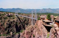
| Name | Height feet | Spans | Completed | Royal Gorge Bridge Royal Gorge Bridge The Royal Gorge Bridge is a tourist attraction near Cañon City, Colorado, within a theme park. The bridge deck hangs above the Arkansas River, and held the record of highest bridge in the world from 1929 until 2003, when it was surpassed by the Beipanjiang River 2003 Bridge in China. It is a... | 1,053 | Arkansas River Arkansas River The Arkansas River is a major tributary of the Mississippi River. The Arkansas generally flows to the east and southeast as it traverses the U.S. states of Colorado, Kansas, Oklahoma, and Arkansas. The river's initial basin starts in the Western United States in Colorado, specifically the Arkansas... |
1929 | Colorado Colorado Colorado is a U.S. state that encompasses much of the Rocky Mountains as well as the northeastern portion of the Colorado Plateau and the western edge of the Great Plains... |
|---|---|---|---|---|---|---|---|---|
| Mike O'Callaghan – Pat Tillman Memorial Bridge | 890 | Colorado River Colorado River The Colorado River , is a river in the Southwestern United States and northwestern Mexico, approximately long, draining a part of the arid regions on the western slope of the Rocky Mountains. The watershed of the Colorado River covers in parts of seven U.S. states and two Mexican states... |
2010 | Arizona Arizona Arizona ; is a state located in the southwestern region of the United States. It is also part of the western United States and the mountain west. The capital and largest city is Phoenix... / Nevada Nevada Nevada is a state in the western, mountain west, and southwestern regions of the United States. With an area of and a population of about 2.7 million, it is the 7th-largest and 35th-most populous state. Over two-thirds of Nevada's people live in the Las Vegas metropolitan area, which contains its... |
||||
| New River Gorge Bridge New River Gorge Bridge The New River Gorge Bridge is a steel arch bridge long over the New River Gorge near Fayetteville, West Virginia, in the Appalachian Mountains of the eastern United States. With an arch long, the New River Gorge Bridge was for many years the world's longest arch bridge; it is now the third... |
876 | New River | 1977 | West Virginia West Virginia West Virginia is a state in the Appalachian and Southeastern regions of the United States, bordered by Virginia to the southeast, Kentucky to the southwest, Ohio to the northwest, Pennsylvania to the northeast and Maryland to the east... |
||||
| Foresthill Bridge Foresthill Bridge The Foresthill Bridge over the North Fork of the American River is the highest bridge in the U.S. state of California. It is sometimes referred to as the Auburn-Foresthill Bridge or the Auburn Bridge.... |
730 | American River American River The American River is a California watercourse noted as the site of Sutter's Mill, northwest of Placerville, California, where gold was found in 1848, leading to the California Gold Rush... |
1973 | California California California is a state located on the West Coast of the United States. It is by far the most populous U.S. state, and the third-largest by land area... |
||||
| Glade Creek Bridge | 700 | Glade Creek Glade Creek (New River) Glade Creek is a major tributary of the New River in Raleigh County, West Virginia. Glade Creek lies within the largest side valley off New River in the New River Gorge National River area.-Source:... |
1988 | West Virginia West Virginia West Virginia is a state in the Appalachian and Southeastern regions of the United States, bordered by Virginia to the southeast, Kentucky to the southwest, Ohio to the northwest, Pennsylvania to the northeast and Maryland to the east... |
||||
| Glen Canyon Bridge Glen Canyon Dam Glen Canyon Dam is a concrete arch dam on the Colorado River in northern Arizona in the United States, just north of Page. The dam was built to provide hydroelectricity and flow regulation from the upper Colorado River Basin to the lower. Its reservoir is called Lake Powell, and is the second... |
700 | Colorado River Colorado River The Colorado River , is a river in the Southwestern United States and northwestern Mexico, approximately long, draining a part of the arid regions on the western slope of the Rocky Mountains. The watershed of the Colorado River covers in parts of seven U.S. states and two Mexican states... |
1964 | Arizona Arizona Arizona ; is a state located in the southwestern region of the United States. It is also part of the western United States and the mountain west. The capital and largest city is Phoenix... |
||||
| Rio Grande Gorge Bridge Rio Grande Gorge Bridge The Rio Grande Gorge Bridge, locally known as the "Gorge Bridge," is a cantilever truss bridge across the Rio Grande Gorge northwest of Taos, New Mexico, United States... |
660 | Rio Grande Rio Grande The Rio Grande is a river that flows from southwestern Colorado in the United States to the Gulf of Mexico. Along the way it forms part of the Mexico – United States border. Its length varies as its course changes... |
1965 | New Mexico New Mexico New Mexico is a state located in the southwest and western regions of the United States. New Mexico is also usually considered one of the Mountain States. With a population density of 16 per square mile, New Mexico is the sixth-most sparsely inhabited U.S... |
||||
| Perrine Bridge Perrine Bridge The I. B. Perrine Bridge at Twin Falls, Idaho, United States is a truss arch four-lane bridge carrying U.S. Highway 93 over the Snake River Canyon. Perrine Bridge is approximately long and above the Snake River... |
486 | Snake River Snake River The Snake is a major river of the greater Pacific Northwest in the United States. At long, it is the largest tributary of the Columbia River, the largest North American river that empties into the Pacific Ocean... |
1974 | Idaho Idaho Idaho is a state in the Rocky Mountain area of the United States. The state's largest city and capital is Boise. Residents are called "Idahoans". Idaho was admitted to the Union on July 3, 1890, as the 43rd state.... |
||||
| Navajo Bridge Navajo Bridge Navajo Bridge crosses the Colorado River's Marble Canyon near Lee's Ferry in the US state of Arizona. Apart from the Glen Canyon Bridge a few miles upstream at Page, Arizona, it is the only roadway crossing of the river and the Grand Canyon for nearly... s |
470 | Colorado River Colorado River The Colorado River , is a river in the Southwestern United States and northwestern Mexico, approximately long, draining a part of the arid regions on the western slope of the Rocky Mountains. The watershed of the Colorado River covers in parts of seven U.S. states and two Mexican states... |
1929/1995 | Arizona Arizona Arizona ; is a state located in the southwestern region of the United States. It is also part of the western United States and the mountain west. The capital and largest city is Phoenix... |
||||
| Pine Valley Creek Bridge Pine Valley Creek Bridge The Pine Valley Creek Bridge, also known as Nello Irwin Greer Memorial Bridge, is a reinforced concrete box girder bridge in California, built in 1974 as part of the Interstate 8 freeway system. At the time of its construction, it was the first bridge constructed in the United States using the... |
450 | Pine Valley Creek | 1974 | California California California is a state located on the West Coast of the United States. It is by far the most populous U.S. state, and the third-largest by land area... |
||||
| Moyie River Bridge | 424 | Moyie River Moyie River The Moyie River is a tributary of the Kootenai River in the U.S. state of Idaho and the Canadian province of British Columbia. The Moyie River is part of the Columbia River basin, being a tributary of the Kootenay River, which is tributary to the Columbia River.-Course:The Moyie River originates... |
1965 | Idaho Idaho Idaho is a state in the Rocky Mountain area of the United States. The state's largest city and capital is Boise. Residents are called "Idahoans". Idaho was admitted to the Union on July 3, 1890, as the 43rd state.... |
||||
| High Steel Bridge High Steel Bridge High Steel Bridge is a truss arch bridge that spans the south fork of the Skokomish River in Mason County, Washington. It was built in 1929 by Simpson Logging Company as part of a logging railroad.... |
420 | Skokomish River Skokomish River The Skokomish River is a river in Mason County, Washington, United States. It is the largest river flowing into Hood Canal, an arm of Puget Sound. From its source at the confluence of the North and South Forks the main stem Skokomish River is approximately long. The longer South Fork Skokomish... |
1929 | Washington | ||||
| Cold Spring Canyon Bridge | 420 | Cold Spring Canyon | 1964 | California California California is a state located on the West Coast of the United States. It is by far the most populous U.S. state, and the third-largest by land area... |
||||
| Lewiston-Queenston Bridge Lewiston-Queenston Bridge The Lewiston–Queenston Bridge is an arch bridge that crosses the Niagara River gorge just south of the Niagara Escarpment. The bridge was officially opened on November 1, 1962. It is an international bridge between the United States and Canada. It connects Interstate 190 in the town of Lewiston,... |
370 | Niagara River Niagara River The Niagara River flows north from Lake Erie to Lake Ontario. It forms part of the border between the Province of Ontario in Canada and New York State in the United States. There are differing theories as to the origin of the name of the river... |
1962 | New York New York New York is a state in the Northeastern region of the United States. It is the nation's third most populous state. New York is bordered by New Jersey and Pennsylvania to the south, and by Connecticut, Massachusetts and Vermont to the east... |
||||
| Hoffstadt Creek Bridge | 370 | Hoffstadt Creek | 1994 | Washington | ||||
| Thomas Creek Bridge Thomas Creek Bridge Thomas Creek Bridge crosses Thomas Creek in Curry County, Oregon, U.S. It is on US Route 101 and lies within the boundaries of Samuel H. Boardman State Scenic Corridor.... |
345 | Thomas Creek | 1961 | Oregon Oregon Oregon is a state in the Pacific Northwest region of the United States. It is located on the Pacific coast, with Washington to the north, California to the south, Nevada on the southeast and Idaho to the east. The Columbia and Snake rivers delineate much of Oregon's northern and eastern... |
||||
| Fred G. Redmon Bridge Fred G. Redmon Bridge The Fred G. Redmon Bridge, also known as the Selah Creek Bridge, is a twin arch bridge that spans Selah Creek near Selah, Washington.-Construction:... |
325 | Selah Creek, a Yakima River Yakima River The Yakima River is a tributary of the Columbia River in south central and eastern Washington State, named for the indigenous Yakama people. The length of the river from headwaters to mouth is , with an average drop of .-Course:... tributary Tributary A tributary or affluent is a stream or river that flows into a main stem river or a lake. A tributary does not flow directly into a sea or ocean... |
1971 | Washington | ||||
| Rex T. Barber Veterans Memorial Bridge Rex T. Barber Veterans Memorial Bridge The Rex T. Barber Veterans Memorial Bridge is a concrete arch bridge that spans the Crooked River gorge in Jefferson County, Oregon. It was designed by T. Y. Lin International and was completed in 2000 to replace the Crooked River High Bridge. The older bridge was built in 1926 and was not wide... |
300 | Crooked River Crooked River (Oregon) The Crooked River is a tributary, long, of the Deschutes River in the U.S. state of Oregon. The river begins at the confluence of South Fork Crooked River and Beaver Creek. Of the two tributaries, the South Fork Crooked River is the larger and is sometimes considered part of the Crooked River proper... |
2000 | Oregon Oregon Oregon is a state in the Pacific Northwest region of the United States. It is located on the Pacific coast, with Washington to the north, California to the south, Nevada on the southeast and Idaho to the east. The Columbia and Snake rivers delineate much of Oregon's northern and eastern... |
||||
| Hurricane Gulch Bridge | 296 | Chulitna River Chulitna River The Chulitna River is the name of two rivers in Alaska:*Chulitna River , a 70 mile long tributary of the Susitna River.*Chulitna River , a 90 mile long tributary of Lake Clark.... |
1921 | Alaska Alaska Alaska is the largest state in the United States by area. It is situated in the northwest extremity of the North American continent, with Canada to the east, the Arctic Ocean to the north, and the Pacific Ocean to the west and south, with Russia further west across the Bering Strait... |
||||
| Crooked River High Bridge Crooked River High Bridge The Crooked River High Bridge is a steel arch bridge that spans the Crooked River gorge in Jefferson County, Oregon. The bridge was designed by Conde McCullough and was completed in 1926. Shortly after its completion, Oregon State Highway Division created the Peter Skene Ogden Park just to the... |
295 | Crooked River Crooked River (Oregon) The Crooked River is a tributary, long, of the Deschutes River in the U.S. state of Oregon. The river begins at the confluence of South Fork Crooked River and Beaver Creek. Of the two tributaries, the South Fork Crooked River is the larger and is sometimes considered part of the Crooked River proper... |
1926 | Oregon Oregon Oregon is a state in the Pacific Northwest region of the United States. It is located on the Pacific coast, with Washington to the north, California to the south, Nevada on the southeast and Idaho to the east. The Columbia and Snake rivers delineate much of Oregon's northern and eastern... |
||||
| Pecos River High Bridge Pecos River High Bridge The Pecos River High Bridge carries the Southern Pacific Railroad across the Pecos River gorge and is the second high-level crossing on this site. The first, designed by SP chief engineer Julius Kruttschnitt, was built by the Phoenix Bridge Company and completed in 1892... |
273 | Pecos River Pecos River The headwaters of the Pecos River are located north of Pecos, New Mexico, United States, at an elevation of over 12,000 feet on the western slope of the Sangre de Cristo mountain range in Mora County. The river flows for through the eastern portion of that state and neighboring Texas before it... |
1944 | Texas Texas Texas is the second largest U.S. state by both area and population, and the largest state by area in the contiguous United States.The name, based on the Caddo word "Tejas" meaning "friends" or "allies", was applied by the Spanish to the Caddo themselves and to the region of their settlement in... |
||||
| Emlenton Bridge Emlenton Bridge The Emlenton Bridge is a steel deck truss bridge that spans the Allegheny River just south of the town of Emlenton, Pennsylvania at approximately mile marker 44.4 on I-80... |
270 | Allegheny River Allegheny River The Allegheny River is a principal tributary of the Ohio River; it is located in the Eastern United States. The Allegheny River joins with the Monongahela River to form the Ohio River at the "Point" of Point State Park in Downtown Pittsburgh, Pennsylvania... |
1968 | Pennsylvania Pennsylvania The Commonwealth of Pennsylvania is a U.S. state that is located in the Northeastern and Mid-Atlantic regions of the United States. The state borders Delaware and Maryland to the south, West Virginia to the southwest, Ohio to the west, New York and Ontario, Canada, to the north, and New Jersey to... |
||||
| South Fork Eel River Bridge Confusion Hill Bridges The Confusion Hill Bridges are a pair of high bridges carrying two lanes of U.S. Highway 101 over the South Fork Eel River in Mendocino County in the U.S. state of California... |
265 | South Fork Eel River Eel River (California) The Eel River is a major river system of the northern Pacific coast of the U.S. state of California. Approximately 200 miles long, it drains a rugged area in the California Coast Ranges between the Sacramento Valley and the ocean. For most of its course, the river flows northwest, parallel to the... |
2009 | California California California is a state located on the West Coast of the United States. It is by far the most populous U.S. state, and the third-largest by land area... |
||||
| Bixby Creek Bridge | 260 | Bixby Creek | 1932 | California California California is a state located on the West Coast of the United States. It is by far the most populous U.S. state, and the third-largest by land area... |
||||
| George Westinghouse Bridge George Westinghouse Bridge George Westinghouse Memorial Bridge in East Pittsburgh, Pennsylvania carries U.S. Route 30, The Lincoln Highway, over the Turtle Creek Valley where it joins the Monongahela River Valley east of Pittsburgh.... |
240 | Turtle Creek Turtle Creek (Pennsylvania) Turtle Creek is a tributary of the Monongahela River in Allegheny and Westmoreland counties in the U.S. state of Pennsylvania. At its juncture with the Monongahela is Braddock, Pennsylvania, where the Battle of the Monongahela was fought in 1755... |
1932 | Pennsylvania Pennsylvania The Commonwealth of Pennsylvania is a U.S. state that is located in the Northeastern and Mid-Atlantic regions of the United States. The state borders Delaware and Maryland to the south, West Virginia to the southwest, Ohio to the west, New York and Ontario, Canada, to the north, and New Jersey to... |
||||
| Jeremiah Morrow Bridge Jeremiah Morrow Bridge The Jeremiah Morrow Bridge is a pair of parallel continuous truss bridges which span the Little Miami River gorge between Fort Ancient and Oregonia, Ohio. The bridges are named for Governor Jeremiah Morrow.... |
239 | Little Miami River Little Miami River The Little Miami River is a Class I tributary of the Ohio River that flows through five counties in southwestern Ohio in the United States. The Little Miami joins the Ohio River east of Cincinnati. It forms parts of the borders between Hamilton and Clermont counties and between Hamilton and Warren... |
1965 | Ohio Ohio Ohio is a Midwestern state in the United States. The 34th largest state by area in the U.S.,it is the 7th‑most populous with over 11.5 million residents, containing several major American cities and seven metropolitan areas with populations of 500,000 or more.The state's capital is Columbus... |
||||
| Verrazano-Narrows Bridge Verrazano-Narrows Bridge The Verrazano-Narrows Bridge is a double-decked suspension bridge that connects the boroughs of Staten Island and Brooklyn in New York City at the Narrows, the reach connecting the relatively protected upper bay with the larger lower bay.... |
226 | The Narrows The Narrows The Narrows is the tidal strait separating the boroughs of Staten Island and Brooklyn in New York City. It connects the Upper New York Bay and Lower New York Bay and forms the principal channel by which the Hudson River empties into the Atlantic Ocean... |
1964 | New York New York New York is a state in the Northeastern region of the United States. It is the nation's third most populous state. New York is bordered by New Jersey and Pennsylvania to the south, and by Connecticut, Massachusetts and Vermont to the east... |
||||
| Whirlpool Rapids Bridge Whirlpool Rapids Bridge The Whirlpool Rapids Bridge, commonly called the Whirlpool Bridge, and until 1937, known as the Lower Steel Arch Bridge, is a spandrel braced, riveted, two-hinged arch bridge. It crosses the international border between Canada and the United States, connecting the commercial downtown districts of... |
225 | Niagara River Niagara River The Niagara River flows north from Lake Erie to Lake Ontario. It forms part of the border between the Province of Ontario in Canada and New York State in the United States. There are differing theories as to the origin of the name of the river... |
1897 | New York New York New York is a state in the Northeastern region of the United States. It is the nation's third most populous state. New York is bordered by New Jersey and Pennsylvania to the south, and by Connecticut, Massachusetts and Vermont to the east... |
||||
| Peter Guice Memorial Bridge Peter Guice Memorial Bridge The Peter Guice Memorial Bridge consists of dual two-lane bridges carrying I-26 across the Green River in Western North Carolina. Surpassed only by the Emlenton Bridge in Pennsylvania and the Glade Creek Bridge in West Virginia, it is the third-highest bridge carrying an Interstate Highway in the... |
225 | Green River Green River (North Carolina) The Green River in North Carolina, United States, is perhaps best known as one of the extreme whitewater kayaking challenges in North America that is run on a regular basis.... |
1972 | North Carolina North Carolina North Carolina is a state located in the southeastern United States. The state borders South Carolina and Georgia to the south, Tennessee to the west and Virginia to the north. North Carolina contains 100 counties. Its capital is Raleigh, and its largest city is Charlotte... |
||||
| Golden Gate Bridge Golden Gate Bridge The Golden Gate Bridge is a suspension bridge spanning the Golden Gate, the opening of the San Francisco Bay into the Pacific Ocean. As part of both U.S. Route 101 and California State Route 1, the structure links the city of San Francisco, on the northern tip of the San Francisco Peninsula, to... |
220 | San Francisco Bay San Francisco Bay San Francisco Bay is a shallow, productive estuary through which water draining from approximately forty percent of California, flowing in the Sacramento and San Joaquin rivers from the Sierra Nevada mountains, enters the Pacific Ocean... |
1937 | California California California is a state located on the West Coast of the United States. It is by far the most populous U.S. state, and the third-largest by land area... |
||||
| San Francisco – Oakland Bay Bridge | 220 | San Francisco Bay San Francisco Bay San Francisco Bay is a shallow, productive estuary through which water draining from approximately forty percent of California, flowing in the Sacramento and San Joaquin rivers from the Sierra Nevada mountains, enters the Pacific Ocean... |
1936 | California California California is a state located on the West Coast of the United States. It is by far the most populous U.S. state, and the third-largest by land area... |
||||
| Laurel Creek Gorge Bridge Laurel Creek Gorge Bridge The Laurel Creek Gorge Bridge is a continuous steel Plate girder bridge that spans Laurel Creek on Interstate 26 between Asheville, North Carolina and Johnson City, Tennessee. It is the second tallest bridge in North Carolina at a height of 220 ft. Construction of the bridge was finished in 2002... |
220 | Big Laurel Creek | 2002 | North Carolina North Carolina North Carolina is a state located in the southeastern United States. The state borders South Carolina and Georgia to the south, Tennessee to the west and Virginia to the north. North Carolina contains 100 counties. Its capital is Raleigh, and its largest city is Charlotte... |
||||
| George Washington Bridge George Washington Bridge The George Washington Bridge is a suspension bridge spanning the Hudson River, connecting the Washington Heights neighborhood in the borough of Manhattan in New York City to Fort Lee, Bergen County, New Jersey. Interstate 95 and U.S. Route 1/9 cross the river via the bridge. U.S... |
212 | Hudson River Hudson River The Hudson is a river that flows from north to south through eastern New York. The highest official source is at Lake Tear of the Clouds, on the slopes of Mount Marcy in the Adirondack Mountains. The river itself officially begins in Henderson Lake in Newcomb, New York... |
1931 | New York New York New York is a state in the Northeastern region of the United States. It is the nation's third most populous state. New York is bordered by New Jersey and Pennsylvania to the south, and by Connecticut, Massachusetts and Vermont to the east... /New Jersey New Jersey New Jersey is a state in the Northeastern and Middle Atlantic regions of the United States. , its population was 8,791,894. It is bordered on the north and east by the state of New York, on the southeast and south by the Atlantic Ocean, on the west by Pennsylvania and on the southwest by Delaware... |
||||
| Valley View Bridge Valley View Bridge The Valley View Bridge is a pair of steel multi-stringer highway girder bridges that carry I-480 over the Cuyahoga River valley in Valley View and Independence, Ohio. They are high and long.-History:... |
212 | Cuyahoga Valley | 1978 | Ohio Ohio Ohio is a Midwestern state in the United States. The 34th largest state by area in the U.S.,it is the 7th‑most populous with over 11.5 million residents, containing several major American cities and seven metropolitan areas with populations of 500,000 or more.The state's capital is Columbus... |
||||
| Lewis and Clark Bridge | 210 | Columbia River Columbia River The Columbia River is the largest river in the Pacific Northwest region of North America. The river rises in the Rocky Mountains of British Columbia, Canada, flows northwest and then south into the U.S. state of Washington, then turns west to form most of the border between Washington and the state... |
1930 | Oregon Oregon Oregon is a state in the Pacific Northwest region of the United States. It is located on the Pacific coast, with Washington to the north, California to the south, Nevada on the southeast and Idaho to the east. The Columbia and Snake rivers delineate much of Oregon's northern and eastern... /Washington |
||||
| Claiborne Pell Newport Bridge Claiborne Pell Newport Bridge The Claiborne Pell Bridge, commonly known as the Newport Bridge, is a suspension bridge operated by the Rhode Island Turnpike and Bridge Authority that spans the East Passage of the Narragansett Bay in Rhode Island , connecting the City of Newport on Aquidneck Island and the Town of Jamestown on... |
206 | Narragansett Bay Narragansett Bay Narragansett Bay is a bay and estuary on the north side of Rhode Island Sound. Covering 147 mi2 , the Bay forms New England's largest estuary, which functions as an expansive natural harbor, and includes a small archipelago... |
1969 | Rhode Island Rhode Island The state of Rhode Island and Providence Plantations, more commonly referred to as Rhode Island , is a state in the New England region of the United States. It is the smallest U.S. state by area... |
||||
| Astoria-Megler Bridge Astoria-Megler Bridge The Astoria–Megler Bridge is a steel girder continuous truss bridge that spans the Columbia River between Astoria, Oregon and Point Ellice near Megler, Washington, in the United States. The span is from the mouth of the river, and was the last segment of U.S. Route 101 between Olympia, Washington... |
205 | Columbia River Columbia River The Columbia River is the largest river in the Pacific Northwest region of North America. The river rises in the Rocky Mountains of British Columbia, Canada, flows northwest and then south into the U.S. state of Washington, then turns west to form most of the border between Washington and the state... |
1966 | Oregon Oregon Oregon is a state in the Pacific Northwest region of the United States. It is located on the Pacific coast, with Washington to the north, California to the south, Nevada on the southeast and Idaho to the east. The Columbia and Snake rivers delineate much of Oregon's northern and eastern... /Washington |
||||
| St. Johns Bridge St. Johns Bridge The St. Johns Bridge is a steel suspension bridge that spans the Willamette River in Portland, Oregon, USA, between the St. Johns neighborhood and the northwest industrial area around Linnton. It is the only suspension bridge in the Willamette Valley and one of three public highway suspension... |
205 | Willamette River Willamette River The Willamette River is a major tributary of the Columbia River, accounting for 12 to 15 percent of the Columbia's flow. The Willamette's main stem is long, lying entirely in northwestern Oregon in the United States... |
1931 | Oregon Oregon Oregon is a state in the Pacific Northwest region of the United States. It is located on the Pacific coast, with Washington to the north, California to the south, Nevada on the southeast and Idaho to the east. The Columbia and Snake rivers delineate much of Oregon's northern and eastern... |
||||
| Rainbow Bridge Rainbow Bridge (Niagara Falls) The Rainbow Bridge at Niagara Falls is an international steel arch bridge across the Niagara River gorge, and is a world-famous tourist site. It connects the cities of Niagara Falls, New York, United States , and Niagara Falls, Ontario, Canada .-Construction:The Rainbow Bridge was built near the... |
202 | Niagara River Niagara River The Niagara River flows north from Lake Erie to Lake Ontario. It forms part of the border between the Province of Ontario in Canada and New York State in the United States. There are differing theories as to the origin of the name of the river... |
1941 | New York New York New York is a state in the Northeastern region of the United States. It is the nation's third most populous state. New York is bordered by New Jersey and Pennsylvania to the south, and by Connecticut, Massachusetts and Vermont to the east... |
||||
| Hite Crossing Bridge Hite Crossing Bridge The Hite Crossing Bridge is an arch bridge which carries Utah State Route 95 across the Colorado River northwest of Blanding, Utah, United States. The bridge informally marks the upstream limit of Lake Powell and the end of Cataract Canyon of the Colorado River, but when the lake is at normal... |
200 | Colorado River Colorado River The Colorado River , is a river in the Southwestern United States and northwestern Mexico, approximately long, draining a part of the arid regions on the western slope of the Rocky Mountains. The watershed of the Colorado River covers in parts of seven U.S. states and two Mexican states... |
1966 | Utah Utah Utah is a state in the Western United States. It was the 45th state to join the Union, on January 4, 1896. Approximately 80% of Utah's 2,763,885 people live along the Wasatch Front, centering on Salt Lake City. This leaves vast expanses of the state nearly uninhabited, making the population the... |
||||
| Tacoma Narrows Bridge Tacoma Narrows Bridge The Tacoma Narrows Bridge is a pair of twin suspension bridges in the U.S. state of Washington, which carry State Route 16 across the Tacoma Narrows strait of Puget Sound between Tacoma and the Kitsap Peninsula... |
200 | Puget Sound Puget Sound Puget Sound is a sound in the U.S. state of Washington. It is a complex estuarine system of interconnected marine waterways and basins, with one major and one minor connection to the Strait of Juan de Fuca and the Pacific Ocean — Admiralty Inlet being the major connection and... |
1950/2007 | Washington | ||||
| San Diego-Coronado Bridge San Diego-Coronado Bridge The San Diego-Coronado Bridge, locally referred to as the Coronado Bridge, is a "prestressed concrete/steel" girder bridge, crossing over San Diego Bay in the United States, linking San Diego with Coronado, California... |
200 | San Diego Bay San Diego Bay San Diego Bay is a natural harbor and deepwater port adjacent to San Diego, California. It is 12 mi/19 km long, 1 mi/1.6 km–3 mi/4.8 km wide... |
1959 | California California California is a state located on the West Coast of the United States. It is by far the most populous U.S. state, and the third-largest by land area... |
||||
| Mackinac Bridge Mackinac Bridge The Mackinac Bridge is a suspension bridge spanning the Straits of Mackinac to connect the non-contiguous Upper and Lower peninsulas of the U.S. state of Michigan. Opened in 1957, the bridge is the third longest in total suspension in the world and the longest suspension bridge between anchorages... |
199 | Straits of Mackinac Straits of Mackinac The Straits of Mackinac is the strip of water that connects two of the Great Lakes, Lake Michigan and Lake Huron, and separates the Lower Peninsula of Michigan from the Upper Peninsula of Michigan. It is a shipping lane providing passage for raw materials and finished goods, connecting, for... |
1957 | Michigan Michigan Michigan is a U.S. state located in the Great Lakes Region of the United States of America. The name Michigan is the French form of the Ojibwa word mishigamaa, meaning "large water" or "large lake".... |
||||
| Sunshine Skyway | 197 | Tampa Bay Tampa Bay Tampa Bay is a large natural harbor and estuary along the Gulf of Mexico on the west central coast of Florida, comprising Hillsborough Bay, Old Tampa Bay, Middle Tampa Bay, and Lower Tampa Bay."Tampa Bay" is not the name of any municipality... |
1987 | Florida Florida Florida is a state in the southeastern United States, located on the nation's Atlantic and Gulf coasts. It is bordered to the west by the Gulf of Mexico, to the north by Alabama and Georgia and to the east by the Atlantic Ocean. With a population of 18,801,310 as measured by the 2010 census, it... |
||||
| Commodore Barry Bridge Commodore Barry Bridge The Commodore Barry Bridge is a cantilever bridge that spans the Delaware River from Chester, Pennsylvania to Bridgeport, in Logan Township, New Jersey, USA... |
192 | Delaware River Delaware River The Delaware River is a major river on the Atlantic coast of the United States.A Dutch expedition led by Henry Hudson in 1609 first mapped the river. The river was christened the South River in the New Netherland colony that followed, in contrast to the North River, as the Hudson River was then... |
1974 | Pennsylvania Pennsylvania The Commonwealth of Pennsylvania is a U.S. state that is located in the Northeastern and Mid-Atlantic regions of the United States. The state borders Delaware and Maryland to the south, West Virginia to the southwest, Ohio to the west, New York and Ontario, Canada, to the north, and New Jersey to... / New Jersey New Jersey New Jersey is a state in the Northeastern and Middle Atlantic regions of the United States. , its population was 8,791,894. It is bordered on the north and east by the state of New York, on the southeast and south by the Atlantic Ocean, on the west by Pennsylvania and on the southwest by Delaware... |
||||
| Hawk Falls Bridge (Pennsylvania Turnpike Pennsylvania Turnpike The Pennsylvania Turnpike is a toll highway system operated by the Pennsylvania Turnpike Commission in the Commonwealth of Pennsylvania, United States. The three sections of the turnpike system total . The main section extends from Ohio to New Jersey and is long... - Northeast Extension) |
190 | Hawk Falls Trail, Lehigh River Lehigh River The Lehigh River, a tributary of the Delaware River, is a river located in eastern Pennsylvania, in the United States. Part of the Lehigh, along with a number of its tributaries, is designated a Pennsylvania Scenic River by the state's Department of Conservation and Natural Resources... branch |
1957 | Pennsylvania Pennsylvania The Commonwealth of Pennsylvania is a U.S. state that is located in the Northeastern and Mid-Atlantic regions of the United States. The state borders Delaware and Maryland to the south, West Virginia to the southwest, Ohio to the west, New York and Ontario, Canada, to the north, and New Jersey to... |
||||
| Chesapeake Bay Bridge Chesapeake Bay Bridge The Chesapeake Bay Bridge is a major dual-span bridge in the U.S. state of Maryland. Spanning the Chesapeake Bay, it connects the state's rural Eastern Shore region with the more urban Western Shore. The original span opened in 1952 and, at the time, with a length of , it was the world's longest... |
186 | Chesapeake Bay Chesapeake Bay The Chesapeake Bay is the largest estuary in the United States. It lies off the Atlantic Ocean, surrounded by Maryland and Virginia. The Chesapeake Bay's drainage basin covers in the District of Columbia and parts of six states: New York, Pennsylvania, Delaware, Maryland, Virginia, and West... |
1959 | Maryland Maryland Maryland is a U.S. state located in the Mid Atlantic region of the United States, bordering Virginia, West Virginia, and the District of Columbia to its south and west; Pennsylvania to its north; and Delaware to its east... |
||||
| Arthur Ravenel Jr. Bridge | 186 | Cooper River Cooper River (South Carolina) The Cooper River is a mainly tidal river in the U.S. state of South Carolina. These cities are located along the river, Mt. Pleasant, Charleston, North Charleston, Goose Creek and Hanahan. Short and wide, it is joined first by the blackwater East Branch, then farther downstream, the tidal Wando River... |
2005 | South Carolina South Carolina South Carolina is a state in the Deep South of the United States that borders Georgia to the south, North Carolina to the north, and the Atlantic Ocean to the east. Originally part of the Province of Carolina, the Province of South Carolina was one of the 13 colonies that declared independence... |
||||
| Richmond – San Rafael Bridge | 185 | San Francisco Bay San Francisco Bay San Francisco Bay is a shallow, productive estuary through which water draining from approximately forty percent of California, flowing in the Sacramento and San Joaquin rivers from the Sierra Nevada mountains, enters the Pacific Ocean... |
1956 | California California California is a state located on the West Coast of the United States. It is by far the most populous U.S. state, and the third-largest by land area... |
||||
| Talmadge Memorial Bridge Talmadge Memorial Bridge The Talmadge Memorial Bridge is a bridge in the United States that spans the Savannah River between downtown Savannah, Georgia, and Hutchinson Island.-History:... |
185 | Savannah River Savannah River The Savannah River is a major river in the southeastern United States, forming most of the border between the states of South Carolina and Georgia. Two tributaries of the Savannah, the Tugaloo River and the Chattooga River, form the northernmost part of the border... |
1990 | Georgia Georgia (U.S. state) Georgia is a state located in the southeastern United States. It was established in 1732, the last of the original Thirteen Colonies. The state is named after King George II of Great Britain. Georgia was the fourth state to ratify the United States Constitution, on January 2, 1788... / South Carolina South Carolina South Carolina is a state in the Deep South of the United States that borders Georgia to the south, North Carolina to the north, and the Atlantic Ocean to the east. Originally part of the Province of Carolina, the Province of South Carolina was one of the 13 colonies that declared independence... |
||||
| Sidney Lanier Bridge Sidney Lanier Bridge The Sidney Lanier Bridge is a cable-stayed bridge that spans the Brunswick River in Brunswick, Georgia, carrying four lanes of U.S. Route 17. The current bridge was built as a replacement to the original lift bridge which was twice struck by ships. It is currently the longest spanning bridge in... |
185 | South Brunswick River | 2003 | Georgia Georgia (U.S. state) Georgia is a state located in the southeastern United States. It was established in 1732, the last of the original Thirteen Colonies. The state is named after King George II of Great Britain. Georgia was the fourth state to ratify the United States Constitution, on January 2, 1788... |
||||
| Deception Pass Bridge Deception Pass Bridge The Deception Pass Bridge is a two-lane bridge connecting Whidbey Island to Fidalgo Island in the U.S. state of Washington. It was a Washington State Highways project, and included project elements built by young workers from the Civilian Conservation Corps... |
180 | Puget Sound Puget Sound Puget Sound is a sound in the U.S. state of Washington. It is a complex estuarine system of interconnected marine waterways and basins, with one major and one minor connection to the Strait of Juan de Fuca and the Pacific Ocean — Admiralty Inlet being the major connection and... |
1935 | Washington | ||||
| Fred Hartman Bridge Fred Hartman Bridge The Fred Hartman Bridge or Baytown Bridge is a cable-stayed bridge in the U.S. state of Texas, spanning the Houston Ship Channel. The bridge carries 2.6 miles of State Highway 146, between the cities of Baytown, Texas and La Porte, Texas... |
178 | Houston Ship Channel Houston Ship Channel The Houston Ship Channel, located in Houston, Texas, is part of the Port of Houston—one of the United States's busiest seaports. The channel is the conduit for ocean-going vessels between the Houston-area shipyards and the Gulf of Mexico.-Overview:... |
1995 | Texas Texas Texas is the second largest U.S. state by both area and population, and the largest state by area in the contiguous United States.The name, based on the Caddo word "Tejas" meaning "friends" or "allies", was applied by the Spanish to the Caddo themselves and to the region of their settlement in... |
||||
| Rainbow Bridge Rainbow Bridge (Texas) The Rainbow Bridge is a cantilever bridge crossing the Neches River in Southeast Texas just upstream from Sabine Lake. It allows State Highway 87 and State Highway 73 to connect Port Arthur in Jefferson County on the southwest bank of the river with Bridge City in Orange County on the northeast... |
177 | Neches River Neches River The Neches River flows for through east Texas to its mouth on Sabine Lake near the Rainbow Bridge. Two major reservoirs, Lake Palestine and B. A. Steinhagen Reservoir are located on the Neches. Several cities are located along the Neches River Basin, including Evadale, Tyler, Lufkin, Silsbee,... |
1936 | Texas Texas Texas is the second largest U.S. state by both area and population, and the largest state by area in the contiguous United States.The name, based on the Caddo word "Tejas" meaning "friends" or "allies", was applied by the Spanish to the Caddo themselves and to the region of their settlement in... |
||||
| Horace Wilkinson Bridge Horace Wilkinson Bridge The Horace Wilkinson Bridge is a cantilever bridge carrying Interstate 10 in Louisiana across the Mississippi River from Port Allen in West Baton Rouge Parish to Baton Rouge in East Baton Rouge Parish... |
175 | Mississippi River Mississippi River The Mississippi River is the largest river system in North America. Flowing entirely in the United States, this river rises in western Minnesota and meanders slowly southwards for to the Mississippi River Delta at the Gulf of Mexico. With its many tributaries, the Mississippi's watershed drains... |
1968 | Louisiana Louisiana Louisiana is a state located in the southern region of the United States of America. Its capital is Baton Rouge and largest city is New Orleans. Louisiana is the only state in the U.S. with political subdivisions termed parishes, which are local governments equivalent to counties... |
||||
| Fremont Bridge Fremont Bridge (Portland) The Fremont Bridge is a steel tied arch bridge over the Willamette River located in Portland, Oregon. It carries Interstate 405 and US 30 traffic between downtown and North Portland where it intersects with I-5... |
175 | Willamette River Willamette River The Willamette River is a major tributary of the Columbia River, accounting for 12 to 15 percent of the Columbia's flow. The Willamette's main stem is long, lying entirely in northwestern Oregon in the United States... |
1973 | Oregon Oregon Oregon is a state in the Pacific Northwest region of the United States. It is located on the Pacific coast, with Washington to the north, California to the south, Nevada on the southeast and Idaho to the east. The Columbia and Snake rivers delineate much of Oregon's northern and eastern... |
||||
| Dames Point Bridge Dames Point Bridge The Dames Point Bridge is a cable-stayed bridge over the St. Johns River in Jacksonville, Florida on State Road 9A. Construction began in 1985 and it was completed in 1989. The main span is 1300 feet, and is 175 feet high... |
175 | Saint Johns River | 1989 | Florida Florida Florida is a state in the southeastern United States, located on the nation's Atlantic and Gulf coasts. It is bordered to the west by the Gulf of Mexico, to the north by Alabama and Georgia and to the east by the Atlantic Ocean. With a population of 18,801,310 as measured by the 2010 census, it... |
||||
| Wilson Creek Bridge Wilson Creek Bridge The Wilson Creek Bridge is the tallest bridge in Virginia at tall, the second tallest being the Varina-Enon Bridge over the James River between Henrico County and Chesterfield County at tall.... |
175 | Wilson Creek, a Roanoke River Roanoke River The Roanoke River is a river in southern Virginia and northeastern North Carolina in the United States, 410 mi long. A major river of the southeastern United States, it drains a largely rural area of the coastal plain from the eastern edge of the Appalachian Mountains southeast across the Piedmont... tributary |
2001 | Virginia Virginia The Commonwealth of Virginia , is a U.S. state on the Atlantic Coast of the Southern United States. Virginia is nicknamed the "Old Dominion" and sometimes the "Mother of Presidents" after the eight U.S. presidents born there... |
||||
| Delaware Memorial Bridge Delaware Memorial Bridge The Delaware Memorial Bridge is a set of twin suspension bridges crossing the Delaware River. The toll bridges carry Interstate 295 and U.S. Route 40 between Delaware and New Jersey... |
174 | Delaware River Delaware River The Delaware River is a major river on the Atlantic coast of the United States.A Dutch expedition led by Henry Hudson in 1609 first mapped the river. The river was christened the South River in the New Netherland colony that followed, in contrast to the North River, as the Hudson River was then... |
1951 | Delaware Delaware Delaware is a U.S. state located on the Atlantic Coast in the Mid-Atlantic region of the United States. It is bordered to the south and west by Maryland, and to the north by Pennsylvania... / New Jersey New Jersey New Jersey is a state in the Northeastern and Middle Atlantic regions of the United States. , its population was 8,791,894. It is bordered on the north and east by the state of New York, on the southeast and south by the Atlantic Ocean, on the west by Pennsylvania and on the southwest by Delaware... |
||||
| Crescent City Connection Crescent City Connection The Crescent City Connection, abbreviated as CCC, refers to twin cantilever bridges that carry U.S. Route 90 Business over the Mississippi River in New Orleans, Louisiana, United States. They are tied as the fifth-longest cantilever bridges in the world... |
170 | Mississippi River Mississippi River The Mississippi River is the largest river system in North America. Flowing entirely in the United States, this river rises in western Minnesota and meanders slowly southwards for to the Mississippi River Delta at the Gulf of Mexico. With its many tributaries, the Mississippi's watershed drains... |
1958 / 1988 | Louisiana Louisiana Louisiana is a state located in the southern region of the United States of America. Its capital is Baton Rouge and largest city is New Orleans. Louisiana is the only state in the U.S. with political subdivisions termed parishes, which are local governments equivalent to counties... |
||||
| Sunshine Bridge Sunshine Bridge The Sunshine Bridge is a cantilever bridge over the Mississippi River in St. James Parish, Louisiana. Completed in 1963, it carries LA 70, which connects Donaldsonville on the west bank of Ascension Parish with Sorrento on the east bank of Ascension Parish as well as with Gonzales on the east bank... |
170 | Mississippi River Mississippi River The Mississippi River is the largest river system in North America. Flowing entirely in the United States, this river rises in western Minnesota and meanders slowly southwards for to the Mississippi River Delta at the Gulf of Mexico. With its many tributaries, the Mississippi's watershed drains... |
1964 | Louisiana Louisiana Louisiana is a state located in the southern region of the United States of America. Its capital is Baton Rouge and largest city is New Orleans. Louisiana is the only state in the U.S. with political subdivisions termed parishes, which are local governments equivalent to counties... |
||||
| Veterans Memorial Bridge Gramercy Bridge The Gramercy Bridge , is a cantilever bridge over the Mississippi River connecting Gramercy, Louisiana in St. James Parish with St. John the Baptist Parish... |
165 | Mississippi River Mississippi River The Mississippi River is the largest river system in North America. Flowing entirely in the United States, this river rises in western Minnesota and meanders slowly southwards for to the Mississippi River Delta at the Gulf of Mexico. With its many tributaries, the Mississippi's watershed drains... |
1995 | Louisiana Louisiana Louisiana is a state located in the southern region of the United States of America. Its capital is Baton Rouge and largest city is New Orleans. Louisiana is the only state in the U.S. with political subdivisions termed parishes, which are local governments equivalent to counties... |
||||
| Quechee Gorge Bridge | 163 | Ottauquechee River Ottauquechee River The Ottauquechee River is a river in eastern Vermont in the United States. It is a tributary of the Connecticut River, which flows to Long Island Sound.... |
1911 | Vermont Vermont Vermont is a state in the New England region of the northeastern United States of America. The state ranks 43rd in land area, , and 45th in total area. Its population according to the 2010 census, 630,337, is the second smallest in the country, larger only than Wyoming. It is the only New England... |
||||
| The Freedom Bridge | 163 | U. S. Route 6 and U. S. Route 11 | 1955 | Pennsylvania Pennsylvania The Commonwealth of Pennsylvania is a U.S. state that is located in the Northeastern and Mid-Atlantic regions of the United States. The state borders Delaware and Maryland to the south, West Virginia to the southwest, Ohio to the west, New York and Ontario, Canada, to the north, and New Jersey to... |
||||
| Hi-Line Railroad Bridge Hi-Line Railroad Bridge Originally called the High Bridge, the Hi-Line Bridge is a historic railroad bridge located over the Sheyenne River in Valley City, North Dakota. The bridge is long and above the river. Construction work began in 1906 and was completed in 1908. At the time it was the longest bridge for its height... |
162 | Sheyenne River Sheyenne River The Sheyenne River is one of the major tributaries of the Red River of the North, meandering across eastern North Dakota.The river begins about north of McClusky, North Dakota, and flows generally eastward before turning south near McVille. The southerly flow of the river continues through Griggs... |
1908 | North Dakota North Dakota North Dakota is a state located in the Midwestern region of the United States of America, along the Canadian border. The state is bordered by Canada to the north, Minnesota to the east, South Dakota to the south and Montana to the west. North Dakota is the 19th-largest state by area in the U.S.... |
||||
| Luling Bridge Luling Bridge The Luling Bridge is a cable-stayed bridge over the Mississippi River in St. Charles Parish, Louisiana. It is named for the late United States Congressman Hale Boggs. The bridge was dedicated by Governor David C... |
158 | Mississippi River Mississippi River The Mississippi River is the largest river system in North America. Flowing entirely in the United States, this river rises in western Minnesota and meanders slowly southwards for to the Mississippi River Delta at the Gulf of Mexico. With its many tributaries, the Mississippi's watershed drains... |
1983 | Louisiana Louisiana Louisiana is a state located in the southern region of the United States of America. Its capital is Baton Rouge and largest city is New Orleans. Louisiana is the only state in the U.S. with political subdivisions termed parishes, which are local governments equivalent to counties... |
||||
| Blue Water Bridge Blue Water Bridge The Blue Water Bridge is a twin-span international bridge across the St. Clair River that links Port Huron, Michigan, USA and Sarnia, Ontario, Canada... |
155 | St. Clair River St. Clair River The St. Clair River is a river in central North America which drains Lake Huron into Lake St Clair, forming part of the international boundary between the Canadian province of Ontario and the U.S. state of Michigan... |
1938 | Michigan Michigan Michigan is a U.S. state located in the Great Lakes Region of the United States of America. The name Michigan is the French form of the Ojibwa word mishigamaa, meaning "large water" or "large lake".... |
||||
| Huey P. Long Bridge | 153 | Mississippi River Mississippi River The Mississippi River is the largest river system in North America. Flowing entirely in the United States, this river rises in western Minnesota and meanders slowly southwards for to the Mississippi River Delta at the Gulf of Mexico. With its many tributaries, the Mississippi's watershed drains... |
1935 | Louisiana Louisiana Louisiana is a state located in the southern region of the United States of America. Its capital is Baton Rouge and largest city is New Orleans. Louisiana is the only state in the U.S. with political subdivisions termed parishes, which are local governments equivalent to counties... |
||||
| Ambassador Bridge Ambassador Bridge The Ambassador Bridge is a suspension bridge that connects Detroit, Michigan, in the United States, with Windsor, Ontario, in Canada. It is the busiest international border crossing in North America in terms of trade volume: more than 25 percent of all merchandise trade between the United States... |
152 | Detroit River Detroit River The Detroit River is a strait in the Great Lakes system. The name comes from the French Rivière du Détroit, which translates literally as "River of the Strait". The Detroit River has served an important role in the history of Detroit and is one of the busiest waterways in the world. The river... |
1929 | Michigan Michigan Michigan is a U.S. state located in the Great Lakes Region of the United States of America. The name Michigan is the French form of the Ojibwa word mishigamaa, meaning "large water" or "large lake".... / Ontario Ontario Ontario is a province of Canada, located in east-central Canada. It is Canada's most populous province and second largest in total area. It is home to the nation's most populous city, Toronto, and the nation's capital, Ottawa.... |
||||
| Mathews Bridge Mathews Bridge The Mathews Bridge is a truss bridge in Jacksonville, Florida, which spans the St. Johns River. Constructed in 1953, the bridge brings traffic along the Arlington Expressway between downtown Jacksonville and the Arlington neighborhood. It was named after John E... |
152 | Saint Johns River | 1953 | Florida Florida Florida is a state in the southeastern United States, located on the nation's Atlantic and Gulf coasts. It is bordered to the west by the Gulf of Mexico, to the north by Alabama and Georgia and to the east by the Atlantic Ocean. With a population of 18,801,310 as measured by the 2010 census, it... |
||||
| Rosendale trestle Rosendale trestle The Rosendale trestle is a continuous truss bridge and former railroad trestle in Rosendale Village, a hamlet in the town of Rosendale in Ulster County, New York. Originally constructed by the Wallkill Valley Railroad to continue its rail line from New Paltz to Kingston, the bridge rises above... |
150 | Rondout Creek Rondout Creek Rondout Creek is a tributary of the Hudson River in Ulster and Sullivan counties, New York, USA. It rises on Rocky Mountain in the eastern Catskills, flows south into Rondout Reservoir, part of New York City's water supply network, then into the valley between the Catskills and the Shawangunk... |
1872 | New York New York New York is a state in the Northeastern region of the United States. It is the nation's third most populous state. New York is bordered by New Jersey and Pennsylvania to the south, and by Connecticut, Massachusetts and Vermont to the east... |
||||
| Thousand Islands Bridge Thousand Islands Bridge The Thousand Islands Bridge is an international bridge system over the Saint Lawrence River connecting northern New York in the United States with southeastern Ontario in Canada. Constructed in 1937, with additions in 1959, the bridges span the United States-Canada border in the middle of the... |
150 | St. Lawrence River | 1937 | New York New York New York is a state in the Northeastern region of the United States. It is the nation's third most populous state. New York is bordered by New Jersey and Pennsylvania to the south, and by Connecticut, Massachusetts and Vermont to the east... |
||||
| McCullough Bridge | 150 | Coos Bay Coos Bay Coos Bay is an S-shaped inlet where the Coos River enters the Pacific Ocean, approximately 10 miles long and two miles wide, on the Pacific Ocean coast of southwestern Oregon in the United States. The estuary is situated south of the Salmon River. The city of Coos Bay, once named Marshfield, was... |
1936 | Oregon Oregon Oregon is a state in the Pacific Northwest region of the United States. It is located on the Pacific coast, with Washington to the north, California to the south, Nevada on the southeast and Idaho to the east. The Columbia and Snake rivers delineate much of Oregon's northern and eastern... |
||||
| Varina-Enon Bridge | 150 | James River James River (Virginia) The James River is a river in the U.S. state of Virginia. It is long, extending to if one includes the Jackson River, the longer of its two source tributaries. The James River drains a catchment comprising . The watershed includes about 4% open water and an area with a population of 2.5 million... |
1990 | Virginia Virginia The Commonwealth of Virginia , is a U.S. state on the Atlantic Coast of the Southern United States. Virginia is nicknamed the "Old Dominion" and sometimes the "Mother of Presidents" after the eight U.S. presidents born there... |
||||
| Paul Bryant Bridge Paul Bryant Bridge The Paul Bryant Bridge is the four-lane, tall, $28 million bridge spanning the Black Warrior River along Alabama State Route 297 in Tuscaloosa, Alabama. Construction of the long, twin-span bridge commenced in March 2000... |
150 | Black Warrior River Black Warrior River The Black Warrior River is a waterway in west central Alabama in the southeastern United States. The river rises in the extreme southern edges of the Appalachian Highlands and flows 178 miles to the Tombigbee River, of which the Black Warrior is the primary tributary... |
2004 | Alabama Alabama Alabama is a state located in the southeastern region of the United States. It is bordered by Tennessee to the north, Georgia to the east, Florida and the Gulf of Mexico to the south, and Mississippi to the west. Alabama ranks 30th in total land area and ranks second in the size of its inland... |
||||
| Carquinez Bridge Carquinez Bridge The Carquinez Bridge refers to parallel bridges spanning the Carquinez Strait, forming part of Interstate 80 between Crockett and Vallejo, California. The name originally referred to a single cantilever bridge built in 1927, helping to form a direct route between San Francisco and Sacramento. A... |
148 | Carquinez Strait Carquinez Strait The Carquinez Strait is a narrow tidal strait in northern California. It is part of the tidal estuary of the Sacramento and the San Joaquin rivers as they drain into the San Francisco Bay... |
1927 / 1958 / 2003 | California California California is a state located on the West Coast of the United States. It is by far the most populous U.S. state, and the third-largest by land area... |
||||
| Natchez Trace Bridge | 145 | Tennessee State Route 96 Tennessee State Route 96 State Route 96 is a long east–west highway in Middle Tennessee. The road begins in Dickson and ends in Granville. The current length is . Along its path it goes through 10 counties. Locals mostly refer to it as Highway 96.- Route description :... |
1993 | Tennessee Tennessee Tennessee is a U.S. state located in the Southeastern United States. It has a population of 6,346,105, making it the nation's 17th-largest state by population, and covers , making it the 36th-largest by total land area... |
||||
| Hart Bridge Hart Bridge The Isaiah David Hart Bridge is a truss bridge that spans the St. Johns River in Jacksonville, Florida. It is named after Isaiah Hart, the founder of Jacksonville. It was designed by Sverdrup & Parcel.-Details:... |
141 | Saint Johns River | 1967 | Florida Florida Florida is a state in the southeastern United States, located on the nation's Atlantic and Gulf coasts. It is bordered to the west by the Gulf of Mexico, to the north by Alabama and Georgia and to the east by the Atlantic Ocean. With a population of 18,801,310 as measured by the 2010 census, it... |
||||
| Cochrane–Africatown USA Bridge | 140 | Mobile River Mobile River The Mobile River is located in southern Alabama in the United States. Formed out of the confluence of the Tombigbee and Alabama rivers, the approximately river drains an area of of Alabama, with a watershed extending into Mississippi, Georgia, and Tennessee. Its drainage basin is the... |
1991 | Alabama Alabama Alabama is a state located in the southeastern region of the United States. It is bordered by Tennessee to the north, Georgia to the east, Florida and the Gulf of Mexico to the south, and Mississippi to the west. Alabama ranks 30th in total land area and ranks second in the size of its inland... |
||||
| Corpus Christi Harbor Bridge Corpus Christi Harbor Bridge The Corpus Christi Harbor Bridge is a harbor bridge located in Corpus Christi, Texas which transports about 6,000 vehicles per day. It was constructed between 1956 and 1959 to replace a drawbridge. A project is currently underway to consider replacing the bridge with a taller concrete bridge to... |
138 | Port of Corpus Christi Port of Corpus Christi * Port Corpus Christi is the 5th largest port in the United States in total tonnage . Port Corpus Christi is located on Corpus Christi Bay in the western Gulf of Mexico, with a straight 45’ deep channel. The Port is located close to downtown Corpus Christi, Texas, Nueces County, Texas; but the... |
1959 | Texas Texas Texas is the second largest U.S. state by both area and population, and the largest state by area in the contiguous United States.The name, based on the Caddo word "Tejas" meaning "friends" or "allies", was applied by the Spanish to the Caddo themselves and to the region of their settlement in... |
||||
| Benicia–Martinez Bridge | 138 | Carquinez Strait Carquinez Strait The Carquinez Strait is a narrow tidal strait in northern California. It is part of the tidal estuary of the Sacramento and the San Joaquin rivers as they drain into the San Francisco Bay... |
1962 / 2007 | California California California is a state located on the West Coast of the United States. It is by far the most populous U.S. state, and the third-largest by land area... |
||||
| Antioch Bridge Antioch Bridge The Antioch Bridge crosses the San Joaquin River linking Antioch, California with Sacramento County, California. The bridge is signed as part of State Route 160. Unlike the other toll bridges in California, the Antioch bridge has only one lane going in each direction... |
135 | San Joaquin River San Joaquin River The San Joaquin River is the largest river of Central California in the United States. At over long, the river starts in the high Sierra Nevada, and flows through a rich agricultural region known as the San Joaquin Valley before reaching Suisun Bay, San Francisco Bay, and the Pacific Ocean... |
1978 | California California California is a state located on the West Coast of the United States. It is by far the most populous U.S. state, and the third-largest by land area... |
||||
| Benjamin Franklin Bridge Benjamin Franklin Bridge The Benjamin Franklin Bridge , originally named the Delaware River Bridge, is a suspension bridge across the Delaware River connecting Philadelphia, Pennsylvania and Camden, New Jersey... |
135 | Delaware River Delaware River The Delaware River is a major river on the Atlantic coast of the United States.A Dutch expedition led by Henry Hudson in 1609 first mapped the river. The river was christened the South River in the New Netherland colony that followed, in contrast to the North River, as the Hudson River was then... |
1926 | Pennsylvania Pennsylvania The Commonwealth of Pennsylvania is a U.S. state that is located in the Northeastern and Mid-Atlantic regions of the United States. The state borders Delaware and Maryland to the south, West Virginia to the southwest, Ohio to the west, New York and Ontario, Canada, to the north, and New Jersey to... / New Jersey New Jersey New Jersey is a state in the Northeastern and Middle Atlantic regions of the United States. , its population was 8,791,894. It is bordered on the north and east by the state of New York, on the southeast and south by the Atlantic Ocean, on the west by Pennsylvania and on the southwest by Delaware... |
||||
| Bourne Bridge, Sagamore Bridge Sagamore Bridge The Sagamore Bridge in Sagamore, Massachusetts carries U.S. Route 6 across the Cape Cod Canal, connecting Cape Cod with the rest of Massachusetts, USA.... |
135 | Cape Cod Canal Cape Cod Canal The Cape Cod Canal is an artificial waterway traversing the narrow neck of land that joins Cape Cod to mainland Massachusetts.Part of the Atlantic Intracoastal Waterway, the canal is roughly 17.4 miles long and connects Cape Cod Bay in the north to Buzzards Bay in the south... |
1935 | Massachusetts Massachusetts The Commonwealth of Massachusetts is a state in the New England region of the northeastern United States of America. It is bordered by Rhode Island and Connecticut to the south, New York to the west, and Vermont and New Hampshire to the north; at its east lies the Atlantic Ocean. As of the 2010... |
||||
| Braga Bridge | 135 | Taunton River Taunton River The Taunton River , is a river in southeastern Massachusetts in the United States. It arises from the confluence of the Town River and Matfield River, in the town of Bridgewater... |
1965 | Massachusetts Massachusetts The Commonwealth of Massachusetts is a state in the New England region of the northeastern United States of America. It is bordered by Rhode Island and Connecticut to the south, New York to the west, and Vermont and New Hampshire to the north; at its east lies the Atlantic Ocean. As of the 2010... |
||||
| Brooklyn Bridge Brooklyn Bridge The Brooklyn Bridge is one of the oldest suspension bridges in the United States. Completed in 1883, it connects the New York City boroughs of Manhattan and Brooklyn by spanning the East River... |
135 | East River East River The East River is a tidal strait in New York City. It connects Upper New York Bay on its south end to Long Island Sound on its north end. It separates Long Island from the island of Manhattan and the Bronx on the North American mainland... |
1883 | New York New York New York is a state in the Northeastern region of the United States. It is the nation's third most populous state. New York is bordered by New Jersey and Pennsylvania to the south, and by Connecticut, Massachusetts and Vermont to the east... |
||||
| Governor Thomas Johnson Bridge | 135 | Patuxent River Patuxent River The Patuxent River is a tributary of the Chesapeake Bay in the state of Maryland. There are three main river drainages for central Maryland: the Potomac River to the west passing through Washington D.C., the Patapsco River to the northeast passing through Baltimore, and the Patuxent River between... |
1978 | Maryland Maryland Maryland is a U.S. state located in the Mid Atlantic region of the United States, bordering Virginia, West Virginia, and the District of Columbia to its south and west; Pennsylvania to its north; and Delaware to its east... |
||||
| Hell Gate Bridge Hell Gate Bridge The Hell Gate Bridge or Hell's Gate Bridge is a steel through arch railroad bridge between Astoria in the borough of Queens and Randall's and Wards Islands in New York City, over a portion of the East River known... |
135 | East River East River The East River is a tidal strait in New York City. It connects Upper New York Bay on its south end to Long Island Sound on its north end. It separates Long Island from the island of Manhattan and the Bronx on the North American mainland... |
1992 | New York New York New York is a state in the Northeastern region of the United States. It is the nation's third most populous state. New York is bordered by New Jersey and Pennsylvania to the south, and by Connecticut, Massachusetts and Vermont to the east... |
||||
| Jamestown Verrazzano Bridge | 135 | Narragansett Bay Narragansett Bay Narragansett Bay is a bay and estuary on the north side of Rhode Island Sound. Covering 147 mi2 , the Bay forms New England's largest estuary, which functions as an expansive natural harbor, and includes a small archipelago... |
1992 | Rhode Island Rhode Island The state of Rhode Island and Providence Plantations, more commonly referred to as Rhode Island , is a state in the New England region of the United States. It is the smallest U.S. state by area... |
||||
| Mount Hope Bridge Mount Hope Bridge The Mount Hope Bridge is a two-lane suspension bridge spanning the Mount Hope Bay in eastern Rhode Island, at one of the narrowest gaps in Narragansett Bay. The bridge connects the Rhode Island towns of Portsmouth and Bristol, and is part of Route 114... |
135 | Mount Hope Bay Mount Hope Bay Mount Hope Bay is a tidal estuary located at the mouth of the Taunton River on the Massachusetts and Rhode Island border. It is an arm of Narragansett Bay. The bay is named after Mount Hope, a small hill located on its western shore in what is now Bristol, Rhode Island. It flows into the East... |
1929 | Rhode Island Rhode Island The state of Rhode Island and Providence Plantations, more commonly referred to as Rhode Island , is a state in the New England region of the United States. It is the smallest U.S. state by area... |
||||
| Penobscot Narrows Bridge and Observatory | 135 | Penobscot River Penobscot River The Penobscot River is a river in the U.S. state of Maine. Including the river's West Branch and South Branch increases the Penobscot's length to , making it the second longest river system in Maine and the longest entirely in the state. Its drainage basin contains .It arises from four branches... |
2006 | Maine Maine Maine is a state in the New England region of the northeastern United States, bordered by the Atlantic Ocean to the east and south, New Hampshire to the west, and the Canadian provinces of Quebec to the northwest and New Brunswick to the northeast. Maine is both the northernmost and easternmost... |
||||
| San Mateo – Hayward Bridge San Mateo – Hayward Bridge The San Mateo – Hayward Bridge is a bridge crossing California's San Francisco Bay, linking the San Francisco Peninsula with the East Bay. The bridge's west end is in Foster City, the most recent urban addition to the eastern edge of San Mateo. The east end of the bridge is in Hayward... |
135 | San Francisco Bay San Francisco Bay San Francisco Bay is a shallow, productive estuary through which water draining from approximately forty percent of California, flowing in the Sacramento and San Joaquin rivers from the Sierra Nevada mountains, enters the Pacific Ocean... |
1967 | California California California is a state located on the West Coast of the United States. It is by far the most populous U.S. state, and the third-largest by land area... |
||||
| All-America Bridge | 134 | Little Cuyahoga River | 1982 | Ohio Ohio Ohio is a Midwestern state in the United States. The 34th largest state by area in the U.S.,it is the 7th‑most populous with over 11.5 million residents, containing several major American cities and seven metropolitan areas with populations of 500,000 or more.The state's capital is Columbus... |
||||
| Devil's Slide Bridge | 130 | Shamrock Ranch | 2008 | California California California is a state located on the West Coast of the United States. It is by far the most populous U.S. state, and the third-largest by land area... |
||||
| Canton Viaduct Canton Viaduct Canton Viaduct is the oldest blind arcade cavity wall bridge in the world and it was the longest and tallest railroad bridge ever built when it was completed in 1835. It is the last surviving bridge of its kind and has been in continuous service for years; it now carries high-speed passenger and... |
70 | Neponset River Neponset River The Neponset River is a river in eastern Massachusetts in the United States. The headwaters of the Neponset are at the Neponset Reservoir in Foxborough, near the Gillette Stadium... |
1835 | Massachusetts Massachusetts The Commonwealth of Massachusetts is a state in the New England region of the northeastern United States of America. It is bordered by Rhode Island and Connecticut to the south, New York to the west, and Vermont and New Hampshire to the north; at its east lies the Atlantic Ocean. As of the 2010... |
The height needed for bridges over major ship routes is around 220 feet (67 m) so there are many bridges with approximately that height.