Taunton River
Encyclopedia
Massachusetts
The Commonwealth of Massachusetts is a state in the New England region of the northeastern United States of America. It is bordered by Rhode Island and Connecticut to the south, New York to the west, and Vermont and New Hampshire to the north; at its east lies the Atlantic Ocean. As of the 2010...
in the United States
United States
The United States of America is a federal constitutional republic comprising fifty states and a federal district...
. It arises from the confluence of the Town River
Town River
The Town River is a river in Plymouth County, Massachusetts. It flows from the northeast end of Lake Nippenicket in the town of Bridgewater, flowing easterly through West Bridgewater, then south back into Bridgewater where it joins with the Matfield River to form the Taunton...
and Matfield River
Matfield River
The Matfield River is a river in Plymouth County, Massachusetts. It flows south through the town of East Bridgewater to a confluence with the Town River, forming the Taunton River. The Matfield River, where it flows through the historic village of Elmwood and flows under Route 18, is commonly...
, in the town of Bridgewater
Bridgewater, Massachusetts
For geographic and demographic information on the census-designated place Bridgewater, please see the article Bridgewater , Massachusetts.The Town of Bridgewater is a city in Plymouth County, Massachusetts, United States, 28 miles south of Boston. At the 2000 Census, the population was 25,185...
. From there it meanders through the towns of Halifax
Halifax, Massachusetts
Halifax is a town in Plymouth County, Massachusetts, United States. The population was 7,500 at the 2000 census.- History :Halifax was first settled by Europeans, most notably the Bosworth family from Bosworth Fields in England, in 1669, growing with lumbering and agriculture...
, Middleborough
Middleborough, Massachusetts
Middleborough is a town in Plymouth County, Massachusetts, United States. The population was 21,117 as of 2008.For geographic and demographic information on the village of Middleborough Center, please see the article Middleborough Center, Massachusetts....
and Raynham
Raynham, Massachusetts
Raynham is a town in Bristol County, Massachusetts, United States. The population was 11,739 at the 2000 census. It has one village, Raynham Center.-History:...
, through the city of Taunton
Taunton, Massachusetts
Taunton is a city in Bristol County, Massachusetts, United States. It is the seat of Bristol County and the hub of the Greater Taunton Area. The city is located south of Boston, east of Providence, north of Fall River and west of Plymouth. The City of Taunton is situated on the Taunton River...
for which it is named, the towns of Berkley
Berkley, Massachusetts
Berkley is a town in Bristol County, Massachusetts, United States. The population was 5,749 at the 2000 census, making it the least populated town in the county.-Geography:...
, Dighton
Dighton, Massachusetts
Dighton is a town in Bristol County, Massachusetts, United States. The population was 6,175 at the 2000 census. The town is located on the western shore of the Taunton River in the southeastern part of the state.- History :...
, Somerset
Somerset, Massachusetts
Somerset is a town in Bristol County, Massachusetts, United States. The population was 18,234 at the 2000 census. It is the birthplace and hometown of Clifford Milburn Holland , the chief engineer and namesake of the Holland Tunnel in New York City....
, and the Assonet
Assonet, Massachusetts
Assonet is one of two villages in the town of Freetown, Massachusetts in Bristol County, Massachusetts, United States. An original part of the town, Assonet was settled in 1659 along with the city of Fall River, then a part of Freetown. It rests on the banks of the Assonet River...
section of Freetown
Freetown, Massachusetts
Freetown is a town in Bristol County, Massachusetts, United States. The population was 8,870 at the 2010 census.Freetown is one of the oldest communities in the United States, having been settled by the Pilgrims and their descendants in the latter half of the 17th century. The town once included...
, to Fall River
Fall River, Massachusetts
Fall River is a city in Bristol County, Massachusetts, in the United States. It is located about south of Boston, southeast of Providence, Rhode Island, and west of New Bedford and south of Taunton. The city's population was 88,857 during the 2010 census, making it the tenth largest city in...
where it joins Mount Hope Bay
Mount Hope Bay
Mount Hope Bay is a tidal estuary located at the mouth of the Taunton River on the Massachusetts and Rhode Island border. It is an arm of Narragansett Bay. The bay is named after Mount Hope, a small hill located on its western shore in what is now Bristol, Rhode Island. It flows into the East...
, an arm of Narragansett Bay
Narragansett Bay
Narragansett Bay is a bay and estuary on the north side of Rhode Island Sound. Covering 147 mi2 , the Bay forms New England's largest estuary, which functions as an expansive natural harbor, and includes a small archipelago...
.
Description
The total length of the river is 37.0 miles (59.5 km) from the junction of the TownTown River
The Town River is a river in Plymouth County, Massachusetts. It flows from the northeast end of Lake Nippenicket in the town of Bridgewater, flowing easterly through West Bridgewater, then south back into Bridgewater where it joins with the Matfield River to form the Taunton...
and Matfield
Matfield River
The Matfield River is a river in Plymouth County, Massachusetts. It flows south through the town of East Bridgewater to a confluence with the Town River, forming the Taunton River. The Matfield River, where it flows through the historic village of Elmwood and flows under Route 18, is commonly...
Rivers in Bridgewater
Bridgewater, Massachusetts
For geographic and demographic information on the census-designated place Bridgewater, please see the article Bridgewater , Massachusetts.The Town of Bridgewater is a city in Plymouth County, Massachusetts, United States, 28 miles south of Boston. At the 2000 Census, the population was 25,185...
to the mouth of the Quequechan River
Quequechan River
The Quequechan River , is a river in Fall River, Massachusetts that flows in a northwesterly direction from the South Watuppa Pond to the Taunton River. The word Quequechan means "falling water" in Wampanoag, hence the city's name....
in Fall River
Fall River
-Cities and towns:In Canada:*Fall River, Nova ScotiaIn the United States:*Fall River, Kansas*Fall River, Massachusetts, the largest city with this name*Fall River, Tennessee*Fall River, Wisconsin*Fall River County, South Dakota-Rivers:In Canada:...
. It has a watershed of 562 square miles (1,456 km²). The river's watershed includes the Hockomock Swamp
Hockomock Swamp
The Hockomock Swamp is a vast wetland encompassing much of the northern part of southeastern Massachusetts. This land is considered the second largest wetland in the state...
, the largest freshwater wetland in the state. The Taunton River is one of the flattest rivers in New England
New England
New England is a region in the northeastern corner of the United States consisting of the six states of Maine, New Hampshire, Vermont, Massachusetts, Rhode Island, and Connecticut...
, dropping only about twenty feet (6 m) in elevation over its length. The river is tidal as far north as Taunton
Taunton, Massachusetts
Taunton is a city in Bristol County, Massachusetts, United States. It is the seat of Bristol County and the hub of the Greater Taunton Area. The city is located south of Boston, east of Providence, north of Fall River and west of Plymouth. The City of Taunton is situated on the Taunton River...
.
History
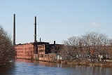
Since the development of industry beginning with the iron works of the mid-17th century, the Taunton River has played an important role in the economy of the Greater Taunton AreaGreater Taunton Area
right|thumb|200px|A map of the Greater Taunton AreaThe Greater Taunton Area is the suburban area surrounding the city of Taunton, in northeastern Bristol County, Massachusetts. It comprises various present-day municipalities that were once under the jurisdiction of Taunton in Colonial America...
. The shipbuilding industry was very active in the Taunton
Taunton, Massachusetts
Taunton is a city in Bristol County, Massachusetts, United States. It is the seat of Bristol County and the hub of the Greater Taunton Area. The city is located south of Boston, east of Providence, north of Fall River and west of Plymouth. The City of Taunton is situated on the Taunton River...
area during the 19th century.
The river today
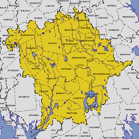
The Taunton River is the longest coastal river in New England without dams and supports 45 species of fish and many species of shellfish. The Taunton River is the principal river that makes up the Taunton River WatershedTaunton River Watershed
right|thumb|200px|An USGS map of the Taunton River WatershedThe Taunton River watershed or Taunton River basin is made up of of rivers, lakes, ponds, streams, and wetlands in southeastern Massachusetts, USA. It is the second largest watershed in the state...
. The watershed is the habitat for 154 types of birds, including 12 rare types. It is also home to otter, mink, grey fox and deer.
Battleship Cove
Battleship Cove
Battleship Cove, located in Fall River, Massachusetts, is a nonprofit maritime museum and war memorial that traces its origins to the wartime crew of the World War II battleship . This dedicated veterans group was responsible for the donation of the decommissioned vessel from the Navy and its...
, the world's largest museum of warships, is located on the Fall River
Fall River
-Cities and towns:In Canada:*Fall River, Nova ScotiaIn the United States:*Fall River, Kansas*Fall River, Massachusetts, the largest city with this name*Fall River, Tennessee*Fall River, Wisconsin*Fall River County, South Dakota-Rivers:In Canada:...
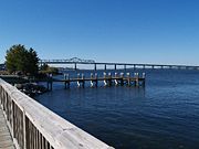
side of the river at its confluence with Mount Hope Bay, beneath the Braga Bridge
Charles M. Braga, Jr. Bridge
At just over a mile long, the Braga Bridge , also known as the Charles M. Braga Jr. Memorial Bridge, is one of the longest bridge structures in Massachusetts. It carries Interstate 195 over the Taunton River between the town of Somerset and the city of Fall River.-History:Construction of the bridge...
.
After over five years of study for possible inclusion in the National Wild and Scenic River
National Wild and Scenic River
National Wild and Scenic River is a designation for certain protected areas in the United States.The National Wild and Scenic Rivers Act was an outgrowth of the recommendations of a Presidential commission, the Outdoor Recreation Resources Review Commission...
System, such designation was obtained in April 2009.
Main Tributaries
- Winnetuxet RiverWinnetuxet RiverThe Winnetuxet River is a river in southeastern Massachusetts. It flows west from an unnamed pond near Cole Mill in Carver, through Plympton and Halifax, to the Taunton River.-External links:*...
, at HalifaxHalifax, MassachusettsHalifax is a town in Plymouth County, Massachusetts, United States. The population was 7,500 at the 2000 census.- History :Halifax was first settled by Europeans, most notably the Bosworth family from Bosworth Fields in England, in 1669, growing with lumbering and agriculture... - Nemasket RiverNemasket RiverThe Nemasket or Namasket River is a small river in southeastern Massachusetts. It flows north from Assawompset Pond in Lakeville and through Middleborough where it empties into the Taunton River....
, at MiddleboroughMiddleborough, MassachusettsMiddleborough is a town in Plymouth County, Massachusetts, United States. The population was 21,117 as of 2008.For geographic and demographic information on the village of Middleborough Center, please see the article Middleborough Center, Massachusetts.... - Mill River, at TauntonTaunton, MassachusettsTaunton is a city in Bristol County, Massachusetts, United States. It is the seat of Bristol County and the hub of the Greater Taunton Area. The city is located south of Boston, east of Providence, north of Fall River and west of Plymouth. The City of Taunton is situated on the Taunton River...
- Three Mile RiverThree Mile RiverThe Three Mile River or Threemile River is a river in Bristol County, Massachusetts. It is formed by the junction of the Rumford and Wading rivers in the town of Norton...
at DightonDighton, MassachusettsDighton is a town in Bristol County, Massachusetts, United States. The population was 6,175 at the 2000 census. The town is located on the western shore of the Taunton River in the southeastern part of the state.- History :... - Assonet RiverAssonet RiverThe Assonet River is located in Bristol County, Massachusetts. It flows in a westerly direction through Freetown and joins the Taunton River near Assonet Neck in Berkley, Massachusetts. -Description:...
at FreetownFreetown, MassachusettsFreetown is a town in Bristol County, Massachusetts, United States. The population was 8,870 at the 2010 census.Freetown is one of the oldest communities in the United States, having been settled by the Pilgrims and their descendants in the latter half of the 17th century. The town once included...
See also
- Fall River, MassachusettsFall River, MassachusettsFall River is a city in Bristol County, Massachusetts, in the United States. It is located about south of Boston, southeast of Providence, Rhode Island, and west of New Bedford and south of Taunton. The city's population was 88,857 during the 2010 census, making it the tenth largest city in...
- List of Massachusetts rivers
- Taunton, MassachusettsTaunton, MassachusettsTaunton is a city in Bristol County, Massachusetts, United States. It is the seat of Bristol County and the hub of the Greater Taunton Area. The city is located south of Boston, east of Providence, north of Fall River and west of Plymouth. The City of Taunton is situated on the Taunton River...
- Three Mile River
- WeetamooWeetamooWeetamoo , also referred to as Weetamoe, was a Pocasset Wampanoag Native American noblewoman who was born in the Mattapoiset village of the Pokanoket and died at Taunton River. Her father was Corbitant, sachem of the Pocasset tribe in present day North Tiverton, Rhode Island, c. 1618–1630...
External links