
Narragansett Bay
Encyclopedia
Bay
A bay is an area of water mostly surrounded by land. Bays generally have calmer waters than the surrounding sea, due to the surrounding land blocking some waves and often reducing winds. Bays also exist as an inlet in a lake or pond. A large bay may be called a gulf, a sea, a sound, or a bight...
and estuary
Estuary
An estuary is a partly enclosed coastal body of water with one or more rivers or streams flowing into it, and with a free connection to the open sea....
on the north side of Rhode Island Sound
Rhode Island Sound
Rhode Island Sound is a strait of water, off the coast of the state of Rhode Island at mouth of Narragansett Bay. It forms the eastern extension of Long Island Sound and opens out the Atlantic Ocean between Block Island and Martha's Vineyard....
. Covering 147 mi2 (380 km2), the Bay forms New England's largest estuary, which functions as an expansive natural harbor, and includes a small archipelago
Archipelago
An archipelago , sometimes called an island group, is a chain or cluster of islands. The word archipelago is derived from the Greek ἄρχι- – arkhi- and πέλαγος – pélagos through the Italian arcipelago...
. This bay is mostly within the state of Rhode Island and Providence Plantations, but small parts of it extend into Massachusetts
Massachusetts
The Commonwealth of Massachusetts is a state in the New England region of the northeastern United States of America. It is bordered by Rhode Island and Connecticut to the south, New York to the west, and Vermont and New Hampshire to the north; at its east lies the Atlantic Ocean. As of the 2010...
.
Of over thirty islands in the Bay, the three largest ones are Aquidneck Island
Aquidneck Island
Aquidneck Island, located in the state of Rhode Island, is the largest island in Narragansett Bay. The island's official name is Rhode Island, and the common use of name "Aquidneck Island" helps distinguish the island from the state. The total land area is 97.9 km²...
, Conanicut Island
Conanicut Island
Conanicut Island is the second largest island in Narragansett Bay, in the state of Rhode Island. It is connected on the east to Newport, Rhode Island, on Aquidneck Island by the Claiborne Pell Bridge, commonly known as the Newport Bridge, and on the west to North Kingstown, Rhode Island, on the...
, and Prudence Island
Prudence Island
Prudence Island is the third largest island in Narragansett Bay in the U.S. state of Rhode Island and part of the town of Portsmouth. It is located near the geographical center of the bay. It is defined by the United States Census Bureau as Block Group 3, Census Tract 401.03 of Newport County,...
. Bodies of water that are part of Narragansett Bay include the Sakonnet River
Sakonnet River
The Sakonnet River is a tidal strait, in the U.S. state of Rhode Island. It flows approximately 23 km between Mount Hope Bay and Rhode Island Sound...
; Mount Hope Bay
Mount Hope Bay
Mount Hope Bay is a tidal estuary located at the mouth of the Taunton River on the Massachusetts and Rhode Island border. It is an arm of Narragansett Bay. The bay is named after Mount Hope, a small hill located on its western shore in what is now Bristol, Rhode Island. It flows into the East...
; and the southern, tidal part of the Taunton River
Taunton River
The Taunton River , is a river in southeastern Massachusetts in the United States. It arises from the confluence of the Town River and Matfield River, in the town of Bridgewater...
. The bay opens on Rhode Island Sound
Rhode Island Sound
Rhode Island Sound is a strait of water, off the coast of the state of Rhode Island at mouth of Narragansett Bay. It forms the eastern extension of Long Island Sound and opens out the Atlantic Ocean between Block Island and Martha's Vineyard....
— Block Island
Block Island
Block Island is part of the U.S. state of Rhode Island and is located in the Atlantic Ocean approximately south of the coast of Rhode Island, east of Montauk Point on Long Island, and is separated from the Rhode Island mainland by Block Island Sound. The United States Census Bureau defines Block...
lies less than 20 miles (32 km) southwest of its opening — and the Atlantic Ocean
Atlantic Ocean
The Atlantic Ocean is the second-largest of the world's oceanic divisions. With a total area of about , it covers approximately 20% of the Earth's surface and about 26% of its water surface area...
. Narragansett Bay can be seen in NOAA chart 13221
Populations

Providence, Rhode Island
Providence is the capital and most populous city of Rhode Island and was one of the first cities established in the United States. Located in Providence County, it is the third largest city in the New England region...
, the Rhode Island
Rhode Island
The state of Rhode Island and Providence Plantations, more commonly referred to as Rhode Island , is a state in the New England region of the United States. It is the smallest U.S. state by area...
state capital and largest city, sits on the west side of the head of the northernmost arm of the bay. Many of Providence's suburbs, including Warwick
Warwick, Rhode Island
Warwick is a city in Kent County, Rhode Island, United States. It is the second largest city in the state, with a population of 82,672 at the 2010 census. Its mayor has been Scott Avedisian since 2000...
and Cranston
Cranston, Rhode Island
Cranston, once known as Pawtuxet, is a city in Providence County, Rhode Island, United States. With a population of 80,387 at the 2010 census, it is the third largest city in the state. The center of population of Rhode Island is located in Cranston...
, are also on the bay. Newport
Newport, Rhode Island
Newport is a city on Aquidneck Island in Newport County, Rhode Island, United States, about south of Providence. Known as a New England summer resort and for the famous Newport Mansions, it is the home of Salve Regina University and Naval Station Newport which houses the United States Naval War...
, the home of the United States Naval War College, the Naval Undersea Warfare Center
Naval Undersea Warfare Center
The Naval Undersea Warfare Center is the United States Navy's full-spectrum research, development, test and evaluation, engineering and fleet support center for submarines, autonomous underwater systems, and offensive and defensive weapons systems associated with undersea warfare...
, and a major United States Navy
United States Navy
The United States Navy is the naval warfare service branch of the United States Armed Forces and one of the seven uniformed services of the United States. The U.S. Navy is the largest in the world; its battle fleet tonnage is greater than that of the next 13 largest navies combined. The U.S...
training center, is located at the south end of Aquidneck Island
Aquidneck Island
Aquidneck Island, located in the state of Rhode Island, is the largest island in Narragansett Bay. The island's official name is Rhode Island, and the common use of name "Aquidneck Island" helps distinguish the island from the state. The total land area is 97.9 km²...
, on the ocean. The city of Fall River, Massachusetts
Fall River, Massachusetts
Fall River is a city in Bristol County, Massachusetts, in the United States. It is located about south of Boston, southeast of Providence, Rhode Island, and west of New Bedford and south of Taunton. The city's population was 88,857 during the 2010 census, making it the tenth largest city in...
is located at the confluence of the Taunton River
Taunton River
The Taunton River , is a river in southeastern Massachusetts in the United States. It arises from the confluence of the Town River and Matfield River, in the town of Bridgewater...
and Mount Hope Bay
Mount Hope Bay
Mount Hope Bay is a tidal estuary located at the mouth of the Taunton River on the Massachusetts and Rhode Island border. It is an arm of Narragansett Bay. The bay is named after Mount Hope, a small hill located on its western shore in what is now Bristol, Rhode Island. It flows into the East...
, which form the northeasternmost part of Narragansett Bay. The southwest side of the bay include the seaside tourist towns of Narragansett
Narragansett, Rhode Island
Narragansett is a town in Washington County, Rhode Island, United States. The population was 15,868 at the 2010 census, but there is a greater population in the summer. The nickname for the town is "Gansett". The town of Narragansett occupies a narrow strip of land running along the eastern bank...
and Wickford
Wickford
Wickford is a town in the south of the English county of Essex, with a population of more than 32,500. Located approximately 30 miles east of London, it falls within the District of Basildon along with Basildon, Billericay, Laindon and Pitsea....
. Quonset Point
Quonset Point
Quonset Point, also known simply as Quonset, is a small peninsula in Narragansett Bay in the U.S. state of Rhode Island. It is contained entirely within the town of North Kingstown. "Quonset" is a Native American word likely meaning "small long place".Quonset Point was the location of Naval Air...
, south of Warwick, gives its name to the Quonset hut
Quonset hut
A Quonset hut is a lightweight prefabricated structure of corrugated galvanized steel having a semicircular cross section. The design was based on the Nissen hut developed by the British during World War I...
. Roger Williams University
Roger Williams University
Roger Williams University, commonly abbreviated as RWU, is a private, coeducational American liberal arts university located on in Bristol, Rhode Island, above Mt. Hope Bay. Founded in 1956, it was named for theologian and Rhode Island cofounder Roger Williams...
is located in Bristol, Rhode Island
Bristol, Rhode Island
Bristol is a town in and the historic county seat of Bristol County, Rhode Island, United States. The population was 22,954 at the 2010 census. Bristol, a deepwater seaport, is named after Bristol, England....
on land overlooking the Bay.
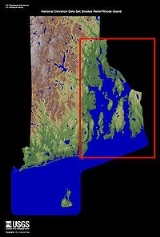
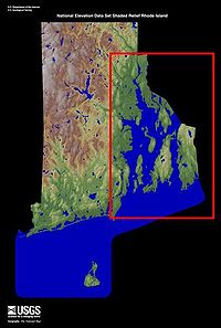
Glacial origins
Narragansett Bay is a riaRia
A ria is a coastal inlet formed by the partial submergence of an unglaciated river valley. It is a drowned river valley that remains open to the sea. Typically, rias have a dendritic, treelike outline although they can be straight and without significant branches. This pattern is inherited from the...
that consists of a series of flooded river valleys formed of dropped crustal blocks in a horst and graben
Graben
In geology, a graben is a depressed block of land bordered by parallel faults. Graben is German for ditch. Graben is used for both the singular and plural....
system that is slowly subsiding between a still-shifting fault system; however, the estuary system is vast compared to the present flow of the three small rivers that enter the bay, in the northeast, the Taunton River
Taunton River
The Taunton River , is a river in southeastern Massachusetts in the United States. It arises from the confluence of the Town River and Matfield River, in the town of Bridgewater...
and in the northwest, the Providence
Providence River
thumb|The city of Providence as seen from the Providence River at its confluence with the Narragansett BayThe Providence River is a tidal river in the U.S. state of Rhode Island. It flows approximately 8 miles...
and Seekonk River
Seekonk River
The Seekonk River is a tidal extension of the Providence River in the U.S. state of Rhode Island. It flows approximately 8 km . Most historical scholars agree that the name is derived from two Native American words, sucki and honc...
s. The present shape of Narragansett Bay is instead the result of the most recent glaciation of New England, under the edges of the Laurentide ice sheet
Laurentide ice sheet
The Laurentide Ice Sheet was a massive sheet of ice that covered hundreds of thousands of square miles, including most of Canada and a large portion of the northern United States, multiple times during Quaternary glacial epochs. It last covered most of northern North America between c. 95,000 and...
at the Last Glacial Maximum
Last Glacial Maximum
The Last Glacial Maximum refers to a period in the Earth's climate history when ice sheets were at their maximum extension, between 26,500 and 19,000–20,000 years ago, marking the peak of the last glacial period. During this time, vast ice sheets covered much of North America, northern Europe and...
, about 18,000 B.P. Sea level
Sea level
Mean sea level is a measure of the average height of the ocean's surface ; used as a standard in reckoning land elevation...
was lowered so much that the continental shelf
Continental shelf
The continental shelf is the extended perimeter of each continent and associated coastal plain. Much of the shelf was exposed during glacial periods, but is now submerged under relatively shallow seas and gulfs, and was similarly submerged during other interglacial periods. The continental margin,...
was exposed, under its weight of ice
Ice
Ice is water frozen into the solid state. Usually ice is the phase known as ice Ih, which is the most abundant of the varying solid phases on the Earth's surface. It can appear transparent or opaque bluish-white color, depending on the presence of impurities or air inclusions...
, and the glacier
Glacier
A glacier is a large persistent body of ice that forms where the accumulation of snow exceeds its ablation over many years, often centuries. At least 0.1 km² in area and 50 m thick, but often much larger, a glacier slowly deforms and flows due to stresses induced by its weight...
calved
Ice calving
Ice calving, also known as glacier calving or iceberg calving, is a form of ice ablation or ice disruption. It is the sudden release and breaking away of a mass of ice from a glacier, iceberg, ice front, ice shelf, or crevasse...
into the Atlantic at its foredge south of Block Island. Glaciers flowing through a geologically old sedimentary basin carved channels through the younger sediments and exposed much older bedrock. North-to-south cuts gouged by the ice can be seen clearly on the map: they form the West Passage that separates Conanicut Island from the western mainland and the East Passage that now separates Conanicut Island from Aquidneck Island.
As the ice stalled, then retreated, the region became ice-free by about 14,000 B.P. A complicated sequence of marine ingression and isostatic rebound
Post-glacial rebound
Post-glacial rebound is the rise of land masses that were depressed by the huge weight of ice sheets during the last glacial period, through a process known as isostasy...
flooded and emptied the landscape. A fresh water proglacial lake
Proglacial lake
In geology, a proglacial lake is a lake formed either by the damming action of a moraine or ice dam during the retreat of a melting glacier, or by meltwater trapped against an ice sheet due to isostatic depression of the crust around the ice...
called by geologists Lake Narragansett formed about 15,500 B.P., impounded behind terminal moraine
Terminal moraine
A terminal moraine, also called end moraine, is a moraine that forms at the end of the glacier called the snout.Terminal moraines mark the maximum advance of the glacier. An end moraine is at the present boundary of the glacier....
s: the lake lasted about 500 years, leaving the powerful flow of a post-glacial river running down its north-south axis. Then salt water filled the valley, as rising sea levels permanently flooded the area.
Early history
The first visit by EuropeansEuropean colonization of the Americas
The start of the European colonization of the Americas is typically dated to 1492. The first Europeans to reach the Americas were the Vikings during the 11th century, who established several colonies in Greenland and one short-lived settlement in present day Newfoundland...
to the bay was probably in the early 16th century. At the time, the area around the bay was inhabited by two different and distinct groups of natives: the Narragansetts
Narragansett (tribe)
The Narragansett tribe are an Algonquian Native American tribe from Rhode Island. In 1983 they regained federal recognition as the Narragansett Indian Tribe of Rhode Island. In 2009, the United States Supreme Court ruled against their request that the Department of Interior take land into trust...
occupied the west side of the bay, and the Wampanoag lived on the east side, occupying the land east to Cape Cod
Cape Cod
Cape Cod, often referred to locally as simply the Cape, is a cape in the easternmost portion of the state of Massachusetts, in the Northeastern United States...
.
It is accepted by most historians that first contact by Europeans was made by Giovanni da Verrazzano, an Italian
Italy
Italy , officially the Italian Republic languages]] under the European Charter for Regional or Minority Languages. In each of these, Italy's official name is as follows:;;;;;;;;), is a unitary parliamentary republic in South-Central Europe. To the north it borders France, Switzerland, Austria and...
explorer who entered the bay in his ship La Dauphine
La Dauphine
La Dauphine was a three-masted sailing vessel that served as the flagship of the explorer Giovanni da Verrazzano on his first voyage to the New World while seeking a shipping passage to China from Europe.-Construction:...
in 1524 after visiting New York Bay
New York Bay
New York Bay is the collective term for the marine areas surrounding the entrance of the Hudson River into the Atlantic Ocean. Its two largest components are Upper New York Bay and Lower New York Bay, which are connected by The Narrows...
. Verrazzano called the bay Refugio, the "Refuge". The bay has several entrances, however, and the exact route of his voyage and the location where he laid anchor is still a subject of dispute among historians, leading to a corresponding uncertainty over which tribe made contact with him. Verrazzano reported that he found clearings and open forests suitable for travel "even by a large army," a far cry from the impenetrable tangle that resulted when the English suppressed controlled burn
Controlled burn
Controlled or prescribed burning, also known as hazard reduction burning or Swailing is a technique sometimes used in forest management, farming, prairie restoration or greenhouse gas abatement. Fire is a natural part of both forest and grassland ecology and controlled fire can be a tool for...
s in the seventeenth century.
Later, in 1614, the bay was explored and mapped by the Dutch
Netherlands
The Netherlands is a constituent country of the Kingdom of the Netherlands, located mainly in North-West Europe and with several islands in the Caribbean. Mainland Netherlands borders the North Sea to the north and west, Belgium to the south, and Germany to the east, and shares maritime borders...
navigator Adriaen Block
Adriaen Block
Adriaen Block was a Dutch private trader and navigator who is best known for exploring the coastal and river valley areas between present-day New Jersey and Massachusetts during four voyages from 1611 to 1614, following the 1609 expedition by Henry Hudson...
, after whom nearby Block Island
Block Island
Block Island is part of the U.S. state of Rhode Island and is located in the Atlantic Ocean approximately south of the coast of Rhode Island, east of Montauk Point on Long Island, and is separated from the Rhode Island mainland by Block Island Sound. The United States Census Bureau defines Block...
is named. The first recorded European settlement was in the 1630s. Roger Williams
Roger Williams (theologian)
Roger Williams was an English Protestant theologian who was an early proponent of religious freedom and the separation of church and state. In 1636, he began the colony of Providence Plantation, which provided a refuge for religious minorities. Williams started the first Baptist church in America,...
, a dissatisfied member of the Plymouth Colony
Plymouth Colony
Plymouth Colony was an English colonial venture in North America from 1620 to 1691. The first settlement of the Plymouth Colony was at New Plymouth, a location previously surveyed and named by Captain John Smith. The settlement, which served as the capital of the colony, is today the modern town...
, moved into the area around the year 1636. He made contact with the Narragansett sachem
Sachem
A sachem[p] or sagamore is a paramount chief among the Algonquians or other northeast American tribes. The two words are anglicizations of cognate terms from different Eastern Algonquian languages...
called Canonicus
Canonicus
Canonicus was a Native American chief of the Narragansett. He was a firm friend of English settlers.-Biography:...
by the Europeans, and set up a trading post on the site of Providence
Providence, Rhode Island
Providence is the capital and most populous city of Rhode Island and was one of the first cities established in the United States. Located in Providence County, it is the third largest city in the New England region...
. At the same time, the Dutch
Netherlands
The Netherlands is a constituent country of the Kingdom of the Netherlands, located mainly in North-West Europe and with several islands in the Caribbean. Mainland Netherlands borders the North Sea to the north and west, Belgium to the south, and Germany to the east, and shares maritime borders...
had established a trading post approximately 12 miles (20 km) to the southwest which was under the authority of New Amsterdam
New Amsterdam
New Amsterdam was a 17th-century Dutch colonial settlement that served as the capital of New Netherland. It later became New York City....
in New York Bay
New York Bay
New York Bay is the collective term for the marine areas surrounding the entrance of the Hudson River into the Atlantic Ocean. Its two largest components are Upper New York Bay and Lower New York Bay, which are connected by The Narrows...
.
In 1643, Williams traveled to England
England
England is a country that is part of the United Kingdom. It shares land borders with Scotland to the north and Wales to the west; the Irish Sea is to the north west, the Celtic Sea to the south west, with the North Sea to the east and the English Channel to the south separating it from continental...
and was granted a charter for the new colony of Rhode Island
Rhode Island
The state of Rhode Island and Providence Plantations, more commonly referred to as Rhode Island , is a state in the New England region of the United States. It is the smallest U.S. state by area...
. He also wrote a dictionary
Dictionary
A dictionary is a collection of words in one or more specific languages, often listed alphabetically, with usage information, definitions, etymologies, phonetics, pronunciations, and other information; or a book of words in one language with their equivalents in another, also known as a lexicon...
of the Narragansett language
Mohegan-Montauk-Narragansett language
Mohegan-Pequot is an extinct Algonquian language formerly spoken in parts of present-day New England and Long Island.As of 2010, the Shinnecock and Unkechaug nations of Long Island, New York, had begun work...
, Keys to the Indian Language, which was published in England that same year.
The Gaspée Affair
Gaspée Affair
The Gaspée Affair was a significant event in the lead-up to the American Revolution. The HMS Gaspée, a British customs schooner that had been enforcing unpopular trade regulations, ran aground in shallow water on June 9, 1772, near what is now known as Gaspee Point in the city of Warwick, Rhode...
, an important naval event of the American Revolution
American Revolution
The American Revolution was the political upheaval during the last half of the 18th century in which thirteen colonies in North America joined together to break free from the British Empire, combining to become the United States of America...
, occurred in 1772 in the bay; it involved the capture of the HMS Gaspee, a British ship. The American victory contributed to the eventual start of the war at the Battles of Lexington and Concord
Battles of Lexington and Concord
The Battles of Lexington and Concord were the first military engagements of the American Revolutionary War. They were fought on April 19, 1775, in Middlesex County, Province of Massachusetts Bay, within the towns of Lexington, Concord, Lincoln, Menotomy , and Cambridge, near Boston...
in Massachusetts three years later. The event is celebrated in Warwick
Warwick, Rhode Island
Warwick is a city in Kent County, Rhode Island, United States. It is the second largest city in the state, with a population of 82,672 at the 2010 census. Its mayor has been Scott Avedisian since 2000...
as the Gaspee Days Celebration in June, which event includes a symbolic recreation of the burning of the ship.
Captain James Cook
James Cook
Captain James Cook, FRS, RN was a British explorer, navigator and cartographer who ultimately rose to the rank of captain in the Royal Navy...
's HMS Endeavour
HMS Endeavour
HMS Endeavour may refer to one of the following ships:In the Royal Navy:, a 36-gun ship purchased in 1652 and sold in 1656, a 4-gun bomb vessel purchased in 1694 and sold in 1696, a fire ship purchased in 1694 and sold in 1696, a storeship hoy purchased in 1694 and sold in 1705, a storeship...
is believed to have been scuttled in the bay, as part of a blockade by the British, whose occupation of Newport was threatened by a fleet carrying French soldiers in support of the Continental Army
Continental Army
The Continental Army was formed after the outbreak of the American Revolutionary War by the colonies that became the United States of America. Established by a resolution of the Continental Congress on June 14, 1775, it was created to coordinate the military efforts of the Thirteen Colonies in...
.
Roger Williams and other early colonists named many of the islands in the bay. To remember the names, colonial school children often recited the poem: "Patience, Prudence, Hope and Despair. And the little Hog over there."
Rivers


- Blackstone RiverBlackstone RiverThe Blackstone River is a river in the U.S. states of Massachusetts and Rhode Island. It flows approximately 48 mi and drains a watershed of approximately 540 sq. mi...
, Woonsocket, Cumberland, Lincoln, Central Falls & Pawtucket, RI - Seekonk RiverSeekonk RiverThe Seekonk River is a tidal extension of the Providence River in the U.S. state of Rhode Island. It flows approximately 8 km . Most historical scholars agree that the name is derived from two Native American words, sucki and honc...
, Pawtucket, East Providence & Providence, RI - Ten Mile RiverTen Mile RiverThe Ten Mile River is a river within the U.S. states of Massachusetts and Rhode Island. It flows approximately and drains a watershed of .The North Attleborough National Fish Hatchery is located in its upper reaches, and the river offers stocked trout fishing in the spring.The Ten Mile River was...
, Pawtucket & East Providence, RI - Moshassuck RiverMoshassuck RiverThe Moshassuck River is a river in the U.S. state of Rhode Island. It flows from the town of Lincoln to the city of Providence. There are six dams along the river's length.- History :...
, Providence, RI - Woonasquatucket RiverWoonasquatucket RiverThe Woonasquatucket River is a river in the U.S. state of Rhode Island. It flows approximately and drains a watershed of 130 km² ....
, Providence, RI - Providence RiverProvidence Riverthumb|The city of Providence as seen from the Providence River at its confluence with the Narragansett BayThe Providence River is a tidal river in the U.S. state of Rhode Island. It flows approximately 8 miles...
, Providence, Cranston, East Providence & Barrington, RI - Pawtuxet RiverPawtuxet RiverThe Pawtuxet River is a river in the U.S. state of Rhode Island. It flows and drains a watershed of . There are four dams along the river's length.-Course:...
, Cranston & Warwick, RI - Potowomut RiverPotowomut RiverThe Potowomut River is a tidal extension of the Hunt River in the U.S. state of Rhode Island. It runs approximately .-Course:The river begins in name just south of Old Forge Road in Warwick where the river becomes the southern boundary of Potowomut Neck...
, aka Greene River, Warwick & North Kingstown, RI - Quequechan RiverQuequechan RiverThe Quequechan River , is a river in Fall River, Massachusetts that flows in a northwesterly direction from the South Watuppa Pond to the Taunton River. The word Quequechan means "falling water" in Wampanoag, hence the city's name....
, aka Quiquechan River, Fall River, MA - Barrington RiverBarrington RiverThe Barrington River is a tidal extension of Runnins River in the U.S. state of Rhode Island and Massachusetts. It flows approximately 6 km . There are no dams along the river's length.-History:...
, Barrington, RI - Palmer RiverPalmer River (Massachusetts-Rhode Island)The Palmer River is a river in the U.S. states of Massachusetts and Rhode Island. It flows approximately 17 km .-Course:The river has two separate branches which converge near the intersection of Danforth Street and Winthrop Street The Palmer River is a river in the U.S. states of...
, Barrington & Warren, RI - Warren RiverWarren RiverThe Warren River is a tidal extension of the Palmer River in the U.S. state of Rhode Island. It flows approximately 6.5 km . There are no dams along the river's length.-Course:...
, Warren & Barrington, RI - Taunton RiverTaunton RiverThe Taunton River , is a river in southeastern Massachusetts in the United States. It arises from the confluence of the Town River and Matfield River, in the town of Bridgewater...
, Tiverton, RI & Fall River, MA - Sakonnet RiverSakonnet RiverThe Sakonnet River is a tidal strait, in the U.S. state of Rhode Island. It flows approximately 23 km between Mount Hope Bay and Rhode Island Sound...
, Tiverton, Little Compton, Portsmouth & Middletown, RI
Rhode Island Navigable Bays, Harbors, Coves, Rivers & Coastal Ponds
Narragansett BayWest Passage—heading north
- Franklin Hollow, Jamestown
- Dutch Island Harbor, Jamestown
- Sheffield Cove, Jamestown
- The Hummocks Cove, North Kingstown
- The Narrows, North Kingstown
- Bissel Cove, North Kingstown
- Duck Cove, North Kingstown
- Wickford Harbor, North Kingstown
- Allen Harbor, North Kingstown
- Hope Island Cove, North Kingstown
- West Passage between Patience & Prudence Islands
- Sheep Pen Cove, Patience Island
- Coggeshell Cove, Prudence Island
- Potowomut RiverPotowomut RiverThe Potowomut River is a tidal extension of the Hunt River in the U.S. state of Rhode Island. It runs approximately .-Course:The river begins in name just south of Old Forge Road in Warwick where the river becomes the southern boundary of Potowomut Neck...
, aka Greene River, North Kingstown & Warwick - Greenwich BayGreenwich Bay (Rhode Island)Greenwich Bay, is a bay on the coast of Rhode Island in the United States near East Greenwich, Rhode Island off of Narragansett Bay.The United States Navy seaplane tender USS Greenwich Bay, in commission from 1945 to 1966, was named for the bay....
, Warwick & East Greenwich - Greenwich Cove, East Greenwich
- Apponaug Cove, Warwick
- Buttonwoods Cove, Warwick
- Brush Neck Cove, Warwick
- Warwick Cove, Warwick
Providence River—heading northwest then southeast
- Old Mill Cove, Warwick
- Occupessatuxet Cove, Warwick
- Passeonkquis Cove, Warwick
- Pawtuxet Cove, Warwick & Cranston
- Stillhouse Cove, Cranston
- Providence Harbor, Providence & East Providence
- Seekonk RiverSeekonk RiverThe Seekonk River is a tidal extension of the Providence River in the U.S. state of Rhode Island. It flows approximately 8 km . Most historical scholars agree that the name is derived from two Native American words, sucki and honc...
, Providence, Pawtucket, East Providence - Pawtucket River, Pawtucket
- Omega Pond, East Providence
- Watchemoket Cove, East Providence
- Bullock Cove, East Providence & Barrington
- Allins Cove, Barrington
- Smith's Cove, Barrington
- Warren RiverWarren RiverThe Warren River is a tidal extension of the Palmer River in the U.S. state of Rhode Island. It flows approximately 6.5 km . There are no dams along the river's length.-Course:...
, Barrington & Warren - Barrington RiverBarrington RiverThe Barrington River is a tidal extension of Runnins River in the U.S. state of Rhode Island and Massachusetts. It flows approximately 6 km . There are no dams along the river's length.-History:...
, Barrington - One Hundred Acre Cove, Barrington
- Palmer RiverPalmer River (Massachusetts-Rhode Island)The Palmer River is a river in the U.S. states of Massachusetts and Rhode Island. It flows approximately 17 km .-Course:The river has two separate branches which converge near the intersection of Danforth Street and Winthrop Street The Palmer River is a river in the U.S. states of...
, Barrington, Warren & Swansea, Massachusetts - Belcher Cove, Warren
- Usher Cove, Bristol
East Passage—going south
- Bristol Harbor, Bristol
- Mill PondMill pondA mill pond is any body of water used as a reservoir for a water-powered mill. Mill ponds were often created through the construction of a mill dam across a waterway. In many places, the common proper name Mill Pond name has remained even though the mill has long since gone...
, Bristol - Walker's Cove, Bristol
- Potter CovePotter CovePotter Cove is a cove indenting the southwest side of King George Island to the east of Barton Peninsula, in the South Shetland Islands. Potter Cove was known to sealers as early as 1821, and the name is now well established in international usage....
, Prudence Island - Cranston Cove, Jamestown
- Potter CovePotter CovePotter Cove is a cove indenting the southwest side of King George Island to the east of Barton Peninsula, in the South Shetland Islands. Potter Cove was known to sealers as early as 1821, and the name is now well established in international usage....
, Jamestown - East Ferry, Jamestown
- Fort Cove, Jamestown
- West Cove, Jamestown
- Hull Cove, Jamestown
- Coggeshall Cove, Portsmouth
- Little Harbor, Melville, Portsmouth
- Coddington Cove, Middletown & Newport
- Coasters Harbor, Newport
- Newport HarborNewport Harbor- Geography :* Newport Beach, California* Newport Harbor High School, in Newport Beach, Orange County, California* Newport Harbor Light, in Newport, Rhode Island* Newport, Rhode Island* Newport, Pembrokeshire...
, Newport - Brenton Cove, Newport
- Castle Hill Cove, Newport
Mount Hope Bay
Mount Hope Bay
Mount Hope Bay is a tidal estuary located at the mouth of the Taunton River on the Massachusetts and Rhode Island border. It is an arm of Narragansett Bay. The bay is named after Mount Hope, a small hill located on its western shore in what is now Bristol, Rhode Island. It flows into the East...
- Church CoveChurch CoveChurch Cove is a hamlet in the civil parish of Landewednack in Cornwall, England. Its nearest town is Helston, which lies approximately north-west from the hamlet. The parish is notable for being the most southern point on British mainland....
, Bristol - Bristol Narrows, Bristol & Warren
- Kickemuit River, Bristol & Warren
- Chase Cove, Warren
- Hog Island Cove, Bristol
Sakonnet River
Sakonnet River
The Sakonnet River is a tidal strait, in the U.S. state of Rhode Island. It flows approximately 23 km between Mount Hope Bay and Rhode Island Sound...
—going south
- The Hummocks, Portsmouth
- The CoveThe CoveThe Cove is a 2009 documentary film that analyzes and questions Japan's dolphin hunting culture. It was awarded the Academy Award for Best Documentary Feature. The film is a call to action to halt mass dolphin kills, change Japanese fishing practices, and to inform and educate the public about the...
, Portsmouth - Blue Bill Cove, Portsmouth
- Old Orchard Cove, Portsmouth
- Long Neck Cove, Portsmouth
- Quaket RiverQuaket RiverThe Quaket River is a tidal inlet, in the U.S. state of Rhode Island. It flows approximately 1 km from the mouth of Nannaquaket Pond in to the Sakonnet River...
, Tiverton - Nannaquaket Pond
- Sapowet Cove, Tiverton
- Fogland Cove, Tiverton
- Church CoveChurch CoveChurch Cove is a hamlet in the civil parish of Landewednack in Cornwall, England. Its nearest town is Helston, which lies approximately north-west from the hamlet. The parish is notable for being the most southern point on British mainland....
, Little Compton
Pawcatuck River—heading upriver
- Little Narragansett BayLittle Narragansett BayLittle Narragansett Bay is an inlet of the Atlantic Ocean and an estuary of the Pawcatuck River on the Rhode Island-Connecticut state line. It is sheltered by a curving peninsula, known as Napatree Point. At the base of Napatree Point is the site of the resort village of Watch Hill, Rhode Island....
, Westerly - The Kitchen Cove, Westerly
- Watch Hill Cove, Westerly
- Potter CovePotter CovePotter Cove is a cove indenting the southwest side of King George Island to the east of Barton Peninsula, in the South Shetland Islands. Potter Cove was known to sealers as early as 1821, and the name is now well established in international usage....
, Westerly - Colonel Willie Cove, Westerly
- Babcock Cove, Westerly
- Mastuxet Cove, Westerly
- Thompson Cove, Westerly
South Coast—from west to east
- Weekapaug Pond, Westerly
- Quonochontaug PondQuonochontaug PondQuonochontaug is a coastal lagoon in the towns of Charlestown and Westerly, both in Washington County, Rhode Island, United States. It is the most saline of nine such lagoons in southern Rhode Island....
, Westerly & Charlestown - Ninigret PondNinigret PondNinigret is a coastal lagoon in Charlestown, Rhode Island in the United States, located at . It is the largest of the nine lagoons, or "salt ponds", in southern Rhode Island. It is utilized for recreational actives, as well as oyster and quahog harvesting. Found along its shores are "extensive"...
, Charlestown - Point Judith PondPoint Judith PondPoint Judith Pond is a shallow, four-mile -long salt body of water lying behind the barrier beaches and sand dunes that form Point Judith Harbor, which lies immediately west of Point Judith in Narragansett, Rhode Island at the southwestern tip of Narragansett Bay...
, South Kingstown & Narragansett - Potter PondPotter PondPotter Pond is a saltwater pond in the town of South Kingstown, Washington County, Rhode Island, United States. Its tidal inlet connects to Point Judith Pond. It is one of nine coastal lagoons, referred to as "salt ponds" by locals, in southern Rhode Island.-See also:*List of lakes in Rhode...
, South Kingstown - Pettaquamscutt RiverPettaquamscutt RiverThe Pettaquamscutt River is a tidal extension of the Mattatuxet River in the U.S. state of Rhode Island. It flows approximately . There are no dams along the river's length.-Course:...
, aka Narrow River, South Kingstown, Narragansett & North Kingstown - Mackerel Cove, Jamestown
- Goose Neck Cove, Newport
- Sheep Point Cove, Newport
- Easton Bay, Newport & Middletown
- Sachuest Bay, Middletown
- Sakonnet Harbor, Little Compton
- Little Pond Cove, Little Compton
Block Island—clockwise from north
- Cow Cove, New Shoreham
- Isaiahs Gully, New Shoreham
- Balls Cove, New Shoreham
- Old Harbor, New Shoreham
- Green Hill Cove, New Shoreham
- Tilson Cove, New Shoreham
- Cat Rock Cove, New Shoreham
- Sand Bank Cove, New Shoreham
- Lighthouse Cove, New Shoreham
- Corn Cove, New Shoreham
- Split Rock Cove, New Shoreham
- Stevens Cove, New Shoreham
- Dories Cove, New Shoreham
- Grace Cove, New Shoreham
- Dead Man's Cove, New Shoreham
- Great Salt PondGreat Salt PondGreat Salt Pond is the largest lake in Saint Kitts and Nevis. it is located close to the end of the Southeast Peninsula, just to the north of The Narrows. It is a habitat for birds like the common moorhen, invertebrates, fish, and is a nursery for other sea dwelling fish....
, New Shoreham - Cormorant Cut, New Shoreham
- Old Breach Cove, New Shoreham
- New HarborNew Harbor, MaineNew Harbor is a small coastal village in the town of Bristol, in Lincoln County, Maine, United States. It is the home of Pemaquid Lighthouse and Fort William Henry....
, New Shoreham - Trims Pond, New Shoreham
- Logwood Cove, New Shoreham
External links
- Narragansett Bay Research Reserve on Prudence Island
- Narragansett Bay Shipping
- Narragansett Bay: A Friend's Perspective
- Narragansett Bay.Org
- Save The Bay
- Narragansett Bay Estuary Program
- 1777 Chart/Map of Narragansett Bay by Charles Blaskowitz and William Faden at DavidRumsey.com