
Glen Canyon Dam
Encyclopedia
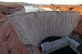
Glen Canyon Dam is a concrete arch dam
on the Colorado River
in northern Arizona
in the United States
, just north of Page
. The dam was built to provide hydroelectricity
and flow regulation from the upper Colorado River Basin to the lower. Its reservoir
is called Lake Powell
, and is the second largest artificial lake in the country, extending upriver well into Utah
. The dam is named for Glen Canyon
, a colorful series of gorges, most of which now lies under the reservoir.
In the early 20th century, seven U.S. state
s and two Mexican
provinces in the Colorado River basin divided the flow of the Colorado River among themselves. Unfortunately, annual flow variations meant that the states in the upper basin would not always be able to deliver the amount of water to the lower basin stipulated by these contracts. The U.S. Bureau of Reclamation proposed a solution that would involve building multiple dams in the upper basin to regulate the flow downstream. However, problems arose when Reclamation proposed to build dams in the federally protected Echo Park
canyon in Utah. After a long legal battle with environmentalist organizations such as the Sierra Club
, they settled for a high dam at Glen Canyon.
Construction of Glen Canyon Dam started in 1956 and was not finished until 1966. When the reservoir filled, the dam began to deliver a steady, regulated flow of water downstream and generate a cheap, plentiful supply of electricity. In 1983, major floods nearly led to the dam's collapse, but disaster was averted by a close margin. By taming floods and other factors that once characterized the Colorado, the dam has led to major physical and ecological changes in the lower river. Controversy continues over the effects both positive and negative of the dam, which has also been referenced from an antagonist view in many works of fiction.
was signed between seven U.S. state
s in 1922 dividing among them the flow of the Colorado River and its tributaries. Each half of the Colorado River Basin – the upper basin, comprising Colorado
, New Mexico
, Utah
and Wyoming
– and the lower basin, with Arizona
, California
and Nevada
– was allotted 7500000 acre.ft of water annually, and a treaty between the U.S. and Mexico was signed in 1944 allocating 1500000 acre.ft to the latter country. The total, 17500000 acre.ft annually, was believed to represent the river's flow at the time as measured at Lee's Ferry, Arizona
(the official dividing point of the upper and lower basins), 16 miles (25.7 km) downstream of present-day Glen Canyon Dam, while in fact it turned out to be the result of one of the Southwest's wettest periods during the past 800 years.
Annual discharge from the Colorado River and its tributaries ranges from 4000000 acre.ft, and 10-year averages may fluctuate as much as 1000000 acre.ft. In addition, the Colorado carries a heavy silt load that led to difficulties for the irrigation interests in the lower Colorado River Valley that were a primary benefactor of the treaties. The location for the needed storage reservoir was debated for years, and in fact Reclamation's first study for a dam at Glen Canyon was made in 1924, in addition to studies for locations at Black
and Boulder Canyons lower on the Colorado, below Grand Canyon.
Instead of Glen Canyon, the initial need for a reservoir was realized in 1936 with the completion of Hoover Dam
, marking the first time man held control of the Colorado. However, even with Lake Mead
's mammoth storage capacity, it was not able to handle the worst floods or droughts, and was filling with sediment at a rate that would render it useless in a few hundred years. But most importantly, Hoover only controlled the lower portion of the river, and the upper basin, whose rivers flowed wild and free, had no way to ensure it could utilize its water allotment in dry years because of the lack of sufficient storage.
 This lack of water surcharge or insurance in the upper Colorado River Basin led to a demand for what would later become the Colorado River Storage Project
. In the 1940s, the Bureau of Reclamation proposed for two storage dams to be built on the Green River
, the Colorado's major upper tributary, at Echo Park
and Split Mountain. The planned dams would have submerged scenic canyons and gorges of Dinosaur National Monument
, a move abhorred by recreationists and environmentalist
s alike.
Led by David Brower, the environmentalist organization Sierra Club
fought a protracted legal battle against Reclamation, on the basis that "building the dam would not only destroy a unique wilderness area, but would set a terrible precedent for exploiting resources in America's national parks and monuments". In the mid-1950s, Reclamation agreed not to build the two dams – an act widely hailed as a major victory for the American environmentalist movement – but only if they could go ahead without opposition with other proposed dams at Flaming Gorge
and Glen Canyon. The Colorado River Storage Project was authorized in April 1956, and groundbreaking of the dam began in October of the same year. A common misconception is that the environmentalists were given a choice between damming Echo Park and damming Glen Canyon, but Reclamation "had always planned to build a dam at Glen Canyon, regardless of the outcome of the Echo Park debate".
In 1963, when construction on the dam was well underway, the Sierra Club published a book on Glen Canyon, The Place No One Knew, lamenting the loss of the scenic gorge before most of the American public had a chance to visit, or indeed know it. Brower had visited Glen Canyon shortly after the decision to build the dam, and "realized once he arrived that this was not a place for a reservoir". This was not strictly true as a handful of hikers and boaters (John Wesley Powell
for whom the reservoir is named, leader of the Powell Geographic Expedition of 1869
, among them) had explored the canyon pre-dam, and some had even been interviewed by Brower. As said to Brower by writer Wallace Stegner
, who had been to the canyon in 1947, "Echo doesn't hold a candle to Glen."
in contrast to the stronger rock at the Hoover Dam site, forcing the Glen Canyon design to follow more conservative lines by greatly thickening the abutments, thus increasing the surface area through which the weight of dam and reservoir would be transmitted to the rock and relieving the pressure per square inch on the highly breakable cliffs. The primary designer and overseer of construction was veteran Reclamation engineer Lem F. Wylie.
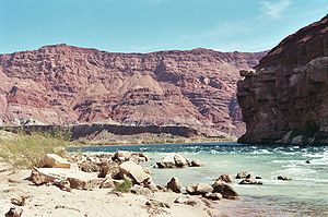
Before building the dam, Reclamation identified two possible sites, both located in the narrow lower reaches of Glen Canyon shortly upstream of Lee's Ferry. One, just 4 miles (6.4 km) upstream, was originally considered the superior site, but the final decision was to build the dam 16.5 miles (26.6 km) upstream because of stronger rock and easier access to the gravel mining area at the confluence of Wahweap Creek with the Colorado. The dam site lay in a remote, rugged area of the Colorado Plateau
, more than 30 miles (48.3 km) from the closest road, U.S. Highway 89, and a whole new road had to be constructed, branching off from Highway 89 north of Flagstaff, Arizona
, and running through the dam site to its terminus at Kanab, Utah
. Because of the isolated location, acquiring the land at the dam and reservoir sites was not incredibly difficult, but still conflicts arose with the ranchers and miners in the area (many of the Navajo
tribe).
As a road link was obviously needed for transport across the canyon from one end of the dam site to the other, a bridge had to be built, several hundred feet downstream of the dam and capable of carrying not only workers but heavy construction material. An earlier footbridge
built of chicken wire and metal grates certainly did not fit the bill. The contract for building the bridge was awarded to Peter Kiewit Sons and the Judson Pacific Murphy Co. for $4 million and construction began in late 1956, reaching completion on August 11, 1957. When finished, the Glen Canyon Bridge was in itself a marvel of engineering: 1271 feet (387.4 m) long and rising 700 feet (213.4 m) above the river, it was the highest bridge of its kind in the United States and one of the highest in the world. By 1959, the bridge itself was a major tourist attraction and it was said that "motorists [were] driving miles out of their way just to be thrilled by its dizzying height".
Workers flooded into the dam site beginning in the mid-late 1950s, and the construction camp started out as a haphazardly organized trailer park
that grew with the workforce. During the construction of the Glen Canyon Bridge, Reclamation also began planning a company town
to house the workers. This resulted in the town of Page, Arizona
, named for former Reclamation commissioner John C. Page. By 1959, Page had a host of temporary buildings, electricity, and a small school serving the workers' children. As the city grew, it gathered additional features, including numerous stores and a hospital, even a jeweler's. It was intended to serve a maximum population of eight thousand, accounting for the workers' families; the peak workforce would eventually exceed 2,500 in the busiest phases of construction.
Dwight D. Eisenhower
pressed a button on his desk in the capital of Washington D.C., sending a telegraph signal that set off the first blast of dynamite at the portal of the right diversion tunnel. Drilling the tunnels through the porous Navajo sandstone abutting the dam site posed major problems for the excavation crews of the Mountain States Construction Company, which won the contract for the diversion tunnels in 1956.
First, transporting workers and equipment to the bottom of the canyon was extremely difficult. Initially, transport was done by barge from the Wahweap Creek gravel deposits shortly upstream, but this was dangerous and was replaced by a vertical cable system when a barge capsized, spilling tons of machinery into the river. The geology of the area also posed problems. During excavation, the rock frequently broke apart or "slabbed" and collapsed into the tunnels, and metal bolts had to be drilled into the rock to secure it. The largest such event, on August 5, 1958, sent 5200 cubic yards (3,975.7 m³) crashing down onto the upper portal of the left diversion tunnel. Material excavated out of the tunnels was used to build the two cofferdam
s that would keep the damsite dry during construction of the dam itself, the last of which was finished in February 1960. On February 11, 1959, the right diversion tunnel was completed and began to carry the flow of the Colorado. The left tunnel was finished over three months later on May 19, 1959, slightly behind schedule.
because of a wage reduction due to the completion of public facilities at Page. In late 1959, salaries were raised by four dollars a day, quelling the strikers. Concrete placement started on June 16, 1960 and started out at a sluggish but growing pace. In 1962 the workforce topped out at nearly 2,500 employees laboring on the dam. Construction would ultimately claim eighteen lives and injure numerous other workers, but contrary to popular myth, no workers were buried alive in the concrete.
A huge concrete plant
capable of putting out 1,450 tons per hour was installed, and a pair of cableways with movable towers with capacities of 50 and 25 tons each spanned the canyon, carrying the 12-ton concrete buckets to their final destinations on the steadily rising crest of the dam. The concrete was poured into modular wooden blocks or "forms", each about the height of a two-story house and measuring up to 60 feet (18.3 m) by 210 feet (64 m); more than 3,000 of these blocks made up the main structure of the dam. Once the concrete dried, the wooden scaffolding was removed and shifted upwards to accommodate the next load of concrete. As construction efficiency increased, the workforce slowly decreased, as new methods of transportation and placement were implemented including conveyors and remotely controlled buckets. By late 1962, concrete was being poured into the dam at a rate of 8000 cubic yards (6,116.4 m³) per day even as the workforce was scaled down to about 1,500.
At the beginning of 1963, the dam was high enough to begin impounding water; huge steel gates were closed over the diversion tunnels on January 2, and Lake Powell began to rise. On that day, Sierra Club leader David Brower made a last-ditch effort to save Glen Canyon from inundation – in the Oval Office – but failed to convince the president. Construction continued and on September 13, 1963, the dam was topped out. Work on the power plant and spillways began directly after the dam wall was complete. The spillway tunnels were excavated around both abutments of the dam and drop steeply from their control gates on Lake Powell to merge with the lower ends of the diversion tunnels. This measure saved cost, but introduced a weak point in the spillways – the point where the spillways met the diversion tunnels had a sudden directional change of 55 degrees from vertical. The upper ends of the diversion tunnels were then sealed with solid concrete. The first electricity was generated on September 4, 1964, with the power sent into the regional electric grid through a pair of long-distance transmission lines as far as Phoenix, Arizona
and Farmington, New Mexico
.
running at full capacity, Lake Powell continued to rise to the point to which the spillway
s had to be opened. Other than brief tests in 1980, this was the only time the spillways had ever been used.
At the beginning of June dam operators opened the gates on the left spillway, sending 10000 cuft/s, just 7.2% of capacity, down the tunnel into the river below. After a few days, the entire dam suddenly began to shake violently. The spillway was closed down for inspections and workers discovered that the flow of water was causing heavy cavitation
(explosive collapse of air bubbles in water moving at high speed) damage to the concrete lining and was eroding away at the rock below. Additionally, the spillway tunnels were designed to feed into the lower ends of the diversion tunnels used during construction as an economic measure. Concrete plugs separate the spillway tunnels from the upper ends of the diversion tunnels, which connect to the bottom of the reservoir. This was rapidly being destroyed by the cavitation and it was feared that a connection would be made to the bottom of Lake Powell, causing it to catastrophically burst through the dam abutment.
 Meanwhile, snow continued melting in the Rockies and Lake Powell continued to rise rapidly. To delay having to use the spillways, Reclamation installed plywood flashboards (later replaced by steel) atop the gates to increase the lake level. Even this additional capacity was exhausted and discharges through the left spillway eventually reached 32000 cuft/s and the right spillway gates were also opened. On July 15, Lake Powell reached its highest recorded level in history. Just as it seemed inevitable that the dam would fail, inflows fell and the dam was saved. Upon inspection, it was found that cavitation had caused massive gouging damage to both spillways, carrying away thousands of tons of concrete, steel rebar and huge chunks of rock.
Repairs to the spillways commenced as soon as possible and continued well into 1984. Aeration slots were installed at the bottom of each spillway to break up and absorb the shock of the bubbles formed by cavitation. 1984 was another year of high water, by some counts comparable or even bigger than 1983, but fortunately Reclamation had drawn down the reservoir enough that it absorbed most of the preliminary flows. Nevertheless, Lake Powell rapidly approached the top of the spillway gates and construction efforts were subsequently focused on the left spillway in order to get it in operation in time. On August 12, the left spillway gates were opened and a torrent of water poured through for hours. The spillway was undamaged, proving the worth of the re-engineering and ensuring that Glen Canyon Dam will also be able to hold against future floods with the magnitude of 1983.
, a figure heavily associated with the building of Glen Canyon Dam and many of the other big dams built by Reclamation. On the other end of the line, David Brower called the dam his worst mistake and "the biggest sin I ever committed" because of the compromise his organization made to build it instead of Echo Park.
On March 21, 1981, one of the more interesting anti-dam protests against Glen Canyon Dam occurred. Four members of the environmental group Earth First!
made the then-emerging organization's debut by unfurling a 300 feet (91.4 m) tapered black sheet of plastic down the face of the dam, making it appear as if a gigantic crack had appeared in the structure, as more than a hundred people looked on. However, authorities were unable to find the individuals responsible.
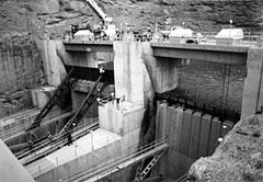
Two spillway
s and four high pressure outlet works
protect the dam against floods. Located on both sides of the dam shortly upstream, the spillways are concrete-lined tunnels that drop sharply through the canyon walls abutting the dam, emptying into the lower ends of the diversion tunnels to save the expense of digging new tunnels. Each spillway is controlled by two 40 feet (12.2 m) long, 52.5 feet (16 m) high radial gates and is capable of carrying 138000 cuft/s for a combined capacity of 276000 cuft/s. The river outlets consist of four 8 feet (2.4 m) diameter pipes each controlled by a follower gate and hollow-jet valve with a capacity of 15000 cuft/s. Glen Canyon's spillways were used for flood purposes only once in 1983, which caused severe damage that nearly led to dam failure (see section above).
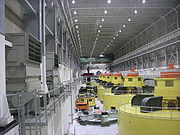 The power plant at Glen Canyon Dam is located at the foot of the structure and contains eight 155,500 horsepower
generators with a combined capacity of 1,296 megawatts. Each generator is driven by a turbine which is in turn fed by a penstock
with a starting diameter of 15 feet (4.6 m), narrowing to 14 feet (4.3 m) as it enters the turbines. Five generators are rated at 165 MW and the remaining three have a capacity of 157 MW each. Before an uprating project in the late 20th century, each of the generators were rated at 118.75 MW for a total of 950 MW. The hydraulic head
for the power plant has a maximum of 510 feet (155.4 m). Power generated at Glen Canyon is distributed by the Western Area Power Administration
.
Lake Powell is the second-largest reservoir in the United States, with a full storage capacity of some 24320000 acre.ft. The original design storage capacity of Powell was some 27000000 acre.ft, but some of it has been compromised by sedimentation. At maximum pool, the reservoir reaches 186 miles (299.3 km) upstream to the mouth of Cataract Canyon
, covering 252 square miles (652.7 km²) with a twisting, winding shoreline of over 2000 miles (3,218.7 km). The active capacity is 20876000 acre.ft and the inactive capacity is 4000000 acre.ft (the lowest point where electricity can still be generated). The dead pool volume is 1900000 acre.ft, marking the lowest point where water can be released through the dam. The Although the dam lies in northern Arizona, the vast majority of the reservoir is actually in southern Utah. Many arms branch off the lake, the longest being those formed by Wahweap Creek, Navajo Creek, Last Chance Creek, the San Juan River, the Escalante River, Halls Creek, and Bullfrog Creek. The reservoir lies mainly in the Glen Canyon National Recreation Area
.
When the dam was first built, the set annual release volume was believed to be the minimum sustainable flow of the Colorado River past the dam site. Reclamation's studies suggested that the Colorado and other tributaries that feed into the reservoir, such as the San Juan and Escalante
, would dump more water into the reservoir during spring runoff than could be efficiently released to maximize power generation on an average of one out of every four years, so the reservoir is operated to reach a peak annual volume of 90% of capacity during July, with power plant releases scheduled based on runoff forecasts. The 1983 and 1984 floods dramatically noted that runoff could not be predicted accurately enough all the time. Since then, even though Glen Canyon was never built for the purpose of flood control, Reclamation has maintained a minimum of 2400000 acre.ft of flood-storage space in the reservoir (approximately 9% of Lake Powell's capacity) to be available on January 1 of any year. In the 21st century, protracted drought caused Lake Powell to drop significantly, reaching a record low of 33% full in 2005, with 2011 being the first year of relief after eight straight years of low water.
The dam's powerplant is operated as a "cash register" power station, meaning that sales of the electricity it generates was used to pay for the original construction cost and is used for maintenance needs as well as a source of revenue for the Bureau of Reclamation. In fact, the primary function of the dam is power production; it wields more than 75% of the hydroelectric capacity of the entire Colorado River Storage Project. The dam also serves as a primary peaking power plant and black start
power source for the electrical grid of much of the southern Intermountain West
. Colorado River flows fluctuate daily below the dam, as much as 15000 cuft/s every 24 hours, depending on power demand. Minimums may drop as low as 1000 cuft/s in December and highs as much as 31500 cuft/s in June and July (the full discharge capacity of the turbines). On average, the power plant uses only 700-900 MW of its 1,296-MW capacity, and produces 4.5 billion kilowatt hours annually.
 Because of its tremendous ecological effect on the Colorado River, the Glen Canyon Dam has inspired heavy controversy from environmentalists. Because of its location in the desert amid porous geology, Lake Powell causes huge evaporation and seepage losses. It is estimated that between 675000 acre.ft and 1000000 acre.ft, with an average of 860000 acre.ft, is lost from the reservoir each year. This amounts to 6-8% of the Colorado River's flow, an increasingly valuable amount of water in an arid land for both humans and the animals and plants that live along the river.
Like all dams, Glen Canyon traps silt, but because the Colorado is an especially high-sediment river, the dam has posed even worse consequences for the river between it and Lake Mead
(essentially, the Grand Canyon). About 100 million tons of sediment are trapped behind the dam annually, equal to about 30,000 dump truck loads daily. Because of the dam, sediment deposited by the Colorado and its tributaries is slowly filling up the canyon, and the most optimistic projections put the useful life of the reservoir at 300–700 years. If no action is taken such as dredging, in a few hundred years, sediment deposits will begin to build up at the foot of the dam and will gradually block the different outlets used to release water. Thus, if drought intervenes during the same period, the dam may not be able to release water due to the blockage of the river outlets and penstocks. The Colorado below the dam would be reduced to a trickle, causing unprecedented loss of riverine life.
The Colorado through Grand Canyon now lacks the source of sediment it needs to build sandbars and islands, and these natural fluvial formations within the canyon have now suffered severe erosion damage. The floods that once scoured the river yearly are now contained behind the dam except in the worst cases; the elimination of this periodic scouring has promoted vegetation encroachment which not only has considerably changed the riparian zone
environment but has created problems for tourism, wherein hikers and rafters often cannot find good spots to camp due to overgrowth. Flow control has also caused an inability of the river to carry away the rockslide
s that are common along the canyons, leading to the creation of incrementally dangerous rapid
s that pose a hazard to fish and boaters alike. Before the dam, the Colorado commonly reached flows of more than 90000 cuft/s during the spring; this has been limited to less than 35000 cuft/s most years with few exceptions.
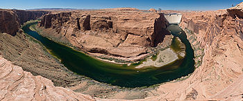
Glen Canyon, which Lake Powell flooded, was really more of a narrow and steep sided valley than a canyon and was once described as the "biological heart" of the Colorado because of its abundant riparian growth and streamside habitat on the numerous low river terraces. The canyon once supported 79 plant species, 189 bird species and 34 kinds of mammals. Below the dam, the Colorado has turned into a "death zone for native fish" such as the endangered humpback chub
as said by Nikolai Ramsey of the Grand Canyon Trust. Throughout most of the year, water released by Glen Canyon is a consistent 47 °F (8.3 °C) due to a thermal mass
effect in Lake Powell where the water typically released from hundreds of feet below the lake surface through the penstocks is insulated from temperature fluctuations by the thick layer of water above it. Pre-dam, the river ranged from over 80 °F (26.7 °C) in the heat of summer to just above 32 °F (0 °C) in winter.
In addition to the effect this has on native fish species, biologist and veteran river guide Michael P. Ghiglieri proposed many drowning deaths by boaters in the Grand Canyon Colorado have been caused or exacerbated by rapid hypothermia and hypothermic shock caused by entering the cold water. He further noted during the record post-dam high-flow season of 1983 (mentioned above), there was only one boating fatality in the canyon, providing a strong challenge to views that the dam, by reducing and mediating river flows, increases the safety of canyon river users. The river water temperature in 1983 was significantly higher than normal, due to a large portion of the water having come from overflows of warmer surface water over the spillways of Glen Canyon Dam, rather than the colder lower levels which feed the penstocks.
Contrary to the initial results, the following years revealed that the offensive vegetation had not been carried away as previously thought – only buried, and had mostly recovered within six months. The surface area of sandbars had been increased, but much of the material had been eroded from the submerged portions of the bars and deposited on top, making them unstable, rather than scoured from the riverbed as hoped. Reclamation has repeated the floods periodically, another time in 2004 and then in 2008. Nevertheless, some continue to believe that the dam has too large and severe of an effect on the river's ecology to make restoration efforts worthwhile.
, which surrounds the reservoir, receives more than 1.9 million visitors annually. About 300,000 of these tourists travel via boat to Rainbow Bridge
in Utah, a large natural arch once very hard to access, but now easily reachable because one of the arms of the reservoir extends under it.
Arch dam
An arch dam is a type of dam that is curved and commonly built with concrete. The arch dam is a structure that is designed to curve upstream so that the force of the water against it, known as hydrostatic pressure, presses against the arch, compressing and strengthening the structure as it pushes...
on the Colorado River
Colorado River
The Colorado River , is a river in the Southwestern United States and northwestern Mexico, approximately long, draining a part of the arid regions on the western slope of the Rocky Mountains. The watershed of the Colorado River covers in parts of seven U.S. states and two Mexican states...
in northern Arizona
Arizona
Arizona ; is a state located in the southwestern region of the United States. It is also part of the western United States and the mountain west. The capital and largest city is Phoenix...
in the United States
United States
The United States of America is a federal constitutional republic comprising fifty states and a federal district...
, just north of Page
Page, Arizona
Page is a city in Coconino County, Arizona, United States, near the Glen Canyon Dam and Lake Powell. According to 2005 Census Bureau estimates, the population of the city is 6,794.-Geography:Page is located at ....
. The dam was built to provide hydroelectricity
Hydroelectricity
Hydroelectricity is the term referring to electricity generated by hydropower; the production of electrical power through the use of the gravitational force of falling or flowing water. It is the most widely used form of renewable energy...
and flow regulation from the upper Colorado River Basin to the lower. Its reservoir
Reservoir
A reservoir , artificial lake or dam is used to store water.Reservoirs may be created in river valleys by the construction of a dam or may be built by excavation in the ground or by conventional construction techniques such as brickwork or cast concrete.The term reservoir may also be used to...
is called Lake Powell
Lake Powell
Lake Powell is a huge reservoir on the Colorado River, straddling the border between Utah and Arizona . It is the second largest man-made reservoir in the United States behind Lake Mead, storing of water when full...
, and is the second largest artificial lake in the country, extending upriver well into Utah
Utah
Utah is a state in the Western United States. It was the 45th state to join the Union, on January 4, 1896. Approximately 80% of Utah's 2,763,885 people live along the Wasatch Front, centering on Salt Lake City. This leaves vast expanses of the state nearly uninhabited, making the population the...
. The dam is named for Glen Canyon
Glen Canyon
Glen Canyon is a canyon that is located in southeastern and south central Utah and northwestern Arizona within the Vermilion Cliffs area. It was carved by the Colorado River....
, a colorful series of gorges, most of which now lies under the reservoir.
In the early 20th century, seven U.S. state
U.S. state
A U.S. state is any one of the 50 federated states of the United States of America that share sovereignty with the federal government. Because of this shared sovereignty, an American is a citizen both of the federal entity and of his or her state of domicile. Four states use the official title of...
s and two Mexican
Mexico
The United Mexican States , commonly known as Mexico , is a federal constitutional republic in North America. It is bordered on the north by the United States; on the south and west by the Pacific Ocean; on the southeast by Guatemala, Belize, and the Caribbean Sea; and on the east by the Gulf of...
provinces in the Colorado River basin divided the flow of the Colorado River among themselves. Unfortunately, annual flow variations meant that the states in the upper basin would not always be able to deliver the amount of water to the lower basin stipulated by these contracts. The U.S. Bureau of Reclamation proposed a solution that would involve building multiple dams in the upper basin to regulate the flow downstream. However, problems arose when Reclamation proposed to build dams in the federally protected Echo Park
Echo Park (Colorado)
Echo Park is a remote river bottom surrounded by canyon walls on the Green River in Dinosaur National Monument. It was first mapped and given its name by the Powell Geographic Expedition in 1869. A proposed dam at Echo Park turned into a nationwide environmental controversy in the early 1950s...
canyon in Utah. After a long legal battle with environmentalist organizations such as the Sierra Club
Sierra Club
The Sierra Club is the oldest, largest, and most influential grassroots environmental organization in the United States. It was founded on May 28, 1892, in San Francisco, California, by the conservationist and preservationist John Muir, who became its first president...
, they settled for a high dam at Glen Canyon.
Construction of Glen Canyon Dam started in 1956 and was not finished until 1966. When the reservoir filled, the dam began to deliver a steady, regulated flow of water downstream and generate a cheap, plentiful supply of electricity. In 1983, major floods nearly led to the dam's collapse, but disaster was averted by a close margin. By taming floods and other factors that once characterized the Colorado, the dam has led to major physical and ecological changes in the lower river. Controversy continues over the effects both positive and negative of the dam, which has also been referenced from an antagonist view in many works of fiction.
Background
The Colorado River CompactColorado River Compact
The Colorado River Compact is a 1922 agreement among seven U.S. states in the basin of the Colorado River in the American Southwest governing the allocation of the water rights to the river's water among the parties of the interstate compact...
was signed between seven U.S. state
U.S. state
A U.S. state is any one of the 50 federated states of the United States of America that share sovereignty with the federal government. Because of this shared sovereignty, an American is a citizen both of the federal entity and of his or her state of domicile. Four states use the official title of...
s in 1922 dividing among them the flow of the Colorado River and its tributaries. Each half of the Colorado River Basin – the upper basin, comprising Colorado
Colorado
Colorado is a U.S. state that encompasses much of the Rocky Mountains as well as the northeastern portion of the Colorado Plateau and the western edge of the Great Plains...
, New Mexico
New Mexico
New Mexico is a state located in the southwest and western regions of the United States. New Mexico is also usually considered one of the Mountain States. With a population density of 16 per square mile, New Mexico is the sixth-most sparsely inhabited U.S...
, Utah
Utah
Utah is a state in the Western United States. It was the 45th state to join the Union, on January 4, 1896. Approximately 80% of Utah's 2,763,885 people live along the Wasatch Front, centering on Salt Lake City. This leaves vast expanses of the state nearly uninhabited, making the population the...
and Wyoming
Wyoming
Wyoming is a state in the mountain region of the Western United States. The western two thirds of the state is covered mostly with the mountain ranges and rangelands in the foothills of the Eastern Rocky Mountains, while the eastern third of the state is high elevation prairie known as the High...
– and the lower basin, with Arizona
Arizona
Arizona ; is a state located in the southwestern region of the United States. It is also part of the western United States and the mountain west. The capital and largest city is Phoenix...
, California
California
California is a state located on the West Coast of the United States. It is by far the most populous U.S. state, and the third-largest by land area...
and Nevada
Nevada
Nevada is a state in the western, mountain west, and southwestern regions of the United States. With an area of and a population of about 2.7 million, it is the 7th-largest and 35th-most populous state. Over two-thirds of Nevada's people live in the Las Vegas metropolitan area, which contains its...
– was allotted 7500000 acre.ft of water annually, and a treaty between the U.S. and Mexico was signed in 1944 allocating 1500000 acre.ft to the latter country. The total, 17500000 acre.ft annually, was believed to represent the river's flow at the time as measured at Lee's Ferry, Arizona
Lee's Ferry
Lee's Ferry is a site on the Colorado River in Coconino County, Arizona, United States, about 7.5 miles southwest of the town of Page, Arizona and the Glen Canyon Dam, and about 9 mi south of the Utah-Arizona border. It is the former location of a ferry established by John D. Lee, a Mormon...
(the official dividing point of the upper and lower basins), 16 miles (25.7 km) downstream of present-day Glen Canyon Dam, while in fact it turned out to be the result of one of the Southwest's wettest periods during the past 800 years.
Annual discharge from the Colorado River and its tributaries ranges from 4000000 acre.ft, and 10-year averages may fluctuate as much as 1000000 acre.ft. In addition, the Colorado carries a heavy silt load that led to difficulties for the irrigation interests in the lower Colorado River Valley that were a primary benefactor of the treaties. The location for the needed storage reservoir was debated for years, and in fact Reclamation's first study for a dam at Glen Canyon was made in 1924, in addition to studies for locations at Black
Black Canyon of the Colorado
The Black Canyon of the Colorado is the canyon on the Colorado River where Hoover Dam was built. The canyon is located on the Colorado River at the state line between Nevada and Arizona. The western wall of the gorge is in the El Dorado Mountains, and the eastern wall is in the Black Mountains of...
and Boulder Canyons lower on the Colorado, below Grand Canyon.
Instead of Glen Canyon, the initial need for a reservoir was realized in 1936 with the completion of Hoover Dam
Hoover Dam
Hoover Dam, once known as Boulder Dam, is a concrete arch-gravity dam in the Black Canyon of the Colorado River, on the border between the US states of Arizona and Nevada. It was constructed between 1931 and 1936 during the Great Depression and was dedicated on September 30, 1935, by President...
, marking the first time man held control of the Colorado. However, even with Lake Mead
Lake Mead
Lake Mead is the largest reservoir in the United States. It is located on the Colorado River about southeast of Las Vegas, Nevada, in the states of Nevada and Arizona. Formed by water impounded by the Hoover Dam, it extends behind the dam, holding approximately of water.-History:The lake was...
's mammoth storage capacity, it was not able to handle the worst floods or droughts, and was filling with sediment at a rate that would render it useless in a few hundred years. But most importantly, Hoover only controlled the lower portion of the river, and the upper basin, whose rivers flowed wild and free, had no way to ensure it could utilize its water allotment in dry years because of the lack of sufficient storage.
Colorado River Storage Project
The Colorado River Storage Project is a United States Bureau of Reclamation project designed to oversee the development of the upper Colorado River basin...
. In the 1940s, the Bureau of Reclamation proposed for two storage dams to be built on the Green River
Green River (Utah)
The Green River, located in the western United States, is the chief tributary of the Colorado River. The watershed of the river, known as the Green River Basin, covers parts of Wyoming, Utah, and Colorado. The Green River is long, beginning in the Wind River Mountains of Wyoming and flowing...
, the Colorado's major upper tributary, at Echo Park
Echo Park (Colorado)
Echo Park is a remote river bottom surrounded by canyon walls on the Green River in Dinosaur National Monument. It was first mapped and given its name by the Powell Geographic Expedition in 1869. A proposed dam at Echo Park turned into a nationwide environmental controversy in the early 1950s...
and Split Mountain. The planned dams would have submerged scenic canyons and gorges of Dinosaur National Monument
Dinosaur National Monument
Dinosaur National Monument is a National Monument located on the southeast flank of the Uinta Mountains on the border between Colorado and Utah at the confluence of the Green and Yampa Rivers. Although most of the monument area is in Moffat County, Colorado, the Dinosaur Quarry is located in Utah...
, a move abhorred by recreationists and environmentalist
Environmentalist
An environmentalist broadly supports the goals of the environmental movement, "a political and ethical movement that seeks to improve and protect the quality of the natural environment through changes to environmentally harmful human activities"...
s alike.
Led by David Brower, the environmentalist organization Sierra Club
Sierra Club
The Sierra Club is the oldest, largest, and most influential grassroots environmental organization in the United States. It was founded on May 28, 1892, in San Francisco, California, by the conservationist and preservationist John Muir, who became its first president...
fought a protracted legal battle against Reclamation, on the basis that "building the dam would not only destroy a unique wilderness area, but would set a terrible precedent for exploiting resources in America's national parks and monuments". In the mid-1950s, Reclamation agreed not to build the two dams – an act widely hailed as a major victory for the American environmentalist movement – but only if they could go ahead without opposition with other proposed dams at Flaming Gorge
Flaming Gorge Dam
The Flaming Gorge Dam is a concrete thin-arch dam in the Flaming Gorge of the Green River, a major tributary of the Colorado River, in the U.S. state of Utah. One of the largest dams in the American West, Flaming Gorge Dam forms the Flaming Gorge Reservoir, which extends into southern Wyoming,...
and Glen Canyon. The Colorado River Storage Project was authorized in April 1956, and groundbreaking of the dam began in October of the same year. A common misconception is that the environmentalists were given a choice between damming Echo Park and damming Glen Canyon, but Reclamation "had always planned to build a dam at Glen Canyon, regardless of the outcome of the Echo Park debate".
In 1963, when construction on the dam was well underway, the Sierra Club published a book on Glen Canyon, The Place No One Knew, lamenting the loss of the scenic gorge before most of the American public had a chance to visit, or indeed know it. Brower had visited Glen Canyon shortly after the decision to build the dam, and "realized once he arrived that this was not a place for a reservoir". This was not strictly true as a handful of hikers and boaters (John Wesley Powell
John Wesley Powell
John Wesley Powell was a U.S. soldier, geologist, explorer of the American West, and director of major scientific and cultural institutions...
for whom the reservoir is named, leader of the Powell Geographic Expedition of 1869
Powell Geographic Expedition of 1869
The Powell Geographic Expedition was a groundbreaking 19th century U.S. exploratory expedition of the American West, led by John Wesley Powell in 1869, that provided the first-ever thorough investigation of the Green and Colorado rivers, including the first known passage through the Grand Canyon...
, among them) had explored the canyon pre-dam, and some had even been interviewed by Brower. As said to Brower by writer Wallace Stegner
Wallace Stegner
Wallace Earle Stegner was an American historian, novelist, short story writer, and environmentalist, often called "The Dean of Western Writers"...
, who had been to the canyon in 1947, "Echo doesn't hold a candle to Glen."
Site preparations
Glen Canyon's design was overall based on that of Hoover Dam, a massive concrete arch-gravity structure anchored in solid bedrock, with several changes. The engineers wanted the dam to rely predominantly on its arch shape to carry the tremendous pressure of the impounded water into the canyon walls instead of depending on the sheer weight of the structure to hold the reservoir back, as had been done at Hoover. However, most of the rock in the region consists of porous and relatively weak Navajo sandstoneNavajo Sandstone
Navajo Sandstone is a geologic formation in the Glen Canyon Group that is spread across the U.S. states of northern Arizona, northwest Colorado, and Utah; as part of the Colorado Plateau province of the United States...
in contrast to the stronger rock at the Hoover Dam site, forcing the Glen Canyon design to follow more conservative lines by greatly thickening the abutments, thus increasing the surface area through which the weight of dam and reservoir would be transmitted to the rock and relieving the pressure per square inch on the highly breakable cliffs. The primary designer and overseer of construction was veteran Reclamation engineer Lem F. Wylie.
Before building the dam, Reclamation identified two possible sites, both located in the narrow lower reaches of Glen Canyon shortly upstream of Lee's Ferry. One, just 4 miles (6.4 km) upstream, was originally considered the superior site, but the final decision was to build the dam 16.5 miles (26.6 km) upstream because of stronger rock and easier access to the gravel mining area at the confluence of Wahweap Creek with the Colorado. The dam site lay in a remote, rugged area of the Colorado Plateau
Colorado Plateau
The Colorado Plateau, also called the Colorado Plateau Province, is a physiographic region of the Intermontane Plateaus, roughly centered on the Four Corners region of the southwestern United States. The province covers an area of 337,000 km2 within western Colorado, northwestern New Mexico,...
, more than 30 miles (48.3 km) from the closest road, U.S. Highway 89, and a whole new road had to be constructed, branching off from Highway 89 north of Flagstaff, Arizona
Flagstaff, Arizona
Flagstaff is a city located in northern Arizona, in the southwestern United States. In 2010, the city's population was 65,870. The population of the Metropolitan Statistical Area was at 134,421 in 2010. It is the county seat of Coconino County...
, and running through the dam site to its terminus at Kanab, Utah
Kanab, Utah
Kanab is a city in and the county seat of Kane County, Utah, United States. The area was first settled in 1864 and the town was founded in 1870 when ten Mormon families moved into the area. The population was 3,564 at the 2000 census...
. Because of the isolated location, acquiring the land at the dam and reservoir sites was not incredibly difficult, but still conflicts arose with the ranchers and miners in the area (many of the Navajo
Navajo people
The Navajo of the Southwestern United States are the largest single federally recognized tribe of the United States of America. The Navajo Nation has 300,048 enrolled tribal members. The Navajo Nation constitutes an independent governmental body which manages the Navajo Indian reservation in the...
tribe).
As a road link was obviously needed for transport across the canyon from one end of the dam site to the other, a bridge had to be built, several hundred feet downstream of the dam and capable of carrying not only workers but heavy construction material. An earlier footbridge
Footbridge
A footbridge or pedestrian bridge is a bridge designed for pedestrians and in some cases cyclists, animal traffic and horse riders, rather than vehicular traffic. Footbridges complement the landscape and can be used decoratively to visually link two distinct areas or to signal a transaction...
built of chicken wire and metal grates certainly did not fit the bill. The contract for building the bridge was awarded to Peter Kiewit Sons and the Judson Pacific Murphy Co. for $4 million and construction began in late 1956, reaching completion on August 11, 1957. When finished, the Glen Canyon Bridge was in itself a marvel of engineering: 1271 feet (387.4 m) long and rising 700 feet (213.4 m) above the river, it was the highest bridge of its kind in the United States and one of the highest in the world. By 1959, the bridge itself was a major tourist attraction and it was said that "motorists [were] driving miles out of their way just to be thrilled by its dizzying height".
Workers flooded into the dam site beginning in the mid-late 1950s, and the construction camp started out as a haphazardly organized trailer park
Trailer park
A trailer park is a semi-permanent or permanent area for mobile homes or travel trailers. The main reasons for living in such trailer parks are the often lower cost compared to other housing, and the ability to move to a new area more quickly and easily, for example when changing jobs to another...
that grew with the workforce. During the construction of the Glen Canyon Bridge, Reclamation also began planning a company town
Company town
A company town is a town or city in which much or all real estate, buildings , utilities, hospitals, small businesses such as grocery stores and gas stations, and other necessities or luxuries of life within its borders are owned by a single company...
to house the workers. This resulted in the town of Page, Arizona
Page, Arizona
Page is a city in Coconino County, Arizona, United States, near the Glen Canyon Dam and Lake Powell. According to 2005 Census Bureau estimates, the population of the city is 6,794.-Geography:Page is located at ....
, named for former Reclamation commissioner John C. Page. By 1959, Page had a host of temporary buildings, electricity, and a small school serving the workers' children. As the city grew, it gathered additional features, including numerous stores and a hospital, even a jeweler's. It was intended to serve a maximum population of eight thousand, accounting for the workers' families; the peak workforce would eventually exceed 2,500 in the busiest phases of construction.
River diversion
In 1956, work began on the two diversion tunnels that would carry the Colorado River around the dam site during construction. Each of the tunnels was 2700 feet (823 m) long and 41 feet (12.5 m) in diameter, and had a combined capacity of 200000 cuft/s. The diversion tunnel at river right would be used for carrying the river's normal flow around the dam site, while the left tunnel, 33 feet (10.1 m) above the water, would only be used during floods. The lower reaches of the tunnels would later be used to form the lower ends of the dam's spillways. On October 15, 1956, PresidentPresident of the United States
The President of the United States of America is the head of state and head of government of the United States. The president leads the executive branch of the federal government and is the commander-in-chief of the United States Armed Forces....
Dwight D. Eisenhower
Dwight D. Eisenhower
Dwight David "Ike" Eisenhower was the 34th President of the United States, from 1953 until 1961. He was a five-star general in the United States Army...
pressed a button on his desk in the capital of Washington D.C., sending a telegraph signal that set off the first blast of dynamite at the portal of the right diversion tunnel. Drilling the tunnels through the porous Navajo sandstone abutting the dam site posed major problems for the excavation crews of the Mountain States Construction Company, which won the contract for the diversion tunnels in 1956.
First, transporting workers and equipment to the bottom of the canyon was extremely difficult. Initially, transport was done by barge from the Wahweap Creek gravel deposits shortly upstream, but this was dangerous and was replaced by a vertical cable system when a barge capsized, spilling tons of machinery into the river. The geology of the area also posed problems. During excavation, the rock frequently broke apart or "slabbed" and collapsed into the tunnels, and metal bolts had to be drilled into the rock to secure it. The largest such event, on August 5, 1958, sent 5200 cubic yards (3,975.7 m³) crashing down onto the upper portal of the left diversion tunnel. Material excavated out of the tunnels was used to build the two cofferdam
Cofferdam
A cofferdam is a temporary enclosure built within, or in pairs across, a body of water and constructed to allow the enclosed area to be pumped out, creating a dry work environment for the major work to proceed...
s that would keep the damsite dry during construction of the dam itself, the last of which was finished in February 1960. On February 11, 1959, the right diversion tunnel was completed and began to carry the flow of the Colorado. The left tunnel was finished over three months later on May 19, 1959, slightly behind schedule.
Concrete placement and completion
With the Colorado River safely out of the dam site, construction could begin on the actual main body of the dam. The contract was given to the Merritt-Chapman & Scott Corporation for an astonishingly low $107,955,552. Unfortunately, right before construction could start, about 750 workers organized a strikeStrike action
Strike action, also called labour strike, on strike, greve , or simply strike, is a work stoppage caused by the mass refusal of employees to work. A strike usually takes place in response to employee grievances. Strikes became important during the industrial revolution, when mass labour became...
because of a wage reduction due to the completion of public facilities at Page. In late 1959, salaries were raised by four dollars a day, quelling the strikers. Concrete placement started on June 16, 1960 and started out at a sluggish but growing pace. In 1962 the workforce topped out at nearly 2,500 employees laboring on the dam. Construction would ultimately claim eighteen lives and injure numerous other workers, but contrary to popular myth, no workers were buried alive in the concrete.
A huge concrete plant
Concrete plant
A concrete plant, also known as a batch plant, is a device that combines various ingredients to form concrete. Some of these inputs include sand, water, aggregate , fly ash, potash, and cement. There are two types of concrete plants: ready mix plants and central mix plants...
capable of putting out 1,450 tons per hour was installed, and a pair of cableways with movable towers with capacities of 50 and 25 tons each spanned the canyon, carrying the 12-ton concrete buckets to their final destinations on the steadily rising crest of the dam. The concrete was poured into modular wooden blocks or "forms", each about the height of a two-story house and measuring up to 60 feet (18.3 m) by 210 feet (64 m); more than 3,000 of these blocks made up the main structure of the dam. Once the concrete dried, the wooden scaffolding was removed and shifted upwards to accommodate the next load of concrete. As construction efficiency increased, the workforce slowly decreased, as new methods of transportation and placement were implemented including conveyors and remotely controlled buckets. By late 1962, concrete was being poured into the dam at a rate of 8000 cubic yards (6,116.4 m³) per day even as the workforce was scaled down to about 1,500.
At the beginning of 1963, the dam was high enough to begin impounding water; huge steel gates were closed over the diversion tunnels on January 2, and Lake Powell began to rise. On that day, Sierra Club leader David Brower made a last-ditch effort to save Glen Canyon from inundation – in the Oval Office – but failed to convince the president. Construction continued and on September 13, 1963, the dam was topped out. Work on the power plant and spillways began directly after the dam wall was complete. The spillway tunnels were excavated around both abutments of the dam and drop steeply from their control gates on Lake Powell to merge with the lower ends of the diversion tunnels. This measure saved cost, but introduced a weak point in the spillways – the point where the spillways met the diversion tunnels had a sudden directional change of 55 degrees from vertical. The upper ends of the diversion tunnels were then sealed with solid concrete. The first electricity was generated on September 4, 1964, with the power sent into the regional electric grid through a pair of long-distance transmission lines as far as Phoenix, Arizona
Phoenix, Arizona
Phoenix is the capital, and largest city, of the U.S. state of Arizona, as well as the sixth most populated city in the United States. Phoenix is home to 1,445,632 people according to the official 2010 U.S. Census Bureau data...
and Farmington, New Mexico
Farmington, New Mexico
Farmington is a city in San Juan County in the U.S. state of New Mexico. As of the 2010 U.S. Census the city had a total population of 45,877 people. Farmington makes up one of the four Metropolitan Statistical Areas in New Mexico. The U.S...
.
1983 floods and legacy
During the first half of 1983, a deep snowpack in the Colorado River headwaters, heavy spring rain and a rapid rise in temperatures that precipitated swift snowmelt combined to create perfect conditions for maximum runoff on the Colorado River. Faulty weather forecasts delayed emergency releases from the dam to prepare for the coming high water, and thus by late May water was pouring into the reservoir at over 110000 cuft/s. Even with the power plant and river outlet worksOutlet works
A set of outlet works is a device used to release and regulate water flow from a dam. Such devices usually consist of one or more pipes or tunnels through the embankment of the dam, directing water usually under high pressure to the river downstream...
running at full capacity, Lake Powell continued to rise to the point to which the spillway
Spillway
A spillway is a structure used to provide the controlled release of flows from a dam or levee into a downstream area, typically being the river that was dammed. In the UK they may be known as overflow channels. Spillways release floods so that the water does not overtop and damage or even destroy...
s had to be opened. Other than brief tests in 1980, this was the only time the spillways had ever been used.
At the beginning of June dam operators opened the gates on the left spillway, sending 10000 cuft/s, just 7.2% of capacity, down the tunnel into the river below. After a few days, the entire dam suddenly began to shake violently. The spillway was closed down for inspections and workers discovered that the flow of water was causing heavy cavitation
Cavitation
Cavitation is the formation and then immediate implosion of cavities in a liquidi.e. small liquid-free zones that are the consequence of forces acting upon the liquid...
(explosive collapse of air bubbles in water moving at high speed) damage to the concrete lining and was eroding away at the rock below. Additionally, the spillway tunnels were designed to feed into the lower ends of the diversion tunnels used during construction as an economic measure. Concrete plugs separate the spillway tunnels from the upper ends of the diversion tunnels, which connect to the bottom of the reservoir. This was rapidly being destroyed by the cavitation and it was feared that a connection would be made to the bottom of Lake Powell, causing it to catastrophically burst through the dam abutment.
Repairs to the spillways commenced as soon as possible and continued well into 1984. Aeration slots were installed at the bottom of each spillway to break up and absorb the shock of the bubbles formed by cavitation. 1984 was another year of high water, by some counts comparable or even bigger than 1983, but fortunately Reclamation had drawn down the reservoir enough that it absorbed most of the preliminary flows. Nevertheless, Lake Powell rapidly approached the top of the spillway gates and construction efforts were subsequently focused on the left spillway in order to get it in operation in time. On August 12, the left spillway gates were opened and a torrent of water poured through for hours. The spillway was undamaged, proving the worth of the re-engineering and ensuring that Glen Canyon Dam will also be able to hold against future floods with the magnitude of 1983.
Continuing debates
Long after the Glen Canyon Dam was built and continuing to the present day, heated debate continues between those who believe the dam should remain in place and those who think it should be removed. "Without Glen Canyon Dam, the big sponge of Lake Powell to absorb the flood years, there's no way that the upper basin states could put their seven and a half million acre feet of water to use. They say now of course that Glen Canyon isn't needed, you don't divert any water out of Lake Powell, well, you do divert water out of Lake Powell by transfer. When you divert water through the mountains in the Utah and Colorado into other uses, it's really out of Lake Powell because it's the big storage that's possible there-- makes possible the upper basin a development," said Former Bureau of Reclamation Commissioner Floyd DominyFloyd Dominy
Floyd E. Dominy was the Nebraska-born Bureau of Reclamation Commissioner from May 1, 1959 to December 1, 1969. Dominy joined the Bureau in 1946. He was the Assistant Commissioner from 1957 to 1958.- References :*...
, a figure heavily associated with the building of Glen Canyon Dam and many of the other big dams built by Reclamation. On the other end of the line, David Brower called the dam his worst mistake and "the biggest sin I ever committed" because of the compromise his organization made to build it instead of Echo Park.
On March 21, 1981, one of the more interesting anti-dam protests against Glen Canyon Dam occurred. Four members of the environmental group Earth First!
Earth First!
Earth First! is a radical environmental advocacy group that emerged in the Southwestern United States in 1979. It was co-founded on April 4th, 1980 by Dave Foreman, Mike Roselle, Howie Wolke, and less directly, Bart Koehler and Ron Kezar....
made the then-emerging organization's debut by unfurling a 300 feet (91.4 m) tapered black sheet of plastic down the face of the dam, making it appear as if a gigantic crack had appeared in the structure, as more than a hundred people looked on. However, authorities were unable to find the individuals responsible.
Structure and storage
The Glen Canyon Dam impounds the Colorado River about 1 mi (1.6 km) northwest of Page in the narrow lower reach of Glen Canyon and 16.4 miles (26.4 km) upstream of Lee's Ferry. The dam is 710 feet (216.4 m) high from the crest to the foundations and has a crest length of 1560 feet (475.5 m). The maximum height above the river is about 583 feet (177.7 m). Overall, the dam relies on its arched design to carry the reservoir's weight into the canyon walls, but because of the sheer scale of the structure and the relatively weak surrounding rock, the dam has medium thickness of about 300 feet (91.4 m) at the widest point. The crest is 3715 feet (1,132.3 m) above sea level and the river immediately downstream sits at 3132 feet (954.6 m).Two spillway
Spillway
A spillway is a structure used to provide the controlled release of flows from a dam or levee into a downstream area, typically being the river that was dammed. In the UK they may be known as overflow channels. Spillways release floods so that the water does not overtop and damage or even destroy...
s and four high pressure outlet works
Outlet works
A set of outlet works is a device used to release and regulate water flow from a dam. Such devices usually consist of one or more pipes or tunnels through the embankment of the dam, directing water usually under high pressure to the river downstream...
protect the dam against floods. Located on both sides of the dam shortly upstream, the spillways are concrete-lined tunnels that drop sharply through the canyon walls abutting the dam, emptying into the lower ends of the diversion tunnels to save the expense of digging new tunnels. Each spillway is controlled by two 40 feet (12.2 m) long, 52.5 feet (16 m) high radial gates and is capable of carrying 138000 cuft/s for a combined capacity of 276000 cuft/s. The river outlets consist of four 8 feet (2.4 m) diameter pipes each controlled by a follower gate and hollow-jet valve with a capacity of 15000 cuft/s. Glen Canyon's spillways were used for flood purposes only once in 1983, which caused severe damage that nearly led to dam failure (see section above).
Horsepower
Horsepower is the name of several units of measurement of power. The most common definitions equal between 735.5 and 750 watts.Horsepower was originally defined to compare the output of steam engines with the power of draft horses in continuous operation. The unit was widely adopted to measure the...
generators with a combined capacity of 1,296 megawatts. Each generator is driven by a turbine which is in turn fed by a penstock
Penstock
A penstock is a sluice or gate or intake structure that controls water flow, or an enclosed pipe that delivers water to hydraulic turbines and sewerage systems. It is a term that has been inherited from the technology of wooden watermills....
with a starting diameter of 15 feet (4.6 m), narrowing to 14 feet (4.3 m) as it enters the turbines. Five generators are rated at 165 MW and the remaining three have a capacity of 157 MW each. Before an uprating project in the late 20th century, each of the generators were rated at 118.75 MW for a total of 950 MW. The hydraulic head
Hydraulic head
Hydraulic head or piezometric head is a specific measurement of water pressure above a geodetic datum. It is usually measured as a water surface elevation, expressed in units of length, at the entrance of a piezometer...
for the power plant has a maximum of 510 feet (155.4 m). Power generated at Glen Canyon is distributed by the Western Area Power Administration
Western Area Power Administration
The Western Area Power Administration markets and delivers hydroelectric power and related services within a 15-state region of the central and western U.S. It is one of four power marketing administrations within the U.S...
.
Lake Powell is the second-largest reservoir in the United States, with a full storage capacity of some 24320000 acre.ft. The original design storage capacity of Powell was some 27000000 acre.ft, but some of it has been compromised by sedimentation. At maximum pool, the reservoir reaches 186 miles (299.3 km) upstream to the mouth of Cataract Canyon
Cataract Canyon
Cataract Canyon is a long canyon of the Colorado River located within Canyonlands National Park and Glen Canyon National Recreation Area in Utah. It begins on the upstream end at the confluence with the Green River and ends at the confluence of the Dirty Devil River...
, covering 252 square miles (652.7 km²) with a twisting, winding shoreline of over 2000 miles (3,218.7 km). The active capacity is 20876000 acre.ft and the inactive capacity is 4000000 acre.ft (the lowest point where electricity can still be generated). The dead pool volume is 1900000 acre.ft, marking the lowest point where water can be released through the dam. The Although the dam lies in northern Arizona, the vast majority of the reservoir is actually in southern Utah. Many arms branch off the lake, the longest being those formed by Wahweap Creek, Navajo Creek, Last Chance Creek, the San Juan River, the Escalante River, Halls Creek, and Bullfrog Creek. The reservoir lies mainly in the Glen Canyon National Recreation Area
Glen Canyon National Recreation Area
Glen Canyon National Recreation Area is a recreation and conservation unit of the National Park Service that encompasses the area around Lake Powell and lower Cataract Canyon in Utah and Arizona, covering 1,254,429 acres of mostly desert...
.
Operations
By and large, the Glen Canyon Dam's main purpose is to fulfill the agreement in the Colorado River Compact made by the upper basin states to allow at least 7500000 acre.ft of water to flow annually past Lee's Ferry for use by Arizona, Nevada and California. The dam is operated to maintain a minimum annual release volume of 8230000 acre.ft or about 11350 cuft/s, which is well over the amount stipulated by the compact but not enough to deliver enough water to Mexico as written in the 1944 Treaty for the Utilization of Waters of the Colorado and Tijuana Rivers and of the Rio Grande. Water for delivery to Mexico is provided by the additional amount released from Glen Canyon – about 730000 acre.ft in the average year – as well as tributaries entering the Colorado between Glen Canyon and Hoover Dam, as well as tributaries below Hoover, although many of those have been diverted for irrigation in central Arizona.When the dam was first built, the set annual release volume was believed to be the minimum sustainable flow of the Colorado River past the dam site. Reclamation's studies suggested that the Colorado and other tributaries that feed into the reservoir, such as the San Juan and Escalante
Escalante River
right|Location of the Escalante River within UtahThe Escalante River is a tributary of the Colorado River. It is formed by the confluence of North and Birch Creeks near the town of Escalante in south-central Utah, and from there flows southeast for approximately before joining Lake Powell...
, would dump more water into the reservoir during spring runoff than could be efficiently released to maximize power generation on an average of one out of every four years, so the reservoir is operated to reach a peak annual volume of 90% of capacity during July, with power plant releases scheduled based on runoff forecasts. The 1983 and 1984 floods dramatically noted that runoff could not be predicted accurately enough all the time. Since then, even though Glen Canyon was never built for the purpose of flood control, Reclamation has maintained a minimum of 2400000 acre.ft of flood-storage space in the reservoir (approximately 9% of Lake Powell's capacity) to be available on January 1 of any year. In the 21st century, protracted drought caused Lake Powell to drop significantly, reaching a record low of 33% full in 2005, with 2011 being the first year of relief after eight straight years of low water.
The dam's powerplant is operated as a "cash register" power station, meaning that sales of the electricity it generates was used to pay for the original construction cost and is used for maintenance needs as well as a source of revenue for the Bureau of Reclamation. In fact, the primary function of the dam is power production; it wields more than 75% of the hydroelectric capacity of the entire Colorado River Storage Project. The dam also serves as a primary peaking power plant and black start
Black start
A black start is the process of restoring a power station to operation without relying on the external electric power transmission network.Normally, the electric power used within the plant is provided from the station's own generators...
power source for the electrical grid of much of the southern Intermountain West
Intermountain West
The Intermountain West is a region of North America lying between the Rocky Mountains to the east and the Cascades and Sierra Nevada to the west. It is also called the Intermountain Region.- Topography :...
. Colorado River flows fluctuate daily below the dam, as much as 15000 cuft/s every 24 hours, depending on power demand. Minimums may drop as low as 1000 cuft/s in December and highs as much as 31500 cuft/s in June and July (the full discharge capacity of the turbines). On average, the power plant uses only 700-900 MW of its 1,296-MW capacity, and produces 4.5 billion kilowatt hours annually.
Environmental impact
Like all dams, Glen Canyon traps silt, but because the Colorado is an especially high-sediment river, the dam has posed even worse consequences for the river between it and Lake Mead
Lake Mead
Lake Mead is the largest reservoir in the United States. It is located on the Colorado River about southeast of Las Vegas, Nevada, in the states of Nevada and Arizona. Formed by water impounded by the Hoover Dam, it extends behind the dam, holding approximately of water.-History:The lake was...
(essentially, the Grand Canyon). About 100 million tons of sediment are trapped behind the dam annually, equal to about 30,000 dump truck loads daily. Because of the dam, sediment deposited by the Colorado and its tributaries is slowly filling up the canyon, and the most optimistic projections put the useful life of the reservoir at 300–700 years. If no action is taken such as dredging, in a few hundred years, sediment deposits will begin to build up at the foot of the dam and will gradually block the different outlets used to release water. Thus, if drought intervenes during the same period, the dam may not be able to release water due to the blockage of the river outlets and penstocks. The Colorado below the dam would be reduced to a trickle, causing unprecedented loss of riverine life.
The Colorado through Grand Canyon now lacks the source of sediment it needs to build sandbars and islands, and these natural fluvial formations within the canyon have now suffered severe erosion damage. The floods that once scoured the river yearly are now contained behind the dam except in the worst cases; the elimination of this periodic scouring has promoted vegetation encroachment which not only has considerably changed the riparian zone
Riparian zone
A riparian zone or riparian area is the interface between land and a river or stream. Riparian is also the proper nomenclature for one of the fifteen terrestrial biomes of the earth. Plant habitats and communities along the river margins and banks are called riparian vegetation, characterized by...
environment but has created problems for tourism, wherein hikers and rafters often cannot find good spots to camp due to overgrowth. Flow control has also caused an inability of the river to carry away the rockslide
Rockslide
A rockslide is a type of landslide caused by rock failure in which part of the plane of failure passes through intact rock and where material collapses en masse and not in individual blocks.The mode of failure is different from that of a rock-fall....
s that are common along the canyons, leading to the creation of incrementally dangerous rapid
Rapid
A rapid is a section of a river where the river bed has a relatively steep gradient causing an increase in water velocity and turbulence. A rapid is a hydrological feature between a run and a cascade. A rapid is characterised by the river becoming shallower and having some rocks exposed above the...
s that pose a hazard to fish and boaters alike. Before the dam, the Colorado commonly reached flows of more than 90000 cuft/s during the spring; this has been limited to less than 35000 cuft/s most years with few exceptions.
Glen Canyon, which Lake Powell flooded, was really more of a narrow and steep sided valley than a canyon and was once described as the "biological heart" of the Colorado because of its abundant riparian growth and streamside habitat on the numerous low river terraces. The canyon once supported 79 plant species, 189 bird species and 34 kinds of mammals. Below the dam, the Colorado has turned into a "death zone for native fish" such as the endangered humpback chub
Humpback chub
The humpback chub Gila cypha, is a federally protected fish that lived originally in fast waters of the Colorado River system in the United States. This species takes its name from the prominent hump between the head and dorsal fin, which is thought to direct the flow of water over the body and...
as said by Nikolai Ramsey of the Grand Canyon Trust. Throughout most of the year, water released by Glen Canyon is a consistent 47 °F (8.3 °C) due to a thermal mass
Thermal mass
Thermal mass is a concept in building design which describes how the mass of the building provides "inertia" against temperature fluctuations, sometimes known as the thermal flywheel effect...
effect in Lake Powell where the water typically released from hundreds of feet below the lake surface through the penstocks is insulated from temperature fluctuations by the thick layer of water above it. Pre-dam, the river ranged from over 80 °F (26.7 °C) in the heat of summer to just above 32 °F (0 °C) in winter.
In addition to the effect this has on native fish species, biologist and veteran river guide Michael P. Ghiglieri proposed many drowning deaths by boaters in the Grand Canyon Colorado have been caused or exacerbated by rapid hypothermia and hypothermic shock caused by entering the cold water. He further noted during the record post-dam high-flow season of 1983 (mentioned above), there was only one boating fatality in the canyon, providing a strong challenge to views that the dam, by reducing and mediating river flows, increases the safety of canyon river users. The river water temperature in 1983 was significantly higher than normal, due to a large portion of the water having come from overflows of warmer surface water over the spillways of Glen Canyon Dam, rather than the colder lower levels which feed the penstocks.
Restoration efforts
On March 26, 1996, the penstocks and two of the outlet works' bypass tubes at Glen Canyon Dam were opened to maximum capacity, producing a flood crest of about 45000 cuft/s on the Colorado River. This was not due to any flood or mechanical failure, but rather was a controlled effort to assist the recovery of the damaged riverine ecosystem by mimicking the spring freshets that once swept through the canyons yearly. The flow appeared to have scoured clean numerous pockets of encroaching vegetation, carried away rockslides that had become dangerous to boaters, and rearranged sand and gravel bars along the river, and was considered an environmental success.Contrary to the initial results, the following years revealed that the offensive vegetation had not been carried away as previously thought – only buried, and had mostly recovered within six months. The surface area of sandbars had been increased, but much of the material had been eroded from the submerged portions of the bars and deposited on top, making them unstable, rather than scoured from the riverbed as hoped. Reclamation has repeated the floods periodically, another time in 2004 and then in 2008. Nevertheless, some continue to believe that the dam has too large and severe of an effect on the river's ecology to make restoration efforts worthwhile.
Recreation
Lake Powell is one of the most popular houseboating and water-skiing areas in the United States; the Glen Canyon National Recreation AreaGlen Canyon National Recreation Area
Glen Canyon National Recreation Area is a recreation and conservation unit of the National Park Service that encompasses the area around Lake Powell and lower Cataract Canyon in Utah and Arizona, covering 1,254,429 acres of mostly desert...
, which surrounds the reservoir, receives more than 1.9 million visitors annually. About 300,000 of these tourists travel via boat to Rainbow Bridge
Rainbow Bridge National Monument
Rainbow Bridge National Monument is administered by Glen Canyon National Recreation Area, southern Utah, USA. Rainbow Bridge is often described as the world's highest natural bridge. The span of Rainbow Bridge was reported in 1974 by the Bureau of Reclamation to be , but a laser measurement in...
in Utah, a large natural arch once very hard to access, but now easily reachable because one of the arms of the reservoir extends under it.
In popular culture
- Edward AbbeyEdward AbbeyEdward Paul Abbey was an American author and essayist noted for his advocacy of environmental issues, criticism of public land policies, and anarchist political views. His best-known works include the novel The Monkey Wrench Gang, which has been cited as an inspiration by radical environmental...
's fictional novel The Monkey Wrench GangThe Monkey Wrench GangThe Monkey Wrench Gang is a novel written by American author Edward Abbey , published in 1975.Easily Abbey's most famous fiction work, the novel concerns the use of sabotage to protest environmentally damaging activities in the American Southwest, and was so influential that the term "monkeywrench"...
describes the efforts of a group of environmentalists who fantasize about blowing up the dam. - In detective novel Wet Desert by Gary Hansen, the Glen Canyon Dam is destroyed by environmental terrorists.
- The dam was used as a shooting location for the 2011 Doctor WhoDoctor WhoDoctor Who is a British science fiction television programme produced by the BBC. The programme depicts the adventures of a time-travelling humanoid alien known as the Doctor who explores the universe in a sentient time machine called the TARDIS that flies through time and space, whose exterior...
episode "Day of the MoonDay of the Moon"Day of the Moon" is the second episode of the sixth series of the British science fiction television series Doctor Who. Written by show runner Steven Moffat, and directed by Toby Haynes, the episode was first broadcast on 30 April 2011 on BBC One in the United Kingdom and on BBC America in the...
." - The dam was used as a location in the television cult classic, Route 66 . "Layout at Glen Canyon" (episode 9, season 1) was broadcast December 2, 1960.