
George Washington Bridge
Encyclopedia
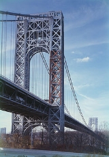
The George Washington Bridge (known informally as the GW Bridge, the GWB, the GW, or the George) is a suspension bridge
spanning the Hudson River
, connecting the Washington Heights
neighborhood in the borough
of Manhattan
in New York City
to Fort Lee
, Bergen County, New Jersey
. Interstate 95
and U.S. Route 1/9
cross the river via the bridge. U.S. Route 46
, which is entirely in New Jersey, ends halfway across the bridge at the state border.
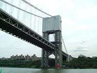
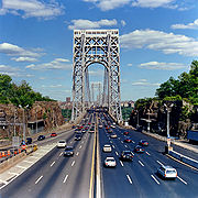
The bridge has an upper level with four lanes in each direction and a lower level with three lanes in each direction, for a total of 14 lanes of travel. The speed limit on the bridge is 45 mph (70 km/h), though congestion often slows traffic, especially during the morning and evening rush hours. A path on each side of the bridge's upper level carries pedestrian and bicycle traffic. As of 2007, the George Washington Bridge has the greatest vehicular capacity of any bridge in the world, carrying approximately 106 million vehicles per year, making it the world's busiest motor vehicle bridge, according to the Port Authority of New York and New Jersey
- the bi-state government agency that owns and operates several area bridges, tunnels, and airports.
. Its chief engineer was Othmar Ammann
, with Cass Gilbert
as architect. When construction started the estimated cost of the bridge was $75,000,000 dollars. The bridge was dedicated on October 24, 1931, and opened to traffic the following day. Initially named the "Hudson River Bridge," the bridge is named in honor of George Washington
, the first President of the United States
. The Bridge is near the sites of Fort Washington
(in New York) and Fort Lee
(in New Jersey), which were fortified positions used by General Washington and his American forces in his unsuccessful attempt to deter the British
occupation of New York City in 1776 during the American Revolutionary War
. Washington evacuated Manhattan
by crossing between the two forts. In 1910 the Washington Chapter of the Daughters of the American Revolution
erected a stone monument to the Battle of Fort Washington
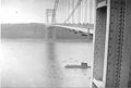
. The monument is located about 100 yards (91.4 m) northeast of the Little Red Lighthouse
, up the hill towards the eastern bridge anchorage.
 When it opened in 1931, the bridge surpassed the Ambassador Bridge
for the longest main span in the world. At 3500 feet (1,066.8 m), it nearly doubled the previous record of 1850 feet (563.9 m). It held this title until the opening of the Golden Gate Bridge
. The total length of the bridge is 4760 feet (1,450.8 m).
As originally built, the bridge offered six lanes of traffic, but in 1946, two additional lanes were provided on what is now the upper level. A second, lower deck, which had been anticipated in Ammann's original plans, was approved by Lt Col Joseph R McCammon, US Army Corps of Engineers
, opening to the public on August 29, 1962. This lower level has been waggishly nicknamed "Martha
". The additional deck increased the capacity of the bridge by 75 percent, making the George Washington Bridge the world's only 14-lane suspension bridge, providing eight lanes on the upper level and six on the lower deck.
The original design for the towers of the bridge called for them to be encased in concrete and granite. However, because of cost considerations during the Great Depression
and favorable aesthetic critiques of the bare steel towers, this was never done. The exposed steel towers, with their distinctive criss-crossed bracing, have become one of the bridge's most identifiable characteristics. Le Corbusier
(Charles-Edouard Jeanneret) said of the unadorned steel structure:
The George Washington Bridge was designated as a National Historic Civil Engineering Landmark by the American Society of Civil Engineers
on October 24, 1981, the fiftieth anniversary of the bridge's dedication ceremony.
Following the September 11 attacks on New York and Washington, the Port Authority prohibited people from taking photographs on the premises of the bridge because of the fear that terrorist groups might study any potential photographs in order to plot a terrorist attack on the bridge. Such prohibitions have since been lifted. As the enclosed lower level is more vulnerable to hazardous material (HAZMAT) incidents than the upper level, most HAZMATs have been prohibited there even before the September 11th attacks. If weather allows, on Martin Luther King, Jr. Day, Presidents Day, Memorial Day
, Flag Day
, Independence Day
, Labor Day
, Columbus Day
, and Veterans Day
, as well as on dates honoring those lost in the September 11 attacks, the bridge sports the largest free-flying American flag
in the world; 90 feet (27 m) long and 60 feet (18.3 m) wide, the flag weighs 450 pounds (200 kg).
, US-1
, and US-9
between New Jersey and New York. US-46
terminates at the state border in the middle of the bridge. I-80
and NJ-4 also feed into the bridge but end before reaching it. On the New Jersey side of the bridge, the Palisades Interstate Parkway
connects directly to the bridge's upper level (plans to give direct access to the lower level from the parkway have been postponed), and the New Jersey Turnpike
connects to both levels of the bridge. The marginal roads and local streets above the highways are known as GWB Plaza.
On the New York side, the twelve-lane Trans-Manhattan Expressway
heads east across the narrow neck of upper Manhattan
, from the bridge to the Harlem River
, providing access from both decks to 178th Street, the Henry Hudson Parkway
and Riverside Drive
on the West Side of Manhattan, and to Amsterdam Avenue
and the Harlem River Drive
on the East Side. The Expressway connects directly with the Alexander Hamilton Bridge
, which spans the Harlem River as part of the Cross-Bronx Expressway
(I-95), providing access to the Major Deegan Expressway
(I-87
). Heading towards New Jersey, local access to the Bridge is available from 179th Street. There are also ramps connecting the bridge to the George Washington Bridge Bus Terminal
, a commuter bus terminal with direct access to the New York City Subway
at the 175th Street
( train) station on the IND Eighth Avenue Line
.
 As of September 18, 2011, the cash toll
s going from New Jersey to New York will now be charged $12 for cars and $11 for motorcycles (there is no toll for passenger vehicles going from New York to New Jersey). All E-ZPass
users will now be charged $7.50 for cars and $6.50 for motorcycles during off-peak hours (outside of 6-10 am and 4-8 pm on the weekdays; and outside of 11 am - 9 pm on the weekends) and $9.50 for cars and $8.50 for motorcycles during peak hours (6-10 am and 4-8 pm on the weekdays; and 11 am - 9 pm on the weekends). Trucks are charged $10 per axle, with significantly discounted off-peak and overnight tolls. A special discounted carpool toll ($3.50) is available for cars with three or more passengers, at all times, with E-ZPass, who proceed through a staffed toll lane (provided they have previously opted-in to the free "Carpool Plan"). The toll is only charged one way (eastbound), which is how all Hudson River crossings are tolled. The George Washington Bridge takes in approximately $1 million per day in tolls.
The bridge has a total of 31 toll lanes, 12 in the upper level toll plaza, 12 in the lower level toll plaza, and seven in the Palisades Interstate Parkway toll plaza. The toll plazas on the lower level and Palisades Parkway are not staffed during the overnight hours and accept only E-ZPass transactions during this period.
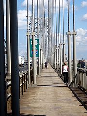
Foot traffic and cyclists cross for free on the sidewalk. Though there are sidewalks on each side of the bridge, cyclists and pedestrians can only use the south side. It offers spectacular views of the Hudson River, the Manhattan skyline and the New Jersey Palisades
. Pedestrians had to pay tolls of 10 cents shortly after the bridge opened, but non-motorized traffic is no longer tolled.
In January 2007 the Port Authority of New York and New Jersey announced a deal with Geico
, the auto insurance giant, that included the posting of a large billboard on top of the toll plaza that said "Geico Drive Safely," and Geico signs on the tollbooths and approach roads, some of which would feature the insurer's signature gecko. The arrangement would have provided the agency with $3.2 million over two years. A week later, however, the Port Authority canceled the contract with Geico after criticism that the signs would mar the landmarked bridge, that the Port Authority had failed to negotiate a good price for the deal and that the placement of the signs might violate Fort Lee's regulations.
 The George Washington Bridge is popular among sightseers
and commuters traveling by foot, bicycle, or roller skates. The South sidewalk (accessible by a long, steep ramp on the Manhattan side of the bridge) is shared by cyclists and pedestrians, with a level surface from end to end. The entrance in Manhattan is at 178th Street, just west of Cabrini Boulevard
which also has access to the Hudson River Greenway north of the bridge. The sidewalk is accessible on the New Jersey side from Hudson Terrace, where a gate open in daytime and evening allows pedestrians and bikes to pass. Also on Hudson Terrace, less than one hundred yards north of the bike/ped entrance, walkers will find the start of the Long Path
hiking trail, which leads after a short walk to some spectacular views of the bridge, and continues north towards Albany, New York
. The George Washington Bridge carries New York State Bicycle Route 9, a bike route that runs from New York City
north to Rouses Point
.
The Port Authority closed the North Sidewalk at all times in 2008. Though offering direct access into Palisades Interstate Park, the North sidewalk requires stairway climbs and descents on both sides, always an inconvenience and obstacle to handicapped people, and a risk in poor weather conditions.
Transportation Alternatives
, a New York City advocacy group, has proposed an enhanced River Road connector in Fort Lee, which would create safer pedestrian and bicycle access to the George Washington Bridge on the New Jersey side of the bridge.
, the Tappan Zee Bridge
(Interstates 87
/287
& New York State Thruway
) is an alternative route that avoids the city proper.
For longer-range traffic, such as traffic between New England (and points north/east) and Pennsylvania (and points south/west), Interstate 84
which crosses the Hudson on the Newburgh–Beacon Bridge is often used as an alternative rather than either the GWB or the Tappan Zee Bridge, as it avoids the core areas of the New York metro area entirely.
. On September 22, 2010, Tyler Clementi, a freshman at Rutgers University
committed suicide by jumping from the bridge, bringing national attention to cyber-bullying
and suicide among LGBT youth
.
, and The Other Guys
. A clip of a drive going over the George Washington Bridge was also shown in the opening of the seventies television show, Maude.
Suspension bridge
A suspension bridge is a type of bridge in which the deck is hung below suspension cables on vertical suspenders. Outside Tibet and Bhutan, where the first examples of this type of bridge were built in the 15th century, this type of bridge dates from the early 19th century...
spanning the Hudson River
Hudson River
The Hudson is a river that flows from north to south through eastern New York. The highest official source is at Lake Tear of the Clouds, on the slopes of Mount Marcy in the Adirondack Mountains. The river itself officially begins in Henderson Lake in Newcomb, New York...
, connecting the Washington Heights
Washington Heights, Manhattan
Washington Heights is a New York City neighborhood in the northern reaches of the borough of Manhattan. It is named for Fort Washington, a fortification constructed at the highest point on Manhattan island by Continental Army troops during the American Revolutionary War, to defend the area from the...
neighborhood in the borough
Borough (New York City)
New York City, one of the largest cities in the world, is composed of five boroughs. Each borough now has the same boundaries as the county it is in. County governments were dissolved when the city consolidated in 1898, along with all city, town, and village governments within each county...
of Manhattan
Manhattan
Manhattan is the oldest and the most densely populated of the five boroughs of New York City. Located primarily on the island of Manhattan at the mouth of the Hudson River, the boundaries of the borough are identical to those of New York County, an original county of the state of New York...
in New York City
New York City
New York is the most populous city in the United States and the center of the New York Metropolitan Area, one of the most populous metropolitan areas in the world. New York exerts a significant impact upon global commerce, finance, media, art, fashion, research, technology, education, and...
to Fort Lee
Fort Lee, New Jersey
Fort Lee is a borough in Bergen County, New Jersey, United States. As of the 2010 United States Census, the borough population was 35,345. Located atop the Hudson Palisades, the borough is the western terminus of the George Washington Bridge...
, Bergen County, New Jersey
Bergen County, New Jersey
Bergen County is the most populous county of the state of New Jersey, United States. As of the 2010 United States Census, its population was 905,116. The county is part of the New York City Metropolitan Area. Its county seat is Hackensack...
. Interstate 95
Interstate 95
Interstate 95 is the main highway on the East Coast of the United States, running parallel to the Atlantic Ocean from Maine to Florida and serving some of the most populated urban areas in the country, including Boston, Providence, New Haven, New York City, Newark, Philadelphia, Baltimore,...
and U.S. Route 1/9
U.S. Route 1/9
U.S. Route 9 is a U.S. highway in the northeast United States, running from Laurel, Delaware north to the Canadian border near Champlain, New York...
cross the river via the bridge. U.S. Route 46
U.S. Route 46
U.S. Route 46 is an east–west U.S. Highway, running for , completely within the state of New Jersey. The west end is at an interchange with Interstate 80 and Route 94 in Columbia, Warren County on the Delaware River...
, which is entirely in New Jersey, ends halfway across the bridge at the state border.
The bridge has an upper level with four lanes in each direction and a lower level with three lanes in each direction, for a total of 14 lanes of travel. The speed limit on the bridge is 45 mph (70 km/h), though congestion often slows traffic, especially during the morning and evening rush hours. A path on each side of the bridge's upper level carries pedestrian and bicycle traffic. As of 2007, the George Washington Bridge has the greatest vehicular capacity of any bridge in the world, carrying approximately 106 million vehicles per year, making it the world's busiest motor vehicle bridge, according to the Port Authority of New York and New Jersey
Port Authority of New York and New Jersey
The Port Authority of New York and New Jersey is a bi-state port district, established in 1921 through an interstate compact, that runs most of the regional transportation infrastructure, including the bridges, tunnels, airports, and seaports, within the Port of New York and New Jersey...
- the bi-state government agency that owns and operates several area bridges, tunnels, and airports.
History
Groundbreaking for the new bridge began in October 1927, a project of the Port of New York AuthorityPort Authority of New York and New Jersey
The Port Authority of New York and New Jersey is a bi-state port district, established in 1921 through an interstate compact, that runs most of the regional transportation infrastructure, including the bridges, tunnels, airports, and seaports, within the Port of New York and New Jersey...
. Its chief engineer was Othmar Ammann
Othmar Ammann
Othmar Hermann Ammann was a American structural engineer whose designs include the George Washington Bridge, Verrazano-Narrows Bridge, and Bayonne Bridge.-Biography:...
, with Cass Gilbert
Cass Gilbert
- Historical impact :Gilbert is considered a skyscraper pioneer; when designing the Woolworth Building he moved into unproven ground — though he certainly was aware of the ground-breaking work done by Chicago architects on skyscrapers and once discussed merging firms with the legendary Daniel...
as architect. When construction started the estimated cost of the bridge was $75,000,000 dollars. The bridge was dedicated on October 24, 1931, and opened to traffic the following day. Initially named the "Hudson River Bridge," the bridge is named in honor of George Washington
George Washington
George Washington was the dominant military and political leader of the new United States of America from 1775 to 1799. He led the American victory over Great Britain in the American Revolutionary War as commander-in-chief of the Continental Army from 1775 to 1783, and presided over the writing of...
, the first President of the United States
President of the United States
The President of the United States of America is the head of state and head of government of the United States. The president leads the executive branch of the federal government and is the commander-in-chief of the United States Armed Forces....
. The Bridge is near the sites of Fort Washington
Fort Washington (New York)
Fort Washington was a fortified position near the north end of Manhattan Island and was located at the highest point on the island. The Fort Washington Site is listed on the U.S...
(in New York) and Fort Lee
Battle of Fort Lee
Fort Lee Historic Park is located atop a bluff of the Hudson Palisades overlooking Burdett's Landing known as Mount Constitution. in Fort Lee, New Jersey. Native Americans appear to have lived in the area for thousands of years before the arrival of Europeans. Site of George Washington's 1776...
(in New Jersey), which were fortified positions used by General Washington and his American forces in his unsuccessful attempt to deter the British
Kingdom of Great Britain
The former Kingdom of Great Britain, sometimes described as the 'United Kingdom of Great Britain', That the Two Kingdoms of Scotland and England, shall upon the 1st May next ensuing the date hereof, and forever after, be United into One Kingdom by the Name of GREAT BRITAIN. was a sovereign...
occupation of New York City in 1776 during the American Revolutionary War
American Revolutionary War
The American Revolutionary War , the American War of Independence, or simply the Revolutionary War, began as a war between the Kingdom of Great Britain and thirteen British colonies in North America, and ended in a global war between several European great powers.The war was the result of the...
. Washington evacuated Manhattan
Manhattan
Manhattan is the oldest and the most densely populated of the five boroughs of New York City. Located primarily on the island of Manhattan at the mouth of the Hudson River, the boundaries of the borough are identical to those of New York County, an original county of the state of New York...
by crossing between the two forts. In 1910 the Washington Chapter of the Daughters of the American Revolution
Daughters of the American Revolution
The Daughters of the American Revolution is a lineage-based membership organization for women who are descended from a person involved in United States' independence....
erected a stone monument to the Battle of Fort Washington
Battle of Fort Washington
The Battle of Fort Washington was fought in the American Revolutionary War between the United States and Great Britain on November 16, 1776. It was a decisive British victory, forcing the entire garrison of Fort Washington to surrender....
. The monument is located about 100 yards (91.4 m) northeast of the Little Red Lighthouse
Little Red Lighthouse
The Little Red Lighthouse, officially Jeffrey's Hook Light is a small lighthouse on the Hudson River in New York City. It was made famous by the 1942 children's book The Little Red Lighthouse and the Great Gray Bridge by Hildegarde Swift and Lynd Ward...
, up the hill towards the eastern bridge anchorage.
Ambassador Bridge
The Ambassador Bridge is a suspension bridge that connects Detroit, Michigan, in the United States, with Windsor, Ontario, in Canada. It is the busiest international border crossing in North America in terms of trade volume: more than 25 percent of all merchandise trade between the United States...
for the longest main span in the world. At 3500 feet (1,066.8 m), it nearly doubled the previous record of 1850 feet (563.9 m). It held this title until the opening of the Golden Gate Bridge
Golden Gate Bridge
The Golden Gate Bridge is a suspension bridge spanning the Golden Gate, the opening of the San Francisco Bay into the Pacific Ocean. As part of both U.S. Route 101 and California State Route 1, the structure links the city of San Francisco, on the northern tip of the San Francisco Peninsula, to...
. The total length of the bridge is 4760 feet (1,450.8 m).
As originally built, the bridge offered six lanes of traffic, but in 1946, two additional lanes were provided on what is now the upper level. A second, lower deck, which had been anticipated in Ammann's original plans, was approved by Lt Col Joseph R McCammon, US Army Corps of Engineers
United States Army Corps of Engineers
The United States Army Corps of Engineers is a federal agency and a major Army command made up of some 38,000 civilian and military personnel, making it the world's largest public engineering, design and construction management agency...
, opening to the public on August 29, 1962. This lower level has been waggishly nicknamed "Martha
Martha Washington
Martha Dandridge Custis Washington was the wife of George Washington, the first president of the United States. Although the title was not coined until after her death, Martha Washington is considered to be the first First Lady of the United States...
". The additional deck increased the capacity of the bridge by 75 percent, making the George Washington Bridge the world's only 14-lane suspension bridge, providing eight lanes on the upper level and six on the lower deck.
The original design for the towers of the bridge called for them to be encased in concrete and granite. However, because of cost considerations during the Great Depression
Great Depression
The Great Depression was a severe worldwide economic depression in the decade preceding World War II. The timing of the Great Depression varied across nations, but in most countries it started in about 1929 and lasted until the late 1930s or early 1940s...
and favorable aesthetic critiques of the bare steel towers, this was never done. The exposed steel towers, with their distinctive criss-crossed bracing, have become one of the bridge's most identifiable characteristics. Le Corbusier
Le Corbusier
Charles-Édouard Jeanneret, better known as Le Corbusier , was a Swiss-born French architect, designer, urbanist, writer and painter, famous for being one of the pioneers of what now is called modern architecture. He was born in Switzerland and became a French citizen in 1930...
(Charles-Edouard Jeanneret) said of the unadorned steel structure:
"The George Washington Bridge over the Hudson is the most beautiful bridge in the world. Made of cables and steel beams, it gleams in the sky like a reversed arch. It is blessed. It is the only seat of grace in the disordered city. It is painted an aluminum color and, between water and sky, you see nothing but the bent cord supported by two steel towers. When your car moves up the ramp the two towers rise so high that it brings you happiness; their structure is so pure, so resolute, so regular that here, finally, steel architecture seems to laugh. The car reaches an unexpectedly wide apron; the second tower is very far away; innumerable vertical cables, gleaming against the sky, are suspended from the magisterial curve which swings down and then up. The rose-colored towers of New York appear, a vision whose harshness is mitigated by distance." (When the Cathedrals were White)
The George Washington Bridge was designated as a National Historic Civil Engineering Landmark by the American Society of Civil Engineers
American Society of Civil Engineers
The American Society of Civil Engineers is a professional body founded in 1852 to represent members of the civil engineering profession worldwide. It is the oldest national engineering society in the United States. ASCE's vision is to have engineers positioned as global leaders who strive toward...
on October 24, 1981, the fiftieth anniversary of the bridge's dedication ceremony.
Following the September 11 attacks on New York and Washington, the Port Authority prohibited people from taking photographs on the premises of the bridge because of the fear that terrorist groups might study any potential photographs in order to plot a terrorist attack on the bridge. Such prohibitions have since been lifted. As the enclosed lower level is more vulnerable to hazardous material (HAZMAT) incidents than the upper level, most HAZMATs have been prohibited there even before the September 11th attacks. If weather allows, on Martin Luther King, Jr. Day, Presidents Day, Memorial Day
Memorial Day
Memorial Day is a United States federal holiday observed on the last Monday of May. Formerly known as Decoration Day, it originated after the American Civil War to commemorate the fallen Union soldiers of the Civil War...
, Flag Day
Flag Day in the United States
In the United States Flag Day is celebrated on June 14. It commemorates the adoption of the flag of the United States, which happened that day by resolution of the Second Continental Congress in 1777...
, Independence Day
Independence Day (United States)
Independence Day, commonly known as the Fourth of July, is a federal holiday in the United States commemorating the adoption of the Declaration of Independence on July 4, 1776, declaring independence from the Kingdom of Great Britain...
, Labor Day
Labor Day
Labor Day is a United States federal holiday observed on the first Monday in September that celebrates the economic and social contributions of workers.-History:...
, Columbus Day
Columbus Day
Many countries in the New World and elsewhere celebrate the anniversary of Christopher Columbus's arrival in the Americas, which occurred on October 12, 1492, as an official holiday...
, and Veterans Day
Veterans Day
Veterans Day, formerly Armistice Day, is an annual United States holiday honoring military veterans. It is a federal holiday that is observed on November 11. It coincides with other holidays such as Armistice Day or Remembrance Day, which are celebrated in other parts of the world and also mark...
, as well as on dates honoring those lost in the September 11 attacks, the bridge sports the largest free-flying American flag
Flag of the United States
The national flag of the United States of America consists of thirteen equal horizontal stripes of red alternating with white, with a blue rectangle in the canton bearing fifty small, white, five-pointed stars arranged in nine offset horizontal rows of six stars alternating with rows...
in the world; 90 feet (27 m) long and 60 feet (18.3 m) wide, the flag weighs 450 pounds (200 kg).
Road connections
The George Washington Bridge carries I-95Interstate 95
Interstate 95 is the main highway on the East Coast of the United States, running parallel to the Atlantic Ocean from Maine to Florida and serving some of the most populated urban areas in the country, including Boston, Providence, New Haven, New York City, Newark, Philadelphia, Baltimore,...
, US-1
U.S. Route 1
U.S. Route 1 is a major north–south U.S. Highway that serves the East Coast of the United States. It runs 2,377 miles from Fort Kent, Maine at the Canadian border south to Key West, Florida. U.S. 1 generally parallels Interstate 95, though it is significantly farther west between...
, and US-9
U.S. Route 9
U.S. Route 9 is a north–south United States highway in the states of Delaware, New Jersey, and New York in the United States. It is one of only two U.S. highways with a ferry connection ; the other being US 10. US 9 is signed east–west in Delaware and north–south on the rest of...
between New Jersey and New York. US-46
U.S. Route 46
U.S. Route 46 is an east–west U.S. Highway, running for , completely within the state of New Jersey. The west end is at an interchange with Interstate 80 and Route 94 in Columbia, Warren County on the Delaware River...
terminates at the state border in the middle of the bridge. I-80
Interstate 80 in New Jersey
Interstate 80 is a major Interstate Highway in the United States, running from the New York City Metropolitan Area westward to San Francisco, California...
and NJ-4 also feed into the bridge but end before reaching it. On the New Jersey side of the bridge, the Palisades Interstate Parkway
Palisades Interstate Parkway
The Palisades Interstate Parkway is a long limited-access highway in the U.S. states of New Jersey and New York. The parkway is a major commuter route into New York City from Rockland and Orange counties in New York and Bergen County in New Jersey...
connects directly to the bridge's upper level (plans to give direct access to the lower level from the parkway have been postponed), and the New Jersey Turnpike
New Jersey Turnpike
The New Jersey Turnpike is a toll road in New Jersey, maintained by the New Jersey Turnpike Authority. According to the International Bridge, Tunnel and Turnpike Association, the Turnpike is the nation's sixth-busiest toll road and is among one of the most heavily traveled highways in the United...
connects to both levels of the bridge. The marginal roads and local streets above the highways are known as GWB Plaza.
On the New York side, the twelve-lane Trans-Manhattan Expressway
Trans-Manhattan Expressway
The Trans-Manhattan Expressway or George Washington Bridge Expressway is a highway in New York City that is part of the Interstate Highway System. Though few of the millions who use it or live near it have ever heard the name, it is probably one of the shortest, busiest, and most congested named...
heads east across the narrow neck of upper Manhattan
Upper Manhattan
Upper Manhattan denotes the more northerly region of the New York City Borough of Manhattan. Its southern boundary may be defined anywhere between 59th Street and 155th Street. Between these two extremes lies the most common definitions of Upper Manhattan as Manhattan above 96th Street...
, from the bridge to the Harlem River
Harlem River
The Harlem River is a navigable tidal strait in New York City, USA that flows 8 miles between the Hudson River and the East River, separating the boroughs of Manhattan and the Bronx...
, providing access from both decks to 178th Street, the Henry Hudson Parkway
Henry Hudson Parkway
The Henry Hudson Parkway is an long parkway in New York City. The southern terminus is at West 72nd Street in Manhattan, where the parkway continues south as the West Side Highway. It is often erroneously referred to as the West Side Highway throughout its entire course in Manhattan...
and Riverside Drive
Riverside Drive (Manhattan)
Riverside Drive is a scenic north-south thoroughfare in the Manhattan borough of New York City. The boulevard runs on the west side of Manhattan, generally parallel to the Hudson River from 72nd Street to near the George Washington Bridge at 181st Street...
on the West Side of Manhattan, and to Amsterdam Avenue
Tenth Avenue (Manhattan)
Tenth Avenue, known as Amsterdam Avenue north of 59th Street, is a north-south thoroughfare on the West Side of Manhattan in New York City. It carries uptown traffic as far as West 110th Street, also known as Cathedral Parkway for the Cathedral Church of St. John the Divine...
and the Harlem River Drive
Harlem River Drive
The Harlem River Drive is a north–south parkway in the New York City borough of Manhattan. It runs along the west bank of the Harlem River from the Triborough Bridge in East Harlem to 10th Avenue in Inwood, where the parkway continues north as Dyckman Street. The portion of the Harlem River Drive...
on the East Side. The Expressway connects directly with the Alexander Hamilton Bridge
Alexander Hamilton Bridge
The Alexander Hamilton Bridge carries eight lanes of traffic over the Harlem River in New York City between the boroughs of Manhattan and the Bronx, connecting the Trans-Manhattan Expressway in the Washington Heights section of Manhattan and the Cross-Bronx Expressway, as part of Interstate 95...
, which spans the Harlem River as part of the Cross-Bronx Expressway
Cross-Bronx Expressway
The Cross Bronx Expressway is a major expressway in the New York City borough of the Bronx, conceived by Robert Moses and built between 1948 and 1972. It carries traffic on Interstate 95 through the city, and serves as a portion of Interstate 295 toward Long Island; a portion is also designated U.S...
(I-95), providing access to the Major Deegan Expressway
Major Deegan Expressway
The Major Deegan Expressway is a north–south expressway in the New York City borough of the Bronx...
(I-87
Interstate 87
Interstate 87 is a Interstate Highway located entirely within New York State in the United States of America. I-87 is the longest intrastate Interstate highway in the Interstate Highway System. Its southern end is at the Bronx approaches of the Robert F. Kennedy Bridge in New York City...
). Heading towards New Jersey, local access to the Bridge is available from 179th Street. There are also ramps connecting the bridge to the George Washington Bridge Bus Terminal
George Washington Bridge Bus Terminal
The George Washington Bridge Bus Station is a commuter bus terminal located at the east end of the George Washington Bridge in the Washington Heights area of Manhattan in New York City, New York....
, a commuter bus terminal with direct access to the New York City Subway
New York City Subway
The New York City Subway is a rapid transit system owned by the City of New York and leased to the New York City Transit Authority, a subsidiary agency of the Metropolitan Transportation Authority and also known as MTA New York City Transit...
at the 175th Street
175th Street (IND Eighth Avenue Line)
175th Street is a station on the IND Eighth Avenue Line of the New York City Subway. Located in the neighborhood of Washington Heights in Upper Manhattan, at 175th Street and Fort Washington Avenue, it is served by the A train at all times...
( train) station on the IND Eighth Avenue Line
IND Eighth Avenue Line
The Eighth Avenue Line is a rapid transit line in New York City, United States, and is part of the B Division of the New York City Subway...
.
Tolls
Toll bridge
A toll bridge is a bridge over which traffic may pass upon payment of a toll, or fee.- History :The practice of collecting tolls on bridges probably harks back to the days of ferry crossings where people paid a fee to be ferried across stretches of water. As boats became impractical to carry large...
s going from New Jersey to New York will now be charged $12 for cars and $11 for motorcycles (there is no toll for passenger vehicles going from New York to New Jersey). All E-ZPass
E-ZPass
E-ZPass is an electronic toll-collection system used on most tolled roads, bridges, and tunnels in the northeastern US, south to Virginia and West Virginia, and west to Illinois. Currently, there are 25 agencies spread across 14 states that make up the . All member agencies use the same technology,...
users will now be charged $7.50 for cars and $6.50 for motorcycles during off-peak hours (outside of 6-10 am and 4-8 pm on the weekdays; and outside of 11 am - 9 pm on the weekends) and $9.50 for cars and $8.50 for motorcycles during peak hours (6-10 am and 4-8 pm on the weekdays; and 11 am - 9 pm on the weekends). Trucks are charged $10 per axle, with significantly discounted off-peak and overnight tolls. A special discounted carpool toll ($3.50) is available for cars with three or more passengers, at all times, with E-ZPass, who proceed through a staffed toll lane (provided they have previously opted-in to the free "Carpool Plan"). The toll is only charged one way (eastbound), which is how all Hudson River crossings are tolled. The George Washington Bridge takes in approximately $1 million per day in tolls.
The bridge has a total of 31 toll lanes, 12 in the upper level toll plaza, 12 in the lower level toll plaza, and seven in the Palisades Interstate Parkway toll plaza. The toll plazas on the lower level and Palisades Parkway are not staffed during the overnight hours and accept only E-ZPass transactions during this period.
Foot traffic and cyclists cross for free on the sidewalk. Though there are sidewalks on each side of the bridge, cyclists and pedestrians can only use the south side. It offers spectacular views of the Hudson River, the Manhattan skyline and the New Jersey Palisades
New Jersey Palisades
The Palisades, also called the New Jersey Palisades or the Hudson Palisades are a line of steep cliffs along the west side of the lower Hudson River in northeastern New Jersey and southern New York in the United States. The cliffs stretch north from Jersey City approximately 20 mi to near...
. Pedestrians had to pay tolls of 10 cents shortly after the bridge opened, but non-motorized traffic is no longer tolled.
In January 2007 the Port Authority of New York and New Jersey announced a deal with Geico
GEICO
The Government Employees Insurance Company is an auto insurance company. It is a wholly owned subsidiary of Berkshire Hathaway that as of 2007 provided coverage for more than 10 million motor vehicles owned by more than 9 million policy holders. GEICO writes private passenger automobile insurance...
, the auto insurance giant, that included the posting of a large billboard on top of the toll plaza that said "Geico Drive Safely," and Geico signs on the tollbooths and approach roads, some of which would feature the insurer's signature gecko. The arrangement would have provided the agency with $3.2 million over two years. A week later, however, the Port Authority canceled the contract with Geico after criticism that the signs would mar the landmarked bridge, that the Port Authority had failed to negotiate a good price for the deal and that the placement of the signs might violate Fort Lee's regulations.
Non-motorized access
Tourism in New York City
Tourism in New York City includes nearly 47 million foreign and American tourists each year. Major destinations include the Empire State Building, Ellis Island, Broadway theatre productions, museums such as the Metropolitan Museum of Art, and other tourist attractions including Central Park,...
and commuters traveling by foot, bicycle, or roller skates. The South sidewalk (accessible by a long, steep ramp on the Manhattan side of the bridge) is shared by cyclists and pedestrians, with a level surface from end to end. The entrance in Manhattan is at 178th Street, just west of Cabrini Boulevard
Cabrini Boulevard (Manhattan)
Cabrini Boulevard spans the Manhattan neighborhood of Hudson Heights, running from West 177th Street in the south, near the George Washington Bridge, to Fort Tryon Park in the north, along an escarpment of Manhattan schist overlooking the Henry Hudson Parkway and the Hudson River...
which also has access to the Hudson River Greenway north of the bridge. The sidewalk is accessible on the New Jersey side from Hudson Terrace, where a gate open in daytime and evening allows pedestrians and bikes to pass. Also on Hudson Terrace, less than one hundred yards north of the bike/ped entrance, walkers will find the start of the Long Path
Long Path
The Long Path is a long-distance hiking trail beginning at the George Washington Bridge in Fort Lee, New Jersey and currently ending at Altamont, New York, in the Albany area...
hiking trail, which leads after a short walk to some spectacular views of the bridge, and continues north towards Albany, New York
Albany, New York
Albany is the capital city of the U.S. state of New York, the seat of Albany County, and the central city of New York's Capital District. Roughly north of New York City, Albany sits on the west bank of the Hudson River, about south of its confluence with the Mohawk River...
. The George Washington Bridge carries New York State Bicycle Route 9, a bike route that runs from New York City
New York City
New York is the most populous city in the United States and the center of the New York Metropolitan Area, one of the most populous metropolitan areas in the world. New York exerts a significant impact upon global commerce, finance, media, art, fashion, research, technology, education, and...
north to Rouses Point
Rouses Point, New York
Rouses Point is a village in Clinton County, New York, United States, along the 45th parallel. The population was 2,209 at the 2010 census. The village is named after Jacques Rouse, an early settler....
.
The Port Authority closed the North Sidewalk at all times in 2008. Though offering direct access into Palisades Interstate Park, the North sidewalk requires stairway climbs and descents on both sides, always an inconvenience and obstacle to handicapped people, and a risk in poor weather conditions.
Transportation Alternatives
Transportation Alternatives
Transportation Alternatives is a non-profit organization in New York City which seeks to change New York City's transportation priorities to encourage and increase non-polluting, quiet, city-friendly travel and decrease private car use...
, a New York City advocacy group, has proposed an enhanced River Road connector in Fort Lee, which would create safer pedestrian and bicycle access to the George Washington Bridge on the New Jersey side of the bridge.
Alternate routes
Within the New York metropolitan areaNew York metropolitan area
The New York metropolitan area, also known as Greater New York, or the Tri-State area, is the region that composes of New York City and the surrounding region...
, the Tappan Zee Bridge
Tappan Zee Bridge
The Governor Malcolm Wilson Tappan Zee Bridge, usually referred to as Tappan Zee Bridge, is a cantilever bridge in New York over the Hudson River at one of its widest points; the Tappan Zee is named for an American Indian tribe from the area called "Tappan"; and zee being the Dutch word for "sea"....
(Interstates 87
Interstate 87
Interstate 87 is a Interstate Highway located entirely within New York State in the United States of America. I-87 is the longest intrastate Interstate highway in the Interstate Highway System. Its southern end is at the Bronx approaches of the Robert F. Kennedy Bridge in New York City...
/287
Interstate 287
Interstate 287 is an auxiliary Interstate Highway in the U.S. states of New Jersey and New York. It is a partial beltway around New York City, serving the northern half of New Jersey and the counties of Rockland and Westchester in New York...
& New York State Thruway
New York State Thruway
The New York State Thruway is a system of limited-access highways located within the state of New York in the United States. The system, known officially as the Governor Thomas E. Dewey Thruway for former New York Governor Thomas E. Dewey, is operated by the New York State Thruway Authority and...
) is an alternative route that avoids the city proper.
For longer-range traffic, such as traffic between New England (and points north/east) and Pennsylvania (and points south/west), Interstate 84
Interstate 84
Interstate 84 may refer to:*Interstate 84 , a freeway extending from Scranton, Pennsylvania to Sturbridge, Massachusetts at the Massachusetts Turnpike *Interstate 84 , a freeway extending from Portland, Oregon to Echo, Utah...
which crosses the Hudson on the Newburgh–Beacon Bridge is often used as an alternative rather than either the GWB or the Tappan Zee Bridge, as it avoids the core areas of the New York metro area entirely.
Suicides
The George Washington Bridge is among the sites in New York City often chosen by people who commit suicideSuicide
Suicide is the act of intentionally causing one's own death. Suicide is often committed out of despair or attributed to some underlying mental disorder, such as depression, bipolar disorder, schizophrenia, alcoholism, or drug abuse...
. On September 22, 2010, Tyler Clementi, a freshman at Rutgers University
Rutgers University
Rutgers, The State University of New Jersey , is the largest institution for higher education in New Jersey, United States. It was originally chartered as Queen's College in 1766. It is the eighth-oldest college in the United States and one of the nine Colonial colleges founded before the American...
committed suicide by jumping from the bridge, bringing national attention to cyber-bullying
Cyber-bullying
Cyber-bullying is the use of the Internet and related technologies to harm other people, in a deliberate, repeated, and hostile manner. As it has become more common in society, particularly among young people, legislation and awareness campaigns have arisen to combat it.-Definition:The term...
and suicide among LGBT youth
Suicide among LGBT youth
Researchers have found that suicide among lesbian, gay, bisexual, transgender and questioning youth is comparatively higher than among the general population...
.
In media
As a famous New York landmark, the bridge is often seen in many movies set in New York, mostly in establishing shots. Notable films with the George Washington Bridge include Aftershock: Earthquake in New YorkAftershock: Earthquake in New York
Aftershock: Earthquake in New York is a 1999 four-hour disaster miniseries that was broadcast in the United States on CBS in two parts, with the first part aired on November 14 and the second on November 16. It was released to VHS in 2000, and on DVD in 2001. It is based on a book written by Chuck...
, and The Other Guys
The Other Guys
The Other Guys is a 2010 American action comedy film directed and co-written by Adam McKay, starring Will Ferrell and Mark Wahlberg, and featuring Dwayne Johnson, Samuel L. Jackson, Michael Keaton, Eva Mendes, Steve Coogan, and Ray Stevenson...
. A clip of a drive going over the George Washington Bridge was also shown in the opening of the seventies television show, Maude.
See also
- List of fixed crossings of the Hudson River
External links
- Port Authority of New York and New Jersey George Washington Bridge Official Site
- "New Hudson River Bridge" Popular Mechanics, January 1930
- NYCRoads.com: George Washington Bridge
- George Washington Bridge Webcam
- Fort Lee Online
- Library of Congress "Local Legacies"
- Official site of Transportation Alternatives, New York