

Cooper River (South Carolina)
Encyclopedia
U.S. state
A U.S. state is any one of the 50 federated states of the United States of America that share sovereignty with the federal government. Because of this shared sovereignty, an American is a citizen both of the federal entity and of his or her state of domicile. Four states use the official title of...
of South Carolina
South Carolina
South Carolina is a state in the Deep South of the United States that borders Georgia to the south, North Carolina to the north, and the Atlantic Ocean to the east. Originally part of the Province of Carolina, the Province of South Carolina was one of the 13 colonies that declared independence...
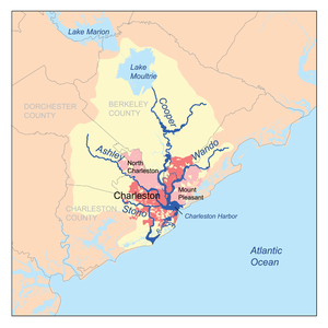
. These cities are located along the river, Mt. Pleasant, Charleston
Charleston, South Carolina
Charleston is the second largest city in the U.S. state of South Carolina. It was made the county seat of Charleston County in 1901 when Charleston County was founded. The city's original name was Charles Towne in 1670, and it moved to its present location from a location on the west bank of the...
, North Charleston
North Charleston, South Carolina
North Charleston is the 3rd largest city in the U.S. state of South Carolina with incorporated areas in Berkeley, Charleston, and Dorchester counties. On June 12, 1972 the city of North Charleston incorporated and was the 9th largest city in South Carolina. According to the 2010 Census, North...
, Goose Creek
Goose Creek, South Carolina
Goose Creek is a city in Berkeley county in the U.S. state of South Carolina. The population was 35,938 at the 2010 census. Most of the Naval Weapons Station Charleston is in Goose Creek. As defined by the U.S. Office of Management and Budget, and used by the U.S...
and Hanahan
Hanahan, South Carolina
Hanahan is a city in Berkeley County, South Carolina, United States. The population was 12,937 at the 2000 census. Portions of the Naval Weapons Station Charleston, including the Naval Consolidated Brig Charleston, are located in Hanahan. As defined by the U.S. Office of Management and Budget, and...
. Short and wide, it is joined first by the blackwater
Blackwater river
A blackwater river is a river with a deep, slow-moving channel that flows through forested swamps and wetlands. As vegetation decays in the water, tannins are leached out, resulting in transparent, acidic water that is darkly stained, resembling tea or coffee. Most major blackwater rivers are in...
East Branch, then farther downstream, the tidal Wando River
Wando River
The Wando River is a tidewater river in the coastal area of South Carolina. It begins in the town of Awendaw and empties into the Cooper River at Charleston Harbor. Its drainage area is . -External links:...
. Almost immediately thereafter, the river widens into its estuary
Estuary
An estuary is a partly enclosed coastal body of water with one or more rivers or streams flowing into it, and with a free connection to the open sea....
, uniting with the Ashley River
Ashley River (South Carolina)
The Ashley River is a blackwater / tidal river in South Carolina, rising from the Wassamassaw and Great Cypress Swamps in western Berkeley County. It consolidates its main channel about five miles west of Summerville, widening into a tidal estuary just south of Fort Dorchester...
to form the Charleston Harbor (then, as locals like to say, the Atlantic Ocean).
Long utilized as an important commercial waterway, the West Branch of the Cooper River was initially connected to the Santee River
Santee River
The Santee River is a river in South Carolina in the United States, long. The Santee and its tributaries provide the principal drainage and navigation for the central coastal plain of South Carolina, emptying into the Atlantic Ocean approximately from its farthest headwater on the Catawba River...
near its navigation head by a canal built in the late 18th century. Though the West Branch still rises as a blackwater swamp in central Berkeley County, its main headwaters have been seamlessly shifted to Lake Moultrie
Lake Moultrie
Lake Moultrie is the third largest lake in South Carolina covering over .-Location:Lake Moultrie is located in Berkeley County, South Carolina, is fed by Lake Marion through a diversion canal. Nearby towns include Moncks Corner, Bonneau and St. Stephen....
by the 1940s vintage Tail Race Canal. Lake Moultrie
Lake Moultrie
Lake Moultrie is the third largest lake in South Carolina covering over .-Location:Lake Moultrie is located in Berkeley County, South Carolina, is fed by Lake Marion through a diversion canal. Nearby towns include Moncks Corner, Bonneau and St. Stephen....
is, in turn, fed from Lake Marion
Lake Marion (South Carolina)
Lake Marion is the largest lake in South Carolina, centrally located and with territory within five counties. The lake is referred to as South Carolina's inland sea. It has a shoreline and covers nearly 110,000 acres of rolling farmlands, former marshes, and river valley landscape...
by a diversion canal built around the same time period. This artificial rerouting of the Cooper River basin has essentially unified the Santee and Cooper River systems into a single hydrological drainage entity.
The river was named for Anthony Ashley Cooper, 1st Earl of Shaftesbury
Anthony Ashley Cooper, 1st Earl of Shaftesbury
Anthony Ashley Cooper, 1st Earl of Shaftesbury PC , known as Anthony Ashley Cooper from 1621 to 1631, as Sir Anthony Ashley Cooper, 2nd Baronet from 1631 to 1661, and as The Lord Ashley from 1661 to 1672, was a prominent English politician during the Interregnum and during the reign of King Charles...
and chief Lord Proprietor of the Carolina Colony. Charleston was founded on the western bank of the Ashley River in 1670 (at Charles Towne Landing
Charles Towne Landing
Charles Towne Landing is a park at the original site of the first permanent English settlement in South Carolina. Originally opened in 1970 to commemorate Charleston, South Carolina's tricentennial, this state park showcases animals indigenous to the state in 1670, with exhibits designed by...
), before moving across to its current peninsular location ten years later.
Motorists have been able to cross the Cooper River under their own power for approximately eight decades, when it was first spanned by the John P. Grace Memorial Bridge
John P. Grace Memorial Bridge
The John P. Grace Memorial Bridge, or the Cooper River Bridge as it was familiarly known, was a cantilever bridge that crossed the Cooper River in Charleston, South Carolina. It opened on August 8, 1929 and was built by the Cooper River Bridge Company. Shortridge Hardesty of Waddell & Hardesty,...
. As the Grace Bridge quickly became both functionally and structurally deficient, the State of South Carolina built a parallel span, the Silas N. Pearman Bridge, a few meters to the south in 1966. These highly overstressed spans were, for over a quarter of a century, the only connection between Charleston and the rapidly growing suburb of Mt. Pleasant
Mount Pleasant, South Carolina
Mount Pleasant is a large affluent suburban town in Charleston County, South Carolina, United States. It is a member of the Charleston–North Charleston–Summerville Metropolitan Statistical Area, for statistical purpose only, as designated by the U.S. Office of Management and Budget....
until the Don Holt Bridge, built a few miles upriver as part of the I-526 corridor, became the third bridge to span the river in 1992.
In service since August 8, 1929, the Grace Memorial Bridge was the oldest of the three. Named for the commissioner who inspired the state's highway system, the Pearman Bridge opened on April 29, 1966. Their replacement span, the cable-stayed Arthur Ravenel, Jr. Bridge
Arthur Ravenel, Jr. Bridge
The Arthur Ravenel Jr. Bridge, also known as the New Cooper River Bridge, is a cable-stayed bridge over the Cooper River in South Carolina, connecting downtown Charleston to Mount Pleasant. The eight lane bridge satisfied the capacity of U.S. Route 17 when it opened in 2005 to replace two obsolete...
(or New Cooper River Bridge) opened to traffic on July 16, 2005. Demolition of the Grace and Pearman bridges began shortly afterwards and was completed in late 2007. Though both are modern in every respect, there are currently only two bridges left to carry vehicular traffic across the river: the Holt and Ravenel bridges.
A very popular 10k run over the river occurs each spring, the Cooper River Bridge Run and Walk.
Daniel Island
Daniel Island
Daniel Island is a island located in the City of Charleston, South Carolina . It is located in Berkely County and situated between the Cooper and Wando Rivers...
and Drum Island (uninhabited) are adjacent to the river. Cargo terminals, a paper mill, and the former Charleston Navy Base line its shore. Rice and indigo
Indigo
Indigo is a color named after the purple dye derived from the plant Indigofera tinctoria and related species. The color is placed on the electromagnetic spectrum between about 420 and 450 nm in wavelength, placing it between blue and violet...
were heavily cultivated on plantations surrounding the brackish marshland of the lower Cooper River from the early Colonial through the end of the Civil War
American Civil War
The American Civil War was a civil war fought in the United States of America. In response to the election of Abraham Lincoln as President of the United States, 11 southern slave states declared their secession from the United States and formed the Confederate States of America ; the other 25...
periods. The Patriot's Point
Patriot's Point
Patriots Point Naval & Maritime Museum is located in Mount Pleasant, South Carolina, at the mouth of the Cooper River on the Charleston Harbor, across from Charleston.-Museum ships and exhibits:...
naval & maritime museum sits at the mouth of the river. Berthed at Patriot's Point are four museum ship
Museum ship
A museum ship, or sometimes memorial ship, is a ship that has been preserved and converted into a museum open to the public, for educational or memorial purposes...
s, most notably the USS Yorktown
USS Yorktown (CV-10)
USS Yorktown is one of 24 s built during World War II for the United States Navy. She is named after the Battle of Yorktown of the American Revolutionary War, and is the fourth U.S. Navy ship to bear the name...
, a World War II aircraft carrier
Aircraft carrier
An aircraft carrier is a warship designed with a primary mission of deploying and recovering aircraft, acting as a seagoing airbase. Aircraft carriers thus allow a naval force to project air power worldwide without having to depend on local bases for staging aircraft operations...
.
“Goose Creek” A tributary of the Cooper River was the site of a U.S. Navy submarine base
Submarine base
A submarine base is a military base that shelters submarines and their personnel.Examples of present-day submarine bases include HMNB Clyde, Île Longue , Naval Submarine Base Kings Bay, Naval Submarine Base New London, and Rybachiy Nuclear Submarine Base .The Israeli navy bases its growing submarine...
through the late 90’s and functioned as a nuclear weapons handling facility servicing FBM (Fleet Ballistic Submarines) until the advent of the larger Trident Class which required a deeper draft.