

Rondout Creek
Encyclopedia
Rondout Creek is a 63.3 miles (101.9 km) tributary
of the Hudson River
in Ulster
and Sullivan
counties, New York
, USA. It rises on Rocky Mountain
in the eastern Catskills
, flows south into Rondout Reservoir
, part of New York City
's water supply network, then into the valley between the Catskills and the Shawangunk Ridge
, where it goes over the spectacular High Falls
and finally out to the Hudson at Kingston
, receiving along the way the Wallkill River
.
The name of Rondout Creek comes from the fort, or redoubt, that was erected near its mouth. The Dutch
equivalent of the English word redoubt (meaning a fort or stronghold) is reduyt. In the Dutch records of Wildwyck, however, the spelling used to designate this same fort is invariably Ronduyt during the earliest period, with the present form rondout (often capitalized) appearing as early as November 22, 1666.
It became economically important in the 19th century when the Delaware and Hudson Canal
followed closely alongside it from Napanoch
to the village of Rondout
, now part of Kingston, which grew rapidly as the canal's northern port. Today it is important not only for the reservoir, but for the fishing
and other recreational opportunities it provides.
Due to the Wallkill, it drains a vast area stretching over 1100 square miles (2,849 km²) all the way down to Sussex County, New Jersey
. The high mountains around its upper course and the reservoir, which collects water from three others, also add to its flow.
North of the Shawangunks
, where the Wallkill trickles down from Sturgeon Pool, it is wide enough to be referred to as the Rondout River at some points. At Creeklocks, the former northern outlet of the canal, it becomes wide and deep enough to be navigable
, and several marina
s line the banks of the stream, now more than 100 feet (30.5 m) wide, at Kingston just above its mouth.
between Rocky Mountain and Balsam Cap, Rondout Creek flows generally southerly down the slopes of Rocky Mountain into a narrow valley, receiving tributary Picket Brook on the left and three unnamed streams from the slopes of Peekamoose Mountain
to the right. A mile or two from its source, it reaches some private lands and its first road, Peekamoose Road (Ulster County 42). It has dropped 1440 feet (438.9 m) in its first two miles. It turns to the southwest to follow a wider valley, known informally as Peekamoose Gorge. Most of the land surrounding the creek is part of New York's Forest Preserve
, "forever wild" and thus undeveloped. The rocky stream boasts several popular swimming hole
s, one of which is known as Blue Hole for the greenish tone of the deep water within. South of the small outlet stream from Peekamoose Lake, it is crossed and then followed by Peekamoose Road, which at first runs high above the creek but then close by it.
Along here it receives several tributaries from the right — Buttermilk Falls Brook, with its eponymous waterfall near its mouth, High Falls Brook and Bear Hole Brook — most of them rising, like the Rondout itself, in the Slide Mountain Wilderness Area
to the west. To the east is another Forest Preserve management unit, the Sundown Wild Forest. Some unnamed tributaries come from here. Because of the protected area
s on both sides of the creek and the ease of public access, this area has become one of the Catskills' popular trout
streams, and fly-fishermen
can be seen here during the season.
It crosses under Peekamoose Road, here also carrying the Long Path
hiking trail, again just north of a popular camping area in the small Peekamoose Wild Forest, and then passes the hamlet of Sundown
and widens slightly as a floodplain
develops alongside. The land along the creek is now largely in private hands, and there is little public access to it as it crosses into Sullivan County
.
, it widens into the reservoir just below Grahamsville
and begins flowing more to the east-southeast. Routes 55
and 55A bracket the reservoir to the south and north respectively. One-third of the way along the reservoir's 9 miles (14.5 km) length, it crosses back into Ulster County. Now at an elevation of 840 feet (256 m), the creek resumes at the site of the former hamlet of Lackawack, leaving the Catskill Park, now headed eastwards, in a rocky, wider streambed through some slightly more development.
It follows closely alongside Route 55, deviating from it only when it turns north to Honk Lake, another impoundment. Past here it crosses under 55 again and comes into Napanoch
. After crossing under US 209 and receiving the Ver Nooy Kill it bends northeast, paralleling the Shawangunk Ridge
and the edge of the Catskill Plateau.
, where the first remnant of the canal, an empty ditch next to an old railroad station, can be found alongside. The creek continues towards Kerhonkson
, where Route 55 and US 44
cross over. US 209 continues paralleling the Rondout towards High Falls
, as it begins to curve to the east around the northern end of the ridge.
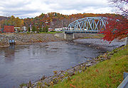
Here, it goes over the spectacular waterfall
that gives the community its name, just below NY 213
. These have been the subject of much controversy in recent years, since they are considered both a popular swimming hole and an attractive nuisance
. The local fire department
, which owned the land, had to sell it to keep its liability insurance
premium
s affordable, and the new owner has posted the property for the same reason. However, swimmers routinely descend on the area on warm days.
 Around the north end of the Shawangunks, it receives as tributaries many of the streams of the Minnewaska State Preserve: Peters Kill, Stony Kill and Coxing Kill. It begins to curve more to the east again. Route 213 replaces Route 209 as the Rondout's paralleling road, with the canal's empty ditch running next to both along the way to Rosendale
, the next settlement, which grew up around the canal and, later, a local cement industry that used the creek to get its product to market.
Here it crosses under Route 213 and NY 32
in a gravel-lined flood control channel, but returns to a more natural bed shortly afterwards to flow beneath the New York State Thruway
. In the wooded areas east of the Thruway, the Wallkill River
, its flow attenuated by Sturgeon Pool
just upriver, joins in from the south. The Rondout turns north, then east again, crossing Route 213 again. At Creeklocks the last lock and the end of the canal are still visible.
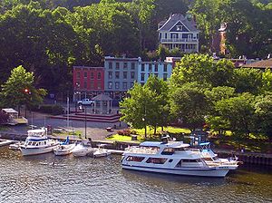
 In Kingston itself it widens and flows under a pair of bridges, the historic Kingston–Port Ewen Suspension Bridge, which carried US 9W
until the construction of the neighboring John T. Loughran Bridge
. The city's West Strand neighborhood along the waterfront has been rejuvenated in recent years and many boats can be seen moored at docks here on summer weekends. Old shipbuilders
' factories line the northern bank, and one of them has been converted into the Hudson River Maritime Museum
. After a slight curve through swampier, less developed lowlands in the Kingston Point neighborhood, the Rondout empties into the Hudson at Rondout Lighthouse, just opposite Rhinecliff.
realized the value of the creek for their colonial ambitions, and established a trading post
in the early 17th century, to deal with the local Native Americans
, who likewise frequented the area. In 1652, an Englishman
, Thomas Chambers, became the first permanent inhabitant at the site, the genesis of present-day Kingston. Unlike the Esopus
, the Rondout played only a minimal role in the area's early settlement, since the northerly creek was navigable for a greater distance inland and had more farmland on its banks.
 Settlement did slowly progress inland, but it was not until well after American independence that the Rondout would become economically important. In the early 1820s two Philadelphia businessmen realized the immense profits that could be made if they could find a way to get the mostly unmined high-quality anthracite coal from undeveloped Northeastern Pennsylvania
to the lucrative markets of New York City
. Railroads had not yet been perfected, so they saw the possibility of a canal running from Honesdale, Pennsylvania
to the Hudson at what was then the village of Rondout
. In 1828 they obtained a charter for their company to do this, and the Delaware and Hudson Canal
was opened a few years later. Coal was transferred from canal barge
s to river ships at Rondout, and it became a boomtown quickly. The canal remained a prosperous operation until late in the 19th century when rail transportation finally became more affordable, and ended its days in 1904 after a brief period carrying Rosendale cement. The former terminal port area for the canal is now Kingston's Rondout-West Strand Historic District
, listed on the National Register of Historic Places
.
had anticipated it when he explored the upper headwaters with a friend early in the century, writing in his essay "A Bed of Boughs" of the purity of the stream's waters and its benefits for both man and fish:
Starting in 1915 with Ashokan Reservoir
, New York City had been expanding its water supply system with reservoirs in the Catskills. In 1937 it began construction of Merriman Dam near Lackawack, which would soon be flooded forever to allow the growing city to tap the pure waters Burroughs had written about. Those waters began to reach city taps in 1951, and the reservoir itself was completed three years later. Today, via the Delaware Aqueduct
, and the connections it has via the Neversink Aqueduct to the Neversink
, Pepacton
and Cannonsville
reservoirs to the west supplementing the upper Rondout's drainage, it supplies half the city's daily water draw.
Tributary
A tributary or affluent is a stream or river that flows into a main stem river or a lake. A tributary does not flow directly into a sea or ocean...
of the Hudson River
Hudson River
The Hudson is a river that flows from north to south through eastern New York. The highest official source is at Lake Tear of the Clouds, on the slopes of Mount Marcy in the Adirondack Mountains. The river itself officially begins in Henderson Lake in Newcomb, New York...
in Ulster
Ulster County, New York
Ulster County is a county located in the state of New York, USA. It sits in the state's Mid-Hudson Region of the Hudson Valley. As of the 2010 census, the population was 182,493. Recent population estimates completed by the United States Census Bureau for the 12-month period ending July 1 are at...
and Sullivan
Sullivan County, New York
Sullivan County is a county located in the U.S. state of New York. As of the 2010 census, the population was 77,547. The county seat is Monticello. The name is in honor of Major General John Sullivan, who was a hero in the American Revolutionary War...
counties, New York
New York
New York is a state in the Northeastern region of the United States. It is the nation's third most populous state. New York is bordered by New Jersey and Pennsylvania to the south, and by Connecticut, Massachusetts and Vermont to the east...
, USA. It rises on Rocky Mountain
Rocky Mountain (Ulster County, New York)
Rocky Mountain is a mountain located in Ulster County, New York.The mountain is part of the Catskill Mountains.Rocky Mountain is flanked to the west by Lone Mountain, and to the northeast by Balsam Cap....
in the eastern Catskills
Catskill Mountains
The Catskill Mountains, an area in New York State northwest of New York City and southwest of Albany, are a mature dissected plateau, an uplifted region that was subsequently eroded into sharp relief. They are an eastward continuation, and the highest representation, of the Allegheny Plateau...
, flows south into Rondout Reservoir
Rondout Reservoir
Rondout Reservoir is part of New York City's water supply network. It is located 75 miles northwest of the city in the Catskill Mountains, near the southern end of Catskill Park, split between the towns of Wawarsing in Ulster County and Neversink in Sullivan County...
, part of New York City
New York City
New York is the most populous city in the United States and the center of the New York Metropolitan Area, one of the most populous metropolitan areas in the world. New York exerts a significant impact upon global commerce, finance, media, art, fashion, research, technology, education, and...
's water supply network, then into the valley between the Catskills and the Shawangunk Ridge
Shawangunk Ridge
The Shawangunk Ridge , also known as the Shawangunk Mountains or The Gunks, is a ridge of bedrock in Ulster County, Sullivan County and Orange County in the state of New York, extending from the northernmost point of New Jersey to the Catskill Mountains.The ridgetop, which widens considerably at...
, where it goes over the spectacular High Falls
High Falls, New York
High Falls is a hamlet in Ulster County, New York, United States. The population was 627 at the 2000 census.High Falls is located in Marbletown, near the town boundary with Rosendale.-Geography:...
and finally out to the Hudson at Kingston
Kingston, New York
Kingston is a city in and the county seat of Ulster County, New York, USA. It is north of New York City and south of Albany. It became New York's first capital in 1777, and was burned by the British Oct. 16, 1777, after the Battles of Saratoga...
, receiving along the way the Wallkill River
Wallkill River
The Wallkill River, a tributary of the Hudson, drains Lake Mohawk in Sparta, New Jersey, flowing from there generally northeasterly to Rondout Creek in New York, near Rosendale, with the combined flows reaching the Hudson at Kingston....
.
The name of Rondout Creek comes from the fort, or redoubt, that was erected near its mouth. The Dutch
Dutch language
Dutch is a West Germanic language and the native language of the majority of the population of the Netherlands, Belgium, and Suriname, the three member states of the Dutch Language Union. Most speakers live in the European Union, where it is a first language for about 23 million and a second...
equivalent of the English word redoubt (meaning a fort or stronghold) is reduyt. In the Dutch records of Wildwyck, however, the spelling used to designate this same fort is invariably Ronduyt during the earliest period, with the present form rondout (often capitalized) appearing as early as November 22, 1666.
It became economically important in the 19th century when the Delaware and Hudson Canal
Delaware and Hudson Canal
The Delaware and Hudson Canal was the first venture of the Delaware and Hudson Canal Company, which later developed the Delaware and Hudson Railway...
followed closely alongside it from Napanoch
Napanoch, New York
Napanoch is a hamlet in Ulster County, New York. It is at the junction of routes 209 and 55. It is on the Shawangunk Ridge National Scenic Byway, and is part of the Hudson River Valley National Heritage Area....
to the village of Rondout
Rondout, New York
Rondout was a village located on the north side of Rondout Creek near its mouth on the Hudson River in Ulster County and includes the Rondout-West Strand Historic District....
, now part of Kingston, which grew rapidly as the canal's northern port. Today it is important not only for the reservoir, but for the fishing
Angling
Angling is a method of fishing by means of an "angle" . The hook is usually attached to a fishing line and the line is often attached to a fishing rod. Fishing rods are usually fitted with a fishing reel that functions as a mechanism for storing, retrieving and paying out the line. The hook itself...
and other recreational opportunities it provides.
Due to the Wallkill, it drains a vast area stretching over 1100 square miles (2,849 km²) all the way down to Sussex County, New Jersey
Sussex County, New Jersey
The County of Sussex is the northernmost county in the State of New Jersey. It is part of the New York City Metropolitan Area. As of the 2010 Federal decennial census, 149,265 persons resided in Sussex County...
. The high mountains around its upper course and the reservoir, which collects water from three others, also add to its flow.
Course
The Rondout goes through several different stages due to the changes in surrounding geography and past development, such as the canal and reservoir, that has drawn on its waters. Its headwaters, above the reservoir, are a typical mountain stream. Below the reservoir it remains fairly rocky but widens into the floor of a narrow valley. At Napanoch, where it turns northeast and receives its first significant tributary, the Ver Nooy Kill, it becomes wider, as does the valley it drains, and deeper.North of the Shawangunks
Shawangunk Ridge
The Shawangunk Ridge , also known as the Shawangunk Mountains or The Gunks, is a ridge of bedrock in Ulster County, Sullivan County and Orange County in the state of New York, extending from the northernmost point of New Jersey to the Catskill Mountains.The ridgetop, which widens considerably at...
, where the Wallkill trickles down from Sturgeon Pool, it is wide enough to be referred to as the Rondout River at some points. At Creeklocks, the former northern outlet of the canal, it becomes wide and deep enough to be navigable
Navigation
Navigation is the process of monitoring and controlling the movement of a craft or vehicle from one place to another. It is also the term of art used for the specialized knowledge used by navigators to perform navigation tasks...
, and several marina
Marina
A marina is a dock or basin with moorings and supplies for yachts and small boats.A marina differs from a port in that a marina does not handle large passenger ships or cargo from freighters....
s line the banks of the stream, now more than 100 feet (30.5 m) wide, at Kingston just above its mouth.
Catskills and headwaters
Rising below the colMountain pass
A mountain pass is a route through a mountain range or over a ridge. If following the lowest possible route, a pass is locally the highest point on that route...
between Rocky Mountain and Balsam Cap, Rondout Creek flows generally southerly down the slopes of Rocky Mountain into a narrow valley, receiving tributary Picket Brook on the left and three unnamed streams from the slopes of Peekamoose Mountain
Peekamoose Mountain
Peekamoose Mountain is a mountain located in Ulster County, New York.The mountain is part of the Catskill Mountains.Peekamoose Mountain is flanked to the north by Table Mountain....
to the right. A mile or two from its source, it reaches some private lands and its first road, Peekamoose Road (Ulster County 42). It has dropped 1440 feet (438.9 m) in its first two miles. It turns to the southwest to follow a wider valley, known informally as Peekamoose Gorge. Most of the land surrounding the creek is part of New York's Forest Preserve
Forest Preserve (New York)
New York's Forest Preserve is all the land owned by the state within the Adirondack and Catskill parks, managed by its Department of Environmental Conservation. These properties are required to be kept "forever wild" by Article 14 of the state constitution, and thus enjoy the highest degree of...
, "forever wild" and thus undeveloped. The rocky stream boasts several popular swimming hole
Swimming hole
A swimming hole is a place in a river, stream, creek, spring, or similar natural body of water, which is large enough and deep enough for a person to swim in...
s, one of which is known as Blue Hole for the greenish tone of the deep water within. South of the small outlet stream from Peekamoose Lake, it is crossed and then followed by Peekamoose Road, which at first runs high above the creek but then close by it.
Along here it receives several tributaries from the right — Buttermilk Falls Brook, with its eponymous waterfall near its mouth, High Falls Brook and Bear Hole Brook — most of them rising, like the Rondout itself, in the Slide Mountain Wilderness Area
Slide Mountain Wilderness Area
The Slide Mountain Wilderness Area is, at 47,500 acres , the largest tract of state-owned Forest Preserve in New York's Catskill Park, and the largest area under any kind of wilderness area protection between the Adirondacks and the southern Appalachians...
to the west. To the east is another Forest Preserve management unit, the Sundown Wild Forest. Some unnamed tributaries come from here. Because of the protected area
Protected area
Protected areas are locations which receive protection because of their recognised natural, ecological and/or cultural values. There are several kinds of protected areas, which vary by level of protection depending on the enabling laws of each country or the regulations of the international...
s on both sides of the creek and the ease of public access, this area has become one of the Catskills' popular trout
Trout
Trout is the name for a number of species of freshwater and saltwater fish belonging to the Salmoninae subfamily of the family Salmonidae. Salmon belong to the same family as trout. Most salmon species spend almost all their lives in salt water...
streams, and fly-fishermen
Fly fishing
Fly fishing is an angling method in which an artificial 'fly' is used to catch fish. The fly is cast using a fly rod, reel, and specialized weighted line. Casting a nearly weightless fly or 'lure' requires casting techniques significantly different from other forms of casting...
can be seen here during the season.
It crosses under Peekamoose Road, here also carrying the Long Path
Long Path
The Long Path is a long-distance hiking trail beginning at the George Washington Bridge in Fort Lee, New Jersey and currently ending at Altamont, New York, in the Albany area...
hiking trail, again just north of a popular camping area in the small Peekamoose Wild Forest, and then passes the hamlet of Sundown
Sundown, New York
Sundown is a hamlet located within Denning, New York, in Ulster County, New York, United States. It is 34.6 miles from the city of Kingston, New York and 119 miles from New York City. Sundown is near the south town line of Denning on Route 46....
and widens slightly as a floodplain
Floodplain
A floodplain, or flood plain, is a flat or nearly flat land adjacent a stream or river that stretches from the banks of its channel to the base of the enclosing valley walls and experiences flooding during periods of high discharge...
develops alongside. The land along the creek is now largely in private hands, and there is little public access to it as it crosses into Sullivan County
Sullivan County, New York
Sullivan County is a county located in the U.S. state of New York. As of the 2010 census, the population was 77,547. The county seat is Monticello. The name is in honor of Major General John Sullivan, who was a hero in the American Revolutionary War...
.
Reservoir to Napanoch
After crossing under NY 55ANew York State Route 55A
New York State Route 55A is a state highway located in Sullivan and Ulster counties. It is a loop route connected to NY 55 at both ends, near Grahamsville in the west and Napanoch in the east...
, it widens into the reservoir just below Grahamsville
Grahamsville, New York
Grahamsville is an unincorporated hamlet at the junction of NY 42 and 55 in the Town of Neversink, in Sullivan County, New York, USA. It is near the western end of Rondout Reservoir, and is the southernmost community in the Catskill Park...
and begins flowing more to the east-southeast. Routes 55
New York State Route 55
New York State Route 55 is a state highway in southern New York, running from the Pennsylvania state line at the Delaware River in Barryville to the Connecticut state line at Wingdale...
and 55A bracket the reservoir to the south and north respectively. One-third of the way along the reservoir's 9 miles (14.5 km) length, it crosses back into Ulster County. Now at an elevation of 840 feet (256 m), the creek resumes at the site of the former hamlet of Lackawack, leaving the Catskill Park, now headed eastwards, in a rocky, wider streambed through some slightly more development.
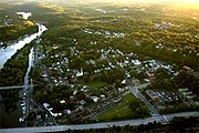
It follows closely alongside Route 55, deviating from it only when it turns north to Honk Lake, another impoundment. Past here it crosses under 55 again and comes into Napanoch
Napanoch, New York
Napanoch is a hamlet in Ulster County, New York. It is at the junction of routes 209 and 55. It is on the Shawangunk Ridge National Scenic Byway, and is part of the Hudson River Valley National Heritage Area....
. After crossing under US 209 and receiving the Ver Nooy Kill it bends northeast, paralleling the Shawangunk Ridge
Shawangunk Ridge
The Shawangunk Ridge , also known as the Shawangunk Mountains or The Gunks, is a ridge of bedrock in Ulster County, Sullivan County and Orange County in the state of New York, extending from the northernmost point of New Jersey to the Catskill Mountains.The ridgetop, which widens considerably at...
and the edge of the Catskill Plateau.
Rondout Valley
The creek, here wider and deeper, forms the bed of a widening valley as it continues northeast past Eastern Correctional FacilityEastern Correctional Facility
The Eastern Correctional Facility is a maximum security prison in New York in the USA. The prison is in Ulster County, New York. The prison was at one time called the "State Institution for Male Defective Delinquents". The Delaware and Hudson Canal, and later the New York, Ontario and Western...
, where the first remnant of the canal, an empty ditch next to an old railroad station, can be found alongside. The creek continues towards Kerhonkson
Kerhonkson, New York
Kerhonkson is a hamlet in Ulster County, New York, United States. The population was 1,684 at the 2010 census.Kerhonkson is a small hamlet which, along with Accord, makes up the Town of Rochester on US 209, just south of the town's boundary with the Town of Wawarsing and just north of where US 44...
, where Route 55 and US 44
U.S. Route 44
U.S. Route 44 is an east–west United States highway that runs for 237 miles through four states in the Northeastern region of the United States. The western terminus is at U.S. Route 209 and New York State Route 55 in Kerhonkson, a hamlet in the Hudson Valley region of New York...
cross over. US 209 continues paralleling the Rondout towards High Falls
High Falls, New York
High Falls is a hamlet in Ulster County, New York, United States. The population was 627 at the 2000 census.High Falls is located in Marbletown, near the town boundary with Rosendale.-Geography:...
, as it begins to curve to the east around the northern end of the ridge.
Here, it goes over the spectacular waterfall
Waterfall
A waterfall is a place where flowing water rapidly drops in elevation as it flows over a steep region or a cliff.-Formation:Waterfalls are commonly formed when a river is young. At these times the channel is often narrow and deep. When the river courses over resistant bedrock, erosion happens...
that gives the community its name, just below NY 213
New York State Route 213
New York State Route 213 is a state highway located entirely in Ulster County. It runs from the eastern Catskills to downtown Kingston....
. These have been the subject of much controversy in recent years, since they are considered both a popular swimming hole and an attractive nuisance
Attractive Nuisance
Attractive Nuisance, released in 2000, is The Loud Family's fifth full length album. It featured the same line-up as on 1998's Days for Days...
. The local fire department
Fire department
A fire department or fire brigade is a public or private organization that provides fire protection for a certain jurisdiction, which typically is a municipality, county, or fire protection district...
, which owned the land, had to sell it to keep its liability insurance
Liability insurance
Liability insurance is a part of the general insurance system of risk financing to protect the purchaser from the risks of liabilities imposed by lawsuits and similar claims. It protects the insured in the event he or she is sued for claims that come within the coverage of the insurance policy...
premium
Premium
Premium may refer to:* Premium , a promotional item that can be received for a small fee when redeeming proofs of purchase that come with or on retail products....
s affordable, and the new owner has posted the property for the same reason. However, swimmers routinely descend on the area on warm days.
Lower Rondout and Kingston
Rosendale Village, New York
Rosendale Village is a hamlet and census-designated place within the town of Rosendale in Ulster County, New York, United States, with a population of roughly 1,500 people...
, the next settlement, which grew up around the canal and, later, a local cement industry that used the creek to get its product to market.
Here it crosses under Route 213 and NY 32
New York State Route 32
New York State Route 32 is a north–south state highway that extends for through the Hudson Valley and Capital District regions of the U.S. state of New York. It is a two-lane surface road for nearly its entire length, with few divided and no limited-access sections. From Harriman to Albany,...
in a gravel-lined flood control channel, but returns to a more natural bed shortly afterwards to flow beneath the New York State Thruway
New York State Thruway
The New York State Thruway is a system of limited-access highways located within the state of New York in the United States. The system, known officially as the Governor Thomas E. Dewey Thruway for former New York Governor Thomas E. Dewey, is operated by the New York State Thruway Authority and...
. In the wooded areas east of the Thruway, the Wallkill River
Wallkill River
The Wallkill River, a tributary of the Hudson, drains Lake Mohawk in Sparta, New Jersey, flowing from there generally northeasterly to Rondout Creek in New York, near Rosendale, with the combined flows reaching the Hudson at Kingston....
, its flow attenuated by Sturgeon Pool
Sturgeon Pool
Sturgeon Pool is a reservoir near the hamlet of Rifton, in the Town of Esopus in Ulster County, New York.It was created by damming the Wallkill River just above its confluence with Rondout Creek for hydroelectricity ....
just upriver, joins in from the south. The Rondout turns north, then east again, crossing Route 213 again. At Creeklocks the last lock and the end of the canal are still visible.
U.S. Route 9W
U.S. Route 9W is a north–south U.S. Highway in the states of New Jersey and New York. It begins on Fletcher Avenue in Fort Lee, New Jersey as it crosses the US 1 & 9, US 46, and the Interstate 95 approaches to the George Washington Bridge, where it heads north up the west...
until the construction of the neighboring John T. Loughran Bridge
John T. Loughran Bridge
The John T. Loughran Bridge carries US 9W over Rondout Creek between Kingston and Port Ewen, New York, USA. It also crosses over Ferry Street on the Kingston side. It is located just downriver from the historic Kingston-Port Ewen Suspension Bridge, which carried 9W until the Loughran Bridge was...
. The city's West Strand neighborhood along the waterfront has been rejuvenated in recent years and many boats can be seen moored at docks here on summer weekends. Old shipbuilders
Shipbuilding
Shipbuilding is the construction of ships and floating vessels. It normally takes place in a specialized facility known as a shipyard. Shipbuilders, also called shipwrights, follow a specialized occupation that traces its roots to before recorded history.Shipbuilding and ship repairs, both...
' factories line the northern bank, and one of them has been converted into the Hudson River Maritime Museum
Hudson River Maritime Museum
The Hudson River Maritime Museum is a maritime museum dedicated to the Hudson River.It is located at 50 Rondout Landing at the foot of Broadway in Kingston, New York, USA, along Rondout Creek in the city's old waterfront, just east of the John T...
. After a slight curve through swampier, less developed lowlands in the Kingston Point neighborhood, the Rondout empties into the Hudson at Rondout Lighthouse, just opposite Rhinecliff.
Colonial era
The early Dutch settlersDutch colonization of the Americas
Dutch trading posts and plantations in the Americas precede the much wider known colonization activities of the Dutch in Asia. Whereas the first Dutch fort in Asia was built in 1600 , the first forts and settlements on the Essequibo river in Guyana and on the Amazon date from the 1590s...
realized the value of the creek for their colonial ambitions, and established a trading post
Trading post
A trading post was a place or establishment in historic Northern America where the trading of goods took place. The preferred travel route to a trading post or between trading posts, was known as a trade route....
in the early 17th century, to deal with the local Native Americans
Native Americans in the United States
Native Americans in the United States are the indigenous peoples in North America within the boundaries of the present-day continental United States, parts of Alaska, and the island state of Hawaii. They are composed of numerous, distinct tribes, states, and ethnic groups, many of which survive as...
, who likewise frequented the area. In 1652, an Englishman
British colonization of the Americas
British colonization of the Americas began in 1607 in Jamestown, Virginia and reached its peak when colonies had been established throughout the Americas...
, Thomas Chambers, became the first permanent inhabitant at the site, the genesis of present-day Kingston. Unlike the Esopus
Esopus Creek
Esopus Creek is a tributary of the Hudson River that drains the east-central Catskill Mountains of the U.S. state of New York. From its source at Winnisook Lake on the slopes of Slide Mountain, the Catskills' highest peak, it flows across Ulster County to the Hudson at Saugerties. Many tributaries...
, the Rondout played only a minimal role in the area's early settlement, since the northerly creek was navigable for a greater distance inland and had more farmland on its banks.
Canal era
Northeastern Pennsylvania
Northeastern Pennsylvania is a geographic region of Pennsylvania that includes the Pocono Mountains, the Endless Mountains and the industrial cities of Scranton, Wilkes-Barre, Pittston, Hazleton and Carbondale....
to the lucrative markets of New York City
New York City
New York is the most populous city in the United States and the center of the New York Metropolitan Area, one of the most populous metropolitan areas in the world. New York exerts a significant impact upon global commerce, finance, media, art, fashion, research, technology, education, and...
. Railroads had not yet been perfected, so they saw the possibility of a canal running from Honesdale, Pennsylvania
Honesdale, Pennsylvania
Honesdale is a borough in and the county seat of Wayne County, Pennsylvania, United States. It is located northeast of Scranton. The population was 4,874 at the 2000 census....
to the Hudson at what was then the village of Rondout
Rondout, New York
Rondout was a village located on the north side of Rondout Creek near its mouth on the Hudson River in Ulster County and includes the Rondout-West Strand Historic District....
. In 1828 they obtained a charter for their company to do this, and the Delaware and Hudson Canal
Delaware and Hudson Canal
The Delaware and Hudson Canal was the first venture of the Delaware and Hudson Canal Company, which later developed the Delaware and Hudson Railway...
was opened a few years later. Coal was transferred from canal barge
Barge
A barge is a flat-bottomed boat, built mainly for river and canal transport of heavy goods. Some barges are not self-propelled and need to be towed by tugboats or pushed by towboats...
s to river ships at Rondout, and it became a boomtown quickly. The canal remained a prosperous operation until late in the 19th century when rail transportation finally became more affordable, and ended its days in 1904 after a brief period carrying Rosendale cement. The former terminal port area for the canal is now Kingston's Rondout-West Strand Historic District
Rondout-West Strand Historic District
SEE ALSO Rondout, New YorkThe Rondout–West Strand Historic District is a historic district located on the shore of Rondout Creek along the southern boundary of the city of Kingston, New York, USA...
, listed on the National Register of Historic Places
National Register of Historic Places
The National Register of Historic Places is the United States government's official list of districts, sites, buildings, structures, and objects deemed worthy of preservation...
.
Reservoir era
In the mid-20th century, the stream would find another important use. Naturalist John BurroughsJohn Burroughs
John Burroughs was an American naturalist and essayist important in the evolution of the U.S. conservation movement. According to biographers at the American Memory project at the Library of Congress,...
had anticipated it when he explored the upper headwaters with a friend early in the century, writing in his essay "A Bed of Boughs" of the purity of the stream's waters and its benefits for both man and fish:
Starting in 1915 with Ashokan Reservoir
Ashokan Reservoir
The Ashokan Reservoir is a reservoir in Ulster County, New York, USA. The reservoir is in the eastern end of the Catskill Park, and is one of several reservoirs created to provide the City of New York with water. However, it is one of only two reservoirs in the Catskill Watershed. It is also New...
, New York City had been expanding its water supply system with reservoirs in the Catskills. In 1937 it began construction of Merriman Dam near Lackawack, which would soon be flooded forever to allow the growing city to tap the pure waters Burroughs had written about. Those waters began to reach city taps in 1951, and the reservoir itself was completed three years later. Today, via the Delaware Aqueduct
Delaware Aqueduct
The Delaware Aqueduct is the newest of the New York City aqueducts. It takes water from the Rondout Reservoir through the Chelsea Pump Station, the West Branch Reservoir, and the Kensico Reservoir, ending at the Hillview Reservoir in Yonkers, New York....
, and the connections it has via the Neversink Aqueduct to the Neversink
Neversink Reservoir
Neversink Reservoir is one of several in the Catskill Mountains that supply water to New York City and other communities along its water supply network. It is located in Sullivan County's Town of Neversink, 75 miles northwest of the city....
, Pepacton
Pepacton Reservoir
The Pepacton Reservoir, also known as the Downsville Reservoir or the Downsville Dam, is a reservoir in Delaware County, New York that was formed by impounding over ¼ of the East Branch of the Delaware River...
and Cannonsville
Cannonsville Reservoir
The Cannonsville Reservoir is a reservoir in Delaware County, New York, that was formed by impounding over half of the West Branch of the Delaware River. It is the westernmost of New York City's reservoirs, being at the western portion of the Delaware Watershed. Placed in service in 1964, it is the...
reservoirs to the west supplementing the upper Rondout's drainage, it supplies half the city's daily water draw.
See also
- List of rivers of New York
- List of crossings of Rondout Creek