
Yakima River
Encyclopedia
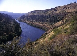
The Yakima River is a tributary of the Columbia River
in south central and eastern Washington State, named for the indigenous Yakama
people. The length of the river from headwaters to mouth is 214 miles (344 km), with an average drop of 9.85 ft/mi.
at an elevation of 2449 feet (746 m) at Keechelus Dam on Keechelus Lake
near Snoqualmie Pass
, northwest of Cle Elum
. The river flows through that town, skirts Ellensburg
, passes the city of Yakima
, and continues southeast to Richland
, where it flows into the Columbia River
at an elevation of 340 feet (103.6 m).
and kayaking
, especially around the Ellensburg area during the summer months. The Yakima River is ranked between Class I and Class II rapids
, depending on the circumstances and season.
on or about October 17, 1805. They stopped briefly at the confluence of the Yakima and the Columbia, although they did not proceed upriver. The river was then known to local Native Americans as 'Tap Teel', although the area has been inhabited since prehistory.
on the north, Rattlesnake Mountain
and the Rattlesnake Hills
on the east, and the Horse Heaven Hills
to the south. The basin encompasses areas designated by the Washington Department of Ecology
as the Upper Yakima Water Resource Inventory Areas (WRIAs) 38 and 39 and the Lower Yakima WRIA 37. The dividing line between these northern and southern sections is the confluence of the Naches
and Yakima Rivers.
The Yakima River provides irrigation
for the dry but fertile land in the valley, and irrigated agriculture is the economic base. Agricultural land totals 1000 square miles (2,590 km²), including irrigated pastures, orchards, grapes, hops, and field crops. A significant portion of Washington apples and cherries are grown in the valley, as well as most (75%) of the United States's hops
. Since the late 20th century, the wine
industry has grown rapidly in the area. It is the location of the Yakima Valley AVA
, a designated American Viticultural Area
.
Major landowners in the valley include federal and state agencies and the Yakama Indian Nation. Private ownership accounts for 1246818 acres (5,045.7 km²). The United States Forest Service
manages 892509 acres (3,611.9 km²), and the Yakama Nation owns 889786 acres (3,600.8 km²) within the basin. Forested areas in the northern and western portions of the basin occupy approximately 2200 square miles (5,698 km²) and are used for recreation, wildlife habitat, timber harvest, grazing, and tribal cultural activities. Range lands comprise about 2900 square miles (7,511 km²) and are used for military training, grazing, wildlife habitat, and tribal cultural activities.
Major population centers include the city of Yakima
and the Tri-Cities
area. Population growth for the 1990s was projected at 7.9% in Kittitas County, 19.7% in Yakima County
, and 22.7% in Benton County
. While much of the growth in Benton and Yakima counties has been in and around the incorporated areas, most of the growth in Kittitas County has been in unincorporated areas.
In addition to irrigated agriculture, the major economic driving forces include timber harvest and processing, cattle, and outdoor recreation. With the significant reduction in timber harvesting on federal lands and the implementation of the Northwest Forest Plan
to protect the endangered Northern Spotted Owl
, the timber economy has been greatly eroded in recent years. The proximity to high population areas of the Puget Sound
has caused a rapid increase in the demand for outdoor recreational experiences in the basin.
statistics for the Yakima River are heavily effected by the irrigation system. The USGS operates four streamflow gages on the Yakima River. The highest average discharge recorded, 3542 cuft/s more than halfway up the river at Union Gap
. The two downriver gages show average flows of a reduced amount.
Columbia River
The Columbia River is the largest river in the Pacific Northwest region of North America. The river rises in the Rocky Mountains of British Columbia, Canada, flows northwest and then south into the U.S. state of Washington, then turns west to form most of the border between Washington and the state...
in south central and eastern Washington State, named for the indigenous Yakama
Yakama
The Confederated Tribes and Bands of the Yakama Nation, or simply Yakama Nation , is a Native American group with nearly 10,000 enrolled members, living in Washington. Their reservation, along the Yakima River, covers an area of approximately 1.2 million acres...
people. The length of the river from headwaters to mouth is 214 miles (344 km), with an average drop of 9.85 ft/mi.
Course
The river rises in the Cascade RangeCascade Range
The Cascade Range is a major mountain range of western North America, extending from southern British Columbia through Washington and Oregon to Northern California. It includes both non-volcanic mountains, such as the North Cascades, and the notable volcanoes known as the High Cascades...
at an elevation of 2449 feet (746 m) at Keechelus Dam on Keechelus Lake
Keechelus Lake
Keechelus Lake is a lake and reservoir in Washington state, USA. It is the source of the Yakima River. Keechelus Lake is the western lake of the three large lakes near Interstate 90 and north of the Yakima River in the Cascade Range, the other two being Kachess Lake and Cle Elum Lake...
near Snoqualmie Pass
Snoqualmie Pass
Snoqualmie Pass is a mountain pass that carries Interstate 90 through the Cascade Range in the U.S. State of Washington. The elevation of the pass summit is , and is on the county line between Kittitas County and King County...
, northwest of Cle Elum
Cle Elum, Washington
Cle Elum is a city in Kittitas County, Washington, United States. The population was 1,872 at the 2010 census. Only an hour and a half's drive from Seattle, Cle Elum is a popular area for camping and outdoor activities.-Early years and industries:...
. The river flows through that town, skirts Ellensburg
Ellensburg, Washington
Ellensburg is a city in, and the county seat of, Kittitas County, Washington, United States. The population was 18,174 at the 2010 census. The population was 18,250 at 2011 Estimate from Office of Financial Management. Ellensburg is located just east of the Cascade Range on I-90 and is known as the...
, passes the city of Yakima
Yakima, Washington
Yakima is an American city southeast of Mount Rainier National Park and the county seat of Yakima County, Washington, United States, and the eighth largest city by population in the state itself. As of the 2010 census, the city had a total population of 91,196 and a metropolitan population of...
, and continues southeast to Richland
Richland, Washington
Richland is a city in Benton County in the southeastern part of the U.S. state of Washington, at the confluence of the Yakima and the Columbia Rivers. As of the 2010 census, the city population was 48,058. April 1, 2011 estimates from the Washington State Office of Financial Management put the...
, where it flows into the Columbia River
Columbia River
The Columbia River is the largest river in the Pacific Northwest region of North America. The river rises in the Rocky Mountains of British Columbia, Canada, flows northwest and then south into the U.S. state of Washington, then turns west to form most of the border between Washington and the state...
at an elevation of 340 feet (103.6 m).
Recreation
The Yakima River is used for raftingRafting
Rafting or white water rafting is a challenging recreational outdoor activity using an inflatable raft to navigate a river or other bodies of water. This is usually done on white water or different degrees of rough water, in order to thrill and excite the raft passengers. The development of this...
and kayaking
Kayaking
Kayaking is the use of a kayak for moving across water. Kayaking and canoeing are also known as paddling. Kayaking is distinguished from canoeing by the sitting position of the paddler and the number of blades on the paddle...
, especially around the Ellensburg area during the summer months. The Yakima River is ranked between Class I and Class II rapids
International Scale of River Difficulty
The International Scale of River Difficulty is a standardized scale used to rate the safety of a stretch of river, or a single rapid. The grade reflects the technical difficulty and skill level required associated with the section of river...
, depending on the circumstances and season.
History
The first western explorers to visit the river were Lewis and ClarkLewis and Clark Expedition
The Lewis and Clark Expedition, or ″Corps of Discovery Expedition" was the first transcontinental expedition to the Pacific Coast by the United States. Commissioned by President Thomas Jefferson and led by two Virginia-born veterans of Indian wars in the Ohio Valley, Meriwether Lewis and William...
on or about October 17, 1805. They stopped briefly at the confluence of the Yakima and the Columbia, although they did not proceed upriver. The river was then known to local Native Americans as 'Tap Teel', although the area has been inhabited since prehistory.
Yakima Valley
The Yakima River Basin consists of approximately 6150 square miles (15,928.4 km²) located in south central Washington State. It is bounded by the Cascade Mountains on the west, the Wenatchee MountainsWenatchee Mountains
The Wenatchee Mountains are a range of mountains in central Washington State, United States of America. A major subrange of the Cascade Range, extending east from the Cascade crest, the Wenatchee Mountains separate the drainage basins of the Yakima River from the Wenatchee River...
on the north, Rattlesnake Mountain
Rattlesnake Mountain, Benton County, Washington
Rattlesnake Mountain is a 3,527 ft windswept treeless sub-alpine ridge overlooking the Hanford nuclear site...
and the Rattlesnake Hills
Rattlesnake Hills
The Rattlesnake Hills is a 16 mile long anticline mountain ridge in Yakima County and Benton County in the U.S. state of Washington. Also known as Rattlesnake Mountain and Rattlesnake Ridge, it should not be confused with the much smaller Rattlesnake Ridge located near the west end of Ahtanum Ridge...
on the east, and the Horse Heaven Hills
Horse Heaven Hills
The Horse Heaven Hills are a long range of high, rolling hills in Klickitat, Yakima, and Benton counties in Washington State located east of Satus Creek and west of the Columbia River between the Yakima River and the Wallula Gap. The hills are an anticline ridge in the Yakima fold belt formed by...
to the south. The basin encompasses areas designated by the Washington Department of Ecology
Washington Department of Ecology
The Washington Department of Ecology, or simply, Ecology, is an environmental regulatory agency for the State of Washington. The department administers laws and regulations pertaining to the areas of water quality, water rights and water resources, shoreline management, toxics clean-up, nuclear...
as the Upper Yakima Water Resource Inventory Areas (WRIAs) 38 and 39 and the Lower Yakima WRIA 37. The dividing line between these northern and southern sections is the confluence of the Naches
Naches River
The Naches River is a tributary of the Yakima River in central Washington in the United States. Beginning as the Little Naches River, it is about 75 miles long. After the confluence of the Little Naches and Bumping River the name becomes simply the Naches River...
and Yakima Rivers.
The Yakima River provides irrigation
Irrigation
Irrigation may be defined as the science of artificial application of water to the land or soil. It is used to assist in the growing of agricultural crops, maintenance of landscapes, and revegetation of disturbed soils in dry areas and during periods of inadequate rainfall...
for the dry but fertile land in the valley, and irrigated agriculture is the economic base. Agricultural land totals 1000 square miles (2,590 km²), including irrigated pastures, orchards, grapes, hops, and field crops. A significant portion of Washington apples and cherries are grown in the valley, as well as most (75%) of the United States's hops
Hop (plant)
Humulus, Hop, is a small genus of flowering plants native to temperate regions of the Northern Hemisphere. The female flowers of H. lupulus are known as hops, and are used as a culinary flavoring and stabilizer, especially in the brewing of beer...
. Since the late 20th century, the wine
Wine
Wine is an alcoholic beverage, made of fermented fruit juice, usually from grapes. The natural chemical balance of grapes lets them ferment without the addition of sugars, acids, enzymes, or other nutrients. Grape wine is produced by fermenting crushed grapes using various types of yeast. Yeast...
industry has grown rapidly in the area. It is the location of the Yakima Valley AVA
Yakima Valley AVA
The Yakima Valley AVA was the first American Viticultural Area established within Washington State, gaining the recognition in 1983. Part of the larger Columbia Valley AVA, Yakima Valley AVA is home to more than of vineyards, giving the area the largest concentration of wineries and vineyards in...
, a designated American Viticultural Area
American Viticultural Area
An American Viticultural Area is a designated wine grape-growing region in the United States distinguishable by geographic features, with boundaries defined by the Alcohol and Tobacco Tax and Trade Bureau , United States Department of the Treasury....
.
Major landowners in the valley include federal and state agencies and the Yakama Indian Nation. Private ownership accounts for 1246818 acres (5,045.7 km²). The United States Forest Service
United States Forest Service
The United States Forest Service is an agency of the United States Department of Agriculture that administers the nation's 155 national forests and 20 national grasslands, which encompass...
manages 892509 acres (3,611.9 km²), and the Yakama Nation owns 889786 acres (3,600.8 km²) within the basin. Forested areas in the northern and western portions of the basin occupy approximately 2200 square miles (5,698 km²) and are used for recreation, wildlife habitat, timber harvest, grazing, and tribal cultural activities. Range lands comprise about 2900 square miles (7,511 km²) and are used for military training, grazing, wildlife habitat, and tribal cultural activities.
Major population centers include the city of Yakima
Yakima, Washington
Yakima is an American city southeast of Mount Rainier National Park and the county seat of Yakima County, Washington, United States, and the eighth largest city by population in the state itself. As of the 2010 census, the city had a total population of 91,196 and a metropolitan population of...
and the Tri-Cities
Tri-Cities, Washington
The Tri-Cities is a mid-sized metropolitan area in the southeastern part of the U.S. state of Washington, consisting of three neighboring cities: Kennewick, Pasco, and Richland. The cities are located at the confluence of the Yakima, Snake, and Columbia rivers in the semi-arid region of...
area. Population growth for the 1990s was projected at 7.9% in Kittitas County, 19.7% in Yakima County
Yakima County, Washington
Yakima County is the second largest county by area in the U.S. state of Washington. It is named after the Yakama tribe of Native Americans. In the 2010 census, its population was 243,231...
, and 22.7% in Benton County
Benton County, Washington
Benton County is a county located in the south-central portion of the U.S. state of Washington. The Columbia River makes up the north, south, and east boundaries of the county. In 2010, its population was 175,177. The county seat is Prosser, and its largest city is Kennewick...
. While much of the growth in Benton and Yakima counties has been in and around the incorporated areas, most of the growth in Kittitas County has been in unincorporated areas.
In addition to irrigated agriculture, the major economic driving forces include timber harvest and processing, cattle, and outdoor recreation. With the significant reduction in timber harvesting on federal lands and the implementation of the Northwest Forest Plan
Northwest Forest Plan
The Northwest Forest Plan is a series of federal policies and guidelines governing land use on federal lands in the Pacific Northwest region of the United States. It covers areas ranging from Northern California to western Washington...
to protect the endangered Northern Spotted Owl
Northern Spotted Owl
The Northern Spotted Owl, Strix occidentalis caurina, is one of three Spotted Owl subspecies. A Western North American bird in the family Strigidae, genus Strix, it is a medium-sized dark brown owl sixteen to nineteen inches in length and one to one and one sixth pounds. Females are larger than males...
, the timber economy has been greatly eroded in recent years. The proximity to high population areas of the Puget Sound
Puget Sound
Puget Sound is a sound in the U.S. state of Washington. It is a complex estuarine system of interconnected marine waterways and basins, with one major and one minor connection to the Strait of Juan de Fuca and the Pacific Ocean — Admiralty Inlet being the major connection and...
has caused a rapid increase in the demand for outdoor recreational experiences in the basin.
River modifications
The Yakima River and its tributaries have been heavily altered for the purpose of irrigated agriculture. There are numerous dams and irrigation canals. Irrigation runoff is in places returned to the river through canal drains. The irrigation system in the Yakima's watershed causes periods of both severe river dewatering and elevated flows, relative to the historic streamflow regime. As a result, dischargeDischarge (hydrology)
In hydrology, discharge is the volume rate of water flow, including any suspended solids , dissolved chemical species and/or biologic material , which is transported through a given cross-sectional area...
statistics for the Yakima River are heavily effected by the irrigation system. The USGS operates four streamflow gages on the Yakima River. The highest average discharge recorded, 3542 cuft/s more than halfway up the river at Union Gap
Union Gap, Washington
Union Gap is a city in Yakima County, Washington, in the United States. As of the 2010 census, the city population was 6,047.-History:The city of Union Gap was originally named Yakima and was officially incorporated on November 23, 1883...
. The two downriver gages show average flows of a reduced amount.
See also
- List of rivers of Washington
- List of tributaries of the Columbia River
- Yakima Valley AVAYakima Valley AVAThe Yakima Valley AVA was the first American Viticultural Area established within Washington State, gaining the recognition in 1983. Part of the larger Columbia Valley AVA, Yakima Valley AVA is home to more than of vineyards, giving the area the largest concentration of wineries and vineyards in...