
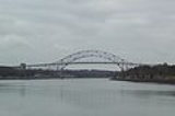
Sagamore Bridge
Overview
Sagamore, Massachusetts
Sagamore is a census-designated place in the town of Bourne in Barnstable County, Massachusetts, United States. The population was 3,544 at the 2000 census.-Geography:Sagamore is located at ....
carries U.S. Route 6
U.S. Route 6
U.S. Route 6 , also called the Grand Army of the Republic Highway, a name that honors an American Civil War veterans association, is a main route of the U.S. Highway system, running east-northeast from Bishop, California to Provincetown, Massachusetts. Until 1964, it continued south from Bishop to...
across the Cape Cod Canal
Cape Cod Canal
The Cape Cod Canal is an artificial waterway traversing the narrow neck of land that joins Cape Cod to mainland Massachusetts.Part of the Atlantic Intracoastal Waterway, the canal is roughly 17.4 miles long and connects Cape Cod Bay in the north to Buzzards Bay in the south...
, connecting Cape Cod
Cape Cod
Cape Cod, often referred to locally as simply the Cape, is a cape in the easternmost portion of the state of Massachusetts, in the Northeastern United States...
with the rest of Massachusetts
Massachusetts
The Commonwealth of Massachusetts is a state in the New England region of the northeastern United States of America. It is bordered by Rhode Island and Connecticut to the south, New York to the west, and Vermont and New Hampshire to the north; at its east lies the Atlantic Ocean. As of the 2010...
, USA
United States
The United States of America is a federal constitutional republic comprising fifty states and a federal district...
.
Most traffic approaching from the north follows Route 3
Route 3 (Massachusetts)
Route 3 is a southward continuation of U.S. Route 3, connecting Cambridge, Massachusetts with Cape Cod. All of it, except for the northernmost end in downtown Boston and Cambridge, is a freeway....
, which ends at US 6, just north of the bridge, and provides expressway
Controlled-access highway
A controlled-access highway is a highway designed exclusively for high-speed vehicular traffic, with all traffic flow and ingress/egress regulated...
connections from Boston and Interstate 93
Interstate 93
Interstate 93 is an Interstate Highway in the New England section of the United States. Its southern terminus is in Canton, Massachusetts, in the Boston metropolitan area, at Interstate 95; its northern terminus is near St. Johnsbury, Vermont, at Interstate 91...
.
The bridge, along with its sibling, the Bourne Bridge, was constructed beginning in 1933 by the Public Works Administration
Public Works Administration
The Public Works Administration , part of the New Deal of 1933, was a large-scale public works construction agency in the United States headed by Secretary of the Interior Harold L. Ickes. It was created by the National Industrial Recovery Act in June 1933 in response to the Great Depression...
for the United States Army Corps of Engineers
United States Army Corps of Engineers
The United States Army Corps of Engineers is a federal agency and a major Army command made up of some 38,000 civilian and military personnel, making it the world's largest public engineering, design and construction management agency...
, which operates both the bridges and the canal.
Unanswered Questions